54
31 Stoke Street Ipswich, Suffolk Client: Fastracker Developments Ltd. Date: March 2015 IPS 758 Archaeological Evaluation Report SACIC Report No. 2015/009 Author: M. Sommers © SACIC

31 Stoke Street
Ipswich, SuffolkClient: Fastracker Developments Ltd.
Date: March 2015
IPS 758Archaeological Evaluation ReportSACIC Report No. 2015/009Author: M. Sommers© SACIC

31 Stoke Street, Ipswich IPS 758
Archaeological Evaluation Report
SACIC Report No. 2015/009
Author: M. Sommers
Contributions By: R. Goffin and M. Green
Editor: S. Boulter
Report Date: March 2015

HER Information
Site Code: IPS 758 Site Name: 31 Stoke Street, Ipswich Report Number 2015/009 Planning Application No: IP/12/00916 Date of Fieldwork: 17th and 18th February 2015 Grid Reference: TM 1631 4383 Oasis Reference: suffolkc1-200297 Curatorial Officer: Dr A. Antrobus Project Officer: M. Sommers Client/Funding Body: Fastracker Developments Ltd. Client Reference: n/a
Digital report submitted to Archaeological Data Service:
http://ads.ahds.ac.uk/catalogue/library/greylit
Disclaimer Any opinions expressed in this report about the need for further archaeological work are those of Suffolk
Archaeology CIC. Ultimately the need for further work will be determined by the Local Planning Authority
and its Archaeological Advisors when a planning application is registered. Suffolk Archaeology CIC
cannot accept responsibility for inconvenience caused to the clients should the Planning Authority take a
different view to that expressed in the report.
Prepared By: M. Sommers
Date: 4th March 2015
Approved By: S. Boulter
Position: Senior Project Officer
Date:
Signed:

Contents
Summary
1. Introduction 1
2. Geology and topography 1
3. Archaeology and historical background 3
4. Methodology 5
5. Results 7
6. Finds and environmental evidence 11
6.1 Introduction 11
6.2 The Pottery 11
6.3 The Fired clay 13
6.4 The struck flint 13
6.5 Faunal remains 13
7. Discussion 13
8. Conclusions and recommendations for further work 14
9. Archive deposition 14
10. Acknowledgements 14
11. Bibliography 15
List of Figures
Figure 1. Location map 2 Figure 2. Trench location and summary of recorded features 6 Figure 3. Trench 1 - plan 9 Figure 4. Sections 10
List of Tables
Table 1. Summary of HER entries 4 Table 2. Finds quantities 11
List of Plates
Plate 1. Trench 1, pits 0001 and 0003, camera facing northeast (ref. HZI 84) 16 Plate 2. Trench 1, ditch 0006, camera facing southeast (ref. HWZ 87) 16 Plate 3. Trench 1, pit 0008, camera facing south (ref. HZI 89) 17 Plate 4. Trench 1, pit 0010, camera facing west (ref. HZI 91) 17 Plate 5. Trench 1, pit 0012, camera facing east (ref. HZI 93) 18 Plate 6. Trench 2, general view, camera facing west (ref. HWZ 96) 18
List of Appendices
Appendix 1. Written Scheme of Investigation Appendix 2. Context List Appendix 3. OASIS data collection form
Appendix 4. Pottery catalogue
Summary
An archaeological evaluation was carried out at 31 Stoke Street, Ipswich, in advance of
a residential development. Two trenches were excavated revealing a small number of
features. Finds evidence suggests that at least some of these date from the medieval
period. These were interpreted as rubbish pits suggesting occupation in the immediate
vicinity, presumably on the street frontage, an area now under later buildings. The site
was located in an area that sloped down from west to east and to the north, although
this is now heavily landscaped. On the street frontage and along the western arm of the
‘L’ shaped site it was clear that the surface of the natural subsoil had been truncated to
form a roughly level terrace and that Stoke Street itself in this area is a sunken lane cut
into the side of the slope. This is further evidenced by the presence of a revetting wall
topped by a steep slope on the west side of the street, adjacent to St. Mary’s
churchyard. Occasional sherds of Middle Saxon Ipswich ware and some possible Late
Saxon Thetford-type ware were also recovered as residual finds in the medieval
features (Suffolk Archaeology CIC for Fastracker Developments Ltd.)

1
1. Introduction
Planning permission has been granted for a residential development on land at 31,
Stoke Street, Ipswich, Suffolk (application number IP/12/00916). One of the conditions
attached to the planning consent called for a programme of archaeological work to be in
place in advance of this development.
The first stage of the programme of work, as specified in a Brief produced by Dr. Abby
Antrobus of the Suffolk County Council Conservation Team, was the undertaking of a
trenched evaluation in order to ascertain what levels of archaeological evidence may be
present within the development area and to inform any mitigation strategies that may
then be deemed necessary. Based on this brief a Written Scheme of Investigation (WSI)
was produced and subsequently approved by the Conservation Team (Appendix 1).
The National Grid Reference for the approximate centre of the site is TM 1631 4383.
Figure 1 shows a location plan of the site.
The archaeological evaluation was carried out on the 17th and 18th February 2015 by
Suffolk Archaeology Community Interest Company (SACIC) who were commissioned by
Peter Wells Architects Ltd., acting on the behalf of their client, Fastracker Developments
Ltd.
2. Geology and topography
The development area is located at between c.10m and 11m above sea level, on a
northeast facing slope that runs from a high area to the west down to the River Orwell,
which flows west to east in a channel approximately 90m to the north. This slope has
been previously landscaped and now forms a series of terraces divided by occasional
small pockets of what are possibly remnants of the natural slope. Stoke Street, to the
west of the site, climbs up from the north along the eastern boundary of St. Mary’s
churchyard, from which it is separated by a brick built revetting wall with a steep slope
beyond.
The underlying geology consists of clay, silt and sand of the Thanet Sand Formation
And Lambeth Group, which is overlain with sand and gravel deposits (British Geological
Survey).

2
Figure 1. Location map
Contains Ordnance Survey data © Crown copyright 2015

3
3. Archaeology and historical background
A number of archaeological sites or findspots are recorded on the Historic Environment
Record (HER) within the vicinity of the development site. A summary of these entries is
presented in the following table; the recorded locations of which are marked in Figure 1.
HER No. Address Date Nature of Evidence IPS055 Foundry
Lane/College Street
Sax Pair of bone skates with skeleton of a youth at depth of 11 feet, in old river mud, found in E corner of Foundry Lane & College Street.
IPS072 Stoke Hill Pal Flint implements and Pleistocene mammals. Found in construction of Stoke Hill Tunnel. Investigation of the railway cutting etc. revealed a black layer of bones and associated flints (Stoke bone beds, probably from Ipswichian Interglacial).
IPS139 Church of St Mary, Stoke
Med St. Mary's Church. 1870-1872 new nave, chancel and S porch. Original church became north aisle and Lady Chapel.
IPS141 Vernon Street Sax, Med & PMed
Excavation revealed a large ditch 4m by 1.65m, four pits (plus two aceramic pits), group of undateable post holes and a foundation trench. Finds include bronze tweezers, pin, sheepbell, iron pin, knives, shears, handle, arm with shaped copper alloy terminal, rhenish lava quern, glass fragments, loomweight, bone comb fragments and needles. Pottery: Ipswich ware, Badorf type ware, relief band amphora. Jet fragments. Residual worked flint and Rom tile also recovered.
IPS142 Great Whip Street /Gower Street
Sax Ipswich ware in lower topsoil and Thetford type ware from in foundation trenches dug for new warehouse. Waterlogged remains reported but these were not seen by archaeologists at the time.
IPS143 Great Whip Street
Rom, Sax & Med
Excavation revealed one pit (?Rom) and residual finds along with Middle and Late Saxon features. Also Medieval pits and an oven.
IPS144 Great Whip Street
Sax & Med
Excavation revealed Middle Saxon features and finds and one Late Saxon slot. Also three pits C11/C12, ditch parallel to Great Whip Street, two pits later Med.
IPS145 Stoke Med Hospital of St Leonard, Leper Hospital, relying chiefly on the alms of travellers. Approximate position in parish of St Peter, near church of St Augustine.
IPS215 Grey Friars Road
Sax, Med & PMed
An area of Sax/Med occupation, now a car park. Excavations have revealed pits ranging in date from the C9 to the PMed period.
IPS223 Wolsey Gate, College Street
Med Brick gateway originally belonging to a proposed college which Wolsey was to set up at Ipswich. Over the door the coat of arms of the cardinal. The gateway was erected in 1528

4
IPS255 Stoke Mill, Stoke Bridge
Med & PMed
Stoke Mill & bridge across the Orwell/Gipping shown on Bowen's, Hodskinson's, Saxton's & Speede's maps. Construction dates unknown although Stoke Bridge is one of two (also Handford) earliest documented bridges in Suffolk, being recorded in c.970.
IPS269 Foundry Lane PMed Narrow slipway shown on 1837 drawings of Ipswich Dock area by Edward Caley. Foundry Lane appears to be on same alignment as the slipway which was presumably filled in upon construction of the Wet Dock.
IPS270 Stoke Quay Pmed King's Cooperidge marked on map of 1674. Shipyard marked on map of 1778. Site later cut through by the New Cut in 1830s.
IPS274 Church of St Peter
Med Church of St Peter. Now disused. Close to Augustinian Priory of St Peter & St Paul. Probably connected with Wolsey's College when the church served as a chapel to the college.
IPS278 Church of St Mary at the Quay, Foundation St
Med Church of St Mary at the Quay. Redundant. Brasses removed to Christchurch Mansion Museum, the font to Brantham and the pulpit to Elmsett.
IPS413 Ipswich Sax & Med
Medieval (including Saxon) town, defined as Area of Archaeological Importance in Local Plan.
IPS455 Former Cardinal Works Site
Sax, Med & PMed
Evaluation identified Early Saxon pottery, while only occurring in later features, the Early Saxon pottery must relate to the earliest pre-urban phase of occupation that developed into the town of Ipswich. Middle Saxon, Late Saxon and early medieval features were also widespread throughout the site. Predominantly comprising pits, there were also three substantial buildings, two surface lain, of post and slot construction with clay floors, and one possible Sunken Featured Building.
IPS517 Rectory Road PMed Brickworks and kiln mapped by OS in 1880s. No longer mapped by 1900s.
IPS630 Commercial Road
Med? Evaluation revealed a series of undated stakes and two ditches running parallel to the buried "Gipping Channel", possibly part of a flood defence system, aimed at keeping tidal water in the Gipping channel from flooding the drained marshes. They are possibly medieval in date.
IPS643 Stoke Quay Sax & Med
Evaluation in 2011 identified a medieval cemetery and excavation in 2012 revealed the Norman church of St Augustine (replacing earlier timber structure) and remainder of the cemetery (at least 1000 burials) and numerous medieval and Saxon features/finds. Med occupation traces across the whole site but concentrated close to Whip Street.
Table 1. Summary of HER entries

5
The recorded sites indicate significant Saxon and medieval occupation in the immediate
vicinity of the development site. The site also lies within the area defined for the Saxon
and medieval town of Ipswich and is adjacent to the Church of St. Mary, primarily a
medieval building (although greatly extended in the Victorian period). Given the
proximity of the recorded sites, the adjacent church and the development site’s location
within the limits of the Saxon and medieval town there was deemed to be a high
potential for further archaeological deposits to be present within the development area.
4. Methodology
The trial trenches were machine excavated down to the level of the natural subsoil
using a toothless bucket fitted to a small (3.5 tonne) mechanical excavator.
The machining of the trenches was closely observed throughout in order to identify any
archaeological features and deposits and to recover any artefacts that might be
revealed. Excavation continued until undisturbed natural deposits were encountered,
the exposed surface of which was then examined for cut features. Features or
significant deposits identified were then sampled through hand excavation in order to
determine their depth and shape and to recover datable artefacts. Scale plans and
sections of each recorded feature were drawn in pencil on permatrace sheets.
Relative heights were measured with a dumpy level and related to an incised Ordnance
Survey bench mark on the nearby Church of St. Mary (recorded height 16.61m OD).
A photographic record of the work undertaken was also compiled using an 18
megapixel digital camera.
Following excavation of each trench, the nature of the overburden was recorded and the
depths noted. The location of each trench was then related to the site boundary using
30m measuring tapes.

6
Figure 2. Trench location and summary of recorded features

7
5. Results
Two evaluation trenches were excavated. One 17m in length (Trench 1) and the other
14.5m in length (Trench 2). Within Trench 1 a number of features were identified. The
trench locations and a summary of the recorded features over a plan of the proposed
development (extract from drawing PW568-PL01, dated Oct 2012) are marked in
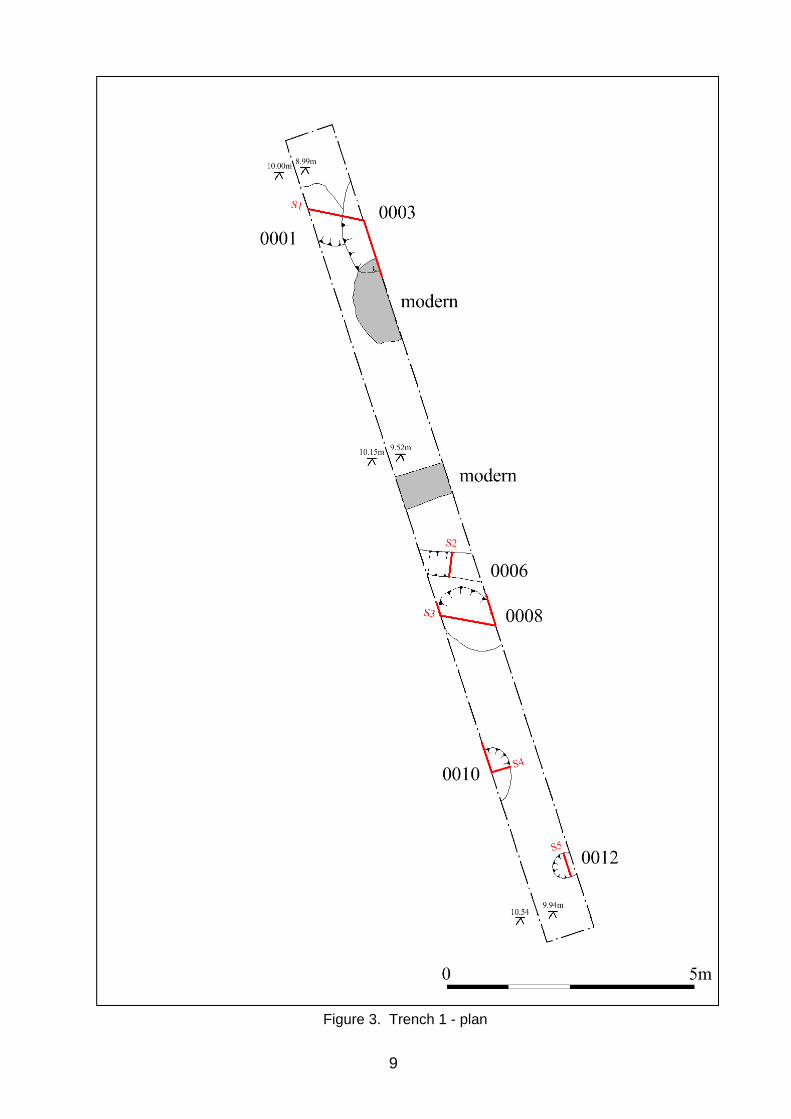
Figure 2. A larger scale plan of Trench 1 is presented as Figure 3 and the recorded
sections are reproduced in Figure 4.
Trench 1 was aligned approximately north to south along an area of site that sloped
down gently to the north. Six features of potential archaeological significance were
recorded along with two clearly modern disturbances.
For much of the southern end of the trench the subsoil lay at a depth of c.0.6m below
the ground level before dipping to a depth of c.1m below ground level at the northern
end. The relative heights of the present ground level and the surface of the subsoil are
marked in Figure 3. At the northern, lower end of the trench the natural subsoil
comprised a clayey sand with broken flint, which became increasingly sandy towards
the south. The overburden consisted of a thin patchy layer of crushed brick rubble and
small fragments of concrete over a deposit of relatively sterile dark silt/loamy topsoil
which increased in thickness towards the northern end of the trench. This overlay a
layer of pale greyish-yellow sand, which lay directly over the natural subsoil.
The recorded features are as follows:
0001: An irregular shaped pit of which an unknown proportion lay beyond the western
edge of the trench (plate 1). The feature cut the natural subsoil to a depth of c.0.45m
and was filled with a single homogenous deposit of dark brown sandy silt (0002), which
yielded sherds of pottery dated to the medieval period along with a small number of
residual Anglo-Saxon sherds. Cut by the adjacent pit 0003.
0003: A second irregular shaped pit, adjacent to and cutting pit 0001 (plate 1), larger,
although the precise dimensions were unknown as a proportion lay beyond the eastern
edge of the trench, and significantly deeper, cutting the natural subsoil to a depth of
0.8m. Two fills were evident, a lower fill (0004) of very dark brown to black sandy silt
8
overlain by a deposit of a similar but slightly paler material (0005). A number of finds
were recovered from the upper fill, these have been dated to the medieval period
although some may be earlier.
0006: A linear feature, probably a boundary ditch (plate 2). It measured 0.5m in width
and cut the natural subsoil to a depth of 0.24m. The fill (0007) comprised a dark grey
brown sandy silt which yielded a single sherd of possibly medieval pottery.
0008: A large pit, sub-circular in shape with near vertical sides and flat base at a depth
of 0.82m below the level of the natural subsoil (plate 3). The fill (0009) consisted of dark
brown to black silty sand from which no finds were recovered
0010: A pit located on and beyond the western edge of the trench (plate 4). Cuts the
natural subsoil to a depth of 0.32m. The fill (0011) consists of dark grey sandy silt from
which a single sherd of Hollesley-type ware dating to the late 13th-14th century was
recovered.
0012: A small circular shaped pit or possible posthole measuring approximately 0.5m in
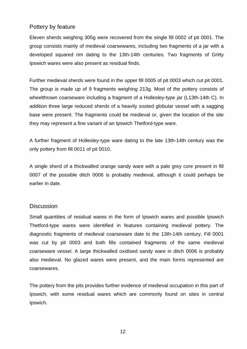
diameter with near vertical sides down to flat base at a depth of 0.3m (plate 5). The fill
(0013) comprised dark grey sandy silt which yielded no finds.
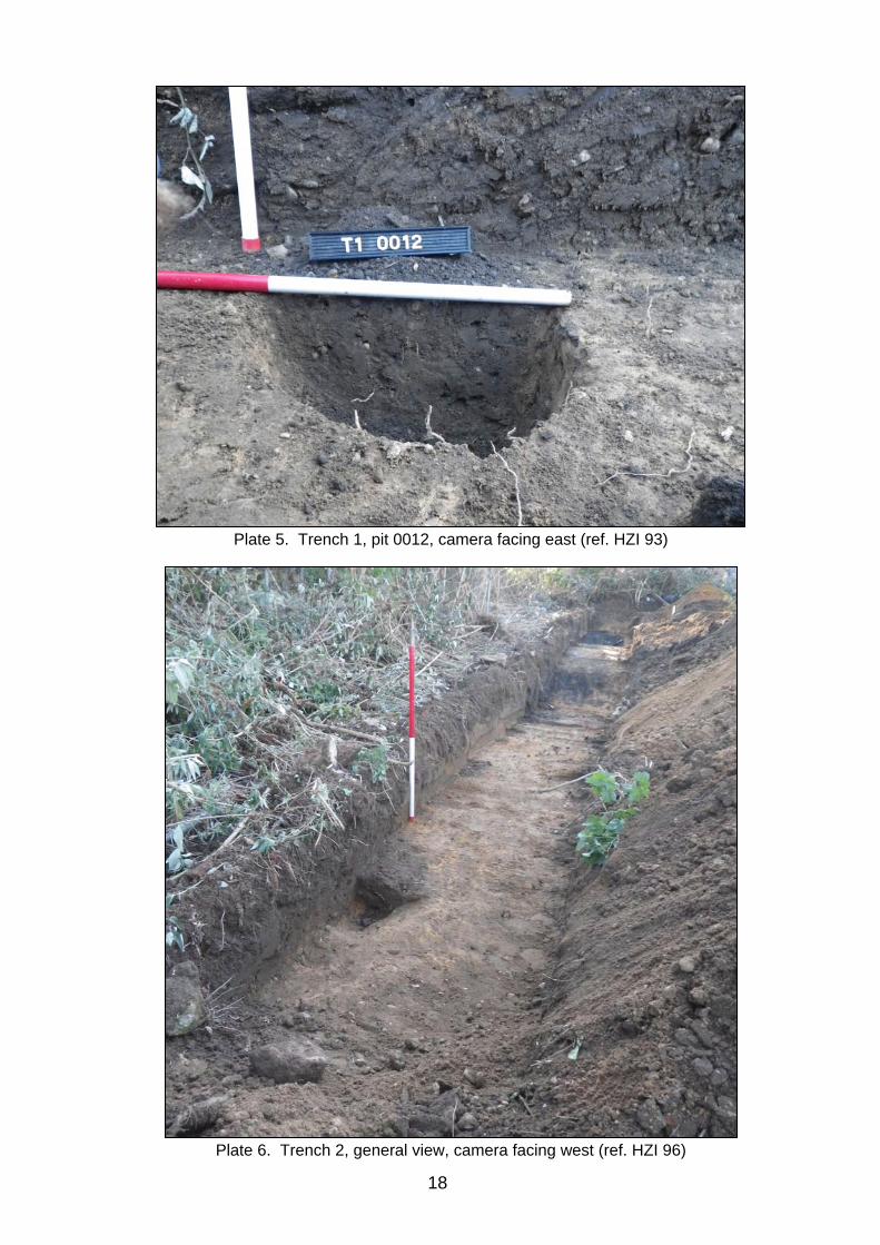
Trench 2 was aligned approximately east to west along an area of site that sloped very
gently down to the west. The relative heights recorded at each end are 10.52m at the
east end and 10.39m at the west end. A number of features were revealed but all were
clearly of modern origin and were not recorded (plate 6). At the east end the natural
subsoil lay at a depth of c.0.45m below an overburden of dark topsoil with late post-
medieval debris but this quickly rose until it lay at a depth of just 0.1m below the present
ground level. The interface between the natural subsoil and the overburden was
extremely sharp suggesting the surface of the natural subsoil had been truncated,
presumably to create a roughly level terrace on what was likely to have originally been
an east facing slope and to facilitate access onto Stoke Street, which appears to be a
sunken lane running across the slope and revetted by a substantial brick wall that runs
along its western edge.
9
Figure 3. Trench 1 - plan

10
Figure 4. Sections

11
6. Finds and environmental evidence
Richenda Goffin
6.1 Introduction
The small quantity of finds recovered from the features in Trench 1 of the evaluation are
listed below.
Context Pottery Fired clay Flint Animal bone Spotdate
No. Wt/g No. Wt/g No. Wt/g No. Wt/g 0002 11 305 2 84 1 37 4 133 13th-14th C 0005 9 213 L13th-14th C 0007 1 24 Medieval? 0010 1 8 L13th-14th C Total 22 550 2 84 1 37 4 133
Table 2. Finds quantities
6.2 The Pottery
Introduction
A total of 22 fragments of pottery weighing 550g was recovered from the evaluation.
The assemblage is mainly medieval, but there are a few earlier residual sherds.
Methodology
The ceramics were quantified using the recording methods recommended in the MPRG
Occasional Paper No 2, Minimum standards for the processing, recording, analysis and
publication of Post-Roman ceramics (Slowikowski et al 2001). The number of sherds
present in each context by fabric, the estimated number of vessels represented and the
weight of each fabric group was noted. Other characteristics such as form, decoration
and condition were recorded, and an overall date range for the pottery in each context
was established. The pottery was catalogued by context using letter codes based on
fabric and form and the data has been inputted as on the database (Appendix 4). The
codes used are based mainly on broad fabric and form types identified in Eighteen
centuries of pottery from Norwich (Jennings 1981), and additional fabric types
established by the Suffolk Unit (S Anderson, unpublished fabric list).
12
Pottery by feature
Eleven sherds weighing 305g were recovered from the single fill 0002 of pit 0001. The
group consists mainly of medieval coarsewares, including two fragments of a jar with a
developed squared rim dating to the 13th-14th centuries. Two fragments of Gritty
Ipswich wares were also present as residual finds.
Further medieval sherds were found in the upper fill 0005 of pit 0003 which cut pit 0001.
The group is made up of 9 fragments weighing 213g. Most of the pottery consists of
wheelthrown coarseware including a fragment of a Hollesley-type jar (L13th-14th C). In
addition three large reduced sherds of a heavily sooted globular vessel with a sagging
base were present. The fragments could be medieval or, given the location of the site
they may represent a fine variant of an Ipswich Thetford-type ware.
A further fragment of Hollesley-type ware dating to the late 13th-14th century was the
only pottery from fill 0011 of pit 0010.
A single sherd of a thickwalled orange sandy ware with a pale grey core present in fill
0007 of the possible ditch 0006 is probably medieval, although it could perhaps be
earlier in date.
Discussion
Small quantities of residual wares in the form of Ipswich wares and possible Ipswich
Thetford-type wares were identified in features containing medieval pottery. The
diagnostic fragments of medieval coarseware date to the 13th-14th century. Fill 0001
was cut by pit 0003 and both fills contained fragments of the same medieval
coarseware vessel. A large thickwalled oxidised sandy ware in ditch 0006 is probably
also medieval. No glazed wares were present, and the main forms represented are
coarsewares.
The pottery from the pits provides further evidence of medieval occupation in this part of
Ipswich, with some residual wares which are commonly found on sites in central
Ipswich.

13
6.3 The Fired clay Two fragments of fired clay were recovered from fill 0002 of pit 0001. Both are made
from the same fabric, a fine matrix of poorly mixed clay with sparse calcareous
inclusions, probably shell. Their function is unknown.
6.4 The struck flint A single struck flint was collected as a residual find from fill 0002 of pit 0001. It is a light
grey brown flint with light grey chert patches and light patination with multiple flake scars
on the dorsal edge. There is moderate edge damage with signs of retouch on one of the
edges. Approximately 2% is made up of cortex. The fragment is possibly a blade core
rejuvenation flake, and is most likely to date to the Neolithic/Bronze Age.
6.5 Faunal remains Three fragments of animal bone were recovered from fill 0002 of pit 0001. These
include a fragment of a bovine jawbone with three molars, and the distal end of a
sheep’s tibia.
7. Discussion
The evaluation revealed a small number of features that have been dated to the
medieval period. The two larger pits at the northern end of Trench 1 (0001 and 0003)
are likely to be rubbish pits and as such are evidence for medieval occupation, probable
domestic dwellings that would have fronted onto Stoke Street or possibly Burrell Road
to the north, both of which are likely to be early thoroughfares. No positive evidence for
the presence of actual structures was identified within the trenches. Two other features
(ditch 0007 and pit 0010) yielded only single sherds of medieval pottery and therefore
cannot be securely dated, although they could potentially be medieval. The undated
features may also be medieval, or possibly earlier, as there was no evidence to suggest
they were modern.
The soil profile revealed in Trench 2 suggests the area of the site adjacent to Stoke
Street has been truncated. This is presumably a result of landscaping of a natural slope
to create a level terrace at a similar level to Stoke Street, which appears to be a sunken
lane that cuts deeply into the slope, as testified by the revetment wall and steep slope
along the eastern edge of the churchyard. This truncation could potentially be medieval
in date but the only features noted in this area were clearly modern.

14
8. Conclusions and recommendations for further work
The evaluation has confirmed that archaeological features dating from the medieval
period survive within the eastern, north-south arm of this ‘L’ shaped site at a depths of
c.0.6m increasing to c.1m to the north.
The two most productive features, with regards to finds, were located close to the
northern end of Trench 1. Comparison of the trench plan overlain on a plan of the
proposed development, as supplied by the client (drawing PW568-PL01; dated Oct
2012 – see Fig. 2), shows that these lie outside the footprint of the proposed structure,
the greater part of which lies along the southern, east-west, arm of the site. The
remainder of the site appears to be laid over to hardstanding or open green space,
which would suggest the known area of what is relatively deeply buried archaeology is
not under obvious threat, although the precise distribution and depth of any proposed
groundworks associated with this development, such as service runs and soak-aways,
are at present unknown.
The final decision on the need for further work is at the discretion of the County
Conservation Team.
9. Archive deposition
Paper, digital and photographic archive will be sent to the County HER, ref. IPS758.
SACCIC digital photograph refs. HZI 83 to HZI 99.
The Finds archive will ultimately to be deposited with the local museums service
10. Acknowledgements
The fieldwork was carried out by Tim Carter, Mark Sommers and Robert Templar.
Project management was undertaken by Stuart Boulter who also provided advice during
the production of the report and provided final editing.
The Finds report was produced by Richenda Goffin with advice from Mike Green who
identified the struck flint.

15
11. Bibliography
Jennings, S., 1981, Eighteen Centuries of pottery from Norwich. EAA 13, Norwich Survey/NMS. Slowikowski, A., Nenk, B., and Pearce, J., 2001, Minimum standards for the processing, recording, analysis and publication of post-Roman ceramics, MPRG Occasional Paper No 2.

16
Plates
Plate 1. Trench 1, pits 0001 and 0003, camera facing northeast (ref. HZI 84)
Plate 2. Trench 1, ditch 0006, camera facing southeast (ref. HZI 87)

17
Plate 3. Trench 1, pit 0008, camera facing south (ref. HZI 89)
Plate 4. Trench 1, pit 0010, camera facing west (ref. HZI 91)
18
Plate 5. Trench 1, pit 0012, camera facing east (ref. HZI 93)
Plate 6. Trench 2, general view, camera facing west (ref. HZI 96)

Appendix 1. Written Scheme of Investigation

31 Stoke Street Ipswich, Suffolk
Archaeological Evaluation:
Written Scheme of Investigation
Prepared by Suffolk County Council Archaeological Service Field Team
January 2015
Document Control
Title: 31 Stoke Street, Ipswich, Suffolk, Archaeological Evaluation: Written Scheme of Investigation
Date: January 2015
Issued by: Suffolk County Council Archaeological Service Field Team
Author: Stuart Boulter
Checked by: N/A
Issued to: Suffolk County Council Archaeological Service Conservation Team and Peter Wells Architects
Contents
1. Background
2. Project Objectives
3. Project Details
4. Archaeological Method Statement
Figures
1. Site location
2. Site detail and proposed trench locations
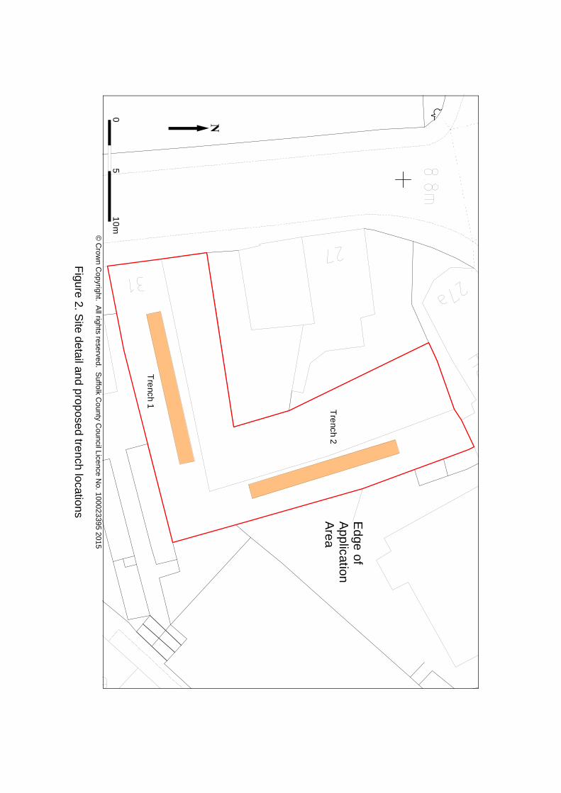
1 Background
The Field Team of the Suffolk County Council Archaeological Service (SCCAS) have
been commissioned by Peter Wells Architects (on behalf of their client) to undertake
a programme of archaeological evaluation on land at 31 Stoke Street, Ipswich,
Suffolk (app. no. IP/12/00916) (TM 1630 4382) (Figure 1).
The site covers an area of approximately 0.04 hectares (400 square metres).
A Brief for these works was produced by the Suffolk County Council Archaeological
Service Conservation Team (hereafter SCCAS/CT) Archaeologist Abby Antrobus in
a document dated 11th December 2015. All SCCAS Field Team work will adhere to
the requirements of this document.
The archaeological potential for the site is based on its location within the Area of
Archaeological Importance as defined for Ipswich Anglo-Saxon and medieval town
ain the Ipswich Local Plan (County Historic Environment Record IPS 413). The site
lies immediately east of the early church of St. Mary (IPS 139) and is close to the
waterfront. There is considered to be a high potential for deposits of Anglo-Saxon
and medieval date to survive on the site.
This evaluation will be carried out by members of SCCAS Field Team under the
supervision of Project Officer Mark Sommers. Stuart Boulter will undertake the
project management.
The work is projected to be undertaken in the week beginning 16th February 2015,
the fieldwork for which will last between one and two days.

2 Project Objectives
PO1: Identify the date, approximate form and purpose of any archaeological deposit
within the application area, together with its likely extent, localised depth and
quality of preservation.
PO2: Evaluate the likely impact of past land uses, and the possible presence of
masking colluvial deposits.
PO3: Establish the potential for the survival of environmental evidence.
PO4: Provide sufficient information to construct an archaeological conservation
strategy, dealing with preservation, the recording of archaeological deposits,
timetables and orders of cost.

Sit
e
50
0m
me
tre
s
25
0
0
0
©
Cro
wn
Cop
yrig
ht.
All
right
s re
serv
ed.
Suf
folk
Cou
nty
Cou
ncil
Lice
nce
No.
100
023
395
2015
Fig
ure
1. S
ite lo
catio
n
Ed
ge
of
Ap
plica
tion
A
rea
Tre
nch 1
Tre
nch 2
10
m5
0
© C
row
n Cop
yright. A
ll rights reserved. Suffolk C
ounty Council Licence N
o. 100023
395 2015
Figure 2. S
ite detail and proposed trench locations
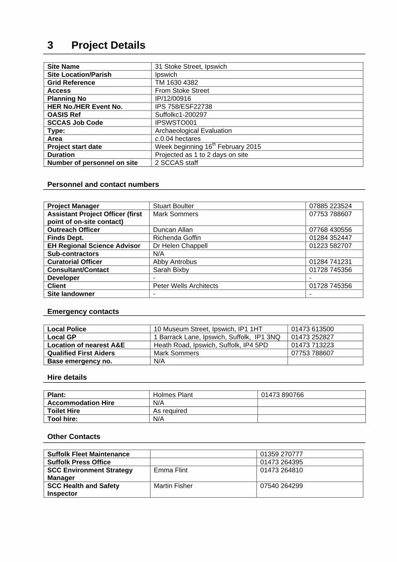
3 Project Details Site Name 31 Stoke Street, Ipswich Site Location/Parish Ipswich Grid Reference TM 1630 4382 Access From Stoke Street Planning No IP/12/00916 HER No./HER Event No. IPS 758/ESF22738 OASIS Ref Suffolkc1-200297 SCCAS Job Code IPSWSTO001 Type: Archaeological Evaluation Area c.0.04 hectares Project start date Week beginning 16th February 2015 Duration Projected as 1 to 2 days on site Number of personnel on site 2 SCCAS staff
Personnel and contact numbers
Project Manager Stuart Boulter 07885 223524 Assistant Project Officer (first point of on-site contact)
Mark Sommers 07753 788607
Outreach Officer Duncan Allan 07768 430556 Finds Dept. Richenda Goffin 01284 352447 EH Regional Science Advisor Dr Helen Chappell 01223 582707 Sub-contractors N/A Curatorial Officer Abby Antrobus 01284 741231 Consultant/Contact Sarah Bixby 01728 745356 Developer - - Client Peter Wells Architects 01728 745356 Site landowner - - Emergency contacts Local Police 10 Museum Street, Ipswich, IP1 1HT 01473 613500 Local GP 1 Barrack Lane, Ipswich, Suffolk, IP1 3NQ 01473 252827 Location of nearest A&E Heath Road, Ipswich, Suffolk, IP4 5PD 01473 713223 Qualified First Aiders Mark Sommers 07753 788607 Base emergency no. N/A Hire details Plant: Holmes Plant 01473 890766 Accommodation Hire N/A Toilet Hire As required Tool hire: N/A Other Contacts Suffolk Fleet Maintenance 01359 270777 Suffolk Press Office 01473 264395 SCC Environment Strategy Manager
Emma Flint 01473 264810
SCC Health and Safety Inspector
Martin Fisher 07540 264299
4 Archaeological method statement
Fieldwork
The archaeological fieldwork will be carried out by members of the SCCAS Field
Team led by Project Officer Mark Sommers. The primary team of two will include an
experienced metal detectorist/excavator from a pool of suitable staff at SCCAS.
The c.0.04 hectare site is located on the eastern side of Stoke Street and is bounded
to the north and south by extant buildings and to the east by an incised terrace
associated with a block of flats (Figures 1 and 2).
The Brief (section 4.1) states that archaeological trial-trenching should be
undertaken on the site with a representative sample, which in this instance would
equate to two 10m – 15m long trenches with a minimum width of 1.5m (section 4.4).
Figure 2 provides an indicative location for the two proposed trenches.
All mechanical excavation will be undertaken using a toothless ditching bucket for a
good clean cut and will be constantly supervised by an experienced archaeologist.
Topsoil and overburden will be removed stratigraphically by the mechanical
excavator. The trenches will be excavated down to the top of the first undisturbed
archaeological horizon, or the upper surface of the naturally occurring subsoil. Spoil
will be temporarily stockpiled next to the trench with topsoil stored separately to any
underlying colluvial material.
There may be the need to remove additional masking subsoil layers such as
hillwash (colluvium).
After excavation and recording, the trenches will be backfilled by pushing the upcast
spoil back in sequentially using the mechanical excavator. Formal reinstatement is
not the responsibility of the archaeological contractor.
The character of the site suggests that it is quite possible that live services could be
present. As no information has been provided by the client, any damage incurred to
hitherto unknown services is not the responsibility of the archaeological contractor.
Although the trenches are unlikely to be deep (<1200mm is anticipated, although
localised areas with colluvium could be deeper), they will be backfilled as soon as
possible. Where deep trenches are left open over night to facilitate visits by various
interested parties, fencing will be employed. If deposits deeper than 1200mm are
encountered SCCAS/CT will be consulted in order to explore options such as
shoring or battering of trenches.
Archaeological features and deposits will be sampled by hand excavation and the
trench bases and sections cleaned and recorded as necessary in order to satisfy the
project aims. While there is a presumption that the excavation work will cause
minimum disturbance consistent with adequate evaluation, with solid or bonded
structural remains, building slots or post-holes preserved intact, even if sampled, the
following guidelines will be maintained:
A minimum of 1m wide slots will be excavated across linear features
50% of discrete features, such as pits, will be sampled, although in some
instances 100% may be required
Sufficient excavation will be undertaken to provide clear evidence for the period,
depth and nature of any archaeological deposit. The depth and character of any
colluvial or any other masking deposit will be established across the site.
A site plan, which will show the trench location and other areas of investigation,
feature positions and levels will be recorded, where necessary, a RTK GPS or TST
will be used, otherwise trenches will located by triangulation from extant structures
and boundaries. Feature sections and plans will be recorded at 1:20 or 1:50 as
appropriate. Normal SCCAS Field Team conventions, compatible with the County
HER, will be used during the site recording.
The site will be recorded under the HER site code IPS 758 (Event No. ESF22738).
All archaeological features and deposits will be recorded using standard pro forma
SCCAS Field Team Context Recording Sheets.

A photographic record (high resolution digital) will be made during the evaluation.
Metal detector searches will be made at all stages of the project covering both the
upcast spoil and the base of the trenches.
All pre-modern finds will be kept and no discard policy will be considered until all the
finds have been processed and assessed. Finds on site will be treated according to
‘First Aid For Finds’ and a conservator will be available for on-site consultation as
required.
All finds will be taken to the SCCAS Bury St. Edmunds office for processing,
preliminary conservation and packing. Much of the archive and assessment
preparation work will be done at the Bury St. Edmunds office, but in some
circumstances it may be necessary to send some categories of finds to specialists
working in archaeology and university departments in other parts of the country.
In order to obtain palaeoenvironmental evidence, bulk soil samples (30-40 litres
each) will be taken from selected archaeological features, particularly those which
are both datable and interpretable, and retained until an appropriate specialist has
assessed their potential for palaeoenvironmental remains. Decisions will be made
on the need for further analysis following this assessment. If necessary advice will
be sought from Dr Helen Chappell, English Heritage Regional Advisor in
Archaeological Science, on the need for specialist environmental sampling. Two
samples have been covered by the project costing, should SCCAS/CT require
additional samples to be collected and processed then increased costs would be
occurred.
In the event of human remains being encountered on the site, guidelines from the
Ministry of Justice will be followed and a suitable licence obtained before their
removal from the site. Human remains will be treated at all stages with care and
respect, and will be dealt with in accordance with the law. They will be recorded in
situ and subsequently lifted, packed and marked to standards compatible with those
described in the IFA’s Technical Paper 13 Excavation and post-excavation treatment
of Cremated and Inhumed Human Remains, by McKinley & Roberts. Following full
recording and analysis, where appropriate, the remains will be reburied.
Fieldwork standards will be guided by ‘Standards and Guidance for Archaeological
Excavation’ (IFA, 1995, revised 2001), ‘Standards for Field Archaeology in the East
of England (EAA Occasional Papers 14, 2003), SCCAS/CT Requirements for a
Trenched Archaeological Evaluation 2011 ver. 1.3 and SCCAS Archive Guidelines
2010.
Due to the limited nature of the job, SCCAS staff will work from their vehicle and use
public welfare facilities.
Post-excavation
General
Post-excavation finds work will be managed by Richenda Goffin (Bury St. Edmunds
Office) with the overall post-excavation reporting work the responsibility of Mark
Sommers and managed by Stuart Boulter (both Ipswich Office).
An archive of all records and finds will be prepared, consistent with the principles of
MoRPHE. It will be adequate to perform the function of a final archive for deposition
in the Archaeological Store of SCCAS/CT or in a suitable museum in Suffolk (see
Archaeological Archives Forum: a guide to best practice 2007).
The project manager will consult the intended archive depository before the archive
is prepared regarding the specific requirements for the archive deposition and
curation to include the specific cost implications of deposition. The final repository
(in this SCCAS/CT) will accept the entire archive resulting from the project (both
finds and written records) in order to create a complete record of the project. To that
end, the archive will comply with SCCAS Archive Guidelines 2010.
All site data will be entered on a computerised database compatible with the County
HER. Site plans and sections will be copied/scanned and digitised to form a
permanent archive on archivally stable material. Ordnance Datum levels will be on
the section sheets. The photographic archive will be fully catalogued within the
SCCAS photographic index.
All finds will be processed, marked and bagged/boxed following ICON guidelines
and the requirements of the County HER. All finds will be marked with a site code
and a context number.
Bulk finds will be fully quantified on a computerised database compatible with the
County HER. Quantification will fully cover weights and numbers of finds by OP and
context with a clear statement for specialists on the degree of apparent residuality
observed.
Metal finds on site will be stored in accordance with ICON guidelines, initially
recorded and assessed for significance before dispatch to a conservation laboratory
within four weeks of the end of the excavation. All pre-modern silver, copper alloy
and ferrous metal artefacts will be x-rayed and coins will be x-rayed if necessary for
identification. Sensitive finds will be conserved if necessary and deposited in
bags/boxes suitable for long term storage to ICON standards. All coins will be
identified to a standard acceptable to normal numismatic research.
Finds reports
Specialist finds reports will be undertaken in-house or commissioned as necessary to
meet the following requirements at assessment level:
The site archive will meet the standards set by ‘The Guideline for the preparation of
site archives and assessments of all finds other than fired clay vessels’ of the
Roman Finds Group and Finds Research Group AD700 - 1700 (1993).
The pottery will be recorded and archived to a standard consistent with the Draft
Guidelines of the Medieval Pottery Research Group and Guidelines for the archiving
of Roman Pottery, SGRP (ed. M.G. Darling, 1994).
Environmental samples will be processed and assessed to standards set by the
Regional Environmental Archaeologist (Dr Helen Chapell) with a clear statement of
potential for further analysis.
Animal and human bone will be quantified and assessed to a standard acceptable to
national and regional English Heritage specialists.
An industrial waste assessment will cover all relevant material (i.e. fired clay finds as
well as slag).
Reporting
The evaluation report will contain a stand-alone summary and a description of the
excavation methodology. It will also contain a clear separation of the objective
account of the archaeological evidence from its archaeological interpretation and
recommendations to assist the Planning Officer. It will contain sufficient information
to stand as an archive report should further work not be required.
The report will present a clear and concise assessment of the archaeological value
and significance of the results and will be related to relevant known archaeological
information held in the Suffolk HER.
The finished report will also include an opinion as to the necessity for further
evaluation and the scope of these works although the final decision will be made by
SCCAS/CT. No further site work will be undertaken until the evaluation results have
been assessed and the need for and scope of additional work established by
SCCAS/CT.
Following approval of a draft copy of the report, a single hard copy as well as a
digital copy of the approved report will be marked for the attention of the
archaeological officer, who will deposit it with the HER.
If applicable, a copy of the approved report will be sent to the local archaeological
museum.
An OASIS online record was initiated prior to the writing of this WSI document (Ref.
suffolkc1-200297). On completion of the projected, all the remaining applicable
fields will be filled in a copy will be included in the final report and with the site
archive. In addition, the final report (.pdf format) will be uploaded to the OASIS
website (http://ads.ahds.ac.uk/project/oasis/).

If positive results are drawn from the project, a summary report will be prepared, in
the established format, suitable for inclusion in the annual ‘Archaeology in Suffolk’
section of the Proceedings of the Suffolk Institute of Archaeology and History. The
summary will be included in the final report and will also be submitted to SCCAS/CT
by the end of the calendar year in which the work took place.
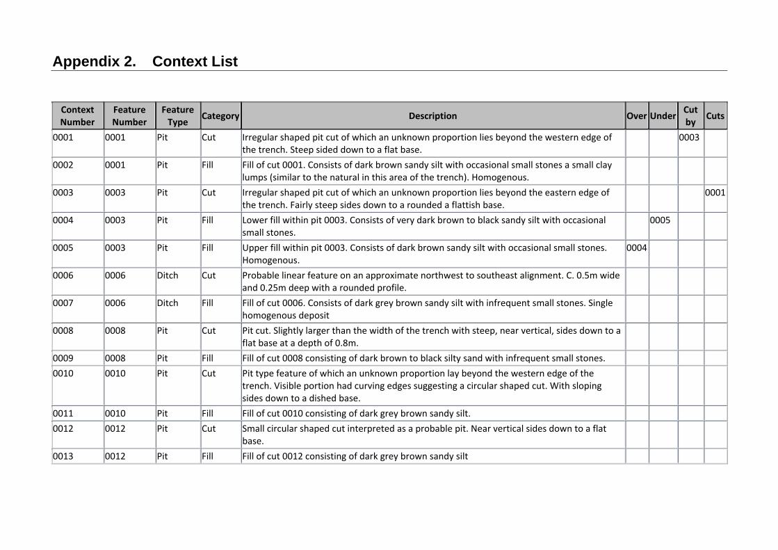
Appendix 2. Context List
Context Number
Feature Number
Feature Type Category Description Over Under Cut
by Cuts
0001 0001 Pit Cut Irregular shaped pit cut of which an unknown proportion lies beyond the western edge of the trench. Steep sided down to a flat base.
0003
0002 0001 Pit Fill Fill of cut 0001. Consists of dark brown sandy silt with occasional small stones a small clay lumps (similar to the natural in this area of the trench). Homogenous.
0003 0003 Pit Cut Irregular shaped pit cut of which an unknown proportion lies beyond the eastern edge of the trench. Fairly steep sides down to a rounded a flattish base.
0001
0004 0003 Pit Fill Lower fill within pit 0003. Consists of very dark brown to black sandy silt with occasional small stones.
0005
0005 0003 Pit Fill Upper fill within pit 0003. Consists of dark brown sandy silt with occasional small stones. Homogenous.
0004
0006 0006 Ditch Cut Probable linear feature on an approximate northwest to southeast alignment. C. 0.5m wide and 0.25m deep with a rounded profile.
0007 0006 Ditch Fill Fill of cut 0006. Consists of dark grey brown sandy silt with infrequent small stones. Single homogenous deposit
0008 0008 Pit Cut Pit cut. Slightly larger than the width of the trench with steep, near vertical, sides down to a flat base at a depth of 0.8m.
0009 0008 Pit Fill Fill of cut 0008 consisting of dark brown to black silty sand with infrequent small stones. 0010 0010 Pit Cut Pit type feature of which an unknown proportion lay beyond the western edge of the
trench. Visible portion had curving edges suggesting a circular shaped cut. With sloping sides down to a dished base.
0011 0010 Pit Fill Fill of cut 0010 consisting of dark grey brown sandy silt. 0012 0012 Pit Cut Small circular shaped cut interpreted as a probable pit. Near vertical sides down to a flat
base.
0013 0012 Pit Fill Fill of cut 0012 consisting of dark grey brown sandy silt


Appendix 3. OASIS data collection form
OASIS ID: suffolkc1-200297
Project details
Project name 31 Stoke Street Ipswich
Short description of
the project
Trenched evaluation revealed a small number of features dated to the
medieval period. These were interpreted as rubbish pits suggesting
occupation in the immediate vicinity, presumably on the street frontage, an
area now under later buildings.
Project dates Start: 17-02-2015 End: 27-02-2015
Previous/future work No / Not known
Any associated
project reference
codes
IPS758 - HER event no.
Any associated
project reference
codes
IP/12/00916 - Planning Application No.
Type of project Field evaluation
Current Land use Vacant Land 1 - Vacant land previously developed
Monument type PIT Medieval
Monument type DITCH Medieval
Significant Finds POTTERY Medieval
Significant Finds POTTERY Early Medieval
Methods &
techniques
''Sample Trenches''
Development type Urban residential (e.g. flats, houses, etc.)
Prompt National Planning Policy Framework - NPPF
Position in the
planning process
After full determination (eg. As a condition)
Project location
Country England
Site location SUFFOLK IPSWICH 31 Stoke Street
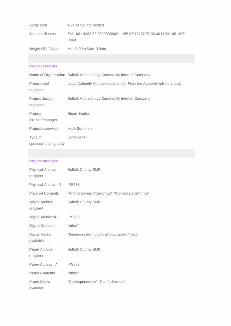
Study area 450.00 Square metres
Site coordinates TM 1631 4383 52.0500338662 1.15510518457 52 03 00 N 001 09 18 E
Point
Height OD / Depth Min: 8.99m Max: 9.94m
Project creators
Name of Organisation Suffolk Archaeology Community Interest Company
Project brief
originator
Local Authority Archaeologist and/or Planning Authority/advisory body
Project design
originator
Suffolk Archaeology Community Interest Company
Project
director/manager
Stuart Boulter
Project supervisor Mark Sommers
Type of
sponsor/funding body
Land owner
Project archives
Physical Archive
recipient
Suffolk County SMR
Physical Archive ID IPS758
Physical Contents ''Animal Bones'',''Ceramics'',''Worked stone/lithics''
Digital Archive
recipient
Suffolk County SMR
Digital Archive ID IPS758
Digital Contents ''other''
Digital Media
available
''Images raster / digital photography'',''Text''
Paper Archive
recipient
Suffolk County SMR
Paper Archive ID IPS758
Paper Contents ''other''
Paper Media
available
''Correspondence'',''Plan'',''Section''

Project bibliography
1
Publication type Grey literature (unpublished document/manuscript)
Title 31 Stoke Street Ipswich, Suffolk: Archaeological Evaluation Report
Author(s)/Editor(s) Sommers, M.
Other bibliographic
details
SACIC Report No. 2015/009
Date 2015
Issuer or publisher SACIC
Place of issue or
publication
Needham Market
Description printed sheets of A4 paper with card covers and a plastic comb binding
Entered by MS ([email protected])
Entered on 4 March 2015

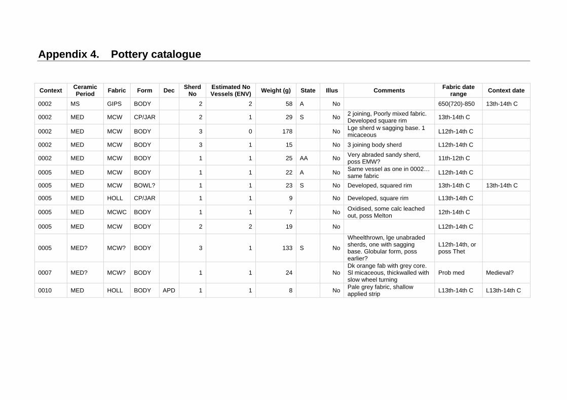
Appendix 4. Pottery catalogue
Context Ceramic Period
Fabric Form Dec Sherd
No Estimated No Vessels (ENV)
Weight (g) State Illus Comments Fabric date
range Context date
0002 MS GIPS BODY
2 2 58 A No 650(720)-850 13th-14th C
0002 MED MCW CP/JAR
2 1 29 S No 2 joining, Poorly mixed fabric. Developed square rim
13th-14th C
0002 MED MCW BODY
3 0 178
No Lge sherd w sagging base. 1 micaceous
L12th-14th C
0002 MED MCW BODY
3 1 15 No 3 joining body sherd L12th-14th C
0002 MED MCW BODY
1 1 25 AA No Very abraded sandy sherd, poss EMW?
11th-12th C
0005 MED MCW BODY
1 1 22 A No Same vessel as one in 0002… same fabric
L12th-14th C
0005 MED MCW BOWL?
1 1 23 S No Developed, squared rim 13th-14th C 13th-14th C
0005 MED HOLL CP/JAR
1 1 9 No Developed, square rim L13th-14th C
0005 MED MCWC BODY
1 1 7
No Oxidised, some calc leached out, poss Melton
12th-14th C
0005 MED MCW BODY
2 2 19
No
L12th-14th C
0005 MED? MCW? BODY
3 1 133 S No
Wheelthrown, lge unabraded sherds, one with sagging base. Globular form, poss earlier?
L12th-14th, or poss Thet
0007 MED? MCW? BODY
1 1 24
No Dk orange fab with grey core. Sl micaceous, thickwalled with slow wheel turning
Prob med Medieval?
0010 MED HOLL BODY APD 1 1 8
No Pale grey fabric, shallow applied strip
L13th-14th C L13th-14th C


Suffolk Archaeology CIC Unit 5 | Plot 11 | Maitland Road | Lion Barn Industrial Estate Needham Market | Suffolk | IP6 8NZ [email protected] 01449 900120 www.suffolkarchaeology.co.uk


