25
TECHNICAL PROPOSAL Geotechnical Investigation – Port & stockyard Development East Kutai Coal Project (EKCP) January 2010 Rev.1
TECHNICAL PROPOSAL Geotechnical Investigation – Port & stockyard Development
East Kutai Coal Project (EKCP)
January 2010 Rev.1

TECHNICAL PROPOSAL Geotechnical Investigation – Bridge, Stockyard and Port Belt Conveyor Development
East Kutai Coal Project (EKCP)
PT. DHV INDONESIA (DHV)
Geotechnical Investigation Bridge, Stockyard and Port Belt Conveyor Development
East Kutai Coal Project (EKCP)
Proposal Number: P20201
REV. 01
DATE
July 30, 2010
DESCRIPTIONIssued for Approval
AUTHOR
IRG

TECHNICAL PROPOSAL Geotechnical Investigation – Bridge, Stockyard and Port Belt Conveyor Development
East Kutai Coal Project (EKCP)
TABLE OF CONTENTS
1. INTRODUCTION………………………………………………………………………………………………………………….1
1.1. Background Information………………………………………………………………..……..…………..1
1.2. Objectives…………………………………………………………......................................2
1.3. Scope of Investigation……………………………………………………............................3
1.4. Outputs…………………………………………………………………….……………………….…..………….3
2. SCOPE DETAILS…………………….…………………………………………………………………………………………..4
2.1. Literature Study…………………………………………………….………………………………..…………4
2.2. Surface Geotechnical Mapping…………………………………….……….......................4
2.3. Geotechnical Drilling…………………………………….…………………………....................4
2.4. Cone Penetration Test……………….………………………………………….......................5
2.5. Standard Penetration Test…………………………………………….………......................6
2.6. Sample Testing In Geotechnical Laboratory...……….………….........................6
2.7. Geotechnical Data Processing…………..…………..……….…………........................6
2.8. Modeling and Slope Stability Analysis…………..………..……….……….…................7
2.9. Report Compilation…………..……………………………..……….…………......................7
2.10. Costs Estimate……..…………..……………………………..……….…………......................7
3. PROPOSED COST ESTIMATE………………………………………………….………………….……………….…….16
4. PROPOSED TIME SCHEDULE………………………………………………….………………….……………….…….17
5. PROJECT CONTROL SYSTEM….…………………………………………………………….…………………....18
6. COMMERCIAL PROPOSAL…….….…………………….……………………………………………………………...20
TECHNICAL PROPOSAL Geotechnical Investigation – Bridge, Stockyard and Port Belt Conveyor Development
East Kutai Coal Project (EKCP)
LIST OF FIGURES
Figure 1. Project Area…………………………………………………………………………………………………………2
Figure 2. Cone Penetration Test (CPT)……………………………………..…………………………....………5
LIST OF TABEL
Tabel 1. Costs estimate………………………………………….……………………………………………….….……7
LIST OF APPENDIX
Figure 3. Crossing River 1…………………………………………………………………………………………………..9
Figure 4. Crossing River 2………………………………………………………………………………………….………10
Figure 5. Crossing River 3………………………………………………………………………………………………….11
Figure 6. Lay Out of Geotechnical Drilling and Cone Penetration Test (CPT)
Investigation Plan at Bridge Area…………………………………………………………………….12
Figure 7. CPT Plan and Geotechnical Drilling Plan (1)..…………………………………………….……13
Figure 8. CPT plan and Geotechnical drilling Plan (2).……………..………………………....………14
Figure 9. Cross – Section Jetty line…………..………………………………………………………………….…15

TECHNICAL PROPOSAL Geotechnical Investigation – Port & stockyard Development
East Kutai Coal Project (EKCP)
Page 1 of 15
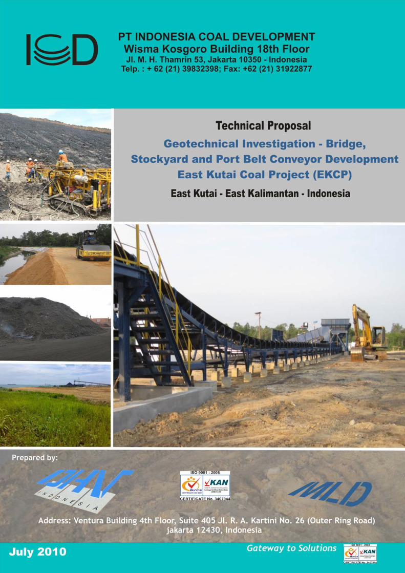
Introduction 1. Background Information
Coal is a major source of energy worldwide and is one of the largest contributors to the industrial growth of the country. The growth in coal production is due to the increase of coal demands, its international market price, and the discovery of new coal deposits. According to Directorate of General Mineral, Coal, and Geothermal (DESDM), 2007, Indonesia had 11,849 million tonnes of coal reserves and 93,402 million tonnes of coal resources. The coal deposits are spread out in Sumatera 52.5% (the biggest is in South Sumatra (39%)), in Kalimantan 40.4%, and others 0.4%. Based on Coal Quality, it consists of 25% of low calorie (<5,100 kcal/kg), 59% of medium calorie (5,100-6,100 kcal/kg), 14.9% of high calorie (6,100-7,100 kcal/kg), and 1.1% of very high (>7,100 kcal/kg). Nearly 80% of Indonesian Coal Production is rated as sub bituminous and has a niche position in domestic and international market.
Churchill Mining Plc. through PT Indonesia Coal Development (ICD) has significant coal resources in East Kutai, East Kalimantan and successfully defined 3.18 billion tones of coal (JORC compliant). ICD has finished exploration stage and currently preparing for infrastructure development stage.
The mine site covers approximately 775 km2, and is located at Muara Wahau, East Kutai Regency, and East Kalimantan Province. The mining method will be open pit. The produced coal will be transported to its two option transport corridor, first (for fast track program) will be hauled to coal stockpile at Batu Balai through hauling road along ± 60 Km, then transshipped by barge to Mahakam Delta (open sea), and the second one is transported by over land conveyor (OLC) along ± 160 Km to stock yard at Karang Tunjai (open sea). However, there are some potential problems due to existence of geological structures that influence the stability of soil and rock mechanic and may require ground improvement.
The development of bridge, stockyard, and port conveyor belt is strongly dependant on field characteristics and maintain the potential of instability by ground improvement methods by considering the soil, rock mass condition, soft soil/swamp materials and water influence. The development of port and stockyard facility need detailed investigation, analyses, and engineering review. To solve the problems, details geotechnical study needs to be carried out, supported by adequate and representative data, especially the physical and mechanical properties of the soil, rock as well as the insitu mass from the highest to the lowest layer that will be maintained. The project area of this assignment is presented in Figure 1.

TECHNICAL PROPOSAL Geotechnical Investigation – Bridge, Stockyard and Port Belt Conveyor Development
East Kutai Coal Project (EKCP)
Page 2 of 15
Figure 1. Project Area
2. Objectives
The main objective of Geotechnical Investigation to support bridge, stockyard and port conveyor belt development is to carry out geotechnical study focusing on stability problem solving at the port area, in order to come up with recommendations and appropriate ground improvement t to obtain optimal design that is stable and cost-effective as well.
The results from the investigation should enable assessment of:
a. Ground stability (set back recommendation)
TECHNICAL PROPOSAL Geotechnical Investigation – Bridge, Stockyard and Port Belt Conveyor Development
East Kutai Coal Project (EKCP)
Page 3 of 15
b. Settlement issues due to fill embankments
c. Guidelines for site preparation
d. Advice on suitable alternative foundation types and relevant design parameters
3. Scope of Investigation
The scope of Investigation to be undertaken by DHV-MLD is as follow:
• Literature Study,
• Surface Geotechnical Mapping
• Geotechnical Drilling
• Cone Penetration Test (CPT)
• Samples Testing in Geotechnical Laboratory
• Geotechnical data Processing
• Modeling & Slope Stability Analysis
• Report Compilation
4. Output
Geotechnical Investigation Report will be delivered to PT. Indonesia Coal Development (ICD) in order to support bridge, stockyard and port conveyor belt development in the area. The report will be consisting of the following data:
• Result of field investigation and laboratory test.
• The characteristics of the soil, rock mass, swamp material, relevant to the bridge, stockyard and port belt conveyor development area.
• Results of slope stability analysis, covering the design of the optimal slope (overall slope) recommended, the condition for its stability (safety factors, SF), and matters that must receive attention for anticipation in the period of the future development.

TECHNICAL PROPOSAL Geotechnical Investigation – Port & stockyard Development
East Kutai Coal Project (EKCP)
Page 4 of 15
Scope Details 1. Literature Study
Compiling the data and information from the related reports that had been carried out before as a reference, as well as other secondary data for the material analysis, including: geological map, topographical map, geological profile, the core logs data, geotechnical laboratory test results, the ground water map (if available) and other relevant data.
2. Surface Geotechnical Mapping
Geotechnical investigation on surface will be conducted at the surroundings area of construction development, this by means of carrying out relevant physical features of the area and record detailed notes include:
- Descriptions on layers of the soil and rock forming of the area, geology constrain, topographic conditions, surface conditions, geomorphology controls, flood levels/drainage issues, etc.
- Identify areas of concern on site and potential variability of local geology, identify geology processes that have affected the site, etc
- Develop preliminary model of the area
3. Geotechnical Drilling
Geotechnical drilling will be carried out to satisfy several objectives including those listed bellows,
- Identification of the subsurface distribution of materials with distinctive properties, including the presence and geometry of distinct layers
- Determination of data on the characteristics of each layer by retrieving samples for use in evaluating engineering properties,
- Acquisition of groundwater data, and
- Provide access for introduction of in-situ testing tools.
It shall be ensured that that the drilling could penetrate all layers of soil and rock representing the area of the development plan. Experience Geotechnical field engineers will supervise the drilling activity, logging, and collecting samples for testing.
Details of the drilling activity include:

TECHNICAL PROPOSAL Geotechnical Investigation – Bridge, Stockyard and Port Belt Conveyor Development
East Kutai Coal Project (EKCP)
Page 5 of 15
• Geotechnical drilling will be held at each abutment or substructure location up to 30 meters depth (it depends on local soil & rock formation). There will be 12 (eight) bore holes in total.
• Create the image of geotechnical core logs for all the bore holes.
• Undertaking the geotechnical description towards all the layers of the rock through the core of the bore, including: soil & rock strength index, RQD, geology structure conditions, groundwater conditions, for the characterization of the mine aperture mass of the striped rock.
• Undisturbed samples are normally prescribed for 2 meter intervals and a change in strata. The samples required for performing laboratory strength and consolidation testing on generally cohesive soils ranging from soft to hard consistency.
Core drilling activities, will be carried out by drilling contractor that appointed by DVV-MLD or ICD. To conduct geotechnical drilling, we suggest the contractor uses the equipments as follows:
• Specialized Core Drilling Machine, HQ type.
• Wash-type Boring method, Light chopping and strong jetting of soil, cuttings removed by circulating fluid and discharged into settling tub
4. Cone Penetration Test
The cone penetration test (CPT) involves the hydraulic push of an instrumented steel probe at constant rate to obtain continuous vertical profiles of stress, pressures, and/or other measurements. Data measurements typically recorded at 2 to 5 cm intervals. Testing is conducted in accordance with ASTM D 5778.
Figure 2. Cone Penetration test (CPT)

TECHNICAL PROPOSAL Geotechnical Investigation – Bridge, Stockyard and Port Belt Conveyor Development
East Kutai Coal Project (EKCP)
Page 6 of 15
5. Standard Penetration Test (SPT)
The standard penetration test (SPT) is an in-situ dynamic penetration test designed to provide information on the geotechnical engineering properties of soil. The test procedure is described in the ASTM D1586.
The test uses a thick-walled sample tube, with an outside diameter of 50 mm and an inside diameter of 35 mm, and a length of around 650 mm. This is driven into the ground at the bottom of a borehole by blows from a slide hammer with a weight of 63.5 kg (140 lb) falling through a distance of 760 mm (30 in). The sample tube is driven 150 mm into the ground and then the number of blows needed for the tube to penetrate each 150 mm (6 in) up to a depth of 450 mm (18 in) is recorded. The sum of the number of blows required for the second and third 6 in. of penetration is termed the "standard penetration resistance" or the "N-value". In cases where 50 blows are insufficient to advance it through a 150 mm (6 in) interval the penetration after 50 blows is recorded. The blow count provides an indication of the density of the ground, and it is used in many empirical geotechnical engineering formulae.
The main purpose of the test is to provide an indication of the relative density of granular deposits, such as sands and gravels from which it is virtually impossible to obtain undisturbed samples.
6. Samples Testing in Geotechnical Laboratory
Geotechnical samples will be tested in the Geotechnical Laboratory, including:
• Index Properties test to obtain basic physical properties
- Moisture content refer to ASTM D2216,
- Atterberg limits refer to ASTM D4318
- Particle size distribution refer to ASTM D422
- Unit weight refer to ASTM D 2937
• Unconsolidated Undrained Triaxial refer to ASTM D2850
• Consolidated Undrained Triaxial refer to ASTM D4767
• Oodometer Consolidation refer to ASTM D2435
7. Geotechnical Data Processing
All data resulting from secondary data, field investigation, and result of laboratory test will be processed, including:
a. The presentation of statistics of geotechnical data and its spreading,
b. Soil and Rock mass classification if enabled,

TECHNICAL PROPOSAL Geotechnical Investigation – Bridge, Stockyard and Port Belt Conveyor Development
East Kutai Coal Project (EKCP)
Page 7 of 15
c. The characterization of the soil, rock mass, soft material/swamp material, etc with interpretation and or by Geotechnical Software.
8. Modeling and Slope Stability Analysis
Based on result of field investigation (geological data from drilling, result of SPT, CPT, etc), we will create geotechnical modeling and conduct stability analysis in some critical section of the construction development area. In this study, slope stability analysis will be conducted by using limit equilibrium software, finite element computer software and others ground improvement tools and software.
In first case, the priority of stability analysis will be conducted without artificial stabilization system. In the second case, if slightly is not stable enough, then any ground improvement and reinforcement will be analyzed and recommended such as pilling, grouting, counter weight, embankment, etc.
For all stability analysis, water influences will be evaluated and dewatering system will be recommended (if any).
9. Report Compilation
The report will be compiled, especially include:
• Result of field investigation and laboratory test.
• The characteristics of the soil, rock mass, swamp material, relevant to the port & stockyard development area.
• Results of slope stability analysis, covering the design of the optimal slope (overall slope) recommended, the condition for its stability (safety factors, SF), and matters that must receive attention for anticipation in the period of the construction development.
10. Costs Estimate
Costs estimate for the detailed investigation work is included in Appendix ….with summary as follows,
Tabel 1. Costs Estimate
Description Amount (IDR)
Field Investigation IDR 2.055.417.000 Laboratory Testing IDR 180.180.000 Analysis and Reporting IDR 360.360.000 Total Estimate (Excluding VAT) IDR 2.595.957.000

TECHNICAL PROPOSAL Geotechnical Investigation – Bridge, Stockyard and Port Belt Conveyor Development
East Kutai Coal Project (EKCP)
Page 8 of 15
APPENDIX
TECHNICAL PROPOSAL Geotechnical Investigation – Port & stockyard Development
East Kutai Coal Project (EKCP)
Page 9 of 15
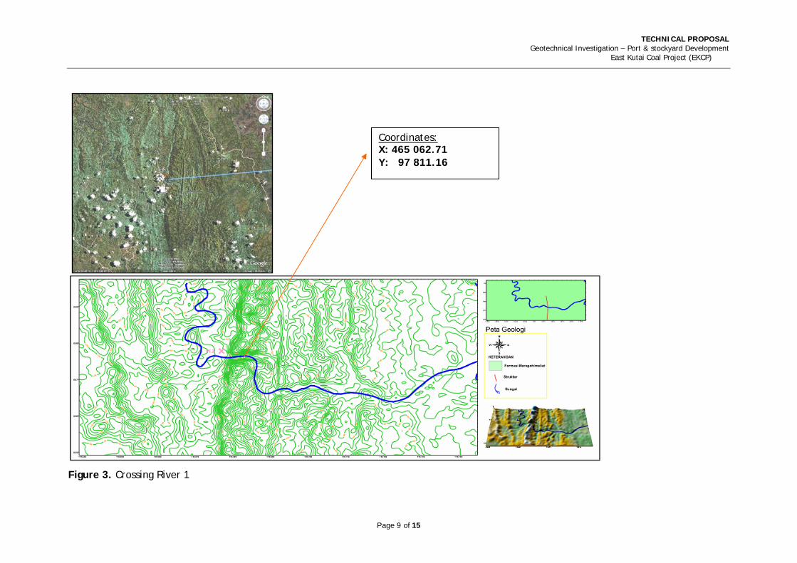
Coordinates: X: 465 062.71 Y: 97 811.16
Figure 3. Crossing River 1

TECHNICAL PROPOSAL Geotechnical Investigation – Bridge, Stockyard and Port Belt Conveyor Development
East Kutai Coal Project (EKCP)
Page 10 of 15
Coordinates: X: 485 574.14 Y: 99 634.29
Figure 4. Crossing River 2
TECHNICAL PROPOSAL Geotechnical Investigation – Bridge, Stockyard and Port Belt Conveyor Development
East Kutai Coal Project (EKCP)
Page 11 of 15
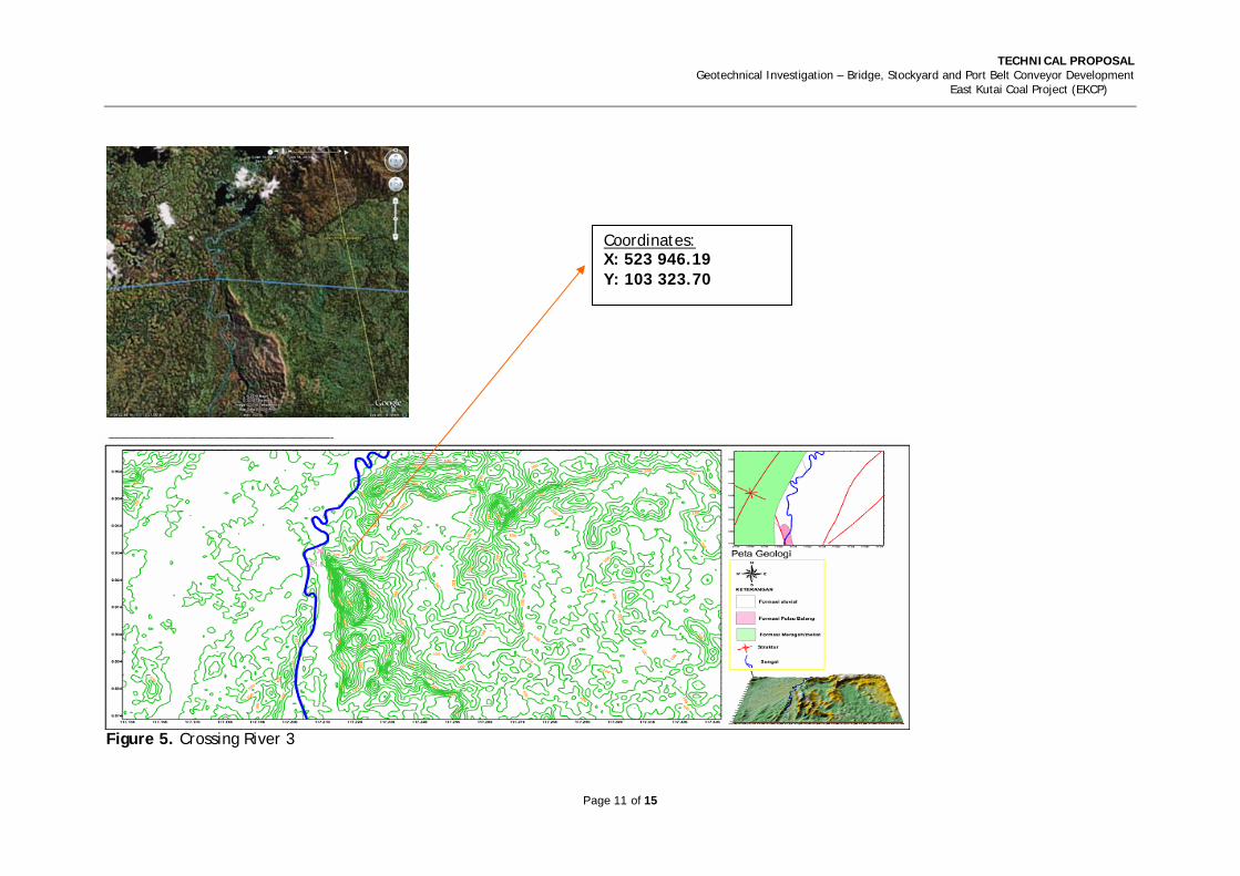
Coordinates: X: 523 946.19 Y: 103 323.70
Figure 5. Crossing River 3

TECHNICAL PROPOSAL Geotechnical Investigation – Bridge, Stockyard and Port Belt Conveyor Development
East Kutai Coal Project (EKCP)
Page 12 of 15
Figure 6. Lay Out of Geotechnical drilling & Cone Penetration Test (CPT) Investigation Plan at Bridge area

TECHNICAL PROPOSAL Geotechnical Investigation – Bridge, Stockyard and Port Belt Conveyor Development
East Kutai Coal Project (EKCP)
Page 13 of 15
Figure 7. CPT Plan and Geotechnical Drilling plan (1)
TECHNICAL PROPOSAL Geotechnical Investigation – Bridge, Stockyard and Port Belt Conveyor Development
East Kutai Coal Project (EKCP)
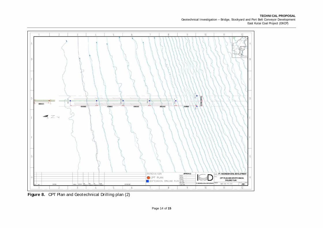
Figure 8. CPT Plan and Geotechnical Drilling plan (2)
Page 14 of 15
TECHNICAL PROPOSAL Geotechnical Investigation – Bridge, Stockyard and Port Belt Conveyor Development
East Kutai Coal Project (EKCP)
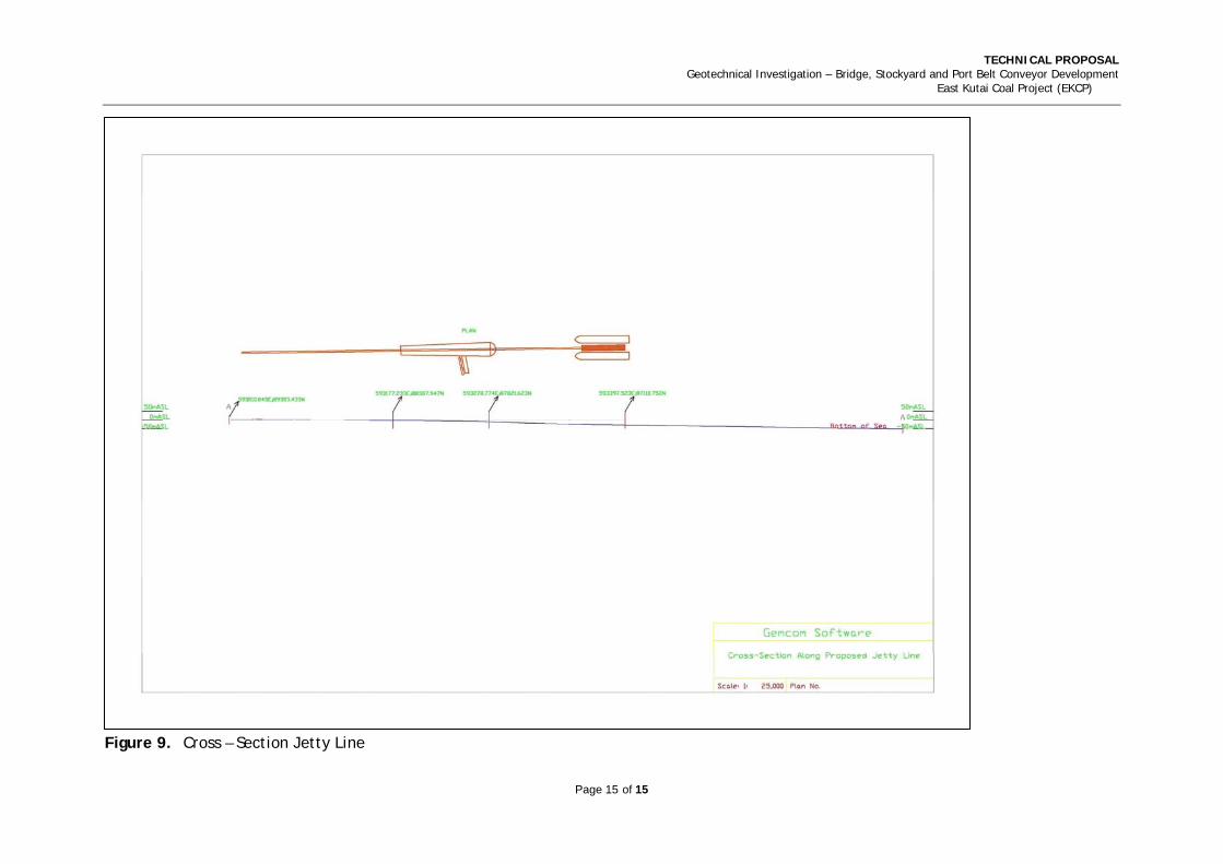
Figure 9. Cross – Section Jetty Line
Page 15 of 15

TECHNICAL PROPOSAL Geotechnical Investigation – Bridge, Stockyard and Port Belt Conveyor Development
East Kutai Coal Project (EKCP)
Page 16 of 15
Proposed Cost Estimate

TECHNICAL PROPOSAL Geotechnical Investigation – Bridge, Stockyard and Port Belt Conveyor Development
East Kutai Coal Project (EKCP)
Page 17 of 15
The study would take twelve (12) weeks dependant on the final agreed work scope and consist of the key activities below;
Proposed Time Schedule
TECHNICAL PROPOSAL Geotechnical Investigation – Port & stockyard Development
East Kutai Coal Project (EKCP)
Page 18 of 15
Project Control Systems DHV-MLD offers a project administration system that provides complete cost control functionality as well as a schedule interface that facilitates time and cost analysis. The administration system would be configured to match the requirements of the particular phase of the project. Project Controls during the Study
Due to the short duration and limited workspace, our usual approach of detailed progress and financial reports would be produced regularly to track progress on an “earned-value” basis against planned progress and costs would not be utilised. Earned value is a measure of the work actually completed based on the original estimate for that task. Estimates to complete are updated regularly by those responsible for the work in the Team.
Meeting the Schedule
The project schedule forms an integral part of the project control system. It is the benchmark against which earned value and progress are measured as the Study proceeds. The success of this program depends on good alignment with client’s needs, meeting early milestones, establishing the study basis and then rigorously driving tasks to planned completion dates. However, we would remain flexible and ready to respond to changing circumstances as the Study evolves. Any deviation to the work plan after the freeze period would potentially impact the study report release target date. Change Control
Changes to the plan are common in any study. The earlier that change factors are identified, the better the chance of being able to control and manage them and to mitigate the impacts. Identifying that something is in fact a change requires judgement and an evaluation against the current scope of work. A change register would be established to record changes to the project together with the management actions taken to address each change. Authorisation by the appropriate team leader and client would be required prior to the change being effected, however this would be a straightforward process of communication and coordination that would not slow the development pace of the Study.
Project Management System
The Study would use DHV-MLD’s proven Project Management system incorporating:
• Provision of timely and accurate cost and timing information to the project team in a format adequate to enable decision-making and intervention;
• Proactive identification of issues that may affect project time and cost.
• Key Performance Indicators (KPIs);
• Implementation of the project management system and other related and supporting systems;

TECHNICAL PROPOSAL Geotechnical Investigation – Bridge, Stockyard and Port Belt Conveyor Development
East Kutai Coal Project (EKCP)
Page 19 of 15
• Gathering of data from the project team and other sources to provide forecast and projections of project cost and time measures;
• Interface with and support other project discipline groups, and provide project control support to the package or area managers/leaders; and
• Provide concise, timely and accurate reporting to the project management team and the client.
Quality Assurance
DHV and our sub consultants are accredited or firmly committed to the quality management principals of ISO 9001:2000. To this end, we have established and refined our quality system and documentation in considerable detail. Study Specific Quality System
For this study, we would not develop a project specific quality plan but rather apply our general plan and principles due to the short nature and limited scope of the works. This plan in effect sets out the rules of the project and project specific document requirements. No Conflict of Interest
DHV-MLD confirms there is no Conflict of Interest with any of our other current assignments in Indonesia or the region.

TECHNICAL PROPOSAL Geotechnical Investigation – Bridge, Stockyard and Port Belt Conveyor Development
East Kutai Coal Project (EKCP)
Page 20 of 15
Commercial Proposal DHV-MLD proposal is subject to a mutually agreeable contract or service agreement being developed and executed which incorporates the basis of our proposal, terms and conditions as stated in this document and attachments.
Please refer to the breakdown of our commercial Proposal below. Essentially our fee is developed from an evaluation of the deliverables necessary for the task, the resources, mandays, and manhours required with support services and Sub-Consultants as necessary. This can be scaled up and down as required to meet ICD’s requirements.
Cost & Time Resources Approach
A Cost & Time Resource approach would be utilized where deliverables, personnel and rates are specified and then approved by the ICD. A target estimate is first developed based on the deliverables agreed to be developed. This approach also enables ready change to scope and level of detail as information is jointly reviewed during the process. Only hours worked for approved scope and deliverables are charged to the project.
Dependant on the final agreed deliverables and scope of work, DHV-MLD would determine the duration of the proposed study and thereby the cost. Initial indications would be of the order of ten (10) weeks for the Study as currently understood and dependant on the options developed.
Field plant and equipment other than as stated, is not included in our proposal. If third party services or equipment are required to be contracted through DHV-MLD, a 10% additional charge would be applied to their invoices and a variation to the contract price raised. Expenses incurred are cost plus 10%. Sampling rates included in schedule are estimated costs for plant & equipment subject to confirmation. If ICD provide potentially free of charge. All values within our proposal are in USD$ and are exclusive VAT.
Exchange rates are based on current publicly listed rates and would be invoiced at the current rate each month if applicable. This may apply to sub-consultants, materials and services by third parties and would be advised and confirmed prior to engagement.
DHV-MLD rates include all statutory requirements, salaries, provisions, medical, usual cost of employment for our personnel, insurance, and PPE as necessary to undertake their work and in line with industry standards.
DHV-MLD proposal is based on the information provided by ICD and assumptions as stated in this document. Final total costs would be based on ICD approved DHV-MLD timesheets and rates as stated in this proposal. Deviations may result in a variation to the workscope or time delay. Any observed deviations would be immediately advised and reviewed jointly with ICD to determine the best way forward; including minimizing potential cost and time

TECHNICAL PROPOSAL Geotechnical Investigation – Bridge, Stockyard and Port Belt Conveyor Development
East Kutai Coal Project (EKCP)
Page 21 of 15
impacts to progress the work (ie. significant rainfall and poor local conditions may affect duration of site visit once commenced).
Emergency situation/ evacuation (if occurs) during the site visit is ICD responsibility unless ICD advises DHV-MLD to assume this. In this event DHV-MLD would pass on any costs incurred if an incident arises and DHV-MLD emergency response system is utilized (Helicopter, plane & medical charges, etc where not otherwise covered).
Payment Terms
Initial payment of fifty (50) percent of estimated value, thirty (30) percent after submission of preliminary report, and twenty (20) percent at end of study


