162
273 3.2 Selection Assessment Documents for rRAs

273
3.2 Selection Assessment Documents for rRAs

274
MARINE CONSERVATION ZONE: SELECTION ASSESSMENT DOCUMENT
RRA A MUD HOLE
Version and issue date Amendments made
v1.0 August 2011
1. Site name
rRA A - Mud Hole
2. Site centre location
54° 20' 32.101" N, 3° 52' 34.138" W
54.34225 Lat, -3.876149 Long. Lambert Azimuthal Equal Area projection, ETRS89 datum
3. Site surface area
20.37Km2 ( 2036.62 Ha)
4. Biogeographic region
JNCC regional sea: Irish Sea.
OSPAR region III: Celtic Seas.
5. Features proposed for designation within rRA A
Feature type Feature name Area covered within site (for broad
scale habitats and habitats of
conservation importance)
Broad scale habitat A5.3 Subtidal mud 20.37 Km2 (2056.62 Ha)
Habitat of conservation
importance
Mud habitats in deep
water
Sea-pens and burrowing
megafauna communities
8.52 Km2 (852.22 Ha)
8.52 Km2 (852.22 Ha)
Species of conservation
importance
n/a
Geological feature n/a
Other feature n/a

275
6. Features within rRA: A not proposed for designation
Feature type Feature name Reason that feature has not been proposed
for designation
Broad scale
habitat
n/a
Habitat of
conservation
importance
n/a
Species of
conservation
importance
n/a

276
7. Map of site

277

278

279
8. Site summary
rRA A is situated within the northwest corner of rMCZ 1 some 24km off the coast of northwest England.
rRA A has a depth range of 50 -100m and captures part of the mud in deep water and sea-pens and
burrowing megafauna benthic habitats along the length of its eastern boundary. The mud habitat present
in rRA A forms part of the eastern Irish Sea mud patch, an area that is geographically isolated from the
deep water mud habitat that is present in the western Irish Sea (Clements 2010). This mud is of high
commercial interest, as it is the habitat of Nephrops norvegicus, the Dublin Bay prawn. There are, however,
a number of other species which inhabit this seabed type, including the brittlestar Amphiura chiajei and the
burrowing sea urchin Brissopsis lyrifera. Lumb et al. (2011) mapped the expected distribution of sea-pens
and burrowing megafauna within this part of the Irish Sea. The expected distribution was inferred from
survey data and from the presence of the suitable underlying habitat type (Hughes and Atkinson 1997).
Historically, sea-pens were abundant in this region (Jones et al. 1952 cited in Swift 1993), but relatively
recent video survey data indicated that they have become rare in this part of the eastern Irish Sea (Hughes
and Atkinson 1997). Designation of rRA A may allow for the potential recovery of sea-pens and burrowing
megafauna, a habitat type which is known to be vulnerable to otter trawl impacts (Hinz et al. 2009).
9. Detailed site description
rRA A is being recommended for designation for the presence of the broad-scale habitat type subtidal mud
and two characteristic sub-habitat features, mud habitats in deep water and sea-pens and burrowing
megafauna.
rRA A is located on the edge of a wider area of subtidal mud in the eastern Irish Sea. The habitat has been
mapped from a combination of both physical and biological data (UK Seamap, the Mapping European
Seabed Habitat projects (MESH). This area is subject to moderate energy wave and tidal energy (UK
SeaMap, 2010) and, as such, is a relatively stable, depositional environment.
To the south of rMCZ1, the biological community has been surveyed. From video surveys it appears that
the inshore the muddy sand community is characterised by a high abundance of bivalves Kurtiella
bidentata and brittle stars Amphiura filiformis, whilst the burrows present were characteristic of the
burrowing mud shrimp Callianassa subterranean (Walney and Ormonde 2009, 2010, & Lumb et al. 2011).
In contrast, offshore (where rMCZ1 is located) the predominant bivalves present were Mysella bidentata
and Abra nitida which are suspension and detritus feeders, respectively. Due to the low light levels no
plants tend to grow at this depth. This means that the marine invertebrates, found within the seabed are a
key part of the food chain, linking energy from the plankton to higher trophic levels, such as predatory fish
(Bolam et al. 2010).
There is survey data to verify the presence of the habitat features sea-pens and burrowing megafauna
within this wider area of subtidal mud. Lumb et al. (2011) reviewed previous survey data for the presence
of this habitat type and mapped the expected distribution of sea-pens and burrowing megafauna, including
the area of rMCZ1. It is important to note that the presence of sea-pens and burrowing megafauna within
the current boundaries of rMCZ1 is not confirmed from direct biological sampling, but inferred from their
presence in the surveyed mud to the south.
The most well known burrowing marine invertebrate that makes up the sea-pen and burrowing megafauna
habitat (and is also found in deep water mud habitats) is the Dublin Bay prawn Nephrops norvegicus. This
habitat corresponds with valuable commercial fishing grounds in this part of the project area. The eastern
280
Irish Sea Nephrops population is known to be smaller than the population in the western Irish Sea, which
occurs on a geographically separate mud patch. The two populations are not thought to be connected
larvally. (Clements 2010). There are, however, a suite of other animals which inhabit deep water mud
habitats including the brittlestar Amphiura chiajei and the burrowing sea urchin Brissopsis lyrifera.
These burrowing animals (including Nephrops) provide an important ecological function termed
bioturbation which refers to the disturbance and mixing of sediments by organisms especially by
burrowing, boring or ingestion. The activities of these animals, which can take many varied and species-
specific forms, leads to the disturbance of sediments on the seafloor. For example, suspension feeders such
as the burrowing mud shrimp Callianassa subterranean ingest the particles present within the sea water
that they draw into their burrows and the excreted material acts as a cement to form the rigid structure of
their burrow tubes; this provides stability to the sediment substrate (Kogure and Wada 2005).
10. Stakeholder and boundary considerations
In order to meet the ENG target, most stakeholders on the RSG accepted the inclusion of rRA A in the final
suite of Reference Areas. For a fuller context on the RSG discussions associated with the selection of
Reference Areas, readers of this report are encouraged to consult meeting reports from the ISCZ RSG
workshops held in May, June and July 2011 (ISCZ, 2011b,c,d).

281
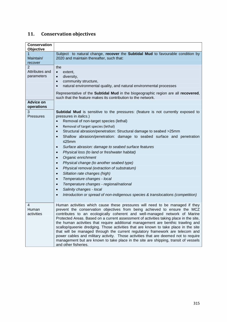
11. Conservation objectives
Conservation Objective
1 Maintain/ recover
Subject to natural change, recover the Subtidal Mud to reference condition by 2020 and maintain thereafter, such that:
2
Attributes and parameters
the
extent
diversity
community structure
natural environmental quality, and natural environmental processes
Representative of the Subtidal Mud in the biogeographic region are all recovered.
Advice on operations
3
Human activities
Reference areas should be managed to remove or prevent all extraction, deposition or potentially damaging activities.
Conservation Objective
1 Maintain/ recover
Subject to natural change, recover the Seapens and Burrowing Mega Fauna Communities to reference condition by 2020 and maintain thereafter, such that:
2
Attributes and parameters
the
extent
diversity
community structure
natural environmental quality, and natural environmental processes
Representative of the Seapens and Burrowing Mega Fauna Communities in the biogeographic region are all recovered.
Advice on operations
3
Human activities
Reference areas should be managed to remove or prevent all extraction, deposition or potentially damaging activities.
282
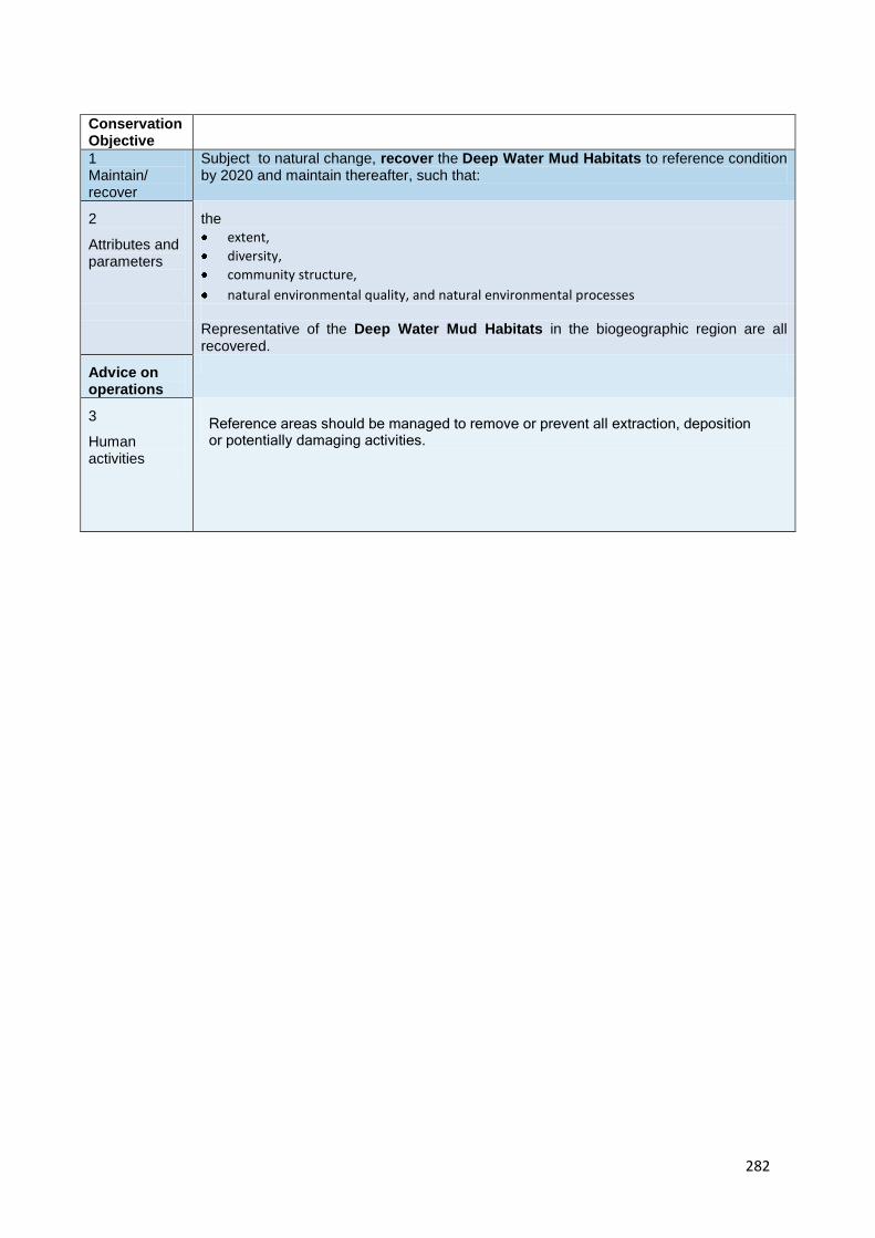
Conservation Objective
1 Maintain/ recover
Subject to natural change, recover the Deep Water Mud Habitats to reference condition by 2020 and maintain thereafter, such that:
2
Attributes and parameters
the
extent,
diversity,
community structure,
natural environmental quality, and natural environmental processes
Representative of the Deep Water Mud Habitats in the biogeographic region are all recovered.
Advice on operations
3
Human activities
Reference areas should be managed to remove or prevent all extraction, deposition or potentially damaging activities.

12. Sites to which this site is related
rRA A is located within rMCZ 1. The distance between rMCZ1 and other MCZs which are being
recommended for the designation of the same EUNIS level 2 habitat types was calculated. rMCZ1 is 15 km
(8 nm) from rMCZ2, 55 km (30 nm) from rMCZ8 and 77 km (41 nm) from rMCZ6. Like rMCZ1, these three
other MCZs have been recommended to protect sublittoral sediment.
rMCZ1 is in the vicinity of the following existing and draft conservation areas that have marine associated
features. Vicinity is in this context been defined as a distance less than 80 km. Morecambe Bay (SPA, SSSI),
Drigg coast (SAC) and Duddon estuary (SPA / SSSI) are within 40 km of rMCZ1. Within 80 km of this site are:
Solway Firth (SAC), Upper Solway flats and marshes (SPA), Luce Bay and Sands (SAC), Ribble and Alt
Estuaries (SPA).
13. Supporting documentation
Information Type of information Source
Location of subtidal mud Combined physical and
biological surveying with
habitat modelling
MESH
Location of mud habitats in
deep water
Combined physical and
biological surveying with
habitat modelling
MESH
Location of sea-pens and
burrowing megafauna
Inferred distribution based on
suitable habitat type, and
biological sampling.
Hughes and Atkinson 1997,
Lumb et al. 2011, Swift 1993
References
BOLAM, S.G., BARRIO-FROJAN, C.R.S. & EGGLETON, J.D. 2010. Macrofaunal production along the UK
continental shelf. Journal of Sea Research 64: 166-179.
CLEMENTS, A.J. 2010. Broad-scale ecological investigation of Nephrops norvegicus (L.) Burrow distribution
in the Western Irish Sea. Ph.D. Thesis, Queen's University Belfast.
HINZ, H., PRIETO, V. & KAISER, M.J. 2009. Trawl disturbance on benthic communities and chronic effects
and experimental predictions. Ecological Applications 19 (3) 761-773.
HUGHES, D.J. & ATKINSON, R.J.S. 1997. Towed video survey of the megafaunal bioturbation in the North
Eastern Irish Sea. Journal of the Marine Biological Association. 77 635-653.
ISCZ. 2011b. Meeting report from the 6th Irish Sea Conservation Zones Stakeholder Group meeting. RK
Partnership Ltd.
ISCZ. 2011c. Meeting report from the 7th Irish Sea Conservation Zones Stakeholder Group meeting. RK
Partnership Ltd.

284
ISCZ. 2011d. Meeting report from the 8th Irish Sea Conservation Zones Stakeholder Group meeting. RK
Partnership Ltd.
LUMB, C. 2011. Evidence on the distribution and quality of mud-related features in the Eastern Irish Sea. A
paper presented to the ISCZ Project Team and Regional Stakeholder Group.
KOGURE, K., AND WADA, M. 2005. Impacts of macrobenthic bioturbation in marine sediment on bacterial
metabolic activity. Microbes and Environments 20 (4) 191-199.
SWIFT, D.J. 1993. The macrobenthic infauna off Sellafield (north-eastern Irish Sea) with special reference to
bioturbation. Journal of the Marine Biological Association, 73, 143-162.
WALNEY & ORMONDE. 2009. Offshore Windfarm Benthic Survey Reports November 2009 & October 2010.
Work undertaken for Dong Energy/Vattenfall by CMACS

285
MARINE CONSERVATION ZONE: SELECTION ASSESSMENT DOCUMENT
RRA B NORTH ST. GEORGE’S CHANNEL (1)
Version and issue date Amendments made
v1.0 August 2011
1. Site name
rRA - B North St. George’s Channel (1)
2. Site centre location
53° 30' 59.584" N, 4° 56' 38.815" W
53.516551 Lat, -4.944115 Long. Lambert Azimuthal Equal Area projection, ETRS89 datum
3. Site surface area
35.28 Km2 ( 3528.29 Ha)
4. Biogeographic region
JNCC regional sea: Irish Sea.
OSPAR region III: Celtic Seas.
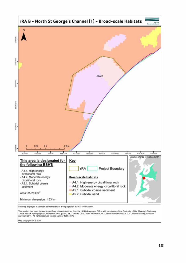
5. Features proposed for designation within rRA B
Feature type Feature name Area covered within site (for broad
scale habitats and habitats of
conservation importance)
Broad scale habitat A4.1 High energy
circalittoral rock
A4.2 Moderate energy
circalittoral rock
A5.1 Subtidal coarse
sediment
8.63 Km2 (862.84 Ha)
22.73 Km2 (2272.85 Ha)
3.93 Km2 (392.61 Ha)
Habitat of conservation
importance
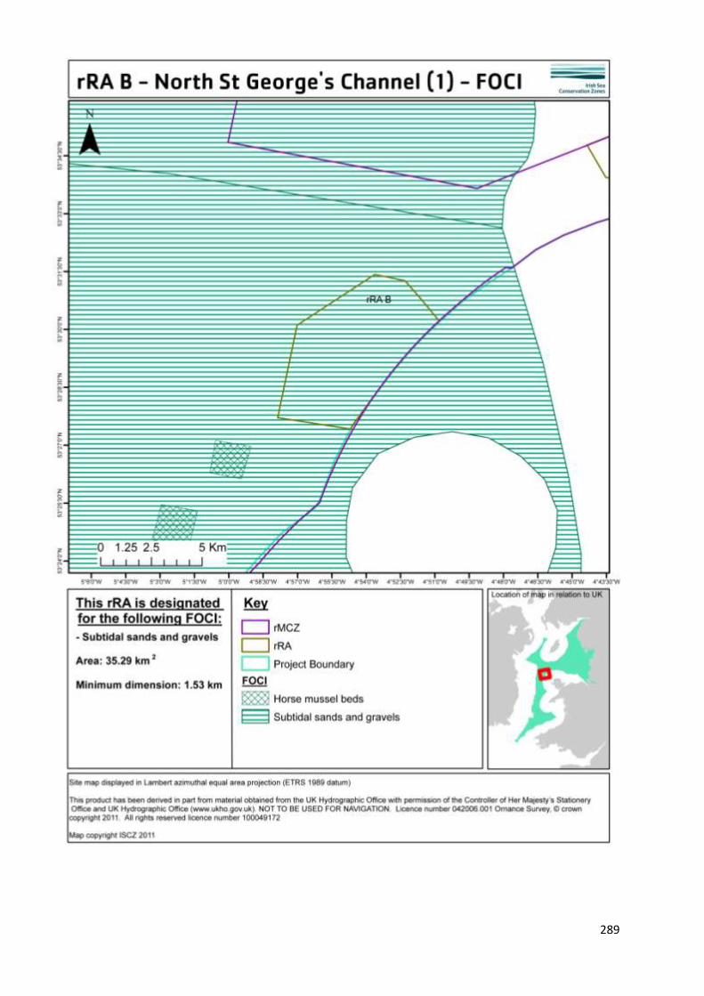
Subtidal sands and gravels 35.28 Km2 (3528.29 Ha)
Species of conservation
importance
n/a
Geological feature n/a
Other feature n/a

286
6. Features within rRA B not proposed for designation
Feature type Feature name Reason that feature has not been proposed
for designation
Broad scale
habitat
n/a
Habitat of
conservation
importance
n/a
Species of
conservation
importance
n/a

287
7. Map of site
288
289

290
8. Site summary
rRA B is situated within rMCZ 3. It is a small area in the mid-Irish Sea and it is located approximately 23 km /
12 nm off the coast of Anglesey in Wales. The depth of the area ranges from 50 to 100 m.
rRA: B has been identified as an Annex I reef habitat listed on the EU Habitats and Species directive, and
forms part of the North-West Anglesey reef complex. These reefs are comprised of both high and
moderate energy circalittoral rock, which are being recommended for designation. Such reefs are
comprised of stable boulders and cobbles that create a habitat that can readily be colonised by a varied
plant and animal community. Surveys of rRA: B found the area to be broadly characterised by a complex
topography with mixed coarse sediments, which are home to tide swept communities in deep water which
is one of only two examples within the ISCZ project area.
9. Detailed site description
r RA B is a small area 35.28 Km2 ( 3528.29 Ha) situated in the north eastern aspect of rMCZ3, the largest of
the recommended marine conservation zones in the Irish Sea. rRA: B captures both high and moderate
energy circalittoral rock, or bedrock on the seafloor which is subject to a high to moderate level of wave
and tidal energy (MESH). Parts of these areas of bedrock have been surveyed to verify the presence of
specific Annex I reef habitat, listed on the EU Habitats and Species directive. The area within rRA: B is part
of the wider North-West Anglesey reef complex. Such rocky reefs occur where the bedrock or stable
boulders and cobbles arise from the surrounding seabed creating a habitat that is colonised by many
different marine animals and plants. Rocky reefs can be very variable in terms of both their structure and
the communities that they support. (Irving, 2009)
Biological and acoustic surveys carried out by JNCC indicated that reef forming boulders and cobbles are
present in rRA: B and are home to a variety of animal species such as the opportunistic tube worm
Pomatoceros triquete that encrusts onto hard substrates such as rock; the soft coral, dead man’s fingers
Alcyonium digitatum which attaches where otherwise dominant algae are unable to grow, they are also
closely associated with prevailing strong water movement. Horn wrack Flustra foliacea along with hydroids,
such as Abietinaria abietin were also identified on such wave exposed circalittoral rock habitats. Along
video tows, the reef habitat tended to alternate with more gravelly areas of non-reef habitat. (Blyth-
Skyrme et al. 2008). Subtidal coarse sediments are also recommended for designation as are the HOCI
subtidal sands and gravels that fall within the boundary limits of rRA: B.
The seabed in rMCZ3 has also been mapped using a combination of physical and biological data (UK
Seamap, the Mapping European Seabed Habitat projects (MESH), and the HABMAP project). The
predominant broad-scale habitat types present in the area are the three which constitute the habitat
feature subtidal sands and gravels. In this region, sands and gravels are mainly shell derived (Maddock
2010) and support an abundance of bivalves and polychaete worms. Bolam et al. (2010) identified molluscs
and annelid worms which live within the sediment as the main secondary producers in this part of the Irish
Sea. These invertebrates are a key part of the food chain, as they recycle organic matter from within the
sediment, linking primary production from the plankton to predatory fish, they are able to unlock the
energy of primary producers, which in the sea are the phytoplankton (microscopic algae), and make it
available to be used as food by other creatures. As such, primary producers are the very basis of the food
chain that provides the fish that humans consume. (Bolam et al. 2010).

291
10. Stakeholder and boundary considerations
In order to meet the ENG target, most stakeholders on the RSG accepted the inclusion of rRA B in the final
suite of Reference Areas. For a fuller context on the RSG discussions associated with the selection of
Reference Areas, readers of this report are encouraged to consult meeting reports from the ISCZ RSG
workshops held in May, June and July 2011 (ISCZ, 2011b,c,d).

292
11. Conservation objectives
Conservation Objective
1 Maintain/ recover
Subject to natural change, recover the High Energy Circalittoral Rock to reference condition by 2020 and maintain thereafter, such that:
2
Attributes and parameters
the
extent,
diversity,
community structure,
natural environmental quality*, and natural environmental processes*
Representative of the High Energy Circalittoral Rock in the biogeographic region are all recovered.
Advice on operations
3
Human activities
Reference areas should be managed to remove or prevent all extraction, deposition or potentially damaging activities.
Conservation Objective
1 Maintain/ recover
Subject to natural change, recover the Moderate Energy Circalittoral Rock to reference condition by 2020 and maintain thereafter, such that:
2
Attributes and parameters
the
extent,
diversity,
community structure,
natural environmental quality*, and natural environmental processes*
Representative of the Moderate Energy Circalittoral Rock in the biogeographic region are all recovered.
Advice on operations
3
Human activities
Reference areas should be managed to remove or prevent all extraction, deposition or potentially damaging activities.

293
Conservation Objective
1 Maintain/ recover
Subject to natural change, recover the Subtidal Coarse Sediment to reference condition by 2020 and maintain thereafter, such that:
2
Attributes and parameters
the
extent,
diversity,
community structure,
natural environmental quality*, and natural environmental processes*
Representative of the Subtidal Coarse Sediment in the biogeographic region are all recovered.
Advice on operations
3
Human activities
Reference areas should be managed to remove or prevent all extraction, deposition or potentially damaging activities.
Conservation Objective
1 Maintain/ recover
Subject to natural change, recover the Subtidal Sands and Gravels to reference condition by 2020 and maintain thereafter, such that:
2
Attributes and parameters
the
extent,
diversity,
community structure,
natural environmental quality*, and natural environmental processes*
Representative of the Subtidal Sands and Gravels in the biogeographic region are all recovered.
Advice on operations
3
Human activities
Reference areas should be managed to remove or prevent all extraction, deposition or potentially damaging activities.

12. Sites to which this site is related
rRA B is located in rMCZ 3 in the mid-Irish sea, 88 km (47 nm) to the north of another recommended MCZ
(rMCZ4), 80 km (43 nm) from the Lleyn Peninsula and the Sarnau (a Welsh inshore Special Area of
Conservation (SAC) with marine components, including horse mussel beds and ross worm Sabellaria
spinulosa reefs) and 35 km (19 nm) from the Menai Strait and Conwy Bay another Welsh inshore SAC with
marine components).
13. Supporting documentation
Information Type of information Source
Location of high energy
circalittoral rock
Combined physical and
biological surveying with
habitat modelling
Robinson et al. (2007), MESH,
Blyth-Skyrme et al. 2008
Location of moderate energy
circalittoral rock
Combined physical and
biological surveying with
habitat modelling
Robinson et al. (2007), MESH,
Blyth-Skyrme et al. 2008
Subtidal coarse sediment Combined physical and
biological surveying with
habitat modelling
Robinson et al. (2007), MESH.
Subtidal sand
Combined physical and
biological surveying with
habitat modelling
Robinson et al. (2007), MESH.
Subtidal sands and gravels Combined physical and
biological surveying with
habitat modelling
Robinson et al. (2007), MESH.
References
BLYTH-SKYRME, V. LINDENBAUM, C., VERLING, E., VAN LANDEGHEM, K., ROBINSON, K., MACKIE A., &
DARBYSHIRE T. 2008. Broad-scale biotope mapping of potential reefs in the Irish Sea (north-west of
Anglesey) JNCC Report No. 423.
BOLAM, S.G., BARRIO-FROJAN, C.R.S. & EGGLETON, J.D. 2010. Macrofaunal production along the UK
continental shelf. Journal of Sea Research 64: 166-179.
IRVING, R. 2009. The identification of the main characteristics of stony reef habitats under the
Habitats Directive. Summary report of an inter-agency workshop 26-27 March 2008. JNCC
Report No. 432
ISCZ. 2011b. Meeting report from the 6th Irish Sea Conservation Zones Stakeholder Group meeting. RK
Partnership Ltd.
ISCZ. 2011c. Meeting report from the 7th Irish Sea Conservation Zones Stakeholder Group meeting. RK
Partnership Ltd.

295
ISCZ. 2011d. Meeting report from the 8th Irish Sea Conservation Zones Stakeholder Group meeting. RK
Partnership Ltd.
MADDOCK, A. 2010. UK Biodiversity Action Plan; Priority Habitat Descriptions. BRIG (ed. Ant
http://www.ukbap.org.uk/library/UKBAPPriorityHabitatDescriptionsRevised20100730.pdf

296
MARINE CONSERVATION ZONE: SELECTION ASSESSMENT DOCUMENT
RRA C MID ST GEORGE’S CHANNEL
Version and issue date Amendments made
v1.0 August 2011
1. Site name
rRA C - Mid St. George’s Channel
2. Site centre location
52° 37' 32.293" N, 5° 22' 54.816" W
52.625636 Lat, -5.381893 Long. Lambert Azimuthal Equal Area projection, ETRS89 datum
3. Site surface area
103.45 Km2 (10344.83 Ha)
4. Biogeographic region
JNCC regional sea: Irish Sea.
OSPAR region III: Celtic Seas.
5. Features proposed for designation within rRA C
Feature type Feature name Area covered within site (for broad
scale habitats and habitats of
conservation importance)
Broad scale habitat A4.2 Moderate energy
circalittoral rock
A5.1 Subtidal coarse
sediment
A5.2 Subtidal sand
A5.4 Subtidal mixed
sediments
21.16 Km2 (2116.13 Ha)
34.80 Km2 (3480.12 ha)
1.04 Km2 (103.69 Ha)
46.46 km2 (4644.99 Ha)
Habitat of conservation
importance
Subtidal sands and gravels 103.45 Km2 (10344.73 Ha)
Species of conservation
importance
n/a
Geological feature n/a
Other feature n/a

297
6. Features within rRA C not proposed for designation
Feature type Feature name Reason that feature has not been
proposed for designation
Broad scale
habitat
n/a
Habitat of
conservation
importance
n/a
Species of
conservation
importance
n/a
298
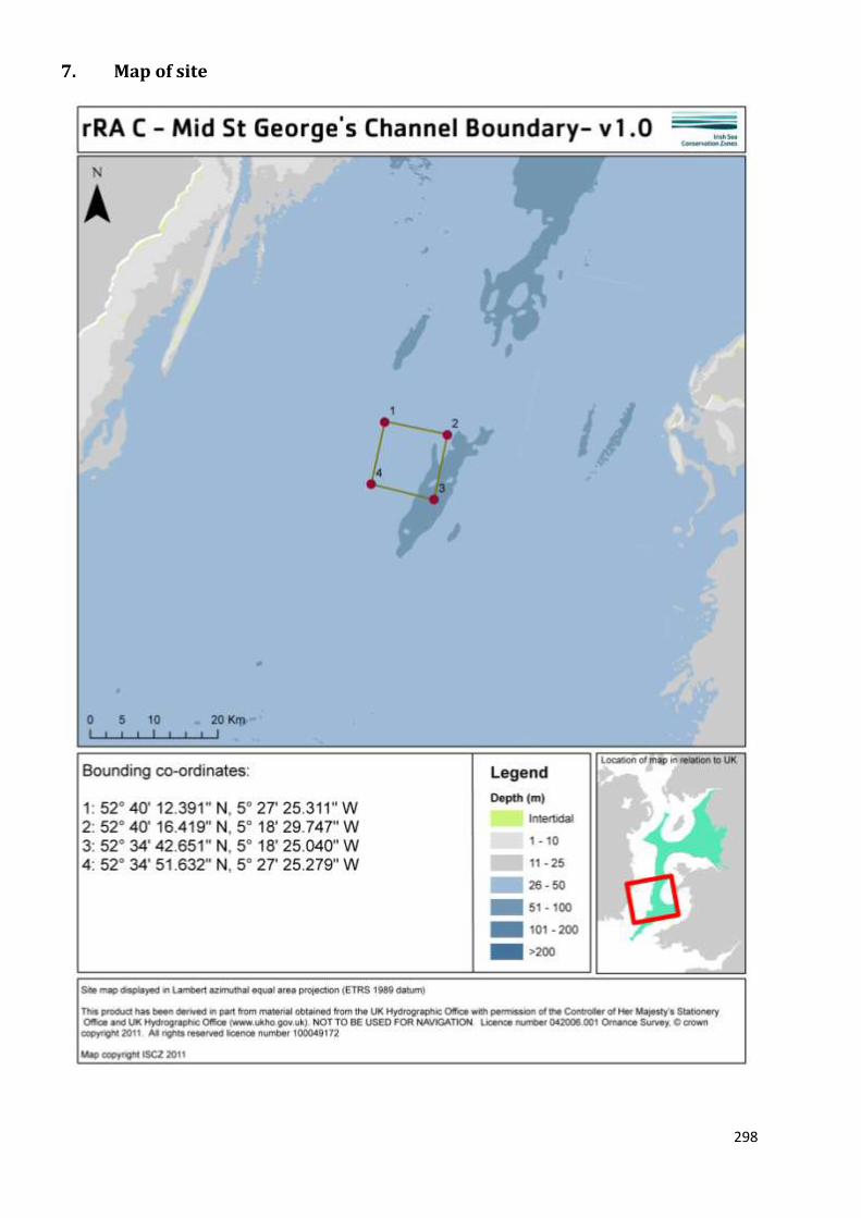
7. Map of site

299

300

301
8. Site summary
rRA C is located within the south west region of rMCZ 4 in the offshore waters of the Irish Sea, c.40 km
from the coast of Wales. It is situated between Irish offshore waters to the west and Welsh territorial
waters to the east. The depth of the site ranges from 50 – 100 m. The seabed type is predominantly
subtidal coarse sediment, but there are also areas of subtidal mixed sediments, sand and bedrock, which is
potentially reef habitat (Dalkin 2008). Due to the thermal fronts that form in the summer months, this is
an area of relatively high biological productivity (Miller et al. 2010). This highlights the importance of this
site for general ecosystem processes, as an increase in primary production attracts herbivorous species
and, in turn, larger marine predators to the area. Within the subtidal sands and gravel habitat in this area,
annelid worms, bivalves and crustaceans are the main secondary producers. These invertebrates provide
an essential link in energy flow within the ecosystem, recycling organic matter in the sediment, linking
primary production to predatory fish (Bolam et al. 2010).
9. Detailed site description
A combination of physical and biological surveys have been used to identify the seabed habitat types
within the area (UKSeaMap: Connor et al. 2006, the Mapping European Seabed Habitat projects (MESH),
and HABMAP: Robinson et al. 2007). The predominant marine habitat type in rRA C is subtidal mixed
sediment, amongst which are smaller areas of coarse sediment sand, and bedrock. A JNCC commissioned
survey collected data from around this region to verify the presence of potential reef habitat amongst the
areas of rocky habitat (Dalkin 2008). From the JNCC survey, technical issues precluded video and still
photographs from being collected of the seabed and therefore the presence of reef habitat within site
rMCZ4 and therefore rRA C has not been verified through biological sampling. However, inferences on the
biological community in rRA C can be drawn from the shared broad-scale habitat type (moderate energy
circalittoral rock, or subtidal bedrock) that was successfully surveyed to the north of the site within rRA 4.
The subtidal bedrock, namely cobbles and boulders was the reef habitat surveyed to the north of the site.
This habitat is of ecological importance because it supports a diverse animal community. Barnacles and
worms, including Pomatoceros triqueter were found within the offshore circalittloral coarse sediment ,
whilst the subtidal mixed sediments contained pebbles, cobbles and boulders that were home to a diverse
range of fauna, including barnacles, hydroids, anemones and sponges, for example, dead man’s fingers
(Dalkin et al. 2008; Figure 1).
Sand and gravel sediments are the most common habitat types found in the site and these are host a range
of different invertebrate species. Within and around rRA C annelids, worms and crustacean species are the
main secondary producers in the food web (Bolam et al. 2010). These species, which live within or on the
seabed, play a key role in recycling organic matter within the sediment, and linking the primary production
(in the plankton) with predatory fish.
In addition, this site covers an area of high primary productivity, due to the thermal fronts which commonly
form in this location (Miller et al. 2010). An increase in solar energy during spring causes the relatively
warm, less dense, water to sit on top of colder, denser, deep water. This increase in temperature triggers
an increase in biological productivity, similar to the increase in productivity later on in the year when water
cooling allows for nutrient rich deeper waters coming in from the Atlantic to mix with the surface waters
(Brown et al. 2010).

302
Figure 1. Silty cobbles and boulders with gravel and sand surveyed to the north of rRA C. These habitat
types are home to barnacles, hydroids, anemones and dead man’s fingers (Image taken from Dalkin 2008).
10. Stakeholder and boundary considerations
In order to meet the ENG target, most stakeholders on the RSG accepted the inclusion of rRA C in the final
suite of Reference Areas. For a fuller context on the RSG discussions associated with the selection of
Reference Areas, readers of this report are encouraged to consult meeting reports from the ISCZ RSG
workshops held in May, June and July 2011 (ISCZ, 2011b,c,d).
This site was included in the first iteration to capture the large amount of subtidal mixed sediments in the
project area. Its boundary has changed very little since the first iteration but, most recently, it’s southern
boundary has been altered slightly so that there is relatively little overlap with Belgian beam trawl activity.

303
11. Conservation objectives
Conservation Objective
1 Maintain/ recover
Subject to natural change, recover the Subtidal Mixed Sediment to reference condition by 2020 and maintain thereafter, such that:
2
Attributes and parameters
the
extent,
diversity,
community structure,
natural environmental quality, and natural environmental processes
Representative of the Subtidal Mixed Sediment in the biogeographic region are all recovered.
Advice on operations
3
Human activities
Reference areas should be managed to remove or prevent all extraction, deposition or potentially damaging activities.
Conservation Objective
1 Maintain/ recover
Subject to natural change, recover the Moderate Energy Circalittoral Rock to reference condition by 2020 and maintain thereafter, such that:
2
Attributes and parameters
the
extent,
diversity,
community structure,
natural environmental quality, and natural environmental processes
Representative of the Moderate Energy Circalittoral Rock in the biogeographic region are all recovered.
Advice on operations
3
Human activities
Reference areas should be managed to remove or prevent all extraction, deposition or potentially damaging activities.
304
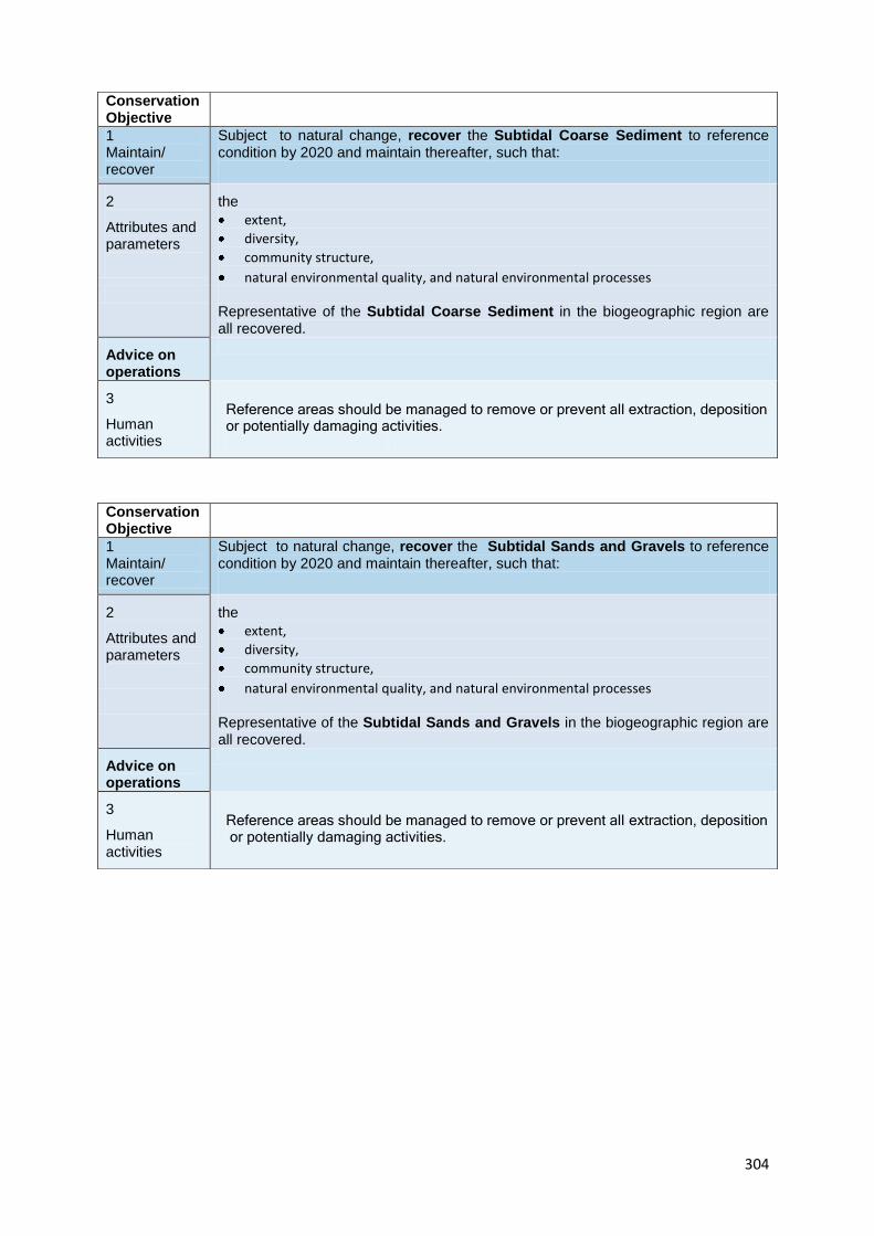
Conservation Objective
1 Maintain/ recover
Subject to natural change, recover the Subtidal Coarse Sediment to reference condition by 2020 and maintain thereafter, such that:
2
Attributes and parameters
the
extent,
diversity,
community structure,
natural environmental quality, and natural environmental processes
Representative of the Subtidal Coarse Sediment in the biogeographic region are all recovered.
Advice on operations
3
Human activities
Reference areas should be managed to remove or prevent all extraction, deposition or potentially damaging activities.
Conservation Objective
1 Maintain/ recover
Subject to natural change, recover the Subtidal Sands and Gravels to reference condition by 2020 and maintain thereafter, such that:
2
Attributes and parameters
the
extent,
diversity,
community structure,
natural environmental quality, and natural environmental processes
Representative of the Subtidal Sands and Gravels in the biogeographic region are all recovered.
Advice on operations
3
Human activities
Reference areas should be managed to remove or prevent all extraction, deposition or potentially damaging activities.

305
Conservation Objective
1 Maintain/ recover
Subject to natural change, recover the Subtidal Sands to reference condition by 2020 and maintain thereafter, such that:
2
Attributes and parameters
the
extent,
diversity,
community structure,
natural environmental quality, and natural environmental processes
Representative of the Subtidal Sands in the biogeographic region are all recovered.
Advice on operations
3
Human activities
Reference areas should be managed to remove or prevent all extraction, deposition or potentially damaging activities.
12. Sites to which this site is related
rRA C is located within the south west region of rMCZ 4. rMCZ 4 is placed between two other
recommended MCZs in the Irish Sea Conservation Zone region, rMCZ 5 which is 75 km (40 nm) to the south
and rMCZ 3 which is 88 km (47 nm) to the north. All three of these sites are offshore and have been
recommended to protect the EUNIS level 2 habitat types, sublittoral sediment and circalittoral rock.
There are two Welsh marine Special Areas of Conservation (SAC) in the vicinity of rMCZ4 (vicinity being
defined as less than 80 km). Lleyn Peninsula and the Sarnau, a marine SAC is within 50 km (27 nm) while
the SAC in Cardigan Bay is 65 km (35 nm) away. There are also four Irish Natura 2000 sites in the vincinity
of rMCZ 4: Long Bank is 57 km away, Carnsore Point 61 km away, Saltee Islands 47 km away and Wicklow
Reef SAC 37km away.
13. Supporting documentation
Information Type of information Source
Location of moderate energy
circalittoral rock
Combined biological and
physical data were used to
generate predictive habitat
maps of the seabed
Connor et al. 2006, MESH
project, Robinson et al. 2007
Location of subtidal coarse
sediment
Combined biological and
physical data were used to
generate predictive habitat
maps of the seabed
Connor et al. 2006, MESH
project, Robinson et al. 2007
Location of subtidal sand Combined biological and
physical data were used to
generate predictive habitat
maps of the seabed
Connor et al. 2006, MESH
project, Robinson et al. 2007
Location of subtidal mixed
sediments
Combined biological and
physical data were used to
generate predictive habitat
maps of the seabed
Connor et al. 2006, MESH
project, Robinson et al. 2007
Location of subtidal sands and
gravels
Combined biological and
physical data were used to
generate predictive habitat
maps of the seabed
Connor et al. 2006, MESH
project, Robinson et al. 2007
307
References
BOLAM, S.G., BARRIO-FROJAN, C.R.S. & EGGLETON, J.D. 2010. Macrofaunal production along the UK
continental shelf. Journal of Sea Research 64: 166-179.
BROWN, J., CARILLO, L., FERNAND, L., HORSBURGH, K.J., HILL, A.E., YOUNG, E.F. & MEDLER, K.J. 2003.
Observations on the physical structure and the seasonal jet-like circulation of the Celtic Sea and St George’s
Channel of the Irish Sea. Continental Shelf Research 23: 533-561.
CONNOR, D.W., GILLILAND, P.M., GOLDING, N., ROBINSON,P., TODD, D., & VERLING, E. 2006. UKSeaMap:
themapping of seabed and water column features of UK seas. Joint Nature Conservation Committee.
DALKIN, M. 2008. Mid Irish Sea reefs habitat mapping report, JNCC Report 411, ISSN 0963 8901
ISCZ. 2011b. Meeting report from the 6th Irish Sea Conservation Zones Stakeholder Group meeting. RK
Partnership Ltd.
ISCZ. 2011c. Meeting report from the 7th Irish Sea Conservation Zones Stakeholder Group meeting. RK
Partnership Ltd.
ISCZ. 2011d. Meeting report from the 8th Irish Sea Conservation Zones Stakeholder Group meeting. RK
Partnership Ltd.
MESH Mapping European Seabed Habitats. Available at http://www.searchMESH.net [Accessed on 16th
May 2011]
MILLER, P.I., CHRISTODOULOU, S. & SAUX-PICART, S. 2010. Oceanic thermal fronts from Earth observation
data – a potential surrogate for pelagic diversity. Report to the Department of Environment, Food and
Rural Affairs. Defra Contract No. MB102. Plymouth Marine Laboratory, subcontracted by ABPmer, Task 2F,
pp. 24.
ROBINSON, K., RAMSAY, K., WILSON, J., MACKIE A., WHEELER, A., O’BEIRN F., LINDENBAUM, C., VAN
LANDEGHAM, K., MCBREEN, F., MITCHELL, N. 2007. HABMAP:Habitat Mapping for conservation and
management of the southern Irish Sea. Report to the Welsh European Funding Office. CCW Science Report
Number
810. Countryside Council for Wales, Bangor. 233 pp plus appendices.

308
MARINE CONSERVATION ZONE: SELECTION ASSESSMENT DOCUMENT
RRA F SOUTH RIGG
Version and issue date Amendments made
v1.0 August 2011
1. Site name
rRA F - South Rigg
2. Site centre location
54° 24' 43.772" N, 4° 54' 13.501" W
54.412158 Lat, -4.90375 Long. Lambert Azimuthal Equal Area projection, ETRS89 datum
3. Site surface area
15.82 Km2 (1581.64 Ha)
4. Biogeographic region
JNCC regional sea: Irish Sea.
OSPAR region III: Celtic Seas.
5. Features proposed for designation within rRA F
Feature type Feature name Area covered within site (for broad
scale habitats and habitats of
conservation importance)
Broad scale habitat A5.2 Subtidal sand
A5.3 Subtidal mud
15.44 Km2 (1544.26 Ha)
0.37 Km2 ( 37.38 Ha)
Habitat of conservation
importance
Sea-pen and burrowing
megafauna communities
-
Species of conservation
importance
Ocean quahog Arctica
islandica
-
Geological feature
Other feature

309
6. Features within rRA F not proposed for designation
Feature type Feature name Reason that feature has not been proposed
for designation
Broad scale
habitat
n/a
Habitat of
conservation
importance
n/a
Species of
conservation
importance
n/a

310
7. Map of site

311

312

313
8. Site summary
rRA F is located in the north eastern corner of rMCZ 6, in the western Irish Sea between three different
territorial seas - northern Irish waters to the west, Scottish waters to the north and the Isle of Man waters
to the east. The depth of the seabed in the site ranges from 50 to 100 m.
Adjacent to the NW Irish Sea mounds and subtidal mud area within rMCZ 6, rRA F is located in the most
northerly patch of subtidal sand in the ISCZ project area. The ocean quahog, Arctica islandica occurs in this
area of subtidal sand (Butler 2009). Live juveniles have been recorded within rRA F and are indicative of a
breeding population (Butler pers comm. 2011). rRA F therefore represents the only region of known
breeding quahogs within the Irish Sea Conservation Zone project area.
9. Detailed site description
rRA F is located in the north-west of the Irish Sea. The habitat data for rRA F stems from the MESH project
(Mapping European Seabed Habitats) which includes a JNCC commissioned survey, undertaken by the AFBI
(Agri-Food and Biosciences, Northern Ireland).
rRA F is predominantly comprised of the broadscale habitat subtidal sand. This area is known to be highly
productive. The infaunal community of species present is relatively diverse and ranges from echinoderms
such as sea potato Echinocardium cordatum, brittlestar Amphiura filiformis, shrimp like crustaceans
Mysidea spp, and bivalves. There is also a large Annelid worm population (AFBI, unpublished data. Service
pers. comm. 2011). Bolam et al. (2010) identified molluscs (bivalves) and annelid worms which live within
the sediment as the main secondary producers in this part of the Irish Sea. These invertebrates are a key
part of the food chain; they recycle organic matter from within the sediment, linking primary production
from the plankton to predatory fish (Bolam et al. 2010).
Within this site the ocean quahog Arctica islandica has been recorded (Butler, 2009). The ocean quahog is a
long-lived bivalve which, like trees, deposits an annual growth ring, the width of which can be used as a
proxy for palaeoenvironmental conditions. Its shell material is therefore an important palaeoclimatic tool
that can be used to study the history of changes in sea temperature and other marine environmental
variables on multi-centennial timescales (Butler 2009). In addition, breeding populations of quahogs are
not generally found in the Irish Sea (possibly because the warmer seawater temperatures in recent years
do not favour larval survival). Juvenile quahogs have, however, been collected in the subtidal sand patch
within rRA F, making this possibly the only breeding population of this important species in the ISCZ project
area (Butler pers comm. 2011).
With the exception of localised areas around the bedrock, there are slow tidal currents around rMCZ6 (and
in this area in general: 0.3 m s-1, compared to 1 m s-1 in the Eastern Irish Sea; Horsburgh et al. 2000). These
deep water, low energy conditions lead to a seasonal stratification in the water column, where during
spring and summer there is not enough tidal energy to vertically mix the cold deep water with the warmer
surface waters (Brown et al. 2000). This results in a density driven cyclonic gyre (i.e. a vortex or rotating
body of water) during summer and spring, which physically entrains Nephrops and pelagic juvenile fish
larvae within the western Irish Sea gyre (Horsburgh et al. 2000).
CEFAS undertook the Defra MB5301 contract to map spawning and nursery grounds of selective fish
species for spatial planning. Within rRA F Herring Clupea harengus, Whiting Merlangius merlangus and

314
Spurdog Squalus acanthias were found to be in high intensity of both spawning and nursery grounds.
Therefore, designation of rRA F may help further protect these resources.
10. Stakeholder and boundary considerations
In order to meet the ENG target, most stakeholders on the RSG accepted the inclusion of rRA F in the final
suite of Reference Areas. For a fuller context on the RSG discussions associated with the selection of
Reference Areas, readers of this report are encouraged to consult meeting reports from the ISCZ RSG
workshops held in May, June and July 2011 (ISCZ, 2011b,c,d).
315
11. Conservation objectives
Conservation Objective
1 Maintain/ recover
Subject to natural change, recover the Subtidal Mud to favourable condition by 2020 and maintain thereafter, such that:
2 Attributes and parameters
the
extent,
diversity,
community structure,
natural environmental quality, and natural environmental processes
Representative of the Subtidal Mud in the biogeographic region are all recovered, such that the feature makes its contribution to the network.
Advice on operations
3 Pressures
Subtidal Mud is sensitive to the pressures: (feature is not currently exposed to pressures in italics.)
Removal of non-target species (lethal)
Removal of target species (lethal)
Structural abrasion/penetration: Structural damage to seabed >25mm
Shallow abrasion/penetration: damage to seabed surface and penetration
≤25mm
Surface abrasion: damage to seabed surface features
Physical loss (to land or freshwater habitat)
Organic enrichment
Physical change (to another seabed type)
Physical removal (extraction of substratum)
Siltation rate changes (high)
Temperature changes - local
Temperature changes - regional/national
Salinity changes - local
Introduction or spread of non-indigenous species & translocations (competition)
4 Human activities
Human activities which cause these pressures will need to be managed if they prevent the conservation objectives from being achieved to ensure the MCZ contributes to an ecologically coherent and well-managed network of Marine Protected Areas. Based on a current assessment of activities taking place in the site, the human activities that require additional management are benthic trawling and scallop/queenie dredging. Those activities that are known to take place in the site that will be managed through the current regulatory framework are telecom and power cables and military activity. Those activities that are deemed not to require management but are known to take place in the site are shipping, transit of vessels and other fisheries.

316
Conservation Objective
1 Maintain/ recover
Subject to natural change, recover the Subtidal Sand to favourable condition by 2020 and maintain thereafter, such that:
2 Attributes and parameters
the
extent,
diversity,
community structure,
natural environmental quality, and natural environmental processes
Representative of Subtidal Sand in the biogeographic region are all recovered, such that the feature makes its contribution to the network.
Advice on operations
3 Pressures
Subtidal Sand is sensitive to the pressures: (feature is not currently exposed to pressures in italics.)
Removal of non-target species (lethal)
Shallow abrasion/penetration: damage to seabed surface and penetration
≤25mm
Surface abrasion: damage to seabed surface features
Structural abrasion/penetration: Structural damage to seabed >25mm
Siltation rate changes (high)
Siltation rate changes (low)
Physical change (to another seabed type)
Physical loss (to land or freshwater habitat)
Siltation rate changes (high)
Physical removal (extraction of substratum)
Siltation rate changes (low)
Temperature changes - regional/national
Salinity changes - local
Introduction or spread of non-indigenous species & translocations (competition)
4 Human activities
Human activities which cause these pressures will need to be managed if they prevent the conservation objectives from being achieved to ensure the MCZ contributes to an ecologically coherent and well-managed network of Marine Protected Areas. Based on a current assessment of activities taking place in the site, the human activities that require additional management are benthic trawling and scallop/queenie dredging. Those activities that are known to take place in the site that will be managed through the current regulatory framework are telecom and power cables and military activity. Those activities that are deemed not to require management but are known to take place in the site are shipping, transit of vessels and other fisheries.
317
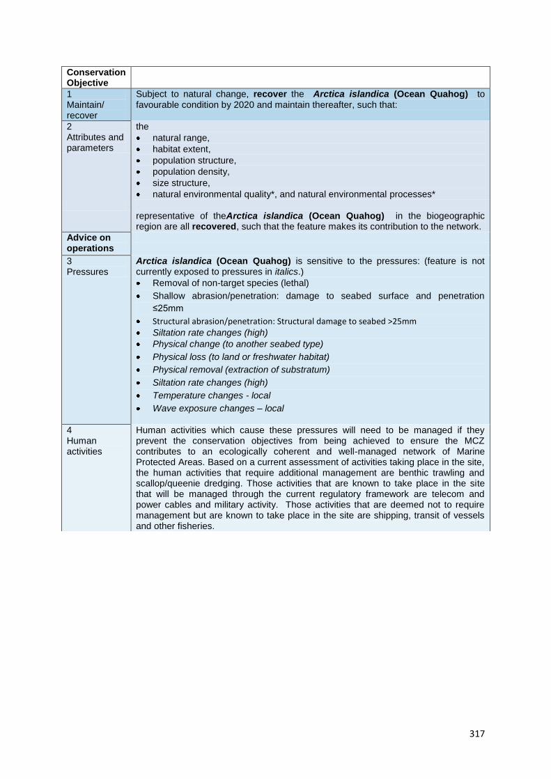
Conservation Objective
1 Maintain/ recover
Subject to natural change, recover the Arctica islandica (Ocean Quahog) to favourable condition by 2020 and maintain thereafter, such that:
2 Attributes and parameters
the
natural range,
habitat extent,
population structure,
population density,
size structure,
natural environmental quality*, and natural environmental processes*
representative of theArctica islandica (Ocean Quahog) in the biogeographic region are all recovered, such that the feature makes its contribution to the network.
Advice on operations
3 Pressures
Arctica islandica (Ocean Quahog) is sensitive to the pressures: (feature is not currently exposed to pressures in italics.)
Removal of non-target species (lethal)
Shallow abrasion/penetration: damage to seabed surface and penetration
≤25mm
Structural abrasion/penetration: Structural damage to seabed >25mm
Siltation rate changes (high)
Physical change (to another seabed type)
Physical loss (to land or freshwater habitat)
Physical removal (extraction of substratum)
Siltation rate changes (high)
Temperature changes - local
Wave exposure changes – local
4 Human activities
Human activities which cause these pressures will need to be managed if they prevent the conservation objectives from being achieved to ensure the MCZ contributes to an ecologically coherent and well-managed network of Marine Protected Areas. Based on a current assessment of activities taking place in the site, the human activities that require additional management are benthic trawling and scallop/queenie dredging. Those activities that are known to take place in the site that will be managed through the current regulatory framework are telecom and power cables and military activity. Those activities that are deemed not to require management but are known to take place in the site are shipping, transit of vessels and other fisheries.

12. Sites to which this site is related
rRA F is located within rMCZ6.
rMCZ 6 is approximately 26 km away from rMCZ 7 which is another site that has been recommended for
designation for the same EUNIS level 2 habitat types, sublittoral sediment and rock. There are a number of
existing protected areas with marine components which fall within the vicinity of rMCZ7. Within 50km on
the northern Ireland side of rMCZ6 are the conservation areas with marine feature designations: Murlough
(sea inlets), Strangford Lough (reefs and intertidal mud), Killough (SPA), Outer Ards (SPA, intertidal mud),
Copeland Islands (SPA). With 40 km of the Scottish side is the Mull of Galloway (SSSI including maritime
cliffs), Within 80 km of the site is Luce Bay and sands (a Scottish SAC with marine designations) and Loch
Ken.
13. Supporting documentation
Information Type of information Source
Location of subtidal sand Combined physical and
biological surveying with
habitat modelling
Robinson et al. 2007, Mellor et
al 2008
Location of subtidal mud Combined physical and
biological surveying with
habitat modelling
Robinson et al. 2007, Mellor et
al 2008
Location of sea-pen and
burrowing megafauna
communities
Video surveys and grab samples Robinson et al. 2007, Mellor et
al 2008
Location of ocean quahog
Arctica islandica
Butler 2009
Location of spawning and
nursery grounds
DEFRA/CEFAS:MB5301
References
BOLAM, S.G., BARRIO-FROJAN, C.R.S. & EGGLETON, J.D. 2010. Macrofaunal production along the UK
continental shelf. Journal of Sea Research 64: 166-179.
BUTLER, P. 2009 Establishing the Arctica islandica archive: Development of the definitive shell-based proxy for the North Atlantic shelf seas. PhD thesis, Bangor University.
ISCZ. 2011b. Meeting report from the 6th Irish Sea Conservation Zones Stakeholder Group meeting. RK
Partnership Ltd.
ISCZ. 2011c. Meeting report from the 7th Irish Sea Conservation Zones Stakeholder Group meeting. RK
Partnership Ltd.
ISCZ. 2011d. Meeting report from the 8th Irish Sea Conservation Zones Stakeholder Group meeting. RK
Partnership Ltd.

319
HORSBURGH, K.J., HILL, A.E., BROWN, J., FERNAND, L, GARVINE, R.W. ANGELICO, M.M.P. 2000. Seasonal
evolution of the cold pool gyre in the western Irish Sea. Progress in Oceanography 46: 1-58.
ROBINSON, K., RAMSAY, K., WILSON, J., MACKIE A., WHEELER, A., O’BEIRN F., LINDENBAUM, C., VAN
LANDEGHAM, K., MCBREEN, F., MITCHELL, N. 2007. HABMAP:Habitat Mapping for conservation and
management of the southern Irish Sea. Report to the Welsh European Funding Office. CCW Science Report
Number
810. Countryside Council for Wales, Bangor. 233 pp plus appendices.

320
MARINE CONSERVATION ZONE: SELECTION ASSESSMENT DOCUMENT
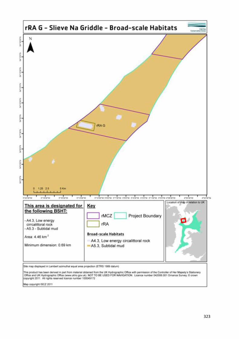
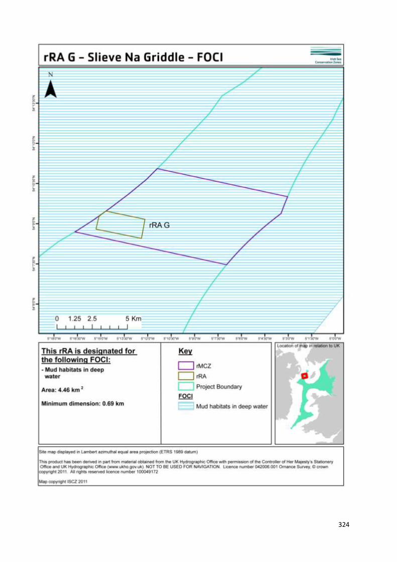
RRA G SLIEVE NA GRIDDLE
Version and issue date Amendments made
v1.0 August 2011
1. Site name
rRA G - Slieve Na Griddle
2. Site centre location
54° 9' 38.429" N, 5° 15' 12.681" W
54.160674 Lat, -5.253522Long. Lambert Azimuthal Equal Area projection, ETRS89 datum
3. Site surface area
4.46 Km2 (445.66 Ha)
4. Biogeographic region
JNCC regional sea: Irish Sea.
OSPAR region III: Celtic Seas.
5. Features proposed for designation within rRA G
Feature type Feature name Area covered within site (for broad
scale habitats and habitats of
conservation importance)
Broad scale habitat A4.3 Low energy
circalittoral rock
A5.3 Subtidal mud
2.04 Km2 (204.48 Ha)
2.41 Km2 (241.12 Ha)
Habitat of conservation
importance
Mud habitats in deep
water
4.46 Km2 (445.46 Ha)
Species of conservation
importance
n/a
Geological feature n/a
Other feature

321
6. Features within rRA: G not proposed for designation
Feature type Feature name Reason that feature has not been proposed
for designation
Broad scale
habitat
n/a
Habitat of
conservation
importance
n/a
Species of
conservation
importance
n/a

322
7. Map of site
323
324
325
8. Site summary
rRA G is located in rMCZ 7 in the western Irish Sea. This offshore site is sandwiched between the northern
Irish territorial waters to the west and the Isle of Man territorial waters to the east. Mud habitat and
bedrock makes up the seabed in the site and the depth ranges from100 to 200 m. The Pisces reef complex
is situated within the boundaries of rRA G. The Pisces reef qualifies as Annex 1 Reef habitat according to
the EU Habitats and Species Directive and has been formally recommended by Defra as a special area of
conservation (SAC) (JNCC 2011). The Pisces Reef is comprised of three bedrock pinnacles which rise 15-35
m up from the seafloor. The mud habitat present in rMCZ6 is part of the wider but geographically isolated
mud patch in the western Irish Sea. Low energy conditions that have been recorded in this area (Horsburgh
et al. 2000) provide a stable environment, characteristic of mud habitats in deep water. The mud habitat in
the wider region of rMCZ 7 supports a thriving and commercially important Neprhops norvegicus or Dublin
Bay Prawn fishery. Close to the reef, the soft sediment in which nephrops burrows are inaccessible to
traditional fishing methods, and as such the reef provides a natural refuge from fishing pressure. Placing a
RA in this region could provide an additional buffer of reduced fishing activity in the mud habitat. This
could have a potential positive impact for larval export outside of the site boundaries and also for the
potential recovery of seapen which have been recorded within the vicinity of the site.
9. Detailed site description
The boundary of rRA G encompasses areas of bedrock, which comprises part of the Pisces reef complex (a
proposed SAC) amidst deep water mud habitat.
The habitat data for this site stems from the MESH project (Mapping European Seabed Habitats) which
includes a JNCC commissioned survey, undertaken by the AFBI (Agri-Food and Biosciences), to ground truth
habitat maps with grab and towed video surveys to sample the biological community (JNCC 2007).
The area is a depositional environment for sediments with localised scouring around the bedrock and
boulders that make up the reef (Callaway et al. 2009). Geophysical, video and biological grab samples have
verified the presence of low energy circalittoral rock, or bedrock under a veneer of mud which was
classified as fine mud dominated by burrowing megafauna and scoured mud dominated by polychaetes
(Callaway et al. 2009). Callaway et al. (2009) noted that had video and acoustic data had been used alone,
the area would have been misclassified as a purely rocky reef area, without accounting for the soft mud
habitat covering the reef.
The Pisces reef qualifies as Annex 1 Reef habitat according to the EU Habitats and Species Directive and has
been formally recommended by Defra as a special area of conservation (SAC) (JNCC 2011). The Pisces reef
qualifies as Annex 1 Reef habitat according to the EU Habitats and Species Directive and has been formally
recommended by Defra as a special area of conservation (SAC) (JNCC 2011). The Pisces Reef is comprised of
three bedrock pinnacles which rise 15-35 m up from the seafloor. The reefs support a diverse animal
community, including hydroids (e.g Diphasia nugra), a range of sponges, including the cup sponge Axinella
infundibuliformi, echinoderms, for example the cushion star fish Porania pulvillus and various crustaceans,
for example the edible crab Cancer pagurus and squat lobster Munida rugosa. Additionally, the reef may
provide shelter for juvenile fish, including blue whiting, bib, red gurnard and wrasse (Judd 2004, cited in
JNCC 2011).
The mud habitat present in rMCZ6 is part of the wider but geographically isolated mud patch in the
western Irish Sea. The most well known burrowing marine invertebrate found in deep water mud is the

326
Dublin Bay prawn Nephrops norvegicus, for which there are valuable fishing grounds within this part of the
project area. The western Irish Sea nephrops population is larger than the eastern, which occurs on a
geographically distinct mud patch, and the two populations are not thought to be connected (Clements
2010). The nephrops fishery is particularly important since the collapse and decline of cod and whiting
fisheries in the region and, based on fishery independent video survey data (between 2003-2007), it
appears that nephrops burrows are decreasing in density (Clements 2010). There are, however, a whole
host of other animals which inhabit deep water mud including the brittlestar Amphiura chiajei and the
burrowing sea urchin Brissopsis lyrifera (Maddock 2010).
During submersible trials in the 1970s, scattered seapens were recorded in the soft sediments between
rocky outcrops of the Pisces reef, however they are no longer present in the same abundance (JNCC 2011).
More recently, incidental records of seapens have been noted during the ICES nephrops stock assessment
in an area close to the southern boundary of the site (Marine Institute / AFBI unpublished data). More
recent records to confirm the presence of seapens and burrowing megafauna are required for this habitat
feature to be designated in this MCZ, however it seems quite probable that given time and a decrease in
trawl activity, seapens may recover in this area.
10. Stakeholder and boundary considerations
In order to meet the ENG target, most stakeholders on the RSG accepted the inclusion of rRA G in the final
suite of Reference Areas. For a fuller context on the RSG discussions associated with the selection of
Reference Areas, readers of this report are encouraged to consult meeting reports from the ISCZ RSG
workshops held in May, June and July 2011 (ISCZ, 2011b,c,d).

327
11. Conservation objectives
Conservation Objective
1 Maintain/ recover
Subject to natural change, recover the Low Energy Circalittoral Rock to reference condition by 2020 and maintain thereafter, such that:
2
Attributes and parameters
the
extent,
diversity,
community structure,
natural environmental quality, and natural environmental processes
Representative of the Low Energy Circalittoral Rock in the biogeographic region are all recovered.
Advice on operations
3
Human activities
Reference areas should be managed to remove or prevent all extraction, deposition or potentially damaging activities.
Conservation Objective
1 Maintain/ recover
Subject to natural change, recover the Subtidal Mud to reference condition by 2020 and maintain thereafter, such that:
2
Attributes and parameters
the
extent,
diversity,
community structure,
natural environmental quality, and natural environmental processes
Representative of the Subtidal Mud in the biogeographic region are all recovered.
Advice on operations
3
Human activities
Reference areas should be managed to remove or prevent all extraction, deposition or potentially damaging activities.

328
Conservation Objective
1 Maintain/ recover
Subject to natural change, recover the Mud Habitats in Deep Water to reference condition by 2020 and maintain thereafter, such that:
2
Attributes and parameters
the
extent,
diversity,
community structure,
natural environmental quality, and natural environmental processes
Representative of the Mud Habitats in Deep Water in the biogeographic region are all recovered.
Advice on operations
3
Human activities
Reference areas should be managed to remove or prevent all extraction, deposition or potentially damaging activities.

12. Sites to which this site is related
rRA G lies within the south-western corner of rMCZ 7. rMCZ 7 is approximately 26 km away from rMCZ 6
which is another site that has been recommended for designation for the same EUNIS level 2 habitat types,
sublittoral sediment and rock. The site itself overlaps with the Pisces reef complex which has been
recommended to Defra as a special area of conservation (SAC). There are a number of existing protected
areas with marine components which fall within the vicinity of rMCZ7. Within 40km on the northern
Ireland side of rMCZ7are the conservation areas with marine feature designations: Murlough (sea inlets),
Strangford Lough (reefs and intertidal mud), Killough (SPA), Outer Ards (SPA, intertidal mud), Copeland
Islands (SPA). With 40 km of the Scottish side is the Mull of Galloway (SSSI including maritime cliffs), Within
80 km of the site is Luce Bay and sands (a Scottish SAC with marine designations) and Loch Ken.
13. Supporting documentation
This section should include the sources of the best available scientific and stakeholder information used to
identify sites and conservation objectives presented in a table format:
Information Type of information Source
Location of low energy
circalittoral rock
Surveys (seabed imagery,
acoustic, multibeam sonar,
grab samples, video surveys)
Judd 2007 and AFBI 2007,
referenced in JNCC 2011,
Callaway et al. 2009.
Location of subtidal mud Surveys (seabed imagery,
acoustic, multibeam sonar,
grab samples, video surveys)
Judd 2007 and AFBI 2007,
referenced in JNCC 2011,
Callaway et al. 2009.
Location of mud habitats in
deep water
Surveys (seabed imagery,
acoustic, multibeam sonar,
grab samples, video surveys)
Judd 2007 and AFBI 2007,
referenced in JNCC 2011,
Callaway et al. 2009.
References
CLEMENTS, A.J. 2010. Broad-scale ecological investigation of Nephrops norvegicus (L.) Burrow distribution
in the Western Irish Sea. Ph.D. Thesis, Queen's University Belfast.
ISCZ. 2011b. Meeting report from the 6th Irish Sea Conservation Zones Stakeholder Group meeting. RK
Partnership Ltd.
ISCZ. 2011c. Meeting report from the 7th Irish Sea Conservation Zones Stakeholder Group meeting. RK
Partnership Ltd.
ISCZ. 2011d. Meeting report from the 8th Irish Sea Conservation Zones Stakeholder Group meeting. RK
Partnership Ltd.
JNCC. 2007. North West Irish Sea mounds: hard and soft substrate habitats. JNCC Contract Reference No:
F90-01-942(8).

330
JNCC. 2011. Offshore Special Area of Conservation: Pisces Reef Complex. SAC Selection Assessment. Version
3.0 (17th January 2011).
CALLAWAY, A., SMYTH, J., BROWN, C.J., QUINN, R., SERVICE, M. & LONG, D.2009. The impact of scour
processes on a smothered reef system in the Irish Sea. Estuarine, Coastal and Shelf Science. 84: 409-418.
MADDOCK, A. 2010. UK Biodiversity Action Plan; Priority Habitat Descriptions. BRIG (ed. Ant [Accessed 6
April 2011]
http://www.ukbap.org.uk/library/UKBAPPriorityHabitatDescriptionsRevised20100730.pdf

331
MARINE CONSERVATION ZONE: SELECTION ASSESSMENT DOCUMENT
RRA H ALLONBY BAY
Version and issue date Amendments made
v1.0 August 2011
1. Site name
rRA H - Allonby Bay
2. Site centre location
54° 47' 22.760" N, 3° 28' 39.575" W
54.789655 Lat, -3.477659Long. Lambert Azimuthal Equal Area projection, ETRS89 datum
3. Site surface area
4.91 Km2 (490.69 Ha)
4. Biogeographic region
JNCC regional sea: Irish Sea.
OSPAR region III: Celtic Seas.
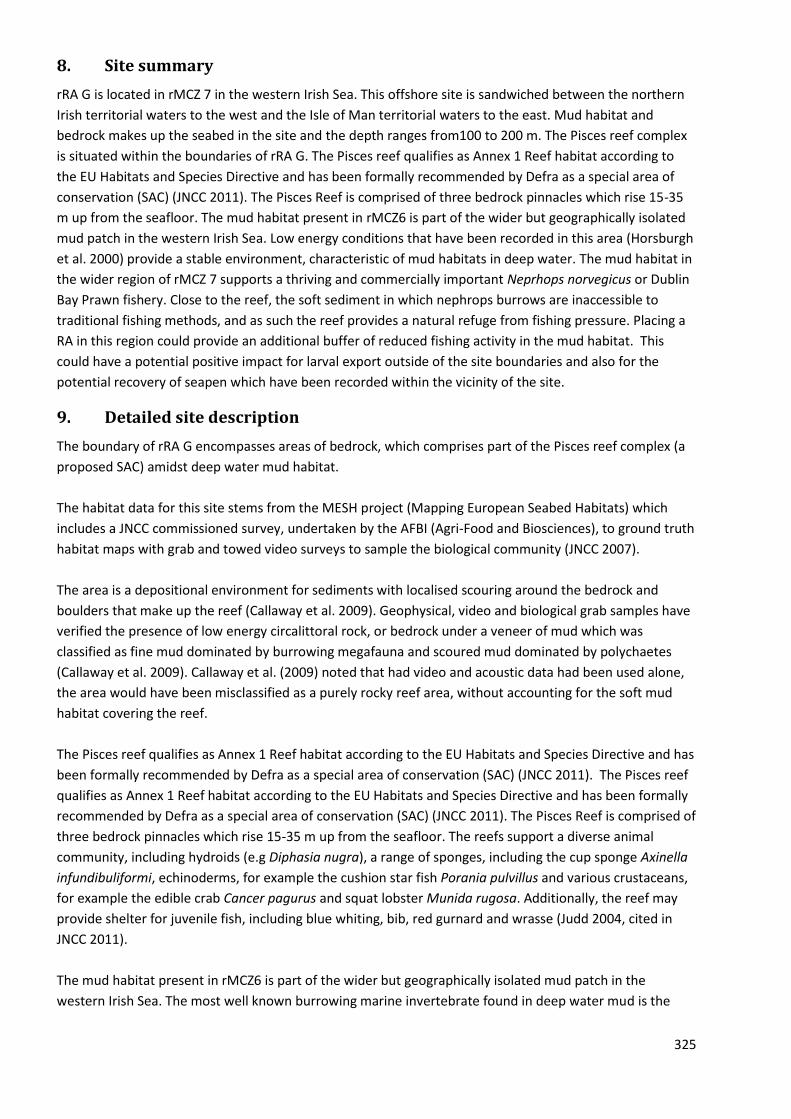
5. Features proposed for designation within rRA H
Feature type Feature name Area covered within site (for broad
scale habitats and habitats of
conservation importance)
Broad scale habitat A3.2 Moderate energy
infralittoral rock
A5.1 Subtidal coarse
sediment
A5.2 Subtidal sand
0.04 Km2 (3.69 Ha)
4.81 Km2 (480.85 Ha)
0.06Km2 (6.17 Ha)
Habitat of conservation
importance
Subtidal sands and gravels 4.91 Km2 (490.69 Ha)
Species of conservation
importance
n/a
Geological feature n/a
Other feature n/a

332
6. Features within rRA H not proposed for designation
Feature type Feature name Reason that feature has not been proposed
for designation
Broad scale
habitat
n/a
Habitat of
conservation
importance
n/a
Species of
conservation
importance
n/a

333
7. Map of site

334
335

336

337
8. Site summary
rRA H is situated in north western corner of rMCZ 10 in Allonby Bay on the north Cumbrian coast. It is the
most northern reference area in the ISCZ project area. This offshore site is known locally as Maryport
Roads and is known to be extremely biologically diverse (Perkins, 1973). Maryport Roads, an area of
subtidal coarse sediment and cobbles originally identified by Perkins and was surveyed extensively
between the late 1960s and 1980s. The site lies 0.9km offshore and has a depth range of < 10 m. The
location of rRA H helps to link inshore and offshore sand and coarse sediment habitats.
9. Detailed site description
Maryport Roads was initially identified by Perkins (1973) as an extremely diverse, shallow and cobbley area
with associated subtidal mixed sediments. It was thought by the RSG that this area would benefit from
MCZ protection. Within this area the substrate is generally thought to be incompatible with benthic fishing
and was, therefore, deemed an excellent site for a reference area as it would have relatively little socio-
economic impact. Maryport Roads is an important offshore boulder and cobble scar ground. The
environment is extremely productive and diverse with sponges, soft corals such as dead man’s fingers
Alyconium digitatum, bryozoans including hornwrack Flustra folacea, the red sea squirt Dendrodoa
grossularia, anemones, hydroids and the reef building honeycomb worm Sabellaria alveolata (EN 1997).
Subtidal sand sediments at Maryport Roads are characterised by the bivalves Mactra stultorum and banded
wedge shell Donax vittatus, medium sands by the bivalve surf clam Spisula solida, and muddy sands by the
polychaete Nephtys spp. and the bivalves Nucula sulcata, Abra albida and Angulus tenuis (Perkins 1973,
cited in Mills 1998).
The communities recorded from sublittoral scar grounds exhibit rich and well developed epifaunal
communities (living on the benthic substrate) similar to rocky underboulder communities characterised by
the sponge breadcrumb sponge Halichondria panicea, the hydroid Abietinaria abietina, the polychaete ross
worm Sabellaria alveolata, the common whelk Buccinum undatum, the horse mussel Modiolus modiolus,
the bryozoan hornwrack Flustra foliacea and the sea squirt Dendrodoa grossularia. Sublittoral scar grounds
were also considered to be important for the presence of commercially important species such as the
edible crab Cancer pagurus and lobster Homarus gammarus, and for the fish that use them as feeding
grounds (Mills 1998).
rRA H has also been identified by the RSG as an important spawning ground for commercial species
including skate - thornback ray Raja clavata and bass. The shallow waters and rugosity (complexity of the
habitat) provide a natural refuge area from predators. It is also thought to be an important pupping ground
for harbour porpoise Phocoena phocoena.
There is much anecdotal evidence (local ecological knowledge) to inform and support the high biodiversity
of this area, but there is a distinct paucity of recent, scientific peer reviewed literature. Designating rRA H
as a reference area helps to link inshore and offshore sand and coarse sediment habitats. It also has the
potential to inform, if closely monitored, local fisheries science in terms of a greater understanding of
spawning and nursery grounds of commercially important species, as well as having wider research
potential.

338
10. Stakeholder and boundary considerations
In order to meet the ENG target, most stakeholders on the RSG accepted the inclusion of rRA H in the final
suite of Reference Areas. For a fuller context on the RSG discussions associated with the selection of
Reference Areas, readers of this report are encouraged to consult meeting reports from the ISCZ RSG
workshops held in May, June and July 2011 (ISCZ, 2011b,c,d).
339
11. Conservation Objectives
Conservation Objective
1 Maintain/ recover
Subject to natural change, recover the Subtidal Coarse Sediment to reference condition by 2020 and maintain thereafter, such that:
2
Attributes and parameters
the
extent,
diversity,
community structure,
natural environmental quality*, and natural environmental processes*
Representative of the Subtidal Coarse Sediment in the biogeographic region are all recovered.
Advice on operations
3
Human activities
Reference areas should be managed to remove or prevent all extraction, deposition or potentially damaging activities.
Conservation Objective
1 Maintain/ recover
Subject to natural change, recover the Subtidal Sand to reference condition by 2020 and maintain thereafter, such that:
2
Attributes and parameters
the
extent,
diversity,
community structure,
natural environmental quality*, and natural environmental processes*
Representative of the Subtidal Sand in the biogeographic region are all recovered.
Advice on operations
3
Human activities
Reference areas should be managed to remove or prevent all extraction, deposition or potentially damaging activities.

340
Conservation Objective
1 Maintain/ recover
Subject to natural change, recover the Moderate Energy Infralittoral Rock to reference condition by 2020 and maintain thereafter, such that:
2
Attributes and parameters
the
extent,
diversity,
community structure,
natural environmental quality*, and natural environmental processes*
Representative of the Moderate Energy Infralittoral Rock in the biogeographic region are all recovered.
Advice on operations
3
Human activities
Reference areas should be managed to remove or prevent all extraction, deposition or potentially damaging activities.
Conservation Objective
1 Maintain/ recover
Subject to natural change, recover the Subtidal Sands and Gravels to reference condition by 2020 and maintain thereafter, such that:
2
Attributes and parameters
the
extent,
diversity,
community structure,
natural environmental quality*, and natural environmental processes*
Representative of the Subtidal Sands and Gravels in the biogeographic region are all recovered.
Advice on operations
3
Human activities
Reference areas should be managed to remove or prevent all extraction, deposition or potentially damaging activities.

341
12. Sites to which this site is related
rRA H lies within the northwest corner of rMCZ10. rMCZ 10 is located in between two recommended MCZs.
The Solway is 23 km (12 nm) to the north, a site that is being recommended for designation for two highly
mobile species, smelt Osmerus eperlanus and eel Anguilla Anguilla. The Solway MCZ also contains the same
EUNIS level 2 habitat types, sublittoral sediment, littoral rock and littoral sediment. Located 38 km (20 nm)
to the south of rMCZ 10 is rMCZ 11, which shares the same EUNIS level 2 habitats, sublittoral sediment,
littoral rock, littoral sediment and infra-littoral rock.
rMCZ 10 is in the vicinity (defined here as within 80 km (43 nm) of the following existing or proposed sites
that have marine features designated for protection: Morecambe Bay (SPA, SSSI) and Duddon estuary (SPA
/ SSSI). A further three sites are within 40 km of the rMCZ10, Solway Firth (SAC), Drigg coast (SAC), Upper
Solway flats and marshes (SPA).
13. Supporting documentation
Information Type of information Source
Ecological Diversity Local stakeholder knowledge RSG
Intertidal surveys Ecological surveys JNCC MNCR
References
ENGLISH NATURE. 1997. Cumbrian Coast Natural Area Profile. Available from:
http://www.sssi.naturalengland.org.uk/science/natural/profiles%5CnaProfile119.pdf. Last accessed 25th
August 2011.
ISCZ. 2011b. Meeting report from the 6th Irish Sea Conservation Zones Stakeholder Group meeting. RK
Partnership Ltd.
ISCZ. 2011c. Meeting report from the 7th Irish Sea Conservation Zones Stakeholder Group meeting. RK
Partnership Ltd.
ISCZ. 2011d. Meeting report from the 8th Irish Sea Conservation Zones Stakeholder Group meeting. RK
Partnership Ltd.
Lancaster, J. 2010. Cumbrian Sea Fisheries Committee shore survey. Solveno Marine Environmental
Consultants.
MILLS, D.J.L. 1998. Liverpool Bay to the Solway (Rhos-on-Sea to the Mull of Galloway) (MNCR Sector 11). In:
Marine Nature Conservation Review. Benthic marine ecosystems of Great Britain and the north-east
Atlantic ed. p. 315–338. Peterborough, Joint Nature Conservation Committee. (Coasts and seas of the
United Kingdom. MNCR series).
PERKINS, E.J. 1973. The Marine Fauna and Flora of the Solway Firth. The Dumfriesshire and Galloway
Antiquarian Society; First edition

342
Perkins, E.J. 1988. Fourteenth report to the Cumbria Sea-Fisheries Committee. Solway Firth survey - 1st July 1987 to 30th June 1988. Solway Marine Investigations, Maryport, Cumbria.

343
MARINE CONSERVATION ZONE: SELECTION ASSESSMENT DOCUMENT
RRA I CUMBRIAN COAST (1)
Version and issue date Amendments made
v1.0 August 2011
1. Site name
rRA I - Cumbrian Coast (1)
2. Site centre location
54° 29' 37.440" N, 3° 37' 18.975" W
54.493733 Lat, -3.621937 Long. Lambert Azimuthal Equal Area projection, ETRS89 datum
3. Site surface area
0.12 Km2 (11.86 Ha)
4. Biogeographic region
JNCC regional sea: Irish Sea.
OSPAR region III: Celtic Seas.
5. Features proposed for designation within rRA I
Feature type Feature name Area covered within site (for broad
scale habitats and habitats of
conservation importance)
Broad scale habitat A1.1 High energy
infralittoral rock
A5.2 Subtidal sand
A5.3 Subtidal mud
0.02 Km2 (1.98 Ha)
0.05 Km2 (5.33 Ha)
0.05 Km2 (4.53 Ha)
Habitat of conservation
importance
Subtidal sands and gravels
Intertidal underbouler
communities
0.03 Km2 (3.08 Ha)
NA
Species of conservation
importance
Geological feature
Other feature

344
6. Features within rRA I not proposed for designation
Feature type Feature name Reason that feature has not been proposed
for designation
Broad scale
habitat
Habitat of
conservation
importance
Species of
conservation
importance

345
7. Map of site

346

347

348

349
8. Site summary rRA I
rRA I is recommended for designation for high energy infralittoral rock, and is one of the only examples of
such a habitat within the ISCZ project area. It is comprised of typically diverse intertidal boulder
communities with a distinct zoning pattern of species common to rocky shores.
9. Detailed site description
rRA I lies within the multipart rMCZ 11 (Cumbria coast) from Fleswick Bay to South Head, St. Bees Head.
The recommended site contains some of the best and only examples of high energy infralittoral and
shallow infralittoral rock habitats within the ISCZ project area.
Vertical sandstone cliffs back the shore within the site. To the north of the site the foreshore consists of
extensive fine shingle and pebbles, above heavily abraded and wave cut sculptured rock platforms, giving
way to boulders on the lower shore. At the northern boundary of the site, the shore narrows into a more
steeply sloping shore comprised of large boulders (Lumb pers. comm. 2011).
The upper surface of the large boulders and bedrock, in the splash zone of the littoral fringe at the base of
the cliffs, are dominated by lichen species such as Xanatharia spp. and Caloplaca spp. Fresh water runoff
influences the presence of large quantities of green algae Enteromorpha. Rough periwinkles Littorina
saxatilis are also present along with sparse brown algae (JNCC Marine recorder data, 2011).
The upper shore has a community of spiral wrack Fucus spiralis, knotted wrack Ascophyllum nodosum,
common barnacles Chthamalus spp., common limpet Patella vulgata, and rough periwinkles Littorina
saxatilis (JNCC Marine recorder data, 2011).
The mid shore is dominated by barnacles Chthamalus spp. at the upper limit of the zone then exclusively
Balanus balanoides. Common limpets Patella vulgata and dog whelks Nucella lapillus are common.
Seaweeds, bladder wrack Fucus vesiculosus and red seaweed Corallina officinalis are abundant in rock
pools. Tops of boulders exhibit dense aggregations of common mussel Mytilus edulis (JNCC Marine
recorder data, 2011).
The lower shore presents a mixture of boulders, cobbles and pebbles. Underboulder fauna are noted and
small oarweed Laminaria digitata, coralline and red crusting algae are also noted. Sand scoured boulders
are seen with barnacles Balanus crenatus and crustose communites. Common starfish Asterias rubens and
hermit crab (Pagarus bernhardus) are present on the sand bed (JNCC Marine recorder data, 2011).
10. Stakeholder and boundary considerations
In order to meet the ENG target, most stakeholders on the RSG accepted the inclusion of rRA I in the final
suite of Reference Areas. For a fuller context on the RSG discussions associated with the selection of
Reference Areas, readers of this report are encouraged to consult meeting reports from the ISCZ RSG
workshops held in May, June and July 2011 (ISCZ, 2011b,c,d).
350
11. Conservation objectives
Conservation Objective
1 Maintain/ recover
Subject to natural change, recover the Subtidal Mud to reference condition by 2020 and maintain thereafter, such that:
2
Attributes and parameters
the
extent,
diversity,
community structure,
natural environmental quality, and natural environmental processes
Representative of the Subtidal Mud in the biogeographic region are all recovered.
Advice on operations
3
Human activities
Reference areas should be managed to remove or prevent all extraction, deposition or potentially damaging activities.
Conservation Objective
1 Maintain/ recover
Subject to natural change, recover the Subtidal Sand to reference condition by 2020 and maintain thereafter, such that:
2
Attributes and parameters
the
extent,
diversity,
community structure,
natural environmental quality, and natural environmental processes
Representative of the Subtidal Sand in the biogeographic region are all recovered.
Advice on operations
3
Human activities
Reference areas should be managed to remove or prevent all extraction, deposition or potentially damaging activities.

351
Conservation Objective
1 Maintain/ recover
Subject to natural change, recover the Intertidal Under Boulder Communities to reference condition by 2020 and maintain thereafter, such that:
2
Attributes and parameters
the
extent,
diversity,
community structure,
natural environmental quality, and natural environmental processes
Representative of the Intertidal Under Boulder Communities in the biogeographic region are all recovered.
Advice on operations
3
Human activities
Reference areas should be managed to remove or prevent all extraction, deposition or potentially damaging activities.
Conservation Objective
1 Maintain/ recover
Subject to natural change, recover the Subtidal Sands and Gravels to reference condition by 2020 and maintain thereafter, such that:
2
Attributes and parameters
the
extent,
diversity,
community structure,
natural environmental quality, and natural environmental processes
Representative of the Subtidal Sands and Gravels in the biogeographic region are all recovered.
Advice on operations
3
Human activities
Reference areas should be managed to remove or prevent all extraction, deposition or potentially damaging activities.
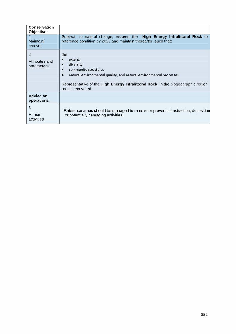
352
Conservation Objective
1 Maintain/ recover
Subject to natural change, recover the High Energy Infralittoral Rock to reference condition by 2020 and maintain thereafter, such that:
2
Attributes and parameters
the
extent,
diversity,
community structure,
natural environmental quality, and natural environmental processes
Representative of the High Energy Infralittoral Rock in the biogeographic region are all recovered.
Advice on operations
3
Human activities
Reference areas should be managed to remove or prevent all extraction, deposition or potentially damaging activities.

12. Sites to which this site is related
rRA I lies within rMCZ 11. rMCZ 11 lies approximately 24 km to the east of rMCZ 1. Within zone 11 lies the
already designated St. Bee’s Head Natura site. The boundaries of rMCZ11 also overlap with another
designated Natura site in Drigg coast. RMCZ 2 lies 40km to the south and encompasses the Duddon estuary
Natura site.
13. Supporting documentation
Information Type of information Source
Location of high energy
intertidal rock / intertidal
underboulder communities
Shore transect surveys MESH
Intertidal sand and muddy sand
Shore transect surveys MESH
High energy infralittoral rock Shore transect surveys MESH
Intertidal zone
Shore transect surveys JNCC marine recorder data,
2011
References
ISCZ. 2011b. Meeting report from the 6th Irish Sea Conservation Zones Stakeholder Group meeting. RK
Partnership Ltd.
ISCZ. 2011c. Meeting report from the 7th Irish Sea Conservation Zones Stakeholder Group meeting. RK
Partnership Ltd.
ISCZ. 2011d. Meeting report from the 8th Irish Sea Conservation Zones Stakeholder Group meeting. RK
Partnership Ltd.
JNCC Marine recorder data 2011

354
MARINE CONSERVATION ZONE: SELECTION ASSESSMENT DOCUMENT
RRA J CUMBRIAN COAST (2)
Version and issue date Amendments made
v1.0 August 2011
1. Site name
rRA J - Cumbrian Coast (2)
2. Site centre location
54° 31' 35.541" N, 3° 37' 12.005" W
54.526539 Lat, -3.620001 Long. Lambert Azimuthal Equal Area projection, ETRS89 datum
3. Site surface area
1.06 Km2 (105.52 Ha)
4. Biogeographic region
JNCC regional sea: Irish Sea.
OSPAR region III: Celtic Seas.
5. Features proposed for designation within rRA J
Feature type Feature name Area covered within site (for broad
scale habitats and habitats of
conservation importance)
Broad scale habitat A1.1 High energy intertidal
rock
A2.4 Intertidal mixed
sediments
A5.2 Subtidal sand
0.03 Km2 (2.89 Ha)
0.03 Km2 (3.35 Ha)
0.94 Km2 (94.15 Ha)
Habitat of conservation
importance
Intertidal underbouler
communities
Subtidal sands and gravels
0.17 Km2 (17.42 Ha)
N/A
Species of conservation
importance
Geological feature
Other feature

355
6. Features within rRA J not proposed for designation
Feature type Feature name Reason that feature has not been proposed
for designation
Broad scale
habitat
Habitat of
conservation
importance
Species of
conservation
importance

356
7. Map of site

357

358

359
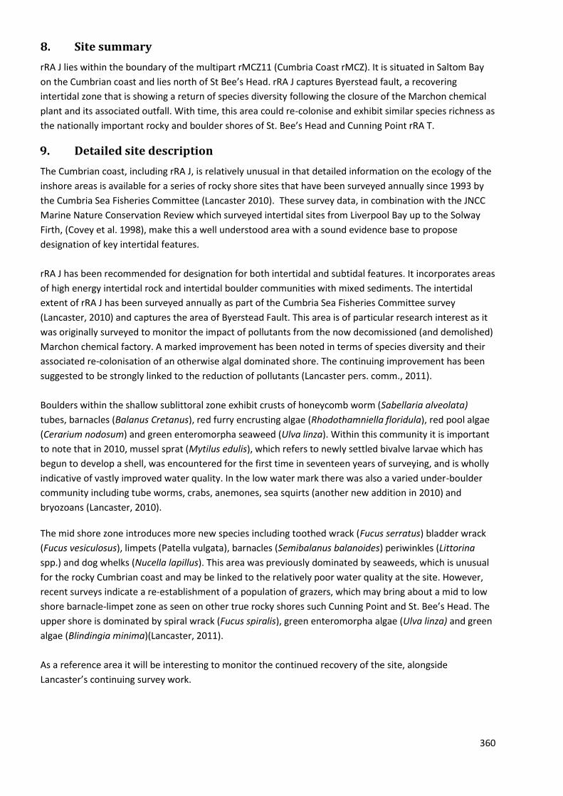
360
8. Site summary
rRA J lies within the boundary of the multipart rMCZ11 (Cumbria Coast rMCZ). It is situated in Saltom Bay
on the Cumbrian coast and lies north of St Bee’s Head. rRA J captures Byerstead fault, a recovering
intertidal zone that is showing a return of species diversity following the closure of the Marchon chemical
plant and its associated outfall. With time, this area could re-colonise and exhibit similar species richness as
the nationally important rocky and boulder shores of St. Bee’s Head and Cunning Point rRA T.
9. Detailed site description
The Cumbrian coast, including rRA J, is relatively unusual in that detailed information on the ecology of the
inshore areas is available for a series of rocky shore sites that have been surveyed annually since 1993 by
the Cumbria Sea Fisheries Committee (Lancaster 2010). These survey data, in combination with the JNCC
Marine Nature Conservation Review which surveyed intertidal sites from Liverpool Bay up to the Solway
Firth, (Covey et al. 1998), make this a well understood area with a sound evidence base to propose
designation of key intertidal features.
rRA J has been recommended for designation for both intertidal and subtidal features. It incorporates areas
of high energy intertidal rock and intertidal boulder communities with mixed sediments. The intertidal
extent of rRA J has been surveyed annually as part of the Cumbria Sea Fisheries Committee survey
(Lancaster, 2010) and captures the area of Byerstead Fault. This area is of particular research interest as it
was originally surveyed to monitor the impact of pollutants from the now decomissioned (and demolished)
Marchon chemical factory. A marked improvement has been noted in terms of species diversity and their
associated re-colonisation of an otherwise algal dominated shore. The continuing improvement has been
suggested to be strongly linked to the reduction of pollutants (Lancaster pers. comm., 2011).
Boulders within the shallow sublittoral zone exhibit crusts of honeycomb worm (Sabellaria alveolata)
tubes, barnacles (Balanus Cretanus), red furry encrusting algae (Rhodothamniella floridula), red pool algae
(Cerarium nodosum) and green enteromorpha seaweed (Ulva linza). Within this community it is important
to note that in 2010, mussel sprat (Mytilus edulis), which refers to newly settled bivalve larvae which has
begun to develop a shell, was encountered for the first time in seventeen years of surveying, and is wholly
indicative of vastly improved water quality. In the low water mark there was also a varied under-boulder
community including tube worms, crabs, anemones, sea squirts (another new addition in 2010) and
bryozoans (Lancaster, 2010).
The mid shore zone introduces more new species including toothed wrack (Fucus serratus) bladder wrack
(Fucus vesiculosus), limpets (Patella vulgata), barnacles (Semibalanus balanoides) periwinkles (Littorina
spp.) and dog whelks (Nucella lapillus). This area was previously dominated by seaweeds, which is unusual
for the rocky Cumbrian coast and may be linked to the relatively poor water quality at the site. However,
recent surveys indicate a re-establishment of a population of grazers, which may bring about a mid to low
shore barnacle-limpet zone as seen on other true rocky shores such Cunning Point and St. Bee’s Head. The
upper shore is dominated by spiral wrack (Fucus spiralis), green enteromorpha algae (Ulva linza) and green
algae (Blindingia minima)(Lancaster, 2011).
As a reference area it will be interesting to monitor the continued recovery of the site, alongside
Lancaster’s continuing survey work.

361
10. Stakeholder and boundary considerations
In order to meet the ENG target, most stakeholders on the RSG accepted the inclusion of rRA J in the final
suite of Reference Areas. For a fuller context on the RSG discussions associated with the selection of
Reference Areas, readers of this report are encouraged to consult meeting reports from the ISCZ RSG
workshops held in May, June and July 2011 (ISCZ, 2011b,c,d).

362
11. Conservation objectives
Conservation Objective
1 Maintain/ recover
Subject to natural change, recover the Intertidal Mixed Sediments to reference condition by 2020 and maintain thereafter, such that:
2
Attributes and parameters
the
extent,
diversity,
community structure,
natural environmental quality, and natural environmental processes
Representative of the Intertidal Mixed Sediments in the biogeographic region are all recovered.
Advice on operations
3
Human activities
Reference areas should be managed to remove or prevent all extraction, deposition or potentially damaging activities.
Conservation Objective
1 Maintain/ recover
Subject to natural change, recover the Subtidal Sand to reference condition by 2020 and maintain thereafter, such that:
2
Attributes and parameters
the
extent,
diversity,
community structure,
natural environmental quality, and natural environmental processes
Representative of the Subtidal Sand in the biogeographic region are all recovered.
Advice on operations
3
Human activities
Reference areas should be managed to remove or prevent all extraction, deposition or potentially damaging activities.

363
Conservation Objective
1 Maintain/ recover
Subject to natural change, recover the Intertidal Under Boulder Communities to reference condition by 2020 and maintain thereafter, such that:
2
Attributes and parameters
the
extent,
diversity,
community structure,
natural environmental quality, and natural environmental processes
Representative of the Intertidal Under Boulder Communities in the biogeographic region are all recovered.
Advice on operations
3
Human activities
Reference areas should be managed to remove or prevent all extraction, deposition or potentially damaging activities.
Conservation Objective
1 Maintain/ recover
Subject to natural change, recover the Subtidal Sands and Gravels to reference condition by 2020 and maintain thereafter, such that:
2
Attributes and parameters
the
extent,
diversity,
community structure,
natural environmental quality, and natural environmental processes
Representative of the Subtidal Sands and Gravels in the biogeographic region are all recovered.
Advice on operations
3
Human activities
Reference areas should be managed to remove or prevent all extraction, deposition or potentially damaging activities.
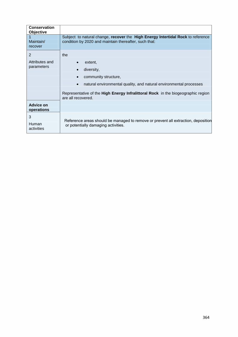
364
Conservation Objective
1 Maintain/ recover
Subject to natural change, recover the High Energy Intertidal Rock to reference condition by 2020 and maintain thereafter, such that:
2
Attributes and parameters
the
extent,
diversity,
community structure,
natural environmental quality, and natural environmental processes
Representative of the High Energy Infralittoral Rock in the biogeographic region are all recovered.
Advice on operations
3
Human activities
Reference areas should be managed to remove or prevent all extraction, deposition or potentially damaging activities.

12. Sites to which this site is related
rRA J lies within rMCZ 11. rMCZ 11 lies approximately 24 km to the east of rMCZ 1. Within zone 11 lies the
already designated St. Bee’s Head Natura site. The boundaries of rMCZ11 also overlap with another
designated Natura site in Drigg coast. RMCZ 2 lies 40km to the south and encompasses the Duddon estuary
Natura site.
13. Supporting documentation
Information Type of information Source
Location of high energy
intertidal rock / intertidal
underboulder communities
Shore transect surveys MESH, Covey et al. 1998,
Lancaster 2010
Intertidal sand and muddy sand
Shore transect surveys MESH, Covey et al. 1998,
Lancaster 2010
Intertidal biogenic reefs (blue
mussel beds and honeycomb
worm Sabellaria alveolata
reefs)
Shore transect surveys MESH, Covey et al. 1998,
Lancaster 2010
High energy infralittoral rock Shore transect surveys MESH, Covey et al. 1998,
Lancaster 2010
References
COVEY, R., FORTUNE, F., NICHOLS, D.M. & THORPE, K.1998. Marine Nature Conservation Review. Sector 11.
Liverpool Bay and the Solway Firth: area summaries. Peterborough, Joint Nature Conservation Committee.
(Coasts and seas of the United Kingdom. MNCR series
ISCZ. 2011b. Meeting report from the 6th Irish Sea Conservation Zones Stakeholder Group meeting. RK
Partnership Ltd.
ISCZ. 2011c. Meeting report from the 7th Irish Sea Conservation Zones Stakeholder Group meeting. RK
Partnership Ltd.
ISCZ. 2011d. Meeting report from the 8th Irish Sea Conservation Zones Stakeholder Group meeting. RK
Partnership Ltd.
LANCASTER, J. 2010. Cumbrian Sea Fisheries Committee shore survey. Solenvo Marine Environmental
Consultants.

366
MARINE CONSERVATION ZONE: SELECTION ASSESSMENT DOCUMENT
RRA K TARN POINT
Version and issue date Amendments made
v1.0 August 2011
1. Site name
rRA K - Tarn Point
2. Site centre location
54° 17' 35.313" N , 3° 25' 27.348" W
54.293143 Lat, -3.424263 Long. Lambert Azimuthal Equal Area projection, ETRS89 datum
3. Site surface area
1.07 Km2 (107.34 Ha)
4. Biogeographic region
JNCC regional sea: Irish Sea.
OSPAR region III: Celtic Seas.
5. Features proposed for designation within rRA K
Feature type Feature name Area covered within site (for broad
scale habitats and habitats of
conservation importance)
Broad scale habitat A2.7 Intertidal biogenic
reefs
A3.1 High energy
infralittoral rocks
0.23 Km2 (23.35 Ha)
0.002 Km2 (0.21 Ha)
Habitat of conservation
importance
Blue mussel (Mytilus
edulis) beds
Honeycomb worm
(Sabellaria alveolata) reefs
-
0.34 Km2 (33.77 Ha)
Species of conservation
importance
Geological feature
Other feature

367
6. Features within rRA K not proposed for designation
Feature type Feature name Reason that feature has not been proposed
for designation
Broad scale
habitat
Intertidal sand and
Muddy sand
Subtidal sand
Covered by gap analysis
Habitat of
conservation
importance
Subtidal sands and
gravels
Based on the project team’s rule of thumb
for designating features
Species of
conservation
importance

368
7. Map of site
369

370

371

372
8. Site summary
RA K is a small intertidal site situated in Tarn Point on the Cumbrian coast. Tarn Point has been subject to
annual ecological surveys by the Cumbrian Sea Fisheries Committee since 1993. The benthic habitat is
composed of two broadscale habitat feature types (BSHT), intertidal biogenic reefs and high energy
infralittoral rocks. The biogenic reefs feature two distinct habitats of conservation importance (FOCI): Blue
Mussel beds (Mytilus edulis) and Honeycomb worm reefs (Sabellaria alveolata). A third FOCI is also present
within the boundaries of RA: K: subtidal sands and gravels however this habitat has not been designated
based on the projects rule of thumb.
9. Detailed site description
It is important to distinguish between blue mussels commonly found around all UK coasts and blue mussel (Mytilus edulis) beds. As a habitat FOCI, blue mussel beds only refers to natural beds found over a variety of sediments, this excludes artificially created mussel beds and mussel beds that occur over rocks and boulders (Ecological Network Guidance, 2010). Beds of blue mussels are found on the mid to lower shore on a mixture of substrates, but primarily cobbles and pebbles on muddy sediments, sand and mud. At high densities (over 30%) mussels bind to the soft substrate providing a natural habitat for other flora and fauna (OSPAR Commission 2008). In RA: K it is important to note that the ephemeral blue mussel beds have been designated as a habitat FOCI based on historical ecological survey data of Tarn Point carried out by the Cumbrian Sea Fisheries Committee where they are shown to be abundant. The second habitat FOCI, honeycomb worm (Sabellaria alveolata) reefs are formed from dense aggregations of individual honeycomb worms. These reefs typically form over mixed substrates (e.g. sand, gravel, pebble and cobble) and rocky habitats. The honeycomb worm reefs of Tarn point, as identified by Lancaster 2010, have been found to reach up to 60 cm in height.
Figure 1: Sabillaria alveolata, individual tubes. Figure 2: Sabillaria alveolata mound -covered in green algae
(Photo courtesy of Lancaster) (Photo courtesy of Lancaster)
Both blue mussel beds and honeycomb worm reefs constitute biogenic reefs which are defined as being ‘solid massive structures which are created by accumulations of organisms, usually arising from the seabed clearly forming a substantial, discrete community or habitat which is very different from the surrounding seabed’ (Holt et al. 1998). Blue mussel beds and honeycomb worms provide a stable, hard substrate in areas of otherwise soft sediments or unstable rocky ground and this underlies their ecological importance; they stabilize the sediment forming hard structures to which other sessile (or immobile) organisms can attach; provide a heterogenous or varied surface structure, for example, crevices which give shelter to other animals; and the accumulated faeces and associated sediments is an important food source for other species (Holt et al. 1998). As a result, both blue mussel beds and honeycomb worm reefs support a varied biological community.
373
The Cumbrian coast is relatively unusual compared to the rest of Irish Sea Conservation Zone project area, as detailed information on the ecology of the inshore areas is available for a series of rocky shore sites that have been surveyed annually since 1993 by the Cumbria Sea Fisheries Committee (Lancaster 2010). The Solway Firth represents the northerly limit of honeycomb worm reefs, and the Cumbrian coast is noted for having the UKs most extensive and best representative examples of this habitat type (Lancaster J. pers. comm. 2010). The presence of the BSHT of high energy infralittoral rock, as identified in the MESH survey, despite being a subtidal habitat is being designated but acknowledged as a small area due to the size of the feature and is not well represented across the MCZ’s. Subtidal sands and gravels are also present within the boundaries of rRA: K. However, due to the sites size and intertidal designation status, purely subtidal features are not being included. But it is worthy to note that this habitat type is host to a range of marine invertebrates, including anemones, polychaete worms, bivalves, amphipods (Maddock 2010).
10. Stakeholder and boundary considerations
In order to meet the ENG target, most stakeholders on the RSG accepted the inclusion of rRA K in the final
suite of Reference Areas. For a fuller context on the RSG discussions associated with the selection of
Reference Areas, readers of this report are encouraged to consult meeting reports from the ISCZ RSG
workshops held in May, June and July 2011 (ISCZ, 2011b,c,d).

374
11. Conservation objectives
Conservation Objective
1 Maintain/ recover
Subject to natural change, recover the High Energy Infralittoral Rock to reference condition by 2020 and maintain thereafter, such that:
2
Attributes and parameters
the
extent,
diversity,
community structure,
natural environmental quality, and natural environmental processes
Representative of the High Energy Infralittoral Rock in the biogeographic region are all recovered.
Advice on operations
3
Human activities
Reference areas should be managed to remove or prevent all extraction, deposition or potentially damaging activities.
Conservation Objective
1 Maintain/ recover
Subject to natural change, recover the Intertidal Biogenic Reefs to reference condition by 2020 and maintain thereafter, such that:
2
Attributes and parameters
the
extent,
diversity,
community structure,
natural environmental quality, and natural environmental processes
Representative of the Intertidal Biogenic Reefs in the biogeographic region are all recovered.
Advice on operations
3
Human activities
Reference areas should be managed to remove or prevent all extraction, deposition or potentially damaging activities.

Conservation Objective
1 Maintain/ recover
Subject to natural change, recover the Subtidal Coarse Sediment to reference condition by 2020 and maintain thereafter, such that:
2
Attributes and parameters
the
extent,
diversity,
community structure,
natural environmental quality, and natural environmental processes
Representative of the Subtidal Coarse Sediment in the biogeographic region are all recovered.
Advice on operations
3
Human activities
Reference areas should be managed to remove or prevent all extraction, deposition or potentially damaging activities.
Conservation Objective
1 Maintain/ recover
Subject to natural change, recover the Subtidal Sands to reference condition by 2020 and maintain thereafter, such that:
2
Attributes and parameters
the
extent,
diversity,
community structure,
natural environmental quality, and natural environmental processes
Representative of the Subtidal Sands in the biogeographic region are all recovered.
Advice on operations
3
Human activities
Reference areas should be managed to remove or prevent all extraction, deposition or potentially damaging activities.

376
Conservation Objective
1 Maintain/ recover
Subject to natural change, recover the Intertidal Sand and Muddy Sand to reference condition by 2020 and maintain thereafter, such that:
2
Attributes and parameters
the
extent,
diversity,
community structure,
natural environmental quality, and natural environmental processes
Representative of the Intertidal Sand and Muddy Sand in the biogeographic region are all recovered.
Advice on operations
3
Human activities
Reference areas should be managed to remove or prevent all extraction, deposition or potentially damaging activities.
Conservation Objective
1 Maintain/ recover
Subject to natural change, recover the Sabellaria alveolata (Honeycomb Worm) Reefs to reference condition by 2020 and maintain thereafter, such that:
2
Attributes and parameters
the
extent,
diversity,
community structure,
natural environmental quality, and natural environmental processes
Representative of the Sabellaria alveolata (Honeycomb Worm) Reefs in the biogeographic region are all recovered.
Advice on operations
3
Human activities
Reference areas should be managed to remove or prevent all extraction, deposition or potentially damaging activities.

377
Conservation Objective
1 Maintain/ recover
Subject to natural change, recover the Mytilus edulis (Blue Mussel) Beds to reference condition by 2020 and maintain thereafter, such that:
2
Attributes and parameters
the
extent,
diversity,
community structure,
natural environmental quality, and natural environmental processes
Representative of the Mytilus edulis (Blue Mussel) Beds in the biogeographic region are all recovered.
Advice on operations
3
Human activities
Reference areas should be managed to remove or prevent all extraction, deposition or potentially damaging activities.
378
12. Sites to which this site is related
RA: K is a small intertidal site situated in Tarn Point on the Cumbrian coast.
RA: K is in the vicinity of the following existing and draft conservation areas that have marine associated
features. Vicinity is in this context been defined as a distance less than 80 km, and therefore includes Drigg
coast (SAC) and Duddon estuary (SPA / SSSI) within 12km of RA: K and Morecambe Bay (SPA, SSSI) within
40 km of rMCZ12. Within 80 km of this site are: Solway Firth (SAC), Upper Solway flats and marshes (SPA),
Luce Bay and Sands (SAC), Ribble and Alt Estuaries (SPA).
13. Supporting documentation
Information Type of information Source
Location of blue mussel
(Mytilus edulis) beds
Annual ecological surveys Lancaster J. (2010) Cumbrian
Sea Fisheries Committee shore
survey. Solenvo Marine
Environmental Consultants.
Location of honeycomb worm
(Sabellaria alveolata) reefs
Annual ecological surveys Lancaster J. (2010) Cumbrian
Sea Fisheries Committee shore
survey. Solenvo Marine
Environmental Consultants.
References
Ecological Network Guidance (2010) http://www.jncc.gov.uk/page-2409
Holt T. et al. 1998. Biogenic Reefs (volume IX). An overview of dynamic and sensitivity characteristics for
conservation management of marine SACs. Scottish Association for Marine Science (UK Marine SACs
Project).
ISCZ. 2011b. Meeting report from the 6th Irish Sea Conservation Zones Stakeholder Group meeting. RK
Partnership Ltd.
ISCZ. 2011c. Meeting report from the 7th Irish Sea Conservation Zones Stakeholder Group meeting. RK
Partnership Ltd.
ISCZ. 2011d. Meeting report from the 8th Irish Sea Conservation Zones Stakeholder Group meeting. RK
Partnership Ltd.
Lancaster J. 2010. Cumbrian Sea Fisheries Committee shore survey. Solenvo Marine Environmental
Consultants.
Maddock A. 2010. UK Biodiversity Action Plan; Priority Habitat Descriptions. BRIG (ed. Ant http://www.ukbap.org.uk/library/UKBAPPriorityHabitatDescriptionsRevised20100730.pdf

379
OSPAR Commission. 2008. Case reports for the OSPAR list of threatened and/ or declining species and
habitats.

380
MARINE CONSERVATION ZONE: SELECTION ASSESSMENT DOCUMENT
RRA S NORTH ST. GEORGE’S CHANNEL (2)
Version and issue date Amendments made
v1.0 August 2011
1. Site name
rRA S - North St. George’s Channel (2)
2. Site centre location
53° 38' 3.929" N, 4° 43' 11.410" W
53.634424 Lat, -4.719836 Long. Lambert Azimuthal Equal Area projection, ETRS89 datum
3. Site surface area
38.08 Km2 (3808.20 Ha)
4. Biogeographic region
JNCC regional sea: Irish Sea.
OSPAR region III: Celtic Seas.
5. Features proposed for designation within rRA S
Feature type Feature name Area covered within site (for broad
scale habitats and habitats of
conservation importance)
Broad scale habitat A4.2 Moderate energy
circalittoral rock
A5.1 Subtidal coarse
sediment
A5.2Subtidal sand
A5.4 Subtidal mixed
sediment
A5.6 Subtidal biogenic
reefs
5.60 Km2 (559.89 Ha)
10.3Km2 (1030.4Ha)
3.16 km2 (315.81Ha)
18.73 Km2 (1872.69 Ha)
13.78 Km2 (1377.8 Ha)
Habitat of conservation
importance
Horse mussel (Modiolus
modiolus) beds
13.78 Km2 (1377.8 Ha)
Species of conservation
importance
Geological feature
Other feature n/a

381
6. Features within rRA S not proposed for designation
Feature type Feature name Reason that feature has not been proposed
for designation
Broad scale
habitat
n/a
Habitat of
conservation
importance
n/a
Species of
conservation
importance
n/a

382
7. Map of site

383

384
385
8. Site summary
rRA S is located within the north eastern point of rMCZ 3, a large zone in the mid-Irish Sea. The depth of the
area ranges from 50 to 100 m and it is located approximately 23 km / 12 nm northwest from the coast of
Anglesey in north Wales.
Horse mussels Modiolus modiolus have been found in dense enough aggregations (>50% coverage) to
constitute beds, an Annex 1 Reef habitat according to the EU Habitats and Species Directive. The horse
mussel Modiolus modiolus beds in this area support a range of filter feeding animals, for example acorn
barnacle Balanus balanus, hydroids and soft corals (Rees 2005). One such reef has been captured within
rRA S.
The majority of the seabed in this area is composed of a mixture of sediments, categorised as the FOCI
habitat subtidal sands and gravels. This is a very common substrate type in the Irish Sea and throughout UK
waters. Sands and gravels in the Irish Sea tend to host a range of invertebrates.
9. Detailed site description
The seabed in rRA S has been mapped using a combination of physical and biological data (UK Seamap, the
Mapping European Seabed Habitat projects (MESH), and the HABMAP project)). The predominant broad-
scale habitat types present in the area are the subtidal coarse sediment, subtidal sand subtidal mixed
sediment. In this region, such sediments tend to support an abundance of bivalves and polychaete worms.
Bolam et al. (2010) identified molluscs and annelid worms which live within the sediment as the main
secondary producers in this part of the Irish Sea. These invertebrates are a key part of the food chain; they
recycle organic matter from within the sediment, linking primary production from the plankton to
predatory fish (Bolam et al. 2010).
Large parts of the Irish Sea were surveyed as part of the Strategic Environment Assessment (SEA, 2005) for
offshore energy licensing. This information, which became publically available in 2005, confirmed the
presence of another biogenic reef type in rRA S, horse mussel Modiolus modiolus beds (Rees 2005). This is
an important addition to the ISCZ network, as this is a habitat FOCI that is not present with any confidence
in any other rMCZ.
Horse mussel beds support a range of other suspension feeders, providing a link in the food chain by
connecting primary production in the plankton to the benthos (sea bed organisms), termed ‘benthic-
pelagic coupling’ (Tyler-Walts 2007). Bivalves also perform a number of essential roles for optimum
ecosystem functioning. They play a key role in unlocking the energy of primary producers, which in the sea
are the phytoplankton (microscopic algae), making it available to be used as food by other creatures. As
such, primary producers are the very basis of the food chain that provides the fish that humans consume. It
is the bivalves and other suspension feeders that make that energy readily available and useable to the
next organism in the food chain. They filter suspended particles from the water column (via a siphon which
extends up into the water) and discharge nutrient rich particulates onto the seabed (Dame, 1996). Such
deposits promote the growth of deposit feeding and herbivorous benthic (seabed) invertebrates, which
serve as prey for crabs and demersal fish (those that live on or near the seabed). Horse mussel beds may
also be an important feeding and nursery ground for demersal fish (Hinz et al. 2010).

386
10. Stakeholder and boundary considerations
In order to meet the ENG target, most stakeholders on the RSG accepted the inclusion of rRA S in the final
suite of Reference Areas. For a fuller context on the RSG discussions associated with the selection of
Reference Areas, readers of this report are encouraged to consult meeting reports from the ISCZ RSG
workshops held in May, June and July 2011 (ISCZ, 2011b,c,d).
This site was initially identified in iteration 1 as it contained the only example of High Energy circalittoral
rock in the project area. Its boundary has evolved throughout the process, with the most recent additions
being a box on the northwest corner of the site to protect subtidal sand that coincides with a persistent
thermal front, and a thin extension to the northeast to capture high confidence horse mussel bed data.

387
11. Conservation objectives
Conservation Objective
1 Maintain/ recover
Subject to natural change, recover the Moderate Energy Circalittoral Rock to reference condition by 2020 and maintain thereafter, such that:
2
Attributes and parameters
the
extent,
diversity,
community structure,
natural environmental quality, and natural environmental processes
Representative of the Moderate Energy Circalittoral Rock in the biogeographic region are all recovered.
Advice on operations
3
Human activities
Reference areas should be managed to remove or prevent all extraction, deposition or potentially damaging activities.
Conservation Objective
1 Maintain/ recover
Subject to natural change, recover the Subtidal Mixed Sediment to reference condition by 2020 and maintain thereafter, such that:
2
Attributes and parameters
the
extent,
diversity,
community structure,
natural environmental quality, and natural environmental processes
Representative of the Subtidal Mixed Sediment in the biogeographic region are all recovered.
Advice on operations
3
Human activities
Reference areas should be managed to remove or prevent all extraction, deposition or potentially damaging activities.

388
Conservation Objective
1 Maintain/ recover
Subject to natural change, recover the Subtidal Coarse Sediment to reference condition by 2020 and maintain thereafter, such that:
2
Attributes and parameters
the
extent,
diversity,
community structure,
natural environmental quality, and natural environmental processes
Representative of the Subtidal Coarse Sediment in the biogeographic region are all recovered.
Advice on operations
3
Human activities
Reference areas should be managed to remove or prevent all extraction, deposition or potentially damaging activities.
Conservation Objective
1 Maintain/ recover
Subject to natural change, recover the Subtidal Sands to reference condition by 2020 and maintain thereafter, such that:
2
Attributes and parameters
the
extent,
diversity,
community structure,
natural environmental quality, and natural environmental processes
Representative of the Subtidal Sands in the biogeographic region are all recovered.
Advice on operations
3
Human activities
Reference areas should be managed to remove or prevent all extraction, deposition or potentially damaging activities.

389
Conservation Objective
1 Maintain/ recover
Subject to natural change, recover the Modiolus modiolus (Horse Mussel) Beds to reference condition by 2020 and maintain thereafter, such that:
2
Attributes and parameters
the
extent,
diversity,
community structure,
natural environmental quality, and natural environmental processes
Representative of the Modiolus modiolus (Horse Mussel) Beds in the biogeographic region are all recovered.
Advice on operations
3
Human activities
Reference areas should be managed to remove or prevent all extraction, deposition or potentially damaging activities.
Conservation Objective
1 Maintain/ recover
Subject to natural change, recover the Subtidal Biogenic Reefs to reference condition by 2020 and maintain thereafter, such that:
2
Attributes and parameters
the
extent,
diversity,
community structure,
natural environmental quality, and natural environmental processes
Representative of the Subtidal Biogenic Reefs in the biogeographic region are all recovered.
Advice on operations
3
Human activities
Reference areas should be managed to remove or prevent all extraction, deposition or potentially damaging activities.

12. Sites to which this site is related
rRA S is located in the mid-Irish sea, 88 km (47 nm) to the north of another recommended MCZ (rMCZ4), 80
km (43 nm) from the Lleyn Peninsula and the Sarnau (a Welsh inshore Special Area of Conservation (SAC)
with marine components, including horse mussel beds) and 35 km (19 nm) from the Menai Strait and
Conwy Bay another Welsh inshore SAC with marine components).
13. Supporting documentation
Information Type of information Source
Location of moderate energy
circalittoral rock
Combined physical and
biological surveying with
habitat modelling
Robinson et al. (2007), MESH,
Blyth-Skyrme et al. 2008
Subtidal coarse sediment Combined physical and
biological surveying with
habitat modelling
Robinson et al. (2007), MESH.
Subtidal sand
Combined physical and
biological surveying with
habitat modelling
Robinson et al. (2007), MESH.
Subtidal mixed sediment Combined physical and
biological surveying with
habitat modelling
Robinson et al. (2007), MESH.
Horse mussel Modiolus
modiolus beds
Biological survey Rees (2005)
References
BLYTH-SKYRME, V. LINDENBAUM, C., VERLING, E., VAN LANDEGHEM, K., ROBINSON, K., MACKIE A., &
DARBYSHIRE T. 2008. Broad-scale biotope mapping of potential reefs in the Irish Sea (north-west of
Anglesey) JNCC Report No. 423.
BUTLER, P. 2009. Establishing the Arctica islandica archive: Development of the definitive shell-based proxy for the North Atlantic shelf seas. PhD thesis, Bangor University. DAME, RF. 1996. Ecology of Marine Bivalves: An Ecosystem Approach. Boca Raton (FL):CRC Press.
ISCZ. 2011b. Meeting report from the 6th Irish Sea Conservation Zones Stakeholder Group meeting. RK
Partnership Ltd.
ISCZ. 2011c. Meeting report from the 7th Irish Sea Conservation Zones Stakeholder Group meeting. RK
Partnership Ltd.
ISCZ. 2011d. Meeting report from the 8th Irish Sea Conservation Zones Stakeholder Group meeting. RK
Partnership Ltd.

391
HINZ, H. et al. 2010. Seabed habitats around the Isle of Man. Fisheries and Conservation report No. 12,
Bangor University. pp 29.
MADDOCK, A. 2010. UK Biodiversity Action Plan; Priority Habitat Descriptions. BRIG (ed. Ant
http://www.ukbap.org.uk/library/UKBAPPriorityHabitatDescriptionsRevised20100730.pdf
REES, I. 2005. Assessment of the status of horse mussel (Modiolus modiolus) beds in the Irish Sea off NW
Anglesey. DTI-SEA 6 Sub-contract report.
ROBINSON, K., RAMSAY, K., WILSON, J., MACKIE A., WHEELER, A., O’BEIRN F., LINDENBAUM, C., VAN
LANDEGHAM, K., MCBREEN, F., MITCHELL, N. 2007. HABMAP:Habitat Mapping for conservation and
management of the southern Irish Sea. Report to the Welsh European Funding Office. CCW Science Report
Number
810. Countryside Council for Wales, Bangor. 233 pp plus appendices.
TYLER-WALTERS, 2007. Modiolus modiolus. Horse mussel. Marine Life Information Network: Biology and Sensitivity Key Information Sub-programme [on-line]. Plymouth: Marine Biological Association of the United Kingdom. [cited 21/03/2011]. Available from: http://www.marlin.ac.uk/speciesimportance.php?speciesID=3817

392
MARINE CONSERVATION ZONE: SELECTION ASSESSMENT DOCUMENT
RRA T CUNNING POINT
Version and issue date Amendments made
v1.0 August 2011
1. Site name
rRA T - Cunning Point
2. Site centre location
54° 35' 21.007" N, 3° 35' 1.636" W
54.589168 Lat, -3.583787 Long. Lambert Azimuthal Equal Area projection, ETRS89 datum
3. Site surface area
0.46 Km2 (45.94 Ha)
4. Biogeographic region
JNCC regional sea: Irish Sea.
OSPAR region III: Celtic Seas.
5. Features proposed for designation within r RA T
Feature type Feature name Area covered within site (for broad
scale habitats and habitats of
conservation importance)
Broad scale habitat A1.2 Moderate energy
intertidal rock
A5.3 Subtidal mud
0.08 Km2 (8.03 Ha)
0.38 Km2 (37.74 Ha)
Habitat of conservation
importance
Subtidal sands and gravels
-
0.46 Km2 (45.94 Ha)
Species of conservation
importance
Geological feature
Other feature

393
6. Features within r RA T not proposed for designation
Feature type Feature name Reason that feature has not been proposed
for designation
Broad scale
habitat
Habitat of
conservation
importance
Species of
conservation
importance

394
7. Map of site

395
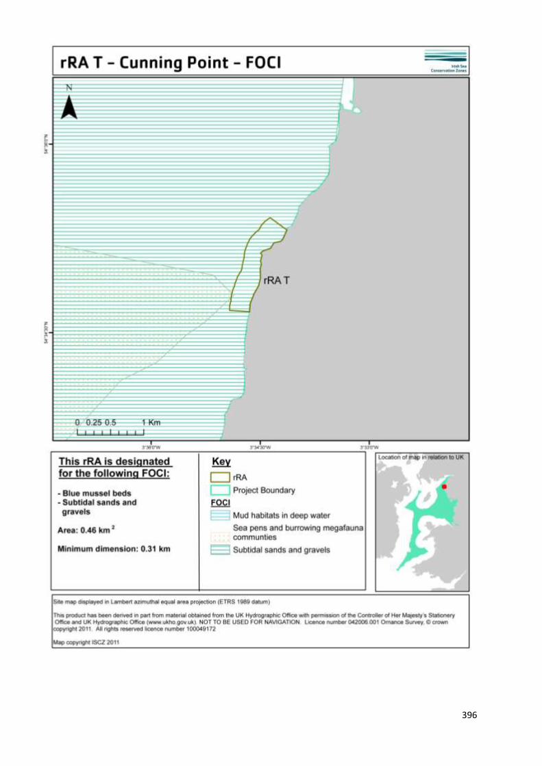
396

397

398
8. Site summary
The rocky shores of the Cumbrian coast provide many ecological niches for organisms to colonise and, for
this reason, they tend to be biologically rich. rRA T is located at Cunning Point on the Cumbrian coast. The
complex structure of this rocky habitat supports a diverse community of flora and fauna. Within the ISCZ
project area there are very few natural rock exposures. Much of the limited hard coastline has been heavily
modified by the dumping of waste from iron, steel and coal industries. The proposed site contains some of
the best examples of moderate energy intertidal rock habitats. This is confirmed by annual coastal surveys
that have been undertaken for the Cumbria Sea Fisheries Committee since 1993.
9. Detailed site description
Cunning Point is an excellent example of a true rocky shore and exhibits an interesting array of habitats
from huge wave cut platforms to mini cliffs, arches, surge gullies and large boulders (Lancaster, 2010).
Cunning Point is also recognized as a Regionally Important Geological and Geomorphological Site (RIGS)
and has some of the best examples of moderate energy intertidal rock habitats within the ISCZ project
area.
Cunning Point and the adjacent rock shores within the recommended reference area are comprised of
extensive exposures of sandstone bedrock of upper Carboniferous age (circa 300 -320 Ma). This bedrock is
present along most of the length of the proposed site from the mid shore to [at least] mean low water.
These include extensive horizontal beds to the south and 2-3 m high vertical and overhanging rock faces
and gullies at and around Cunning Point. Rock pools are common, with a good mix of sizes and depths.
Extensive areas of boulders and cobbles on bedrock are present. Some extensive areas of mobile shingle
are present on mid and lower shores, with signs of abrasion to adjacent areas. The rock pools have not
been directly sampled but have recently been observed. They looked (Lumb, pers. comm.) to support
typical species and there was no evidence was seen of sand smothering or scouring. This supports
Lancaster’s (2010) findings that the previous trend of sand inundation now appears to be reversing.
The width of shore from mean high water spring to mean low water spring is between 75-100m for much
of the site. Cunning Point forms a promontory where the shore is backed by a wider strip of vegetated
shingle and coastal habitat extending back to the railway line. Sections of this coastline have been armored
to protect the railway. Such coast protection works are currently taking place but do not impact the diverse
intertidal zone. The current work is impacting on the upper shore but such impacts are localised and
recovery is likely to be rapid (Lumb pers.comm. 2011 & Lancaster pers. comm. 2011). There are no signs
that the proposed features are in an unfavourable condition and that, therefore, it merits being designated
as a reference area.
At the extreme low water mark there is a kelp zone which is dominated by Oarweed (Laminaria digitata)
and supports the associated plant and animal community common to the kelp patches. Barnacles, tiny seed
mussels and newly established red seaweeds such as Dulse (Palmaria palmata), Irish moss (Chondrus
crispus) and False Irish Moss (Mastocarpus stallatus) dominate the lower shore wave cut platforms.
Toothed wracks (Fucus serratus) were also common but only on the boulders found at the base of the wave
cut platforms. Moving higher up the wave cut platform, the vertices were colonised by barnacles, seed
mussels and algae tucked into crevices. The top of the platforms are characterised by a variety of seaweeds
(Lancaster, 2010).

399
Mid shore, communities of barnacles (Balanus & Chthamalus spp.) and limpets (Patella vulgata)
were found, changing to seaweeds namely bladder wrack (Fucus vesiculosus) and egg wrack
(Ascophyllum nodosum) beneath which barnacles and limpets can be found, including encrusting
red algae. Deep rock pools exhibited toothed wrack (Fucus serratus) and sugar kelp (Laminaria
saccharina). Rock prawns (Palaemon serratus) and shannies (Lipophrys pholis) also frequent the
pools (Lancaster, 2010).
10. Stakeholder and boundary considerations
In order to meet the ENG target, most stakeholders on the RSG accepted the inclusion of rRA T in the final
suite of Reference Areas. For a fuller context on the RSG discussions associated with the selection of
Reference Areas, readers of this report are encouraged to consult meeting reports from the ISCZ RSG
workshops held in May, June and July 2011 (ISCZ, 2011b,c,d).

400
11. Conservation objectives
Conservation Objective
1 Maintain/ recover
Subject to natural change, recover the Moderate Energy Intertidal Rock to reference condition by 2020 and maintain thereafter, such that:
2
Attributes and parameters
the
extent,
diversity,
community structure,
natural environmental quality, and natural environmental processes
Representative of the Moderate Energy Intertidal Rock in the biogeographic region are all recovered.
Advice on operations
3
Human activities
Reference areas should be managed to remove or prevent all extraction, deposition or potentially damaging activities.
Conservation Objective
1 Maintain/ recover
Subject to natural change, recover the Subtidal Mud to reference condition by 2020 and maintain thereafter, such that:
2
Attributes and parameters
the
extent,
diversity,
community structure,
natural environmental quality, and natural environmental processes
Representative of the Subtidal Mud in the biogeographic region are all recovered.
Advice on operations
3
Human activities
Reference areas should be managed to remove or prevent all extraction, deposition or potentially damaging activities.

401
Conservation Objective
1 Maintain/ recover
Subject to natural change, recover the Subtidal Sands and Gravels to reference condition by 2020 and maintain thereafter, such that:
2
Attributes and parameters
the
extent,
diversity,
community structure,
natural environmental quality, and natural environmental processes
Representative of the Subtidal Sands and Gravels in the biogeographic region are all recovered.
Advice on operations
3
Human activities
Reference areas should be managed to remove or prevent all extraction, deposition or potentially damaging activities.

12. Sites to which this site is related
rRA T is not located within an rMCZ or an European Marine Site, the closest site is rMCZ 11 which is
5km to the south, the nearest reference area is rRA J which is 5.6km to the south.
13. Supporting documentation
Information Type of information Source
Intertidal sand and muddy sand
Shore transect surveys MESH, Covey et al. 1998,
Lancaster 2010
References
COVEY, R., FORTUNE, F., NICHOLS, D.M. & THORPE, K.1998. Marine Nature Conservation Review. Sector 11.
Liverpool Bay and the Solway Firth: area summaries. Peterborough, Joint Nature Conservation Committee.
(Coasts and seas of the United Kingdom. MNCR series
ISCZ. 2011b. Meeting report from the 6th Irish Sea Conservation Zones Stakeholder Group meeting. RK
Partnership Ltd.
ISCZ. 2011c. Meeting report from the 7th Irish Sea Conservation Zones Stakeholder Group meeting. RK
Partnership Ltd.
ISCZ. 2011d. Meeting report from the 8th Irish Sea Conservation Zones Stakeholder Group meeting. RK
Partnership Ltd.
LANCASTER, J. 2010. Cumbrian Sea Fisheries Committee shore survey. Solenvo Marine Environmental
Consultants.

403
MARINE CONSERVATION ZONE: SELECTION ASSESSMENT DOCUMENT
RRA W BARROW SOUTH
Version and issue date Amendments made
v1.0 August 2011
1. Site name
rRA W - Barrow South
2. Site centre location
54° 5' 45.253" N, 3° 11' 29.175" W
54.095903 Lat, -3.191437Long. Lambert Azimuthal Equal Area projection, ETRS89 datum
3. Site surface area
0.42 Km2 (42.11 Ha)
4. Biogeographic region
JNCC regional sea: Irish Sea.
OSPAR region III: Celtic Seas.
5. Features proposed for designation within RA W2
Feature type Feature name Area covered within site (for broad
scale habitats and habitats of
conservation importance)
Broad scale habitat A2.3 Intertidal mud
A2.6 Intertidal sediments
dominated by aquatic
angiosperms
0.07 Km2 (6.81 Ha)
0.35 Km2 (35.02 Ha)
Habitat of conservation
importance
Seagrass beds
Species of conservation
importance
-
Geological feature n/a
Other feature n/a

404
6. Features within RA W2 not proposed for designation
Feature type Feature name Reason that feature has not been proposed
for designation
Broad scale
habitat
Habitat of
conservation
importance
Species of
conservation
importance

405
7. Map of site

406

407

408

409
8. Site summary
rRA W has been recommended for designation for the habitat FOCI Seagrass beds. Two species of eelgrass
(Zostera spp.) are found within the site, namely the dwarf eelgrass Zostera noltii and the narrow leaf
eelgrass Zostera angustifolia (English Nature, 2000). This is a particularly important site as the eelgrass
stands found in this region are the only such population within the north west of England (English Nature,
2000). rRA W falls within the Walney Island and Piel Flats SSSI and is also within the Morecambe Bay SAC.
9. Detailed site description
rRA W is situated south of Walney Island and east of Roa Island, in an area known as Westfield. It has been
subject to regular ecological surveys in order to monitor the two waste water outfalls within Walney
channel, one such outflow is onto Roosecote sands, 406 m from rRA W. The area has been closely
monitored (under the E.U. Water Framework Directive) for the discharge impacts on the eelgrass beds, as
an increased abundance of opportunistic ephemeral green algae (e.g. Enteromorpha spp) could have a
negative impact on the eelgrass community (Hubble et al. 2007). Roosecote sands is a heavily used area (by
the MOD, United Utilities, and for maintenance dredging) and the position of rRA: W represents the least
impacted part of the area by anthropogenic activities. The wastewater outfalls are not deemed to be
impacting the site (Hubble et al. 2007, Evans et al., 2008). The southern boundary of the site is delineated
by a buffer zone of ˜ 500 m to enable access to gas and telecommunication infrastructures. Species
diversity greatly increases south of Westfield Point towards Roa Island which demonstrates rich tide swept
communities. However, this area was rejected by the RSG as a possible RA as it is on the edge of an active
dredging site and would, therefore, be inappropriate as a reference area.
Eelgrass beds are ecologically important habitats and play a number of important roles in shallow water
areas. Their extensive horizontal root networks (rhizomes) have a stabilising effect on coastal sediments.
They bind and consolidate sediments, reduce susceptibility to erosion and therefore reduce sediment
transport by currents. Further to this, the leaves promote settlement of sediment (Davidson and Hughes,
1998). Seagrass beds are known to provide shelter to post-larvae and juveniles of some commercial fish
species. They are highly productive habitats and their root systems help to aerate the upper layers of
sediment that can promote inhabitation by some burrowing animals including bivalves and annelid worms
(Davidson and Hughes, 1998). As a reference area it would be worthy of investigating the extent of such
habitat niches, and further quantifying the biodiversity of the site, as the majority of available ecological
data relates to the seagrasses themselves. Seagrasses are also an important food source for overwintering
migratory wildfowl (Davidson and Hughes, 1998).
Roosecote sands illustrate a discontinuous, patchy eelgrass distribution, with a noted increase in density
towards the outer edges of the patches (Hubble et al. 2007). Zostera noltii was found in dense aggregations
to the north and south of the Westfield Point gravel bar, in general no more than ~ 300 m from the shore
line. It was frequently found on slightly raised areas, uncovered at low tide. Z. angustifolia exhibited
considerably less coverage than Z. noltii and was observed only on isolated occasions. Its distribution was
notably more frequent to the south of the gravel bar, but only in small patches. Z. angustifolia was
observed in deeper waters than Z. noltii and rarely exposed at low tide and its range extended out a good
50m further than the extent of Z. noltii. Within rRA W, Zostera noltii is the dominant species. It is
interesting to note that within the impact zone of the outfall there is very little seagrass; the area is
dominated by the ephemeral green algae Enteromorpha spp. (Hubble et al. 2007).

410
Connor et. al. (1997) described the typical infaunal community (creatures living within the sediment) as
associated with the broad-scale habitat of intertidal mud as being characterised by polychaetes such as the
bristle worm Pygospio elegans, lugworm Arenicola marina, and mud shrimps Corophium volutator. Bivalves
such as the common cockle Cerastoderma edule, baltic tellin Macoma balthica and peppery furrow shell
Scrobicularia plana are also present. Typically an epifaunal community (creatures that dwell on the
sediment) includes the mud snail laver spire shell Hydrobia ulvae, shore crabs Carcinus maenas and the
green alga Ulva sp. Such diverse communities have been recorded in the soft sediment invertebrate
surveys conducted by the Natural History Museum within the Westfield area and rRA W (Evans et. al.,
2008).
10. Stakeholder and boundary considerations
In order to meet the ENG target, most stakeholders on the RSG accepted the inclusion of rRA W in the final
suite of Reference Areas. For a fuller context on the RSG discussions associated with the selection of
Reference Areas, readers of this report are encouraged to consult meeting reports from the ISCZ RSG
workshops held in May, June and July 2011 (ISCZ, 2011b,c,d).
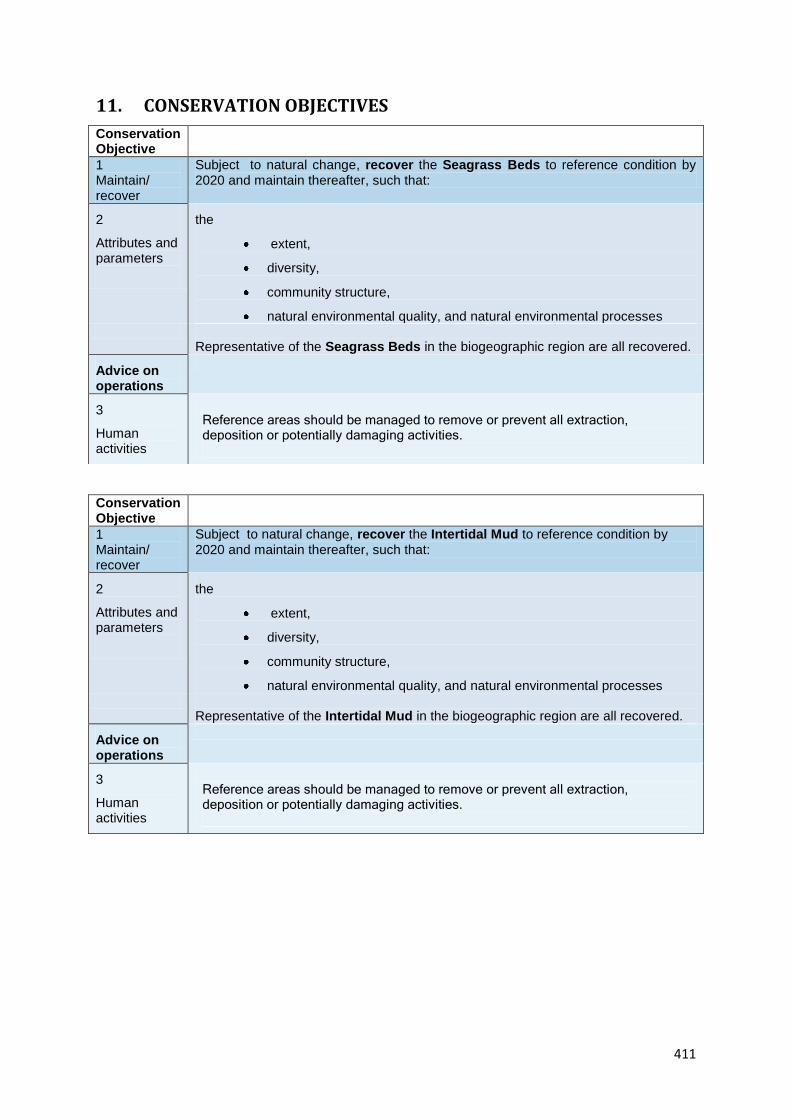
411
11. CONSERVATION OBJECTIVES
Conservation Objective
1 Maintain/ recover
Subject to natural change, recover the Seagrass Beds to reference condition by 2020 and maintain thereafter, such that:
2
Attributes and parameters
the
extent,
diversity,
community structure,
natural environmental quality, and natural environmental processes
Representative of the Seagrass Beds in the biogeographic region are all recovered.
Advice on operations
3
Human activities
Reference areas should be managed to remove or prevent all extraction, deposition or potentially damaging activities.
Conservation Objective
1 Maintain/ recover
Subject to natural change, recover the Intertidal Mud to reference condition by 2020 and maintain thereafter, such that:
2
Attributes and parameters
the
extent,
diversity,
community structure,
natural environmental quality, and natural environmental processes
Representative of the Intertidal Mud in the biogeographic region are all recovered.
Advice on operations
3
Human activities
Reference areas should be managed to remove or prevent all extraction, deposition or potentially damaging activities.

412
Conservation Objective
1 Maintain/ recover
Subject to natural change, recover the Intertidal Sediments dominated by Aquatic Angiosperms to reference condition by 2020 and maintain thereafter, such that:
2
Attributes and parameters
the
extent,
diversity,
community structure,
natural environmental quality, and natural environmental processes
Representative of the Intertidal Sediments dominated by Aquatic Angiosperms in the biogeographic region are all recovered.
Advice on operations
3
Human activities
Reference areas should be managed to remove or prevent all extraction, deposition or potentially damaging activities.

413
12. Sites to which this site is related
rRA W is located within the Morcambe Bay SAC, the closest reference area is rRA Y 5.5km to the
north, this site is also very close (5km) to the Duddon Estuary SAC
13. Supporting documentation
Information Type of information Source
Location of Seagrass beds Intertidal ecological surveys APEM monitoring report for
United Utilities.
Location of Seagrass beds Intertidal ecological surveys Natural History Museum report
for onshore pipeline
environmental development
report.
14. References
Connor, D.W., Brazier, D.P., Hill, T.O., & Northen, K.O., 1997b. Marine biotope classification for
Britain and Ireland. Vol. 1. Littoral biotopes. Joint Nature Conservation Committee, Peterborough,
JNCC Report no. 229, Version 97.06., Joint Nature Conservation Committee, Peterborough, JNCC
Report No. 230, Version 97.06.
Davidson, D.M. & Hughes, D.J. 1998. Zostera Biotopes: An overview of dynamics and sensitivity
characteristics for conservation management of marine SAC’s. Scottish Association for Marine
Science, (UK Marine SACs Project) Available online at: http://www.ukmarinesac.org.uk/zostera.htm
Accessed 25/08/2011.
English Nature. 2000. Morecambe Bay: European marine site English Nature’s advice given under
regulation 33(2) of the Conservation (Natural Habitats &c.) Regulations 1994.
Evans, N.J., Tittley, I., Robbins, R. S., Bamber, R. N., Huxley, R., Campbell, P., Salvador, & Spurrier, C.J.
2008. Natural History Museum Consultancy Report: Rivers fields development onshore pipeline
environmental recovery monitoring programme. Report No. ECM 771E/08.
Fish, J. D., & Fish, S. 2011. A student’s guide to the seashore. Cambridge University Press.
HUBBLE, M., CLOUGH, S., & O’KEEFFE, N. 2007. Roosecote sands eelgrass and ephemeral algae
survey. APEM scientific report for United Utilities.
ISCZ. 2011b. Meeting report from the 6th Irish Sea Conservation Zones Stakeholder Group meeting.
RK Partnership Ltd.
ISCZ. 2011c. Meeting report from the 7th Irish Sea Conservation Zones Stakeholder Group meeting. RK
Partnership Ltd.

414
ISCZ. 2011d. Meeting report from the 8th Irish Sea Conservation Zones Stakeholder Group meeting.
RK Partnership Ltd.

415
MARINE CONSERVATION ZONE: SELECTION ASSESSMENT DOCUMENT
RA Y BARROW NORTH
Version and issue date Amendments made
v1.0 August 2011
1. Site name
rRA Y - Barrow North
2. Site centre location
54° 8' 26.316" N, 3° 15' 26.265" W
54.140643 Lat, -3.257295 Long. Lambert Azimuthal Equal Area projection, ETRS89 datum
3. Site surface area
1.24 Km2 (123.93 Ha)
4. Biogeographic region
JNCC regional sea: Irish Sea.
OSPAR region III: Celtic Seas.
5. Features proposed for designation within rRA Y
Feature type Feature name Area covered within site (for broad
scale habitats and habitats of
conservation importance)
Broad scale habitat A2.3 Intertidal mud
A2.5 Coastal saltmarshes
and saline reedbeds
A5.1 Subtidal coarse
sediments
0.11 Km2 (10.74 Ha)
0.73 Km2 (72.57Ha)
0.14 Km2 (13.87 Ha)
Habitat of conservation
importance
Seagrass beds
Species of conservation
importance
n/a -
Geological feature n/a
Other feature n/a

416
6. Features within rRA: Y not proposed for designation
Feature type Feature name Reason that feature has not been proposed
for designation
Broad scale
habitat
n/a
Habitat of
conservation
importance
n/a
Species of
conservation
importance
n/a

417
7. Map of site

418

419

420

421
8. Site summary
rRA Y is proposed for designation for the broad-scale habitat type coastal saltmarshes and saline
reedbeds and their associated habitats of intertidal muds and subtidal coarse sediments. rRA Y lies
within the north eastern aspect of Walney Channel where it enters the Duddon estuary. The
saltmarshes in this area benefit from a number of marine protected areas: Morecambe Bay cSAC
under the EC Habitats Directive as internationally important examples of this habitat; Duddon
estuary SPA under the EC Directive on the Conservation of Wild Birds for its nationally and
internationally important populations of wintering and passage waders and wildfowl (EN, 1997), and
Duddon estuary SSSI. The Duddon Estuary is also a Ramsar site, one of a series of important
wetlands around the world. The wildlife that has been identified for designation is the natterjack
toad, the rich grouping of wetland plants and invertebrates, and again the wintering waders and
waterfowl and breeding birds. North Walney is also a designated Natural Nature Reserve (NNR).
9. Detailed site description
The saltmarshes within rRA Y are unusual as it contains areas of ungrazed saltmarsh. Survey work
carried out by Natural England (2009) showed that the marsh extent appeared to be stable with the
natural creeks and pans remaining unaltered in comparison with historical aerial photographs (Evans
2009). The site exhibits typical saltmarsh zonation with a relatively species-poor low-mid marsh, and
more diverse communities of the mid-upper marsh. The lower marsh is mostly dominated by sea
purslane Halimione portulacoides, the mid marsh has abundant lax and common sea lavenders
Limonium humile and Limonium vulgare along with a good range of typical saltmarsh indicator
species. There is a small area of upper marsh with common reed Phragmites and sea rush Juncus
maritimus (Evans 2009).
East of the low marsh described above is a fully intertidal area, primarily comprised of mud and sand
habitats. This area is particularly important for birds, particularly wintering waterfowl including:
wildfowl, waders and seabirds such as shelduck Tadorna tadorna, red-breasted merganser Mergus
serrator (although there has been a slight decline in population in recent years; Evans 2010),
oystercatcher Haematopus ostralegus, ringed plover Charadrius hiaticula, and curlew Numenius
arquata.
At the time of writing, Natural England are still awaiting specific, detailed information on the
intertidal mud and sand habitats in this specific area (Evans 2010). Characteristic species in such
habitats have been classified by the JNCC Marine Nature Conservation Review (MNCR) as including
species such as the common cockle Cerastoderma edule, sand-hopper Corophium volutator, laver
spire shell Hydrobia ulvae, ragworm Hediste diversicolor and, when salinity is low, large numbers of
oligochaete annelids (principally Tubificoides spp). With a slight increase in the proportion of sand,
the polychaetes catworm Nephtys hombergi and lugworm Arenicola marina occur. This is, therefore,
diverse and highly productive areas that support important bird populations. Such habitats are also
important fish nursery areas. Within the southern boundary of rRA Y there are also good mussel
Mytilus edulis cobble scars which extend further down into Walney channel (Evans 2010).
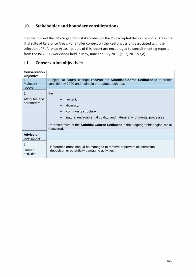
422
10. Stakeholder and boundary considerations
In order to meet the ENG target, most stakeholders on the RSG accepted the inclusion of rRA Y in the
final suite of Reference Areas. For a fuller context on the RSG discussions associated with the
selection of Reference Areas, readers of this report are encouraged to consult meeting reports
from the ISCZ RSG workshops held in May, June and July 2011 (ISCZ, 2011b,c,d).
11. Conservation objectives
Conservation Objective
1 Maintain/ recover
Subject to natural change, recover the Subtidal Coarse Sediment to reference condition by 2020 and maintain thereafter, such that:
2
Attributes and parameters
the
extent,
diversity,
community structure,
natural environmental quality, and natural environmental processes
Representative of the Subtidal Coarse Sediment in the biogeographic region are all recovered.
Advice on operations
3
Human activities
Reference areas should be managed to remove or prevent all extraction, deposition or potentially damaging activities.

423
Conservation Objective
1 Maintain/ recover
Subject to natural change, recover the Coastal Saltmarshes and Saline Reedbeds to reference condition by 2020 and maintain thereafter, such that:
2
Attributes and parameters
the
extent,
diversity,
community structure,
natural environmental quality, and natural environmental processes
Representative of the Coastal Saltmarshes and Saline Reedbeds in the biogeographic region are all recovered.
Advice on operations
3
Human activities
Reference areas should be managed to remove or prevent all extraction, deposition or potentially damaging activities.
Conservation Objective
1 Maintain/ recover
Subject to natural change, recover the Intertidal Mud to reference condition by 2020 and maintain thereafter, such that:
2
Attributes and parameters
the
extent,
diversity,
community structure,
natural environmental quality, and natural environmental processes
Representative of the Intertidal Mud in the biogeographic region are all recovered.
Advice on operations
3
Human activities
Reference areas should be managed to remove or prevent all extraction, deposition or potentially damaging activities.

12. Sites to which this site is related
rRA Y lies within Duddon estuary SPA under the EC Directive on the Conservation of Wild Birds for its
nationally and internationally important populations of wintering and passage waders and wildfowl (EN,
1997), and Duddon estuary SSSI. The Duddon Estuary is also a Ramsar site, one of a series of important
wetlands around the world. The wildlife that has been identified for designation is the natterjack toad, the
rich grouping of wetland plants and invertebrates, and again the wintering waders and waterfowl and
breeding birds. North Walney is also a designated Natural Nature Reserve (NNR).
13. Supporting documentation
Information Type of information Source
Location of saltmarsh
Intertidal surveys MESH
Location and verification of
saltmarsh
Ecological Survey Natural England Duddon
Estuary SSSI (Unit 4 & 6)
References
ISCZ. 2011b. Meeting report from the 6th Irish Sea Conservation Zones Stakeholder Group meeting. RK
Partnership Ltd.
ISCZ. 2011c. Meeting report from the 7th Irish Sea Conservation Zones Stakeholder Group meeting. RK
Partnership Ltd.
ISCZ. 2011d. Meeting report from the 8th Irish Sea Conservation Zones Stakeholder Group meeting. RK
Partnership Ltd.
Evans. 2010.) Duddon Estuary SSSI Unit 4 ID: 1018345 available from
http://www.sssi.naturalengland.org.uk/special/sssi/reportAction.cfm?report=sdrt13&category=S&referenc
e=1000104. Last accessed 28th August 2011
Evans. 2009. Duddon Estuary SSSI Unit 6 ID 1018346 available from
http://www.sssi.naturalengland.org.uk/special/sssi/reportAction.cfm?report=sdrt13&category=S&referenc
e=1000104. Last accessed 28th August 2011

425
MARINE CONSERVATION ZONE: SELECTION ASSESSMENT DOCUMENT
RRA Z SEFTON COAST
Version and issue date Amendments made
v1.0 August 2011
1. Site name
rRA Z - Sefton Coast
2. Site centre location
53° 31' 1.472" N, 3° 3' 48.717" W
53.517075 Lat, -3.063532 Long. Lambert Azimuthal Equal Area projection, ETRS89 datum
3. Site surface area
0.007 Km2 (0.66 Ha)
4. Biogeographic region
JNCC regional sea: Irish Sea.
OSPAR region III: Celtic Seas.
5. Features proposed for designation within rRA Z
Feature type Feature name Area covered within site (for broad
scale habitats and habitats of
conservation importance)
Broad scale habitat n/a
Habitat of conservation
importance
Peat and clay exposures -
Species of conservation
importance
n/a
Geological feature n/a
Other feature n/a

426
6. Features within rRA Z not proposed for designation
Feature type Feature name Reason that feature has not been proposed
for designation
Broad scale
habitat
n/a
Habitat of
conservation
importance
n/a
Species of
conservation
importance
n/a
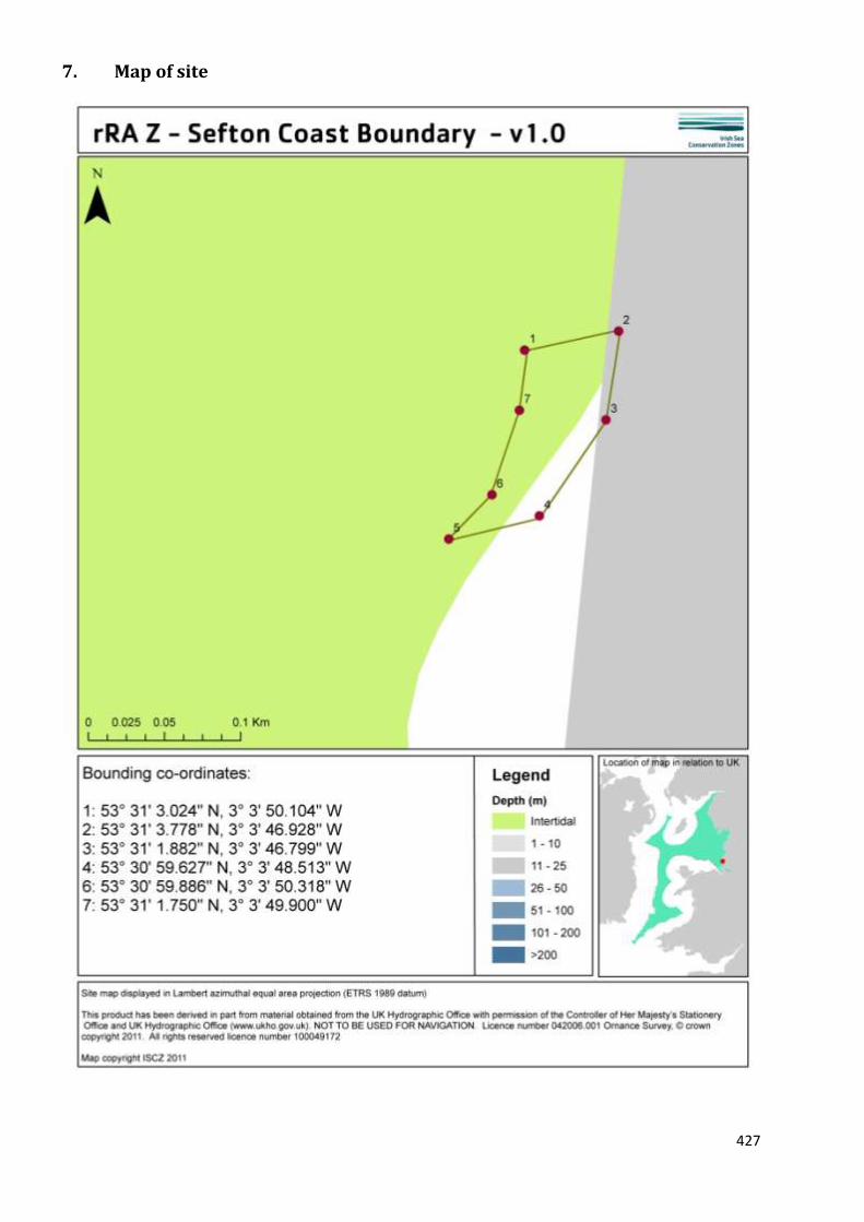
427
7. Map of site

428

429
8. Site summary
rRA Z is situated adjacent to the settlement of Hightown on the Sefton coast. The site is situated in the
intertidal zone, and extends from just above the mean high water mark to the mean low water mark. rRA Z
is proposed for designation for the habitat FOCI peat and clay exposures. Benthic habitats formed from
exposed peat or clay, or in some cases both, are nationally rare and provide important habitats for a variety
of species such as: burrowing bivalves (including piddocks), seaweeds and crabs (NBN Gateway 2011). In
clay rich areas, such as Hightown (Clapham 1999), common mussels, periwinkles and polychaete worms
have also been noted. This habitat feature is also of major archaeological interest, as the exposures are
composed of former lake bed sediments and ancient forested peatland. Designation as a reference area
would help to protect these vulnerable prehistoric landscapes from the threats posed by erosion,
development or recreational pressure.
9. Detailed site description
Peat and clay exposures are a priority habitat for the UK Biodiversity Action Plan (UKBAP) and, although
they are of ecological interest for the habitat itself, they provide for a range of species and are also of
archaeological interest and importance.
The peat and clay exposures present in rRA Z have been verified with data from English Heritage and peer-
reviewed records from the British Geological Society (primarily the Hazell 2008 database) (Clapham 1999;
Seeley et al. 2010).
Protecting these peat and clay exposures will help fulfil the UK commitments to biodiversity through the
UKBAP, for which peat and clay exposures are designated as a priority habitat. Records of piddocks, a type
of burrowing bivalve (Pholas dactylus, Barnea candida and Barnea parva), which are key species for this
habitat type have also been confirmed from the National Biodiversity Network (NBN Gateway, 2011).
These exposures are an irreplaceable habitat type, as they are composed of former lake bed sediments and
ancient forested peatland (also referred to as ‘submerged forests’) (Clapham1999; Maddock 2010).
Peat and clay exposures can be subject to cyclical inundation and exposure by sediment. Depending on the
local level of sand scour, the surface of peat exposures can also become covered with algal mats made of
red and green seaweeds (Ceramium sp. and Ulva lactuca and Ulva intestinalis). Hydroids can be present
within small pools of water and crabs shelter within crevices e.g. Carcinus maenas and Cancer pagurus
(Maddock 2010). On the surface of clay exposures, there tends to be less seaweed coverage, instead small
clumps of blue mussels Mytilus edulis can be present, alongside barnacles and periwinkles Littorina littorea,
whilst polychaete worms live within the clay, e.g. Polydora sp. and Hediste diversicolor (Maddock 2010).
Both peat and clay exposures are soft enough to be burrowed into by piddocks Pholas dactylus, and the
holes created by these burrowing bivalves provide an important micro-habitat for species such as crabs and
anemones, e.g. the daisy anemone (Cereus pedunculatus) and the gem anemone (Aulactinia verrucosa)
(Maddock 2010).
A single radiocarbon date of 4545 ± 90 BP (radiocarbon years before present), which calibrates to about
3,500 to 3,000 calendar years BC, is associated with the peat and forest beds and falls within the Neolithic
period (Stallibrass, pers comm., 2011). The Hightown peat and forest beds are important for the rare
preservation of organic remains (plants and animal fossils) of mid-Holocene growth, and for their
underlying clay deposits. At face value, the date quoted above indicates that the forest/peat growth
occurred during a low sea level stand in the early Neolithic. Subsequently, the relative sea level appears to

430
have risen slowly, with increased sedimentation in the coastal area and an accumulation of off-shore
barriers and sand dunes, which have acted as a major protection against any subsequent high sea levels.
Clapham’s (1999) study of the macrofossils indicates that the peat/forest remains consist of plant remains
of ground flora/understorey. These consist of tall-herb fen vegetation, dominated by the common reed
Phragmites australis, and tall herbaceous vegetation (both common blackberry Rubus fruticosus and
woody nightshade Solanum dulcamara) producing a thick, tangled mass. Closer to the ground, smaller
herbs can be found and, in wetter areas, aquatic species probably grow. At the settlement of Hightown, the
nationally rare royal fern Osmunda regalis forms part of the understorey as well. At Hightown, the
dominant tree was birch, with alder, oak and willow also present but in smaller proportions. Clapham
(1999) noted the presence of other biological remains including, for example, insects such as beetles, and
molluscs. There is, therefore, considerable value in trying to preserve/prevent damage to the Hightown
reference area Z; it supports nationally scarce ecological features and, through continued research, has
potential to provide evidence relevant to important issues such as climate change and our understanding
of changes in relative sea level (Stallibrass, pers. comm., 2011).
The intertidal peat beds along this stretch of coast do not receive protection from the Sefton coast SAC or
SSSI and, therefore, designating these as a feature for a reference area could provide protection against
erosion, recreational activities (such as bait digging) and development.
10. Stakeholder and boundary considerations
In order to meet the ENG target, most stakeholders on the RSG accepted the inclusion of rRA Z in the final
suite of Reference Areas. For a fuller context on the RSG discussions associated with the selection of
Reference Areas, readers of this report are encouraged to consult meeting reports from the ISCZ RSG
workshops held in May, June and July 2011 (ISCZ, 2011b,c,d).

431
11. Conservation objectives
Conservation Objective
1 Maintain/ recover
Subject to natural change, recover the Peat and Clay Exposures to reference condition by 2020 and maintain thereafter, such that:
2
Attributes and parameters
the
extent,
diversity,
community structure,
natural environmental quality, and natural environmental processes
Representative of the Peat and Clay Exposures in the biogeographic region are all recovered.
Advice on operations
3
Human activities
Reference areas should be managed to remove or prevent all extraction, deposition or potentially damaging activities.
432
12. Sites to which this site is related
rRA Z lies within rMCZ 13.rMCZ 13 is adjacent to the Liverpool Bay SPA and situated within the Sefton Coast
SAC/ SSSI. These designations offer no specific management measures to protect the peat and clay
exposures, which is the main reason why the site has been recommended for designation.
As this site is being recommended for the designation of a habitat feature, and one that is primarily of
archaeological interest, rather than a broad-scale habitat type, the distances between this rMCZ and other
rMCZs within the region, which also contain peat and clay exposures, was not considered and is not
reported here.
13. Supporting documentation
Information Type of information Source
Location of peat and clay
exposures
Shoreline Survey MESH
Location of peat and clay
exposures
Survey Hazell for British Geological
Survey (2008)
Location of peat and clay
exposures
Archaeological Survey Clapham (1999) Unpublished
PhD.
References
ISCZ. 2011b. Meeting report from the 6th Irish Sea Conservation Zones Stakeholder Group meeting. RK
Partnership Ltd.
ISCZ. 2011c. Meeting report from the 7th Irish Sea Conservation Zones Stakeholder Group meeting. RK
Partnership Ltd.
ISCZ. 2011d. Meeting report from the 8th Irish Sea Conservation Zones Stakeholder Group meeting. RK
Partnership Ltd.
CLAPHAM, A.J. 1999. The characterisation of two mid-holocene submerged forests. PhD thesis. Liverpool
John Moores University.
HAZELL, Z. 2008. Offshore and intertidal peat deposits, England – a resource assessment and development
of a database. Environmental Archaeology 13: 101-110.
MADDOCK, A. 2010. UK Biodiversity Action Plan; Priority Habitat Descriptions. BRIG (ed. Ant
http://www.ukbap.org.uk/library/UKBAPPriorityHabitatDescriptionsRevised20100730.pdf[Accessed 14
March 2011]
National Biodiversity Network (NBN Gateway) 2011. Available at: http://data.nbn.org.uk/ [Last accessed: 6
April 2011]

433
SEELEY, B., LEAR, D., HIGGS, S., NEILLY, M., BILEWITCH, J., EVANS, J., WILKES, P. & ADAMS, L. 2010.
Accessing and developing the required biophysical datasets and datalayers for Marine Protected Areas
network planning and wider marine spatial planning purposes. Report No 16: Task 2C. Mapping of
Protected Habitats. DEFRA Project Code: MB0102 Marine Biodiversity R&D Program.

434
ANNEXES
The Annexes can be found in the folder of additional information accompanying this report.


