Unit 35 AIDS TO NAVIGATION BUOYA GE SYSTEMS Basic terms • aids to navigation- buoy • spoil ground • radar reflector • groundtackle of a buoy • buoyage system • lateral system • cardinal system • Un ifo rm La teral System • IALA = International Associatio n ofLighthouse Authorities • Sa iling irections • !oast "ilots • marks# cardinal m., lateral m., isolated danger m., safe water m., special m., topmark, p illar-shaped m., spa r shaped m. Aids to Navigation Aids to Navigation are placed along coasts and navigable waters as guides to mark safe water and to assist mariners in determining their position in relation to land and hidden dangers. Each aid to navigation is used to provide specific information. A navigational aid(also known as aid to navigation, AT ON, or navaid) is ansort of marker which aids the traveler in navigation! the term is most commonlused to refer to nautical or aviation travel. "ommon tpes of such aids include lighthouses,buos,fog signals, and dabeacons. According to the glossarof terms in the #$ "oast %uard &ight list , an Aid to Navigation is andevice e'ternal to a vessel or aircraft specificallintended to assist navigators in determining their position or safe course, or to warn them of dangers or obstructions to navigation. $everal aids to navigation are usuallused together to form a local aid to navigation sstem that helps the mariner follow natural and improved channels. $uch aids to navigation also provide a continuous sstem of charted marks for coastal piloting. ndividual aids to navigation are used to mark landfall from seaward, and to mark isolated dangers. ariners mst NOT !"l#on buos alone for determining their position. $torms and wave action can cause buos to move. AT ONs in the US Unlike the roads and highways that we drive on, the waterways we go boating on do not have road signs that tell us our location, the route or distance to a destination, or of hazards along the way. Instead, the waterways have AIDS TO A!I"ATIO#or ATOs$, which are all of those %an&%ade ob'ects used by %ariners to deter%ine (osition or a safe
Transcript
7/23/2019 35-ME-tal
http://slidepdf.com/reader/full/35-me-tal 1/39
Unit 35
AIDS TO NAVIGATION
BUOYAGE SYSTEMS
Basic terms
• aids to navigation - buoy • spoil ground • radar reflector • ground
tackle of a buoy • buoyage system • lateral system • cardinal system
• Uniform Lateral System • IALA = International Association of
• marks# cardinal m., lateral m., isolated danger m., safe water m.,
special m., topmark, pillar-shaped m., spar shaped m.
Aids to NavigationAids to Navigation are placed along coasts and navigable waters as guides to
mark safe water and to assist mariners in determining their position in relation to
land and hidden dangers. Each aid to navigation is used to provide specific
information.
A navigational aid (also known as aid to navigation, ATON, or navaid) is an
sort of marker which aids the traveler in navigation! the term is most commonl
used to refer to nautical or aviation travel. "ommon tpes of such aids includelighthouses, buos, fog signals, and da beacons.
According to the glossar of terms in the #$ "oast %uard &ight list, an Aid to
Navigation is an device e'ternal to a vessel or aircraft specificall intended to
assist navigators in determining their position or safe course, or to warn them of
dangers or obstructions to navigation.
$everal aids to navigation are usuall used together to form a local aid to
navigation sstem that helps the mariner follow natural and improved channels.
$uch aids to navigation also provide a continuous sstem of charted marks for
coastal piloting. ndividual aids to navigation are used to mark landfall from
seaward, and to mark isolated dangers.
ariners mst NOT !"l# on buos alone for determining their position. $torms
and wave action can cause buos to move.
ATONs in the US
Unlike the roads and highways that we drive on, the waterways we go boating on do nothave road signs that tell us our location, the route or distance to a destination, or ofhazards along the way. Instead, the waterways have AIDS TO A!I"ATIO #or ATOs$,
which are all of those %an&%ade ob'ects used by %ariners to deter%ine (osition or a safe
These aids also assist %ariners in %aking a safe landfall, %ark isolated dangers, enable(ilots to follow channels, and (rovide a continuous chain of charted %arks for (recise(iloting in coastal waters. The U.S. Aids to avigation Syste% is intended for use with
nautical charts, which (rovide valuable infor%ation regarding water de(ths, hazards, andother features that you will not find in an atlas or road %a(.
The ter% )aids to navigation) includes buoys, day beacons, lights, lightshi(s, radiobeacons, fog signals, %arks and other devices used to (rovide )street) signs on thewater. Aids To avigation # AtoNav $ include all the visible, audible and electronic sy%bolsthat are established by govern%ent and (rivate authorities for (iloting (ur(oses.
The ter% Aids to Navigation %ust not be confused with the ter% NAVAIDS #navigationaids$ as the latter refers to navigational e*ui(%ent on board shi(. +or clarity and inaccordance with ter%inology used by the International Association of arine Aids toavigation and -ighthouse Authorities #IA-A$, the syste%s (rovided by lighthouse
authorities are described as )aids to navigation #Ato$), to differentiate their (rovisionfro% the e*ui(%ent carried on board shi(s for navigational (ur(oses, which are referredto as navigational aids #avaids$.
Types of Aids to Navigation
The ter% )aids to navigation) enco%(asses a wide range of floating and fied ob'ects#fied %eaning attached to the botto% or shore$, and consist (ri%arily of/
• Buoys & floating ob'ects that are anchored to the botto%. Their distinctive sha(es
and colors indicate their (ur(ose and how to navigate around the%.
• Beacons &0hich are structures that are (er%anently fied to the sea&bed or
land. They range fro% structures such as light houses, to single&(ile (oles. ostbeacons have lateral or non&lateral aids attached to the%. -ighted beacons arecalled )-I"1TS), unlighted beacons are )DA234A5OS).
3oth 3uoys and 3eacons %ay have lights attached, and %ay have a sound %akingdevice such as a gong, bell or horn. 3oth 3uoys and 3eacons %ay be called )%arks).
A marine aid to navigation (AtoN) may be defined as a signaldeliberately placed to provide mariners with information. The signalmay be:
o Visual
o Sound
o Electro magnetic (radio) A!A maritime buoyage
system
A station may be defined as a point on the earth"s surface defined bygeographic coordinates. The following are the categories:
o !and (a fi#ed station accessible by land)
o $ffshore (a fi#ed station only accessible by
boat or helicopter)
o %loating (!ight Vessels& !ight %loats& !argeAutomatic 'avigation uoys& uoys)
7/23/2019 35-ME-tal
http://slidepdf.com/reader/full/35-me-tal 3/39
Several Ato' may be e#hibited or transmitted from a single station andmay comprise one or a number of the following Ato':
o A Daymark andor Topmark (including pole
mar*er beacons& withies& perches)
o Warning Notices e.g. notice boards which mayor may not be illuminated
o Leading Mark (one of at least two separate
daymar* structures that provide a leading line)
o Main light
o Sector light (intensified or unintensified arc of
visibility andor colour either as part of the main lightor provided in addition to the main light& in whichcase the term subsidiary light is commonly used)
o Auxiliary light (a light of noticeable less
intensity than the main light(s))
o Precision Direction Light (a light visible over a
very narrow angle to indicate a direction to befollowed)
o Leading Light (one of at least two lights& which
are situated on at least two separate structures thatprovide a leading line)
o Emergency light (a light introduced upon the
failure of lights& operated by a completely separatepower supply& which may be of noticeable lessintensity than the +ain !ight(s))
o og Signal
o !acon
o !adar Target Enhancer
o Loran " (and other radio navigation systems)
o ,ifferential #PS Signals -
o Automatic dentification Systems (A$S)
7/23/2019 35-ME-tal
http://slidepdf.com/reader/full/35-me-tal 4/39
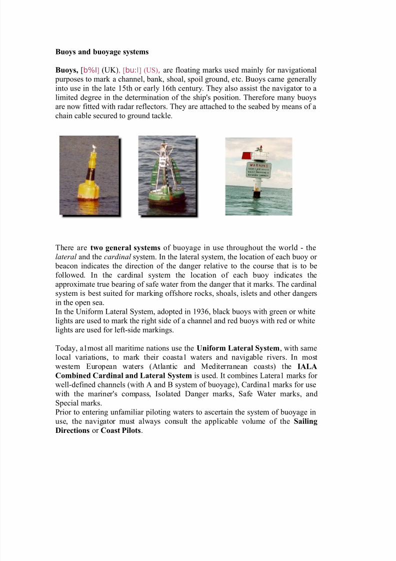
Bo#s and $o#ag" s#st"ms
Bo#s% *b%I+ (#), *bu:I+ (#$), are floating marks used mainl for navigational
purposes to mark a channel, bank, shoal, spoil ground, etc. -uos came generall
into use in the late /th or earl 0th centur. The also assist the navigator to a
limited degree in the determination of the ship1s position. Therefore man buosare now fitted with radar reflectors. The are attached to the seabed b means of a
chain cable secured to ground tackle.
There are t&o g"n"!al s#st"ms of buoage in use throughout the world 2 the
lateral and the cardinal sstem. n the lateral sstem, the location of each buo or
beacon indicates the direction of the danger relative to the course that is to be
followed. n the cardinal sstem the location of each buo indicates the
appro'imate true bearing of safe water from the danger that it marks. The cardinal
sstem is best suited for marking offshore rocks, shoals, islets and other dangersin the open sea.
n the #niform &ateral $stem, adopted in 340, black buos with green or white
lights are used to mark the right side of a channel and red buos with red or white
lights are used for left2side markings.
Toda, amost all maritime nations use the Uni'o!m (at"!al S#st"m, with same
local variations, to mark their coasta waters and navigable rivers. n most
western European waters (Atlantic and editerranean coasts) the IA(A
)om$in"d )a!dinal and (at"!al S#st"m is used. t combines &atera marks for
well2defined channels (with A and - sstem of buoage), "ardina marks for use
with the mariner1s compass, solated 5anger marks, $afe 6ater marks, and$pecial marks.
7rior to entering unfamiliar piloting waters to ascertain the sstem of buoage in
use, the navigator must alwas consult the applicable volume of the Sailing
Di!"ctions or )oast *ilots.
7/23/2019 35-ME-tal
http://slidepdf.com/reader/full/35-me-tal 5/39
5uring the A&A conference in November 389 two navigation marking sstems, ie the S#st"m A (red colour
for the left hand of the ship) and the S#st"m B (red colour for the right hand of the ship), were combined into
one 2 the IA(A S#st"m.
n the A&A $stem the regional (of the sstems A and -) principle of painting of the lateral signs was
maintained. The countries that accepted the red colour for the left hand lateral sings were included in the regionA. The countries that use the green colour for the left hand lateral signs were included in the region -. n the
both regions, the fairwa direction is the one leading from the sea (when a different manner is used than an
ade:uate notice is provided).
;ollowing to the division into the A&A $stem regions, marine maps contain respective notice, ie the <A&A $stem =egion
A< or the <A&A $stem =egion -<.
The International Association of -ighthouse Authorities #IA-A$ buoyagesyste% 6A6. uses five different ty(es of %arks to distinguish safenavigation/
• lateral
• cardinal • isolated danger
• safe water
• s(ecial.
All %arks within the IA-A syste% are distinguished by/
The location of lateral buoys defines the borders of channelsand indicates the direction. Under IALA A red buoys mark theport side of the channel when returning from sea, whereas underIALA B green buoys mark the port side of the channel whensailing towards land. Red buoys hae een numeration plus redlights and green buoys hae odd numeration plus green lights.Lateral lights can hae any calm phase characteristic e!cept "L#$%&'.
(enerally, when two channels meet one will be designated thepreferred channel #i.e. most important channel'. The buoy
depicted on the right indicates the preferred channel to
starboard under IALA A. The light phase characteristic is R "L#$%&')
.
The buoy depicted on the left indicates the preferred channel to
port under IALA A. These buoys are marked with thenumerations of both channels. The light phase characteristic is (
"L #$%&')
7/23/2019 35-ME-tal
http://slidepdf.com/reader/full/35-me-tal 8/39
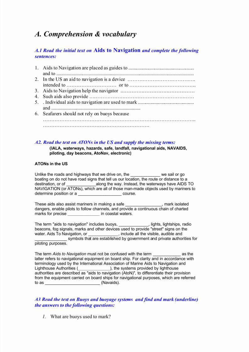
Modi'i"d (at"!al Bo#s and Ma!+s 'o! t," "gion B
7/23/2019 35-ME-tal
http://slidepdf.com/reader/full/35-me-tal 9/39
7ort hand lateral (illar %ark.
7referred channel tostarboard %ark.
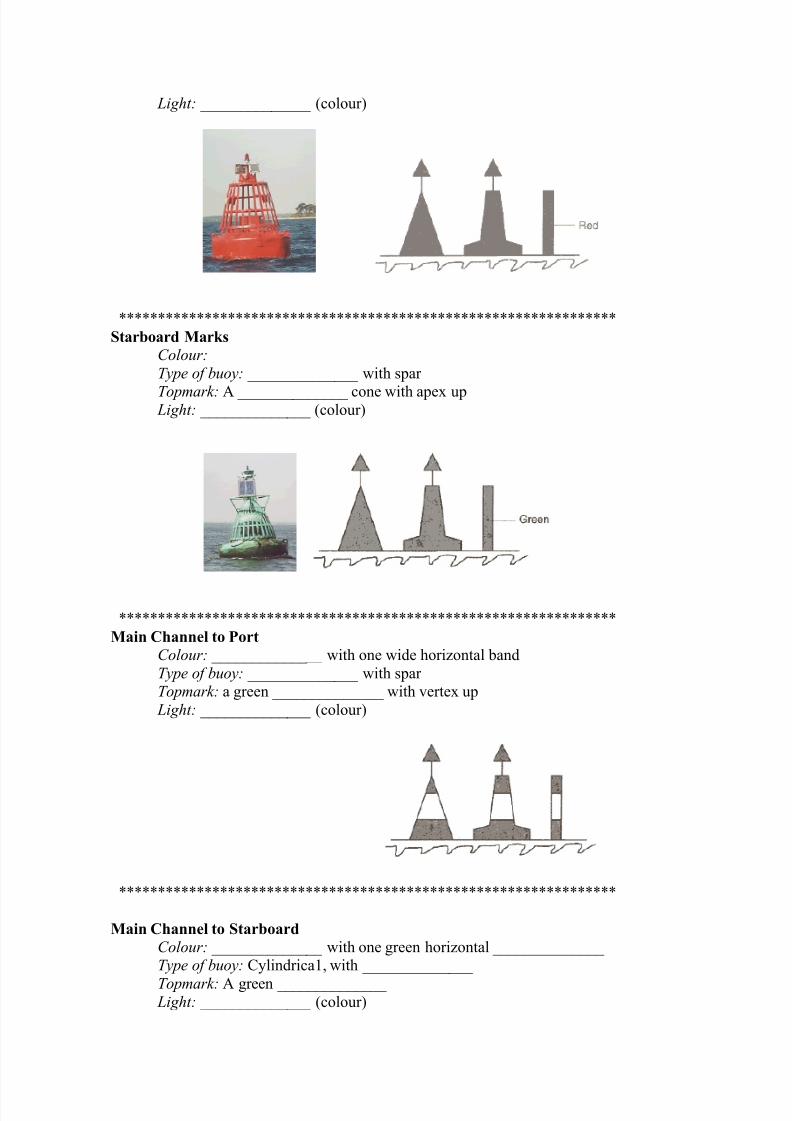
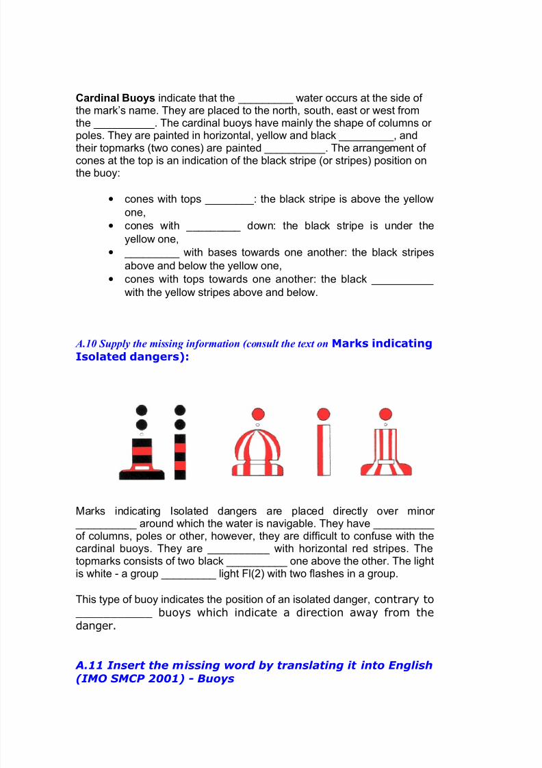
2. Cardinal Buoys
7/23/2019 35-ME-tal
http://slidepdf.com/reader/full/35-me-tal 10/39
The four cardinal buoys indicate the safe side of a danger with ana((roi%ate bearing. +or ea%(le, the 0est cardinal buoy has safe water
on its 0est and the danger on its 4ast side. otice the 6clockwise6rese%blance of the light (hase characteristics. The to(%arks consist of two black triangles (laced in accordance with the black8yellow sche%e of the buoy. 0hen a new obstacle #not yet shown on charts$ needs to be%arked, two cardinal buoys will be used to indicate this 6uncharted6danger. The cardinal syste% is identical in both the IA-A A and IA-A 3buoyage syste%s.
Cardinal Buoys indicate that the dee(est water occurs at the side of the
%ark9s na%e. They are (laced to the north, south, east or west fro% thehazard. The cardinal buoys have %ainly the sha(e of colu%ns or (oles.They are (ainted in horizontal, yellow and black stri(es, and theirto(%arks #two cones$ are (ainted black. The arrange%ent of cones at theto( is an indication of the black stri(e #or stri(es$ (osition on the buoy/
• cones with to(s u(/ the black stri(e is above the yellow one,
• cones with to(s down/ the black stri(e is under the yellow one,
• cones with bases towards one another/ the black stri(es above
and below the yellow one,
• cones with to(s towards one another/ the black stri(e with the
yellow stripes aboe and below.
7/23/2019 35-ME-tal
http://slidepdf.com/reader/full/35-me-tal 11/39
3. Marks indicating Isolated dangers
arks indicating Isolated dangers are (laced directly over %inor obstaclesaround which the water is navigable. The have sha(es of colu%ns, (olesor other, however, they are difficult to confuse with the cardinal buoys.
They are black with horizontal red stri(es. The to(%arks consists of twoblack s(heres one above the other. The light is white & a grou( flash light+l#:$ with two flashes in a grou(.
This ty(e of buoy indicates the (osition of an isolated danger, contrary tocardinal buoys which indicate a direction away from the danger.The light #when present' consists of a white group flash) "l#$'.
4. Marks indicating Safe water
IA-A buoyage syste% A safe water %arks indicate that there is navigablewater all around the %ark for ea%(le %id channel or landfall buoy.
Safe water %ark features/
• colour & red and white vertical stri(es• to( %ark & a single red s(here
7/23/2019 35-ME-tal
http://slidepdf.com/reader/full/35-me-tal 12/39
• light & ehibits a white light, iso(hase, occulting, or single long flashevery ;< seconds
Single flash and a single s(here association %ay hel( you to re%e%ber itscharacteristics.
7/23/2019 35-ME-tal
http://slidepdf.com/reader/full/35-me-tal 13/39
5. Secial Buoys and Marks
These buoys have no actual navigation (ur(ose. ost of the ti%e theseyellow buoys indicate areas used by navies or (i(elines or surfing. IA-Abuoyage syste% A s(ecial %arks indicate a s(ecial area or feature suchas traffic se(aration %arks, s(oil, ground %arks, cable or (i(e lines %arksincluding outfall (i(es. They can also define a channel within a channel,
for ea%(le a channel for dee( draught shi(s in a wide estuary where theli%its of the channel for nor%al navigation are %arked by red and greenlateral buoys.
7/23/2019 35-ME-tal
http://slidepdf.com/reader/full/35-me-tal 14/39
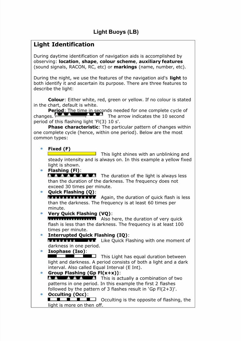
Light Buoys (LB)
Lig!t Identification
*uring daytime identification of naigation aids is accomplished by
obsering) location, s!ae, colour sc!e"e, au#iliary features #sound signals, RA+-, R+, etc' or "arkings #name, number, etc'.
*uring the night, we use the features of the naigation aids lig!t toboth identify it and ascertain its purpose. There are three features to
describe the light)
Colour) /ither white, red, green or yellow. If no colour is stated
in the chart, default is white.$eriod) The time in seconds needed for one complete cycle of
changes. The arrow indicates the &0 secondperiod of this flashing light "l#1' &0 s.
$!ase c!aracteristic) The particular pattern of changes within
one complete cycle #hence, within one period'. Below are the mostcommon types)
%i#ed &%' This light shines with an unblinking and
steady intensity and is always on. In this e!ample a yellow fi!ed
light is shown.%las!ing &%l')
The duration of the light is always lessthan the duration of the darkness. The fre2uency does not
e!ceed 10 times per minute.(uick %las!ing &(')
Again, the duration of 2uick flash is less
than the darkness. The fre2uency is at least 30 times perminute.
)ery (uick %las!ing &)(') Also here, the duration of ery 2uick
flash is less than the darkness. The fre2uency is at least &00times per minute.
Interruted (uick %las!ing &I(')
Like 4uick "lashing with one moment ofdarkness in one period.
Iso!ase &Iso') This Light has e2ual duration between
light and darkness. A period consists of both a light and a darkinteral. Also called /2ual Interal #/ Int'.
*rou %las!ing &* %l&#+#'')
This is actually a combination of twopatterns in one period. In this e!ample the first $ flashes
followed by the pattern of 1 flashes result in (p "l#$%1'.,cculting &,cc')
cculting is the opposite of flashing, thelight is more on then off.
7/23/2019 35-ME-tal
http://slidepdf.com/reader/full/35-me-tal 15/39
-lternating &-L')
An alternating light changes colour. Thisspecial purpose light is typically used for special applications
re2uiring the e!ercise of great caution. In this e!ample ALT.5(
is shown, alternating between green and white.
Morse / &Mo &/'') This light shows two flashes and a
longflash, which is e2uialent to the letter 6U6 in 7orse code.
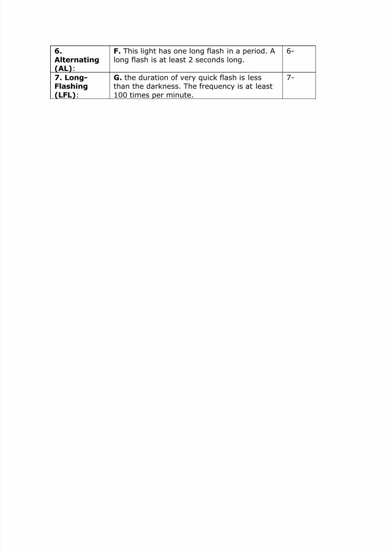
Long0%las!ing &L%L')
This light has one long flash in a period.A long flash is at least $ seconds long.
7/23/2019 35-ME-tal
http://slidepdf.com/reader/full/35-me-tal 16/39
O $TAN5A=5 A=NE "O#N"ATON 7>=A$E$
ll?4.@ 2 NA VIGATIONAL WANING INVOLVING
!.".# - Land- or sea-marks!.".#.# - $efects
... (charted name of light?buo) ... (position) unlit$
... (charted name of light?buo) ... (position) unreliable.
... %charted name of &'o() ... %position) damaged .
... %charted name of light) ... %position) destroyed .
... (charted name of buo) ... (position) off station.
... %charted name of &'o() ... %position) missing .
%og signal at ... (charted name of light) ... (position)
inoperative.
4.@..@ Alterations
... (charted name of light?buo) ... (position) changed to ... (full
characteristics).
... (charted name of light?buo) ... (position) temporarily
changed to ... (full
characteristics ).
... (charted name of buo) ... (position) temporarily removed
(when appropriate). ... (charted name of light) ... (position)temporarily discontinued (when
... (charted name of light?buo) ... (full characteristics)
established in position ... . ... (charted name of light) ... (full
characteristics) re&established in position ... .
... (charted name of light?buo) moved ... (in miles and decimal
miles) ... (direction) to position ... .
4.@.@ 2 $rifting o&+ects
Superbuoy adrift in vicinity ... (position) at ... (date time if
known).
'a(ardous mine adrift in vicinity ... (position) at ... (date time
if known).
Unlit derelict vessel adrift in vicinity ... (position) at ... (date
time if known).
... number) containers adrift in vicinity ... (position) at ... (date
time if known).
7/23/2019 35-ME-tal
http://slidepdf.com/reader/full/35-me-tal 17/39
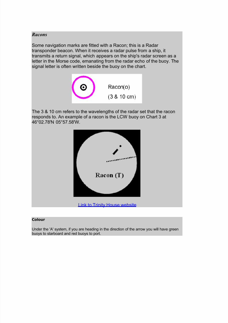
)acons
So%e navigation %arks are fitted with a =acon> this is a =adartrans(onder beacon. 0hen it receives a radar (ulse fro% a shi(, it
trans%its a return signal, which a((ears on the shi(6s radar screen as aletter in the orse code, e%anating fro% the radar echo of the buoy. Thesignal letter is often written beside the buoy on the chart.
The ? @ ;< c% refers to the wavelengths of the radar set that the raconres(onds to. An ea%(le of a racon is the -50 buoy on 5hart ? atBC<:.E6 <FCF.FE60.
-ink to Trinity 1ouse website
Colour
Under the 6A6 syste%, if you are heading in the direction of the arrow you will have greenbuoys to starboard and red buoys to (ort.
Unlike the roads and highways that we drive on, the GGGGGGGGGGGGG we sail or goboating on do not have road signs that tell us our location, the route or distance to a
destination, or of GGGGGGGGGGGGGalong the way. Instead, the waterways have AIDS TOA!I"ATIO #or ATOs$, which are all of those %an&%ade ob'ects used by %ariners todeter%ine (osition or a GGGGGGGGGGGGGGGGGGG course.
These aids also assist %ariners in %aking a safe GGGGGGGGGGGGGGGG, %ark isolateddangers, enable (ilots to follow channels, and (rovide a continuous chain of charted%arks for (recise GGGGGGGGGGGGGG in coastal waters.
The ter% )aids to navigation) includes buoys, GGGGGGGGGGGGG, lights, lightshi(s, radiobeacons, fog signals, %arks and other devices used to (rovide )street) signs on thewater. Aids To avigation, or _____________, include all the visible, audible and GGGGGGGGGGGGGG sy%bols that are established by govern%ent and (rivate authorities for(iloting (ur(oses.
The ter% Aids to Navigation %ust not be confused with the ter% ____________ as thelatter refers to navigational e*ui(%ent on board shi(. +or clarity and in accordance withter%inology used by the International Association of arine Aids to avigation and-ighthouse Authorities #GGGGGGGGGGGGGG$, the syste%s (rovided by lighthouseauthorities are described as )aids to navigation #Ato$), to differentiate their (rovisionfro% the e*ui(%ent carried on board shi(s for navigational (ur(oses, which are referredto as GGGGGGGGGGGGGGGGGGGGGGGG #avaids$.
A3 )ead the te,t on Buoys and buoyage systems and find and mark 2underline
the ans-ers to the follo-ing 4uestions#
#. 6hat are buos used to markC
7/23/2019 35-ME-tal
http://slidepdf.com/reader/full/35-me-tal 19/39
". 6hen did the first buos come into useC
!. >ow are buos attached to the seabedC
. 6hat are the two sstems of buoage todaC
. 6hat does the location of a buo in the lateral sstem indicateC
. 6hat does the location of a buo in the cardinal sstem indicateC
/. 6hat sstem is used in most European countriesC (stud and discuss themap of the world and the buoage sstems)
0. 6hat do black and red buos mark in the #niform &ateral $stem of
buoageC
1. 6hat should the navigator do when entering unfamiliar pilotage watersC
#2. 6hat are pilotage watersC
##. 5iscuss the meaning of the termsD &ank, shoal, spoil gro'nd
#". 6hat is a racon and its characteristicsC (consult the picture and the
accompaning te't)
#!. 6hat is the difference between &'o(s, &eacons and da(marksC
A$7 8atch the term on the left -ith the appropriate definition on the right#
1. %i#ed &%' -. This Light has e2ual duration between
light and darkness. A period consists of botha light and a dark interal. Also called /2ual
Interal #/ Int'.
&8
2. %las!ing
&%l')
B. the opposite of flashing, the light is more
on then off.
$8
3. )ery(uick%las!ing&)(')
C. This light shines with an unblinking and
steady intensity and is always on. In thise!ample a yellow fi!ed light is shown.
18
4. Iso!ase&Iso')
. The duration of the light is always less
than the duration of the darkness. Thefre2uency does not e!ceed 10 times per
minute.
98
5. ,cculting&,cc')
. This light changes colour. This special
purpose light is typically used for special
applications re2uiring the e!ercise of greatcaution. In this e!ample ALT.5( is shown,
alternating between green and white.
:8
7/23/2019 35-ME-tal
http://slidepdf.com/reader/full/35-me-tal 23/39
.-lternating&-L')
%. This light has one long flash in a period. A
long flash is at least $ seconds long.
38
. Long0%las!ing
&L%L')
*. the duration of ery 2uick flash is lessthan the darkness. The fre2uency is at least
&00 times per minute.
;8
7/23/2019 35-ME-tal
http://slidepdf.com/reader/full/35-me-tal 24/39
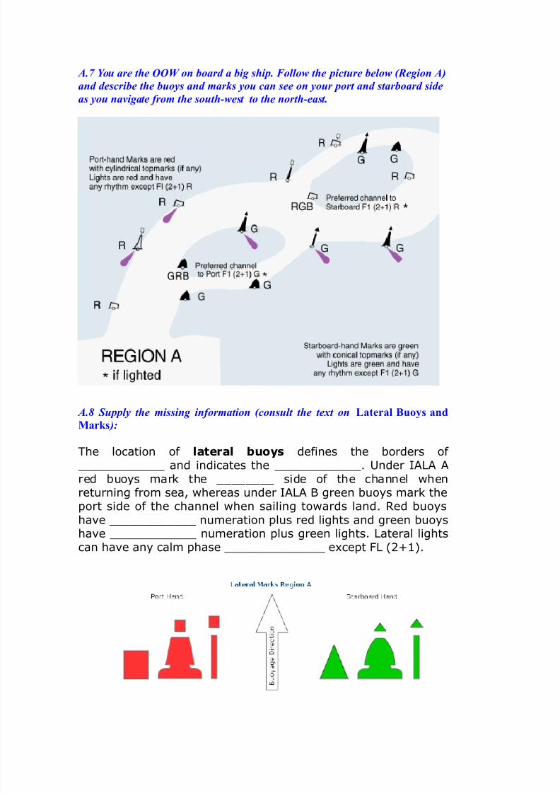
A$9 :ou are the 00; on board a big ship$ %ollo- the picture belo- 2)egion A
and describe the buoys and marks you can see on your port and starboard side
as you navigate from the south&-est to the north&east$
A$< Supply the missing information 2consult the te,t on (at"!al Bo#s andMa!+s #
The location of lateral buoys defines the borders of <<<<<<<<<<<< and indicates the <<<<<<<<<<<<. Under IALA Ared buoys mark the <<<<<<<< side of the channel whenreturning from sea, whereas under IALA B green buoys mark theport side of the channel when sailing towards land. Red buoyshae <<<<<<<<<<<< numeration plus red lights and green buoyshae <<<<<<<<<<<< numeration plus green lights. Lateral lightscan hae any calm phase <<<<<<<<<<<<<< e!cept "L #$%&'.
7/23/2019 35-ME-tal
http://slidepdf.com/reader/full/35-me-tal 25/39
(enerally, when two channels meet one will be designated the <<<<<<<<<<< channel #i.e. most important channel'. The buoydepicted on the right indicates the preferred channel to
____________ under IALA A. The light <<<<<<<<<<<<characteristic is R "L #$%&')
.
The buoy depicted on the left indicates the preferred <<<<<<<<<< to port under IALA A. These buoys are marked withthe numerations of both channels. The light phase characteristicis ( "L #$%&')
A$= Supply the missing information 2consult the te,t on )a!dinal Bo#s #
The four cardinal buoys indicate the GGGGGGGGG side of a danger with ana((roi%ate bearing. +or ea%(le, the 0est cardinal buoy has safe water on its 0est and the GGGGGGGGGGG on its 4ast side. otice the 6clockwise6rese%blance of the light (hase characteristics. TheGGGGGGGGGGGG consistof two black triangles (laced in accordance with the black8yellow sche%eof the buoy. 0hen a new obstacle #not yet shown on charts$ needs to be%arked, two cardinal buoys will be used to indicate this GGGGGGGGGGGG6danger. The cardinal syste% is identical in both the IA-A A and IA-A 3 GGGGGGGGGGG syste%s.
7/23/2019 35-ME-tal
http://slidepdf.com/reader/full/35-me-tal 26/39
Cardinal Buoys indicate that the GGGGGGGGG water occurs at the side ofthe %ark9s na%e. They are (laced to the north, south, east or west fro%the GGGGGGGGGG. The cardinal buoys have %ainly the sha(e of colu%ns or
(oles. They are (ainted in horizontal, yellow and black GGGGGGGGG, andtheir to(%arks #two cones$ are (ainted GGGGGGGGGG. The arrange%ent ofcones at the to( is an indication of the black stri(e #or stri(es$ (osition onthe buoy/
• cones with to(s GGGGGGGG/ the black stri(e is above the yellow
one,
• cones with GGGGGGGGG down/ the black stri(e is under the
yellow one,
• GGGGGGGGG with bases towards one another/ the black stri(es
above and below the yellow one,• cones with to(s towards one another/ the black GGGGGGGGGG
with the yellow stri(es above and below.
A$+> Supply the missing information 2consult the te,t on Marks indicatingIsolated dangers'
arks indicating Isolated dangers are (laced directly over %inor GGGGGGGGGG around which the water is navigable. They have GGGGGGGGGG
of colu%ns, (oles or other, however, they are difficult to confuse with thecardinal buoys. They are GGGGGGGGGG with horizontal red stri(es. Theto(%arks consists of two black GGGGGGGGGG one above the other. The lightis white & a grou( GGGGGGGGG light +l#:$ with two flashes in a grou(.
This ty(e of buoy indicates the (osition of an isolated danger, contrary to <<<<<<<<<<< buoys which indicate a direction away from thedanger.
A.11 Insert the missing word by translating it into English
(IMO SMCP 2001) !"oys
7/23/2019 35-ME-tal
http://slidepdf.com/reader/full/35-me-tal 27/39
O $TAN5A=5 A=NE "O#N"ATON 7>=A$E$
ll?4.@ 2 NA VIGATIONAL WANING INVOLVING
!.".# - Land- or sea-marks
!.".#.# - $efects
... (charted name of light?buo) ... (position) 2be( svi?etla$
... (charted name of light?buo) ... (position) (nepou(dana.
... %charted name of &'o() ... %position) 66666666666666666 % o@teena.
... %charted name of light) ... %position) 66666666666666666 % uni@tena$.
... (charted name of buo) ... (position) 2i(van po(ici?e.
... %charted name of &'o() ... %position) 6666666666666666 % nestala .
%og signal at ... (charted name of light) ... (position) 2ne radi .
4.@..@ Alterations
... (charted name of light?buo) ... (position) 2privremeno
promi?en?enoa u ...
... (charted name of light) ... (position) ( privremenoobustavl?enoa (when appropriate).
... (charted name of light?buo) ... (full characteristics)
( postavl?ena na po(ici?i ... . ... (charted name of light) ... (full characteristics)...
(charted name of light?buo) CCCCCCCCCCCCCC 2prem?e@tenoa ... (in miles and
decimal miles) ... (direction) (na po(ici?u ... .
4.@.@ 2 $rifting o&+ects
'a(ardous mine CCCCCCCCCCCCCC 2pluta in vicinity ... (position) at ... (date
time if known).
Unlit CCCCCCCCCCCCCC 2napu@teni brod adrift in vicinity ... (position) at ...(date time if known).
A$+. /he chunks 2i$e$ groups of -ords in t-o sentences2. and 3 in the te,t
belo- have been ?umbled$ "ut them in the right se4uence$ 2see 1otices to
8ariners 1o$ 3
() %ollowing review of the aids to navigation in the approaches toideford& two additional lighted buoys are to be established as below.(/) indicate / the positions given / the buoys will be established /where it is currently anticipated that /. (0) They will however bepositioned to best advantage after final survey when they are laid.(1) by a further notice to mariners / will be advised/ once they havebeen established / the exact positions of deployment/ .
A$+3 /he -ords of the sentences belo- have been ?umbled$ "ut the in the right
se4uence$ /he first -ord is also the first -ord of the complete sentence$2!onsult the 1otices to 8ariners
7/23/2019 35-ME-tal
http://slidepdf.com/reader/full/35-me-tal 28/39
. 2ave to actuated discontinued whistle be./. The buoy lighted been mar*ing discontinued the wrec* has.0. ,uring 34S planned trials 5amming the ,34S signal from the
lighthouse transmitted unreliable may be.
1. The new with light conical fitted an increased established rangebuoy has been now.
6. A green will topmar* no fitted longer be.7. 'o given will further notice be.
7/23/2019 35-ME-tal
http://slidepdf.com/reader/full/35-me-tal 29/39
B$ Drammar
B$+ Supply the right prepositions#
=emembering alwas the direction . the flood stream, conical buos must
be @. the starboard2hand, can buos must be kept 4. the port hand,
and spherical buos mark the ends B. middle grounds. There are onl two
colours /. a conical buoD black, or black and white checks. There is also
the conical buo with a spar structure and this usuall carries a light, bell or
whistle and often marks the entr 0. a harbour or estuar. t is also painted
black. The can buos, to be kept F. the port band, are painted red, or red
and while.
B$. Supply the ad?ective in brackets in the right place#
The following assumptions are inherent in the provision of Ato'(general):
• 8eliance is not placed on a Ato'. (single)
• Ato' will continue to be re9uired for the foreseeable
future for position fi#ing and for confirmation ofpositionorientation& loo*ing carefully at the mi# toprovide the correct balance between traditional Ato'and new radionavigation systems. (visual)
• $verall& it is envisaged there will be a gradualreduction across the spectrum of traditional Ato' andcomponents& which they support& as a result ofimproved shipboard 'avaid e9uipment fits and theavailability of systems (alernative) owever& it iscurrently envisaged that ma5or changes are to comeinto effect for a number of years. (unlikely )
• light need e#ceed /1 miles nominal range. (no)
• %og signals are provided for ha;ard warning purposes
only.
• aids (such as buoys and light floats) shall not be relied
upon for position fi#ing purposes& (unless the positionsof these are capable of being monitored by a VesselTraffic Service (VTS) or other means are in place toprovide a warning to the mariner that the buoylightfloat is off station. ( floating)
• buoys and beacons should not be deployed in areas
where there is a significant ris* of vessels collidingwith the Ato' station at night. (unlighted )
B$3 "ut the verb in brackets into the right place#
7/23/2019 35-ME-tal
http://slidepdf.com/reader/full/35-me-tal 30/39
All lighted naigation aids either "a6or or "inor lig!ts, wherema=or lights for key naigational points along seacoasts,channels and harbour and rier entrances &are'7 &are used'.
These lights are normally in lightships, lighthouses and other
permanently installed structures, both high intensity and highreliability of the lights &are laced'7 &ro8iding'.
7a=or lights then in primary lights , i.e. ery strong, long rangelights used for the purpose of making landfalls or coastalpassages and secondary lights &are subdi8ided'.
>horter range lights for e!ample at harbour and rier entrances&are found'.
Important details of primary lights in a reference called the LightList &can be found'.
There information about pedestals etc. can be found which not inthe chart &is included'.7inor lights on the other hand are likely within harbours, alongchannels and riers &to be found'.
These hae a low to moderate intensity and sometimes isolateddangers &"ark'.
B$ Supply the missing article -here re4uired 2a 6 an6 the or >#
Attempts to establish international uniform sstem of buoage have never met with
success. sstem proposed in 340 under the auspices of &eague of Nations might have
succeeded had not 6orld 6ar intervened before a sufficient number of maritime $tates had
ratified sstem. buoage sstem adopted for -ritish waters was based on the
340 proposals. sstem called the 1lateral sstem1 is based on knowledge of direction
of the main stream of flood. sides of channels are marked b buos described as
1starboard hand1 or 1port hand1, these terms denoting side that would be on mariner1s
right2hand or left2hand, respectivel, when going with main flood stream or approaching
harbour from seaward.
B$ Supply the missing preposition#
$tarboard2hand buos are conical shape! painted black or black2and2white che:uers!
a top mark (if fitted) of a black cone or a black diamond! and a light (if one is carried) one,
three or five white flashes.
7ort2hand buos are can2shaped! painted red or red2and2white che:uers! a top mark (if
fitted) or a red can or red T! and a light (if one is carried) two, four or si' white flashes.
iddle2ground buos, which mark the ends middle grounds, are spherical shape.
The lights the ma e'hibit are either white or red and distinctive, so that there is no uncertaint as
which side the must be passed. n cases which the main channel lies starboard (when proceeding the main flood stream), or when channels are e:ual
importance, middle2ground buos are painted red2and2white horiHontal bands. cases
7/23/2019 35-ME-tal
http://slidepdf.com/reader/full/35-me-tal 31/39
in which the main channel lies port (when proceeding with the main flood stream) the are
painted black2and2white horiHontal bands. 6hen top marks are carried, if the main channel
lies to starboard (when proceeding the direction the main flood stream) the outer end
middle2ground buo is marked with a red can and the inner end a red T. f the main channel
lies port, the outer end top mark a middle2ground buo is a black cone and the inner
end a black diamond. f the channels are e:ual importance, the outer and inner end buos
are marked a red sphere and a red $t. %eorge1s "ross, respectivel.
!$ ;riting skills
!$+ 7se the following 8'estions as g'idelines to s'mmari9e the reading te:t5
. 6hat are the main uses of buosC
@. 6hich buoage sstems are used todaC
4. 6hat does a buo indicate in the &ateral $stemC
B. 6hat does it indicate in the "ardinal $stemC/. >ow are buos used in the #niform &ateral $stemC
0. 6hat is the most recent sstem of buoage in useC
F. 6hich marks are used in the A&A -uoage $stemC
8. 6hat must a navigator do when entering unfamiliar pilotage watersC
7/23/2019 35-ME-tal
http://slidepdf.com/reader/full/35-me-tal 32/39
Supple&ents
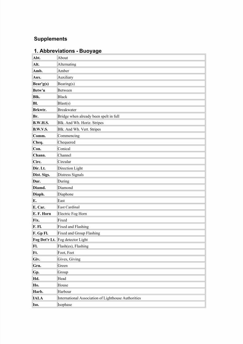
' A%%reviations Buoyage
A$t. About
Alt. Alternating
Am$. Amber
A2. Au'iliar
B"a!3g/s4 -earing(s)
B"t&3n -etween
Bl+. -lack
Bl. -last(s)
B!+&t!. -reakwater
B!. -ridge when alread been spelt in full
B.1.5.S. -lk. And 6h. >oriH. $tripes
B.1.V.S. -lk. And 6h. Iert. $tripes
)omm. "ommencing
),"0. "he:uered
)on. "onical
),ann. "hannel
)i!c. "ircular
Di!. (t. 5irection &ight
Dist. Sigs. 5istress $ignals
D!. 5uring
Diamd. 5iamond
Diap,. 5iaphone
E. East
E. )a!. East "ardinal
E. 6. 5o!n Electric ;og >orn
6i2. ;i'ed
6. 6l. ;i'ed and ;lashing
6. Gp 6l. ;i'ed and %roup ;lashing
6og D"t3! (t. ;og detector &ight6l. ;lash(es), ;lashing
6t. ;oot, ;eet
Giv. %ives, %iving
G!n. %reen
Gp. %roup
5d. >ead
5o. >ouse
5a!$. >arbour
IA(A nternational Association of &ighthouse Authorities
Iso. sophase
7/23/2019 35-ME-tal
http://slidepdf.com/reader/full/35-me-tal 33/39
Isl. sland
Inn. nner
(i'"$t. &ifeboat
(. 6l. &ong ;lashing (a flash at @ seconds or more)
V. 7+. 6l. Ier Juick ;lashing (99 or @9 flashes per minute
1 6est
1. )a!. 6est "ardinal1,. 6hite
18T 6ireless
9 5iagonal "ross
Yd/s4 Kard(s)
%& A%%reviations * Acrony&s
AIS Automatic dentification System
AtoN Aids to 'avigationDE! ,epartment of the Environment Transport and the 8egionsD"#S ,ifferential 3lobal 4ositioning System"$A 3eneral !ighthouse Authority"#S 3lobal 4ositioning System%A arbour Authority%D#& arbours ,oc*s and 4iers <lauses ActIA$A nternational Association of +arine Aids to 'avigation and !ighthouseAuthoritiesI'( nternational +aritime $rganisationI(S nspector of Seamar*s$$A !ocal !ighthouse Authority'SA +erchant Shipping Act
')* +ean Time etween %ailures'! +ean Time To 8estore 'avaids 'avigational aids (shipborne)N&! 'ormal <onditions 8estoredSA&s Special Areas of <onservationS($AS Safety of !ife at Sea% <orporation of Trinity ouse%$S Trinity ouse !ighthouse Service+S,s- Vessel Traffic Service(s)
+ovement to be effected conse9uent upon a recent survey.
'o further notice will be given.
/. Amendment : 2ave actuated whistle to be discontinued.
/ Amendment () : %urther to Trinity ouse 'otice to +ariners => %/ dated 1th April& /==>.The positions of deployment of the two new buoys are as follows:B.. Station : 3rey Sand ill !ighted uoy.
4osition : !atitude 6? =0.760'.& !ongitude =1? /.672../. Station : <row 4oint S !ighted uoy.
Amendment (/) : n addition& the $uter 4ulley !ighted uoy has been moved /6 metres to a newassigned position of !atitude 6? =1.00>'.& !ongitude =1? /.@/=2.
0 Amendment : %ollowing review of the aids to navigation in the approaches to ideford& twoadditional lighted buoys are to be established as below. The positions given indicate where it iscurrently anticipated that the buoys will be established. They will however be positioned to bestadvantage after final survey when they are laid. The e#act positions of deployment will beadvised by a further notice to mariners once they have been established.
1 Amendment: ,uring planned 34S 5amming trials the ,34S signal transmitted from thelighthouse may be unreliable.
6 Amendment : The lighted buoy mar*ing the wrec* has been discontinued.
%ormer 4osition: /C=D about /== metres from the wrec*
'otice is hereby given to all concerned in the ship and the cargo that conse9uent upon thediscontinuance of the buoy mar*ing the wrec*& the <orporation of Trinity ouse has relin9uishedpossession of the wrec* under sections /6/ and /60 of the +erchant Shipping Act @@6.
+ariners are advised that at the time the lighted buoy was discontinued the clearance depth overthe wrec* was /.0 metres !AT
7 Amendment : 'avigation light arc of visibility is now as follows and not as previously
advertised:B
3reen >=.6 deg B /6>.6 deg (C>deg)2hite /6>.6 deg B /7.6 deg (=0 deg)
8ed /7.6 deg B Shore.<haracteristics to remain otherwise unaltered
C. Amendment : +oved to a revised permanent assigned position in!atitude 6D /@".6@0'.& !ongitude =D =C".E
Amendment: The e#isting !ight vessel to be withdrawn and a replacement !ight Vessel to beestablished& as follows:B8ed hull: !ight tower amidships: %l (0) 0= seconds: nominal range 6 miles carried at a height ofat least / metres above the water line: e#hibited during the hours of dar*ness and in periods ofreduced visibility& as follows:B
%og signal giving 0 blasts of / seconds duration every 7= seconds.
8acon& as follows:B
Type : Agile %re9uency<ode : +orse $F'ominal 8ange : = miles%re9uency : G band @0/= +; to @6== +; S band /@/= +; to 0== +;
,isplay period : $n /= seconds.$ff 1= seconds.BBBBBBBBBBBBBBBBBBBBB
Total 7= seconds.BBBBBBBBBBBBBBBBBBBBB+ariners are advised that the above date differs to that previously advertised in Trinity ouse'otice to +ariners 'o.1=/==C E1 dated st August& /==C.
@. Amendment : The lighted buoy mar*ing the wrec* has been discontinuedfollowing complete removal of the wrec*
Amendment : %or a period of about 0 wee*s& the light and daymar* may be partially obscured byscaffolding H sheeting during daylight. There will be no apparent alteration to visibility of thelight during nightime.
. %urther to Trinity ouse 'otice to +ariners '= 0=C dated 6th Iune /==C.
The 3eneral !ighthouse Authorities are establishing a new Enhanced !oran (e!oran) station in<umbria& JK (appro#imate coordinates are !atitude 61? 61.76'. !ongitude ==0? C./02).System verification and calibration will start on or around $ctober and the broadcast signal willbe blin*edF meaning that user receivers should not use the signal. The station will be declared
fully operational around ,ecember when the blin*F will be removed so that user receivers canuse the signal. E#isting !oran receivers may re9uire software upgrades from their e9uipmentsuppliers to use the new signal.
The signals from <umbria will be pulsed& with a 3roup 8epetition nterval of 7C0 (7C&0= microseconds) and an Emission ,elay of /C&0== microseconds. The signals will be modulated withEurofi# data messages with the facility to broadcast both differential !oran corrections andJniversal <oBordinated Time parameters.
+aritime Jsers are strongly encouraged to use !$8A' as a navigational input system to bac*Bupthe widespread use of 34S.
All radio navigation systems are susceptible to interference (including 5amming) andenvironmental effects& which can adversely affect their availability. The 3!As strongly advise
that no single aids to navigation system should be used in isolation and that users should use allalternative means available to cross chec* the information received.
The 3eneral !ighthouse Authorities are committed to the future of e!$8A' as offering aterrestrial radionavigation system without the vulnerability to interference of 34S& and are *eento hear feedbac* from the user community on the performance of e!$8A'.
<%& A$S AS AN A$D T' NA5$#AT$'N---------------------------------------------
+ariners are advised that on or about />th September /==C& AS will be transmitted as an Aid to'avigation at the following Stations:B
2hen observed on the +inimum Keyboard ,isplay (+K,)& the minimum carriage re9uirement forS$!AS vessels& for each Aid to 'avigation the mariner will see:B
++S number'ame
4ositionearing and distance from observer
7/23/2019 35-ME-tal
http://slidepdf.com/reader/full/35-me-tal 38/39
+ariners using certain 8adar and Electronic <hart ,isplays may see a symbol on the display andon interrogation& as a minimum& the above information will be available.f displayed& the screen symbol for an AS Ato' is a diamond shape.
<urrently there is a variance on information that will be displayed by different manufacturers onElectronic <hart and 8adar e9uipment.
4aper charts will have an amendment applied with AS& written in magenta& ad5acent to theAto'.
y $rder&
<aptain ,. 3lass&
,irector of 'avigational 8e9uirements.
Trinity ouse&!ondon E<0' 1,1th September& /==C
0. %urther to Trinity ouse 'otice to +ariners 'o.00=C 30& the new buoy with an increasedlight range has now been established. A green conical topmar* will no longer be fitted.
+ariners are advised that commencing on +onday 7th August& /==C a diving survey will be carriedout in the immediate vicinity of the above position& being the site of the wrec* of a %irst 2orld2ar submarine.
The site lies within the S2 bound lane of the ,over Strait Traffic Separation Scheme& south of theVarne an*.
The survey is e#pected to ta*e 1 days& sub5ect to sea and weather conditions. ,uring theseoperations the Trinity ouse Vessel 3A!ATEA will be stationed over the wrec* and +V +A8 willact as a guardship& stationed south of the Varne an* in the S2 bound lane of the ,over StraitTSS.
8egular roadcasts on the progress of the wor*s will be made through the <hannel 'avigationnformation Service (<'S)& at ,over.
+ariners are re9uested to give the site and the vessels conducting the operations a wide berth.
Amendment: The e#isting !ight vessel to be withdrawn and a replacement !ight Vessel to beestablished& as follows:B
7/23/2019 35-ME-tal
http://slidepdf.com/reader/full/35-me-tal 39/39
8ed hull: !ight tower amidships: %l (0) 0= seconds: nominal range 6 miles carried at a height ofat least / metres above the water line: e#hibited during the hours of dar*ness and in periods ofreduced visibility& as follows:B