Modeling Soil Salinization Processes in Wetlands of the Upper Basin of Devils Lake and in Floodplain Soils along the Sheyenne River, with an Emphasis on the Effects of Alternatives Proposed to Reduce Devils Lake Flooding April 18, 2002 Prepared for: ST. PAUL DISTRICT UNITED STATES ARMY CORPS OF ENGINEERS Task Order Number: DACW37-00-D-004 (2;Partial Fullfillment)) Submitted By: PETERSON ENVIRONMENTAL CONSULTING, INC. 1355 Mendota Heights Road, Suite 100 Mendota Heights, Minnesota 55120 Project Manager: Ronald P. Peterson, J. D. Assistant Project Manager: James L. Arndt, Ph.D., LPSS US Army Corps of Engineers St. Paul District Year 1, Day 1 0 1200 200 400 600 800 1000 Recharge Wetland Year 10, Day 180
Transcript
Modeling Soil Salinization Processes in Wetlands of theUpper Basin of Devils Lake and in Floodplain Soils along the
Sheyenne River, with an Emphasis on the Effects ofAlternatives Proposed to Reduce Devils Lake Flooding
April 18, 2002
Prepared for:
ST. PAUL DISTRICTUNITED STATES ARMY CORPS OF ENGINEERS
Task Order Number: DACW37-00-D-004 (2;Partial Fullfillment))
Submitted By:
PETERSON ENVIRONMENTAL CONSULTING, INC.1355 Mendota Heights Road, Suite 100
Mendota Heights, Minnesota 55120
Project Manager: Ronald P. Peterson, J. D.Assistant Project Manager: James L. Arndt, Ph.D., LPSS
US Army Corpsof EngineersSt. Paul District
Year 1, Day 1
0 1200 200 400 600 800 1000
Recharge Wetland
Year 10, Day 180
Devils Lake Salinity Modeling Executive Summary Page i
EXECUTIVE SUMMARY
The effects of hydrologic alterations on soil salinity are assessed through Hydrus 2D andUNSATCHEM computer modeling simulations of salinization processes in specifichydrogeologic settings. Hydrus 2D simulations were developed for drained and undrainedwetlands in both recharge and discharge hydrologic settings in the Upper Basin of Devils Lake,and in riparian floodplain soils along the Sheyenne River as appropriate to the alternativesproposed to reduce Devils Lake flooding. UNSATCHEM column leaching simulations of theeffects of gypsum on soil salinization processes were run on a typical loam and a typical clayloam soil.
While such modeling efforts illustrate for comparative purposes the general principles andmechanisms of soil salinization associated with the alternatives, they were not developed forpredictive purposes. The principles illustrated in the simulations can be used as a general“guide” in conjunction with previous reports on salinization hazards associated with thealternatives to select drained wetland candidates whose restoration under the Upper BasinStorage alternative will have a minimal salinization effect on adjacent agricultural soils, and toidentify areas along the Sheyenne River that may have salinization problems under theconstructed outlet alternatives.
Simulation of Salinization Processes Associated with Wetland Soils in the Upper Basin
The following conclusions are drawn from the simulations of soil salinization in restoredrecharge and discharge wetlands.
1. A soil salinity hazard requires the presence of high levels of salts near the soil surface. Inthe absence of such accumulations, the restoration of recharge wetlands has a little risk ofsoil salinization. Minor edge-focused salinization typical of that found under naturalconditions was observed in simulation, but not to levels that would result in substantivecrop yield reductions.
2. Drained discharge wetlands typically have substantial amounts of subsoil salts thatconstitute a salinization risk upon restoration. Salts can be mobilized to the surface byincreasing the elevation of water tables adjacent to the restored wetland. Salts can alsopreferentially be transported along sand lenses that can act as a conduit for water flowfrom the restored wetland. Relatively rapid salinization to levels that could reduce cropyields can occur under these circumstances.
Simulation of Salinization Processes in Sheyenne River Floodplain Soils
The following conclusions are drawn from the simulations of soil salinization in Sheyenne Riverfloodplain soils.
1. Poorly and very poorly drained soils on the floodplain of the Sheyenne River accumulatesalts because upward unsaturated groundwater-flow accumulates salts at the surface asevapotranspiration removes pure water. Salinization is greatest in low positions where
Devils Lake Salinity Modeling Executive Summary Page ii
the water table is above a “critical depth.” Salinization of surface soils becomesprogressively less as the depth to the water table increases.
2. In soils with low hydraulic conductivity (e.g. clay loam) the removal of water byevapotranspiration can exceed replacement by groundwater flow from the river, resultingin a groundwater depression during summer where the water levels in floodplain soilsdistant from the river are lower than the river stage.
3. Increasing the stage and salinity of the Sheyenne River can result in additionalsalinization of soils adjacent to the river. However, the data indicate that the increasedsalinization will be primarily confined to soils immediately adjacent to the river whenthose soils have characteristic, low hydraulic conductivity. Data from county soil surveyssuggests that coarse textured soils are relatively rare on the floodplain of the SheyenneRiver.
4. While groundwater intrusion is limited to areas immediately adjacent to the river,increased flooding under the outlet alternatives in shallowly entrenched areas above LakeAshtabula especially could result in a salinization hazard induced by regular floodingpersistently raising water tables.
5. Increased salinization of moderately well-drained floodplain soils on the elevatedfloodplains above the entrenched Sheyenne River downstream of Baldhill Dam isunlikely because the water tables would be well below the critical depth required for soilsalinization.
The Effects of Gypsum on Soil Salinization Processes
Most saline soils in North Dakota contain gypsum to greater or lesser degrees. The presence ofgypsum can increase the salinization hazard of soils subjected to salt mobilization becausecalcium ions released as gypsum dissolves are preferentially adsorbed on soil colloids, replacingexchangeable magnesium and sodium which then add to the salt load in the groundwater. Underthese circumstances the exchange complex, consisting of positively charged cations adsorbed tothe negatively charged surface of soil clays, acts as an additional source of soluble salts.
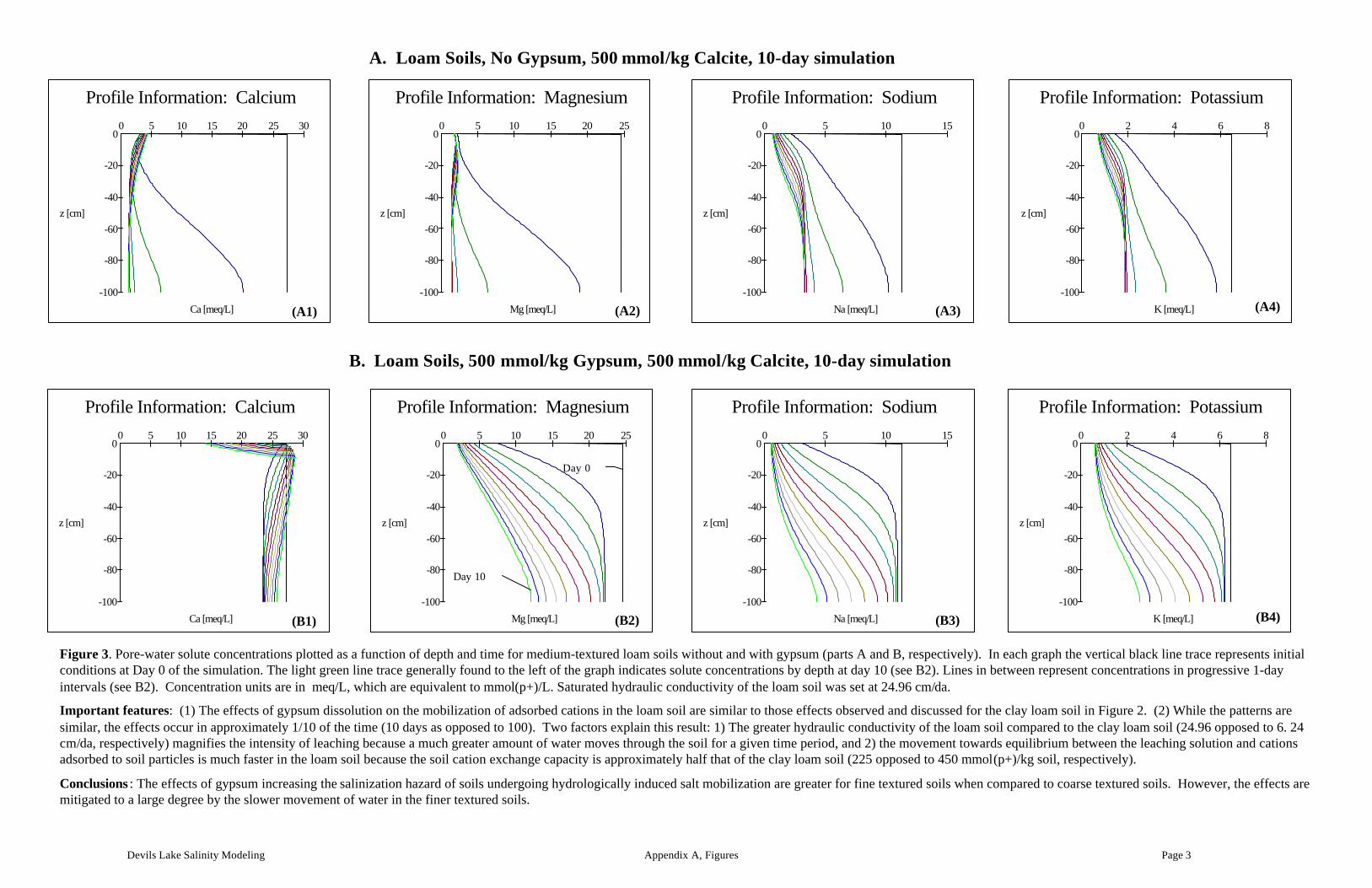
The effects of gypsum dissolution on salinization processes are illustrated through columnleaching simulations of gypsiferous and non-gypsiferous loam and clay loam soils usingUNSATCHEM software. The results confirm that the presence of gypsum results in anadditional salt load produced by the replacement of adsorbed cations by calcium released bygypsum dissolution. While the total amount of additional salt is greater with fine-textured soilsdue to greater total concentrations of adsorbed cations, the effects are mitigated to a large degreeby the lower hydraulic conductivity typical of fine textured soils.
Implications for Modeling and Interpreting Salinization processes Associated with theAlternatives
For the purposes of modeling salinization processes along the Sheyenne River and in UpperBasin wetlands it was assumed that salinity could be modeled using electrical conductivity (EC)or total dissolved solids (TDS) as a single-constituent, non-reactive surrogate for salinity. This
Devils Lake Salinity Modeling Executive Summary Page iii
assumption was appropriate for illustrative purposes and the resulting models simulategeneralized salinization patterns along the Sheyenne River floodplain and in Upper Basinwetlands. However, UNSATCHEM modeling of the effects of gypsum indicated that detailed,predictive modeling of salinization processes must include the effects of gypsum when gypsumis present. The resulting modeling effort necessary to accurately predict salinization processeswith time would be complicated by the requirement that all major solute constituents be includedin the model. The resulting modeling complexity combined with the heterogeneity inherent insoil chemical and physical features and soil gypsum contents would limit the applicability oflarge-scale modeling of salinization processes.
Based on our experience with the salinity simulation models, a detailed model could be run thatincludes laboratory data and actual soil physical and chemical values. However, this effort wasbeyond the scope of the present study. Such detailed work could be performed at representativesites along the Sheyenne River and the Upper Basin of Devils Lake in the future if such effortsare found to be necessary in order to more accurately assess salinization hazards associated withthe alternatives.
Devils Lake Salinity Modeling Page i
TABLE of CONTENTSEXECUTIVE SUMMARY................................................................................................................................................................I
2.1. SOIL SALINITY.................................................................................................................................................................. 12.1.1. The Effects of Gypsum on Soil Salinization Processes...................................................................................2
2.2. SOIL SALINIZATION HAZARDS ASSOCIATED WITH THE UPPER BASIN STORAGE ALTERNATIVE.......................... 22.3. SALINIZATION HAZARDS ASSOCIATED WITH THE OUTLET ALTERNATIVES............................................................. 3
2.3.1. Floodplain soils along the Sheyenne River ......................................................................................................4
3.1. INTRODUCTION TO THE MODELING PROCESS............................................................................................................... 53.1.1. Development of the Finite Element Model .......................................................................................................63.1.2. Boundary Conditions............................................................................................................................................73.1.3. Selection of Initial Conditions............................................................................................................................83.1.4. Assumptions and Simplifications......................................................................................................................103.1.5. Initial and Boundary Conditions......................................................................................................................113.1.6. Model runs ...........................................................................................................................................................13
4. RESULTS AND DISCUSSION.....................................................................................................................................13
Figure 1. Conceptual setting for salinity modeling along an idealized cross-section of theSheyenne River Valley floodplain.
Figure 2. Modeling parameters and initial and boundary conditions for an idealized UpperBasin recharge wetland dominated by Tonka and Hamerly soils, with Svea soilsin the upland.
Figure 3. Modeling parameters and initial and boundary conditions for an idealized UpperBasin discharge-wetland dominated by Hegne, Hamerly, and Hamerly (saline)soils.
Figure 4. Modeling parameters and initial and boundary conditions for an idealizedLamoure-LaDelle-LaPrairie-Ryan soil association typical of fine-textured alluvialsoils on low floodplains of the upper reaches of the Sheyenne River above LakeAshtabula.
Figure 5. Modeling parameters and initial and boundary conditions for an idealizedLaDelle-Ludden-Wahpeton soil association typical of alluvial soils on lowfloodplains of the Sheyenne River above Lake Ashtabula.
Figure 6. Modeling parameters and initial and boundary conditions for an idealizedLaDelle-Ludden-Wahpeton soil association typical of alluvial soils on lowfloodplains of the Sheyenne River above Lake Ashtabula. Simulation includeshigh river-water salinity and a higher river stage.
Figure 7. Modeling parameters and initial and boundary conditions for an idealizedFairdale-LaPrairie-LaDelle soil association typical of alluvial soils on floodplainsof the entrenched Sheyenne river below Baldhill Dam.
Figure 8. Simulated water table configuration, saturation dynamics, and salinity distributionassociated with an idealized restored Upper Basin recharge wetland dominated byTonka and Hamerly soils, with Svea soils in the upland.
Figure 9. Simulated water table configuration, saturation dynamics, and temporal saltdistribution associated with an idealized restored Upper Basin discharge-wetlanddominated by Hegne, Hamerly, and Hamerly (saline) soils.
Figure 10. Simulated water table configuration, saturation dynamics, and salinity distributionassociated with an idealized Lamoure-LaDelle-LaPrairie-Ryan soil associationtypical of fine-textured alluvial soils on low floodplains of the upper reaches ofthe Sheyenne River above lake Ashtabula.
Figure 11. Simulated water table configuration, saturation dynamics, and salinity distributionassociated with an idealized LaDelle-Ludden-Wahpeton soil association typical ofalluvial soils on low floodplains of the Sheyenne River above Lake Ashtabula.
Figure 12. Simulated water table configuration, saturation dynamics, and salinity distributionassociated with an idealized LaDelle-Ludden-Wahpeton soil association typical ofalluvial soils on low floodplains of the Sheyenne River above Lake Ashtabula.Simulation includes high river-water salinity and a high river stage.
Devils Lake Salinity Modeling Page iii
Figure 13. Simulated water table configuration, saturation dynamics, and salinity distributionassociated with salinity modeling of an idealized Fairdale-LaPrairie-LaDelle soilassociation typical of alluvial soils on floodplains of the entrenched SheyenneRiver below Baldhill Dam.
Devils Lake Salinity Modeling Page iv
APPENDICES
Appendix A
Appendix A. UNSATCHEM modeling of the effects of gypsum on soluble salt movement inloam and clay loam soils.
Appendix B. Description of Computer Models Used in the Analysis of Soil SalinizationProcesses
Devils Lake Salinity Modeling Page 1
1. INTRODUCTION
This report supplements two previous reports prepared to assess soil salinization hazardsassociated with the proposed upper basin storage and constructed outlet alternatives to reduceDevils Lake Flood Damage (Peterson Environmental Consulting, Inc., January 22, 2002;Peterson Environmental Consulting, Inc., February 8, 2002, respectively). The reader is directedto these reports for more detailed background information regarding soil salinization than isprovided in the summaries below.
The effects of the alternatives on soil salinity are assessed through computer modelingsimulations of salinization processes in specific hydrogeologic settings. While such modelingefforts illustrate the general principles and mechanisms of soil salinization associated with thealternatives, they were not developed for predictive purposes. The principles illustrated in thesimulations can be used as a general “guide” in conjunction with the aforementioned reports toevaluate potential salinization risks associated with the alternatives proposed to reduce DevilsLake Flooding.
2. BACKGROUND
2.1. SOIL SALINITY
Soluble salts in general are the products of rock and soil weathering processes (Bresler et al.,1982). In the Northern Plains the interaction of near-surface pore water and constituents insurficial sediments results in unique groundwater chemistries dominated by sulfates of calcium,magnesium and sodium (Groenewald et al., 1983; Hendry et al., 1986). Soil salinity in the DevilsLake area and along the Sheyenne River is associated with sodium and magnesium sulfatesreleased through the weathering of shale and dolomite rock constituents of the local glacialsediments and concentrated by evapotranspiration.
Soluble salts are defined as salts more soluble than gypsum (CaSO4.2H2O), which has a
solubility of approximately 2 grams per liter. There are eight ions commonly associated withsoluble salts. Cations consist of calcium (Ca2+), magnesium (Mg2+), sodium (Na+), andpotassium (K+), whereas anions consist of alkalinity (carbonate, CO3
2-; bicarbonate, HCO3-, and
carbonic acid; H2CO3), sulfate (SO42-) and chloride (Cl-). Soil salinity is essentially the sum total
of soluble salts in the soil, generally limited to the root zone, and is operationally defined by theelectrical conductivity of a soil saturation-paste extract (ECspe), expressed in deci-Siemens permeter (dS/m) or micromhos per cm (umho/cm). Total dissolved solids (TDS) expressed asmilligrams solute per liter (mg/L) is also used as a salinity surrogate that reflects the sum ofindividual solutes. Salinity as EC and TDS is related through the relationship:
TDS = 0.65*EC (EC in umho/cm) Equation 1
Elevated salt content in the rooting zone of a soil reduces crop yields by competing with plantsfor water (Bresler et al., 1982). A salinity hazard is generally associated with landscape positions
Devils Lake Salinity Modeling Page 2
characterized by groundwater discharge and shallow water tables (Seelig and Richardson, 1991;Franzen et al., 1994). Soil salinity can be described by the interaction between soil-specific“critical depth” and “critical salinity” parameters. Critical depth is defined as the maximumamount that water tables with a given salinity can rise without resulting in salinization of the soilsurface. Critical salinity is defined as the minimum amount of salt content that near-surfacegroundwater can have without resulting in salinization of the soil surface, regardless of the watertable depth (Maianu, 1981).
A salinity risk is the probability that a salinity hazard will become a problem (Bui et al., 1996).Areas at risk of salinization after alteration of water table dynamics are those areas where storedsalt is likely to be remobilized and redeposited by rising groundwater tables. Assessing the riskof salinization requires an estimate of preexisting hydrology/salinity and the effects of the alteredhydrology induced by elevated water tables.
2.1.1. The Effects of Gypsum on Soil Salinization Processes
Most saline soils in North Dakota contain gypsum to greater or lesser degrees. Gypsum is asparingly soluble salt whose solubility in pure water is approximately 2 grams per liter. Thepresence of gypsum can increase the salinization hazard of soils subjected to salt mobilizationbecause calcium ions released as gypsum dissolves are preferentially adsorbed on the cationexchange complex, replacing exchangeable Mg and Na. The Mg and NA so released can thenadd to the salt load in the groundwater. Thus the exchange complex, consisting of positivelycharged cations adsorbed to the negatively charged surface of soil clays, acts as an additionalsource of soluble salts. Because the exchange complex in fine-textured soils especially canrepresent several grams of potential solute per kilogram of soils, the effects can be significant.The effects of gypsum on soil salinization processes are illustrated in Appendix A using theUNSATCHEM computer model for a clay loam soil. A description of the UNSATCHEM modelis in Appendix B.
2.2. SOIL SALINIZATION HAZARDS ASSOCIATED WITH THE UPPER BASIN STORAGEALTERNATIVE
The Upper Basin of Devils Lake consists of 2616 square miles in 7 North Dakota counties andencompassing 7 major watersheds. Upper Basin topography is dominated by low, undulatingrelief with poorly integrated drainage networks. The majority of the acreage in the Upper Basinis agricultural cropland. Conversion of historic wetlands to agricultural use has resulted in thedrainage of many prairie wetlands in the upper basin of Devils Lake, North Dakota (Kantrud etal., 1989). Saline soils in the Upper Basin are extensive, and are typically associated with wetareas where the groundwater is at or near the surface.
The Upper Basin Storage (UBS) alternative would reduce flooding in Devils Lake by restoringwetlands that have been partially or effectively drained for agriculture, thus enhancing thestorage of water in the upper basin watershed of Devils Lake. Diversions and water-controlstructures may also be used to provide additional storage. The Upper Basin Storage alternativehas the potential to salinize additional lands by raising the water tables in areas adjacent to thestorage wetlands.
Devils Lake Salinity Modeling Page 3
Salt accumulation in North Dakota is associated with specific hydrogeologic settings generallyassociated with groundwater discharge, shallow groundwater depths, and infrequent ponding.Salts accumulate in the vadose (i.e. unsaturated) zone when unsaturated flow brings groundwatercontaining dissolved salts into the rooting zone. The attendant evapotranspirative withdrawal ofpure water leaves the salts to accumulate. Although saline soils are the product of long termhydrogeologic conditions, salts are readily mobilized when recharge/discharge/pondingdynamics change. Many discharge-type wetlands with saline soils at the periphery of the historicwetlands have been drained for agriculture in the Upper Basin. Frequently drainage of dischargetype wetlands results in a mobilization of salts from the surface to the subsoil at the wetlandperiphery where water tables are lowered below the critical depth, and from the subsoil to thesurface in the pond interior where drainage is often imperfect. The resalinization of the soils atthe periphery of the drained historic wetland upon restoration is a possible salinization riskassociated with the restoration of discharge type wetlands in the Upper Basin.
Areas at particular risk are existing, imperfectly drained saline or brackish wetlands or areas thatare adjacent to wetlands that characteristically have a periphery of saline or saline-sodic soils.Some lateral movement will result in the mobilization of salts from the historic wetland edge tothe new edge of the enlarged wetlands. However, it is believed that the majority of thesecondary salinization produced by the upper basin storage alternative will result from amobilization of salts from deep in the profile to the soil surface in areas where the water tablesrise above the “critical depth” (defined in section 2.1).
Not all wetlands will be similarly affected. A considerable number of seasonally pondedwetlands have a groundwater recharge function. Soil profiles in these recharge wetlands aretypically leached and non-saline. Soils on the periphery of these wetlands are frequently non-saline, somewhat poorly drained Aeric Calciaquolls. A lack of stored salt in these soils combinedwith the freshness of the runon-component would reduce the salinity risk associated with therestoration of these wetland types.
Two modeling simulations were run to illustrate soil salinization processes associated with therestoration of recharge and discharge wetlands in the upper basin. The recharge wetlandsimulation consists of an association of Tonka-Hamerly-Svea soils, with Tonka soils occupyingthe wetland, Hamerly soils occupying the wetland periphery, and Svea soils in the uplands.
The discharge wetland simulation consists of Hegne soils in the wetland, and Hamerly andHamerly (saline) soils on the wetland periphery and in somewhat poorly drained positions awayfrom the periphery. A sand lens was incorporated into the simulation to illustrate the effects ofpreferential flow on soil salinization.
2.3. SALINIZATION HAZARDS ASSOCIATED WITH THE OUTLET ALTERNATIVES
The outlet alternatives would alleviate flooding in Devils Lake by releasing under two operatingscenarios 300 or 480 cfs of Devils Lake water (extracted from West Bay) through a constructedoutlet to the Sheyenne River. Discharge to the Sheyenne River at the highest 480 cfs rate(Unconstrained Scenario) would essentially create high-water conditions that would persistthrough the fall depending upon natural base-flow and precipitation characteristics. Discharge atthe lower 300 cfs rate (Constrained Scenario) would be constrained by sulfate water qualitystandards and Sheyenne River channel capacity, and would result in limited over-the-bank
Devils Lake Salinity Modeling Page 4
flooding. The No Action alternative assumes a natural spill from Stump Lake to the SheyenneRiver via the Tolna Coulee. Under the No Action alternative, salinity (as TDS) in the SheyenneRiver downstream of the spill has been predicted to reach levels as high as 3000 mg/L.
Floodplain soils along the Sheyenne River have developed in response to the natural flooding-drawdown hydrology of the Sheyenne River combined with groundwater discharge/rechargerelationships with adjacent aquifers. The quality of Sheyenne River water, while variabledepending upon stage, is fresh as compared to Devils Lake water, and has chemistry usuallydominated by calcium/magnesium bicarbonate. However, mixed river- and lake-water would bemore saline and sodic than it is under existing conditions. Devils Lake water is moderately saline(West Bay salinity is currently ~ 1500 mg/L TDS) with a chemistry dominated by sodium andmagnesium sulfate.
2.3.1. Floodplain soils along the Sheyenne River
Soils along the floodplain of the Sheyenne River are characterized by the presence of moderatelywell drained soils in upland positions and somewhat poorly drained to poorly drained soilsassociated with abandoned meanders and backswamp positions where the river is shallowlyentrenched. Salinity varies, but most of the mapped saline soils are associated with poorly andvery poorly drained positions in the shallowly entrenched reach of the Sheyenne River aboveLake Ashtabula (PEC Report dated February 8, 2001).
There are two salinization risks associated with the constructed outlet alternatives:
(1) Induced floodplain salinization resulting from the raising of water tables of floodplain andadjacent soils above a critical depth. The resultant increase in evapotranspiration in thesurface soil would, in turn, result in an increased concentration of salts that remain after thepure water has been removed.
(2) Additional salt loading to the floodplain could result from both over-bank flooding withmixed Devils Lake/Sheyenne River water and intrusion of this water into adjacent floodplainsoils as infiltrated floodwater and groundwater flow. Seepage outflow of mixed DevilsLake/Sheyenne river water could produce additional salt loading to adjacent floodplain soilsduring periods when the river is contained within the channel.
Under the West Bay outlet alternative with an unconstrained, 480 cfs discharge rate, floodplainsoils adjacent to the Sheyenne River could be frequently inundated spring through fall with moresaline and more sodic water. The hydrologic conditions associated with this scenario couldaffect the salt status of the floodplain soils both by mobilizing existing salts stored in the soil andpossibly by adding new salt.
Persistent flooding would not likely occur under the Constrained Outlet scenario as proposed.However, the combined Devils Lake/Sheyenne River discharge would likely result in alteredinfluent/effluent relationships between the surface water in the river and adjacent groundwatersystems. Under effluent (seepage) conditions associated with the constrained outlet dischargescenarios, seepage outflow from the river and the subsequent movement of this groundwateraway from the channel could result in an increased salinization hazard for susceptible soilsadjacent to the River.
Devils Lake Salinity Modeling Page 5
2.3.1.1. Soil Salinization in the Upper Reach of the Sheyenne River above Lake Ashtabula
The floodplain of the Sheyenne River upstream of Lake Ashtabula is characterized by ashallowly entrenched river channel, a broad active floodplain and extensive areas of relativelyfine textured, poorly and very poorly drained soils occupying backswamp and abandonedmeander positions. Due to these characteristics, the majority of the existing saline soils along theSheyenne River lie upstream of Lake Ashtabula. Three modeling simulations were run on twosoil associations typical of shallowly entrenched portions of the Sheyenne River upstream ofLake Ashtabula. The soil associations investigated include the Lamoure-LaDelle-LaPrairie-Ryan and the LaDelle-Ludden-Wahpeton associations described in PEC report dated February 8,2002. Two modeling simulations assume a relatively high water table with moderately salinesoils in the low positions. A third simulation included higher river water salinity and a higherriver stage.
2.3.1.2. Soil salinization in the lower reach of the Sheyenne River below Baldhill Dam
A more deeply entrenched river and dramatically reduced acreage of poorly and very poorlydrained soils characterizes soil associations downstream of Baldhill Dam. Saline soils are muchless extensive, being restricted largely to recently abandoned meanders on the active floodplain.One modeling simulation was run on the Fairdale-Laprairie-LaDelle association that ischaracteristic of the deeply entrenched portion of the Sheyenne River below Baldhill dam (PECReport dated February 8, 2002). The simulation assumes a relatively deep water table withslightly to moderately saline soils in the low, abandoned meander positions.
3. METHODS
3.1. INTRODUCTION TO THE MODELING PROCESS
The Hydrus 2D and Meshgen 2D programs developed by the staff of the National Soil SalinityLaboratory (Simunek et al., 1999)1 were used to simulate the effects of hydrologic alterationunder the alternatives on water flow and solute transport. A detailed description of the programsis in Appendix B. Simulations were developed for drained and undrained wetlands in bothrecharge and discharge hydrologic settings in the Upper Basin of Devils Lake, and in riparianfloodplain soils along the Sheyenne River.
Interactions between topography, vegetation, climate, surface water, groundwater and soilchemical processes at a given location can not be explicitly modeled due to the complexityinherent in climate and in sediment and solute distributions. However, these processes can beapproximated with conceptual simplifications of the inputs to the model based on field evidence,soil survey data, and applicable literature. Much of the applicable literature on soil-water-salinity interactions is summarized in PEC reports dated January 22, 2002 and February 8, 2002(e.g. Arndt and Richardson, 1988, 1989, 1992, 1993a, 1993b, 1994; Knuteson et al., 1989;
1 Hydrus 2D/Meshgen 2D is distributed by the International Ground Water Modeling Center located at the ColoradoSchool of Mines in Golden, Colorado.
Devils Lake Salinity Modeling Page 6
LaBaugh, 1988; Mills and Zwarich, 1986; Richardson et al., 1991, 1992, Seelig and Richardson,1994).
Three groups of input variables are required to model soil salinization processes using Hydrus2D. The first set of variables provide the initial conditions that represent (1) the topography ofthe landscape in cross-section profile, (2) the hydrologic characteristics of the soil materials, (3)the initial distribution of hydraulic head, and (4) the initial location and concentration of salts.Salts can be provided as individual solutes. However, modeling individual solutes needlesslycomplicates the model and frequently results in long run times and model convergence failures.Salinity includes the aggregate concentrations of individual cations and anions. If informationon an individual solute or solutes is not required, TDS (mg/L) or EC (umho/cm) are frequentlyused as salinity surrogates under the assumption that the aggregate value is conservative (i.e.non-reactive).
The second set of variables defines the boundary conditions necessary to run the finite elementmodel. Boundary conditions describe the rules that govern the movement of water into and outof the model cross-section. Boundary conditions must be defined for the entire perimeter of themodeled area and are discussed in detail in section 3.1.2 below.
The last set of variables includes time dependent conditions that represent changing rainfall andvegetation water-use rates over the duration of the model run time. Also included under timedependent conditions are model characteristics that influence the time-step selection and theiterative process used to evaluate groundwater and solute movement. Time-step and iterationcriteria frequently need to be changed incrementally during model runs in order to get the modelto converge on an answer without failing (crashing).
The modeling process takes initial conditions and then applies a stressor such as increasing themagnitude of groundwater additions or deletions. The effects of the stressors are calculated foreach timestep until a convergence is reached and successive iterations result in insignificantchanges in the parameters of interest determined by comparison to set tolerance levels. For moreinformation see the Hydrus 2D manual (Simunek et al., 1999).
3.1.1. Development of the Finite Element Model
Meshgen 2D discritizes a two-dimensional closed polygon representing a landscape cross-sectioninto discrete elements forming a distribution of nodes that can be attributed with parametersrepresenting initial conditions (discussed below). The effects of the stressors on the parametersof interest are then calculated at each node.
The periphery of the landscape cross-section provides the boundary that must be attributed withappropriate boundary conditions. Landscape cross-sections representing both recharge anddischarge wetlands were developed from an idealized landscape setting representing a relativelygentle slope from the upland to the wetland. The cross-sections represent a 350-by-12 meter“slice” perpendicular to the wetland boundary and extending to the center of the wetland.Examples of the idealized cross-sections are provided for both the recharge simulation and thedischarge simulation in figures cited in section 3.1.5 below.
Devils Lake Salinity Modeling Page 7
Landscape cross-sections applicable to the Sheyenne River were developed from the detailedLidar DEM data provided by the St. Paul District of the USACE. Elevations along a transectdeveloped from the river centerline to the edge of the floodplain were determined in Arcviewusing Spatial Analyst and Profile Extractor extensions. Transect elevations form the topundulating surface of the cross-section. Orthogonal bounding lines were then drawn to form theclosed polygon necessary for discritization. Examples of the idealized cross-sections for both therecharge and the discharge simulations are provided in figures cited below in section 3.1.5.
3.1.2. Boundary Conditions
Simulations developed to model soil salinization processes include the following boundaryconditions. A detailed discussion of boundary conditions is in Franke et al. (1987) and isavailable on the World Wide Web (WWW) at url:
A representative cross-section with appropriate boundary conditions is provided in Figure 1 forreference. Boundary conditions associated with each simulation are provided in the figures citedin section 3.1.5 below.
• No Flow Boundary : A no flow boundary condition represents either an impermeable layeror a streamline or stream-surface boundary across which no water will flow. Manygroundwater models involving lakes, ponds, and streams are set up so that the center of thelake, pond, or stream represents an axis of symmetry across which no water will flow.Recharge and discharge Upper Basin wetlands simulated in this study use the center of thepond and the bottom of the section as no flow boundaries. Similarly, soil salinizationsimulations developed for floodplain settings along the Sheyenne River use the centerline ofthe river and the bottom of the section as no-flow boundaries.
• Variable Head Boundary: A variable head boundary represents a surface where watermovement across the surface changes in response to changes in head in the material adjacentto the boundary. The hydraulic head across a variable head boundary can then changedependent upon time-variable fluxes in water content within the model.
• Atmospheric Boundary: the Atmospheric boundary is also known as a “free surface”boundary. The most common atmospheric boundary is the water table surface at some pointin time. The hydraulic head at the atmospheric boundary is always at atmospheric pressure.However, the position of an atmospheric boundary is not fixed, but is free to vary dependentupon water fluxes into or out of the section being modeled.
• Constant Head Boundary : A constant head boundary is a boundary where the hydraulichead remains constant throughout the simulation. Water sources at constant head boundariesare assumed to be capable of supplying an infinite amount of water to the system such thatthe water levels do not drop under the simulation. The hydraulic heads associated withrivers, lakes, and ponds are frequently assumed to be constant head boundaries.
Devils Lake Salinity Modeling Page 8
• Seepage Face Boundary : A seepage face boundary is a boundary between the saturated flowfield and the atmosphere along which groundwater discharges. The pressure is assumed tobe atmospheric along a seepage face boundary. Any groundwater discharge is assumed to beremoved by flow or evaporation. Seepage-face boundaries become atmospheric boundariesif and when the head becomes negative along part or all of the seepage face due to a loweringof the water table.
3.1.3. Selection of Initial Conditions
Modeling dictates that appropriate initial conditions be selected to represent as accurately aspossible the situation associated with the landforms and substrate being modeled. Initial texturalcharacteristics provided for soils remain constant. However, the initial conditions provided forhydraulic head, solute concentration, and unsaturated flow parameters in the soils vary with timeduring the modeling runs, and indeed are the focus of the simulation. Some initial conditions canbe constant or can vary with time. For example, while root distribution remains constant,transpiration can and does vary with moisture content and solute stress. The Hydrus 2D modelfrequently permits the selection of whether or not such parameters are held constant or areallowed to vary. However, the inclusion of progressively more time-dependent informationresults in longer run times and model destabilization that can, in turn, result in frequentconvergence failures. Because this discussion emphasizes the overall processes, simplificationsand constant conditions were used to the extent possible (discussed in section 3.1.4 below).
3.1.3.1. Soils and substrates
Soil material distribution was based on Natural Resources Conservation Service (NRCS) officialsoil series descriptions (OSDs) for the appropriate area, and knowledge of soil characteristicsobtained from field work, county soil surveys, and applicable literature described in detail inPEC reports dated January 22, 2002 and February 8, 2002. Hydrus 2D includes the Rosettaprogram (see Appendix B) that provides estimates of saturated and unsaturated hydraulicproperties depending upon increasing levels of detail in hydraulic information regarding the soil.For the purposes of the present simulations, all necessary saturated and unsaturated soil hydraulicproperties were based on the soil texture applicable to the soils used in the simulation. Examplesof soils and substrates used for all simulations are provided in figures cited below in section3.1.5.
3.1.3.2. Plant Root Effects
Transpiration by plant roots represents a water loss that occurs within the soil profile that canresult in the concentration of salts to high values within the rooting zone. Hydrus 2D provides amodule to identify the distribution of roots with depth and estimate the amount of watertranspired based on tabulated values for individual crops at varying soil moisture contents. Themodule also permits the entry of individual values relating to crop water use if they are known orare obtained experimentally. Because this report focuses on a comparison of general salinizationprocesses, all simulations used default alfalfa crop water loss values as tabulated in Hydrus 2D.Alfalfa is a common, relatively deep-rooted crop in the Northern Plains that should reflectrealistic plant water-use values.
Devils Lake Salinity Modeling Page 9
Crop water-use can be adversely affected by the amount of solute present in the soil (solutestress). Solute stress was not included as a component of the simulations used in the presentstudy as its inclusion resulted in longer run times and frequent model failures. Examples of theinitial plant root distribution used for all simulations are provided in figures cited below insection 3.1.5.
3.1.3.3. Hydraulic Head
Initial hydraulic head values appropriate to the landscape settings of the simulation were used. Apair of model runs for the Sheyenne River simulations used two different initial hydraulic headand river-water salinity values to simulate the effects of the Sheyenne River stage on soilsalinization processes. Initial head values used in the Upper Basin recharge and dischargewetland simulations reflected the restoration of the pond to the natural conditions. However, thepond stage was set as a constant head boundary in order to facilitate model run time and preventmodel failures. Examples of initial hydraulic heads used for all simulations are provided infigures cited below in section 3.1.5.
3.1.3.4. Solute Concentration
Solute concentrations in soils and surface water were similarly set at realistic values based on thelandscape setting, applicable literature, soil survey data, and field determinations using an EM-38 above-ground soil conductivity meter (Arndt et al., 1987). Solutes were modeled as a singleconservative tracer as a surrogate representing TDS (as ppm) or EC (as mmhos/cm). A pair ofmodel runs used varying concentrations of Sheyenne River water to assess the effects of varyingsalinity under the alternatives. Examples of initial solute concentrations used for all simulationsare provided in figures cited below in section 3.1.5.
3.1.3.5. Precipitation and Evapotranspiration
Time variable conditions in the simulations represent rainfall and crop water-loss data distributedover a 180-day period beginning April 1. This time period was used because it essentiallyrepresents the growing season. Precipitation data represent actual weather data collected fromApril 1, 2001, through September 30, 2001. The data was collected from the Carrington, NorthDakota, weather station obtained from the North Dakota Agricultural Weather Network(NDAWN) Web Site.
Because this report focuses on a comparison of general salinization processes, all simulationsused alfalfa crop water-loss values. To simplify the modeling process the rainfall and crop waterloss (CWL) data daily values were summarized and averaged for each month equaling 30 days.Monthly rainfall values were subtracted from the crop water loss values. This value was thendivided by the days in each representative month. The resulting values represent the net cropwater loss per day over the 180-day run time of the model, and furthermore represent a netprecipitation/evapotranspiration ratio less than one that is characteristic of sub-humid climateswhere evapotranspiration is in excess of precipitation.
Devils Lake Salinity Modeling Page 10
Table 1. Precipitation data used in the simulations
Inches /month Inches per day Meter per dayApril 0.57 0.019 0.000475May 2.11 0.068 0.0017June 4.80 0.16 0.004July 5.61 0.18 0.0045August 1.16 0.037 0.00925September 0.77 0.025 0.000625
Table 2. Crop water use data and net crop water loss
Inches /month Inches per day Meter per day Net CWL1
1Net Crop water-loss (CWL) was calculated as precipitation (as meters per day, Table 1) subtracted from crop wateruse (in meters per day, Table 2).
3.1.4. Assumptions and Simplifications
The following assumptions and simplifications used in the salinity modeling simulations affectthe interpretation of the results to greater or lesser degrees. However, while the effects maychange salinity values, the overall patterns of salinization and the interpretations based on themwould not change.
3.1.4.1. Initial Hydraulic Head Values and Boundary Conditions
Constant head values were used to represent wetlands and river stages where in actuality waterlevels in wetlands and rivers naturally vary. Water levels in recharge wetlands in particularwould normally drop to below the ground surface over the growing season. The assumption of arelatively constant head in discharge wetlands and in the Sheyenne River is a realisticassumption that should average out transient variations that could mask overall trends. Thevarying stages in wetlands and the river would result in changes in the direction of water flowthat, when averaged over time, would result in a net movement in a specific direction. This“averaged” value would better reflect the overall processes of soil salinization and reduce the“noise” provided by transient conditions. With respect to the recharge wetland modeled for theupper basin, reintroducing the initial head conditions that reflect an unsaturated zone sandwichedbetween the pond and the groundwater mound simulates the natural yearly fall-drawdown andspring-recharge condition.
Devils Lake Salinity Modeling Page 11
Constant head boundaries were also used to represent a constant level of groundwater dischargefrom the uplands adjacent to the Sheyenne River. In lieu of actual data indicating otherwise, theassumption of a small amount of discharge from upland positions is realistic given thehydrogeological setting of the Sheyenne River as an underfit stream meandering through a largeglacial valley.
The use of a no flow boundary to represent the center of the wetland and the centerline of theSheyenne River is justified by model symmetry. A no-flow boundary condition was chosen torepresent the bottom of the section which varied in thickness from 12 to 16 meters (40-50 feet)This assumption is realistic given the hydrogeological setting of the river where the majority ofthe groundwater flow would be near the surface.
3.1.4.2. Precipitation and Evapotranspiration
Initial attempts to incorporate daily precipitation, evaporation, and transpiration values resultedin extremely long model run-times and numerous convergence failures. Because the simulationswere designed to illustrate salinization processes in a general and comparative way, the choice ofincorporating precipitation, transpiration, and evaporation into a single number reflective of a netloss of water over the growing season was chosen to more efficiently model salinizationprocesses. The results effectively represent long-term natural conditions whereprecipitation/evapotranspiration ratios are less than one, indicating a net precipitation deficitduring the growing season with recharge occurring during spring. The effects of transientpluvial (wet) conditions on leaching salts downward into the profile is only represented duringspring conditions when high water tables are assumed as an initial condition.
3.1.4.3. Roots
For comparative purposes, the effects of transpiration on solute concentration within the rootzone were modeled using alfalfa, with root densities decreasing from the surface to about 1 meterin depth. In order to simplify model conditions, the effects of solute concentration on crop water-use were not modeled. In actuality, where the simulations predict that concentration values willrise above approximately 4000 units, crop water use will decline due to solute stress. Reducedtransporation would result in lower concentration within the rooting zone and higherconcentrations near the soil surface. However, interpretations of landscape salinization processeswould not be affected to a substantive degree by the lack of a solute stress component in modelsimulations.
3.1.5. Initial and Boundary Conditions
Initial and boundary conditions for all simulations are provided and discussed in Figures 2through 7. Specific details regarding the initial and boundary conditions are provided as textassociated with each figure. Each figure follows the same pattern. The following list explainsthe conditions and parameters provided in the figure text.
Part A. Presents the finite element mesh used to discritize initial conditions and run the model.Part B. Presents the boundary conditions associated with the perimeter of the section.
Devils Lake Salinity Modeling Page 12
Part C. Presents the soils and material distribution attributed for each node in the mesh.Part D. Presents the distribution of roots in the surface.Part E. Presents the initial head distribution.Part F. Presents the initial solute concentration in arbitrary units representative of EC or TDS.
Figure 2. Upper Basin Alternative, Recharge Wetland. Initial and boundary conditions for therecharge wetland simulation represent the restoration of a recharge type wetland with Tonkasoils drained by ditching the center of the wetland. Hamerly soils occupy the wetland periphery,and Svea soils are dominant in the uplands. For greater detail on the salinity and spatialdistribution of these soils, see PEC report dated January 22, 2002.
Figure 3. Upper Basin Alternative, Discharge Wetland. Initial and boundary conditions for thedischarge wetland simulation represent the restoration of a moderately saline discharge wetlanddrained by ditching the center of the wetland. Hegne soils occupy the historic wetland, withHammerly and Hamerly (saline) soils on the wetland periphery and in somewhat poorly drainedpositions away from the wetland periphery. A sand lens has been introduced to evaluate theeffects of preferential flow. For greater detail on the salinity and spatial distribution of thesesoils, see PEC report dated January 22, 2002.
Figure 4. Outlet Alternative, Sheyenne River Upper Reach 1. The initial and boundaryconditions for the simulation represent salinization processes associated with upstream reachesof the Sheyenne River characterized by shallow entrenchment and an association of Lamoure,LaDelle, Laprairie and Ryan soils. Saline soils are common in poorly drained landscapepositions. For greater detail on the salinity and spatial distribution of these soils, see PEC Reportdated February 8, 2002.
Figure 5. Outlet Alternative, Sheyenne River Upper Reach 2. The initial and boundaryconditions for the simulation represent salinization processes associated with upstream reachesof the Sheyenne River that are characterized by shallow entrenchment and an association ofLaDelle, Ludden, and Wahpeton soils. Saline soils are common in poorly drained landscapepositions. For greater detail on the salinity and spatial distribution of these soils, see PEC Reportdated February 8, 2002.
Figure 6. Outlet Alternative, Sheyenne River Upper Reach 3. The initial and boundaryconditions for the simulation use the same initial conditions as those in Figure 5 with theexception that the stage and salinity of the river has been increased (compare Figure 5F withFigure 6F).
Figure 7. Outlet Alternative, Sheyenne River Lower Reach 1. The initial and boundaryconditions for the simulation represent salinization processes associated with downstreamreaches of the Sheyenne River below Baldhill Dam that are characterized by a deepentrenchment and an association of Fairdale, LaPrairie, and LaDelle soils.
Devils Lake Salinity Modeling Page 13
3.1.6. Model runs
Simulations consisted of up to 10 separate runs, one for each of up to 10 successive years;however, salinization patterns are usually evident within 5 years. Each model has a run time of180 days using the initial and boundary conditions and the time variable conditions describedabove and provided in the appropriate figures cited below. The first year simulates therestoration of hydrological processes representative of late spring conditions. For the rechargeand discharge wetland the initial conditions assumed that the wetland was restored to the naturalcondition. Successive years were modeled by importing the year-end (180-day) salinitydistribution from the previous year to be used as the next year’s initial salinity condition. Allsuccessive models used the initial ground water conditions established for the beginning of thefirst year.
4. RESULTS AND DISCUSSION
Results of model runs are presented along with a discussion in Figures 8 through 13. Specificdetails regarding the hydrogeological setting and the specifics of the salinization simulation areprovided as text associated with each figure. Each figure follows the same pattern and isdesigned to act as a stand-alone discussion of the dominant soil salinization characteristics of thesimulation. The following list explains the conditions and parameters provided in the figure text.
Part A. Provides the physical setting and water table configuration of the cross section fordays 1, 90, and 180 of the simulation. Water table configurations for each subsequentsimulation will be the same because year-1 initial hydrologic head conditions areimposed at the beginning of each successive modeling year. Also included areidealized saturated and unsaturated flow direction, and miscellaneous notes anddiscussion applicable to the individual simulation.
Part B. Provides the modeled salinity distribution for a representative series of simulationyears, usually illustrating salinity distribution at Day 1, Year1, day 180 year 1, Day180 year 3, and Day 180, Year 5. Pertinent parameters applicable to the individualsimulation are provided as callouts on the figures and as figure text.
Figure 8. Examines simulated water table configuration, saturation dynamics, and salinitydistribution associated with the modeling of an idealized, restored Upper Basin recharge wetlanddominated by Tonka and Hamerly soils, with Svea soils in the upland.
Figure 9. Examines water table configuration, saturation dynamics, and salinity distributionassociated with the modeling of an idealized, restored Upper Basin discharge wetland dominatedby Hegne and Hamerly soils, with Hamerly (saline) soil variants in the upland position.
Figure 10. Examines water table configuration, saturation dynamics, and salinity distributionassociated with the modeling of an idealized Lamoure-Ladelle-LaPrairie-Ryan soil associationtypical of fine-textured alluvial soils on low floodplains of the upper reaches of the SheyenneRiver above Lake Ashtabula.
Devils Lake Salinity Modeling Page 14
Figure 11. Examines water table configuration, saturation dynamics, and salinity distributionassociated with the modeling of an idealized Ladelle-Ludden-Wahpeton soil association typicalof fine and medium textured alluvial soils on low floodplains of the upper reaches of theSheyenne River above Lake Ashtabula.
Figure 12. Examines water table configuration, saturation dynamics, and salinity distributionassociated with the modeling of an idealized Ladelle-Ludden-Wahpeton soil association typicalof fine and medium textured alluvial soils on low floodplains of the upper reaches of theSheyenne River above Lake Ashtabula. The simulation is similar to that in Figure 11, butincludes high river-water salinity and a higher river stage.
Figure 13. Examines water table configuration, saturation dynamics, and salinity distributionassociated with the modeling of an idealized Fairdale-LaPrairie-LaDelle soil association typicalof alluvial soils on floodplains of the entrenched Sheyenne River below Baldhill Dam.
5. CONCLUSIONS
Hydrus 2D simulations illustrate the processes involved in the movement and accumulation ofsoluble salts in Upper Basin wetlands and in floodplain soils along the Sheyenne River. Thefollowing conclusions are drawn regarding the simulations illustrated in Figures 2-7 and 8-13.
5.1. UPPER BASIN SOIL SALINIZATION SIMULATIONS
1. A soil salinity hazard requires the presence of high levels of salts near the soil surface. Inthe absence of such accumulations, the restoration of recharge wetlands has a little risk ofsoil salinization. Minor edge-focused salinization typical of that found under naturalconditions was observed in simulation, but not to levels that would result in substantivecrop yield reductions.
2. Drained discharge wetlands typically have substantial amounts of subsoil salts thatconstitute a salinization hazard upon restoration. Salts can be mobilized to the surface byincreasing the elevation of water tables adjacent to the restored wetland. Salts can alsopreferentially be transported along sand lenses that can act as a conduit for water flowfrom the restored wetland. Relatively rapid salinization to levels that could reduce cropyields can occur under these circumstances.
5.2. SHEYENNE RIVER SOIL SALINIZATION SIMULATIONS
1. Poorly and very poorly drained soils on the floodplain of the Sheyenne River accumulatesalts because upward unsaturated groundwater-flow accumulates salts at the surface asevapotranspiration removes pure water. Salinization is greatest in low positions wherethe water table is above a “critical depth.” Salinization becomes progressively less as thedepth to the water table increases.
Devils Lake Salinity Modeling Page 15
2. In soils with low hydraulic conductivity (e.g. clay loam) the removal of water byevapotranspiration can exceed replacement by groundwater flow from the river, resultingin a groundwater depression during summer where the water levels in floodplain soilsdistant from the river are lower than the river stage.
3. Increasing the stage and salinity of the Sheyenne River can result in additionalsalinization of soils adjacent to the river. However, the data indicate that the increasedsalinization will be primarily confined to soils immediately adjacent to the river whenthose soils have characteristic, low hydraulic conductivity. Data from county soil surveyssuggests that coarse textured soils are relatively rare on the floodplain of the SheyenneRiver.
4. While groundwater intrusion is limited to areas immediately adjacent to the river,increased flooding under the outlet alternatives could result in a salinization hazardinduced by regular flooding persistently raising water tables
5. Increased salinization of moderately well drained floodplain soils on the elevatedfloodplains above the entrenched Sheyenne River downstream of Baldhill Dam isunlikely because the water tables would be well below the critical depth required for soilsalinization.
Devils Lake Salinity Modeling Page 16
6. REFERENCES
Arndt, J.L., N.D. Prochnow, and J.L. Richardson. 1987. Estimating weighted soil salinity ofmedium textured soil in eastern North Dakota with an aboveground electromagneticinduction meter. Dept. Soil Sci. Res Rpt. No. 32. Agricultural Experiment Station, NorthDakota State University, Fargo, ND 58105.
Arndt, J.L. and J.L. Richardson. 1988. Hydrology, salinity, and hydric soil development in aNorth Dakota prairie pothole wetland system. Wetlands 8:94-108.
Arndt, J.L. and J.L. Richardson. 1989. Geochemical development of hydric soil salinity in aNorth Dakota prairie pothole wetland system. Soil Sci. Soc. Am. J. 53:848-855.
Arndt, J.L. and J.L. Richardson. 1992. Carbonate and gypsum chemistry in saturated, neutral pHsoil environments. In Aquatic Ecosystems in Semi-Arid regions. (R.D. Robarts and M.L.Bothwell (eds.) National Hydrol. Res. Symp. Ser. 7, pp 179-187. Environment Canada,Ottawa, Ont.
Arndt, J.L. and J.L. Richardson. 1993a. Salinity and salinization processes of selected drainedand undrained wetlands in North Dakota. p. 84-102 in Proc. 36th Annual Manitoba SoilSci. Soc. Meeting, Dep. Soil Sci., University of Manitoba, Winnipeg.
Arndt, J.L. and J.L. Richardson. 1993b. Temporal variations in the salinity of shallowgroundwaters collected from the periphery of some North Dakota USA wetlands. J.Hydrol. 141:75-105.
Arndt, J.L. and J.L. Richardson. 1994. Impacts of groundwater flow systems on hydric soils ofthe glaciated northern prairies of the U.S. p. 64-84. Proceed. 37th Ann. Manitoba SoilScience Society Meetings, Jan. 4-6, 1994, Winnipeg, Manitoba, Canada.
Bresler, E., B. L. McNeal, and D. L. Carter. 1982. Saline and sodic soils: Principles – Dynamics– Modeling. Springer-Verlag, New York. 236 pp.
Bui, E. N., K. R. J. Smettem, C. J. Moran, and J. Williams. 1996. Use of Soil Survey Data toAssess Regional Salinization Risk Using Geographical Information Systems. J. Environ.Qual. 25:433-439.
Franke, O.L., T.E. Reilly, and G.D. Bennett. 1987. Definition of boundary and initial conditionsin the analysis of saturated ground-water flow systems – an introduction. In Techniquesof Water-Resources Investigations of the United States Geological Survey. Book 3Applications of Hydraulics, Chapter 5. US Government Printing Office, Washington,D.C.
Franzen, D., C. Fanning and T. Gregoire. 1994. Managing saline soils in North Dakota. NorthDakota State University Extension Publ. SF-1087. Fargo, 11 pp.
Groenewald, G. H., R. D. Koob, G. J. McCarthy, B. W. Rehm, and W. M. Peterson. 1983.Geological and Geochemical Controls on the Chemical Evolution of Subsurface Water in
Devils Lake Salinity Modeling Page 17
Undisturbed and Surface-Mined landscapes in Western North Dakota. ND Geol. Surv.Report of Inverstigation No. 79. ND Geol. Surv., Bismarck, ND.
Hendry, M. J., J. A. Cherry, and E. I. Wallick. 1986. Origin and distribution of sulfate in afractured till in Southern Alberta, Canada. Water Resources Res.. 22:45-61.
Kantrud, Harold A., Gary L. Krapu, and George A. Swanson. 1989. Prairie basin wetlands of theDakotas: A community profile. U. S. Fish and Wildlife Service, Biological Report85(7.28). Jamestown, ND: Northern Prairie Wildlife Research Center Home Page.http://www.npwrc.usgs.gov/resource/othrdata/basinwet/basinwet.htm Version 16JUL97).
Knuteson, J.A., J.L. Richardson, D.D. Patterson, and L. Prunty. 1989. Pedogenic carbonates in aCalciaquoll associated with a recharge wetland. Soil Sci. Soc. Am. J. 53:495-499.
LaBaugh, J. W. 1988. Relation of hydrogeologic setting to chemical characteristics of selectedlakes and wetlands within a climate gradient in the North-Central United States. Verh.Iternat. Verein. Limnol. 23:131-137.
Maianu, A. 1981. Saline and sodic soils: Genesis and properties of saline and sodic soils,methods of reclamation and management practices for crop production. Course Notes forSoil Science 442 North Dakota State University, Fargo, ND.
Mermut, A.R., and M.A. Arshad. 1987. Significance of sulfide oxidation in soil salinization insoutheastern Saskatchewan, Canada. Soil Sci. Soc. Am. J. 51:247-251.
Mills, J.G. and M.A. Zwarich. 1986. Transient groundwater flow surrounding a recharge sloughin a till plain. Can. J. Soil Sci. 66:121-134.
Peterson Environmental Consulting, Inc. January 22, 2002. Soil salinization hazards associatedwith Devils Lake flood damage reduction alternatives: Sheyenne River Valley. TaskOrder Number DACW37-00-D-004 (2). U.S. Army Corps of Engineers, St. Paul District.St. Paul, MN.
Peterson Environmental Consulting, Inc. February 8, 2002. Soil salinization hazards associatedwith Devils Lake flood damage reduction alternatives: Upper Basin Storage Alternative.Task Order Number DACW37-00-D-004 (2). U.S. Army Corps of Engineers, St. PaulDistrict. St. Paul, MN.
Richardson, J. L., D. G. Hopkins, B. E. Seelig, and M. D. Sweeney. 1991. Salinity development,recognition, and management in North Dakota soils. In Kimble, J. M. (ed.), Proceedingsof the International Soil Correlation Meeting (VI. ISCOM): Characterization,Classification, and Utilization of Cold Aridisols and Vertisols. p.159-165.
Richardson, J.L., L.P. Wilding, and R.B. Daniels. 1992. Recharge and discharge of groundwaterillustrated with flownet analysis. Geoderma 53:65-78.
Seelig, B. D. and J. L. Richardson. 1994. Sodic Soil toposequence related to focused water flow.Soil Sci. Soc. Am. J. 58156-163.
Seelig, B.D. and J.L. Richardson. 1991. Salinity and sodicity in North Dakota soils. NorthDakota State University Ext. Serv. Publ. EB 57, Fargo ND.
Devils Lake Salinity Modeling Page 18
Simunek, J., M. Sejna, and M. Th. Van Genuchten. 1999. Hydrus-2D/Meshgen-2D. Simulatingwater flow and solute transport in two-dimensional variably saturated media. TPS-53C,International Groundwater Modeling Center, Coloraqdo School of Mines, GoldenColorado.
Figures
Devils Lake Salinity Modeling Figures Page 1
Figure 1. Conceptual setting for salinity modeling along an idealized cross-section of the Sheyenne River Valley floodplain. Thisfigure was discussed with the staff of the NSSL, Riverside California to ensure appropriate concepts, boundary conditions, and initialconditions were used for the Hydrus 2D modeling. Note that boundary conditions have been set for the entire perimeter of the section.Note floodplain geomorphology and placement of the natural levee and the abandoned meander. The cross section would berepresentative of the shallowly entrenched reach of the Sheyenne River above Lake Ashtabula.
Natural Levee
Abandoned Meander
ETPPT
ET > PPT
No flow boundaryConstant head boundary
Atmospheric boundary (phreatic surface)Area of salinity concentration (initial condition)
Root Zone
Free water surface (initial condition)
300 meters
5 meters
Constantgroundwaterdischarge ratefrom uplands
EC = 0.4dS/m)
Fine-textured alluvium (sil, sicl, cl)
A
B
C
D
E
F
Mesh generated in Meshgen for thediscritization of initial conditionsand running the finite elementmodel. A denser mesh is requirednear the soil surface where head andconcentration gradients are greatest.
Material Distribution:Red: LoamBlue: Silty clay loamGreen: Clay loam
Tonka, Hamerly, and Svea soils arediscussed in section 3.1.1 of PEC Reportdated February 8, 2002.
Root distribution (yellow) was chosen tobe evenly distributed with depth.
Roots
Initial Head Distribution
Soils Distribution
Boundary Conditions
Mesh
Figure 2. Modeling parameters and initial and boundary conditions for an idealized UpperBasin recharge wetland dominated by Tonka and Hamerly soils, with Svea soils in theupland.
Initial head distribution is representative ofa groundwater mound under the rechargewetland. Restoration will cause the growthof the groundwater mound to include therestored wetland.
Overall concentration of salts are low inareas associated with recharge wetlands.Initial solute concentrations were chosen tobe greatest adjacent to the drain, withmoderate concentrations associated withthe soil surface at the edge of the drainedwetland. Solute concentrations in uplandareas were set at 100 units. Theconcentration of recharging pond-waterwas set at 250 units.
Water Table
TonkaHamerlySvea
12meters
350 meters Vertical Exag. 5X
Solute Concentration Pondwater= 250 units
Devils Lake Salinity Modeling Figures Page 2
A
B
C
D
E
F
Mesh generated in Meshgen for thediscritization of initial conditions andrunning the finite element model. Adenser mesh is required near the soilsurface where head and concentrationgradients are greatest.
Boundary Conditions:Dark Blue: Variable headWhite: No FlowGreen: AtmosphericSky Blue: Constant head (represents pondafter restoration
Material Distribution:Red: LoamBlue: Sandy loamMagenta: Clay loamGreen: Silty clay loam
Note that the Hamerly soil includes a sandlens. Such lenses are common in soilsaround semipermanent wetlands in NorthDakota. Typical soils are discussed insection 3.1.3 of PEC Report dated February8, 2002.
Root distribution (yellow) was chosen to beevenly distributed with depth in the loamymaterial over the loamy sand.
Roots
Initial Head Distribution
Soils Distribution
Boundary Conditions
Mesh
Figure 3. Modeling parameters and initial and boundary conditions for an idealized UpperBasin discharge-wetland dominated by Hegne and Hamerly soils.
Initial head distribution shows a lowgradient directed to the discharge wetland.Water tables are high throughout the area.Wetland restoration will cause agroundwater mound to develop that wouldsaturate the sand lens (see C above). Thesand lens could then act as a conduit forbrackish water from the wetland and fromthe subsurface.
Initial solute concentrations chosen to be greatestadjacent to the drain, with moderateconcentrations associated with the bed and edgeof the drained wetland and the loamy materialover the sand lens. Subsurface material wasgiven an initial concentration of 1000 units.Pondwater was given a concentration of 3000units.
The restoration should result in rapid salinizationof the soil above the sand lens, and a slowmovement of salts from the pond to the pondedge.
Watertable
Hamerly HegneHamerly (saline)
12meters
350 meters Vertical Exag. 5X
Solute Concentration Pond water= 3000 units
Devils Lake Salinity Modeling Figures Page 3
A
B
C
D
E
F
Mesh generated in Meshgen for thediscritization of initial conditions andrunning the finite element model. Adenser mesh is required near the soilsurface where head and concentrationgradients are greatest. Cross-sectionelevations were taken from a representativesection along the Sheyenne River belowPeterson Coulee.
Boundary Conditions:White: No FlowGreen: AtmosphericSky Blue: Constant headDark Green: Seepage face
Material Distribution:Red: Silty clay loamBlue: Clay Loam
Note that these alluvial soils consist ofModerately well drained to poorly drained,fine textured sediments with high waterholding capacities and thick capillaryfringes. Soils are discussed in section4.2.2.1 of PEC Report dated January 22,2002.
Root density (non-black colors) waschosen to be greatest at the surface (red),and declining with depth.
Roots
Initial Head Distribution
Soils Distribution
Boundary Conditions
Mesh
Figure 4. Modeling parameters and initial and boundary conditions for an idealizedLamoure-LaDelle-LaPrairie-Ryan soil association typical of fine-textured alluvial soils onlow floodplains of the upper reaches of the Sheyenne River above Lake Ashtabula.
Initial head distribution assumes a flat,elevated watertable near the soil surfacethat would be typical of spring runoff andflooding conditions. Water is very near orat the surface in the low areas dominated byLudden (saline), Lamoure, and Ryan soils.
Solute concentrations associated with lowabandoned meanders was based on EM-38and soil survey data and are typical of soils inthese positions. The highest salinity isassociated with the poorly drained Ludden(saline) soil. Lowest salinity is associatedwith the moderately well drained LaDellesoil. Underlying substrate alluvium wasgiven an initial concentration of 1000 units.
In order to investigate intrusion of SheyenneRiver water into the adjacent soils, the soluteconcentration of the Sheyenne River waterwas fixed at 3000 units.
Water table
LaDelleLudden (sal) LamoureRyan
14.5meters
400 meters Vertical Exag. 6.7X
Solute ConcentrationSheyenne Riverwater =3000 units
Devils Lake Salinity Modeling Figures Page 4
12meters
Vertical Exag. 5X
A
B
C
D
E
F
Mesh generated in Meshgen for thediscritization of initial conditions andrunning the finite element model. Adenser mesh is required near the soilsurface where head and concentrationgradients are greatest. Cross-sectionelevations taken from a representativesection along the Sheyenne River near theCooperstown control point.
Boundary Conditions:White: No FlowGreen: AtmosphericSky Blue: Constant head
Material Distribution:Red: LoamBlue: Silty clay LoamGreen: Clay loam
Note that these alluvial soils consist ofmoderately well drained to poorly drainedfine and medium textured sediments. Soilsin the LaDelle-Ludden-Wahpetonassociation are discussed in section 4.2.2.2of PEC Report dated January 22, 2002
Root density (non-black colors) waschosen to be greatest at the surface(yellow), and declining with depth.
Roots
Initial Head Distribution
Soil Distribution
Boundary Conditions
Mesh
Figure 5. Modeling parameters and initial and boundary conditions for an idealizedLaDelle-Ludden-Wahpeton soil association typical of alluvial soils on low floodplains of theSheyenne river above Lake Ashtabula.
Initial head distribution assumes a flatelevated watertable that would be typicalof spring conditions. Water is very near orat the surface in the low areas dominated byLudden and Lamoure soils..
Solute concentrations associated with lowabandoned meanders was based on EM-38and soil survey data typical of soils in thishydrogeologic setting. The highest salinity isassociated with the poorly drained Luddenand Lamoure soils. Lowest salinity isassociated with the moderately well drainedLadelle soil. Underlying substrate alluviumwas give an initial concentration of 500 units.
In order to investigate intrusion of SheyenneRiver water into the adjacent soils, the soluteconcentration of the Sheyenne River waterwas fixed at 1000 units.
Water table
Wahpeton LaDelle LuddenLamoure
300 meters
Solute ConcentrationSheyenne Riverwater =1000 units
Devils Lake Salinity Modeling Figures Page5
A
B
C
D
E
F
Boundary Conditions:White: No FlowGreen: AtmosphericDark Green: Seepage faceSky Blue: Constant head
Root density (non-black colors) waschosen to be greatest at the surface(yellow), and declining with depth.
Roots
Initial Head Distribution
Soils Distribution
Boundary Conditions
Mesh
Initial head distribution assumes a flatwatertable during spring runoff andflooding. Water is very near the surface inthe low areas. Watertables are high tosimulate outlet discharge
Solute concentrations associated with lowabandoned meanders was based on EM-38and soil survey data typical of soils in thishydrogeologic setting. The highest salinity isassociated with the poorly drained Luddenand Lamoure soils. Lowest salinity isassociated with the moderately well drainedLaDelle soil. Underlying substrate alluviumwas give an initial concentration of 500 units.
In order to investigate intrusion of SheyenneRiver water into the adjacent soils, the soluteconcentration of the Sheyenne River waterwas fixed at 3000 units.
Material Distribution:Red: LoamBlue: Silty clay LoamGreen: Clay loam
Note that these alluvial soils consist ofmoderately well drained to poorly drainedfine and medium textured sediments. Soilsin the LaDelle-Ludden-Wahpetonassociation are discussed in section 4.2.2.2of PEC Report dated January 22, 2002
Wahpeton Ladelle LuddenLamoure
Figure 6. Modeling parameters and initial and boundary conditions for an idealizedLaDelle-Ludden-Wahpeton soil association typical of alluvial soils on low floodplains of theSheyenne river above Lake Ashtabula. Simulation includes high river-water salinity and ahigher river stage.
Mesh generated in Meshgen for thediscritization of initial conditions andrunning the finite element model. Adenser mesh is required near the soilsurface where head and concentrationgradients are greatest. Cross-sectionelevations taken from a representativesection along the Sheyenne River near theCooperstown control point.
Solute ConcentrationSheyenne Riverwater =3000 units
Devils Lake Salinity Modeling Figures Page 6
Water table
16metersA
B
C
D
E
F
Mesh generated in Meshgen for thediscritization of initial conditions andrunning the finite element model. Adenser mesh is required near the soilsurface where head and concentrationgradients are greatest. Cross-sectionelevations taken from a representativesection along the Sheyenne River belowBaldhill Dam.
Boundary Conditions:White: No FlowGreen: AtmosphericSky Blue: Constant head
Material Distribution:Blue: Silty Clay LoamRed: Clay loam
Note that these alluvial soils consist of moderatelywell drained and somewhat poor and poorly drainedsoils in settings where the Sheyenne River isdeeply entrenched into the floodplain. The surfacesof the LaDelle and Fairdale soils are well above thenormal stage of the Sheyenne River. Typical soilsare discussed in section 4.2.2.4 of PEC report datedJanuary 22, 2002.
Root density (non-black colors) waschosen to be greatest at the surface(yellow), and declining with depth.
Roots
Initial Head Distribution
Soils Distribution
Boundary Conditions
Figure 7. Modeling parameters and initial and boundary conditions for an idealizedFairdale-LaPrairie-LaDelle soil association typical of alluvial soils on floodplains of theentrenched Sheyenne river below Baldhill Dam.
Initial head distribution assumes a flatwater table characteristic of springrecharge. Water is near the surface in thelow areas, relatively deep in moderatelywell drained positions.
Solute concentrations associated with lowabandoned meanders was based on EM-38and soil survey data and is typical of soils inthese positions. Surface soils in uplandpositions have solute concentrations in therange of 0-250 concentration units. Subsoilswe given a concentration of 500concentration units.
In order to investigate intrusion of SheyenneRiver water into the adjacent soils, the soluteconcentration of the Sheyenne River waterwas fixed at 3000 units.
Lamoure-RauvilleFairdale LaDelle
Water table
Mesh
600 meters Vertical Exag. 5X
Solute ConcentrationSheyenne Riverwater =3000 units
Devils Lake Salinity Modeling Figures Page 7
12meters
350 meters
0 1200 200 400 600 800 1000
0 900 100 200 300 400 500 600 700 800
0 1200 200 400 600 800 1000
Day 1, Year 1
Day 180, Year 1
Day 180, Year 5
Day 180, Year 10 Edge Effect SaltAccumulation
B. Salinity distribution, model years 1, 5, and 10
B1
B2
B3
B4
Figure 8. Simulated watertable configuration, saturation dynamics, and salinity distribution associated with anidealized Upper Basin recharge wetland dominated by Tonka and Hamerly soils, with Svea soils in the upland.
A. Flowlines in A3 have been added to show the dominant direction of saturated and unsaturated flow. The modelassumes ditch drainage has removed the surface water component of the wetland, which under drained conditions wouldstill be characterized by a high water table during spring and early summer. Restoration under the model assumes that thepond will persist through the growing season, and then will draw down during fall and winter to approximate initial springrunoff conditions. Spring snowmelt and runoff would then rstore the pond. Note the growth of the dry surface throughoutthe model period.
B. The model assumes a 180 day growing season. In order to simplify the model, a realistic, net-negative precipitation/evapotranspiration ratio has been assumed. Salinity distribution at time zero is typical of drained recharge-type wetlands.Over time the restoration results in a mobilization of dissolved salt away from the pond and to the restored pond edge.However, the net downward movement of saturated flow results in a freshening of the pond sediments. Because the majorityof salts are leached downward, salt accumulations at the pond edge are minor. Adjacent cropland with a deep water table isnot significantly affected by salinization because the water table is below the depth necessary to result in significantunsaturated flow of water from the water table to the soil surface. Restoration of similar recharge ponds would have nosalinization hazards for adjacent cropland.
A. Watertable configuration and saturation dynamics
A3
A2
A1
90 daysDrying Surface
SaturatedUnsaturated
Day 1 Restored Pond
180 days
UnsaturatedFlowSaturated
Flow
Vertical Exag. 5X
Arbitrary concentration units approximate EC (mmho/cm) or TDS (ppm). Isolines are provided in 500 unit increments.
Devils Lake Salinity Modeling Figures Page 8
Day 1, Year 1
Day 180, Year 1
Day 180, Year 3
B. Salinity distribution, model years 1, 3, and 5.
B1
B2
B3
Figure 9. Simulated water table configuration, saturation dynamics, and salinity distribution associated with anidealized, restored Upper Basin discharge-wetland dominated by Hegne and Hamerly soils.
A. Flowlines in A3 have been added to show the dominant direction of saturated and unsaturated flow after restoration.The model assumes that ditch drainage has removed the surface water component of the wetland, which under drainedconditions would still be characterized by a high water table. Initial conditions assume that salts accumulate near the ditchand in and near the historic wetland soil surface. Restoration assumes that the pond will persist throughout the year. Thelow hydraulic gradient typical of low-relief areas around discharge wetlands is reflected in a generally high water tablethroughout the section. Low hydraulic gradients result in slow water movement except in the coarse-textured sandy loammaterial that can transport substantial amounts of water under low hydraulic gradients. Note the growth of the dry surfaceabove the sand stringer. The sandy loam lens that was above the water table under drained conditions is saturated underrestored conditions and can act as a conduit for brackish water, which can then be drawn to the surface by unsaturated flow.
B. The model assumes a 180-day growing season. In order to simplify the model, a realistic, net-negative precipitation/evapotranspiration ratio has been assumed. Salinity distribution at time zero represents an idealized, drained discharge-type wetland with adjacent, moderately saline, somewhat poorly drained soils. Over time, the restoration results in saltmobilization away from the pond to the restored pond edge and from the subsoil to the soil surface, especially noticeableabove the sand stringer that is saturated under restored conditions. After 5 years the model predicts surficial saltconcentrations to a maximum of 40 dS/m. Adjacent cropland would be significantly and adversely be affected bysalinization of the surface soil under this situation. Restoration of similar discharge ponds would have significant hazardsfor adjacent cropland, however, much of the cropland may have existing salt hazards that would be exacerbated by therestoration.
A. Watertable configuration and saturation dynamics
Arbitrary concentration units approximate EC (mmho/cm) or TDS (ppm). Isolines are provided in 2000 unit increments.DryingSurface
UnsaturatedFlow180 days Saturated
Flow
Devils Lake Salinity Modeling Figures Page 9
Day 1, Year 1
Day 180, Year 1
Day 180, Year 3
Day 180, Year 5
B. Salinity distribution, model years 1, 3, and 5
B1
B2
B3
B4
Figure 10. Simulated watertable configuration, saturation dynamics, and salinity distribution associated with anidealized Lamoure-LaDelle-LaPrairie-Ryan soil association typical of fine-textured alluvial soils on low floodplains ofthe upper reaches of the Sheyenne River above Lake Ashtabula.
A. Unsaturated and saturated groundwater flowlines in A3 have been added to show the dominant direction of saturatedand unsaturated flow. The stage of the Sheyenne River remains constant at the spring level. Note that because of the lowhydraulic conductivity of the alluvium, evapotranspiration removes more water over the growing season than can be replacedby groundwater movement, resulting in a dramatic decline in the watertable. Note the growth of the dry surface throughoutthe model period, the decline in water table elevation to below river stage, and the development of groundwater depressionsunder land surface depressions.
B. The model assumes a 180 day growing season. In order to simplify the model, a realistic, net-negative precipitation/evapotranspiration ratio has been assumed. Salinity distribution at time zero is typical of Ryan, Ludden, Lamoure, andLaDelle soils. Note the increase in soil salinity associated with the depressional positions occupied by Ludden, Ryan, andLamoure soils resulting from high initial levels of salinity coupled with evapotranspiration drawing water from shallowwatertables and concentrating the salts in and near the rooting zone. At the end of the 5-year modeling period, somesalinization associated with the moderately well drained LaDelle soils can be observed, however, not to levels that wouldresult in significant crop affects. LaDelle soils are more subject to salinization under conditions where water tables arepersistently shallow.
A. Watertable configuration and saturation dynamics
A3
A2
A1
Salt Accumulation Associated with Low Areasimmediately adjacent to river and areas in thevadose zone with high levels of existing salt.
14.5meters
400 meters Vertical Exag. 6.7X
0 16000 2000 4000 6000 8000 10000 12000 14000
0 25000 5000 10000 15000 20000
0 40000 5000 10000 15000 20000 25000 30000 35000
Unsaturated Flow
Lateral Groundwater flow very slow
Note depressions inwatertable caused byUnsaturated Flow Arbitrary concentration units approximate EC (mmho/cm) or TDS (ppm). Isolines are provided in 1000 unit increments.
LaDelleLudden (sal) LamoureRyan
Devils Lake Salinity Modeling Figures Page 10
Day 1, Year 1
Day 180, Year 1
Day 180, Year 3
Day 180, Year 5
SaltAccumulationAssociated withLow Areas
B. Salinity distribution, model years 1, 3, and 5
B1
B2
B3
B4
Figure 11. Simulated watertable configuration, saturation dynamics, and salinity distribution associated with anidealized LaDelle-Ludden-Wahpeton soil association typical of alluvial soils on low floodplains of the Sheyenne riverabove Lake Ashtabula.
A. Flowlines in A3 have been added to show the dominant direction of saturated and unsaturated flow. The stage of theSheyenne River remains constant at the spring level. Note that because of the low hydraulic conductivity of the alluvium,evapotranspiration removes more water over the growing season than can be replaced by groundwater movement, resultingin a dramatic decline in the water table. Note the growth of the dry surface throughout the model period, the decline in watertable elevation to below river stage, and the development of groundwater depressions under land surface depressions.
B. The model assumes a 180 day growing season. In order to simplify the model, a realistic, net-negative precipitation/evapotranspiration ratio has been assumed. Salinity distribution at time zero is typical of LaDelle, Ludden and Wahpeton.Note the increase in soil salinity associated with the depressional positions occupied by Ludden and Lamoure soils resultingfrom diffusion of relatively high initial levels of salinity coupled with evapotranspiration drawing water from shallowwatertables and concentrating the salts in and near the rooting zone over the growing season. Note also that intrusion ofSheyenne River water into the adjacent soils is limited due to the low hydraulic gradients present under this modelingsimulation. At the end of the 5-year modeling period, some minor salinization associated with the moderately well drainedLaDelle soils can be observed, however, not to levels that would result in significant crop affects. If subsoil salinity werehigher under the LaDelle soils, they would be more subject to salinization because the water table under this scenario ispersistently shallow.
A. Watertable configuration and saturation dynamics
Arbitrary concentration units approximate EC (mmho/cm) or TDS (ppm). Isolines are provided in 1000 unit increments.
Wahpeton LaDelle LuddenLamoure
Devils Lake Salinity Modeling Figures Page 11
11.5meters
300 meters
Day 1, Year 1
Day 180, Year 1
Day 180, Year 3
Day 180, Year 5
B. Salinity distribution, model years 1, 3, and 5
B1
B2
B3
B4
A. Watertable configuration and saturation dynamics
A3
A2
A1
Vertical Exag. 5X
Arbitrary concentration units approximating EC (mmho/cm) or TDS (ppm)UnsaturatedFLow
Groundwater Discharge from Upland Areas
0 4500 500 1000 1500 2000 2500 3000 3500 4000
0 6000 1000 2000 3000 4000 5000
0 4500 500 1000 1500 2000 2500 3000 3500 4000
Devils Lake Salinity Modeling Figures Page 12
Wahpeton LuddenLamoureLaDelle
Figure 12. Simulated water table configuration, saturation dynamics, and salinity distribution associated with anidealized LaDelle-Ludden-Wahpeton soil association typical of alluvial soils on low floodplains of the Sheyenne riverabove Lake Ashtabula. Simulation includes high river-water salinity and a higher river stage.
A. Compare to Figure 9 which shows the same setting under lower river stages and river water salinity. Flowlines in A3have been added to show the dominant direction of saturated and unsaturated flow. The stage of the Sheyenne River remainsconstant at an increased spring level when compared to Figure 9. Note that evapotranspiration still removes more water overthe growing season than can be replaced by groundwater movement in spite of the increased stage. resulting in a significanthead gradient away from the river. Note the growth of the dry surface throughout the model period, the decline in water tableelevation to well below river stage, and the development of groundwater depressions under land surface depressions.
B. The model assumes a 180 day growing season. In order to simplify the model, a realistic, net-negative precipitation/evapotranspiration ratio has been assumed. Salinity distribution at time zero is typical of LaDelle, Ludden and Wahpeton.The increase in soil salinity associated with the depressional positions occupied by Ludden and Lamoure soils is similar tothat seen in Figure 9. The development of soil salinity associated with positions away from the river is similar to that seen inFigure 9 as well. However, note that salinization due to the intrusion of Sheyenne River water is now significant in adjacentsoils due to the large hydraulic gradients present near the river under this modeling simulation.. However, soil salinizationis confined to the areas immediately next to the river because hydraulic gradients are low and the hydraulic conductivity ofthe sediments is not great.
Note intrusion of brackishSheyenne River water(salinity = 3000 units)
Salt AccumulationAssociated with Low Areas
Day 1, Year 1
Day 180, Year 1
Day 180, Year 3
Day 180, Year 5
B. Salinity distribution, model years 1, 3, and 5
B1
B2
B3
B4
Figure 13. Simulated water table configuration, saturation dynamics, and salinity distribution associated with anidealized Fairdale-LaPrairie-LaDelle soil association typical of alluvial soils on floodplains of the entrenchedSheyenne river below Baldhill Dam.
A. Flowlines in A3 have been added to show the dominant direction of saturated and unsaturated flow. Note the growth ofthe dry surface throughout the model period. The stage of the Sheyenne River remains constant at the spring level. Note thatbecause the depth to the water table is generally deep across the section, evapotranspiration is not a significant factor inlowering the water table. This results in a generally flat water table with slight depressions under the wetlands where limitedevapotranspirative withdrawal of water does occur. Note the growth of the dry surface throughout the model period, and thedevelopment of slight groundwater depressions under land surface depressions
B. The model assumes a 180 day growing season. In order to simplify the model, a realistic, net-negative precipitation/evapotranspiration ratio has been assumed. Salinity distribution at time zero is typical of Fairdale, LaDelle, Lamoure, andRauville soils on the elevated terrace above the entrenched Sheyenne River. Note that little change in soil salinity isassociated with the moderately drained upland soils. At the end of the 5-year modeling period, some minor salinizationassociated with the somewhat poor and poorly drained Lamoure and Rauville soils can be observed. However, salinization ofthe moderately well drained Fairdale and LaDelle soils is not a significant factor after 5 years. Note also that intrusion ofSheyenne River water into the adjacent soils is very limited due to the low hydraulic gradients present under this modelingsimulation.
A. Watertable configuration and saturation dynamics
A3
A2
A1
0 2500 500 1000 1500 2000
0 14000 2000 4000 6000 8000 10000 12000
0 4500 500 1000 1500 2000 2500 3000 3500 4000
Salt Accumulation Associated with Low Areasimmediately adjacent to river (riverwaterconcentration = 3000 units) and areas in thevadose zone with high levels of existing salt.
Arbitrary concentration units approximate EC (mmho/cm) or TDS (ppm). Isolines are provided in 1000 unit increments.
Appendix AThe Effects of Gypsum on Soil Salinization Processes
1. BACKGROUND
Most saline soils in North Dakota contain gypsum to greater or lesser degrees. Gypsum is asparingly soluble salt whose solubility in pure water is approximately 2 grams per liter. Thepresence of gypsum can increase the salinization hazard of soils subjected to salt mobilizationbecause calcium ions released as gypsum dissolves are preferentially adsorbed on the cationexchange complex, replacing exchangeable Mg and Na (Bresler et al., 1982). The Mg and Naions thus mobilized add to the salt load in the groundwater. Charge balance is maintained bysulfate (SO4
2-) ions also released by gypsum dissolution (Equation 1).
Equation 1
Thus the soil cation exchange complex, consisting of positively charged cations adsorbed to thenegatively charged surface of soil clays, acts as an additional source of soluble salts. The result isthat the pattern of movement of soluble ions with time in gypsiferous soils can represent a“constant-source/constant composition” scenario as opposed to a simple “flushing” of solubleions from one place to another. The effects may or may not be significant depending on texture,cation exchange capacity (CEC), and exchangeable cation composition.
The exchange complex in fine-textured soils especially can represent several grams of potentialsolute per kilogram of soils. Because fine-textured soils have CEC values that can range up to400-600 mmol of charge per kilogram of soil (mmol(p+)/kg), fine textured soils have a muchlarger “salinity buffer” as cation exchange when compared to coarse textured soils which rangein CEC from 50-200 mmol(p+)/kg soil. However, the cumulative amount of water flowingthrough fine textured soils is reduced by the low hydraulic conductivity and can mitigate theincreased salinization hazard in the short term.
A simple column leaching study was performed using UNSATCHEM software developed by theNational Soil Salinity Laboratory (NSSL) to visualize the effects that gypsum has on increasingthe amount of salinity that a given volume of soil can release. The UNSATCHEM programnumerically solves the Richards' equation for variably-saturated water flow and convection-dispersion type equations for heat, carbon dioxide and solute transport. Further details regardingthe program can be found in Appendix B. The program is extensively documented (Simunek et
al., 1996; van Genuchten and Simunek, 2000) and is freely available from the NSSL at thefollowing url.
http://www.ussl.ars.usda.gov/MODELS/unsatchm.htm
2. METHODS
The UNSATCHEM program was used to simulate the time-dependent effects of leaching a soilcolumn containing brackish porewater saturated with respect to gypsum with dilute solutionequivalent to relatively fresh, non-saline runoff water. Selected physical and chemical featuresof the simulations are in Figure 1.
The following initial and boundary conditions were used for two simulation runs each foruniform columns of loam and a clay loam soil, respectively. The only difference betweensimulation runs was the inclusion of 500 mmol gypsum/kg soil for the second run.
• The length of the soil column was 1-meter, discritized into 101 nodes with a denser meshat the surface of the profile where chemical and head gradients are greatest.
• Water flow boundary conditions included a 10-cm constant head boundary at the topsurface and free drainage at the bottom surface.
• Initial hydraulic head values were set at +10 cm at the surface grading linearly to 0 cm atthe base.
• The columns were completely saturated at time 0. Continuous saturation was maintainedthroughout the simulations.
• 500 mmol/kg calcite (CaCO3) was assumed for both runs. A kinetic model (opposed toan equilibrium model) was used to incorporate calcite and gypsumprecipitation/dissolution into the model.
• Default hydraulic parameters for a loam and a clay loam soil were used. The defaultswere calculated within UNSATCHEM (see Appendix B).
• Suggested default iteration criteria and solute transport parameters were used.• CEC and initial exchangeable cation compositions were as indicated in Table 1.• Initial leaching water and porewater composition was maintained at concentrations
indicated in Table 2. The chemical composition of the leaching solution is typical offresh pondwaters from recharge type wetlands. The porewater composition is typical ofsoil saturation extracts from brackish/subsaline wetlands with gypsiferous sediments.Data were adapted from Arndt, 1987.
Devils Lake Salinity Modeling Appendix A Page 3
3. RESULTS AND DISCUSSION
The UNSATCHEM program provides results in graphical and tabular format. The effects ofgypsum on porewater solute concentrations with time are illustrated with simulated soluteconcentrations plotted as a function of model run time and profile depth. The results areanalogous to the mobilization of salts by leaching resulting from the wetland restoration orflooding. The results of the simulations are provided along with a discussion for the loam soiland the clay loam soil in Figures 2 and 3, respectively. The reader is directed to these figuresfor a discussion of the effects of gypsum on solute concentration and salt mobilization in soilsundergoing leaching with dilute solutions.
4. CONCLUSIONS AND IMPLICATIONS FOR MODELINGAND INTERPRETING SALINIZATION PROCESSES IN NORTH
DAKOTA
Gypsum is a common constituent of saline North Dakota soils. The effects of gypsumdissolution on salinization processes are illustrated through column leaching simulations ofgypsiferous and non-gypsiferous loam and clay loam soils using UNSATCHEM software. Theresults indicate that the presence of gypsum results in an additional salt load produced by thereplacement of adsorbed cations by calcium released by gypsum dissolution. While the totalamount of additional salt is greater with fine-textured soils due to greater total concentrations ofadsorbed cations, the effects are mitigated to a large degree by the lower hydraulic conductivityof fine textured soils.
For the purposes of modeling salinization processes along the Sheyenne River and in UpperBasin wetlands it was assumed that salinity could be modeled using electrical conductivity (EC)or total dissolved solids (TDS) as a single-constituent, non-reactive surrogate for salinity. Whilethis assumption is appropriate to illustrate salinization processes, the UNSATCHEM modeling ofthe effects of gypsum indicates that detailed, predictive modeling of salinization processes mustinclude the effects of gypsum. The resulting modeling effort necessary to accurately predictsalinization processes with time would be complicated by the requirement that all major soluteconstituents be included in the model. The resulting modeling complexity combined with theheterogeneity inherent in soil chemical and physical features and soil gypsum contents wouldlimit the applicability of large-scale modeling of salinization processes.
5. APPENDIX REFERENCES
Arndt, J.L. 1987. Hydrology and geochemistry of hydric soils in a North Dakota prairie potholewetland system. M.S. Thesis. Department of Soil Science. North Dakota State University,Fargo.
Devils Lake Salinity Modeling Appendix A Page 4
Arndt, J.L. 1994. Hydrology and soil interactions in drained and undrained wetlands in theglaciated northern prairie, North Dakota. Ph.D. Dissertation. Department of Soil Science.North Dakota State University, Fargo.
Bresler, E., B.L. McNeal, and D.L. Carter. 1982. Saline and sodic soils, principles-dynamics-modeling. Advanced Series in Agricultural Sciences 10. Springer Verlag, New York.
Simunek, J., D.L. Suarez, and M. Sejna. 1996. The UNSATCHEM software package forsimulating the one-dimensional variably saturated water flow, heat transport, carbondioxide production and transport, and multicomponent solute transport with major ionequilibrium and kinetic chemistry. Research Report No. 141. U.S.D.A. Department ofAgriculture, Agricultural Research Service, U.S. Salinity Laboratory, RiversideCalifornia.
van Genuchten, M. Th., and J. Simunek. 2000. Advanced modeling of water flow and solutetransport in the vadose zone. Ground-water Modeling Short Courses. InternationalGround Water Modeling Center, Colorado School of Mines, Golden Colorado.
Appendix A
Tables
Devils Lake Salinity Modeling Appendix A Tables Page 1
Table 1. CEC and exchangeable cations used for all simulations. Data are typical of CECs andexchangeable cation distribution in loam and clay loam soils of brackish to saline wetlands inNorth Dakota (adapted from Arndt, 1987).
Exchangeable Cations2CEC1
Ca Mg Na KSoil
mmol (p+)/kg soil3
Loam 225 100 100 15 10Clay loam 450 200 200 30 20
1 Cation exchange capacity is determined by replacing the adsorbed cations with an index ion, then replacing theindex ion with another ion in a known quantity of solution and determining the concentration of the index ion inthe extract.
2 Exchangeable cations are determined by replacing all exchangeable ions with an index ion in a known volume ofsolution, extracting the solution from the soil/solution slurry and then determining the concentration of theoriginal replaced ions in the extract.
3 Concentration units for exchangeable cations are input in the UNSATCHEM program as millimoles of positivecharge per kilogram soil (mmol(p+)/kg. Older literature may have these concentrations units as milliequivalents(meq) per unit weight soil.
Table 2. Chemical composition of leaching and porewater solutions used for all simulations.Data are typical of pondwater and porewater solutions in North Dakota (adapted from Arndt,1987).
Solution Ca Mg Na K Alk SO4 Cl TracerConcentration as mmol (p +/-)/L1
1 Concentration is input as millimoles of charge (positive or negative) per liter of solution. Older literature mayhave these concentrations units as milliequivalents (meq) per liter solution.
Appendix A
Figures
Devils Lake Salinity Modeling Appendix A, Figures Page 1
Figure 1. Selected physical and chemical features of the simulations. All conditions are heldconstant between the simulations with the exception of texture, texture related properties, andgypsum contents. Two groups of simulations were run, one on a loam soil and one on a clayloam soil. Two simulations were run within each soil texture group, one with gypsum and onewithout. Simulations were run for 10 days on loam and 100 days on clay loam in order toprovide enough time to develop comparative patterns. Model output includes soluteconcentration by depth and time (exaple graph provided). Similar plots of solute concentrationsby depth and time are interpreted in Figures 2 and 3.
10 cm leaching solutionwater constant headNodes (101)
Surface Boundary(constant head h =10 cm)
•1 meter soil column•loam or clay loam soil texture• 500 mmol/kg calcite•0 or 500 mmol/kg soil gypsum
Bottom boundary(free drainage
initial head = 0)
Flow line
Profile Information: Calcium
Ca [meq/L]
z [cm]
0
-20
-40
-60
-80
-100
0 5 10 15 20 25 30
Calcium concentration by depthand time
Profile Information: Calcium
Ca [meq/L]
z [cm]
0
-20
-40
-60
-80
-100
0 5 10 15 20 25 30
Profile Information: Magnesium
Mg [meq/L]
z [cm]
0
-20
-40
-60
-80
-100
0 5 10 15 20 25
Profile Information: Sodium
Na [meq/L]
z [cm]
0
-20
-40
-60
-80
-100
0 5 10 15
Profile Information: Potassium
K [meq/L]
z [cm]
0
-20
-40
-60
-80
-100
0 2 4 6 8
Figure 2. Pore-water solute concentrations plotted as a function of depth and time for fine-textured clay loam soils without gypsum and with gypsum (parts A and B, respectively). In each graph the vertical black line trace representsinitial conditions at Day 0 of the simulation. The light green line trace generally found to the left indicates solute concentrations by depth at day 100. Lines in between represent concentrations in progressive 10-day intervals (see B2).Concentration units are in meq/L, which are equivalent to mmol(p+)/L. Saturated hydraulic conductivity of the clay loam soil was set at 6.24 cm/da.
Important features: (1) Ions in the concentrated pore-water solutions of the profiles without gypsum (A1-A4) are rapidly flushed from the soil column. (2) Pore-water solute concentrations are maintained at much higher levels inthe profiles containing gypsum (B1-B4), in spite of the face that the same amount of water passes through both columns. Elevated solute concentrations are maintained because calcium released by gypsum dissolution is replacingadsorbed magnesium, sodium, and potassium. (3) Calcium concentrations are maintained at the solubility of gypsum until all gypsum is dissolved. Decreasing levels of calcium with time at the soil surface indicate when all gypsum inthat zone has been dissolved (see B1).
Conclusions : As theory predicts, calcium released by gypsum dissolution acts to “mobilize” adsorbed magnesium, sodium, and potassium. Upon leaching, a greater quantity of salts more soluble than gypsum (e.g. magnesium andsodium sulfates) are released from a given weight of soil when gypsum is present than when gypsum is absent. The simulations indicate that the presence or absence of gypsum should be considered when modeling soil salinizationprocesses in landscapes with gypsiferous, saline soils.
A. Clay Loam Soils, No Gypsum, 500 mmol/kg Calcite, 100-day simulation
Devils Lake Salinity Modeling Appendix A, Figures Page 2
(A1) (A2) (A3) (A4)
(B1) (B2) (B3) (B4)
Day 0
Day 100
Profile Information: Calcium
Ca [meq/L]
z [cm]
0
-20
-40
-60
-80
-100
0 5 10 15 20 25 30
Profile Information: Magnesium
Mg [meq/L]
z [cm]
0
-20
-40
-60
-80
-100
0 5 10 15 20 25
Profile Information: Sodium
Na [meq/L]
z [cm]
0
-20
-40
-60
-80
-100
0 5 10 15
Profile Information: Potassium
K [meq/L]
z [cm]
0
-20
-40
-60
-80
-100
0 2 4 6 8
Profile Information: Potassium
K [meq/L]
z [cm]
0
-20
-40
-60
-80
-100
0 2 4 6 8
Profile Information: Sodium
Na [meq/L]
z [cm]
0
-20
-40
-60
-80
-100
0 5 10 15
Profile Information: Magnesium
Mg [meq/L]
z [cm]
0
-20
-40
-60
-80
-100
0 5 10 15 20 25
Profile Information: Calcium
Ca [meq/L]
z [cm]
0
-20
-40
-60
-80
-100
0 5 10 15 20 25 30
Figure 3. Pore-water solute concentrations plotted as a function of depth and time for medium-textured loam soils without and with gypsum (parts A and B, respectively). In each graph the vertical black line trace represents initialconditions at Day 0 of the simulation. The light green line trace generally found to the left of the graph indicates solute concentrations by depth at day 10 (see B2). Lines in between represent concentrations in progressive 1-dayintervals (see B2). Concentration units are in meq/L, which are equivalent to mmol(p+)/L. Saturated hydraulic conductivity of the loam soil was set at 24.96 cm/da.
Important features: (1) The effects of gypsum dissolution on the mobilization of adsorbed cations in the loam soil are similar to those effects observed and discussed for the clay loam soil in Figure 2. (2) While the patterns aresimilar, the effects occur in approximately 1/10 of the time (10 days as opposed to 100). Two factors explain this result: 1) The greater hydraulic conductivity of the loam soil compared to the clay loam soil (24.96 opposed to 6. 24cm/da, respectively) magnifies the intensity of leaching because a much greater amount of water moves through the soil for a given time period, and 2) the movement towards equilibrium between the leaching solution and cationsadsorbed to soil particles is much faster in the loam soil because the soil cation exchange capacity is approximately half that of the clay loam soil (225 opposed to 450 mmol(p+)/kg soil, respectively).
Conclusions : The effects of gypsum increasing the salinization hazard of soils undergoing hydrologically induced salt mobilization are greater for fine textured soils when compared to coarse textured soils. However, the effects aremitigated to a large degree by the slower movement of water in the finer textured soils.
A. Loam Soils, No Gypsum, 500 mmol/kg Calcite, 10-day simulation
Devils Lake Salinity Modeling Appendix A, Figures Page 3
(A1) (A2) (A3) (A4)
(B1) (B2) (B3) (B4)
Day 0
Day 10
Appendix B
Devils Lake Salinity Modeling Appendix B Page 1
Appendix BDescription of Computer Models Used in the Analysis of Soil Salinization Processes
1. BACKGROUND
Computer models for solute transport and accumulation in variably saturated media canrealistically and concisely illustrate salt movement processes in representative geohydrologicsettings. Many existing computer models simulate solute transport in groundwater undersaturated conditions. Fewer models address non-steady state solute-transport under variablysaturated flow conditions, accounting for plant root withdrawals of water and temporal variationsin precipitation and temperature. The computer models selected are user friendly, welldocumented and supported, and capable of well-defined graphical output for the purposes ofvisualization and economy in the presentation of results. It is not the purpose of the computermodeling effort to quantify soil salinization hazards associated with future conditions, but ratherto support the identification of discrete areas that would have soil salinization hazards associatedwith the alternatives.
The United States Salinity Laboratory (USSL) in Riverside, California has a long history ofdeveloping computer models of solute transport in variably-saturated soils for the purposes ofqualitatively illustrating salinization processes and quantifying salt distribution dynamics andsecondary soil salinization hazards. Discussion with several USSL staff members has resulted inthe selection of three USSL models that are readily available, applicable to both the scale andtiming requirements of the Phase 2 Approach, and fully supported by developers, researchgroups, and internet user groups.
2. ROSETTA
Unsaturated hydraulic functions are key input data in numerical models of vadose (unsaturated)zone processes. These functions may be either measured directly or estimated indirectly throughprediction from more easily measured data using quasi-empirical models. The unsaturatedhydraulic properties used to drive the solute transport model use a variety of readily available,generic data appropriate for modeling representative but generalized geohydrologic settings.Data used to develop the unsaturated hydrologic functions are available from NRCS databases.Rosetta was developed to predict with increasing levels of accuracy the unsaturated hydraulicfunctions necessary to drive any model chosen to simulate solute transport in variably saturatedsediments. Rosetta is included as a sub-routine in the HYDRUS 2D model selected to simulatesalinization processes in representative geohydrological settings subject to the influence of thealternatives.
2.1. PROGRAM DESCRIPTION
The following text was taken from the model description provided by the NSSL and describesthe program in detail. Further information can be found on the USSL web page.
Rosetta V1.0 is a Windows 95/98 program used to estimate unsaturated hydraulic propertiesfrom surrogate soil data such as soil texture and bulk density. Models of this type are calledpedotransfer functions (PTFs) since they translate basic soil data (such as those data found in theMUIR and SSURGO Databases) into hydraulic properties. Rosetta can be used to estimate thefollowing properties:
• Water retention parameters according to van Genuchten (1980)• Saturated hydraulic conductivity• Unsaturated hydraulic conductivity parameters according to van Genuchten (1980) and
Mualem (1976)
Rosetta offers five PTFs that allow prediction of the hydraulic properties with limited or moreextended sets of input data. This hierarchical approach is of a great practical value because itpermits optimal use of available input data. The models use the following hierarchical sequenceof input data:
• Soil textural class• Sand, silt and clay percentages• Sand, silt and clay percentages and bulk density• Sand, silt and clay percentages, bulk density and a water retention point at 330 cm (33
kPa).• Sand, silt and clay percentages, bulk density and water retention points at 330 and
15000 cm (33 and 1500 kPa)
The first model is based on a lookup table that provides class average hydraulic parameters foreach USDA soil textural class. The other four models are based on neural network analyses andprovide more accurate predictions when more input variables are used. In addition to thehierarchical approach, Rosetta offers a model that allows prediction of the unsaturated hydraulicconductivity parameters from fitted van Genuchten (1980) retention parameters (Schaap andLeij, 1999). This model is also used in the hierarchical approach such that it automatically usesthe predicted retention parameters as input, instead of measured (fitted) retention parameters.All estimated hydraulic parameters are accompanied by uncertainty estimates that permit anassessment of the reliability of Rosetta's predictions.
3. UNSATCHEM
Dr. Don Suarez of the United States Salinity Laboratory suggested the use of the UNSATCHEMprogram to determine whether the presence of gypsum would significantly influence the 2-dimensional modeling of salt transport in representative geohydrologic settings. The presence ofgypsum may be a significant confounding factor because of the gypsum dissolution potentiallyproviding a “constant source” of salinity ions. Solutes involved in soil salinity are partitionedinto ions in solution and adsorbed ions. In fine-textured sediments, the solution chemistry ofwhich is dominated by Na, Mg, and SO4, exchangeable cations represent a significant reservoirof soluble salts. As soluble ions move in response to altered groundwater flow patterns, gypsumdissolves and the released Ca ions exchange with adsorbed Na and Mg ions, providing anadditional source of Na and Mg. The result is that the pattern of movement of soluble ions with
Devils Lake Salinity Modeling Appendix B Page 3
time represents a constant-source/constant composition scenario as opposed to a simple“flushing” of soluble ions from one place to another. The effects may or may not be significantor not depending on texture, cation exchange capacity, and exchangeable cation composition.
The magnitude of gypsum’s effect and its importance to specific settings were evaluated incolumn leaching simulations using UNSATCHEM. Appropriate physical and chemical soil dataused for the simulations are available from the NRCS and North Dakota State University’s soilscience department.
In discussions with USSL staff, it was decided that potential gypsum effects would be evaluatedwith UNSATCHEM column simulations representing coarse, medium, and fine-textured soilsassuming a constant weight percent of gypsum and a given concentration of saturation pasteextract soluble ions representative of saline conditions. The effect of gypsum is to increase thelength of time that salinization could occur and may not be significant over the time periodsexamined in the proposed Phase 2 modeling effort. It is possible that the presence or absence ofgypsum would not greatly influence the results of HYDRUS 2D modeling. The presence ofgypsum will only aggravate existing salinization hazards, not create new salinization hazardswhere none would exist in the absence of gypsum.
3.1. PROGRAM DESCRIPTION
The following text describes the program in detail. Further information can be found on theUSSL web page.
UNSATCHEM is a software package for simulating water, heat, carbon dioxide and solutemovement in one-dimensional variably saturated media. The software consists of theUNSATCHEM (version 2.0) computer program, and the UNSATCH interactive graphics-baseduser interface. The UNSCHEM program numerically solves the Richards' equation for variably-saturated water flow and convection-dispersion type equations for heat, carbon dioxide andsolute transport. The flow equation incorporates a sink term to account for water uptake by plantroots. The major variables of the chemical system are Ca, Mg, Na, K, SO4, Cl, NO3, H4SiO4 ,alkalinity, and CO2. The model accounts for equilibrium chemical reactions between thesecomponents such as complexation, cation exchange and precipitation-dissolution. For theprecipitation-dissolution of calcite and dissolution of dolomite, either equilibrium or multi-component kinetic expressions are used which include both forward and back reactions. Otherdissolution-precipitation reactions considered include gypsum, hydromagnesite, nesquehonite,and sepiolite. Since the ionic strength of soil solutions can vary considerably with time and spaceand often reach high values, both modified Debye-Huckel and Pitzer expressions wereincorporated into the model as options to calculate single ion activities.
The program may be used to analyze water and solute movement in unsaturated, partiallysaturated, or fully saturated porous media. The flow region may be composed of nonuniformsoils. Flow and transport can occur in the vertical, horizontal, or a generally inclined direction.The water flow part of the model can deal with prescribed head and flux boundaries, boundariescontrolled by atmospheric conditions, as well as free drainage boundary conditions. Thegoverning flow and transport equations are solved numerically using finite differences andGalerkin-type linear finite element schemes, respectively.
Devils Lake Salinity Modeling Appendix B Page 4
4. HYDRUS 2D
The HYDRUS 2D program is a finite element model for simulating movement of water, heat,and multiple solutes in variably saturated media. The HYDRUS 2D model was developed by theUSSL and is supported and provided by the International Ground Water Modeling Institute(IGWMC). The IGWMC distributes the program, is available to provide advice on specificmodeling issues, and houses an active internet users group. The program has a windowsinterface, includes Rosetta (see Section 1 above) to parameterize unsaturated hydraulic soilcharacteristics, will handle estimates of plant root withdrawals of water, and models transientnon-steady state conditions through time.
4.1. PROGRAM DESCRIPTION
The following text describes the program in detail. Further information can be found on theUSSL web page.
The HYDRUS 2D program numerically solves the Richards' equation for saturated/unsaturatedwater flow and the Fickian-based advection/dispersion equations for heat and solute transport.The flow equation incorporates a sink term to account for water uptake by plant roots. The solutetransport equations consider advective-dispersive transport in the liquid phase. The transportequations also include provisions for nonlinear and/or nonequilibrium reactions between thesolid and liquid phases, linear equilibrium reactions between the liquid and gaseous phases, zeroorder production, and two first order degradation reactions: one which is independent of othersolutes, and one which provides the coupling between solutes involved in sequential first-orderdecay reactions. The program may be used to analyze water and solute movement in unsaturated,partially saturated, or fully saturated porous media.
HYDRUS 2D can handle flow regions delineated by irregular boundaries. The flow region itselfmay be composed of nonuniform soils having an arbitrary degree of local anisotropy. Flow andtransport can occur in the vertical plane, the horizontal plane, or in a three-dimensional regionexhibiting radial symmetry about the vertical axis. The water flow part of the model can dealwith (constant or time-varying) prescribed head and flux boundaries, as well as boundariescontrolled by atmospheric conditions. Soil surface boundary conditions may change during thesimulation from prescribed flux to prescribed head type conditions (and vice versa). The codecan also handle a seepage face boundary through which water leaves the saturated part of theflow domain, and free drainage boundary conditions. Nodal drains are represented by a simplerelationship derived from analog experiments.
For solute transport the code supports both (constant and varying) prescribed concentration(Dirichlet or first type) and concentration flux (Cauchy or third type) boundaries. The dispersiontensor includes a term reflecting the effects of molecular diffusion and tortuosity.
The unsaturated soil hydraulic properties are described using van Genuchten (1980), Brooks andCorrey (1964) and modified van Genuchten type analytical functions. Modifications were madeto improve the description of hydraulic properties near saturation. The HYDRUS2 codeincorporates hysteresis by using the empirical model introduced by Scott et al. (1983) and Kool
Devils Lake Salinity Modeling Appendix B Page 5
and Parker (1987). This model assumes that drying scanning curves are scaled from the maindrying curve, and wetting scanning curves from the main wetting curve. HYDRUS2 alsoimplements a scaling procedure (i.e. ROSETTA) to approximate hydraulic variability in a givensoil profile by means of a set of linear scaling transformations which relate the individual soilhydraulic characteristics to those of a reference soil.
The governing equations are solved using a Galerkin type linear finite element method applied toa network of triangular elements. Integration in time is achieved using an implicit (backwards)finite difference scheme for both saturated and unsaturated conditions. The resulting equationsare solved in an iterative fashion, by linearization and subsequent Gaussian elimination forbanded matrices, a conjugate gradient method for symmetric matrices, or the ORTHOMINmethod for asymmetric matrices. Additional measures are taken to improve solution efficiency intransient problems, including automatic time step adjustment and checking if the Courant andPeclet numbers do not exceed preset levels. The water content term is evaluated using the massconservative method proposed by Celia et al. (1990). To minimize numerical oscillationsupstream weighing is included as an option for solving the transport equation.
HYDRUS2 implements a Marquardt-Levenberg type parameter estimation technique for inverseestimation of selected soil hydraulic and/or solute transport and reaction parameters frommeasured transient or steady-state flow and/or transport data. The procedure permits severalunknown parameters to be estimated from observed water contents, pressure heads,concentrations, and/or instantaneous or cumulative boundary fluxes (e.g., infiltration or outflowdata). Additional retention or hydraulic conductivity data, as well as a penalty function forconstraining the optimized parameters to remain in some feasible region (Bayesian estimation),can be optionally included in the parameter estimation procedure.
The Microsoft Windows based Graphical User Interface (GUI) manages inputs required to runHYDRUS 2D, as well as grid design and editing, parameter allocation, problem execution, andvisualization of results. The program includes a set of controls that allows the user to build aflow and transport model and perform graphical analyses on the fly. Both input and output canbe examined using areal or cross-sectional views, and line graphs. The HYDRUS 2D shellprogram translates all geometric and parameter data into the required format. File management ishandled by a sophisticated project manager.
Data preprocessing involves specification of the flow region having an arbitrary continuousshape bounded by polylines, arcs and splines, discretization of domain boundaries, andsubsequent generation of an unstructured finite element mesh. HYDRUS 2D comes with anoptional mesh generation program MESHGEN-2D by PC-Progress. This program, based onDelaunay triangulation, is seamlessly integrated in the HYDRUS 2D environment. In theabsence of the MESHGEN-2D program, the HYDRUS 2D shell provides an option for automaticconstruction of simple, structured grids.
Output graphics include 2D contours (isolines or color spectra) in areal or cross-sectional viewfor heads, water contents, velocities, and concentrations. Output also includes velocity vectorplots, animation of graphic displays for sequential time-steps, and line-graphs for selectedboundary or internal sections, and for variable-versus-time plots. Areas of interest can bezoomed into, and vertical scale can be enlarged for cross-sectional views. The mesh can bedisplayed with boundaries, and numbering of triangles, edges and points. Observation points canbe added anywhere in the grid. Viewing of grid and/or spatially distributed results (pressure
Devils Lake Salinity Modeling Appendix B Page 6
head, water content, velocity, or concentration) is facilitated using high resolution color or grayscales. Extensive context-sensitive, online Help is part of the interface.
5. GENERAL COMMENTS ON COMPUTER MODELINGASSUMPTIONS
The proposed models were selected based on the suggestions of several experts in the field andare applicable to the intended use. It was found during model parameterization that the inclusionof time variable parameters such as daily precipitation and evapotranspiration values in modelsof complex landscape settings of large extent resulted in excessively long model runs andnumerous model failures where the model did not converge on a useable value. The developmentof a detailed model that accounts for daily climatic variations and uses actual field data for theparametrization of hydraulic characteristics was beyond the scope of this study. Thereforeseveral simplifications were introduced into the model under the advice of NSSL staff, including.
1. Precipitation was indirectly introduced into the models by developing a netevapotranspiration balance that reflects a precipitation deficit representative of the portionsof the northern plains that are the subject of the study.
2. The salinity output conditions of the initial model run were used as input for successive runs,with the exception that initial head distribution values reflective of spring conditions wereused for each yearly simulation. This simplification results in a homogeneity of climate thatwould represent the long-term climate. However, the resulting simulations do not reflecttransient events such as long-term drought and pluvial conditions or short term, high intensityprecipitation events that can have an effect on the movement of salts in the soil.
3. Default saturated and unsaturated hydraulic characteristics were used that were representativeof the textural class of the applicable material. The output of the resulting simulations wouldlikely differ slightly if more detailed data obtained from laboratory analyses providingmoisture characteristic curves, bulk density, and saturated and unsaturated hydraulicconductivity were available.
4. Salinity was modeled as a conservative (non-reactive) single constituent that would generallyreflect electrical conductivity (as mmol/cm) or total dissolved solids. This assumption isfairly realistic; however, deviations from the simulated predictions result from calciteprecipitation and gypsum dissolution, resulting changes in the composition of the cationexchange capacity mobilizing adsorbed cations.
6. APPENDIX REFERENCES
Brooks, R. H. and A. T. Corey. 1964. Hydraulic Properties of Porous Media. Hydrology PaperNo. 3. Colorado State University, Fort Collins, CO.
Celia, M. A., E. T. Bououta, and R. L. Zarba. 1990. A General Mass-Conservative NumericalSolution for the Unsaturated Flow Equation. Water Resour. Res. 26:1483-1496.
Devils Lake Salinity Modeling Appendix B Page 7
Kool, J. B. and J. C. Parker. 1987. Development and Evaluation of Closed-Form Expressions forHysteritic Soil Hydraulic Properties. Water Resour. Res. 23(1):105-114.
Mualem, Y. 1976. A new model predicting the hydraulic conductivity of unsaturated porousmedia. Water Resour. Res. 12:513-522.
Schaap, M.G., F.J. Leij, 1999. Improved Prediction Of Unsaturated Hydraulic Conductivity WithThe Mualem-Van Genuchten Model. Submitted to Soil Sci. Soc. Am. J.
Scott, P. S., G. J. Farquhar, and N. Kouwen. 1983. Hysteresis Effects on Net Infiltration.Advances In Infiltration, Publication 11-83, pp. 163-170. Am. Soc. Agric. Eng., St.Joseph, MI.
Simunek, J., M. Sejna, and M. Th. Van Genuchten. 1999. Hydrus-2D/Meshgen-2D. Simulatingwater flow and solute transport in two-dimensional variably saturated media. TPS-53C,International Groundwater Modeling Center, Coloraqdo School of Mines, GoldenColorado.
Simunek, J., D.L. Suarez, and M. Sejna. 1996. The UNSATCHEM software package forsimulating the one-dimensional variably saturated water flow, heat transport, carbondioxide production and transport, and multicomponent solute transport with major ionequilibrium and kinetic chemistry. Research Report No. 141. U.S.D.A. Department ofAgriculture, Agricultural Research Service, U.S. Salinity Laboratory, RiversideCalifornia.
U. S. Dept. of Agriculture, Natural Resources Conservation Service. 1994. National Map UnitInterpretation Record Database (MUIR). National Soil Survey Center. Fort Worth, TX.http://www.statlab.iastate.edu/soils/muir/
van Genuchten, M. Th., and J. Simunek. 2000. Advanced modeling of water flow and solutetransport in the vadose zone. Ground-water Modeling Short Courses. InternationalGround Water Modeling Center, Colorado School of Mines, Golden Colorado.
van Genuchten, M.Th. 1980. A closed-form equation for predicting the hydraulic conductivity ofunsaturated soils. Soil Sci. Soc. Am. J. 44:892-898.