3. Environmental Setting, Impacts, and Mitigation Measures DWR Perris Dam Remediation Program 3.7-1 ESA / 206008.02 Draft EIR January 2010 3.7 Hydrology, Water Quality, and Groundwater This section provides a description of local surface water and groundwater resources and evaluates the impacts of the proposed project on hydrology, water quality, and groundwater. 3.7.1 Setting Surface Water Lake Perris is a man-made lake completed by DWR in 1972 and situated behind a two-mile long, 128-foot tall earthfill dam. The lake has a surface area of approximately 2,000 acres and is located within the San Jacinto sub-watershed portion of the Santa Ana River watershed. The San Jacinto watershed drains the northwestern corner of Riverside County ultimately to Prado Basin. Figure 3.7-1 shows the major surface water features in the area. The San Jacinto River originates in the San Jacinto Mountains and flows through Canyon Lake to Lake Elsinore. Flow in the river is ephemeral, responding primarily to rain events in the watershed that occur in the winter. Lake Elsinore overflows every few years, but otherwise serves to capture most of the water that flows to it from the upper watershed. It discharges to the Temescal Wash, which terminates in the Santa Ana River at Prado Basin. There are various man-made reservoirs in the vicinity of Lake Perris, including Lake Mathews, Skinner Reservoir, Canyon Lake, Diamond Valley Lake, and Eden Lake, though Lake Elsinore is the primary natural lake within the watershed. The Perris Valley Storm Drain, a man-made drainage channel, conveys storm water from the greater Perris area to the San Jacinto River. Lake Perris is located within Hydrologic Unit 802.11 that drains toward the San Jacinto River. Groundwater Lake Perris is situated over the West San Jacinto Groundwater Basin (WSJGB). The basin is fed by local precipitation as well as from Lake Perris. DWR completed the Perris Dam Remediation Groundwater Study in August of 2006. The study evaluated the quantity of seepage from Perris Reservoir and its affects on the adjacent groundwater basins. The groundwater report evaluated previous groundwater, engineering, and engineering geologic studies conducted in the vicinity of the Perris Dam and Reservoir site since 1963. Additionally, the study summarized the general hydrogeologic conditions of portions of the WSJGB that are directly affected by seepage from Perris Reservoir. The Groundwater Study concludes that seepage through the alluvium underlying Perris Dam has resulted in average rises to the groundwater table of about 100 feet downstream of the dam. Consequently, the groundwater storage volume of the WSJGB has significantly increased since the lake was filled in the 1970s.
Transcript
3. Environmental Setting, Impacts, and Mitigation Measures
DWR Perris Dam Remediation Program 3.7-1 ESA / 206008.02 Draft EIR January 2010
3.7 Hydrology, Water Quality, and Groundwater This section provides a description of local surface water and groundwater resources and evaluates the impacts of the proposed project on hydrology, water quality, and groundwater.
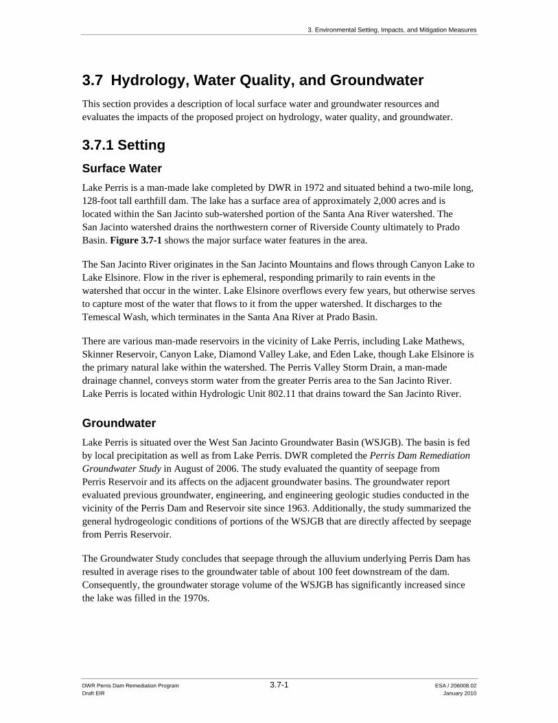
3.7.1 Setting Surface Water Lake Perris is a man-made lake completed by DWR in 1972 and situated behind a two-mile long, 128-foot tall earthfill dam. The lake has a surface area of approximately 2,000 acres and is located within the San Jacinto sub-watershed portion of the Santa Ana River watershed. The San Jacinto watershed drains the northwestern corner of Riverside County ultimately to Prado Basin. Figure 3.7-1 shows the major surface water features in the area.
The San Jacinto River originates in the San Jacinto Mountains and flows through Canyon Lake to Lake Elsinore. Flow in the river is ephemeral, responding primarily to rain events in the watershed that occur in the winter. Lake Elsinore overflows every few years, but otherwise serves to capture most of the water that flows to it from the upper watershed. It discharges to the Temescal Wash, which terminates in the Santa Ana River at Prado Basin.
There are various man-made reservoirs in the vicinity of Lake Perris, including Lake Mathews, Skinner Reservoir, Canyon Lake, Diamond Valley Lake, and Eden Lake, though Lake Elsinore is the primary natural lake within the watershed. The Perris Valley Storm Drain, a man-made drainage channel, conveys storm water from the greater Perris area to the San Jacinto River. Lake Perris is located within Hydrologic Unit 802.11 that drains toward the San Jacinto River.
Groundwater Lake Perris is situated over the West San Jacinto Groundwater Basin (WSJGB). The basin is fed by local precipitation as well as from Lake Perris. DWR completed the Perris Dam Remediation Groundwater Study in August of 2006. The study evaluated the quantity of seepage from Perris Reservoir and its affects on the adjacent groundwater basins. The groundwater report evaluated previous groundwater, engineering, and engineering geologic studies conducted in the vicinity of the Perris Dam and Reservoir site since 1963. Additionally, the study summarized the general hydrogeologic conditions of portions of the WSJGB that are directly affected by seepage from Perris Reservoir.
The Groundwater Study concludes that seepage through the alluvium underlying Perris Dam has resulted in average rises to the groundwater table of about 100 feet downstream of the dam. Consequently, the groundwater storage volume of the WSJGB has significantly increased since the lake was filled in the 1970s.
Santa Ana RiverSanta Ana River
0 5
Miles
Figure 3.7-1Regional Hydrology
SOURCE: Riverside County, 2007.
Temescal CreekTemescal Creek
Lee lake
Canyon Lake
Lake MathewsLake Mathews
Diamond Valley LakeLake Elsinore
Lake PerrisLake Perris
Canyon Lake
Lee lake
Diamond Valley LakeLake Elsinore
PROJECT LOCATION
San Jacinto R
ive
r
San Jacinto R
ive
r
Temescal Wash
Temescal Wash
Temescal CreekTemescal Creek
Perris Valley Storm DrainPerris Valley Storm Drain
DWR - Perris Dam Remediation Program . 206008.02
3. Environmental Setting, Impacts, and Mitigation Measures 3.7 Hydrology, Water Quality, and Groundwater
DWR Perris Dam Remediation Program 3.7-3 ESA / 206008.02 Draft EIR January 2010
Climate The climate of the San Jacinto watershed is Mediterranean with hot, dry summers and cooler, wetter winters. Average annual precipitation ranges from nine to 11 inches per year. Most of the precipitation occurs between November and March in the form of rain with variable amounts of snow in the higher elevations. The climatological cycle of the region results in high surface water flows in the spring and early summer, followed by low flows during the dry season.
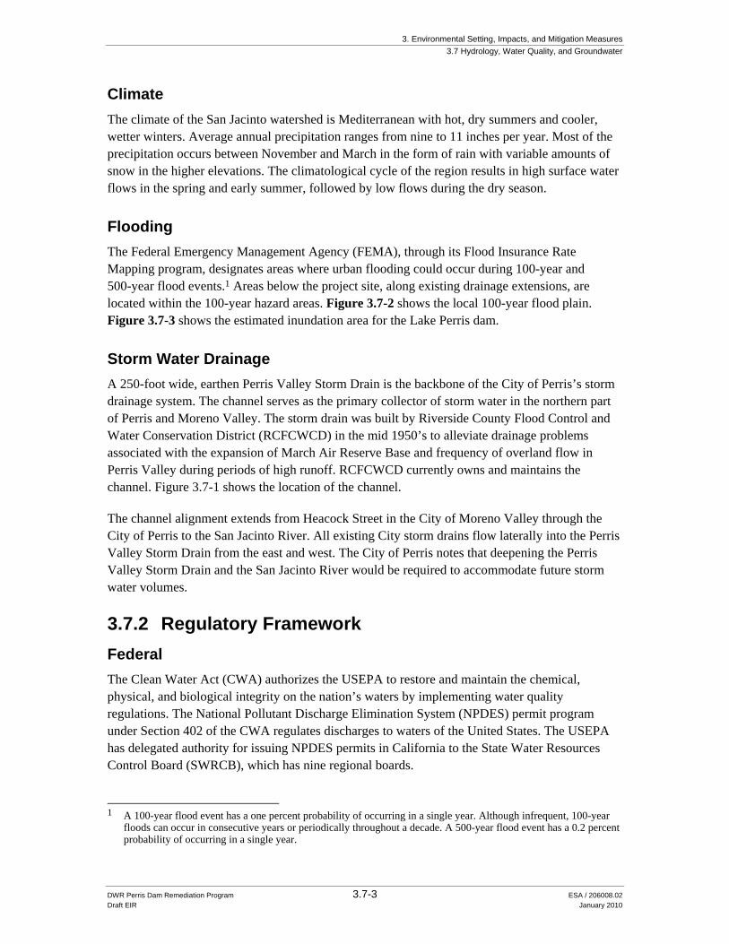
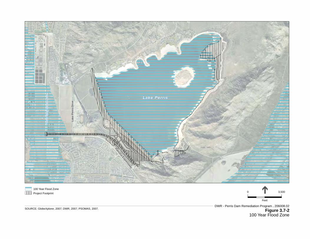
Flooding The Federal Emergency Management Agency (FEMA), through its Flood Insurance Rate Mapping program, designates areas where urban flooding could occur during 100-year and 500-year flood events.1 Areas below the project site, along existing drainage extensions, are located within the 100-year hazard areas. Figure 3.7-2 shows the local 100-year flood plain. Figure 3.7-3 shows the estimated inundation area for the Lake Perris dam.
Storm Water Drainage A 250-foot wide, earthen Perris Valley Storm Drain is the backbone of the City of Perris’s storm drainage system. The channel serves as the primary collector of storm water in the northern part of Perris and Moreno Valley. The storm drain was built by Riverside County Flood Control and Water Conservation District (RCFCWCD) in the mid 1950’s to alleviate drainage problems associated with the expansion of March Air Reserve Base and frequency of overland flow in Perris Valley during periods of high runoff. RCFCWCD currently owns and maintains the channel. Figure 3.7-1 shows the location of the channel.
The channel alignment extends from Heacock Street in the City of Moreno Valley through the City of Perris to the San Jacinto River. All existing City storm drains flow laterally into the Perris Valley Storm Drain from the east and west. The City of Perris notes that deepening the Perris Valley Storm Drain and the San Jacinto River would be required to accommodate future storm water volumes.
3.7.2 Regulatory Framework Federal The Clean Water Act (CWA) authorizes the USEPA to restore and maintain the chemical, physical, and biological integrity on the nation’s waters by implementing water quality regulations. The National Pollutant Discharge Elimination System (NPDES) permit program under Section 402 of the CWA regulates discharges to waters of the United States. The USEPA has delegated authority for issuing NPDES permits in California to the State Water Resources Control Board (SWRCB), which has nine regional boards.
1 A 100-year flood event has a one percent probability of occurring in a single year. Although infrequent, 100-year
floods can occur in consecutive years or periodically throughout a decade. A 500-year flood event has a 0.2 percent probability of occurring in a single year.
SOURCE: Riverside County, 2007.DWR - Perris Dam Remediation Program . 206008.02
3. Environmental Setting, Impacts, and Mitigation Measures 3.7 Hydrology, Water Quality, and Groundwater
DWR Perris Dam Remediation Program 3.7-6 ESA / 206008.02 Draft EIR January 2010
The Santa Ana RWQCB regulates water quality in the project area. The CWA requires states to establish water quality standards to protect designated uses for all waters of the United States.
The Federal Clean Water Act Section 303(d) requires that states identify waters that do not meet water quality standards (beneficial uses, water quality objectives and the antidegradation policy) with the implementation of technology-based controls. Once a water body has been placed on the 303(d) list of impaired waters, states are required to develop a Total Maximum Daily Load (TMDL) to address each pollutant causing impairment. As a surface water reservoir for drinking water, Lake Perris is not an impaired water body on the 303(d) list.
Executive Order 11988, Flood Plain Management Executive Order 11988 requires the Corps to provide leadership and to take action to:
• Avoid development in the existing 100-year floodplain, unless such development is the only practicable alternative;
• Reduce the hazards and risk associated with floods; • Minimize the impact of floods on human health, safety, and welfare; and • Restore and preserve the natural and beneficial values of the current floodplain.
To comply with Executive Order 11988, the policy of the Corps is to formulate projects that, to the extent possible, avoid or minimize adverse effects associated with use of the floodplain, and avoid inducing development in an existing floodplain unless there is no practicable alternative.
State The Porter-Cologne Water Quality Control Act mandates that the SWRCB adopt statewide water quality control plans, which serve as the legal, technical, and programmatic basis of water quality regulation for a region. The project area lies within the jurisdiction of the RWQCB, Santa Ana Region. The Santa Ana Region Basin Plan contains descriptions of beneficial uses of all surface and groundwater resources, water quality objectives, and strategies for achieving the water quality objectives, such as the adoption of TMDLs (RWQCB, 1995).
The Basin Plan identifies the following beneficial uses for Lake Perris:
• Municipal And Domestic Supply (MUN), • Agricultural Water Supply (AGR), • Industrial Service Supply (IND), • Industrial Process Supply (PROC), • Groundwater Recharge (GWR),
Local The NPDES permit system includes coverage of storm water runoff from construction sites greater than one acre in area. In the project area, the storm water program is administered by the Riverside County Department of Building and Safety, Grading Division. The Riverside County
3. Environmental Setting, Impacts, and Mitigation Measures 3.7 Hydrology, Water Quality, and Groundwater
DWR Perris Dam Remediation Program 3.7-7 ESA / 206008.02 Draft EIR January 2010
Department of Building and Safety Grading Division administers storm water quality management program for the Lake Perris area.
The federal CWA effectively prohibits discharges of storm water from construction projects unless the discharge is in compliance with an NPDES permit. The SWRCB has adopted a statewide General Permit for Stormwater Discharges Associated with Construction Activity that encompasses one or more acres of soil disturbance.
The NPDES storm water program requires operators of both large and small construction sites to obtain authorization to discharge storm water under an NPDES construction permit. Construction activity resulting in a land disturbance of one acre or more must obtain coverage under the General Permit. In general, the NPDES storm water permitting requirements for construction activities require that the landowner and/or contractor develop and implement a SWPPP and submit required notices. The SWPPP must specify BMPs that would prevent construction pollutants from running offsite into receiving waters. The SWPPP must include measures for erosion and sediment controls, methods for construction waste handling and disposal, and post-construction erosion and sediment control requirements. The SWPPP also addresses the elimination or reduction of non-storm water discharges to receiving waters and inspection procedures for BMPs.
Riverside County Flood Control and Water Conservation District The RCFCWCD has established Master Drainage Plans and Area Drainage Plans that guide the sizing of drainage infrastructure needed to provide the conveyance requirements of the County. These documents provide design conditions for development in the County.
3.7.3 Impacts and Mitigation Measures Significance Criteria For the purposes of this EIR and consistent with Appendix G of the CEQA Guidelines, a project would have a significant impact to hydrology, water quality, or groundwater if it would:
• Violate any water quality standards or waste discharge requirements; • Substantially deplete groundwater supplies or interfere substantially with groundwater
recharge; • Substantially alter the existing drainage patterns in a manner that would result in substantial
erosion or siltation on or off the site; • Create or contribute runoff water that would exceed the capacity of existing or planned
storm water drainage systems or provide substantial additional sources of polluted runoff; • Substantially degrade water quality; • Be subject to inundation by seiche, tsunami, or mudflow; • Place housing within a 100-year flood hazard area as mapped on a federal Flood Hazard
Boundary or Flood Insurance Rate Map or other flood hazard delineation map;
3. Environmental Setting, Impacts, and Mitigation Measures 3.7 Hydrology, Water Quality, and Groundwater
DWR Perris Dam Remediation Program 3.7-8 ESA / 206008.02 Draft EIR January 2010
• Place structures within a 100-year flood hazard area that would impede or redirect flood flows; or
• Contaminate a public water supply.
Surface Drainage The proposed project would not significantly alter the drainage patterns of the project areas that would result in substantial erosion potential. The new dam face would have a similar slope and would be constructed of similar material as the existing dam. The borrow area would be submerged into the lake following completion of the stability berm. The quarry would become deeper, but would not alter drainage patterns. The new outlet facility would not alter drainage patterns in the area. Neither emergency outlet extension alternative would disrupt local storm water runoff systems. The outlet extension would convey water to the Perris Valley Storm Drain which has adequate capacity to accommodate the emergency flow during otherwise dry conditions.
Flood Risk Seiche waves could occur in the lake resulting from a seismic event. The dam is designed to contain seiche waves that could be generated by local seismic activity. The strengthening of the dam would further reduce the risk of damage from a seiche wave caused by an earthquake. The project would not subject people to increased hazards from seiche waves. The site is too far from the coast to be affected by tsunami waves. The strengthening of the dam would not increase mudflow hazards.
No structures would be constructed within the 100-year flood plain. The project would reinforce the structural strength of the dam reducing the potential flood risk downstream of the dam. During construction activities, the water level behind the dam would be maintained at the lower level to reduce the potential hazard of seismic-related dam failure.
Water Quality Impact 3.7-1: Construction activities could promote soil erosion or result in chemical spills that could pollute storm water runoff and adversely affect local receiving water quality.
Construction would include site clearing, grading, excavation, blasting, soil stockpiling, backfilling, tunneling, and compacting. Project construction would occur within areas that drain to Lake Perris or to tributaries of the Perris Valley Storm Drain. Construction activities could promote soil erosion discharging sediment to adjacent drainages. Sedimentation would degrade the water quality of the receiving waters. Hazardous materials associated with construction equipment such as fuels, oils, antifreeze, coolants, and other substances would adversely affect water quality if inadvertently released to surface waters. Construction would involve substantial grading exposing large areas of soil to erosion during rain events. DWR would be required to prepare a SWPPP for coverage under the state-wide storm water discharge NPDES permit. Incorporation of BMPs would minimize the impact to a less than significant level.
3. Environmental Setting, Impacts, and Mitigation Measures 3.7 Hydrology, Water Quality, and Groundwater
DWR Perris Dam Remediation Program 3.7-9 ESA / 206008.02 Draft EIR January 2010
Specific BMPs that may be applicable would include establishment of sediment basins and erosion control perimeter around active construction and contractor layout areas, silt fencing, jute netting, fiber rolls, or other appropriate measures to control sediment from leaving the construction area. BMPs such as installing containment measures at fuel storage sites and avoiding overfilling of tanks would prevent chemicals from being transported off site. Construction contractors would be made aware of the required BMPs and good housekeeping measures for the project site and associated construction staging areas. Construction debris and waste materials would be collected at the end of each day and properly disposed in trash or recycle bins.
The haul road over the Bernasconi Hills would be subject to erosion once completed due to the slope over the hill. The existing runoff in the hills meanders through boulder fields or sheet flows down cliff faces to the lower elevations. Mitigation Measure 3.7-1b requires that the road be designed with adequate drainage features to reduce erosion potential.
Mitigation Measures
Mitigation Measure 3.7-1a: DWR shall prepare a SWPPP for each construction activity associated with the proposed project. The SWPPP shall be maintained at the construction site for the entire duration of construction. The objectives of the SWPPP are to identify pollutant sources that may affect the quality of storm water discharge and to implement BMPs to reduce pollutants in storm water discharges during construction and post construction. SWPPPs shall include the following:
• Source identification; • Preparation of a site map; • Description of construction materials, practices, and equipment storage and
maintenance; • List of pollutants likely to contact storm water; • Estimate of the construction site area and percent impervious area; • Erosion and sedimentation control practices, including soils stabilization,
revegetation, and runoff control to limit increases in sediment in storm water runoff, such as detention basins, fiber rolls, silt fences, check dams, geofabrics, drainage swales, and sandbag dikes;
• Proposed construction dewatering plans; • List of provisions to eliminate or reduce discharge of materials to storm water; • Description of waste management practices; • Spill prevention and control measures; • Maintenance and training practices; and • Sampling and analysis strategy and sampling schedule for discharges from
construction activities.
3. Environmental Setting, Impacts, and Mitigation Measures 3.7 Hydrology, Water Quality, and Groundwater
DWR Perris Dam Remediation Program 3.7-10 ESA / 206008.02 Draft EIR January 2010
Mitigation Measure 3.7-1b: DWR shall incorporate into contract specifications the requirements that:
• The construction staging areas shall be graded to contain surface runoff so that contaminants such as oil, grease, and fuel products do not drain towards receiving waters.
• If heavy-duty construction equipment is stored overnight at the construction staging areas, drip pans or plastic lines with edges shall be placed beneath the machinery engine block and hydraulic systems to prevent any leakage from entering runoff or receiving waters.
• No pesticides or herbacides shall be used to maintain vegetation clearing during construction.
• Vehicle fueling shall be conducted a minimum of 500 feet from Lake Perris.
• The haul road over the Bernasconi Hills shall be designed with a drainage system that prevents runoff scouring and rutting. Runoff from the sloping roadway shall be conveyed to drainages at lower elevations with minimal velocity to prevent scouring.
• Any grout waste or spills will be cleaned up immediately and disposed of off site.
• Spill kits capable of containing hazardous spills will be stored on-site. Required materials will be specified in contractor specifications.
Significance after Mitigation: Less than Significant.
Groundwater Recharge Impact 3.7-2: The dam remediation could interfere with groundwater recharge.
Lake Perris is known to significantly augment local groundwater quantity from seepage through the alluvial foundation material under the dam. The Perris Dam Remediation Groundwater Study showed that lowering the surface water elevation to 1563 feet amsl has resulted in a five to seven foot lowering of the groundwater elevation at monitoring wells located adjacent to the left and right abutments of the dam. The data show the direct connection between the lake and the local groundwater basin at these two well monitoring locations. The Groundwater Study also showed that other groundwater monitoring wells, some as far as ten miles away, remained fairly constant despite the lowering of the reservoir elevation. As noted in the Geology Section, the dam is underlain by alluvium typically ranging in thickness from zero to 150 feet throughout the reservoir and dam site area except for an area beneath the left reach of the dam where a deep paleo-channel occupies a topographic low in the granitic bedrock. The alluvium in this paleo-channel attains a thickness of as much as 290 feet below ground surface. The SWRCB has acknowledged the presence of an underground stream in this location that conveys native groundwater apparently not associated with Lake Perris through the valley. The proposed project would essentially introduce cement columns up to 40 feet deep beneath the base of the dam that would strengthen the foundation of the dam but would not prevent seepage that occurs under
3. Environmental Setting, Impacts, and Mitigation Measures 3.7 Hydrology, Water Quality, and Groundwater
DWR Perris Dam Remediation Program 3.7-11 ESA / 206008.02 Draft EIR January 2010
existing conditions. The intermittent columns would not impinge on the amount of water seepage from the dam or in any underground stream channel that may be present.
During construction, either temporary steel sheet piles or a permanent CDSM cut-off wall would be installed at the toe of the dam to a depth of up to 60 feet below ground surface. The barrier would be needed to dewater the excavation area during the CDSM process. If sheet piles are used, they would be removed once the CDSM columns were in place and the excavation re-filled. If a permanent CDSM cut-off wall is used to enable construction dewatering, it would be left in place. Although the permanent dewatering cut-off wall would create a shallow barrier to water seepage, it would not be deep enough to significantly disrupt the current seepage. The seepage would not be affected by the remediation project since the alluvial soils reach typical depths of 150 feet below ground surface. The proposed dewatering system would function similar to the existing system, lowering groundwater levels near the toe of the dam, but not affecting groundwater levels farther south in the valley. Therefore, downstream groundwater producers would not be affected by the project.
Significance: Less than Significant.
Runoff Capacity
Impact 3.7-3: The emergency outlet extension could exceed the capacity of the Perris Valley Storm Drain during a rain event.
The emergency outlet extension would channel water to the Perris Valley Storm Drain that flows to the San Jacinto River and Lake Elsinore. The Perris Valley Storm Drain is a storm water runoff facility that drains an upper portion of the San Jacinto watershed. The emergency outlet extension provides emergency drawdown capabilities, and is not intended for use as a storm drain system. Both the aboveground and underground alternatives for the emergency outlet extension would be approximately two miles long with a 1500 cfs capacity. During heavy rain events, the Perris Valley Storm Drain may not have the additional capacity needed to accommodate the full volume from the emergency outlet extension in addition to the storm run off. The duration of high flow in the Perris Valley Storm Drain is generally limited to periods of rain, with the flow reducing sharply as storms pass. The emergency outlet extension is not intended for routine use. Management of the drawdown to avoid exceeding the storm drain system in coordination with the RCFCWCD would ensure that the system capacity is not exceeded.
Significance: Less than Significant.
3. Environmental Setting, Impacts, and Mitigation Measures 3.7 Hydrology, Water Quality, and Groundwater
DWR Perris Dam Remediation Program 3.7-12 ESA / 206008.02 Draft EIR January 2010
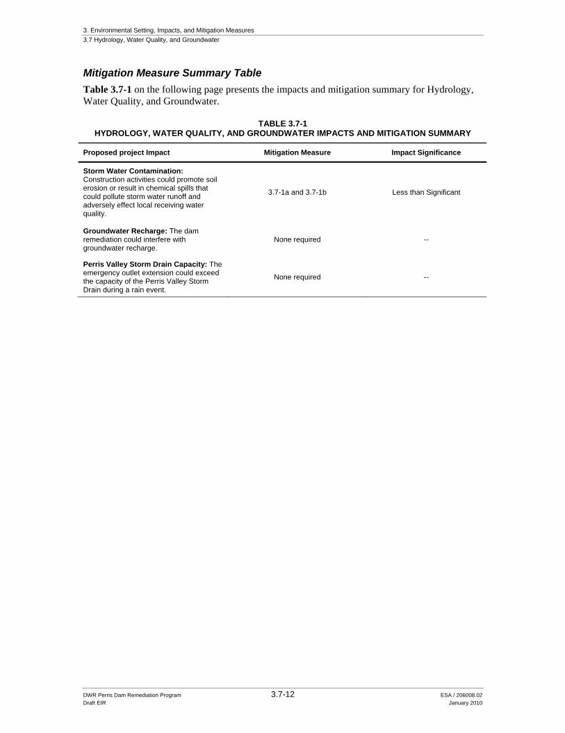
Mitigation Measure Summary Table Table 3.7-1 on the following page presents the impacts and mitigation summary for Hydrology, Water Quality, and Groundwater.
TABLE 3.7-1 HYDROLOGY, WATER QUALITY, AND GROUNDWATER IMPACTS AND MITIGATION SUMMARY
Storm Water Contamination: Construction activities could promote soil erosion or result in chemical spills that could pollute storm water runoff and adversely effect local receiving water quality.
3.7-1a and 3.7-1b Less than Significant
Groundwater Recharge: The dam remediation could interfere with groundwater recharge.
None required --
Perris Valley Storm Drain Capacity: The emergency outlet extension could exceed the capacity of the Perris Valley Storm Drain during a rain event.


![[hydrology] groundwater hydrology - david k. todd (2005).pdf](https://static.documents.pub/doc/80x56/577c77961a28abe0548cb0b1/hydrology-groundwater-hydrology-david-k-todd-2005pdf.jpg)


