3D BUILDING MODELING IN LOD2 USING THE CITYGML STANDARD Dimitra Preka, Anastasios Doulamis School of Rural and Surveying Engineering, National Technical University of Athens, 9 Iroon Polytechneiou str, 15780 Zografou, Greece - [email protected], [email protected]11 th 3D Geoinfo Conference KEY WORDS: CityGML, 3D Modeling, Buildings, LoD2, Database, PostgreSQL, 3DCityDB, SketchUp ABSTRACT: Over the last decade, scientific research has been increasingly focused on the third dimension in all fields and especially in sciences related to geographic information, the visualization of natural phenomena and the visualization of the complex urban reality. The field of 3D visualization has achieved rapid development and dynamic progress, especially in urban applications, while the technical restrictions on the use of 3D information tend to subside due to advancements in technology. A variety of 3D modeling techniques and standards has already been developed, as they gain more traction in a wide range of applications. Such a modern standard is the CityGML, which is open and allows for sharing and exchanging of 3D city models. Within the scope of this study, key issues for the 3D modeling of spatial objects and cities are considered and specifically the key elements and abilities of CityGML standard, which is used in order to produce a 3D model of 14 buildings that constitute a block at the municipality of Kaisariani, Athens, in Level of Detail 2 (LoD2), as well as the corresponding relational database. The proposed tool is based upon the 3DCityDB package in tandem with a geospatial database (PostgreSQL w/ PostGIS 2.0 extension). The latter allows for execution of complex queries regarding the spatial distribution of data. The system is implemented in order to facilitate a real-life scenario in a suburb of Athens. 1. INTRODUCTION In recent years, 3D modeling of spatial objects and entire cities has become more and more necessary to a wide range of applications, such as those related to urban planning, 3D Cadastre and Smart Cities. Said applications are increasingly used by a number of cities and rural areas. This is a complex process, which comprises an approach of visualization of heterogeneous data, such as digital vector drawings, 2D and 3D virtual data, measurements, and combined use of different software programs. In recent decades, in the construction field particularly, the need to share and exchange of information led to the development of technology and applications, such as Building Information Modeling (BIM) and 3D models of geospatial information (El- Mekawy, 2010). These models define spatial objects with geometric and semantic representations. Industry Foundation Classes (IFC) and City Geography Markup Language (CityGML) are the best known semantic standards that are used by these 3D spatial models of the real world (El-Mekawy, 2010). Nowadays, increasingly detailed 3D models are the cornerstone of many industries, like cadastral applications, construction, architecture, film and video games (Góźdź, Pachelski, Van Oosterom, Coors, 2014). This demand is met by an increasing number software programs, proprietary and otherwise, that enable the application of 3D modeling techniques. 1.1 3D City Modeling Nowadays, a rapidly increasing number of companies create virtual 3D city models for use in various markets, such as urban planning, telecommunications, disaster/crisis management, 3D Cadastre, tourism, navigation, facilities management, environmental simulations and Smart Cities applications (Gröger, Kolbe, Czerwinski, Nagel, 2008). 3D city models are digital representations of the Earth's surface and the spatial objects that compose a city. In such models, the representation and the relationship between spatial objects should be clear and modeled (Stadler, Kolbe, 2007). Most efforts to model 3D cities focus on the representation of geometrical models while disregarding the models’ semantic and topological parts. As a consequence, these parts cannot be used in GIS applications in which spatial queries, analysis tasks and exportation of spatial data are implemented, and are deprived of interoperability between different software packages and users. Given that the limited capability of models’ reuse confines the wider use of 3D city models, a different approach to modeling had to be created for the purpose of covering the informative needs of many fields of study (Gröger, Kolbe, Czerwinski, Nagel, 2008). In order for information from various applications to be reused, common standards should apply. In this regard, the CityGML model has been developed as a geospatial standard that comprises a semantic data model and an open standard. Consequently, it is suitable for all instances where urban objects can be represented and connected with various spatial relationships (Zhu, Li, Zhang, 2005). Information modeling was originally created in the mid-1980s. The environment was greatly affected by the lack of communication between the various users and this had a negative impact on the efficiency and function of the industry. Research and Development (R&D) in this field has resulted in the development of BIM, in order to boost the construction area (El- Mekawy, 2010). BIM is a system that allows for 3D representation of construction and is a technological method where all relevant information, geometric and semantic, is contained in a 3D digital model. Reference standards exist since 1988. R&D advancements resulted in the incorporation of the IFC standard in BIM applications, starting in 1996 (IAI, 1999). The IFC standard is not just about structural components’ modeling, as it also represents various advanced procedures and analyses based on the spatial relationships between these components. The International Archives of the Photogrammetry, Remote Sensing and Spatial Information Sciences, Volume XLII-2/W2, 2016 11th 3D Geoinfo Conference, 20–21 October 2016, Athens, Greece This contribution has been peer-reviewed. doi:10.5194/isprs-archives-XLII-2-W2-11-2016 11
Transcript
3D BUILDING MODELING IN LOD2 USING THE CITYGML STANDARD
Dimitra Preka, Anastasios Doulamis
School of Rural and Surveying Engineering, National Technical University of Athens,
Over the last decade, scientific research has been increasingly focused on the third dimension in all fields and especially in sciences related to geographic information, the visualization of natural phenomena and the visualization of the complex urban reality. The field
of 3D visualization has achieved rapid development and dynamic progress, especially in urban applications, while the technical
restrictions on the use of 3D information tend to subside due to advancements in technology. A variety of 3D modeling techniques and
standards has already been developed, as they gain more traction in a wide range of applications. Such a modern standard is the CityGML, which is open and allows for sharing and exchanging of 3D city models. Within the scope of this study, key issues for the
3D modeling of spatial objects and cities are considered and specifically the key elements and abilities of CityGML standard, which
is used in order to produce a 3D model of 14 buildings that constitute a block at the municipality of Kaisariani, Athens, in Level of
Detail 2 (LoD2), as well as the corresponding relational database. The proposed tool is based upon the 3DCityDB package in tandem with a geospatial database (PostgreSQL w/ PostGIS 2.0 extension). The latter allows for execution of complex queries regarding the
spatial distribution of data. The system is implemented in order to facilitate a real-life scenario in a suburb of Athens.
1. INTRODUCTION
In recent years, 3D modeling of spatial objects and entire cities
has become more and more necessary to a wide range of
applications, such as those related to urban planning, 3D Cadastre and Smart Cities. Said applications are increasingly used by a
number of cities and rural areas. This is a complex process, which
comprises an approach of visualization of heterogeneous data,
such as digital vector drawings, 2D and 3D virtual data, measurements, and combined use of different software programs.
In recent decades, in the construction field particularly, the need
to share and exchange of information led to the development of
technology and applications, such as Building Information Modeling (BIM) and 3D models of geospatial information (El-
Mekawy, 2010). These models define spatial objects with
geometric and semantic representations. Industry Foundation
Classes (IFC) and City Geography Markup Language (CityGML) are the best known semantic standards that are used
by these 3D spatial models of the real world (El-Mekawy, 2010).
Nowadays, increasingly detailed 3D models are the cornerstone
of many industries, like cadastral applications, construction,
architecture, film and video games (Góźdź, Pachelski, Van
Oosterom, Coors, 2014). This demand is met by an increasing
number software programs, proprietary and otherwise, that enable the application of 3D modeling techniques.
1.1 3D City Modeling
Nowadays, a rapidly increasing number of companies create virtual 3D city models for use in various markets, such as urban
planning, telecommunications, disaster/crisis management, 3D
(Gröger, Kolbe, Czerwinski, Nagel, 2008). 3D city models are
digital representations of the Earth's surface and the spatial
objects that compose a city. In such models, the representation and the relationship between spatial objects should be clear and
modeled (Stadler, Kolbe, 2007). Most efforts to model 3D cities
focus on the representation of geometrical models while
disregarding the models’ semantic and topological parts. As a
consequence, these parts cannot be used in GIS applications in which spatial queries, analysis tasks and exportation of spatial
data are implemented, and are deprived of interoperability
between different software packages and users. Given that the
limited capability of models’ reuse confines the wider use of 3D city models, a different approach to modeling had to be created
for the purpose of covering the informative needs of many fields
of study (Gröger, Kolbe, Czerwinski, Nagel, 2008).
In order for information from various applications to be reused,
common standards should apply. In this regard, the CityGML
model has been developed as a geospatial standard that comprises
a semantic data model and an open standard. Consequently, it is suitable for all instances where urban objects can be represented
and connected with various spatial relationships (Zhu, Li, Zhang,
2005).
Information modeling was originally created in the mid-1980s.
The environment was greatly affected by the lack of
communication between the various users and this had a negative
impact on the efficiency and function of the industry. Research and Development (R&D) in this field has resulted in the
development of BIM, in order to boost the construction area (El-
Mekawy, 2010). BIM is a system that allows for 3D
representation of construction and is a technological method where all relevant information, geometric and semantic, is
contained in a 3D digital model.
Reference standards exist since 1988. R&D advancements
resulted in the incorporation of the IFC standard in BIM
applications, starting in 1996 (IAI, 1999). The IFC standard is not
just about structural components’ modeling, as it also represents various advanced procedures and analyses based on the spatial
relationships between these components.
The International Archives of the Photogrammetry, Remote Sensing and Spatial Information Sciences, Volume XLII-2/W2, 2016 11th 3D Geoinfo Conference, 20–21 October 2016, Athens, Greece
This contribution has been peer-reviewed. doi:10.5194/isprs-archives-XLII-2-W2-11-2016
BIM and 3D models of geospatial information are currently
considered a means for determining spatial objects with
geometric and semantic representations. In a similar fashion, IFC
and CityGML are the two best known semantic standards for the representation of designs and objects of the real world.
1.2 Previous Works on CityGML
For the storage and exchange of virtual 3D models of cities and
landscapes the CityGML standard is used (Gröger, Kolbe,
Czerwinski, Nagel, 2008) and (Kolbe, König, Nagel, Stadler,
2009). As well known, the standard is based on the Geography
Markup Language 3 (GML3) schema (XML format) issued by the ISO TC211 and the Open Geospatial Consortium (OGC)
(Gröger, Kolbe, Czerwinski, Nagel, 2008). CityGML includes
generalization hierarchies between thematic classes,
aggregations, relations between spatial objects and spatial properties and covers the geometrical, topological, semantic and
appearance aspects of 3D city models. In addition, it
differentiates between five consecutive Levels of Detail (LoD)
(Gröger, Kolbe, Czerwinski, Nagel, 2008).
1.3 Contribution
The main goal of this paper is to develop an interoperable system
able to properly depict, manage and handle complex 3D cadastre information of residential houses. The tool is built around the
3DCityDB package in relation with a geospatial database,
PostgreSQL with the PostGIS extension (Kunde, Asche, Kolbe,
Nagel, Herreruela, König, 2013). The latter allows for data
organization and the implementation of complex queries
regarding the topological relationships between features. This
study is a first attempt at the implementation of an application
capable of facilitating engineers who operate within the land management, registry and other relevant fields, offering
appropriate data organization plus an easy and familiar interface.
The solution was tested and proven in a real-life application in
the suburb of Kaisariani, Athens.
2. METHODOLOGY
2.1 Data and Software
The main object of this research is the study and application of a technique of 3D modeling and visualization in LoD2 of a block
of 14 buildings using the CityGML standard. The study area is
located in Kaisariani, a municipality of Athens. For this study,
three software packages were used: SketchUp, PosgtreSQL/PostGIS and 3D City Database (3DCityDB).
2.2 Procedures
Collected data, for the buildings of the study area, consists of their address, use, roof type, height and number of storeys and
are to be recorded in a relational database.
The exterior of the buildings of the study area was designed in LoD2, in which the buildings’ surfaces are divided into ground,
wall and roof within SketchUp, by applying textures to the
buildings’ surfaces. As known in SketchUp, it is possible to
define a georeference by importing in the designing environment of the program an appropriate background image from Google
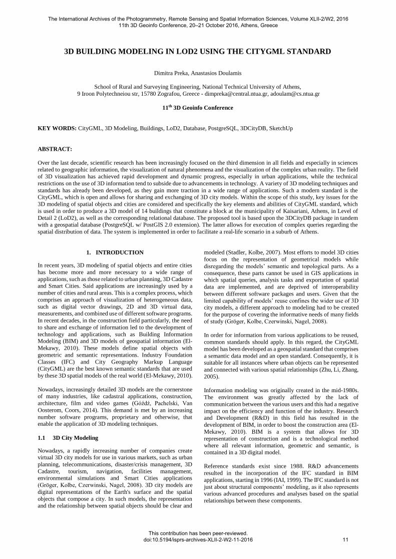
Earth (see Figure 1).
Figure 1. 3D Design of the Buildings in SketchUp
A CityGML file in GML3 schema of the 3D design followed by
a folder with images of the used textures were exported by
SketchUp too through the free plug-in, CityGML Editor 18 (see
Figure 2). The information about the geometry and all spatial
relations was derived by a 3D design of the buildings in .dxf format, provided by our Laboratory.
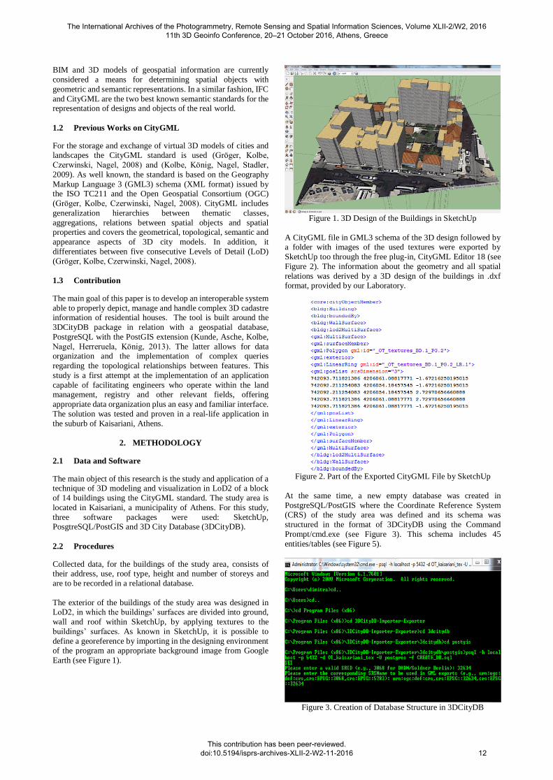
Figure 2. Part of the Exported CityGML File by SketchUp
At the same time, a new empty database was created in
PostgreSQL/PostGIS where the Coordinate Reference System (CRS) of the study area was defined and its schema was
structured in the format of 3DCityDB using the Command
Prompt/cmd.exe (see Figure 3). This schema includes 45
entities/tables (see Figure 5).
Figure 3. Creation of Database Structure in 3DCityDB
The International Archives of the Photogrammetry, Remote Sensing and Spatial Information Sciences, Volume XLII-2/W2, 2016 11th 3D Geoinfo Conference, 20–21 October 2016, Athens, Greece
This contribution has been peer-reviewed. doi:10.5194/isprs-archives-XLII-2-W2-11-2016
12
Subsequently, the empty database was populated automatically,
but fine-tuned manually, with the aforementioned data types,
within the 3DCityDB package and via the exported CityGML file from the first design step.
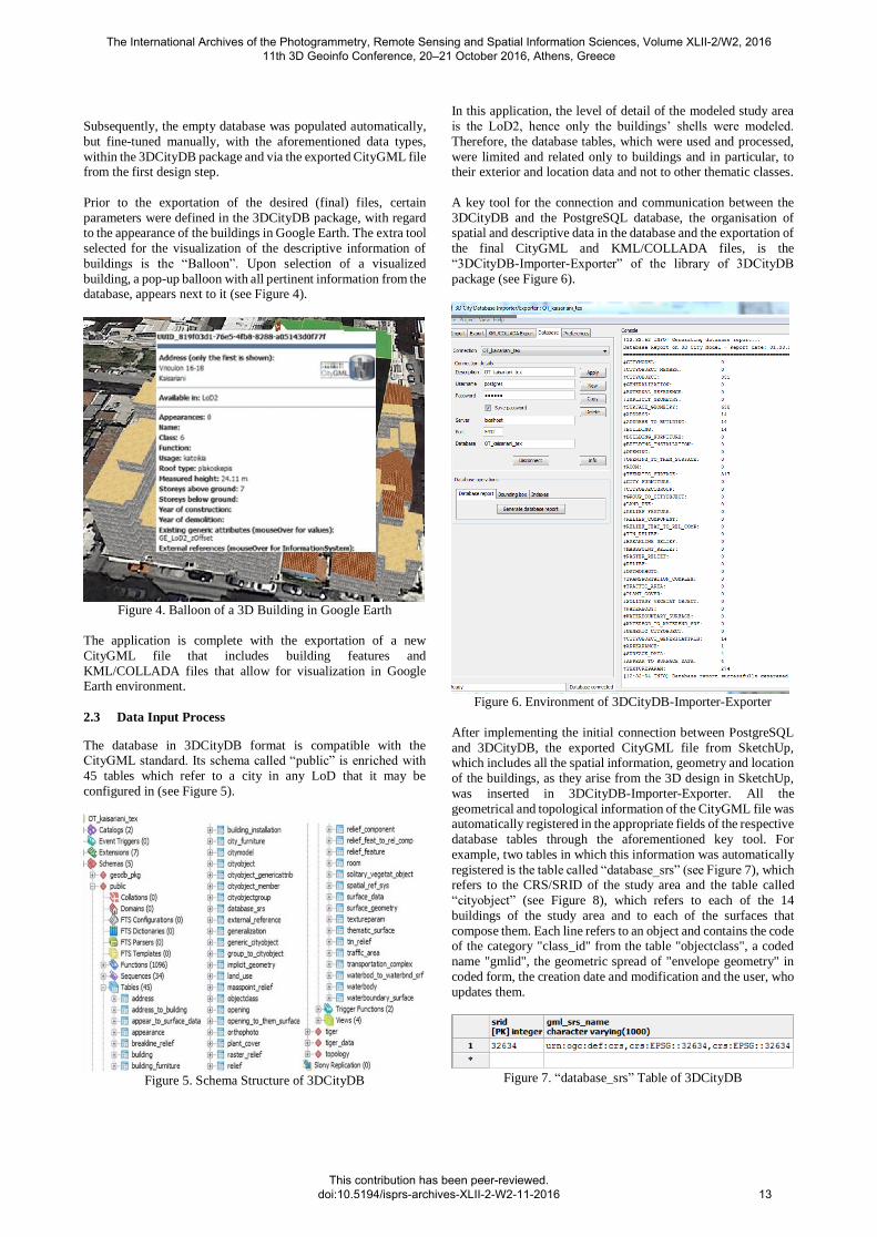
Prior to the exportation of the desired (final) files, certain
parameters were defined in the 3DCityDB package, with regard
to the appearance of the buildings in Google Earth. The extra tool
selected for the visualization of the descriptive information of
buildings is the “Balloon”. Upon selection of a visualized
building, a pop-up balloon with all pertinent information from the database, appears next to it (see Figure 4).
Figure 4. Balloon of a 3D Building in Google Earth
The application is complete with the exportation of a new
CityGML file that includes building features and
KML/COLLADA files that allow for visualization in Google Earth environment.
2.3 Data Input Process
The database in 3DCityDB format is compatible with the CityGML standard. Its schema called “public” is enriched with
45 tables which refer to a city in any LoD that it may be
configured in (see Figure 5).
Figure 5. Schema Structure of 3DCityDB
In this application, the level of detail of the modeled study area
is the LoD2, hence only the buildings’ shells were modeled.
Therefore, the database tables, which were used and processed,
were limited and related only to buildings and in particular, to their exterior and location data and not to other thematic classes.
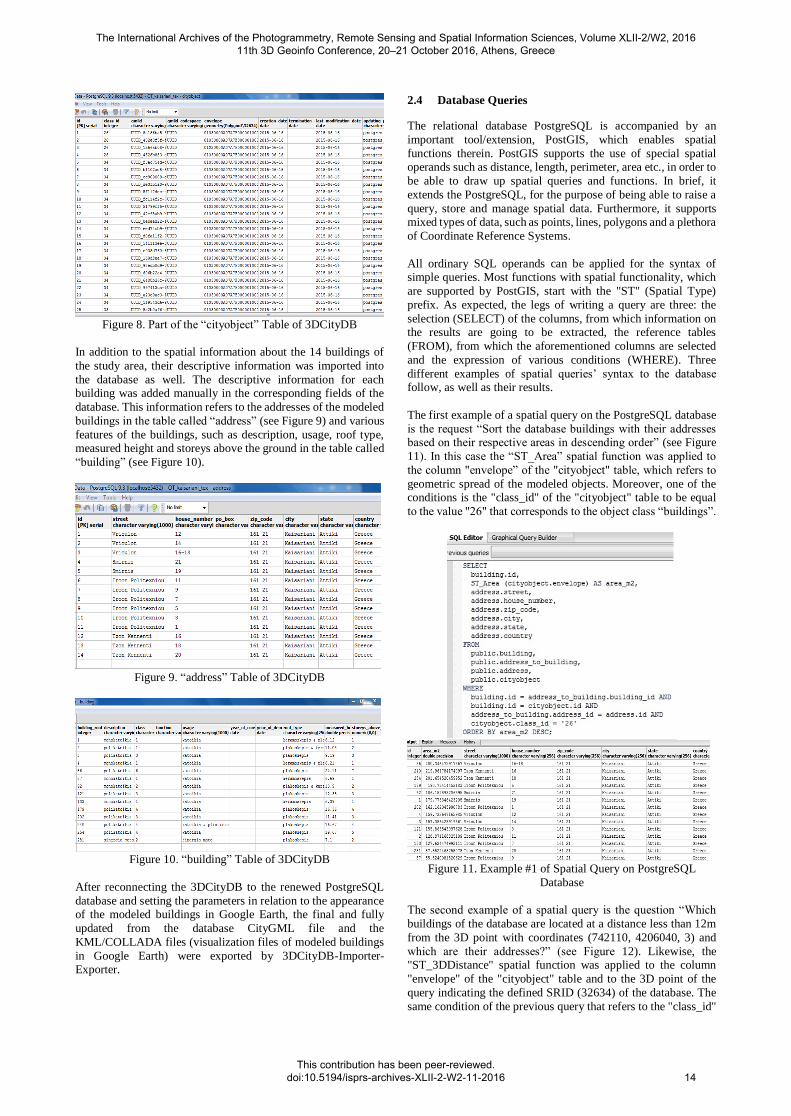
A key tool for the connection and communication between the
3DCityDB and the PostgreSQL database, the organisation of
spatial and descriptive data in the database and the exportation of
the final CityGML and KML/COLLADA files, is the
“3DCityDB-Importer-Exporter” of the library of 3DCityDB
package (see Figure 6).
Figure 6. Environment of 3DCityDB-Importer-Exporter
After implementing the initial connection between PostgreSQL
and 3DCityDB, the exported CityGML file from SketchUp, which includes all the spatial information, geometry and location
of the buildings, as they arise from the 3D design in SketchUp,
was inserted in 3DCityDB-Importer-Exporter. All the
geometrical and topological information of the CityGML file was automatically registered in the appropriate fields of the respective
database tables through the aforementioned key tool. For
example, two tables in which this information was automatically
registered is the table called “database_srs” (see Figure 7), which refers to the CRS/SRID of the study area and the table called
“cityobject” (see Figure 8), which refers to each of the 14
buildings of the study area and to each of the surfaces that
compose them. Each line refers to an object and contains the code of the category "class_id" from the table "objectclass", a coded
name "gmlid", the geometric spread of "envelope geometry" in
coded form, the creation date and modification and the user, who
updates them.
Figure 7. “database_srs” Table of 3DCityDB
The International Archives of the Photogrammetry, Remote Sensing and Spatial Information Sciences, Volume XLII-2/W2, 2016 11th 3D Geoinfo Conference, 20–21 October 2016, Athens, Greece
This contribution has been peer-reviewed. doi:10.5194/isprs-archives-XLII-2-W2-11-2016
13
Figure 8. Part of the “cityobject” Table of 3DCityDB
In addition to the spatial information about the 14 buildings of
the study area, their descriptive information was imported into
the database as well. The descriptive information for each building was added manually in the corresponding fields of the
database. This information refers to the addresses of the modeled
buildings in the table called “address” (see Figure 9) and various
features of the buildings, such as description, usage, roof type, measured height and storeys above the ground in the table called
“building” (see Figure 10).
Figure 9. “address” Table of 3DCityDB
Figure 10. “building” Table of 3DCityDB
After reconnecting the 3DCityDB to the renewed PostgreSQL
database and setting the parameters in relation to the appearance of the modeled buildings in Google Earth, the final and fully
updated from the database CityGML file and the
KML/COLLADA files (visualization files of modeled buildings
in Google Earth) were exported by 3DCityDB-Importer-Exporter.
2.4 Database Queries
The relational database PostgreSQL is accompanied by an
important tool/extension, PostGIS, which enables spatial
functions therein. PostGIS supports the use of special spatial operands such as distance, length, perimeter, area etc., in order to
be able to draw up spatial queries and functions. In brief, it
extends the PostgreSQL, for the purpose of being able to raise a
query, store and manage spatial data. Furthermore, it supports
mixed types of data, such as points, lines, polygons and a plethora
of Coordinate Reference Systems.
All ordinary SQL operands can be applied for the syntax of simple queries. Most functions with spatial functionality, which
are supported by PostGIS, start with the "ST" (Spatial Type)
prefix. As expected, the legs of writing a query are three: the
selection (SELECT) of the columns, from which information on the results are going to be extracted, the reference tables
(FROM), from which the aforementioned columns are selected
and the expression of various conditions (WHERE). Three
different examples of spatial queries’ syntax to the database follow, as well as their results.
The first example of a spatial query on the PostgreSQL database
is the request “Sort the database buildings with their addresses based on their respective areas in descending order” (see Figure
11). In this case the “ST_Area” spatial function was applied to
the column "envelope” of the "cityobject" table, which refers to
geometric spread of the modeled objects. Moreover, one of the
conditions is the "class_id" of the "cityobject" table to be equal
to the value "26" that corresponds to the object class “buildings”.
Figure 11. Example #1 of Spatial Query on PostgreSQL
Database
The second example of a spatial query is the question “Which
buildings of the database are located at a distance less than 12m
from the 3D point with coordinates (742110, 4206040, 3) and
which are their addresses?” (see Figure 12). Likewise, the "ST_3DDistance" spatial function was applied to the column
"envelope" of the "cityobject" table and to the 3D point of the
query indicating the defined SRID (32634) of the database. The
same condition of the previous query that refers to the "class_id"
The International Archives of the Photogrammetry, Remote Sensing and Spatial Information Sciences, Volume XLII-2/W2, 2016 11th 3D Geoinfo Conference, 20–21 October 2016, Athens, Greece
This contribution has been peer-reviewed. doi:10.5194/isprs-archives-XLII-2-W2-11-2016
14
of the "cityobject" table to be equal to the value "26", was applied
to this query as well.
Figure 12. Example #2 of Spatial Query on PostgreSQL
Database
The last example of a spatial query is the question “Which buildings of the database are overlapped with the framework with
coordinates (742110, 4206040) on its northwest end and
coordinates (742150, 4206061) on its southeast end and which
are their addresses?” (see Figure 13). In this example, the function "BOX3D" was applied in addition to the condition that
requires the "class_id" of the "cityobject" table to be equal to the
value "26".
Figure 13. Example #3 of Spatial Query on PostgreSQL
Database
3. RESULTS
As mentioned, the final product of this study consists of a
CityGML file and KML/COLLADA files. The CityGML file is
enriched with information regarding the buildings by the
relational database (see Figure 14).
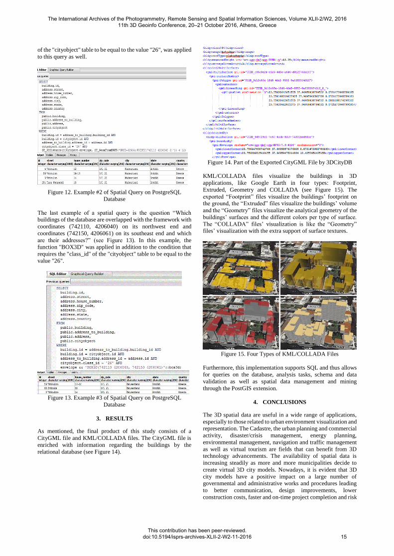
Figure 14. Part of the Exported CityGML File by 3DCityDB
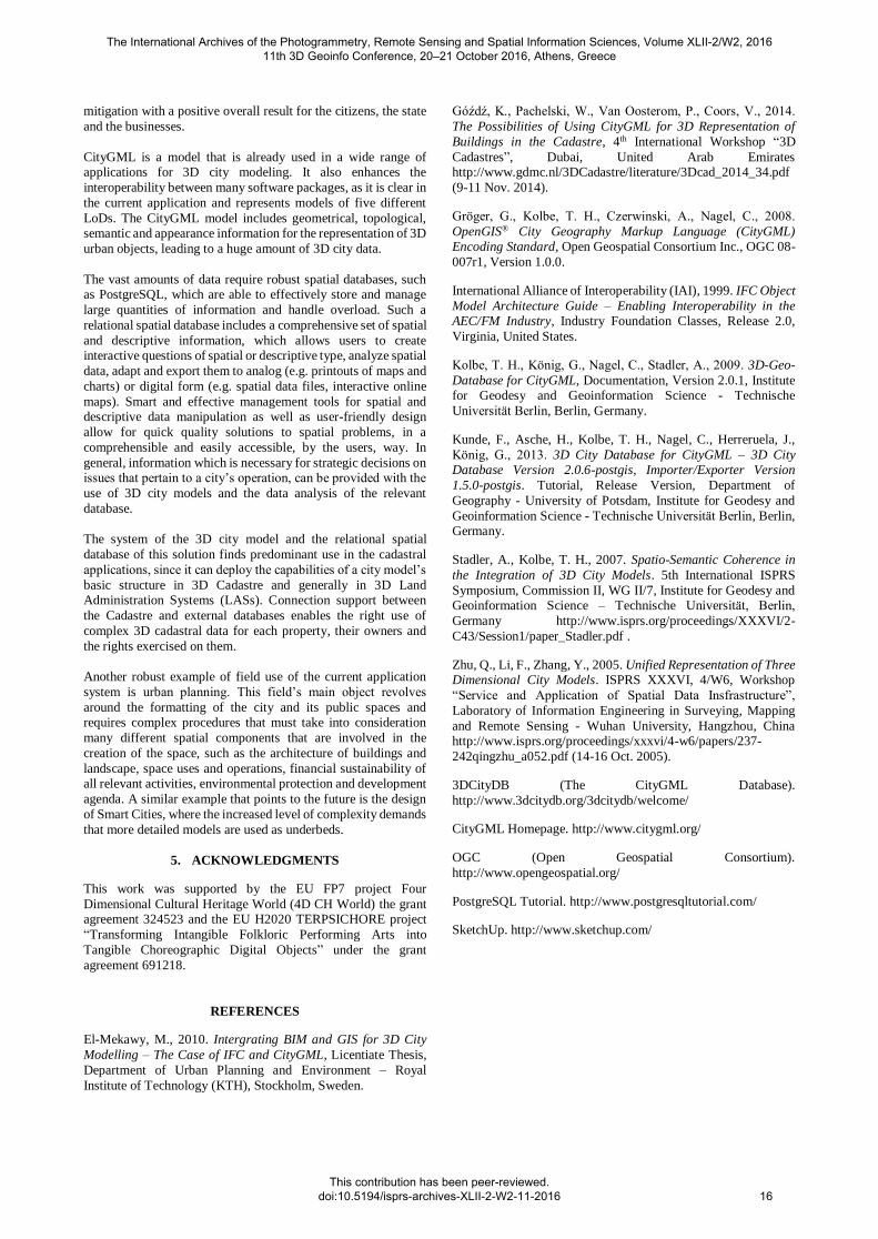
KML/COLLADA files visualize the buildings in 3D
applications, like Google Earth in four types: Footprint,
Extruded, Geometry and COLLADA (see Figure 15). The
exported “Footprint” files visualize the buildings’ footprint on the ground, the “Extruded” files visualize the buildings’ volume
and the “Geometry” files visualize the analytical geometry of the
buildings’ surfaces and the different colors per type of surface.
The “COLLADA” files’ visualization is like the “Geometry” files’ visualization with the extra support of surface textures.
Figure 15. Four Types of KML/COLLADA Files
Furthermore, this implementation supports SQL and thus allows
for queries on the database, analysis tasks, schema and data
validation as well as spatial data management and mining
through the PostGIS extension.
4. CONCLUSIONS
The 3D spatial data are useful in a wide range of applications,
especially to those related to urban environment visualization and representation. The Cadastre, the urban planning and commercial
activity, disaster/crisis management, energy planning,
environmental management, navigation and traffic management
as well as virtual tourism are fields that can benefit from 3D technology advancements. The availability of spatial data is
increasing steadily as more and more municipalities decide to
create virtual 3D city models. Nowadays, it is evident that 3D
city models have a positive impact on a large number of governmental and administrative works and procedures leading
to better communication, design improvements, lower
construction costs, faster and on-time project completion and risk
The International Archives of the Photogrammetry, Remote Sensing and Spatial Information Sciences, Volume XLII-2/W2, 2016 11th 3D Geoinfo Conference, 20–21 October 2016, Athens, Greece
This contribution has been peer-reviewed. doi:10.5194/isprs-archives-XLII-2-W2-11-2016
15
mitigation with a positive overall result for the citizens, the state
and the businesses.
CityGML is a model that is already used in a wide range of applications for 3D city modeling. It also enhances the
interoperability between many software packages, as it is clear in
the current application and represents models of five different
LoDs. The CityGML model includes geometrical, topological,
semantic and appearance information for the representation of 3D
urban objects, leading to a huge amount of 3D city data.
The vast amounts of data require robust spatial databases, such as PostgreSQL, which are able to effectively store and manage
large quantities of information and handle overload. Such a
relational spatial database includes a comprehensive set of spatial
and descriptive information, which allows users to create interactive questions of spatial or descriptive type, analyze spatial
data, adapt and export them to analog (e.g. printouts of maps and
charts) or digital form (e.g. spatial data files, interactive online
maps). Smart and effective management tools for spatial and descriptive data manipulation as well as user-friendly design
allow for quick quality solutions to spatial problems, in a
comprehensible and easily accessible, by the users, way. In
general, information which is necessary for strategic decisions on issues that pertain to a city’s operation, can be provided with the
use of 3D city models and the data analysis of the relevant
database.
The system of the 3D city model and the relational spatial
database of this solution finds predominant use in the cadastral
applications, since it can deploy the capabilities of a city model’s
basic structure in 3D Cadastre and generally in 3D Land Administration Systems (LASs). Connection support between
the Cadastre and external databases enables the right use of
complex 3D cadastral data for each property, their owners and
the rights exercised on them.
Another robust example of field use of the current application
system is urban planning. This field’s main object revolves
around the formatting of the city and its public spaces and requires complex procedures that must take into consideration
many different spatial components that are involved in the
creation of the space, such as the architecture of buildings and
landscape, space uses and operations, financial sustainability of all relevant activities, environmental protection and development
agenda. A similar example that points to the future is the design
of Smart Cities, where the increased level of complexity demands
that more detailed models are used as underbeds.
5. ACKNOWLEDGMENTS
This work was supported by the EU FP7 project Four
Dimensional Cultural Heritage World (4D CH World) the grant agreement 324523 and the EU H2020 TERPSICHORE project
“Transforming Intangible Folkloric Performing Arts into
Tangible Choreographic Digital Objects” under the grant
agreement 691218.
REFERENCES
El-Mekawy, M., 2010. Intergrating BIM and GIS for 3D City
Modelling – The Case of IFC and CityGML, Licentiate Thesis,
Department of Urban Planning and Environment – Royal
Institute of Technology (KTH), Stockholm, Sweden.
Góźdź, K., Pachelski, W., Van Oosterom, P., Coors, V., 2014.
The Possibilities of Using CityGML for 3D Representation of
Buildings in the Cadastre, 4th International Workshop “3D
Cadastres”, Dubai, United Arab Emirates http://www.gdmc.nl/3DCadastre/literature/3Dcad_2014_34.pdf
(9-11 Nov. 2014).
Gröger, G., Kolbe, T. H., Czerwinski, A., Nagel, C., 2008.
OpenGIS® City Geography Markup Language (CityGML) Encoding Standard, Open Geospatial Consortium Inc., OGC 08-
007r1, Version 1.0.0.
International Alliance of Interoperability (IAI), 1999. IFC Object
Model Architecture Guide – Enabling Interoperability in the AEC/FM Industry, Industry Foundation Classes, Release 2.0,
Virginia, United States.
Kolbe, T. H., König, G., Nagel, C., Stadler, A., 2009. 3D-Geo-
Database for CityGML, Documentation, Version 2.0.1, Institute
for Geodesy and Geoinformation Science - Technische
The International Archives of the Photogrammetry, Remote Sensing and Spatial Information Sciences, Volume XLII-2/W2, 2016 11th 3D Geoinfo Conference, 20–21 October 2016, Athens, Greece
This contribution has been peer-reviewed. doi:10.5194/isprs-archives-XLII-2-W2-11-2016