37
Università della Svizzera italiana Accademia di architettura 3D survey of the rivellino of Locarno Castle FINAL REPORT september 2007

UniversitàdellaSvizzeraitaliana
Accademiadi architettura
3D survey of the rivellino of Locarno CastleFINAL REPORTseptember 2007

2/37
Impressum
Editor:Institute for the Contemporary Urban Project (i.CUP), Accademia di Architettura di Mendrisio (AAM), Università della Svizzera Italiana (USI)
Authors: Enrico Sassi Francesco Vismara Katia Dalle Fusine
Electronic publication: www.arch.unisi.ch/icup/pubblicazioni.htm
Copyright: © i.CUP 09.2007
Cover illustration: Render of the area's reconstruction after virtual archaeological excavation
Any reference to this report must be quoted as follows: E. Sassi, F. Vismara, K. Dalle Fusine, J. Acebillo (2007), 3D survey of the rivellino of Locarno Castle, i.CUP – Accademia di Architettura USI, Mendrisio.
Technical data
Chief project: Enrico Sassi
Laser scanning, GIS:Francesco Vismara Katia Dalle Fusine
3D modeling:Lidor Gil-Ad
Collaborators:Carlo Maria Acerbi David de Pra
ContactsEnrico Sassi, architecti.CUP coordinator – Institute for the Contemporary Urban Project Accademia di Architettura di Mendrisio – USI Largo Bernasconi 2, 6850 Mendrisio, Switzerland Tel. +41 58 666 59 78, fax +41 58 666 58 13 [email protected]
Francesco Vismara, geomatic engineer i.CUP collaborator – Institute for the Contemporary Urban Project Accademia di Architettura di Mendrisio – USI Largo Bernasconi 2, 6850 Mendrisio, Switzerland Tel. +41 58 666 59 80, fax +41 58 666 58 13 [email protected]
i.CUP director: Josep Acebillo

3/37
Report index: “Laser scanning and 3D printing : 3D techniques applied to the survey of the Rivellino of Locarno Castle designed by Leonardo da Vinci”
5
The “Restoration and Transformation” project – i.CUP, Academy of Architecture Introduction 1 - Laser scanning survey 2 - From 3D survey to architectural drawing 3 - From 3D survey to virtual model of the inner space 4 - Virtual reconstruction of the environment 5 - From virtual model to physical model:The rapid prototyping process 6 - Presentation Conclusions
Bibliography 25 Press review and publications 26Press review - International congress "L'architettura militare nell'età di Leonardo" (Locarno, 2/3 June 2007)
37

4/37

5/37
Laser scanning and 3D printing : 3D techniques applied to the survey
of the Rivellino of Locarno Castle attributed by Leonardo da Vinci
Laser scanning represents the avant-garde in the field of measuring technology. One of the potential applications resides in the possibility of using a single survey to generate different elaborations. This report presents the survey of the Rivellino of Locarno Castle executed with an Ilris36D laser scanner and the steps that allowed us to produce architectural plans and sections, as well as a real model, physically realized with rapid prototyping techniques. The “Restoration and Transformation” project – i.CUP, Academy of Architecture In 2004, Professor Josep Acebillo founded the i.CUP (Institute for the Contemporary Urban Project) at the Academy of Architecture of Mendrisio. The Institute's main purpose is research in the field of territorial culture, strategic planning and the design of systems, infrastructures and architecture. In 2005 began a project calling for research in the area of the architectural heritage's restoration and transformation, funded by the Swiss University Conference (CUS) and called “Restoration and Transformation”. With a mandate from the State Secretariat of Education and Research, in accordance with the Authorities of Canton Ticino, i.CUP launched a research program aimed at monitoring abandoned industrial buildings. The research intends to suggest strategies for increasing the architectural heritage's value through proposals of transformation. Its objective is twofold: the conservation of high-quality architectural elements, and their re-use in a new project developed on the basis of the existing structure's morphological and functional potential. The study of the Rivellino of Locarno Castle belongs to this research for two reasons. Firstly, from the historical point of view, it played an important role at the beginning of the 16th century as a defensive outpost for French-ruled Lombardy against incursions by the Swiss and the Grishuns. Secondly, from the architectural standpoint, it is a remarkably innovative design of a defensive fortress (which is what ‘Rivellino’ means); not surprisingly, given that it is attributed to none other than Leonardo da Vinci. Introduction Making constructions surveys of particularly complex and discontinuous bodies, both in plan and in height, is problematic when using traditional surveying techniques (total station, level, etc.). The laser scanner overcomes these difficulties, enabling the operator to execute extremely detailed 3-dimensional surveys in a relatively short time, from which it is then possible to extract all the information that is needed to reproduce simple architectural drawings (plans, sections), 3D-drawings, or model reproductions in scale. The Rivellino of Locarno Castle, due to its conformation and location (surrounded by successive buildings, see fig. 1) is just this type of structure: a surface that cannot be described with simple geometry, because of the 3-dimensional dilations and contractions, its interior spaces disposed on multiple levels. A traditional survey would provide in a reasonable timeframe essentially a sketch of the structure, with little altimetric information. With the laser scanner, the entire structure of the Rivellino was mapped almost completely, down to the centimeter. Prior to this survey, there were no detailed

6/37
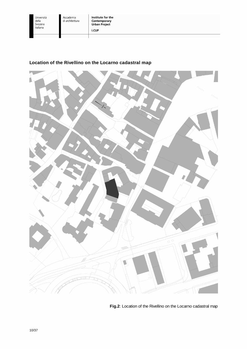
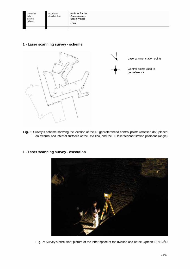
drawings of the inside of the building; the only other information heretofore available was from the surveyor office (cadastral plans, see fig. 2), where only the external area of the castle is represented (see fig. 3). At the end, the new plan of the Rivellino developed by the laser scanner helped to position accurately the spaces occupied within the defensive walls of Locarno Castle. 1 - Laser scanning survey The survey was executed with the use of an Optech laser (IIris 36D) with a motorised rotating base (pan-tilt) and a Leica TCR1205 total station (see fig. 4, 5). Target points were used to georeference and align the scans. The scanning process from the inside and outside of the Rivellino took six days, with an additional day for the implementation of a polygonal integrated into the national network of control points, in order to allow the survey of targets on the interior and exterior of the structure with absolute coordinates. A total of 50 scans with a step of 0.5 cm were taken from 30 station points (see fig. 6, 7). The alignment of the scans was done using Innovmetric’s Polyworks-Imalign software (see fig. 8, 9); most scans allowed the use of standard alignment algorithms based on the recognition of identical areas. The scans that didn’t have overlapping areas were adjusted using targets. 2 - From 3D survey to architectural drawing After the alignment and the georeferencing of the scans, a point cloud has been obtained. This point cloud was sliced along the three axes at a constant interval of 50 cm; the points found at a distance of less than 2 cm were projected onto these plans and then combined with broken lines to generate cross-sections (see fig. 10). Notwithstanding the errors introduced by the measurements and the data treatment, the accuracy of the cross-sections is close to the centimeter. The ultimate drawings of the Rivellino of Locarno Castle were produced after a manual reshaping of sections and plans according to the architectural interpretation and after having been adjusted to the cadastral plan (see fig. 11, 12, 13, and 14). 3 - From 3D survey to virtual model of the inner space The choice of parameters for the creation of a virtual model from laser scanning data is subordinate to the purpose the model is intended to serve; factors like interpolation, maximum distance between points and model accuracy are therefore determinant. In this case, the purpose of the survey was to produce highly detailed plans and sections and to create a 3D model to be built with rapid prototyping techniques; the basic data required for the realization of both are the same, but to obtain different degrees of precision two different scales were used: centimetric for the plans and sections, decimetric for the real model. One could theoretically make a digital model with a higher resolution, but the difficulty of producing a prototype in scale would outweigh any eventual gain in details. Immerge, a module of Polyworks, is the software used for reproducing the surfaces from the aligned point clouds; the interpolation step was set at 2 cm with a high degree of smoothing. This procedure creates a model with imperfections and holes (see fig. 15) that can be attributed to several factors: obstructions to laser measurement (lack of points), areas with very low incidence of radii compared to those of the laser (points more equidistant among themselves by comparison to the interpolation), zones closer than the minimum acquisition distance (again, a problem of absence of data). In almost all cases, the correction of these gaps can be done automatically using the appropriate hole-filling algorithm, which triangulates holes in the model by calculating the curves of the surrounding surfaces.

7/37
Manual intervention is necessary to correct voids due to geometries that are not recognizable by the hole-filling algorithm (see fig. 16). The 3D model has to be totally free of errors in order to make a real model obtained by using rapid prototyping techniques. Here follows a brief list of errors that may need to be corrected: flipped triangles: triangles whose normal is in the opposite direction to those adjacent; bad edges: triangles theoretically contiguous but with at least one side unshared with the adjacent element; noise shells: groups of independent triangles with problems in the zones where they join with the rest of the model; overlapping triangles: triangles on the same plan at very short distances from one another; intersecting triangles: triangles that intersect rather than join along one side. 4 - Virtual reconstruction of the environment In order to understand the actual situation and to give an image of the entire building, we have produced two virtual 3D reconstructions, one of the actual situation (see fig. 17), and one representing the results of a hypothetical demolition and excavation (see fig. 18). The final aspect of the Rivellino is based on the hypothesis of some specialists and historians, who maintain that the building was constructed on the lakeside, thus extending 9 meters below the actual ground level. In order to obtain all the data necessary for the production of the virtual reconstruction we have integrated the previous virtual model with the surrounding area of the Rivellino, produced by interpolated airborne laser scanner data. This latter model of the area is reconstructed by triangulating points from the DEM (Swisstopo Digital Elevation Model), with buildings inserted on the basis of ground coverage data from the cadastral map, attributing to them a height calculated from points belonging to the DSM (Digital Surface Model). 5 - From virtual model to physical model: the rapid prototyping process Rapid prototyping (RP) is an innovative technology that enables to produce, in just a few hours and without the use of any tool, objects of simple and/or complex geometry on the basis of a digital model of the object in question – for example, with a 3D CAD system. Among the various rapid prototyping technologies available today, 3D printers stand out for their printing speed and their range of applications. The printing process is very simple and shares much with many other techniques of rapid prototyping: the model is developed in height by the superposition of layers. Specifically, a 3D printer puts down uniform layers (0.08-0.1 mm) of chalk dust on a building platform, upon which a special binder is applied in the areas that will become the final prototype. The chalk in excess is subsequently removed and the model can then be waxed or coated with epoxy resins. This technology enables the creation of models of any geometry, since the chalk dust in excess acts as a support for the model itself, therefore not needing other supports during construction. The i.CUP has a new Zcorp 810 3D printer, which prints 3-dimensional models up to 500 x 600 x 400 mm (see fig. 19, 20). With this printer, starting from the virtual reconstructions, we realized different models (see fig. 21, 22):
• Inner space of rivellino (physical model scale 1: 100) • Actual situation and surrounding area (physical model scale 1: 200) • Situation after a hypothetical demolition and excavation (physical model scale 1: 200)

8/37
6 – Presentations The results of the survey have been summarized in two panels explaining the whole process (see fig. 23, 24) used to produce the three models exhibited in three thecae (see fig. 25). The material has been presented in several occasions:
1. Incontri Italo Svizzeri nella regione dei laghi prealpini, INSUBRIA INSIEME. Enrico Sassi, “Il Castello di Locarno, avamposto della Lombardia francese (1499-1513)”, Locarno (25.09.2006) 2. Convegno internazionale di studi, L’ARCHITETTURA MILITARE NELL’ETA’ DI LEONARDO. Enrico Sassi, “Laserscanning e 3D printing: tecniche tridimensionali applicate al rilievo del “Rivellino” del Castello di Locarno attribuito a Leonardo da Vinci”, Locarno (2/3.06.2007). 3. 3° International Optech Seminar on Laserscanner 3D. Francesco Vismara “3D survey of the Rivellino of Locarno castle”, Roma (6/7.06.2007). 4. Manifestation “Porte aperte al Rivellino”, on the occasion of the 500th anniversary of the Rivellino's foundation (Locarno 17 July 1507 – 17 July 2007) (see fig. 26) 5. Seminario Gruppo GIS Ticino “GIS e 3D”. Francesco Vismara, “Laserscanner terrestre e Rapid prototyping: acquisizione e trattamento dati, presentazione di un caso pratico, Il Rivellino di Locarno”, Mendrisio (13.09.2007).
An article about this work of survey has been published with the title “Saisie de données avec Laser scanner et impression 3D. Techniques 3D appliquées au levé du Rivellino du Château de Locarno conçu par Leonardo da Vinci” on the review “Geomatique Suisse”, Géoinformation et gestion du territoire, Number 11 - November 2007, pp. 558 – 561. Material of the survey has been published on the publication: M. Viganò (2007), “Locarno Francese (1499 – 1513)”, Archivio storico ticinese, Bellinzona. Conclusions The survey of the Rivellino fully demonstrates a further potential application of laser scan technology, which can be added to the established characteristic of measurement speed and precision: the possibility of using a single survey which serves as base for several elaborations, even spread out over time, since the original data remains unchanged and can therefore be archived and used again for other purposes. The only problem we encountered was the data processing: the software doesn’t seem to be appropriated to data acquisition technology. While the survey took only seven days, the data computing to achieve to the real model took more than one month.

9/37
Location of the Rivellino
Fig. 1: Location of the Rivellino on the Locarno base map - National Map 1:25’000
10/37
Location of the Rivellino on the Locarno cadastral map
Fig.2: Location of the Rivellino on the Locarno cadastral map

11/37
Rivellino of Locarno: external view
Fig. 3: Photography of the external view of the Rivellino

12/37
1 - Laser scanning survey - instrument
Fig. 4: Appearance of the instrument: Optech ILRIS 36D 1 - Laser scanning survey - functioning
Fig. 5: Laser scanning functioning. The laser pulse emitted by the laser is reflected as it meets an object. A photocell reads the reflections and registers angles and distances
13/37
1 - Laser scanning survey - scheme
Laserscanner station points
Control points used to georeference
Fig. 6: Survey’s scheme showing the location of the 13 georeferenced control points (crossed dot) placed
on external and internal surfaces of the Rivellino, and the 30 laserscanner station positions (angle)
1 - Laser scanning survey - execution
Fig. 7: Survey’s execution; picture of the inner space of the rivellino and of the Optech ILRIS 36D

14/37
1 - Laser scanning survey - alignment of the scans
Fig. 8: All the single scans (50) are aligned in order to produce the whole points cloud
Fig. 9: Wireframe: 3D visualization produced through an elaboration of the total points cloud

15/37
2 - From 3D survey to architectural drawing – cross sections
Fig. 10: Cross Section: the picture shows two different operations of slicing: vertical and horizontal section plans intersecting the point cloud. This operation enables the drawing of plans and sections

16/37
2 - From 3D survey to architectural drawing - plans
Fig. 11: Plan (200 m above sea level)
Fig. 12: Plan (202 m above sea level)

17/37
2 - From 3D survey to architectural drawing – sections
Fig. 13: AA’ Section
Fig. 14: BB’ Section

3 - From 3D survey to virtual model of the inner space
Fig. 15: Raw virtual model with imperfections and holes
Fig. 16: Final virtual model after the application of the hole-filling algorithm and manual intervention

19/37
4 – Virtual reconstruction of the environment
Fig. 17: Virtual reconstruction of the current urban environment with buildings surrounding the rivellino (at the centre of the picture and highlighted in dark gray)
Fig. 18: Virtual reconstruction of the same area representing the results of a hypothetical demolition and excavation showing the lake level and the complete volume of the rivellino

20/37
5 - From virtual model to physical model: the rapid prototyping process
Fig. 19: Rapid prototyping; 3D printer i.CUP – Zcorp 810 able to produce 3D physical models printing different superposed layers by fixing a chalk dust (500 x 600 x 400 mm max dimensions)
Fig. 20: Rapid prototyping; realization of physical model from the virtual 3D reconstruction with the 3D printer i.CUP – Zcorp 810

21/37
5 - From virtual model to physical model: the rapid prototyping process
Fig. 21: physical model of the virtual reconstruction of the area surrounding the rivellino printed by i.CUP with 3D printer Z-Print 810 (scale 1 : 200)
Fig. 22: physical model of the virtual reconstruction of the inner space of the rivellino of Locarno, printed by i.CUP with 3D printer Z-Print 810 (scale 1 : 100)

22/37
6 – Presentations – panel 1
Fig. 23: Panel one exhibited during the International Congress "L'architettura militare nell'età di Leonardo" (Locarno, 2/3 June 2007)

23/37
6 – Presentations – panel 2
Fig. 24: Panel two exhibited during the International Congress "L'architettura militare nell'età di Leonardo" (Locarno, 2/3 June 2007)

24/37
6 – Presentations - thecae
Fig. 25: Thecae exhibited during the International Congress "L'architettura militare nell'età di Leonardo" (Locarno, 2/3 June 2007)
Fig. 26: Major of Locarno during the event “Porte aperte al Rivellino”, on occasion of the 500th anniversary of the rivellino’s foundation (Locarno 17 July 1507 – 17 July 2007)

25/37
Bibliography: F. Rinaudo (2003). La tecnica del laser scanning: applicazioni architettoniche e urbanistiche. Pubblicato nel volume F. Crosilla, R. Galetto. La tecnica laser scanning. Teoria e applicazioni. (pp. 157-172). ISBN: 88-85137-27-X. UDINE: CISM (ITALY) L. Bornaz (2006). Principi di funzionamento e tecniche di acquisizione. Pubblicato nel volume F. Crosilla, S. Dequal. Laser scanning terrestre. (pp. 1-18). ISBN: 88-85137-19-9. UDINE: CISM (ITALY) A. Beinat (2006). Tecniche di registrazione. Pubblicato nel volume F. Crosilla, S. Dequal. Laser scanning terrestre. (pp. 39-53). ISBN: 88-85137-19-9. UDINE: CISM (ITALY) M. A. Gomerasca (2004). Elementi di geomatica. AIT (Associazione Italiana di Telerilevamento) R. Cantoni, G. Vassena, C. Lanzi (2002). Integrazione tra laser scannino e metodologie di rilievo tradizionali nella ricostruzione 3D. ASITA Federazione delle Associazioni Scientifiche per le Informazioni Territoriali e Ambientali – Perugia, Italy. D. Conforti Andreoni, L. Pinto (2004). The creation of the digital models for the protection of cultural heritage: the Baptistery of Cremona. In: International Archives of Photogrammetry and Remote Sensing, vol. 35 B5, Comm. V, Istanbul – Turkey. pp. 489-493. D. Conforti Andreoni, G. Massari, M. Potleca (2003). Generazione di modelli digitali del terreno dalla combinazione di dati lidar da piattaforma aerea e terrestri. ASITA Federazione delle Associazioni Scientifiche per le Informazioni Territoriali e Ambientali – Verona, Italy. Innovmetric Software http://www.innovmetric.com Rapid Prototyping. http://www.zcorp.com http://www.materialise.com

26/37
3D survey of the rivellino of Locarno Castle“Restoration and Transformation” project
Press review and publications
i.CUP – Institute for the Contemporary Urban Project
Pieghevole del del Convegno internazionale di studi L’ARCHITETTURA MILITARE NELL’ETA’ DI LEONARDO (2/3 Giugno 2007)

27/37
Pieghevole del del Convegno internazionale di studi L’ARCHITETTURA MILITARE NELL’ETA’ DI LEONARDO (2/3 Giugno 2007)
Allestimento del rilievo in occasione del Convegno internazionale di studi L’ARCHITETTURA MILITARE NELL’ETA’ DI LEONARDO (2/3 Giugno 2007)

28/37
Allestimento del rilievo in occasione del Convegno internazionale di studi L’ARCHITETTURA MILITARE NELL’ETA’ DI LEONARDO (2/3 Giugno 2007)
“Corriere del Ticino”, 04-06-07
“Il giornale del popolo”, 04-06-07

29/37
“Il giornale del popolo”, 04-06-07
“Il giornale del popolo”, 04-06-07

30/37
“Corriere del Ticino”, 04-06-07
“La Regione Ticino”, 04-06-07

31/37
Marino Vigano’ (2007), “Locarno francese (1499 – 1513)”, Archivio storico ticinese - Bellinzona
Manifestazione “Porte aperte al rivellino” in occasione del 500° di fondazione del rivellino(Locarno, 17 luglio 1507 – 17 luglio 2007) –Nell’immagine a destra il Sindaco di Locarno Carla Speziali
32/37
“Corriere del Ticino”, 04-08-07
“Corriere del Ticino”, 04-08-07

33/37
Incontri Italo Svizzeri nella regione dei laghi prealpini
INSUBRIA INSIEME
25 settembre 2006
Palazzo Società Elettrica Sopracenerina
Piazza Grande 5 - Locarno
Presentazioni:
Presentazione di Enrico Sassi, i.CUPinstitute for the Contemporary Urban Project,all’interno dell’intervento:
“Il Castello di Locarno, avamposto della Lombardia francese (1499-1513)”
Marino Vigano’, Docente della Scuola di specializzazione dell’Università Cattolica di Milano
Convegno internazionale di studi
L’ARCHITETTURA MILITARE NELL’ETA’ DI LEONARDO
2/3 Giugno 2007
Aula magna dell’alta scuola pedagogica
Piazza S. Francesco 19 - Locarno
“Laserscanning e 3D printing: tecnichetridimensionali applicate al rilievo del “Rivellino” del Castello di Locarno attribuito a Leonardo da Vinci”
Enrico Sassi, Francesco Vismara, i.CUPinstitute for the Contemporary Urban Project
Presentazioni:

34/37
Seminario Internazionale
3° International Optech Seminar on Laserscanner 3D
6/7 Giugno 2007
Istituto Nazionale di Geofisica e Vulcanologia
Via di Vigna Murata,605 – Roma (Italy)
“3D survey of the Rivellino of Locarno castle”
Francesco Vismara, i.CUPinstitute for the Contemporary Urban Project
Presentazioni:
Seminario
Gruppo GIS Ticino
“GIS e 3D”
13 Settembre 2007
Aula magna Centro Scolastico Canavée
Viale Canavée, 8 – Mendrisio
“Laserscanner terrestre e Rapid prototyping: acquisizione e trattamento dati, presentazione di un caso pratico: Il Rivellino di Locarno”
Francesco Vismara, i.CUPinstitute for the Contemporary Urban Project
Presentazioni:

35/37
E. Sassi, F. Vismara, K. Dalle Fusine
“Saisie de données avec Laser scanner et impression 3D Techniques 3D appliquées au levédu Rivellino du Château de Locarnoconçu par Leonardo da Vinci”
“Geomatique Suisse”
Géoinformation et gestion du territoire
Numero 11 - Novembre 2007
pp. 558 - 561
Pubblicazioni:

36/37

37/37
Press review International Congress "L'architettura militare nell'età di Leonardo" (Locarno, 2/3 giugno 2007) 1. Raffaella Machiné, Si attende una risposta «forte» dal convegno di specialisti. Rivellino, sempre più certa la paternità di Leonardo, «Giornale del popolo. Quotidiano della Svizzera italiana» [Lugano] LXXXII, venerdi 1° giugno 2007, p. 10 2. Leonardo e l’architettura militare. Locarno, oggi e domani il convegno internazionale per i 500 anni del «rivellino» del Castello, «la Regione Ticino» [Bellinzona] XIV, sabato 2 giugno 2007, p. 17 3. Raffaella Machiné, Molte le conferme degli esperti di architettura militare nella due-giorni di studi. Leonardo autore del rivellino, tutti gli indizi lo confermano, «Giornale del popolo. Quotidiano della Svizzera italiana» [Lugano] LXXXII, lunedi 4 giugno 2007, p. 9 4. Mauro Euro, Leonardo, l’ipotesi si rafforza. La conferma del prof. Carlo Pedretti al termine del convegno, «Corriere del Ticino. Quotidiano indipendente della Svizzera italiana» [Lugano] CXVI, lunedi 4 giugno 2007, p. 21 5. Spartaco Calvo, Acqua per le radici del rivellino. Locarno, di grande spessore il convegno internazionale di studi per il 500° del bastione, «la Regione Ticino» [Bellinzona] XIV, lunedi 4 giugno 2007, p. 13 6. Carlo Pedretti, Leonardo, nuove scoperte al Castello. Ritrovato l’antico baluardo in cui il genio avrebbe collocato il cavallo ora a San Siro/Il cavallo di Leonardo da San Siro al Castello. Scoperto l’antico bastione creato per ospitarlo. Ritrovata la pianta del baluardo: davanti alla piazza può diventare un simbolo di Milano, «Corriere della Sera» [Milano] CXXXII, domenica 15 luglio 2007, inserto «Milano - Lombardia», pp. 1 e 7 7. Porte aperte e un libro per i 500 anni del rivellino. Duplice appuntamento domani per sottolineare la storica ricorrenza, «Corriere del Ticino. Quotidiano indipendente della Svizzera italiana» [Lugano] CXVI, lunedi 16 luglio 2007, p. 13 8. Mauro Euro, «Intendiamo acquisire il rivellino del Castello». Lo ha ribadito il sindaco Carla Speziali durante la festa per il 500° di fondazione del monumento, «Corriere del Ticino. Quotidiano indipendente della Svizzera italiana» [Lugano] CXVI, mercoledi 18 luglio 2007, p. 17 9. Locarno, il compleanno del Rivellino. Ieri «porte aperte» per i 500 anni del bastione attribuito a Leonardo, «la Regione Ticino» [Bellinzona] XIV, mercoledi 18 luglio 2007, p. 11 10. Rivellino, urgano scavi. Prime reazioni dopo il convegno di Locarno, «Corriere del Ticino. Quotidiano indipendente della Svizzera italiana» [Lugano] CXVI, sabato 4 agosto 2007, n. 176, p. 15 11. Mauro Euro, Il rivellino avvicina Ticino e Lombardia. Politici svizzeri e italiani in visita al monumento durante il Festival del film hanno manifestato interesse per la sua salvaguardia e promozione. Ma è soprattutto da Milano che si guarda a quest’opera con grande attenzione, «Corriere del Ticino. Quotidiano indipendente della Svizzera italiana» [Lugano] CXVI, giovedi 16 agosto 2007, p. 19


