Chapter 4: Environmental Consequences 410 Glen Canyon National Recreation Area WILDERNESS GUIDING REGULATIONS AND POLICIES The Wilderness Act, passed on September 3, 1964, established a national wilderness preservation system, “administered for the use and enjoyment of the American people in such manner as will leave [these areas] unimpaired for future use and enjoyment as wilderness, and so as to provide for the protection of these areas, the preservation of their wilderness character, and for the gathering and dissemination of information regarding their use and enjoyment as wilderness” (16 USC 1131). The Wilderness Act further defined wilderness as “an area of undeveloped Federal land retaining its primeval character and influence, without permanent improvements or human habitation, and which is protected and managed to preserve its natural conditions” (16 USC 1131). The Wilderness Act gives the agency managing the wilderness responsibility for preserving the wilderness character of the area and devoting the area to the public purposes of recreational, scenic, scientific, educational, conservation, and historical use (16 USC 1133). Certain uses are specifically prohibited, except for areas where these uses have already become established. The act states that “there shall be no commercial enterprise and no permanent road within any wilderness area designated by this chapter and except as necessary to meet minimum requirements for the administration of the area… There shall be no temporary road, no use of motor vehicles, motorized equipment or motorboats, no landing of aircraft, no other form of mechanical transport, and no structure or installation within any such area” (16 USC 1133). The United States Forest Service national framework applied the legal definition of wilderness character to identify four tangible qualities of wilderness that make the idealized description of wilderness character relevant and practical to wilderness stewardship (Landres et al. 2008): Untrammeled – The Wilderness Act states that wilderness is “an area where the earth and its community of life are untrammeled by man,” and “generally appears to have been affected primarily by the forces of nature.” In short, wilderness is essentially unhindered and free from modern human control or manipulation. This quality is degraded by modern human activities or actions that control or manipulate the components or processes of ecological systems inside the wilderness. Natural – The Wilderness Act states that wilderness is “protected and managed so as to preserve its natural conditions.” In short, wilderness ecological systems are substantially free from the effects of modern civilization. This quality is degraded by intended or unintended effects of modern people on the ecological systems inside the wilderness since the area was designated. Undeveloped – The Wilderness Act states that wilderness is “an area of undeveloped Federal land retaining its primeval character and influence, without permanent improvements or human habitation,” “where man himself is a visitor who does not remain” and “with the imprint of man’s work substantially unnoticeable.” This quality is degraded by the presence of structures, installations, habitations, and by the use of motor vehicles, motorized equipment, or mechanical transport that increases the ability of people to occupy or modify the environment. Solitude or a primitive and unconfined type of recreation – The Wilderness Act states that wilderness has “outstanding opportunities for solitude or a primitive and unconfined type of recreation.” This quality is about the opportunity for people to experience wilderness; it is not directly about visitor experiences per se. This quality is degraded by settings that reduce these opportunities, such as visitor encounters, signs of modern civilization, recreation facilities, and management restrictions on visitor behavior. These four qualities together comprise an approximation of wilderness character for wilderness planning, stewardship, and monitoring. All four qualities are equally important and none is held in higher or lower regard than the others. In addition to these four tangible wilderness qualities, there are important intangible aspects of wilderness character that would be difficult or even impossible to quantify or monitor. These intangible aspects are
Transcript
Chapter 4: Environmental Consequences
410 Glen Canyon National Recreation Area
WILDERNESS
GUIDING REGULATIONS AND POLICIES
The Wilderness Act, passed on September 3, 1964, established a national wilderness preservation system, “administered for the use and enjoyment of the American people in such manner as will leave [these areas] unimpaired for future use and enjoyment as wilderness, and so as to provide for the protection of these areas, the preservation of their wilderness character, and for the gathering and dissemination of information regarding their use and enjoyment as wilderness” (16 USC 1131). The Wilderness Act further defined wilderness as “an area of undeveloped Federal land retaining its primeval character and influence, without permanent improvements or human habitation, and which is protected and managed to preserve its natural conditions” (16 USC 1131). The Wilderness Act gives the agency managing the wilderness responsibility for preserving the wilderness character of the area and devoting the area to the public purposes of recreational, scenic, scientific, educational, conservation, and historical use (16 USC 1133). Certain uses are specifically prohibited, except for areas where these uses have already become established. The act states that “there shall be no commercial enterprise and no permanent road within any wilderness area designated by this chapter and except as necessary to meet minimum requirements for the administration of the area… There shall be no temporary road, no use of motor vehicles, motorized equipment or motorboats, no landing of aircraft, no other form of mechanical transport, and no structure or installation within any such area” (16 USC 1133).
The United States Forest Service national framework applied the legal definition of wilderness character to identify four tangible qualities of wilderness that make the idealized description of wilderness character relevant and practical to wilderness stewardship (Landres et al. 2008):
Untrammeled – The Wilderness Act states that wilderness is “an area where the earth and its community of life are untrammeled by man,” and “generally appears to have been affected primarily by the forces of nature.” In short, wilderness is essentially unhindered and free from modern human control or manipulation. This quality is degraded by modern human activities or actions that control or manipulate the components or processes of ecological systems inside the wilderness.
Natural – The Wilderness Act states that wilderness is “protected and managed so as to preserve its natural conditions.” In short, wilderness ecological systems are substantially free from the effects of modern civilization. This quality is degraded by intended or unintended effects of modern people on the ecological systems inside the wilderness since the area was designated.
Undeveloped – The Wilderness Act states that wilderness is “an area of undeveloped Federal land retaining its primeval character and influence, without permanent improvements or human habitation,” “where man himself is a visitor who does not remain” and “with the imprint of man’s work substantially unnoticeable.” This quality is degraded by the presence of structures, installations, habitations, and by the use of motor vehicles, motorized equipment, or mechanical transport that increases the ability of people to occupy or modify the environment.
Solitude or a primitive and unconfined type of recreation – The Wilderness Act states that wilderness has “outstanding opportunities for solitude or a primitive and unconfined type of recreation.” This quality is about the opportunity for people to experience wilderness; it is not directly about visitor experiences per se. This quality is degraded by settings that reduce these opportunities, such as visitor encounters, signs of modern civilization, recreation facilities, and management restrictions on visitor behavior.
These four qualities together comprise an approximation of wilderness character for wilderness planning, stewardship, and monitoring. All four qualities are equally important and none is held in higher or lower regard than the others. In addition to these four tangible wilderness qualities, there are important intangible aspects of wilderness character that would be difficult or even impossible to quantify or monitor. These intangible aspects are
Wilderness
Off-road Vehicle Management Plan/DEIS 411
diverse and include the scenic beauty and immensity of an area and the opportunity for self-discovery, self-reliance, and challenge that comes from wilderness settings. These intangible aspects are important contributors to the inspirational and psychological benefits that many people experience in wilderness (Landres et al. 2008).
Wilderness character may be either preserved or degraded by the actions or inactions of managers. For example, the choices to not use a chain saw, build a footbridge across a stream, or suppress a naturally ignited fire may preserve certain qualities of wilderness character. In contrast, other management actions, such as requiring visitors to use designated campsites or authorizing administrative use of motorized equipment and mechanical transportation, may diminish certain qualities of wilderness character.
The challenge of wilderness stewardship, however, is that decisions and actions taken to protect one aspect of wilderness character may diminish another aspect. For example, a bridge built to protect a stream bank from erosion caused by people or horses crossing the stream may also diminish the opportunity for people to experience the challenge of crossing a stream. Similarly, the required use of designated campsites to prevent the proliferation of sites and associated impacts on soil and vegetation may also diminish the opportunity for unconfined recreation and the sense of freedom from the constraints of regulation. In addition, the accumulated result of seemingly small decisions and actions may cause a significant gain or loss of wilderness character over time. Because of this complexity, preserving wilderness character requires that managers approach wilderness stewardship with humility, respect, and restraint (Landres et al. 2008).
Section 6.3.5 of NPS Management Policies 2006 requires that all management decisions affecting wilderness must be consistent with the minimum requirement concept. This concept is a documented process used to determine if administrative actions, projects, or programs undertaken by NPS or its agents and affecting wilderness character, resources, or the visitor experience are necessary, and if so how to minimize impacts (NPS 2006a). This analysis was conducted for all alternatives using the Minimum Requirements Decision Guide from the Arthur Carhart National Wilderness Training Center.
As described in section 6.3.7 of NPS Management Policies 2006, “The principle of nondegradation will be applied to wilderness management.… Natural processes will be allowed, insofar as possible, to shape and control wilderness ecosystems. Management should seek to sustain the natural distribution, numbers, population composition, and interaction of indigenous species. Management intervention should only be undertaken to the extent necessary to correct past mistakes, the impacts of human use, and influences originating outside of wilderness boundaries” (NPS 2006a).
Director’s Order 41: Wilderness Preservation and Management (NPS 1999b) was developed to provide accountability, consistency, and continuity to NPS wilderness management efforts and to otherwise guide NPS efforts in meeting the requirements set forth by the Wilderness Act of 1964.
Director’s Order 41 sets forth guidance for applying the minimum requirement concept to protect wilderness and for the overall management, interpretation, and uses of wilderness. With regard to natural resource management in wilderness, it reaffirms management policies and states, “Management intervention should only be undertaken to the extent necessary to correct past mistakes, the impacts of human use, and the influences originating outside of wilderness boundaries” (NPS 1999b).
METHODOLOGY AND ASSUMPTIONS
In considering environmental impacts on wilderness, which includes proposed and potential wilderness since NPS treats potential and proposed wilderness equally and manages both as if they are wilderness, NPS Management Policies 2006 requires that the analysis take into account (1) wilderness characteristics and values, including the primeval character and influence of the wilderness; (2) the preservation of natural conditions (including the lack of man-made noise); and (3) assurances that there will be outstanding opportunities for solitude, that the public will
Chapter 4: Environmental Consequences
412 Glen Canyon National Recreation Area
be provided with a primitive and unconfined type of recreational experience, and that wilderness will be preserved and used in an unimpaired condition (NPS 2006a).
All of the unpaved GMP roads that appear to be within proposed wilderness are in fact adjacent to proposed wilderness areas; they are “cherry stemmed” in the proposed wilderness areas. “Cherry-stemming” is a method of excluding non-conforming uses such as roads from areas proposed as wilderness (NPS 2007g). Further, the unpaved GMP roads are the official unpaved GMP roads as designated in the 1979 Glen Canyon GMP, and the wilderness recommendation wasn’t established until 1980; therefore those unpaved GMP roads were already in use and continue to be in use, even if crossing through proposed wilderness. Consequently, the analysis of impacts on wilderness will be presented as impacts of motorized use on unpaved GMP roads adjacent to proposed wilderness areas that are already being managed as wilderness. The existing unpaved GMP roads will be included in the baseline condition for the analysis, since they were designated as unpaved GMP roads prior to the wilderness recommendation (Landres et al. 2008). No paved GMP roads are located within proposed wilderness; however, there are segments of paved GMP roads that are adjacent to proposed wilderness.
During internal scoping and subsequent consultations with NPS staff, it was determined that, under the proposed actions in this plan/DEIS, noise from motor vehicles would be the only impact on proposed wilderness under all alternatives. Noise from motor vehicles has the potential to disturb proposed wilderness characteristics and values, primarily the potential for visitors to experience solitude and an untrammeled, natural, and undeveloped setting. Further, we must acknowledge in this plan/DEIS that there is potential for ORVs to travel off designated routes and GMP roads, which could expand impacts on proposed wilderness areas. However each alternative contains monitoring and mitigation strategies to preclude and reduce these incidents from being consistent long-term impacts. Therefore, with these monitoring and mitigation strategies in place, NPS staff determined that the impacts from ORVs traveling off designated routes and GMP roads is not likely to be a threat to proposed wilderness areas, and as such, will not be discussed further within this Wilderness section.
Similar to the methodologies and assumptions used for the soundscapes analysis, the metric chosen for noise impacts on proposed wilderness areas is the A-weighted Lmax (maximum sound level during the pass-by of one ORV). While consideration of other indicators could be desirable, there is insufficient information on the number of ORVs using each area/road and the precise location of the vehicles at specific times to accurately model time-dependent metrics such as Leq or percent time audible. The analysis of Lmax provides a reasonable basis for comparing the sound levels resulting from the various alternatives that involve restrictions on operating areas and vehicle sound emissions limits.
As stated in the soundscapes analysis, the composite source for proposed limits on ORV sound levels is referred to as the “96 dBA composite source” and is used for this analysis because the concept of imposing a 96 dBA limit (measured 0.5 meters from the tailpipe) is under consideration at Glen Canyon. The “96 dBA composite source” results in a Lmax of 75.2 dBA at a distance of 6 meters from the source.
The NPS Natural Sounds Program created a spreadsheet noise model (described further in the soundscapes analysis of this chapter), which was used to determine the distance from the source at which OHV and street-legal ATV noise would decrease to be equivalent to the natural ambient level. The natural ambient level selected for the analysis based on the monitoring data was a uniform 20 dBA across all areas of Glen Canyon. The 20 dBA natural ambient level is representative of daytime summer conditions. Although higher natural ambient levels were estimated in some areas of Glen Canyon near Lone Rock, those estimates were not considered reliable because human-caused sounds were audible for greater than 75% of the time in those locations. The 20 dBA natural ambient level is supported by the majority of the monitoring sites.
Based on the input assumptions described above, it takes 8,020 feet for the average composite ORV noise to drop down to be equal to the natural ambient level of 20 dBA. With the proposed 96 dBA tailpipe noise limit, this distance is reduced 5,460 feet. For ORV areas open to conventional motor vehicles only operating at a maximum
Wilderness
Off-road Vehicle Management Plan/DEIS 413
speed of 15 mph (such as Lone Rock Beach under alternative D, and accessible shorelines under alternatives A and D), noise levels would drop to equal the natural ambient level of 20 dBA at 2,900 feet from the source. These off-road uses of conventional motor vehicles on accessible shorelines were evaluated as part of direct impacts. As part of the assessment of cumulative impacts, conventional motor vehicle-only GMP roads were analyzed. Conventional vehicle use on GMP roads was not included as part of direct impacts because it is not the subject of this EIS. Thus, the cumulative impact scenario for each alternative includes all the direct impacts, plus the use of conventional motor vehicles on GMP roads. Although the speed limit on GMP roads varies, these roads were conservatively assumed to operate at 55 mph (except in Orange Cliffs Unit where 15 mph is the speed limit) (NPS 2013a). At 55 mph, conventional motor vehicle noise would take 10,850 feet to drop to equal the natural ambient level.
Within these distances, OHVs and street-legal ATVs would result in a 3 dBA or greater increase in sound levels over the natural ambient level. This is because decibels are expressed on a logarithmic scale and cannot be added together directly. Through “decibel addition,” two sources at the same sound level combine to create a total sound level 3 dBA higher. A 3 dBA increase in the natural ambient level is an important indicator because it results in a 50% reduction in listening area.
The focus of the direct and cumulative impact analyses was on determining the impact of motorized vehicle use on soundscapes within the Glen Canyon boundaries only. Given the prevalence of motor vehicle use on surrounding federal lands and the already elevated noise levels associated with such uses, analysis of impacts on areas outside the boundaries of Glen Canyon was not the focus of this study.
Similar to soundscapes analysis, the analysis for proposed wilderness includes direct and cumulative impacts. Direct impacts on wilderness included only impacts from OHVs and street-legal ATVs noise on Lone Rock Beach, play area, accessible shorelines, GMP roads, and designated ORV routes, where a change in management actions are being considered. The analysis of direct impacts did not include GMP roads accessible to conventional motor vehicles only because these roads would not be changed within the scope of this plan/DEIS. However, a separate impact calculation was performed for purposes of analyzing cumulative wilderness impacts that included roads and accessible shoreline areas allowed to be used by conventional motor vehicles only and not by OHVs or street-legal ATVs.
Acreages, miles, and percentages presented in the following analysis are estimates and are based on the best available GIS information the park has acquired to date. These numbers may change slightly as new GIS information becomes available allowing more refined analysis.
Context
The geographic study area for proposed wilderness is contained within the areas of Glen Canyon that have been identified as proposed wilderness in the 1980 Wilderness Recommendation Plan. As stated in NPS Management Policies 2006 chapter 6 and Director’s Order 41, lands that are identified as “proposed wilderness” will be managed as wilderness in accordance with the wilderness preservation provisions, and lands proposed by the Director but not forwarded as “proposed wilderness” by the Secretary to the President will be managed to preserve their wilderness resources and values.
ALTERNATIVE A: NO ACTION
Lone Rock Beach
There would be no impacts on proposed wilderness at Lone Rock Beach under alternative A, because there are no proposed wilderness areas at Lone Rock Beach.
Chapter 4: Environmental Consequences
414 Glen Canyon National Recreation Area
Lone Rock Beach Play Area
There would be no impacts on proposed wilderness at the Lone Rock Beach Play Area under alternative A, because there are no proposed wilderness areas at the Lone Rock Beach Play Area.
Accessible Shorelines
Under alternative A, 13 accessible shoreline areas would remain open to conventional motor vehicle use (Blue Notch, Bullfrog North and South, Copper Canyon, Crosby Canyon, Dirty Devil, Farley Canyon, Neskahi, Paiute Canyon, Red Canyon, Stanton Creek, Warm Creek, White Canyon, and Hite Boat Ramp). Impacts on proposed wilderness areas adjacent to accessible shorelines would occur in areas where noise from conventional motor vehicles is audible to visitors within proposed wilderness areas, which would degrade the natural condition of the proposed wilderness areas (including the introduction of man-made noise), negatively impact the opportunity for visitors to experience natural quiet and solitude, and compromise the primeval and untrammeled characteristics of the proposed wilderness areas. Under alternative A, only the Dirty Devil, Hite Boat Ramp, Blue Notch and Red Canyon accessible shorelines would create impacts from conventional motor vehicle use to proposed wilderness areas, because these are the only accessible shorelines that are adjacent to proposed wilderness areas that would be open to conventional motor vehicle use. Further, these accessible shoreline areas generally do not experience high vehicle use, so the impacts on the proposed wilderness areas adjacent to these accessible shorelines are expected to be low. Visitors in proposed wilderness areas would likely only hear noise from vehicles infrequently and temporarily, because the vehicles would typically drive to the beach and park, thus the duration of impacts would be low. Impacts from conventional vehicles operating at 15 mph would extend up to 2,900 feet from each shoreline areas before reaching the 20 dBA natural ambient level, during times when the vehicles are operating. Occasional illegal use under alternative A could result in areas adjacent to the designated accessible shorelines, or along other shorelines where motorized vehicles are not permitted. The extent to which illegal use would occur is not known. Access to Pauite Farms and Nokai Canyon would be discontinued and no direct impacts on soundscapes would occur
Travel on GMP Roads in Glen Canyon
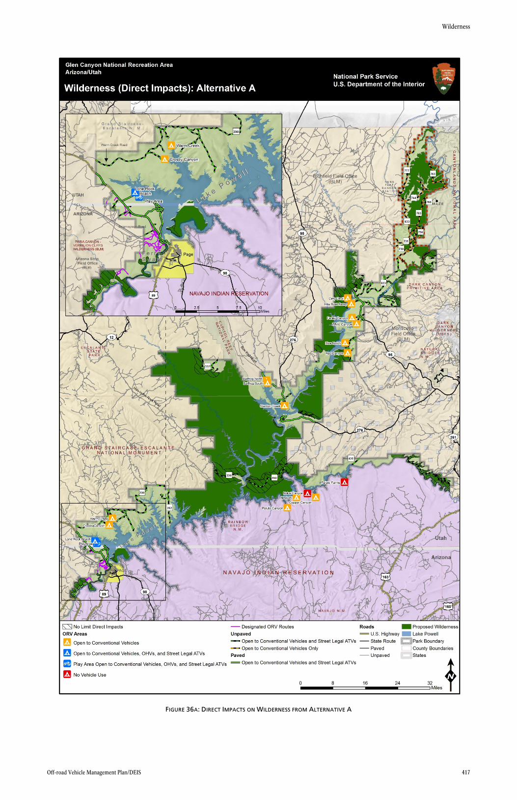
Under alternative A, proposed wilderness areas adjacent to GMP roads would experience negative impacts from street-legal ATV use. Areas that would be directly and negatively impacted include (please refer to figure 36a for exact locations):
The proposed wilderness area surrounding Routes 330 and 450, separating the Escalante and Warm Creek areas
The proposed wilderness area east of Paiute Farms (just west of Rout 261)
The proposed wilderness area adjacent to Route 332 in the Escalante region
The proposed wilderness area adjacent to Route 276, southeast of Stanton Creek
The proposed wilderness area across Lake Powell from Blue Notch
The proposed wilderness areas adjacent to ORV routes in the Hite region
One proposed wilderness areas within Ferry Swale that is near GMP roads
Impacts on proposed wilderness areas adjacent to GMP roads would occur in areas where street-legal ATV noise is audible to visitors, which would degrade the natural condition of the proposed wilderness areas (including the introduction of man-made noise), negatively impact the opportunity for visitors to experience natural quiet and solitude, and compromise the primeval and untrammeled characteristics of the proposed wilderness areas. Without
Wilderness
Off-road Vehicle Management Plan/DEIS 415
the 96 dBA noise limit mitigation measure, noise from street-legal ATVs is expected to travel 8,020 feet from the GMP roads before it reaches the 20 dBA natural ambient level (see figure 36a). However, visitors in proposed wilderness areas would likely only hear noise from street-legal ATVs infrequently (based on the analysis in the “Soundscapes” section of this chapter) and temporarily, because the vehicles would be traveling through the area (pass-by).
Ferry Swale
Under alternative A, approximately 53 miles of ORV routes would be designated and authorized for use by conventional motor vehicles, OHVs, and street-legal ATVs. Proposed wilderness areas east and south of designated ORV routes would be authorized for use. As a result, proposed wilderness areas in Ferry Swale would experience negative impacts from off-road use due to the noise particularly from the OHVs and street-legal ATVs, which would degrade the natural condition of the proposed wilderness areas (including the introduction of man-made noise), negatively impact the opportunity for visitors to experience natural quiet and solitude, and compromise the primeval and untrammeled characteristics of the proposed wilderness areas. Without the 96-dBA noise limit mitigation measure, noise from OHVs and street-legal ATVs is expected to travel 8,020 feet from the authorized routes before it reaches the 20 dBA natural ambient level (see figure 36a). The extent of impacts could be greater than shown in figure 36a as a result of occasional illegal off-road use. The impacts from vehicular use on these routes would be minimal with the 96 dBA noise limit.
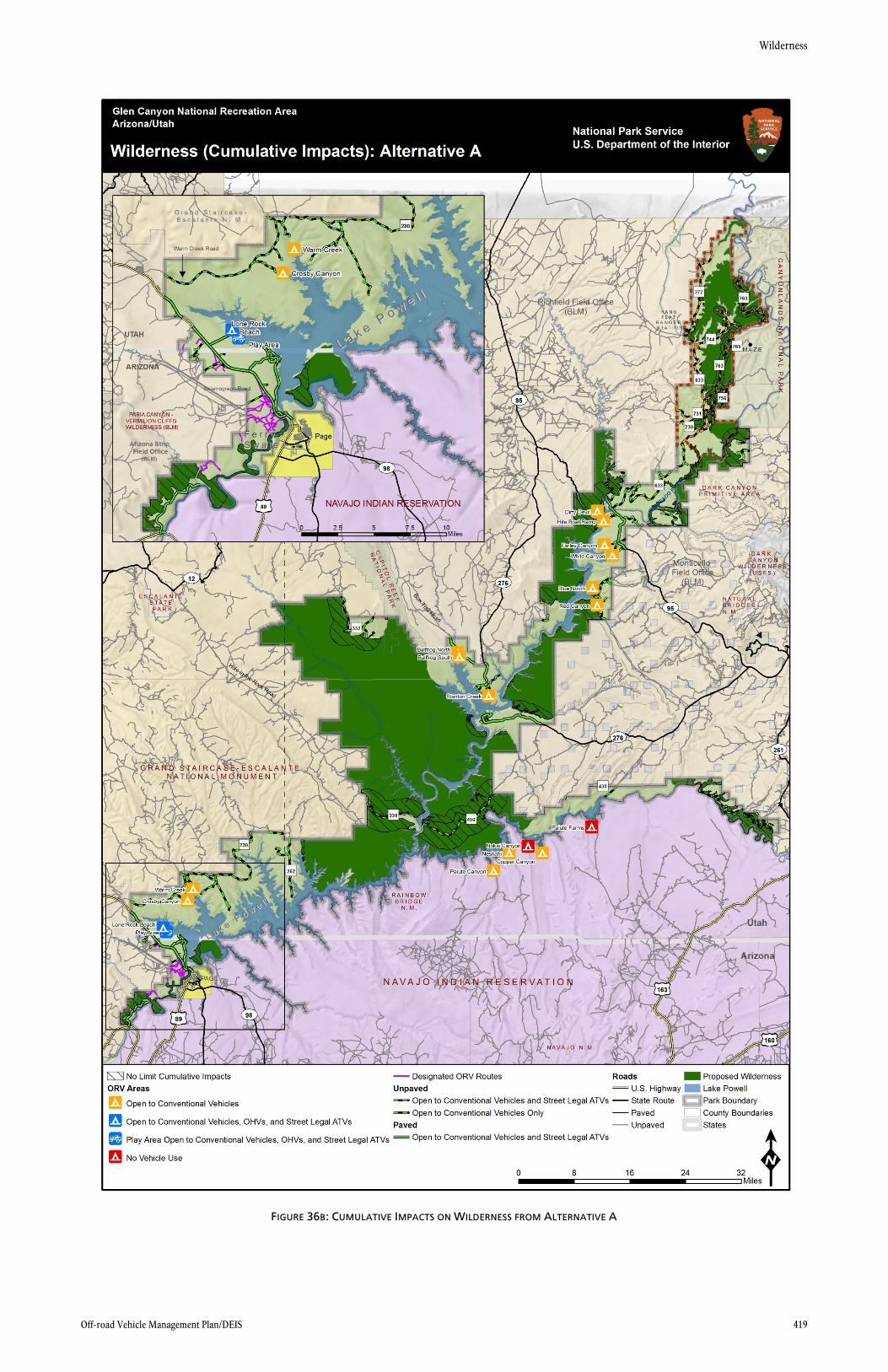
Cumulative Impacts
Other past, present, and planned future activities within Glen Canyon have the potential to affect the quality of proposed wilderness areas. Cumulative impacts for proposed wilderness within Glen Canyon are the same as those presented under the “Soundscapes” section of this chapter (represented in figure 36b). Additionally, illegal off-road use into proposed wilderness areas could be currently occurring, which is a cumulative impact under alternative A. Occasionally ORVs will illegally drive into proposed wilderness areas (particularly on Rincon Road, which has been closed by the GMP), which results in adverse impacts on proposed wilderness. Without the 96 dBA limit, 25.72% of proposed wilderness areas would be impacted by motor vehicle noise (this includes all roads, ORV routes, and ORV areas within Glen Canyon). Refer to the “Soundscapes” section for full descriptions on cumulative impacts that have the potential to impact proposed wilderness areas in Glen Canyon. The impacts of these actions, in combination with the adverse impacts on proposed wilderness areas under alternative A, would result in, adverse cumulative impacts on proposed wilderness.
Chapter 4: Environmental Consequences
416 Glen Canyon National Recreation Area
Wilderness
Off-road Vehicle Management Plan/DEIS 417
FIGURE 36A: DIRECT IMPACTS ON WILDERNESS FROM ALTERNATIVE A
Chapter 4: Environmental Consequences
418 Glen Canyon National Recreation Area
Wilderness
Off-road Vehicle Management Plan/DEIS 419
FIGURE 36B: CUMULATIVE IMPACTS ON WILDERNESS FROM ALTERNATIVE A
Chapter 4: Environmental Consequences
420 Glen Canyon National Recreation Area
Wilderness
Off-road Vehicle Management Plan/DEIS 421
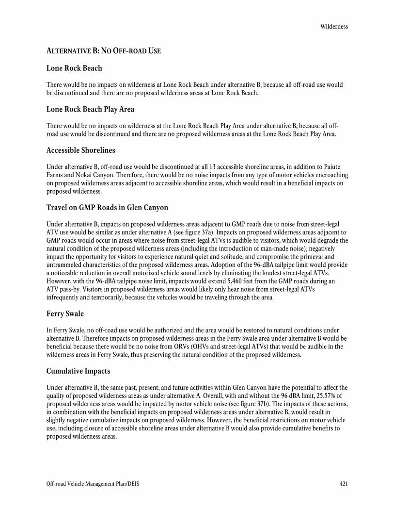
ALTERNATIVE B: NO OFF-ROAD USE
Lone Rock Beach
There would be no impacts on wilderness at Lone Rock Beach under alternative B, because all off-road use would be discontinued and there are no proposed wilderness areas at Lone Rock Beach.
Lone Rock Beach Play Area
There would be no impacts on wilderness at the Lone Rock Beach Play Area under alternative B, because all off-road use would be discontinued and there are no proposed wilderness areas at the Lone Rock Beach Play Area.
Accessible Shorelines
Under alternative B, off-road use would be discontinued at all 13 accessible shoreline areas, in addition to Paiute Farms and Nokai Canyon. Therefore, there would be no noise impacts from any type of motor vehicles encroaching on proposed wilderness areas adjacent to accessible shoreline areas, which would result in a beneficial impacts on proposed wilderness.
Travel on GMP Roads in Glen Canyon
Under alternative B, impacts on proposed wilderness areas adjacent to GMP roads due to noise from street-legal ATV use would be similar as under alternative A (see figure 37a). Impacts on proposed wilderness areas adjacent to GMP roads would occur in areas where noise from street-legal ATVs is audible to visitors, which would degrade the natural condition of the proposed wilderness areas (including the introduction of man-made noise), negatively impact the opportunity for visitors to experience natural quiet and solitude, and compromise the primeval and untrammeled characteristics of the proposed wilderness areas. Adoption of the 96-dBA tailpipe limit would provide a noticeable reduction in overall motorized vehicle sound levels by eliminating the loudest street-legal ATVs. However, with the 96-dBA tailpipe noise limit, impacts would extend 5,460 feet from the GMP roads during an ATV pass-by. Visitors in proposed wilderness areas would likely only hear noise from street-legal ATVs infrequently and temporarily, because the vehicles would be traveling through the area.
Ferry Swale
In Ferry Swale, no off-road use would be authorized and the area would be restored to natural conditions under alternative B. Therefore impacts on proposed wilderness areas in the Ferry Swale area under alternative B would be beneficial because there would be no noise from ORVs (OHVs and street-legal ATVs) that would be audible in the wilderness areas in Ferry Swale, thus preserving the natural condition of the proposed wilderness.
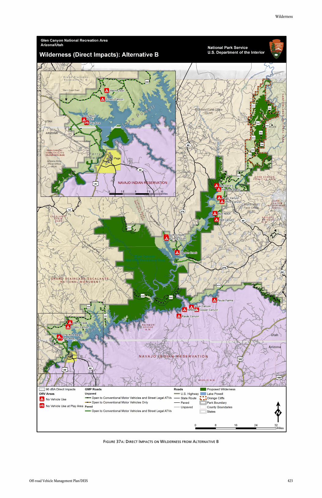
Cumulative Impacts
Under alternative B, the same past, present, and future activities within Glen Canyon have the potential to affect the quality of proposed wilderness areas as under alternative A. Overall, with and without the 96 dBA limit, 25.57% of proposed wilderness areas would be impacted by motor vehicle noise (see figure 37b). The impacts of these actions, in combination with the beneficial impacts on proposed wilderness areas under alternative B, would result in slightly negative cumulative impacts on proposed wilderness. However, the beneficial restrictions on motor vehicle use, including closure of accessible shoreline areas under alternative B would also provide cumulative benefits to proposed wilderness areas.
Chapter 4: Environmental Consequences
422 Glen Canyon National Recreation Area
Wilderness
Off-road Vehicle Management Plan/DEIS 423
FIGURE 37A: DIRECT IMPACTS ON WILDERNESS FROM ALTERNATIVE B
Chapter 4: Environmental Consequences
424 Glen Canyon National Recreation Area
Wilderness
Off-road Vehicle Management Plan/DEIS 425
FIGURE 37B: CUMULATIVE IMPACTS ON WILDERNESS FROM ALTERNATIVE B
Chapter 4: Environmental Consequences
426 Glen Canyon National Recreation Area
Wilderness
Off-road Vehicle Management Plan/DEIS 427
ALTERNATIVE C: INCREASED MOTORIZED ACCESS
Lone Rock Beach
Similar to alternative A, no impacts on proposed wilderness at Lone Rock Beach would be expected under alternative C, because there are no proposed wilderness areas at Lone Rock Beach.
Lone Rock Beach Play Area
Similar to alternative A, no impacts on wilderness at the Lone Rock Beach Play Area would be expected under alternative C, because there are no proposed wilderness areas at the Lone Rock Beach Play Area.
Accessible Shorelines
Under alternative C, adverse impacts on proposed wilderness areas adjacent to accessible shoreline areas would occur at 15 accessible shoreline areas (13 existing shoreline areas as well as Paiute Farms and Nokai Canyon) because these areas would be authorized for use by conventional motor vehicles, OHVs, and street-legal ATVs, by permit only, and subject to water-level closures. Impacts on proposed wilderness areas adjacent to accessible shorelines would occur in areas where ORV noise is audible to visitors, which would degrade the natural condition of the proposed wilderness areas (including the introduction of man-made noise), negatively impact the opportunity for visitors to experience natural quiet and solitude, and compromise the primeval and untrammeled characteristics of the proposed wilderness areas. With the 96-dBA noise limit mitigation measure, noise from ORVs is expected to travel 5,460 feet from the shoreline areas before it reaches the 20-dBA natural ambient level. Under alternative C, only the Dirty Devil, Hite Boat Ramp, Blue Notch and Red Canyon accessible shorelines would create impacts from conventional motor vehicle, OHV, and street-legal ATV use to proposed wilderness areas, because these are the only accessible shorelines that are adjacent to proposed wilderness areas that would be open to these vehicles. Further, these accessible shoreline areas generally do not experience high vehicle use. The typical usage pattern at these accessible shorelines is that vehicles drive to the shoreline and park, thus the duration of impacts short-term and impacts would be low.
Travel on GMP Roads in Glen Canyon
OHVs and street-legal ATVs would be authorized to operate on all GMP roads, including roads in the Orange Cliffs Unit. As a result, adverse impacts on proposed wilderness areas adjacent to all GMP roads would occur due to noise from these vehicles (see figure 38a). Impacts on proposed wilderness areas adjacent to GMP roads would occur in areas where OHVs and street-legal ATVs noise is audible to visitors, which would degrade the natural condition of the proposed wilderness areas (including the introduction of man-made noise), negatively impact the opportunity for visitors to experience natural quiet and solitude, and compromise the primeval and untrammeled characteristics of the proposed wilderness areas. With the 96-dBA noise limit mitigation measure, noise from OHVs and street-legal ATVs is expected to travel 5,460 feet from GMP roads before it reaches the 20-dBA natural ambient level. The impacts from vehicular use on these GMP roads would be minimal with and without the 96 dBA noise limit. However, visitors in proposed wilderness areas would likely only hear noise from OHVs and street-legal ATVs infrequently and temporarily, because the vehicles would be traveling through the area.
Ferry Swale
Under alternative C, approximately 15 miles of ORV routes would be designated and authorized for use by conventional motor vehicles, OHVs and street-legal ATVs, and proposed wilderness areas within Ferry Swale would experience detectable impacts from motor vehicle noise. There are proposed wilderness areas east and south of designated ORV routes that would be authorized for use by conventional motor vehicles, OHVs, and street-legal
Chapter 4: Environmental Consequences
428 Glen Canyon National Recreation Area
ATVs (see figure 38a). As a result, proposed wilderness areas in Ferry Swale would experience negative impacts due to the noise from these motor vehicles, which would degrade the natural condition of the proposed wilderness areas (including the introduction of man-made noise), negatively impact the opportunity for visitors to experience natural quiet and solitude, and compromise the primeval and untrammeled characteristics of the proposed wilderness areas. With the 96 dBA noise limit mitigation measure, noise from OHVs and street-legal ATVs is expected to travel 5,460 feet before it reaches the 20 dBA natural ambient level. The impacts on proposed wilderness from OHVs and street-legal ATV noise on these routes would be minimal with and without the 96 dBA noise limit.
Cumulative Impacts
Under alternative C, the same past, present, and future activities within Glen Canyon have the potential to affect the quality of proposed wilderness areas as under alternative A. Overall, without the 96 dBA limit, 30.61% of proposed wilderness areas would be impacted by motor vehicle noise, whereas 28.39% of proposed wilderness would be impacted with the 96 dBA limit (see figure 38b). The impacts of these actions, in combination with the negative impacts on proposed wilderness areas under alternative C, would result in negative cumulative impacts on proposed wilderness, as described in the “Soundscapes” section.