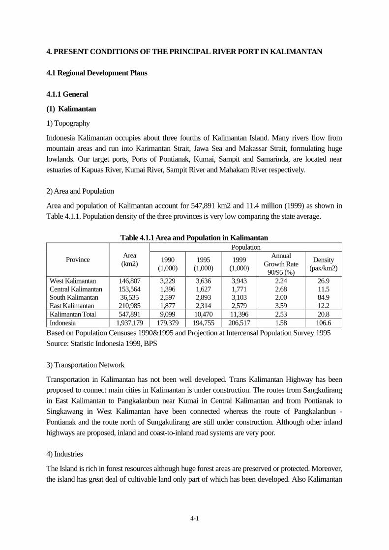
4-1 4. PRESENT CONDITIONS OF THE PRINCIPAL RIVER PORT IN KALIMANTAN 4.1 Regional Development Plans 4.1.1 General (1) Kalimantan 1) Topography Indonesia Kalimantan occupies about three fourths of Kalimantan Island. Many rivers flow from mountain areas and run into Karimantan Strait, Jawa Sea and Makassar Strait, formulating huge lowlands. Our target ports, Ports of Pontianak, Kumai, Sampit and Samarinda, are located near estuaries of Kapuas River, Kumai River, Sampit River and Mahakam River respectively. 2) Area and Population Area and population of Kalimantan account for 547,891 km2 and 11.4 million (1999) as shown in Table 4.1.1. Population density of the three provinces is very low comparing the state average. Table 4.1.1 Area and Population in Kalimantan Population Province Area (km2) 1990 (1,000) 1995 (1,000) 1999 (1,000) Annual Growth Rate 90/95 (%) Density (pax/km2) West Kalimantan Central Kalimantan South Kalimantan East Kalimantan 146,807 153,564 36,535 210,985 3,229 1,396 2,597 1,877 3,636 1,627 2,893 2,314 3,943 1,771 3,103 2,579 2.24 2.68 2.00 3.59 26.9 11.5 84.9 12.2 Kalimantan Total 547,891 9,099 10,470 11,396 2.53 20.8 Indonesia 1,937,179 179,379 194,755 206,517 1.58 106.6 Based on Population Censuses 1990&1995 and Projection at Intercensal Population Survey 1995 Source: Statistic Indonesia 1999, BPS 3) Transportation Network Transportation in Kalimantan has not been well developed. Trans Kalimantan Highway has been proposed to connect main cities in Kalimantan is under construction. The routes from Sangkulirang in East Kalimantan to Pangkalanbun near Kumai in Central Kalimantan and from Pontianak to Singkawang in West Kalimantan have been connected whereas the route of Pangkalanbun - Pontianak and the route north of Sungakulirang are still under construction. Although other inland highways are proposed, inland and coast-to-inland road systems are very poor. 4) Industries The Island is rich in forest resources although huge forest areas are preserved or protected. Moreover, the island has great deal of cultivable land only part of which has been developed. Also Kalimantan
Transcript
4-1
4. PRESENT CONDITIONS OF THE PRINCIPAL RIVER PORT IN KALIMANTAN 4.1 Regional Development Plans 4.1.1 General (1) Kalimantan 1) Topography Indonesia Kalimantan occupies about three fourths of Kalimantan Island. Many rivers flow from mountain areas and run into Karimantan Strait, Jawa Sea and Makassar Strait, formulating huge lowlands. Our target ports, Ports of Pontianak, Kumai, Sampit and Samarinda, are located near estuaries of Kapuas River, Kumai River, Sampit River and Mahakam River respectively. 2) Area and Population Area and population of Kalimantan account for 547,891 km2 and 11.4 million (1999) as shown in Table 4.1.1. Population density of the three provinces is very low comparing the state average.
Table 4.1.1 Area and Population in Kalimantan Population
Province
Area (km2) 1990
(1,000) 1995
(1,000) 1999
(1,000)
Annual Growth Rate
90/95 (%)
Density (pax/km2)
West Kalimantan Central Kalimantan South Kalimantan East Kalimantan
146,807 153,564 36,535 210,985
3,229 1,396 2,597 1,877
3,636 1,627 2,893 2,314
3,943 1,771 3,103 2,579
2.24 2.68 2.00 3.59
26.9 11.5 84.9 12.2
Kalimantan Total 547,891 9,099 10,470 11,396 2.53 20.8 Indonesia 1,937,179 179,379 194,755 206,517 1.58 106.6
Based on Population Censuses 1990&1995 and Projection at Intercensal Population Survey 1995 Source: Statistic Indonesia 1999, BPS 3) Transportation Network Transportation in Kalimantan has not been well developed. Trans Kalimantan Highway has been proposed to connect main cities in Kalimantan is under construction. The routes from Sangkulirang in East Kalimantan to Pangkalanbun near Kumai in Central Kalimantan and from Pontianak to Singkawang in West Kalimantan have been connected whereas the route of Pangkalanbun - Pontianak and the route north of Sungakulirang are still under construction. Although other inland highways are proposed, inland and coast-to-inland road systems are very poor. 4) Industries The Island is rich in forest resources although huge forest areas are preserved or protected. Moreover, the island has great deal of cultivable land only part of which has been developed. Also Kalimantan
4-2
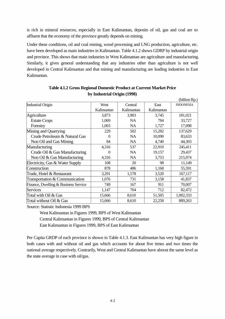
is rich in mineral resources, especially in East Kalimantan, deposits of oil, gas and coal are so affluent that the economy of the province greatly depends on mining. Under these conditions, oil and coal mining, wood processing and LNG production, agriculture, etc. have been developed as main industries in Kalimantan. Table 4.1.2 shows GDRP by industrial origin and province. This shows that main industries in West Kalimantan are agriculture and manufacturing. Similarly, it gives general understanding that any industries other than agriculture is not well developed in Central Kalimantan and that mining and manufacturing are leading industries in East Kalimantan.
Table 4.1.2 Gross Regional Domestic Product at Current Market Price by Industrial Origin (1998)
(billion Rp.) Industrial Origin West Central East INDONESIA
Kalimantan Kalimantan Kalimantan Agriculture 3,873 3,903 3,745 181,021 Estate Crops 1,069 NA 784 33,727 Forestry 1,003 NA 1,727 17,098 Mining and Quarrying 229 502 15,282 137,629 Crude Petroleum & Natural Gas 0 NA 10,090 83,633 Non Oil and Gas Mining 84 NA 4,740 44,303 Manufacturing 4,316 537 22,910 245,411 Crude Oil & Gas Manufacturing 0 NA 19,157 29,437 Non Oil & Gas Manufacturing 4,316 NA 3,753 215,974 Electricity, Gas & Water Supply 108 20 98 11,149 Construction 878 486 1,168 55,591 Trade, Hotel & Restaurant 3,291 1,578 3,520 167,117 Transportation & Communication 1,076 731 3,158 41,837 Finance, Dwelling & Business Service 749 167 911 70,007 Services 1,147 704 712 82,472 Total with Oil & Gas 15,666 8,610 51,505 1,002,333 Total without Oil & Gas 15,666 8,610 22,258 889,263 Source: Statistic Indonesia 1999 BPS West Kalimantan in Figures 1999, BPS of West Kalimantan Central Kalimantan in Figures 1999, BPS of Central Kalimantan East Kalimantan in Figures 1999, BPS of East Kalimantan Per Capita GRDP of each province is shown in Table 4.1.3. East Kalimantan has very high figure in both cases with and without oil and gas which accounts for about five times and two times the national average respectively. Contrarily, West and Central Kalimantan have almost the same level as the state average in case with oil/gas.
4-3
Table 4.1.3 Per Capita GRDP of Each Province With Without Island, Province
Oil & Gas Oil & Gas West Kalimantan 4,086 4,086 Central Kalimantan 5,107 5,107 South Kalimantan 3,941 3,892 East Kalimantan 21,525 9,034 Kalimantan Total 8,121 5,303
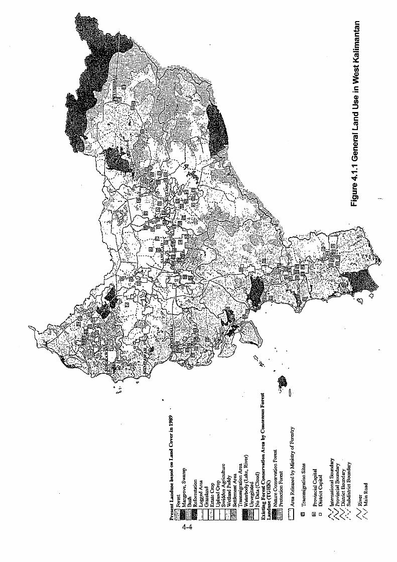
Indonesia (27 Provinces) 4,435 3,968 Source: Statistic Indonesia 1999, BPS (2) West Kalimantan West Kalimantan, where Port of Pontianak is located, occupies 146,807 Km2 and 3.9 million of population (1999), bordering on Sarawak, Malaysia and Central Kalimantan with mountains. The province has lowlands along the west coast and in the central area where Kapuas River originating the east border mountain area runs to the west and pours into Kalimantan Strait. The capital city is Pontianak with 485 thousand of population (1999). General land use in West Kalimantan is shown in Figure 4.1.1. (3) Central Kalimantan Central Kalimantan has the second largest area and the smallest population in the Island with 153,567 km2 and 1.8 million respectively, that is, the most thinly populated area. The province borders on West Kalimantan to the west, South Kalimantan to south-east and East Kalimantan to the east. Many rivers run in the low land which occupies almost south half of the territory from the north mountain areas to the south coast. Port Kumai sits near Kumai River estuary in the west end of the territory and Port of Sampit is located on the bank of Sampit River about 50 Km upstream from the estuary. The capital city is Palangkaraya, about 200 km east of Sampit, with 150 thousand of population (1999). Despite no oil/gas production, per capita GRDP with oil/gas is ranked above the national average and in case without oil/gas, it is bigger than the national average by 28%. Relatively vast production forest is remained in Central Kalimantan. General land use in Central Kalimantan is shown in Figure 4.1.2. (4) East Kalimantan East Kalimantan occupies the largest area in the Kalimantan with 210,985 Km2 and has about 2.6 million of population. Similar to Central Kalimantan, the province is thinly populated or has only one tenth of the state average population density. Almost all the area is mountainous except the south inland and the coastal areas. Port of Samarinda is located at Samarinda city, the capital with 407 thousand of population (1999), several tens of Km upstream the Mahakam River estuary where vast
4-5
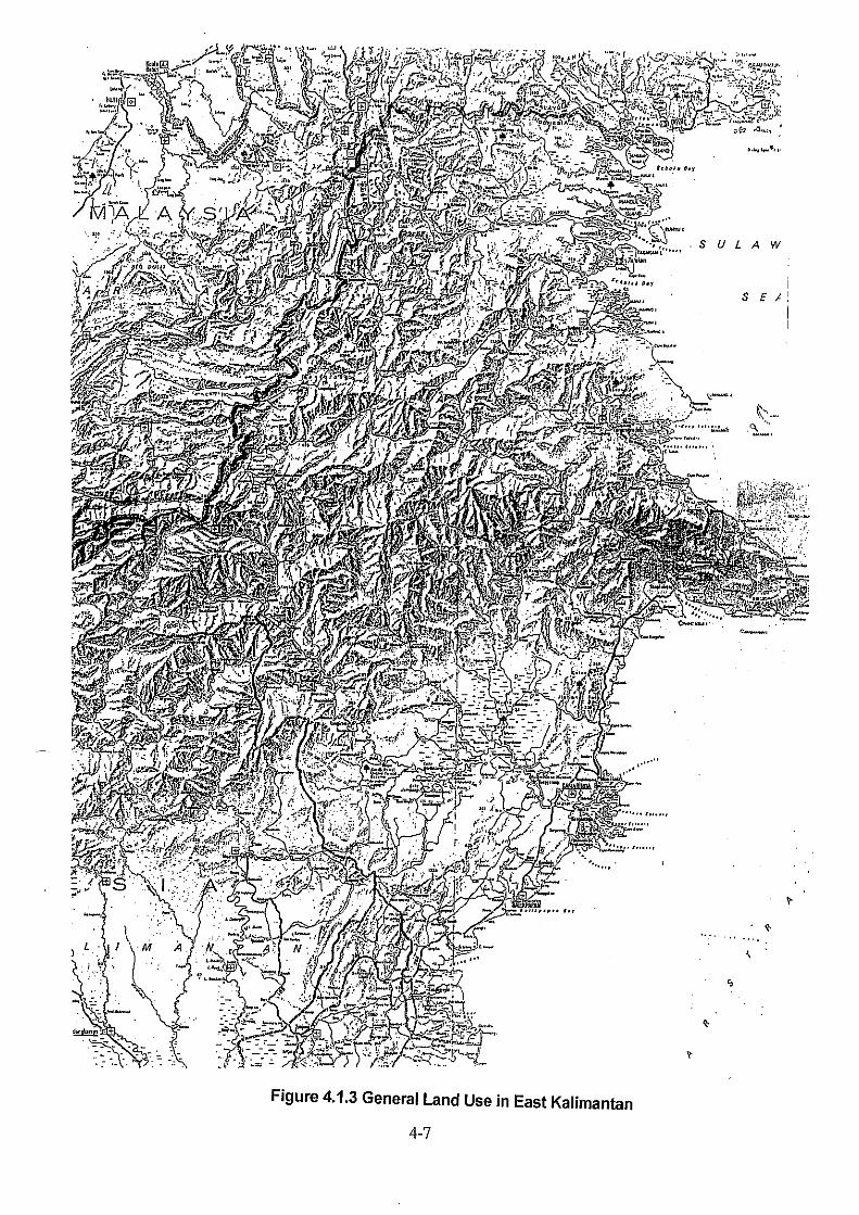
delta is formulated. East Kalimantan is rich in forest and mineral resourced, especially in gas and coal although land area suitable for agriculture is not huge. These affluent natural resources place East Kalimantan’s GRDP high rank among provinces. General land use in East Kalimantan is shown in Figure 4.1.3. 4.1.2 Agricultural, Forestry and Fishery (1) General
Except estate in West Kalimantan, agricultural development for both crops and estate has not progressed. Although difficulty in agricultural development in the province can be understood considering mountainous topography in East Kalimantan, the development level is very low as well as crop area development in Central Kalimantan.
Table 4.1.4 Agriculture Land Use in West, Central and East Kalimantan
Agriculture Land Area Land for crop Estate
Area Proportion to Area Proportion to Province
(ha) Total Area (%) (ha) Total Area (%) West Kalimantan 719,164 4.9 1,716,833 11.7 Central Kalimantan 369,920 2.4 733,177 4.8 East Kalimantan 248,924 1.2 469,809 2.2 Indonesia 11,608,194 6.0 15,016,014 7.8 Crop: Food Crops such as Padi, Maize and Cassava, Vegetables, Fruits etc. Estate: Plantation of Oil Palm, Rubber etc. Source: Statistic Indonesia 1999, BPS
Central Kalimantan and East Kalimantan have forest resource stock because the both provinces have vast production forest area accounting for 11.7% of the state total in Central and 14.1% in East respectively.
Table 4.1.5 Forestry Area in West, Central and East Kalimantan
Forestry Forest Area Province Protection Park/Reserve Production
(ha) (ha) (ha) Kalimantan Barat 2,047 1,340 1,506 Kalimantan Tengah 800 730 4,302 Kalimantan Timur 3,626 1,986 5,192 Indonesia 29,660 19,068 36,702 Based on agreed forest land use until March 1998 Source: Statistics Indonesia 1999, BPS
4-8
Fishery productions in the three provinces are shown in Table 4.1.6.
Table 4.1.6 Fishery Production in West, Central and East Kalimantan Fishery Production
Province Total Marine Inland Open Inland Culture (ton) (ton) (ton) (ton) Kalimantan Barat 83,493 69,518 10,969 3,006 Kalimantan Tengah 105,388 50,936 54,393 59 Kalimantan Timur 98,284 72,809 16,240 9,235
Indonesia 4,466,145 3,489,823 298,589 677,733 Source: Statistics Indonesia 1999, BPS (2) Plantation
Production of plantation by kind of crops is shown in Table 4.1.7. Table 4.1.7 Production of Agricultural Estates in West, Central and East Kalimantan
Year 1998 1999 1999 1999 Source: Statistics Indonesia 1999, BPS
West Kalimantan in Figures 1999, BPS of West Kalimantan Central Kalimantan in Figures 1999, BPS of Central Kalimantan East Kalimantan in Figures 1999, BPS of East Kalimantan 1) West Kalimantan
In West Kalimantan, plantation has been considerably developed, but production levels are still low except that of rubber.
2) Central Kalimantan
Agricultural development has not progressed much for plantation and crop field. Rubber production is relatively active. Central Kalimantan government has development plan of 1.7 million ha of palm oil plantation.
3) East Kalimantan
Similar to Central Kalimantan, agricultural development has not progressed much for plantation
4-9
and crop field. Palm oil production is relatively active. (2) Forestry Forestry products in the three provinces are shown in Table 4.1.8
Table 4.1.8 Wood Products in Riau, Jambi and South Sumatra
Wood Products West Kalimantan (m3)
Central Kalimantan (m3)
East Kalimantan (m3)
Indonesia (m3)
Logs (Production) 1,004,000 2,764,246 5,534,000 19,027,000 Sawn Wood NA 130,135 188,582 2,707,221 Plywood NA 186,598 1,196,552 7,154,729 Veneer NA 1,759 21,621 NA Chips NA - 13,374 NA Pulp NA - - NA Blockboard NA 302 91,329 NA Moulding/Dowel NA 84,709 59,979 NA
Year 98/99 99/00 99/00 98/99 NA: not available -: negligible Source: Statistics Indonesia 1999, BPS
West Kalimantan in Figures 1999, BPS of West Kalimantan Central Kalimantan in Figures 1999, BPS of Central Kalimantan East Kalimantan in Figures 1999, BPS of East Kalimantan
1) West Kalimantan
Forestry production area in West Kalimantan is not huge comparing with Central and East Kalimantan. Log production in the province accounts for about 5% of the state total.
2) Central Kalimantan
Although Central Kalimantan produces about 15% of logs in Indonesia, production level of value-added products remains low because the down stream processing industries such as plywood have not been established.
3) East Kalimantan
East Kalimantan produces about 30% of logs in Indonesia and about 17% of plywood. Also production levels of brockboard and moulding/dowel are relatively high. Thus, the province has established value-added industry in forestry sector to some extent.
4.1.3 Industrial Development (1) General
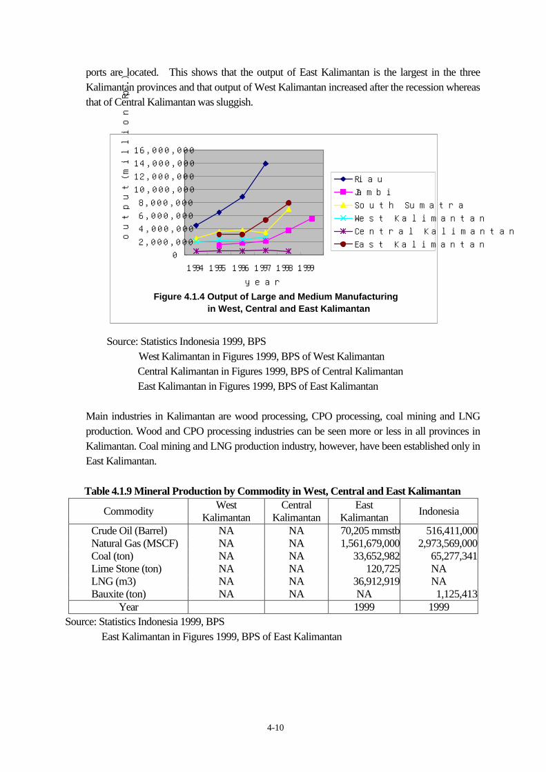
Figure 4.1.4 shows output of large/medium manufacturing in the provinces where the target
4-10
ports are located. This shows that the output of East Kalimantan is the largest in the three Kalimantan provinces and that output of West Kalimantan increased after the recession whereas that of Central Kalimantan was sluggish.
Figure 4.1.4 Output of Large and Medium Manufacturing in West, Central and East Kalimantan
02,000,0004,000,0006,000,0008,000,000
10,000,00012,000,00014,000,00016,000,000
1994 1995 1996 1997 1998 1999year
outp
ut(m
illio
n R
p.)
RiauJambiSouth SumatraWest KalimantanCentral KalimantanEast Kalimantan
Source: Statistics Indonesia 1999, BPS West Kalimantan in Figures 1999, BPS of West Kalimantan
Central Kalimantan in Figures 1999, BPS of Central Kalimantan East Kalimantan in Figures 1999, BPS of East Kalimantan
Main industries in Kalimantan are wood processing, CPO processing, coal mining and LNG production. Wood and CPO processing industries can be seen more or less in all provinces in Kalimantan. Coal mining and LNG production industry, however, have been established only in East Kalimantan.
Table 4.1.9 Mineral Production by Commodity in West, Central and East Kalimantan
Commodity West Kalimantan
Central Kalimantan
East Kalimantan Indonesia
Crude Oil (Barrel) NA NA 70,205 mmstb 516,411,000 Natural Gas (MSCF) NA NA 1,561,679,000 2,973,569,000 Coal (ton) NA NA 33,652,982 65,277,341 Lime Stone (ton) NA NA 120,725 NA LNG (m3) NA NA 36,912,919 NA Bauxite (ton) NA NA NA 1,125,413
Year 1999 1999 Source: Statistics Indonesia 1999, BPS East Kalimantan in Figures 1999, BPS of East Kalimantan
4-11
(2) Oil and Gas 1) West Kalimantan
In West Kalimantan, oil/gas is not in production. 2) Central Kalimantan
In Central, oil/gas is not in production. 3) East Kalimantan
Oil and gas mining greatly contribute to economy of East Kalimantan and supply materials for LNG production. Productions of oil and gas are 70,205 MMSTB and 1,561,679 MMSCF in 1999. Petroleum chemical industry is also active producing 74 million barrel per annum of petroleum products and 37 million M3 per annum of LNG in 1999.
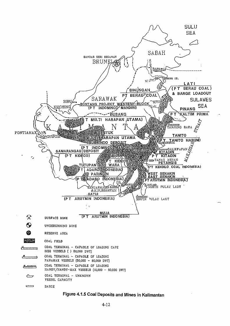
(3) Mineral Mining other than Oil and Gas Figure 4.1.5 illustrates coal deposits and mines in Kalimantan. This suggests the three provinces have a chance of development and/or expansion of coal mine. 1) West Kalimantan
Although mineral resource deposit of bauxite, coal, etc. is said to be rich, mining activity is low. 2) Central Kalimantan
Although 18 mining activities in Central Kalimantan are in the stages of general research, exploration and exploitation, production level is low.
3) East Kalimantan
Coal mining is also active producing 34 million tons in 1999 and the production increased 13.4% from the previous year.
(4) Other Industries 1) West Kalimantan
Wood sector is relatively active because of rich forestry resources. 2) Central Kalimantan
Central Kalimantan is in almost the same situation as West Kalimantan. 3) East Kalimantan
4-13
Situation of East Kalimantan is considerably different from two others. Wood output accounts for 12% of the state total and output from chemical sector is high. Production of urea, fertilizer, contributed high output of chemical sector producing 1.8 million tons and distributing to domestic (56%) and foreign destinations (44%).
4.1.4 Prospects for Industrial Development (1) Spatial Plan The special areas related to the target ports (Figure 4.1.6) and the functions are:
Pontianak Industry, Food Crops and Fishery Johar-Sanggau Industry, Estate, Forestry, Food Crops and Mining Singkawang Industry, Estate and Food Crops Kapuas Hulu Estate and Food Crops
Sampit Industry, Estate, Forestry, Food Crops and Fishery Pangkalan Bun Industry, Estate, Forestry, Food Crops and Fishery
(2) Industrial Development Plans 1) Mining Although there are no concrete plan, exploitation of big deposits of coal, bauxite etc. can be anticipated in West Kalimantan. 2) Industrial Estates
In East Kalimantan, at Kariangau (Balikpapan), an industrial estate development was once planned by using ADB loan, then canceled. The project is progressing slowly at the moment.
(3) Tendency of Industrial Development Although information about future regional development is so limited, perspective of respective regional development in each province can be organized by collecting provincial government’s future outlook and existing reports on several regional development as follows:
West Kalimantan: Forestry, Exploitation of Mineral Deposits, Palm Oil Plantation
Central Kalimantan: Palm Oil Plantation,
Forestry
4-14
East Kalimantan: Industrial Estate, Mining Plantation
4-16
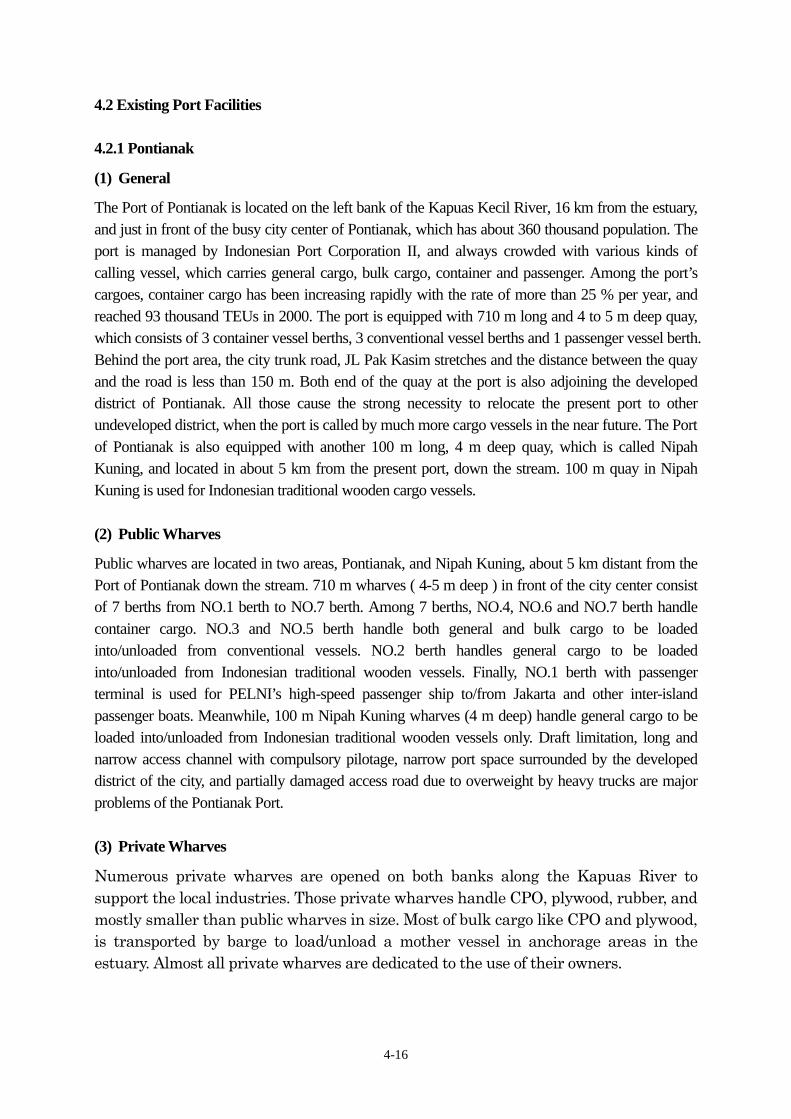
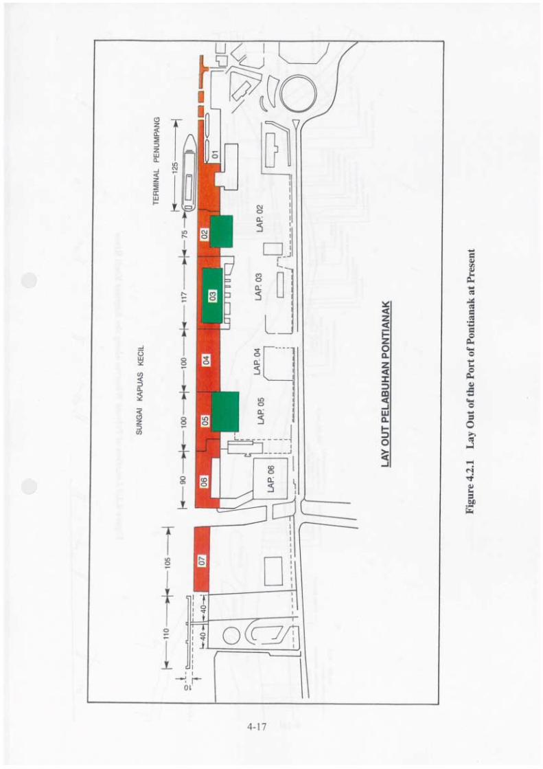
4.2 Existing Port Facilities 4.2.1 Pontianak (1) General The Port of Pontianak is located on the left bank of the Kapuas Kecil River, 16 km from the estuary, and just in front of the busy city center of Pontianak, which has about 360 thousand population. The port is managed by Indonesian Port Corporation II, and always crowded with various kinds of calling vessel, which carries general cargo, bulk cargo, container and passenger. Among the port’s cargoes, container cargo has been increasing rapidly with the rate of more than 25 % per year, and reached 93 thousand TEUs in 2000. The port is equipped with 710 m long and 4 to 5 m deep quay, which consists of 3 container vessel berths, 3 conventional vessel berths and 1 passenger vessel berth. Behind the port area, the city trunk road, JL Pak Kasim stretches and the distance between the quay and the road is less than 150 m. Both end of the quay at the port is also adjoining the developed district of Pontianak. All those cause the strong necessity to relocate the present port to other undeveloped district, when the port is called by much more cargo vessels in the near future. The Port of Pontianak is also equipped with another 100 m long, 4 m deep quay, which is called Nipah Kuning, and located in about 5 km from the present port, down the stream. 100 m quay in Nipah Kuning is used for Indonesian traditional wooden cargo vessels. (2) Public Wharves Public wharves are located in two areas, Pontianak, and Nipah Kuning, about 5 km distant from the Port of Pontianak down the stream. 710 m wharves ( 4-5 m deep ) in front of the city center consist of 7 berths from NO.1 berth to NO.7 berth. Among 7 berths, NO.4, NO.6 and NO.7 berth handle container cargo. NO.3 and NO.5 berth handle both general and bulk cargo to be loaded into/unloaded from conventional vessels. NO.2 berth handles general cargo to be loaded into/unloaded from Indonesian traditional wooden vessels. Finally, NO.1 berth with passenger terminal is used for PELNI’s high-speed passenger ship to/from Jakarta and other inter-island passenger boats. Meanwhile, 100 m Nipah Kuning wharves (4 m deep) handle general cargo to be loaded into/unloaded from Indonesian traditional wooden vessels only. Draft limitation, long and narrow access channel with compulsory pilotage, narrow port space surrounded by the developed district of the city, and partially damaged access road due to overweight by heavy trucks are major problems of the Pontianak Port. (3) Private Wharves Numerous private wharves are opened on both banks along the Kapuas River to support the local industries. Those private wharves handle CPO, plywood, rubber, and mostly smaller than public wharves in size. Most of bulk cargo like CPO and plywood, is transported by barge to load/unload a mother vessel in anchorage areas in the estuary. Almost all private wharves are dedicated to the use of their owners.
4-19
4.2.2 Kumai (1) General The Port of Kumai is located on the right bank of the Kumai River, 20 nautical miles from the estuary of the river, and just in front of the busy city center of Kumai. The port is managed by Indonesian Port Corporation III, and crowded with bulk cargo vessels and passenger boats. The port is equipped with 322 m long, 4-5 m deep, 10 m in breadth quay. Behind the port area, the city trunk road, JL. Bendahara stretches and the distance between the quay and the road is 85 m at most. Both end of the quay at the port is also adjoining the developed district of Kumai. All those caused the port to be developed in a new site along the Kumai River. The new Kumai port, which is located in Bumiharjo, 11 km up the stream, is now an early stage of construction, and the first phase of the long term project will be operational in December 2001 as the distribution center of CPO, which is produced in the port hinterland in agriculturally rich Central Kalimantan. (2) Public Wharves Public wharves are located in two areas, Kumai and Bumiharjo, 11 km up the stream of the Kumai River. 322m wharves (4-5 m deep, 10 m in breadth) in front of the Kumai city center, handle general cargo, bulk cargo, in addition to passenger. General cargo to be loaded into/unloaded from Indonesian traditional wooden vessels, is also handled at wharves at Kumai. Meanwhile, a 60 m jetty, which is now under construction, will handle CPO liquid cargo in July 2001. Draft limitation, long and narrow access channel with compulsory pilotage, narrow port space surrounded by the developed district of the city, are major problems of the Kumai Port. (3) Private Wharves Numerous private wharves are opened on both banks along the Kumai River to support the local industries. Those private wharves handle CPO, plywood, rattan, and mostly smaller than public wharves in size. Most of bulk cargo like CPO and plywood, is transported by barge to load/unload a mother vessel in anchorage areas in the estuary. Almost all private wharves are dedicated to the use of their owners.
4-20
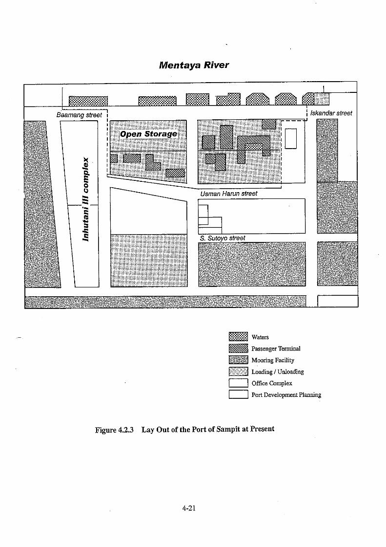
4.2.3 Sampit (1) General The Port of Sampit is located on the right bank of the Mentaya River, 34 nautical miles from the estuary of the river, and just in front of the busy city center of Sampit. The port is managed by Indonesian Port Corporation III, and always crowded with various kinds of calling vessels, which carries general cargo, bulk cargo, container cargo and passenger. Among the port’s cargoes, container cargo has been increasing rapidly year by year, and reached 12 thousand TEUs in 1999. The port is equipped with 316 m long, 5.5 m deep, 10 m in breadth wharves, which accommodate conventional, traditional, container and passenger vessels. Behind the port area, the city trunk road, Usman Harun Street stretches which restrains the setback of the port area to gain more space. Both end of quay at the port is also adjoining the developed district of Sampit. All those caused the port to be developed in a new site along the Mentaya River. The new Sampit port, which is located in Bagendang, 22 km down the stream, is now under construction, and the first phase of the long-term project will be operational in December 2001 as the distribution center of CPO, which is produced in the port hinterland in agriculturally rich Central Kalimantan. (2) Public Wharves Public wharves are located in two areas, Sampit and Bagendang, 22 km down the stream of the Mentaya River. 316 m wharves (5.5 m deep, 10 m in breadth) in front of the Sampit city center, handle container cargo, general cargo, bulk cargo, in addition to passenger. General cargo to be loaded into/unloaded from Indonesian traditional wooden vessels, is also handled at wharves at Sampit. Meanwhile a 150 m jetty, now under construction, will handle CPO liquid cargo in December 2001. Draft limitation, long and narrow access channel with compulsory pilotage, narrow port space surrounded by the developed district of the city, are major problems of the Sampit Port. (3) Private Wharves Numerous private wharves are opened on both banks along the Mentaya River to support the local industries. Those private wharves handle CPO, plywood, rattan, and mostly smaller than public wharves in size. Most of bulk cargo like CPO and plywood, is transported by barge to load/unload a mother vessel in anchorage areas in the estuary. Almost all private wharves are dedicated to the use of their owners.
4-22
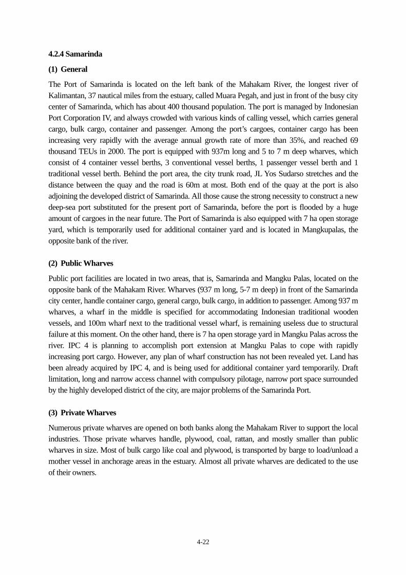
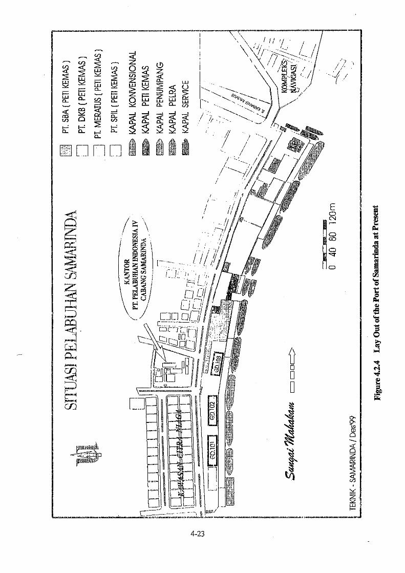
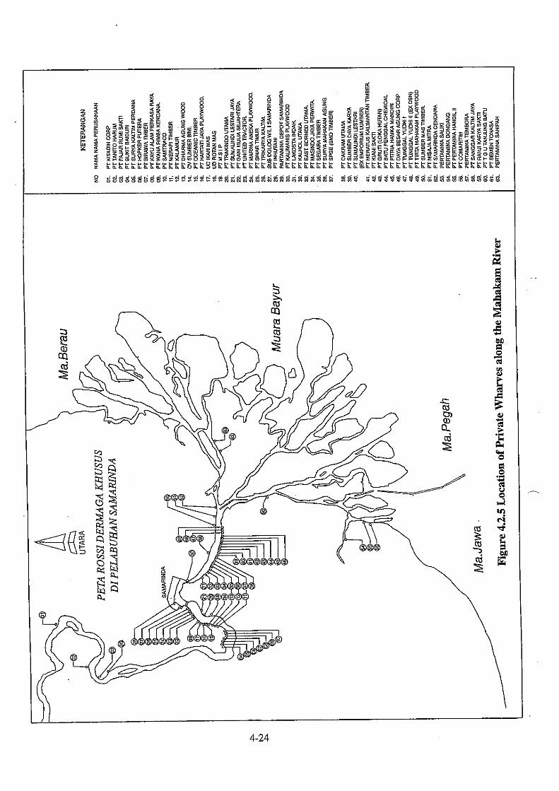
4.2.4 Samarinda (1) General The Port of Samarinda is located on the left bank of the Mahakam River, the longest river of Kalimantan, 37 nautical miles from the estuary, called Muara Pegah, and just in front of the busy city center of Samarinda, which has about 400 thousand population. The port is managed by Indonesian Port Corporation IV, and always crowded with various kinds of calling vessel, which carries general cargo, bulk cargo, container and passenger. Among the port’s cargoes, container cargo has been increasing very rapidly with the average annual growth rate of more than 35%, and reached 69 thousand TEUs in 2000. The port is equipped with 937m long and 5 to 7 m deep wharves, which consist of 4 container vessel berths, 3 conventional vessel berths, 1 passenger vessel berth and 1 traditional vessel berth. Behind the port area, the city trunk road, JL Yos Sudarso stretches and the distance between the quay and the road is 60m at most. Both end of the quay at the port is also adjoining the developed district of Samarinda. All those cause the strong necessity to construct a new deep-sea port substituted for the present port of Samarinda, before the port is flooded by a huge amount of cargoes in the near future. The Port of Samarinda is also equipped with 7 ha open storage yard, which is temporarily used for additional container yard and is located in Mangkupalas, the opposite bank of the river. (2) Public Wharves Public port facilities are located in two areas, that is, Samarinda and Mangku Palas, located on the opposite bank of the Mahakam River. Wharves (937 m long, 5-7 m deep) in front of the Samarinda city center, handle container cargo, general cargo, bulk cargo, in addition to passenger. Among 937 m wharves, a wharf in the middle is specified for accommodating Indonesian traditional wooden vessels, and 100m wharf next to the traditional vessel wharf, is remaining useless due to structural failure at this moment. On the other hand, there is 7 ha open storage yard in Mangku Palas across the river. IPC 4 is planning to accomplish port extension at Mangku Palas to cope with rapidly increasing port cargo. However, any plan of wharf construction has not been revealed yet. Land has been already acquired by IPC 4, and is being used for additional container yard temporarily. Draft limitation, long and narrow access channel with compulsory pilotage, narrow port space surrounded by the highly developed district of the city, are major problems of the Samarinda Port. (3) Private Wharves Numerous private wharves are opened on both banks along the Mahakam River to support the local industries. Those private wharves handle, plywood, coal, rattan, and mostly smaller than public wharves in size. Most of bulk cargo like coal and plywood, is transported by barge to load/unload a mother vessel in anchorage areas in the estuary. Almost all private wharves are dedicated to the use of their owners.
4-25
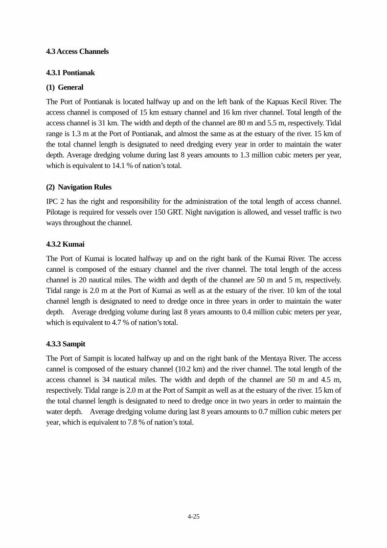
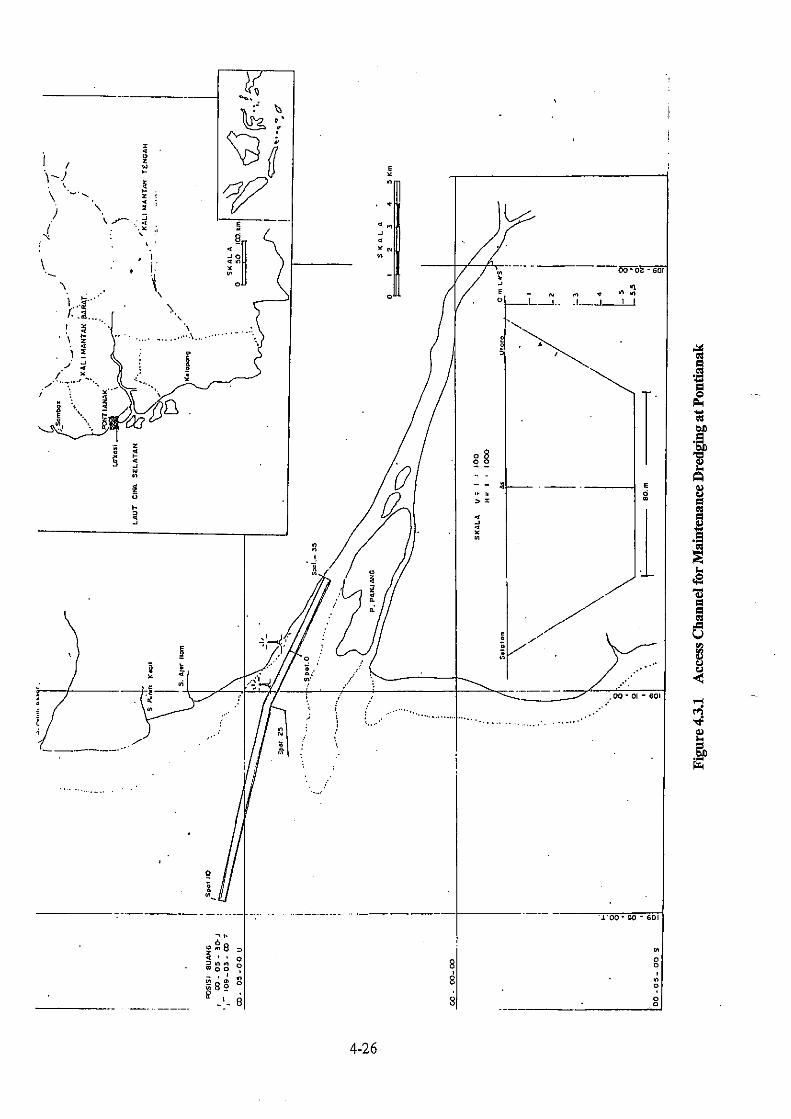
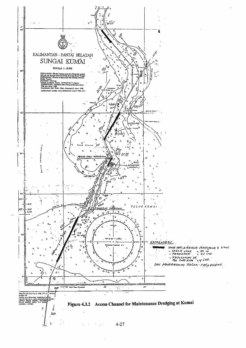
4.3 Access Channels 4.3.1 Pontianak (1) General The Port of Pontianak is located halfway up and on the left bank of the Kapuas Kecil River. The access channel is composed of 15 km estuary channel and 16 km river channel. Total length of the access channel is 31 km. The width and depth of the channel are 80 m and 5.5 m, respectively. Tidal range is 1.3 m at the Port of Pontianak, and almost the same as at the estuary of the river. 15 km of the total channel length is designated to need dredging every year in order to maintain the water depth. Average dredging volume during last 8 years amounts to 1.3 million cubic meters per year, which is equivalent to 14.1 % of nation’s total. (2) Navigation Rules IPC 2 has the right and responsibility for the administration of the total length of access channel. Pilotage is required for vessels over 150 GRT. Night navigation is allowed, and vessel traffic is two ways throughout the channel. 4.3.2 Kumai The Port of Kumai is located halfway up and on the right bank of the Kumai River. The access cannel is composed of the estuary channel and the river channel. The total length of the access channel is 20 nautical miles. The width and depth of the channel are 50 m and 5 m, respectively. Tidal range is 2.0 m at the Port of Kumai as well as at the estuary of the river. 10 km of the total channel length is designated to need to dredge once in three years in order to maintain the water depth. Average dredging volume during last 8 years amounts to 0.4 million cubic meters per year, which is equivalent to 4.7 % of nation’s total. 4.3.3 Sampit The Port of Sampit is located halfway up and on the right bank of the Mentaya River. The access cannel is composed of the estuary channel (10.2 km) and the river channel. The total length of the access channel is 34 nautical miles. The width and depth of the channel are 50 m and 4.5 m, respectively. Tidal range is 2.0 m at the Port of Sampit as well as at the estuary of the river. 15 km of the total channel length is designated to need to dredge once in two years in order to maintain the water depth. Average dredging volume during last 8 years amounts to 0.7 million cubic meters per year, which is equivalent to 7.8 % of nation’s total.
4-29
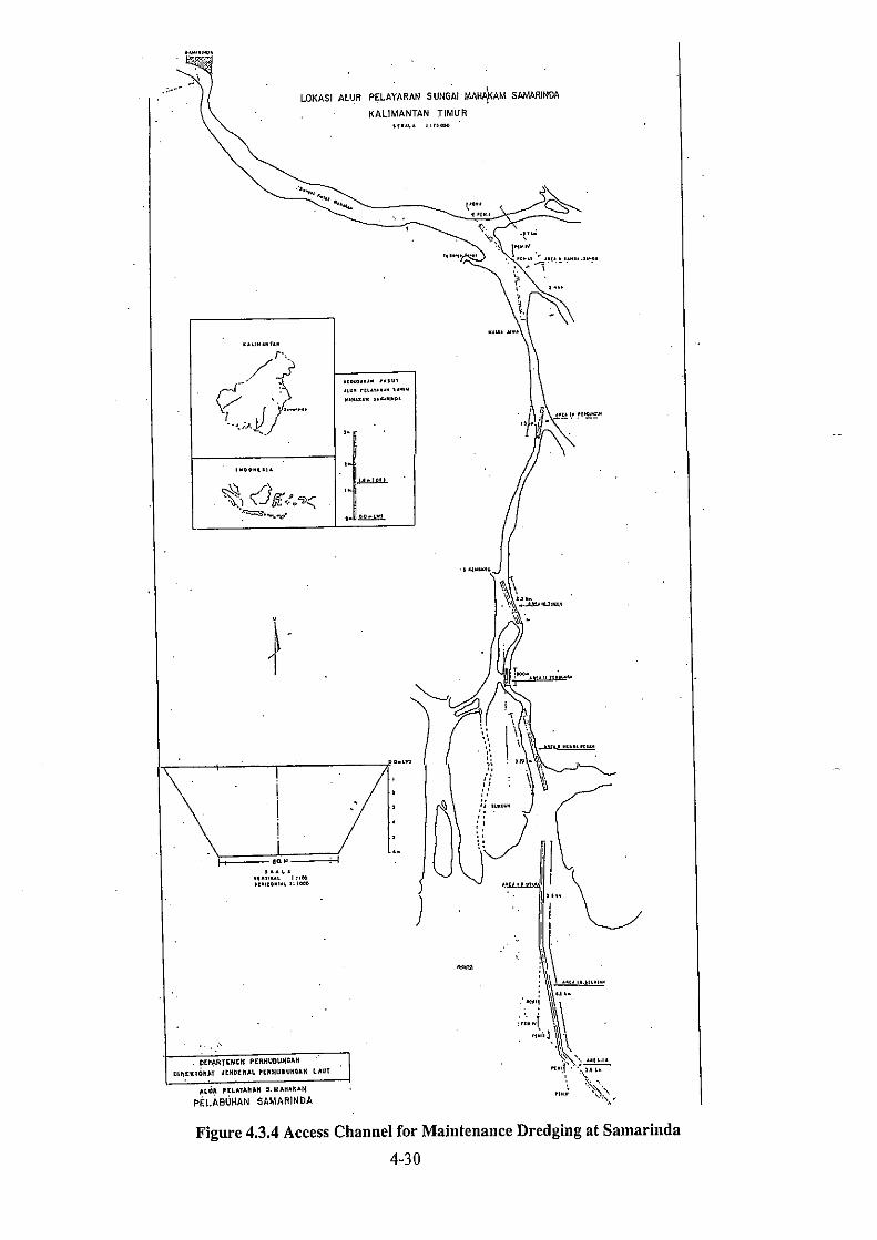
4.3.4 Samarinda (1) General The Port of Samarinda is located halfway up and on the left bank of the Mahakam River. The access cannel is composed of the estuary channel and the river channel. The total length of the access channel is 37 nautical miles. The width and depth of the channel are 70 m and 6 m, respectively. Tidal range is 1.5 m at the Port of Samarinda, and almost the same as at the estuary of the river. 24 km of the total channel length is designated to need to dredge every year in order to maintain the water depth. Average dredging volume during last 8 years amounts to 1.4 million cubic meters per year, which is equivalent to 15.6 % of nation’s total. (2) Navigation Rules IPC 4 has the right and responsibility for the administration of the access channel from the Samarinda Port to the river mouth. The Central Government has the right and responsibility for the administration of the access channel further ahead beyond the river mouth. Pilotage is required for vessels over 150 GRT. Vessels of less than 153 m length (LOA) and 6.8 m draft are allowed to enter the channel by taking advantage of high tide. Night navigation is allowed, and vessel traffic is two ways throughout the channel.