§ 404 Individual Permit Application & § 401 Water Quality Certification Stearns Road Railroad Grade Separation (PID 80729) Prepared for: Cuyahoga County Department of Public Works 2100 Superior Viaduct Cleveland, Ohio 44113 December 19, 2012
APPENDICES Appendix A. Figures Figure 1. Road Map Figure 2. USGS Topographic Map Figure 3. Terrestrial Resource Map Figure 4. Preferred Alternative Figure 5. Preferred Alternative Impacts Figure 6. Minimal Degradation Alternative Figure 7. Minimal Degradation Alternative Impacts Figure 8. Land Use Map Figure 9. Proposed Mitigation Location Map Appendix B. Agency Correspondence Appendix C. Project Plan Sheets Appendix D. Photographs Appendix E. Tables Table 1. Wetlands within the Proposed Stearns Road Grade Separation (PID 80729) Project Area Table 2. Proposed Wetland Impacts for the Proposed Stearns Road Grade Separation (PID 80729) -
Preferred Alternative Table 3. Proposed Wetland Impacts for the Proposed Stearns Road Grade Separation (PID 80729) -
Minimal Degradation Alternative Table 4. Estimated Cost of Construction by Alternative Table 5. Estimated Cost of Water Pollution Controls and Temporary Erosion Controls by Alternative
§404 Individual Permit Application
EXHIBIT 1.
Block 25. Addresses of Adjoining Property Owners
Parcel # Owner's Name House Number Street Name City Zip
264-20-024 FLETCHER,
MARGARET M.
08152 STEARNS OLMSTED
TOWNSHIP 44138
264-20-023 RAGER, JANICE
L.
08148 STEARNS OLMSTED
TOWNSHIP 44138
264-20-022 HURST, BETTY A 8140 STEARNS OLMSTED
TOWNSHIP 44138
264-20-020 TEMESVARI,
MARY K.
08086 STEARNS OLMSTED
TOWNSHIP 44138
264-20-019 VAN RIPER BETTY
J.
08068 STEARNS OLMSTED
TOWNSHIP 44138
264-20-018 MIHALIC,
RICHARD S.
08050 STEARNS OLMSTED
TOWNSHIP 44138
264-20-016 MOYSE,
GEOFFREY E.
08032 STEARNS OLMSTED
TOWNSHIP 44138
264-20-013 PEARL ROAD MINI
STORAGE INC
8000 STEARNS OLMSTED
TOWNSHIP 44138
264-21-008 KLEK BOBBIE 07949 STEARNS OLMSTED
TOWNSHIP 44138
4
§401 Water Quality Certification Application
5
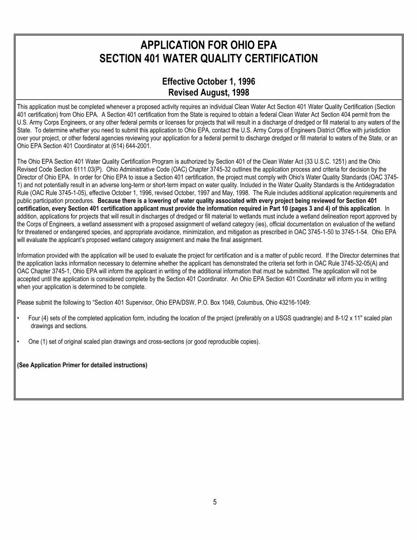
APPLICATION FOR OHIO EPA SECTION 401 WATER QUALITY CERTIFICATION Effective October 1, 1996 Revised August, 1998
This application must be completed whenever a proposed activity requires an individual Clean Water Act Section 401 Water Quality Certification (Section 401 certification) from Ohio EPA. A Section 401 certification from the State is required to obtain a federal Clean Water Act Section 404 permit from the U.S. Army Corps Engineers, or any other federal permits or licenses for projects that will result in a discharge of dredged or fill material to any waters of the State. To determine whether you need to submit this application to Ohio EPA, contact the U.S. Army Corps of Engineers District Office with jurisdiction over your project, or other federal agencies reviewing your application for a federal permit to discharge dredged or fill material to waters of the State, or an Ohio EPA Section 401 Coordinator at (614) 644-2001. The Ohio EPA Section 401 Water Quality Certification Program is authorized by Section 401 of the Clean Water Act (33 U.S.C. 1251) and the Ohio Revised Code Section 6111.03(P). Ohio Administrative Code (OAC) Chapter 3745-32 outlines the application process and criteria for decision by the Director of Ohio EPA. In order for Ohio EPA to issue a Section 401 certification, the project must comply with Ohio's Water Quality Standards (OAC 3745-1) and not potentially result in an adverse long-term or short-term impact on water quality. Included in the Water Quality Standards is the Antidegradation Rule (OAC Rule 3745-1-05), effective October 1, 1996, revised October, 1997 and May, 1998. The Rule includes additional application requirements and public participation procedures. Because there is a lowering of water quality associated with every project being reviewed for Section 401 certification, every Section 401 certification applicant must provide the information required in Part 10 (pages 3 and 4) of this application. In addition, applications for projects that will result in discharges of dredged or fill material to wetlands must include a wetland delineation report approved by the Corps of Engineers, a wetland assessment with a proposed assignment of wetland category (ies), official documentation on evaluation of the wetland for threatened or endangered species, and appropriate avoidance, minimization, and mitigation as prescribed in OAC 3745-1-50 to 3745-1-54. Ohio EPA will evaluate the applicant’s proposed wetland category assignment and make the final assignment. Information provided with the application will be used to evaluate the project for certification and is a matter of public record. If the Director determines that the application lacks information necessary to determine whether the applicant has demonstrated the criteria set forth in OAC Rule 3745-32-05(A) and OAC Chapter 3745-1, Ohio EPA will inform the applicant in writing of the additional information that must be submitted. The application will not be accepted until the application is considered complete by the Section 401 Coordinator. An Ohio EPA Section 401 Coordinator will inform you in writing when your application is determined to be complete. Please submit the following to “Section 401 Supervisor, Ohio EPA/DSW, P.O. Box 1049, Columbus, Ohio 43216-1049: • Four (4) sets of the completed application form, including the location of the project (preferably on a USGS quadrangle) and 8-1/2 x 11" scaled plan
drawings and sections. • One (1) set of original scaled plan drawings and cross-sections (or good reproducible copies).
(See Application Primer for detailed instructions)
6
1. The federal permitting agency has determined this project: (check appropriate box and fill in blanks)
a. X requires an individual 404 permit/401 certification- Corps Public Notice #__________
b. requires a Section 401 certification to be authorized by Nationwide Permit #
c. requires a modified 404 permit/401 certification for original Public Notice #
d. requires a federal permit under jurisdiction identified by #
e. requires a modified federal permit under jurisdiction identified by #
2. Application number (to be assigned by Ohio EPA):
3. Name and address of Applicant: Telephone number during business hours: Douglas L. Dillon Cuyahoga County Dept. of Public Works ( 216 ) 348-3800 (Office) 2100 Superior Viaduct Cleveland, OH 44113 ( 216 ) 348-3896 (Fax)
3a. Signature of Applicant: Date:
4. Name, address and title of Authorized Agent: Telephone number during business hours: Chantil Milam TranSystems Corp. ( 614 ) 433-7818 (Office) 1105 Schrock Road, Ste. 400 Columbus, OH 43229 ( 614 ) 846-2602 (Fax)
4a. Statement of Authorization: I hereby designate and authorize the above-named agent to act in my behalf in the processing of this permit application, and to furnish, upon request, supplemental information in support of the application.
Signature of Applicant: Date:
5. Location on land where activity exists or is proposed. Indicate coordinates of a fixed reference point at the impact site (if known) and the coordinate system and datum used.
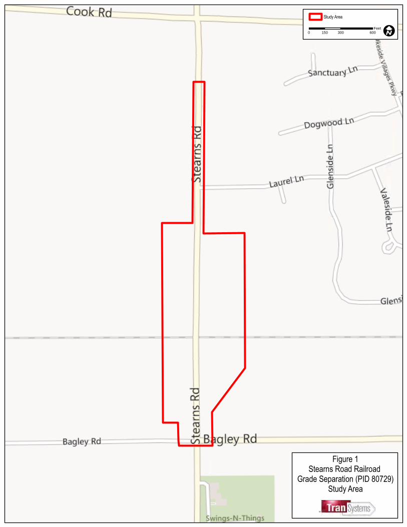
The project is located in Olmsted Township, Cuyahoga County, Ohio (Figure 1, Appendix A). The project’s southern boundary is located 900 feet south of the existing railroad crossing at the northern limit of the Bagley Road/Stearns Road intersection. The northern project boundary is located approximately 2,200 feet north of the existing railroad crossing, approximately 500 feet south of the Cook Road/Stearns Road intersection. See Exhibit 2, p.11 for a more detailed description of the project location.
Rocky River (HUC 04110001) Cuyahoga Olmsted Ohio 44138
Watershed County Township State Zip Code
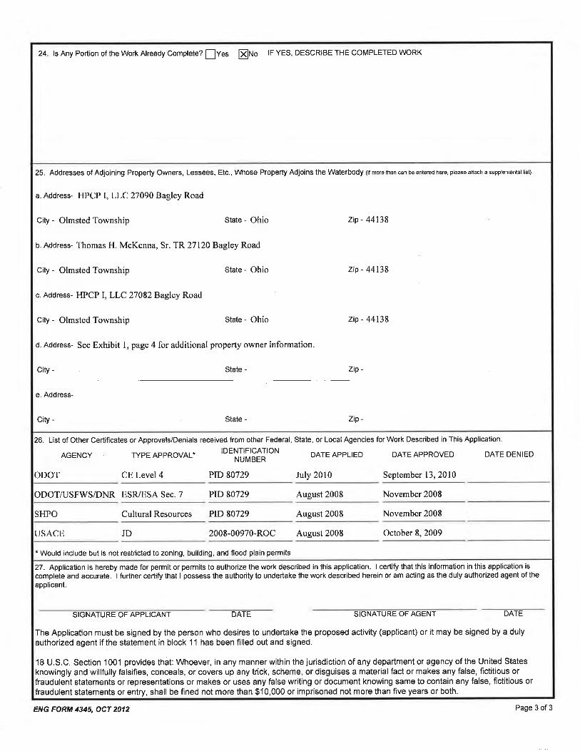
6. Is any portion of the activity for which authorization is sought complete? Yes X No If answer is "yes," give reasons, month and year activity was completed. Indicate the existing work on the drawings.
7
7. List all approvals or certifications and denials received from other federal, interstate, state or local agencies for any structures, construction, discharge or other activities described in this application.
AGENCY TYPE APPROVAL* IDENTIFICATION NUMBER DATE APPLIED DATE APPROVED DATE DENIED
ODOT Level 4 Categorical Exclusion PID 80729 July 2010 9-13-2010
ODOT Level 1 ESR PID 80729 August 2008 November
2008
USFWS / ODNR Level 1 ESR/ ESA Section 7 PID 80729 August 2008 November
2008
SHPO Cultural Resource Clearance PID 80729 August 2008 11-10-2008
8. DESCRIPTION OF THE ACTIVITY (fill in information in the following four blocks - 8a, 8b, 8c & 9)
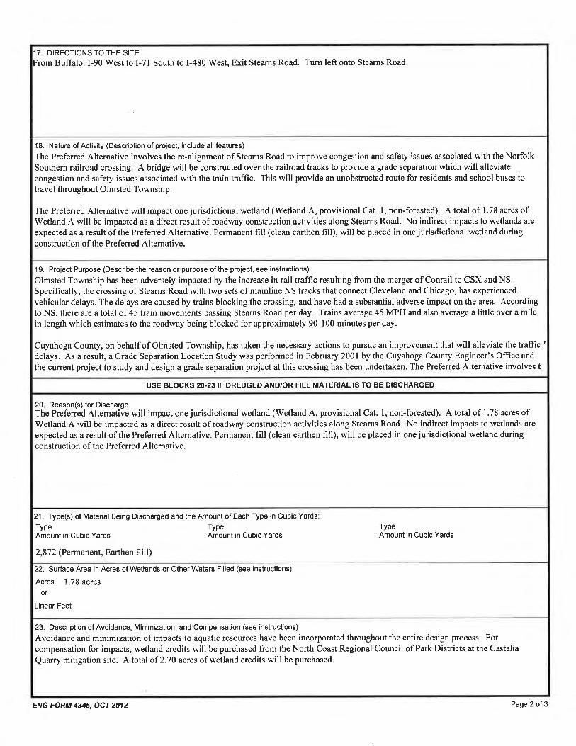
8a. Activity: Describe the Overall Activity: The Stearns Road Railroad Grade Separation project proposes to construct a railroad grade separation between Stearns Road and two Norfolk and Southern Corporation railroad tracks in Olmsted Township, Cuyahoga County, Ohio. For a more detailed description of the proposed project See Exhibit 4, p. 13. See Table 2 in Appendix E for a description of actions to one wetland impacted by the proposed project.
8b. Purpose: Describe the purpose, need and intended use of the activity: Olmsted Township has been adversely impacted by the increase in rail traffic resulting from the merger of Conrail to CSX and NS. Specifically, the crossing of Stearns Road with two sets of mainline NS tracks that connect Cleveland and Chicago, has experienced vehicular delays. The delays are caused by trains blocking the crossing, and have had a substantial adverse impact on the area. According to NS, there are a total of 45 train movements passing Stearns Road per day. Trains average 45 MPH and also average a little over a mile in length which estimates to the roadway being blocked for approximately 90-100 minutes per day. Cuyahoga County, on behalf of Olmsted Township, has taken the necessary actions to pursue an improvement that will alleviate the traffic delays. As a result, a Grade Separation Location Study was performed in February 2001 by the Cuyahoga County Engineer’s Office and the current project to study and design a grade separation project at this crossing has been undertaken. The Preferred Alternative involves the re-alignment of Stearns Road to improve congestion and safety issues associated with the Norfolk Southern railroad crossing. A bridge will be constructed over the railroad tracks to provide a grade separation which will alleviate congestion and safety issues associated with the train traffic. This will provide an unobstructed route for residents and school buses to travel throughout Olmsted Township.
8c. Discharge of dredged or fill material: Describe type, quantity of dredged material (in cubic yards), and quantity of fill material (in cubic yards). (OAC 3745-1-05(B)(2)(a)) Area Fill Volume Fill Material
Permanent (total for 1 wetland) 1.78 acres 2,872 cu.yd. Clean earthen fill Total 1.78 acres 2,872 cu.yd
9. Waterbody and location of waterbody or upland where activity exists or is proposed, or location in relation to a stream, lake, wetland, wellhead or water intake (if known). Indicate the distance to, and the name of any receiving stream, if appropriate. The Stearns Road project area is located in the Rocky River watershed (HUC 04110001), which drains to Lake Erie. One jurisdictional wetland will be impacted as a result of the proposed project. See Tables 1 and 2, Appendix E for location information and descriptions of the impacted features. (See also Exhibit 5, p. 14-15)
8
10. To address the requirements of the Antidegradation Rule, your application must include a report evaluating the:
" Preferred Design (your project) and Mitigative Techniques
" Minimal Degradation Alternative(s) (scaled-down version(s) of your project) and Mitigative Techniques
" Non-Degradation Alternative(s) (project resulting in avoidance of all waters of the state)
At a minimum, item a) below must be completed for the Preferred Design, the Minimal Degradation Alternative(s), and the Non-Degradation Alternative(s), followed by completion of item b) for each alternative, and so on, until all items have been discussed for each alternative (see Primer for specific instructions). (Application and review requirements appear at OAC 3745-1-05(B)(2), OAC 3745-1-05(C)(6), OAC 3745-1-05(C)(1) and OAC 3745-1-54).
See Exhibit 6, pp. 12-24 for an Antidegradation Rule Discussion 10a) Provide a detailed description of any construction work, fill or other structures to occur or to be placed in or near the surface water.
Identify all substances to be discharged, including the cubic yardage of dredged or fill material to be discharged to the surface water. (OAC 3745-1-05(B)(2)(b))
10b) Describe the magnitude of the proposed lowering of water quality. Include the anticipated impact of the proposed lowering of water quality on aquatic life and wildlife, including threatened and endangered species (include written comments from Ohio Department of Natural Resources and U.S. Fish and Wildlife Service), important commercial or recreational sport fish species, other individual species, and the overall aquatic community structure and function. Include a Corps of Engineers approved wetland delineation. (OAC 3745-1-05(C)(6)(a, b) and OAC 3745-1-54)
10c) Include a discussion of the technical feasibility, cost effectiveness, and availability. In addition, the reliability of each alternative shall be addressed (including potential recurring operational and maintenance difficulties that could lead to increased surface water degradation.) (OAC 3745-1-05(C)(6)(h, j-k) and OAC 3745-1-54)
10d) For regional sewage collection and treatment facilities, include a discussion of the technical feasibility, cost effectiveness and availability, and
long-range plans outlined in state or local water quality management planning documents and applicable facility planning documents. (OAC 3745-1-05(C)(6)(I))
10e) To the extent that information is available, list and describe any government and/or privately sponsored conservation projects that exist or
may have been formed to specifically target improvement of water quality or enhancement of recreational opportunities on the affected water resource. (OAC 3745-1-05(B)(2)(g))
10f) Provide an outline of the costs of water pollution controls associated with the proposed activity. This may include the cost of best
management practices to be used during construction and operation of the project. (OAC 3745-01-05(C)(6)(g))
10g) Describe any impacts on human health and the overall quality and value of the water resource. (OAC 3745-1-05(C)(6)(c) and OAC 3745-1-54)
10h) Describe and provide an estimate of the important social and economic benefits to be realized through this project. Include the number and
types of jobs created and tax revenues generated and a brief discussion on the condition of the local economy. (OAC 3745-1-5(B)(2)(e), and OAC 3745-1-05(C)(6)(I))
10i) Describe and provide an estimate of the important social and economic benefits that may be lost as a result of this project. Include the effect
on commercial and recreational use of the water resource, including effects of lower water quality on recreation, tourism, aesthetics, or other use and enjoyment by humans. (OAC 3745-1-05(B)(2)(e,f), and OAC 3745-1-05(C)(6)(e))
10j) Describe environmental benefits, including water quality, lost and gained as a result of this project. Include the effects on the aquatic life,
wildlife, threatened or endangered species. (OAC 3745-1-05 (B)(2)(e,f), OAC 3745-1-05 (C)(6)(b) and OAC 3745-1-54)
10k) Describe mitigation techniques proposed (except for the Non-Degradation Alternative):
" Describe proposed Wetland Mitigation (see OAC 3745-1-54 and Primer) " Describe proposed Stream, Lake, Pond Mitigation (see Primer)
9
11. Application is hereby made for a Section 401 Water Quality Certification. I certify that I am familiar with the information contained in this application and, to the best of my knowledge and belief, such information is true, complete and accurate. I further certify that I possess the authority to undertake the proposed activities or I am acting as the duly authorized agent of the applicant.
Signature of Applicant Date Signature of Agent Date
The application must be signed by the person who desires to undertake the proposed activity (applicant) or it may be signed by a duly authorized agent if the statement in Block 3 has been filled out and signed.
Do not send a certification processing fee with this application. The appropriate fee will be assessed when a certification is issued.
EXHIBIT 2 401 APPLICATION: BLOCK 5 Location on land where activity exists or is proposed. Indicate coordinates of a fixed reference point at the impact site (if known) and the coordinate system and datum used. The project is located in Olmsted Township, Cuyahoga County, Ohio (Figure 1, Appendix A). The project’s southern boundary is located 900 feet south of the existing railroad crossing at the northern limit of the Bagley Road/Stearns Road intersection. The northern project boundary is located approximately 2,200 feet north of the existing railroad crossing, approximately 500 feet south of the Cook Road/Stearns Road intersection. Based on the USGS North Olmsted and West View, Ohio Quadrangles (USGS,1994), the project is located at an approximate elevation of 789 feet within a residential area, located near the Lorain County border at 41°22’31.20” N latitude and -81°56’39.30”W longitude (Figure 2, Appendix A).
EXHIBIT 3 401 APPLICATION: BLOCK 7 List all approvals or certifications and denials received from other federal, interstate, state or local agencies for any structures, construction, discharge or other activities described in this application. This document serves as both the Ohio Environmental Protection Agency (Ohio EPA) Individual §401 Water Quality Certification application and the U.S. Army Corps of Engineers (USACE) §404 Individual permit application. Please refer to the table located in Block 7 of the 401 Application for a list of approvals or certifications for this proposed project. A Categorical Exclusion Document Level IV has been approved by the Ohio Department of Transportation (ODOT) (Appendix B). Coordination with the Ohio EPA, ODOT, the Ohio Department of Natural Resources (ODNR), the State Historic Preservation Office (SHPO), the U.S Fish and Wildlife Service (USFWS), and the U.S. Army Corps of Engineers (USACE) has been completed (Appendix B).
EXHIBIT 4 401 APPLICATION: BLOCK 8a Nature of activity. Description of the project. The proposed project involves a railroad grade separation between Stearns Road (C.R. 76) and two railroad tracks of Norfolk Southern Corporation railroad in Olmsted Township, Cuyahoga County, Ohio (Figure 1, Appendix A). Within the township, Stearns Road is a north-south minor arterial roadway and the project area can be described as level terrain having residential/commercial land use with developed/disturbed terrestrial habitat. Project plan sheets are provided in Appendix C. In July 1998, the Surface Transportation Board (STB) approved the acquisition of all holdings and facilities of the Consolidated Rail Corporation (Conrail) jointly by the Norfolk Southern Corporation (NS) and CSX Transportation, Inc. (CSX). The Conrail assets were divided jointly between the two rail carriers resulting in the merger of three Class I railroads into two. The proposed railroad grade separation was initiated by the Cuyahoga County Engineer’s Office upon completion of a Grade Separation Location Study which was undertaken as a result of the changes to rail traffic patterns leading to increased train traffic volumes through the western suburbs of Cuyahoga County. This increased rail volume impacts vehicular traffic by increasing accident potential, increasing vehicular traffic delays, increasing response times for emergency services, and adversely affecting school bus routes. Further, the community is affected by the increase in noise from the train horns and the decrease in air quality from idling vehicles stopped at the crossings.
The Preferred Alternative proposes a new roadway alignment approximately 225 feet east of the existing Stearns Road centerline. The overpass will be supported on earthen embankments with a three-span pre-stressed concrete I-beam structure with composite concrete deck superstructure on semi-integral stub type abutments in HP piles with spill through slopes spanning the rail lines. Piers would be located within the railroad right of way. Three frontage roads are proposed to maintain access to the properties on the north side of the tracks and the properties on the west side of the road south of the railroad tracks. Although touchdown points of the grade separation are within 1,000 feet of the existing crossing, road improvements will extend to the north to the southern project limit of the Cook Road/Stearns Road improvement project to result in a completely improved road corridor to Bagley Road. Other improvements that are proposed with this alternative include the extension of sanitary sewer trunk lines. A 15” line will be extended along Stearns Road and the western frontage road with a branch serving the properties that are along the eastern frontage road. The 18” sewer extension from Bagley Road will extend north 30 feet shy of the rail right of way where it will be stubbed to the west. A casing pipe will be installed beneath the grade separation embankment to accommodate the future extension of the line to serve the area. Other utility impacts include the relocation of the water main located along the western edge of pavement. The line will require relocation in advance of the elevated profile grade to limit the depth of cover over the pipe. New waterlines will be constructed along both frontage roads. Private utility relocations will also be required. The gas line, located along the eastern edge of pavement will require some relocation to minimize depth of cover and several utility poles and aerial lines will require relocation due to the changes in vertical and horizontal alignment. Property impacts associated with this alternative include 11 residential relocations and two total property takes as well as the acquisition of 3.3 acres of vacant commercial land. Permanent property impacts for embankment construction will be experienced where the roadway profile is elevated and temporary property impacts will be experienced along the entire corridor for grading and driveway replacements and to facilitate maintenance of traffic. The project will largely be constructed utilizing part-width construction along the length of the corridor. Local traffic will be maintained during the construction of each phase of this alternative. One-way thru traffic will be maintained in the southbound direction with northbound traffic detoured during several phases of the work when two-way traffic is not possible.
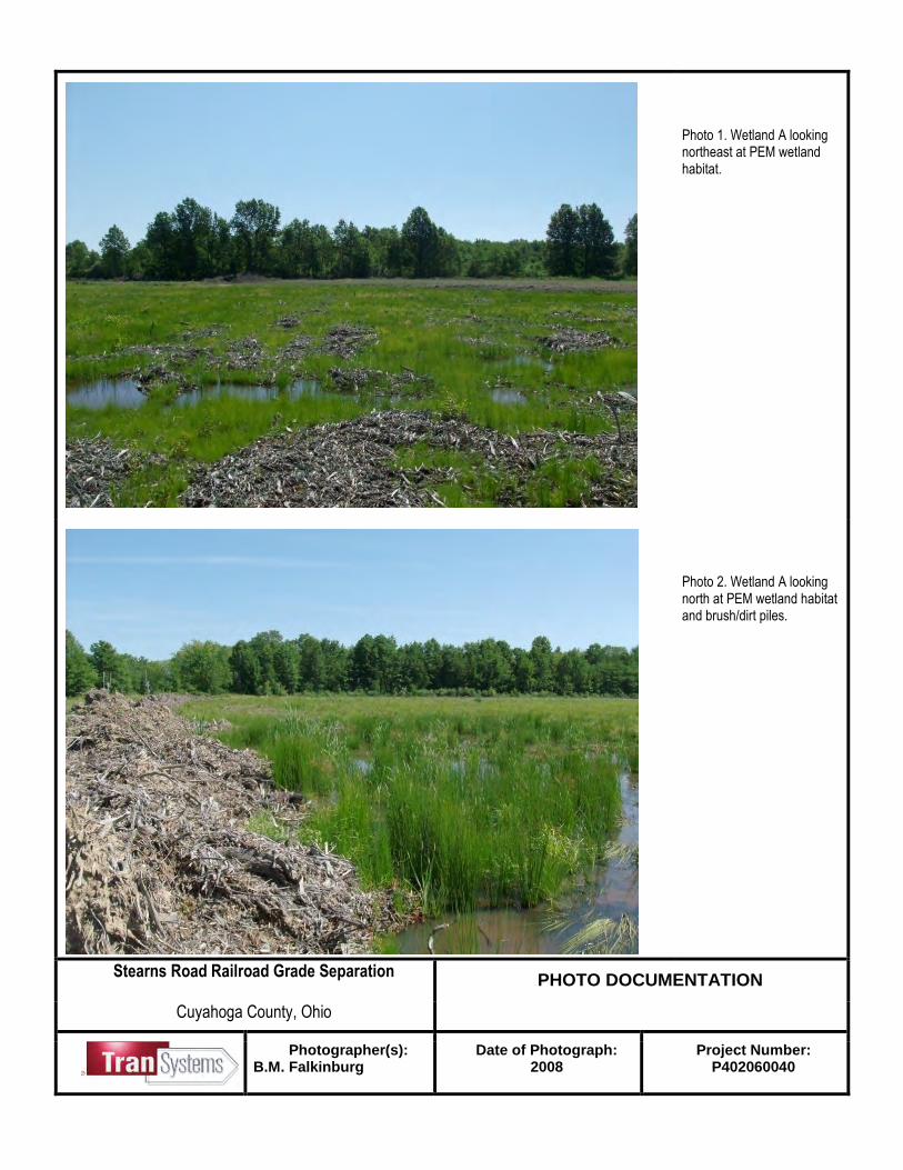
EXHIBIT 5 401 APPLICATION: BLOCK 9 Waterbody and location of waterbody or upland where activity exists or is proposed, or location in relation to a stream, lake, wetland, wellhead or water intake (if known). Indicate the distance to, and the name of any receiving stream, if appropriate. The project area is located within the West Branch Rocky River (headwaters to Rocky River) (HUC 04110001-060) of the Rocky River drainage basin (NRCS, 2012). The majority of the West Branch Rocky River (70%) was in full attainment of the existing warmwater habitat (WWH) aquatic life use; the remainder partially met the designated use (Ohio EPA, 2008b). Water quality sampling indicates a shift in impact type from nutrient enrichment from point sources to impacts associated with urban land use. West Branch Rocky River from Plum Creek to East Branch Rocky River is listed on the 303(d) List of Prioritized Impaired Waters (Category 5) (Ohio EPA, 2004). Aquatic life use, recreation use (primary contact), and fish consumption are listed as impaired. Probable impairment causes are unknown toxicity unknown ammonia, nutrients, siltation, organic enrichment/DO, and other habitat alterations. Probable sources include municipal point source, land development/suburbanization, urban runoff/storm sewers (NPS), and unknown source (Ohio EPA, 2004). Drainage of the study area occurs by way of roadside and railroad ditches as well as an unnamed tributary to the West Branch Rocky River (HUC 04110001-060). The unnamed tributary has no assigned aquatic life use designation. See Appendix B for the Jurisdictional Determination for the project area. Wetland A: Wetland A is a PEM wetland located in the southeast section of the project area (Figure 3, Appendix A and photographs in Appendix D). This PEM wetland area was delineated as 2.86 acres within the study area boundary but appears to extend outside of boundary limits for a total size of approximately 3.43 acres. Based on aerial photography and existing woody remnants on site, this wetland appears to have been cleared of woody vegetation. Furthermore, the area was being drained by means of ditching from the wetland area. This wetland scored an 18.5 on the ORAM, which indicates a provisional Category 1 wetland. Wetland A was determined to be adjacent to an off-site perennial RPW and found to present significant nexus to the Rocky River, a TNW (see USACE letter, 2008). See Table 1 in Appendix E for location information and a description of the impacted feature.
401 APPLICATION: BLOCK 10 At a minimum, item a) below must be completed for the Preferred Design, the Minimal Degradation Alternative(s), and the Non-Degradation Alternative(s), followed by completion of item b) for each alternative, and so on, until all items have been discussed for each alternative (see Primer for specific instructions). (Application and review requirements appear at OAC 3745-1-05(B)(2), OAC 3745-1-05(C)(6), OAC 3745-1-05(C)(1) and OAC 3745-1-54). Project History and Previous Studies Olmsted Township has been adversely impacted by the increase in rail traffic resulting from the merger of Conrail to CSX and NS. Specifically, the crossing of Stearns Road with two sets of mainline NS tracks that connect Cleveland and Chicago, has experienced vehicular delays. The delays are caused by trains blocking the crossing, and have had a substantial adverse impact on the area. According to NS, there are a total of 45 train movements passing Stearns Road per day. Trains average 45 MPH and also average a little over a mile in length. It has been estimated that Stearns Road is blocked by trains approximately 90-100 minutes per day. Cuyahoga County, on behalf of Olmsted Township, has taken the necessary actions to pursue an improvement that will alleviate the traffic delays. As a result, a Grade Separation Location Study was performed in February 2001 by the Cuyahoga County Engineer’s Office and the current project to study and design a grade separation project at this crossing has been undertaken. Background Information Stearns Road (C.R. 76) is classified as a Minor Urban Arterial with a posted speed limit of 35 miles per hour within the project area. It is a two-lane shouldered section with unlimited access and roadside ditches. Within the project limits, the current average daily traffic is 11,610 vehicles per day (2007) which is comprised of 3% trucks. Rail traffic averages 45 trains per day with freight trains travelling through this area at 50 miles per hour. The crossing consists of two sets of tracks that travel east-west through the middle of Olmsted Township. Trains utilizing the tracks are evenly distributed throughout the day. The warning devices at this crossing include standard railroad cross bucks and gates with mast mounted lights. Roadway improvement projects to Bagley Road and Cook Road (with some minor resurfacing of Stearns Road as it approaches the crossing) are either completed or under construction at this time, but will be completed prior to the construction of this project, so there are no other projects that would be affected by this improvement. Project Location The rail line bisects Olmstead Township north/south. The existing crossing is located on Stearns Road approximately 850 feet north of Bagley Road and 3,000 feet south of Cook Road in an area predominantly comprised of residential and commercial land use. Laurel Lane, which provides access to a residential subdivision, intersects Stearns Road to the east approximately 1,400 feet north of the railroad crossing. The area north of the railroad crossing is mostly residential land use with homes having driveway access from Stearns Road. The area south of the railroad crossing is zoned commercial, even though the current land use is residential with homes also having driveway access from Stearns Road. A large vacant property is located in the southeast quadrant of the crossing. There are two other north-south roadway corridors that parallel Stearns Road provide traffic access between Bagley Road and Cook Road. Bronson Road is located 1.2 miles west of Stearns Road and Fitch Road is located approximately one mile east of Stearns Road. A railroad grade separation is also proposed at the Fitch Road crossing but is not a part of this project.
As part of the environmental review process, several location alternatives were selected to meet the purpose and need of this proposed project. Throughout ODOT’s Project Development Process (which included several public involvement meetings), many of these conceptual alternatives were dismissed. Ultimately, two alternatives (Alternatives W-1b, E-1 and E-2) were selected as feasible alternatives. Finally, Alternative E-2 was selected as the Preferred Alternative for the proposed project. The No-Build Alternative was not considered as a conceptual alternative because it did not meet the purpose and need for the project. 10a. ALTERNATIVES DISCUSSION
Provide a detailed description of any construction work, fill or other structures to occur or to be placed in or near the surface water. Identify all substances to be discharged, including the cubic yardage of dredged or fill material to be discharged to the surface water. (OAC 3745-1-05(B)(2)(b))
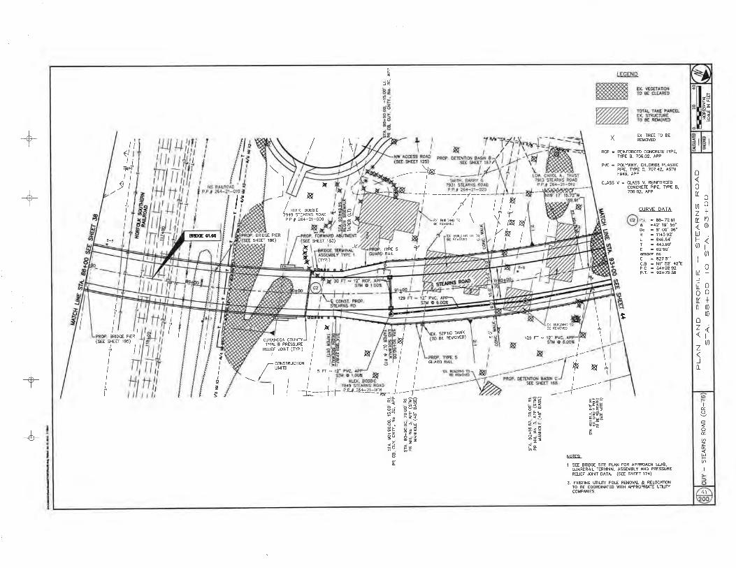
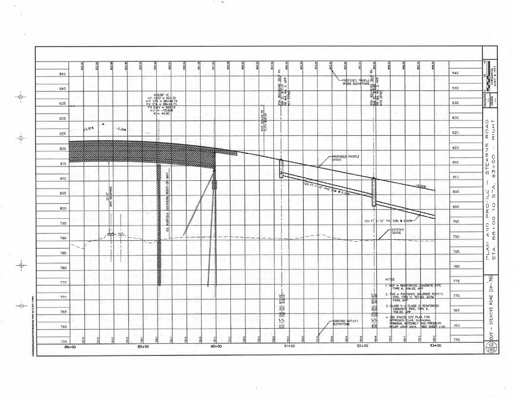
10a-1. Preferred Alternative The Preferred Alternative involves the re-alignment of Stearns Road to improve congestion and safety issues associated with the Norfolk Southern railroad crossing. A bridge will be constructed over the railroad tracks to provide a grade separation which will alleviate congestion and safety issues associated with the train traffic. This will provide an unobstructed route for residents and school buses to travel throughout Olmsted Township. The Preferred Alternative proposes a new roadway alignment approximately 225 feet east of the existing Stearns Road centerline. The overpass will be supported on earthen embankments with a three-span pre-stressed concrete I-beam structure with composite concrete deck superstructure on semi-integral stub type abutments in HP piles with spill through slopes spanning the rail lines. Piers would be located within the railroad right of way. Three frontage roads are proposed to maintain access to the properties on the north side of the tracks and the properties on the west side of the road south of the railroad tracks. Although touchdown points of the grade separation are within 1,000 feet of the existing crossing, road improvements will extend to the north to the southern project limit of the Cook Road/Stearns Road improvement project to result in a completely improved road corridor to Bagley Road. Other improvements that are proposed with this alternative include the extension of sanitary sewer trunk lines. A 15” line will be extended along Stearns Road and the western frontage road with a branch serving the properties that are along the eastern frontage road. The 18” sewer extension from Bagley Road will extend north 30 feet shy of the rail right of way where it will be stubbed to the west. A casing pipe will be installed beneath the grade separation embankment to accommodate the future extension of the line to serve the area. Other utility impacts include the relocation of the water main located along the western edge of pavement. The line will require relocation in advance of the elevated profile grade to limit the depth of cover over the pipe. New waterlines will be constructed along both frontage roads. Private utility relocations will also be required. Project plan sheets are located in Appendix C. Wetlands The Preferred Alternative will impact one jurisdictional wetland (Wetland A). A total of 1.78 acres of jurisdictional wetlands will be impacted as a direct result of roadway construction activities along Stearns Road. No indirect impacts to wetlands are expected as a result of the Preferred Alternative. Permanent fill will be placed in one jurisdictional wetland during construction of the Preferred Alternative. Fill material will consist of clean earthen fill and will be obtained by the general contractor. Proposed wetland impacts will consist of 1.78 acres of Category 1 Non-Forested wetlands.
Impacts to wetlands as a result of the Preferred Alternative are shown on Figure 5 and on attached plan sheets located in Appendix C. A summary of proposed activities and fill types and quantities for each impacted feature are shown in Table 2, Appendix E.
10a-2. Minimal Degradation Alternative The Minimal Degradation Alternative proposes the same bridge and roadway improvements as the Preferred Alternative with the exception of the embankment construction proposed for the southeast approach. In lieu of a graded embankment, a retaining wall is proposed to reduce the project footprint. Right of Way impacts are the same except for the acreage of vacant commercial land in the southeast quadrant, which for this alternative, is reduced by 0.60 acres to 2.7 acres. Other design aspects of this alternative, including the length of the roadway improvements, drainage, sanitary sewer, bridge and maintenance of traffic schemes, are identical to the Preferred Alternative. The Minimal Degradation Alternative would minimize impacts Wetland A because the proposed alignment would also include a retaining wall. The retaining wall would decrease the overall footprint of the roadway because it limits the amount of grading necessary for the construction of the roadway. The Minimal Degradation Alternative has been developed through ODOT’s PDP. Conceptual design indicates that while construction of this alternative is technically possible, it only provides marginal ecological benefit by providing less water quality impacts (Figures 6 and 7, Appendix A). Wetlands The Minimal Degradation Alternative will impact one jurisdictional wetland (Wetland A). A total of 1.30 acres of jurisdictional wetlands will be impacted as a direct result of roadway construction activities along Stearns Road. No indirect impacts to wetlands are expected as a result of the Preferred Alternative. Permanent fill will be placed in one jurisdictional wetland during construction of the Preferred Alternative. Fill material will consist of clean earthen fill and will be obtained by the general contractor. Proposed wetland impacts will consist of 1.30 acres of Category 1 Non-Forested wetlands.
Impacts to wetlands as a result of the Minimal Degradation Alternative are shown on Figure 7 and on attached plan sheets located in Appendix C. A summary of proposed activities and fill types and quantities for each impacted feature are shown in Table 3, Appendix E. 10a-3. Non-Degradation Alternative Due to the location and configuration of the project area coupled with ODOT’s design criteria for roadway widths and bridges, this proposed project cannot be completed without impacts to the aquatic resources. Therefore, the “No-Build” alternative is presented as the Non-Degradation Alternative. As the name implies, this involves not constructing the proposed improvement project. While no impacts to the resources would occur, the “No-Build” alternative does not meet the purpose and need for the project. 10b. IMPACTS ON WATER QUALITY AND AQUATIC LIFE BY ALTERNATIVE
Describe the magnitude of the proposed lowering of water quality. Include the anticipated impact of the proposed lowering of water quality on aquatic life and wildlife, including threatened and endangered species (include written comments from Ohio Department of Natural Resources and U.S. Fish and Wildlife Service), important commercial or recreational sport fish species, other individual species, and the overall aquatic community structure and function. Include a Corps of Engineers approved wetland delineation. (OAC 3745-1-05(C)(6)(a, b) and OAC 3745-1-54)
Minimal impacts on water quality, aquatic life, and wildlife species can be expected from both the Preferred and Minimal Degradation Alternatives. Field investigations did not reveal the presence of any federal or state-listed threatened, endangered, or special interest species within the study area. The Ohio Department of Natural Resources (ODNR) Division of Wildlife (DOW) was contacted for records of occurrences of endangered, threatened, or potentially threatened species and geological features within the study area, including a one mile radius. In addition, records for
Indiana bat capture locations and/or hibernacula within five miles and ten miles respectively of the study area were requested (Appendix B). This proposed project was also coordinated with ODNR Division of Wildlife and ODNR Division of Soil and Water Conservation, as well as the U.S. Fish and Wildlife Service (USFWS) (Appendix B). Coordination with ODNR and USFWS disclosed no known occurrences of any listed species, or their critical habitat within the study area. Additionally no records of Indiana bat captures or hibernacula within five and ten miles of the study area respectively were indicated. The USFWS lists four federally threatened, endangered, proposed, candidate species, and/or species of concern for Cuyahoga County, Ohio. The list includes the endangered Indiana bat (Myotis sodalis), Kirtland’s warbler (Dendroica kirtlandii) and piping plover (Charadrius melodus) (USFWS, 2012). Suitable habitat was evaluated for these species as well as suitable bald eagle (Haliaeetus leucocephalus) nesting habitat and nearest nesting sites. Federal and State-listed species and potential habitat within proximity to the Preferred Alternative are also listed in the Level 1 ESR (TranSystems, 2008). A total of 5 potential Indiana bat roosting trees would be impacted as a result of the Preferred and Minimal Degradation Alternatives. Coordination was initiated by TranSystems on November 15, 2007. A response was received from ODNR DNAP on November 20, 2007. In their comments they stated that ODNR has no record of Indiana bat (Myotis sodalist, state endangered, federal endangered) capture locations or hibernacula within a ten mile radius of the project site. There are no existing or proposed state nature preserves or scenic rivers located at the project site. They are also unaware of any unique ecological sites, geologic features, animal assemblages, scenic rivers, state parks, state forests or state wildlife areas within the project area. Coordination was initiated by ODOT-OES on October 27, 2008. Comments were received from the USFWS on December 8, 2008. In their response, the USFWS stated that the project falls under the Programmatic Consultation between the USFWS, FHWA and ODOT. The USFWS concurred with the ODOT determination that the project, as proposed, may affect, but is not likely to adversely affect the Indiana bat (Myotis sodalist). The project is within the PC-1a category of project impacts; therefore, cutting date restrictions apply. The USFWS encourages the use of the revised guidelines of tree removal prior to April 1 or after September 30. This recommendation is included as an environmental commitment to the project. The USFWS correspondence is included in Appendix B. A Jurisdictional Determination for the proposed project was received on October 8, 2009 from the USACE (Appendix B). Two wetlands (Wetland A and B) and one stream (Stream 1) were confirmed to be jurisdictional. Of those identified resources, only one wetland (Wetland A) is located within the proposed project area and will be impacted as a result of the proposed project. One wetland is considered a Category 1 wetland as determined by the Ohio Rapid Assessment Method (ORAM), indicating that the wetland is of low quality. Erosion and sediment control practices will be followed during project construction. A well-designed erosion control plan, which will be incorporated into the final construction plans, will minimize short-term construction impacts on the quality of the water exiting the site by use of silt barriers, silt fences, and/or other structures appropriately placed around the construction site.. Once areas disturbed by construction have become stabilized (using permanent erosion protection or by the establishment of vegetation) it is expected that the construction area will no longer be a source of additional silt loadings. 10b-1. Preferred Alternative The Preferred Alternative will impact one jurisdictional wetland (Wetland A) within the proposed project area, for an impact total of 1.78 acres (Figure 5, Appendix A) (Table 2, Appendix E). Wetlands within the project area were evaluated using the most current version of the ORAM (v.5.0) and were determined to be provisional Category 1 non-forested wetland. In general, the Category 1 wetland is limited to fair quality wetlands with signs of past
disturbances/modifications. Proposed wetland impacts associated with the construction of the Preferred Alternative total 1.78 acres (2,872 CU.YD.) of fill resulting in a 62% loss of wetland habitat within the proposed construction limits. While the wetland impacts associated with this project may have local significance, the loss of wetland habitat associated with this alternative is not likely to have a significant impact on water quality within the Rocky River watershed. 10b-2. Minimal Degradation Alternative Like the Preferred Alternative, the Minimal Degradation Alternative will also impact one wetland within the proposed project area. Impacts to Wetland A, have been reduced by 0.48 acre, by implementing a retaining wall as part of the design the wetland impacts would be minimized (Figure 7, Appendix A) (Table 3, Appendix E). Proposed wetland impacts associated with the construction of the Minimal Degradation Alternative will total 1.30 acres (2,097 CU.YD.) of fill resulting in a 45% loss of wetland habitat within the proposed construction limits. While the wetland impacts associated with this project may have local significance, the loss of wetland habitat associated with this alternative is not likely to have a significant impact on water quality within the Rocky River watershed. 10b-3. Non-Degradation Alternative No new impacts are expected in association with the Non-Degradation Alternative. 10c. TECHNICAL FEASIBILITY AND COST EFFECTIVENESS BY ALTERNATIVE
Include a discussion of the technical feasibility, cost effectiveness, and availability. In addition, the reliability of each alternative shall be addressed (including potential recurring operational and maintenance difficulties that could lead to increased surface water degradation.) (OAC 3745-1-05(C)(6)(h, j-k) and OAC 3745-1-54)
The following section (10c-1) discusses the feasibility, availability, reliability, and operations and maintenance difficulties associated with each alternative. Section 10c-2 discusses the cost effectiveness of each alternative. Table 4 in Appendix E summarizes each of these categories by alternative. 10c-1. Technical feasibility, availability to construct, reliability and operational maintenance difficulties. 10c-1a. Preferred Alternative The Preferred Alternative has been advanced to the engineering and drainage design stage. All structures, roadway alignment, and construction footprint have been developed to be technically feasible and available to construct. This Alternative is deemed reliable with no known or foreseen maintenance or operational difficulties although waterway impacts are unavoidable due to design constraints. Improvements for the overall water quality of the project area will improve with the use of Best Management Practices (BMPs). 10c-1b. Minimal Degradation Alternative The Minimal Degradation Alternative has not been developed to the same engineering detail as the Preferred Alternative; however, conceptual design was developed per ODOT’s specifications. The Minimal Degradation Alternative is also technically feasible and available to construct and is similar to the Preferred Alternative. This alternative follows the same roadway configuration as the Preferred Alternative however, it minimizes the impact footprint. Although, waterway impacts would be lessened with this alternative, a secondary issue is the cost associated with this alternative which is discussed in Section 10c-2. 10c-1c. Non-Degradation Alternative
The Non-Degradation Alternative (No-Build) is technically feasible however it does not meet the transportation need of the project for improving traffic flow and safety problems. In many areas, drainage ditches and other waterways are located adjacent to the shoulder edge of the existing roadway which can contribute to the lowering of the water quality within and adjacent to the study area. 10c-2. Cost Effectiveness 10c-2a. Preferred Alternative The Preferred Alternative will cost $9,356,536 to construct, which is $1,874,784 less than the Minimal Degradation Alternative. The difference in total cost between the Preferred Alternative and the Minimal Degradation Alternative is the cost of the retaining wall associated with the Minimal Degradation Alternative. See Table 4, in Appendix E for cost estimates associated with this alternative. 10c-2b. Minimal Degradation Alternative The Minimal Degradation Alternative would cost a total of $11,231,320, which is $1,874,784 more than the Preferred Alternative. The impact footprint would be minimized because a retaining wall would be constructed to support the roadway and thus, would not require as much grading and less construction limits as the Preferred Alternative. The cost to construct the retaining wall would be $1,590,000. This cost does not take into account the future maintenance of the wall and the costs associated with those activities. While this alternative if feasible, the additional cost and future costs associated with this alternative make it less cost effective than the Preferred Alternative. See Table 4, in Appendix E for cost estimates associated with this alternative. 10c-2c. Non-Degradation Alternative The Non-Degradation Alternative would have no additional costs. However, if the Non-Degradation Alternative were implemented, preliminary engineering costs already incurred would be lost and would therefore not be cost effective. See Table 4, in Appendix E for cost estimates associated with this alternative. 10d. SEWAGE PROJECTS - THIS SECTION NOT APPLICABLE TO THIS PROJECT
For regional sewage collection and treatment facilities, include a discussion of the technical feasibility, cost effectiveness and availability, and long-range plans outlined in state or local water quality management planning documents and applicable facility planning documents. (OAC 3745-1-05(C)(6)(I))
This section is not applicable to this project as this project does not involve sewage collection or treatment facilities.
10e. CONSERVATION PROJECTS TARGETING THE WATER RESOURCE To the extent that information is available, list and describe any government and/or privately sponsored conservation projects that exist or may have been formed to specifically target improvement of water quality or enhancement of recreational opportunities on the affected water resource. (OAC 3745-1-05(B)(2)(g))
The ODNR- Division of Natural Areas and Preserves website
(http://www.dnr.state.oh.us/Default.aspx?alias=www.dnr.state.oh.us/dnap) was reviewed for the locations of
any state nature preserves or conservation areas in the vicinity of the project area. No state nature preserves or conservation areas are located within or adjacent to the project area.
Internet searches (http://myrockyriver.ning.com/, http://ohiowatersheds.osu.edu/groups) for watershed groups
specifically targeting the Rocky River watershed were conducted. The Rocky River Watershed Council is an
organized watershed group which encompasses the project area. Proposed mitigation for waterway impacts associated with the Preferred Alternative is proposed to be off-site. See Block 10k for a more detailed discussion on mitigation opportunities. 10f. COST OF WATER PROTECTION CONTROLS BY ALTERNATIVE
Provide an outline of the costs of water pollution controls associated with the proposed activity. This may include the cost of best management practices to be used during construction and operation of the project. (OAC 3745-01-05(C)(6)(g))
Estimated costs associated with each alternative are listed in Table 5 in Appendix E. Compliance with the ODOT specifications and applicable National Pollutant Discharge Elimination System (NPDES) permit requirements are expected to provide adequate protection to relevant water resources. Temporary sediment and erosion control practices such as silt fence utilization, will be followed while constructing the proposed project. Water protection costs associated with either Build Alternative will be similar however, there will be no storm water pollution and prevention control costs associated with the Non-Degradation Alternative. 10g. IMPACTS ON HUMAN HEALTH AND OVERALL WATER RESOURCE QUALITY BY ALTERNATIVE
Describe any impacts on human health and the overall quality and value of the water resource. (OAC 3745-1-05(C)(6)(c) and OAC 3745-1-54)
10g-1. Impacts on Human Health 10g-1a. Preferred Alternative Completion of this project will improve access between Bagley Road and Cook Road in Olmsted Township. By eliminating the at-grade railroad crossing, overall safety, noise and air quality will be improved. Vehicles will not have to idle at the crossing and the train will not have to signal the crossing. The overall response time for emergency vehicles will be improved as well. Reviews of the OEPA and ODNR groundwater resource maps were conducted. This mapping did not indicate the presence of any Source Protection Areas for Public Water Systems in the project area nor did they identify the presence of community or non-community drinking water sources within the project area. In addition, mapping from United States Environmental Protection Agency (USEPA) indicates there are no sole source aquifers within the project area. Overall, the construction of the project is not expected to lower water quality to the point of affecting human health. Any lowering of water quality by this project should be minimal. 10g-1b. Minimal Degradation Alternative The Minimal Degradation Alternative also eliminates the at-grade rail crossing and thus, provides the same overall benefits to human health as the Preferred Alternative. 10g-1c. Non-Degradation Alternative Impacts to human health are expected to remain the with the no-build alternative. Noise and air quality would remain the same. Safety in regards to crashes and emergency response would still be altered because of delays at the at-grade railroad intersection. The Non-Degradation Alternative would not create a direct lowering of the water quality. 10g-2. Impacts on Overall Quality and Value of the Water Resource
10g-2a. Preferred Alternative The Preferred Alternative will directly impact a Category 1 wetland but these impacts are not expected to result in significant adverse effects to the overall quality of the surface waters; nor are they expected to result in the permanent lowering of water quality and the existing aquatic life use for any of the features. See Block 10b and Tables 2 and 5 in Appendix E for more details on the quantity and types of impacts for each feature. 10g-2b. Minimal Degradation Alternative The Minimal Degradation Alternative will result in the permanent fill of one wetland. The Minimal Degradation Alternative provides avoidance of Wetland A by 0.37 acres than the Preferred Alternative. Overall, this is a marginal ecological benefit (less water quality degradation) than the Preferred Alternative. See Block 10b and Tables 3 and 5 in Appendix E for more details on the quantity and types of impacts for each feature. 10g-2c. Non-Degradation Alternative The Non-Degradation Alternative will not impact any surface waters; therefore, it will not have an impact on the value and quality of the resources. The current water quality of the surface waters would remain the same. 10h. SOCIAL AND ECONOMIC BENEFITS TO BE REALIZED BY ALTERNATIVE
Describe and provide an estimate of the important social and economic benefits to be realized through this project. Include the number and types of jobs created and tax revenues generated and a brief discussion on the condition of the local economy. (OAC 3745-1-5(B)(2)(e), and OAC 3745-1-05(C)(6)(I))
In 2010, Cuyahoga County had a total population of 1,280,122 people (compared to 1,393,978, in 2000) comprised of White alone (63.6%), Black or African American alone (29.7%), American Indian and Alaska Native alone (0.2%), Asian alone (2.6%), Native Hawaiian and Other Pacific Islander alone (>0.0% but less than half unit measurement shown), and two or more races (2.1%); those of Hispanic or Latino origin (4.8%) may be of any race. In 2010, the median household income for Cuyahoga County was $43,603 per year with a 2010 per capita money income of $26,263. The percent of persons within Cuyahoga County living in poverty in 2010 was at 16.4% which is above the state average of 14.2% (U.S. Census Bureau, 2012). Currently, the majority of the study area is primarily zoned for residential and commercial uses (Figure 8, Appendix A). 10h-1. Preferred Alternative The project will improve community cohesion by linking the entire community, now divided by the railroad tracks. As a result of the proposed roadway improvements and associated sanitary sewer improvements, property values will likely increase in the immediate project area. Other community benefits include the elimination of train horns and safety hazards related to vehicle/pedestrian/train conflicts. The project will have positive impact on the traveling public by providing a safer roadway with the potential to reduce accidents, property damage and personal injuries. The project will not conflict with local and/or regional development patterns and will not result in substantial impact on the local tax base. The water resources within the study area are not known to have any recreational or commercial opportunities or value. Therefore, the Preferred Alternative is not expected to positively affect these resources, including tourism. 10h-2. Minimal Degradation Alternative
The Minimal Degradation Alternative would have the same effect on social and economic factors of the area as the Preferred Alternative due to the proposed project. 10h-3. Non-Degradation Alternative The Non-Degradation Alternative could affect the overall social and economic resources by limiting the potential for overall continuity to the regional area. Existing land use would remain, thus maintaining the overall aesthetics of the area. 10i. SOCIAL AND ECONOMIC BENEFITS TO BE LOST BY ALTERNATIVE
Describe and provide an estimate of the important social and economic benefits that may be lost as a result of this project. Include the effect on commercial and recreational use of the water resource, including effects of lower water quality on recreation, tourism, aesthetics, or other use and enjoyment by humans. (OAC 3745-1-05(B)(2)(elf), and OAC 3745-1-05(C)(6)(e))
10i-1. Preferred Alternative
Property impacts associated with this alternative include 11 residential relocations and two total property takes as well as the acquisition of 3.3 acres of vacant commercial land. Permanent property impacts for embankment construction will be experienced where the roadway profile is elevated and temporary property impacts will be experienced along the entire corridor for grading and driveway replacements and to facilitate maintenance of traffic. The project will largely be constructed utilizing part-width construction along the length of the corridor. Local traffic will be maintained during the construction of each phase of this alternative. One-way thru traffic will be maintained in the southbound direction with northbound traffic detoured during several phases of the work when two-way traffic is not possible.
10i-2. Minimal-Degradation Alternative The Minimal Degradation Alternative would result in similar property impacts as the Preferred Alternative. The total acquisition of vacant commercial land is less with this alternative (2.7 acres versus 3.3 acres for the Preferred Alternative). All other losses would be identical to the Preferred Alternative. 10i-3. Non-Degradation Alternative The Non-Degradation Alternative would have a continued effect on the social and economic factors of the area. If transportation facilities are not upgraded, the current social factors such as: increased potential for accidents, delayed emergency response times, and train signaling noise would continue to occur. 10j. ENVIRONMENTAL BENEFITS TO BE LOST AND GAINED BY ALTERNATIVE
Describe environmental benefits, including water quality, lost and gained as a result of this project. Include the effects on the aquatic life, wildlife, threatened or endangered species. (OAC 3745-1-05 (B)(2)(e,f), OAC 3745-1-05 (C)(6)(b) and OAC 3745-1-54)
10j-1. Environmental Benefits to be Lost 10j-1a. Preferred Alternative The land use within and adjacent to the study area consists of disturbed areas zoned as residential and commercial.
Terrestrial areas consist of mixed deciduous forest, scrub/shrub, old field and agricultural areas. The land use within the study area is predominately disturbed habitat including residential parcels (Figure 8, Appendix A). Terrestrial impacts associated with the Preferred Alternative will predominantly affect residential and disturbed habitat such as roadway, regularly maintained medians and right of way, lawns, and landscaped areas. Plant life will be affected by the proposed alternative due to clearing and grubbing activities associated with construction activities. These activities are expected to have a relatively low magnitude of ecological impact due to the prevalence of disturbed conditions as well as the young nature and relatively low diversity of plant life within the forest and scrub-shrub habitats. All plant species encountered within the construction limits are common and abundant outside of the construction limits; therefore, the loss of these plants within the study area would not have a major adverse impact on the population of any of the species. Construction activities may result in the displacement of bird and wildlife species, however, these species are likely to be common and tolerant of disturbance, and should relocate to suitable similar habitat available outside of the immediate study area. The project area is not currently known to harbor threatened and endangered species, thus no environmental benefits in this realm would be lost by the implementation of this or any alternative (Appendix B). As discussed in Section 10b, the Preferred Alternative will impact wetland and stream habitat during the construction of the proposed project. 10j-1b. Minimal Degradation Alternative This alternative will result in the loss of wetland habitat similar to the Preferred Alternative; however the Minimal Degradation Alternative would reduce impacts to wetland habitat by 0.48 acres. High quality habitats were not identified within this study corridor, therefore, the proposed Minimal Degradation Alternative would not be expected to negatively impact environmental resources of the project vicinity. 10j-1c. Non-Degradation Alternative The Non-Degradation Alternative would not impact any threatened or endangered species, terrestrial, or water resources. 10j-2. Environmental Benefits to be Gained The construction of the proposed project is not expected to create noticeable environmental benefits within the project vicinity. BMP’s will be used during construction and disturbed areas will be re-vegetated which will be beneficial for native wildlife and for the overall aesthetic of the project area. 10k. MITIGATION TECHNIQUES PROPOSED
Describe mitigation techniques proposed (except for the Non-Degradation Alternative): Describe proposed Wetland Mitigation (see OAC 3745-1-54 and Primer); Describe proposed Stream, Lake, Pond Mitigation (see Primer).
10k-1. Proposed Mitigation 10k-1a. Preferred Alternative Wetland Mitigation
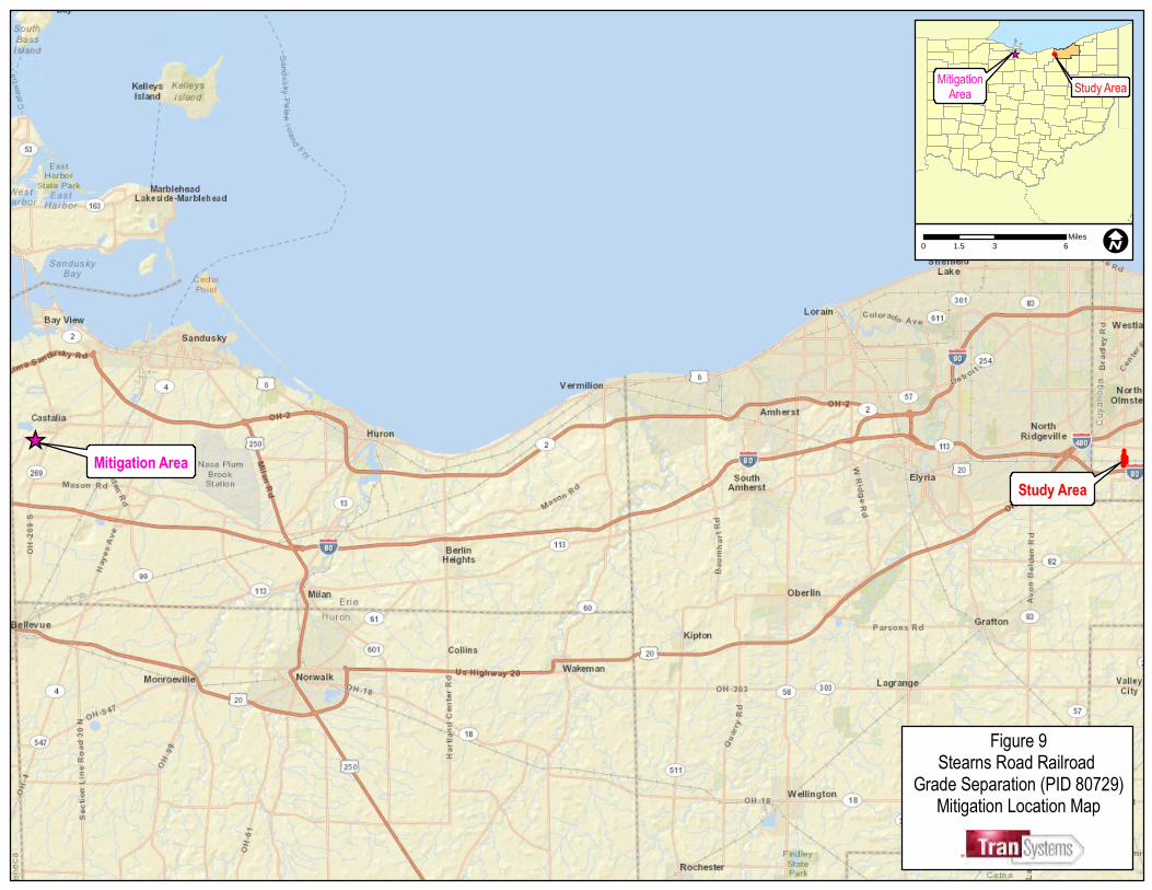
One jurisdictional wetland will be affected by the Preferred Alternative (Table 2, Appendix E). The Preferred Alternative will impact 1.78 acres of wetland habitat. The Ohio wetland antidegradation rule 3745-1-54 wetland chart, of the Administrative Code was used to determine the amount of proposed wetland mitigation that would be required as compensation for wetland impacts associated with the proposed project (Ohio EPA, 1998). The wetlands within the study area were evaluated using the Ohio Rapid Assessment Method: Version 5.0 (Mack, 2001); based on that assessment, the proposed impacted wetland is a Category 1 wetland (Table 2, Appendix E). The Preferred Alternative will impact 1.78 acres of Category 1 wetland. Numerous alternatives were explored to determine the preferred mitigative technique to compensate for unavoidable impacts to the Category 1 wetland. For wetland impacts, a total of 2.70 acres (1.5:1 mitigation ratio) of wetland credits will be purchased through the North Coast Regional Council of Park Districts at the Castalia Quarry mitigation site will be used (Figure 9, Appendix A). The Castalia Quarry site is located approximately 55 miles west of the project and is in the 04100011 HUC (Sandusky River watershed), which is within the Lake Erie drainage area (http://www.wetlandsandwatershed.com/index.html). Indiana Bat Mitigation Coordination was initiated by ODOT-OES on October 27, 2008. Comments were received from the USFWS on December 8, 2008. In their response, the USFWS stated that the project falls under the Programmatic Consultation between the USFWS, FHWA and ODOT. The USFWS concurred with the ODOT determination that the project, as proposed, may affect, but is not likely to adversely affect the Indiana bat (Myotis sodalist). The project is within the PC-1a category of project impacts; therefore, cutting date restrictions apply. The USFWS encourages the use of the revised guidelines of tree removal prior to April 1 or after September 30, as Indiana bats have been observed arriving at their traditional summer areas earlier in the spring and staying longer in the fall than previously documented. This recommendation is included as an environmental commitment to the project to mitigate adverse impacts to the bat species. 10k-1b. Minimal Degradation Alternative Wetland Mitigation The Minimal Degradation Alternative will impact 1.30 acres of wetland habitat, a difference of 0.48 acres than the Preferred Alternative. As mentioned in the previous section and in the Preferred Alternative, the proposed mitigation technique proposes to mitigate impacts off-site. For wetland impacts, purchased wetland credits through the North Coast Regional Council of Park Districts at the Castalia Quarry mitigation site will be used (Figure 9, Appendix A). The Castalia Quarry site is located approximately 55 miles west of the project and is in the 04100011 HUC (Sandusky River watershed), which is within the Lake Erie drainage area. Mitigation for the impacted wetland features will occur at a 1.5:1 ratio for Category 1 non-forested wetlands for a total of 2.00 acres of wetland mitigation off-site, 0.70 acres less than the Preferred Alternative. Indiana Bat Mitigation Indiana Bat mitigation requirements for the Minimal Degradation Alternative will be the same as the Preferred Alternative.
10k-1c. Non-Degradation Alternative No mitigation is proposed with the Non-Degradation Alternative, as no waterway impacts will occur as a result of this alternative.
EXHIBIT 7 REFERENCES CITED Cowardin, L.M., V. Carter, F.C. Golet, and E.T. LaRoe. 1979, reprinted 1992. Classification of wetlands and
deepwater habitats of the United States. U.S. Department of the Interior, Fish and Wildlife Service, Washington, DC.
Department of the Army (DA), Huntington District, Corps of Engineers. 2009. Jurisdictional determination
correspondence. Huntington, WV. Mack, J.J. 2001. Ohio rapid assessment method for wetlands, version 5.0, user’s manual, scoring forms. Ohio
Environmental Protection Agency. Columbus, OH Natural Resources Conservation Service (NRCS). 2010. Cuyahoga County 14 digit watersheds. United Sates
Department of Agriculture. http://www.oh.nrcs.usda.gov/technical/14-digit/images/cuyahoga_co.GIF. Ohio Department of Transportation (ODOT). 2010. Construction and Materials Specification Manual. Columbus, OH Ohio Department of Transportation (ODOT). 2007a. Biological Opinion on the Ohio Department of Transportation’s
Statewide Program for the federally listed Indiana Bat (Myotis sodalis). Office of Environmental Services. Columbus, OH.
Ohio Department of Transportation (ODOT). 2007b. Guidance for ESR’s and the Indiana Bat (TG-ECO-01-04). Office of
Environmental Services. Columbus, OH Ohio Environmental Protection Agency (Ohio EPA). 2004. Ohio EPA’s Division of Surface Water’s 2004 Integrated Report
Section 303(d) TMDL Priority List web page: http://www.epa.state.oh.us/dsw/tmdl/index.html#Ohio's%20303(d)%20List%20and%20Schedule.
Ohio Environmental Protection Agency (Ohio EPA). 2008b. Water Quality Standards. Chapter 3745-1 of the Ohio
Administrative Code. Rocky River drainage basin. http://www.epa.state.oh.us/dsw/rules/01-20.pdf . Division of Surface Water. Columbus, OH.
TranSystems. 2008. Level One Ecological Survey Report for Stearns Road Railroad Grade Separation Project (PID
807269) Cleveland, OH. TranSystems. 2010. Categorical Exclusion – Level Four. Cleveland, OH. U.S. Census Bureau. 2012. http://factfinder2.census.gov/faces/nav/jsf/pages/index.xhtml. U.S. Fish and Wildlife Service (USFWS). 2012. Federally-Listed Species by Ohio Counties. http://www.fws.gov/midwest/endangered/lists/ohio-cty.html Ecological Services, Columbus, OH.
U.S. Geological Survey (USGS). 1994. Topographical quadrangle maps (7.5-minute series). North Olmsted and West View, Ohio quadrangles. U.S. Department of the Interior. Washington, D.C.
Photo 1. Wetland A looking northeast at PEM wetland habitat.
Photo 2. Wetland A looking north at PEM wetland habitat and brush/dirt piles.
Stearns Road Railroad Grade Separation
PHOTO DOCUMENTATION
Cuyahoga County, Ohio
Photographer(s): B.M. Falkinburg
Date of Photograph: 2008
Project Number: P402060040
Photo 3. Railroad crossing at Stearns Road facing south.
Photo 4. Stearns Road facing north, north of railroad crossing.
Stearns Road Railroad Grade Separation
PHOTO DOCUMENTATION
Cuyahoga County, Ohio
Photographer(s): B.M. Falkinburg
Date of Photograph: 2008
Project Number: P402060040
Photo 5. Typical wooded habitat within the study area.
Photo 6. Typical old field habitat within the study area.
Stearns Road Railroad Grade Separation
PHOTO DOCUMENTATION
Cuyahoga County, Ohio
Photographer(s): B.M. Falkinburg
Date of Photograph: 2008
Project Number: P402060040
Appendix E Tables
Resource ID
Cowardin
Class / Stream
Class Hydrologic Connectivity Drianage Basin / HUC
Habitat Score
(ORAM / HHEI) /
Ohio EPA
Category
*Total Wetland
Area (acres) /
Stream Length
(L.F.) Adjacent Habitat
Wetland A PEM Unnamed Tributary to Rocky River Rocky River / 04110001 18.5 / Category 1 2.86 Roadway / Forest
Wetland B PEM / PFO Unnamed Tributary to Rocky River Rocky River / 04110001 20.5 / Category 1 0.17 Roadway / Forest
Stream 1 Modified Class I Unnamed Tributary to Rocky River Rocky River / 04110001 39 (HHEI) 103 Roadway / Forest
*Area is approximate, wetland extends beyond study area and was not delineated fully beyond
Resource ID
Cowardin
Class *Total Wetland Area (acres) Proposed Action
Volume Filled
(Cubic Yards)
Area Filled
(acres)
Percent Wetland Avoidance
within Construction Limits
Wetland A PEM 2.86 Fill 2,872 1.78 38%
Totals 2.86 2,872 1.78
*Area is approximate, wetland extends beyond study area and was not delineated fully beyond
Resource ID
Cowardin
Class *Total Wetland Area (acres) Proposed Action
Volume Filled
(Cubic Yards)
Area Filled
(acres)
Percent Wetland Avoidance
within Construction Limits
Wetland A PEM 2.86 Fill 2,097 1.30 55%
Totals 2.86 2,097 1.30
*Area is approximate, wetland extends beyond study area and was not delineated fully beyond
Table 2. Proposed Wetland Impacts for the Proposed Stearns Road Grade Separation- Preferred Alternative (PID-80729)
Table 3. Proposed Wetland Impacts for the Proposed Stearns Road Grade Separation- Minimal Degradation Alternative (PID-80729)
Table 1. Water Resources within the Stearns Road Grade Separation (PID-80729) Project Area
Item Description Preferred Alternative CostMinimal Degradation
Alternative CostNon-Degradation (No-Build) Alternative Cost
Real Estate $2,018,732 $1,943,239 $0
Roadway $1,566,550 $1,505,364 $0
Erosion Control $56,706 $56,706 $0
Drainage $533,204 $533,204 $0
Pavement $753,403 $753,403 $0
Retaining Wall $0 $1,590,000 $0
Structure $1,801,091 $1,801,091 $0
Water Work $213,801 $213,801 $0
Sanitary Sewers $309,642 $309,642 $0
Traffic Control $0 $0 $0
Maintenance of Traffic $0 $0 $0
General Items $0 $0 $0
Traffic Signaling/Lighting $0 $0 $0
Total Estimated Cost $7,253,129 $8,706,449 $0
Contengency & Inflation $2,103,407 $2,524,870 $0
Grand Total $9,356,536 $11,231,320 $0
Table 5. Estimated Cost of Water Pollution Controls and Temporary Erosion Controls by Alternative.
Item Description Preferred Alternative CostMinimal Degradation
Alternative CostNon-Degradation (No-Build) Alternative Cost
Erosion Control including BMP $56,706.00 $56,706.00 $0
Drainage including storm sewers and culverts $533,204.00 $533,204.00 $0
Total Estimated Cost $589,910.00 $589,910.00 $0
Contengency & Inflation $171,074 $215,317 $0
Grand Total $760,984 $805,227 $0
Table 4. Estimated Cost of Construction by Alternative.
1105 Schrock Road, Suite 400
Columbus, Ohio 43229
Main 614-433-7800
Proposed Non-Degradation Alternative for Stearns Road: Amendments to 401 Application
1
10a. Alternative Discussion
10a-3. Non-degradation Alternative
Due to the location and the extent of the existing wetlands in the project area, coupled with
FHWA and ODOT Roadway standards, a project to separate the rail road from the automobile
traffic on Stearns Road cannot be reasonably constructed without impacts to aquatic resources.
However, to meet the 401 requirements the Non-degradation Alternative will involve the
construction of a clear span bridge over the existing railroad tracks that extend from Bagley
Road to the northern edge of the study area as defined in Figure 1. The western end of Laurel
Lane will need to be elevated to meet the grade of the proposed Stearns Road Bridge.
Although the Non-degradation Alternative may be technically feasible the extreme costs both in
dollars and the affected adjacent residents would be in ordinate. The Non-degradation
Alternative was not developed through ODOT’s Project Development Process therefore no
plans have been created.
10b. Impacts on Water Quality and Aquatic Life by Alternative
10b-3 Non-degradation Alternative
No new impacts are expected in association with the Non-degradation Alternative.
10c. Cost Effectiveness
10c-1c Non-degradation Alternative
The Non-degradation Alternative may be technically feasible but the costs of a clear span bridge
in comparison to the Preferred Alternative are estimated to increase greatly (approximately
$50 million). Additionally, to eliminate all impacts to aquatic resources the development of a
clear span bridge would require all residences along Stearns Road in the project area to be
appropriated and demolished due to lack of access from the elevated proposed roadway.
10c-2c Non-degradation Alternative
It is estimated that the costs for the proposed Non-degradation Alternative would approach
$50 million. The cost increase would be due to exorbitant amounts of steel needed to
construct a clear span bridge, the increased costs for real estate appropriations, the specialized
construction techniques required to build such a large structure and the additional work to
elevate Laurel Road.
10d Sewage Projects: N/A no change required in application
10e Conservation Projects: No change required in application
10f Costs of Water Protection: See attached amended Table 5.
Proposed Non-Degradation Alternative for Stearns Road: Amendments to 401 Application
2
10g-1 Impacts on Human Health
10g-1c Non-degradation Alternative
Impacts to human health are expected to increase with the Non-Degradation Alternative due
to increase of size and scope of the project. Noise and air quality during construction will
increase in proportion to the size of the bridge and the increased time it will take to build the
larger structure.
10g-2 Impacts on Overall Quality and the value of the Water Resource
10g-2c Non-degradation Alternative: No change required in application
10h Social and Economic Benefits to be gained
10h-3 Non-degradation Alternative
The proposed Non-degradation Alternative would improve transportation connectivity in the region but the overall aesthetics and the cohesiveness of the Stearns Road would be greatly
changed by the clear span bridge.
10i Social and Economic Benefits to be lost
10i-3 Non-degradation Alternative
The loss of access to the proposed bridge would make it necessary to appropriate all the
residences and businesses along Stearns Road. The overall effect to the community would be
devastating.
10j-1 Environmental Benefits to be Lost: No change required in application
10j-2 No change required in application
10k Mitigation Techniques Proposed
10kk-1c Non-degradation Alternative
No aquatic resource mitigation will be required as the Non-degradation Alternative will not
impact any wetlands or streams. However, Indiana Bat mitigation will increase due to the need
to remove all the trees in the study area directly beneath or adjacent to the proposed bridge.
Table 4. Estimated Cost of Construction by Alternative.
Item Description
Preferred Alternative Cost
Minimal Degradation
Alternative Cost
Non-Degradation Alternative Cost
Real Estate $2,018,732 $1,943,239 The Non Degradation Alternative was not developed through ODOT’s Project Development Process therefore plans and a breakdown of costs were not developed. The overall costs of a clear span bridge (Non-Deg Alternative) from Bagley Road north over the project area is estimated to cost $50 million.
Roadway $1,566,550 $1,505,364
Erosion Control $56,706 $56,706
Drainage $533,204 $533,204
Pavement $753,403 $753,403
Retaining Wall $0 $1,590,000
Structure $1,801,091 $1,801,091
Water Work $213,801 $213,801
Sanitary Sewers $309,642 $309,642
Traffic Control $0 $0
Maintenance of Traffic $0 $0
General Items $0 $0
Traffic Signaling/Lighting $0 $0
Total Estimated Cost $7,253,129 $8,706,449
Contingency & Inflation $2,103,407 $2,524,870
Grand Total $9,356,536 $11,231,320
Table 5. Estimated Cost of Water Pollution Controls and Temporary Erosion Controls by Alternative.
Item Description
Preferred Alternative Cost
Minimal Degradation
Alternative Cost
Non-Degradation Alternative Cost
Erosion Control including BMP $56,706.00 $56,706.00 The Non Degradation Alternative was not developed through ODOT’s Project Development Process therefore plans and a breakdown of costs were not developed. Costs for erosion controls are estimated at $4 million.