Environmental Impact Analysis Hydrology and Water Quality Draft Environmental Impact Report 4.10-1 4.10 Hydrology and Water Quality This section presents the existing conditions, summarizes the regulatory and planning framework, and analyzes the impacts to the surface water and groundwater resources in Sonoma County, relative to the proposed project. Impacts to water supply and wastewater treatment are discussed in Section 4.18, Utilities and Service Systems. Extensive overlap exists in regulatory programs governing environmental aspects of water quality, drinking water quality, and the public health aspects of water supply protection. There is also overlap in the characterization of groundwater aquifers as potential water supply sources for rural communities in the county. 4.10.1 Environmental Setting Sonoma County falls in seven distinct watersheds, of which the Russian River watershed is the largest in terms of area, runoff volume, number of cities it passes through, and population adjacent to it. Due to the large size of the Russian River watershed and the complexity of the coastal watersheds, it and several of the coastal watersheds are divided into subbasin units whose size and boundaries are determined by several common traits, including runoff patterns, geology, topography, vegetation, and land use. The watersheds and subbasins for each grouping of Potential Sites are listed in Table 4.10-1. Table 4.10-1 Watersheds and Sub-Watersheds in Sonoma County Potential Sites Watershed Sub-watershed Geyserville (all sites) Middle Russian River Sausal Creek-Russian River Guerneville (all sites) Lower Russian River Dutch Bill Creek-Russian River Larkfield (LAR-1, LAR-2, LAR-6, LAR-8) Mark West Creek Porter Creek-Mark West Creek Larkfield (LAR-3, LAR-4, LAR-5, LAR-7) Mark West Creek Windsor Creek Forestville (all sites) Lower Russian River Green Valley Creek Forestville (northern half of FOR-2 only) Lower Russian River Porter Creek-Russian River Graton (all sites) Lower Russian River Green Valley Creek Graton (southern portion of GRA-3 and southeastern portion of GRA-5) Mark West Creek Lower Laguna De Santa Rosa Santa Rosa (all sites) Mark West Creek Upper Laguna De Santa Rosa Glen Ellen (all sites) Sonoma Creek-Frontal San Pablo Bay Estuaries Upper Sonoma Creek Agua Caliente (all sites) Sonoma Creek-Frontal San Pablo Bay Estuaries Lower Sonoma Creek Penngrove (all sites) Petaluma River-Frontal San Pablo Bay Estuaries Petaluma River Petaluma (all sites) Petaluma River-Frontal San Pablo Bay Estuaries Petaluma River Sonoma (all sites) Carneros Creek-Frontal San Pablo Bay Estuaries Schell Creek-Frontal San Pablo Bay Estuaries Source: United States Environmental Protection Agency (USEPA) 2020 The climate in Sonoma County is Mediterranean with warm dry summers and cool, damp winters. Temperatures along the coast are generally cool throughout summer and seldom drop below
Transcript
Environmental Impact Analysis Hydrology and Water Quality
Draft Environmental Impact Report 4.10-1
4.10 Hydrology and Water Quality
This section presents the existing conditions, summarizes the regulatory and planning framework, and analyzes the impacts to the surface water and groundwater resources in Sonoma County, relative to the proposed project. Impacts to water supply and wastewater treatment are discussed in Section 4.18, Utilities and Service Systems. Extensive overlap exists in regulatory programs governing environmental aspects of water quality, drinking water quality, and the public health aspects of water supply protection. There is also overlap in the characterization of groundwater aquifers as potential water supply sources for rural communities in the county.
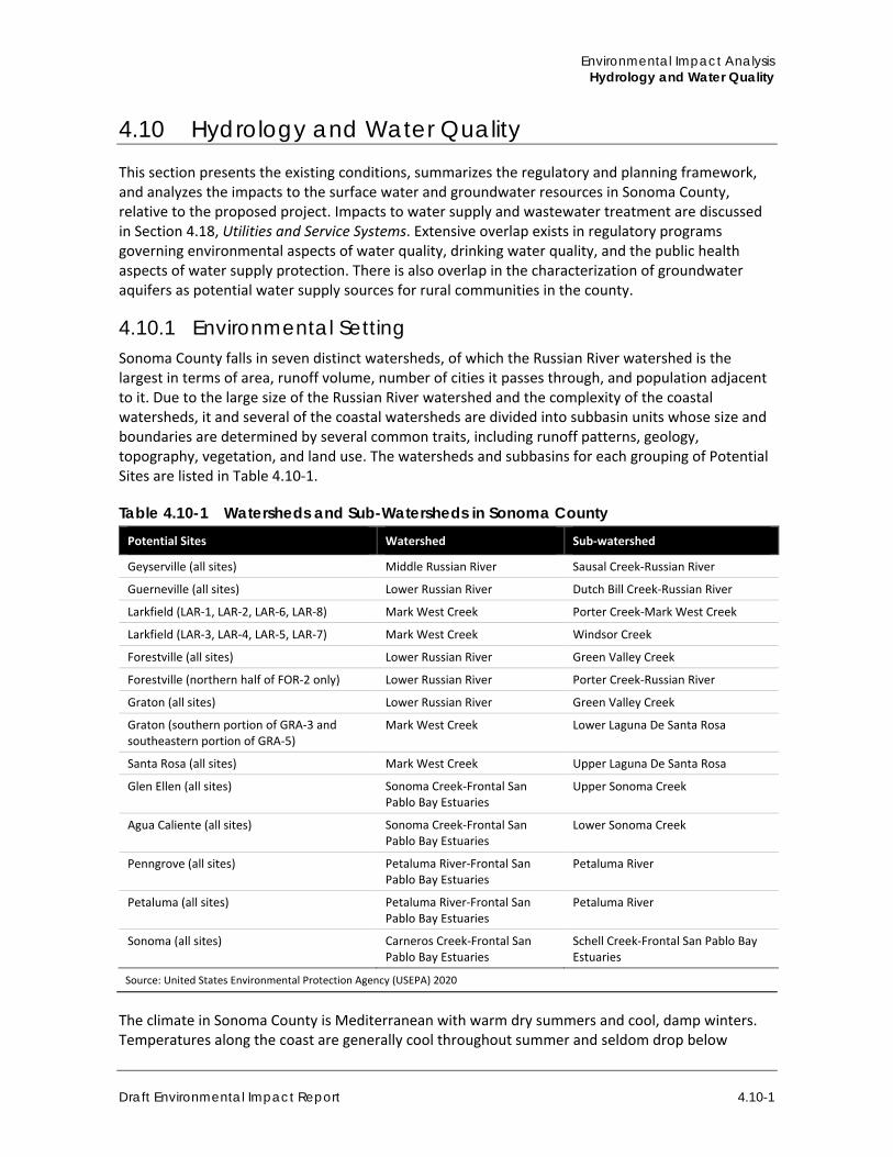
4.10.1 Environmental Setting Sonoma County falls in seven distinct watersheds, of which the Russian River watershed is the largest in terms of area, runoff volume, number of cities it passes through, and population adjacent to it. Due to the large size of the Russian River watershed and the complexity of the coastal watersheds, it and several of the coastal watersheds are divided into subbasin units whose size and boundaries are determined by several common traits, including runoff patterns, geology, topography, vegetation, and land use. The watersheds and subbasins for each grouping of Potential Sites are listed in Table 4.10-1.
Table 4.10-1 Watersheds and Sub-Watersheds in Sonoma County Potential Sites Watershed Sub-watershed
Geyserville (all sites) Middle Russian River Sausal Creek-Russian River
Guerneville (all sites) Lower Russian River Dutch Bill Creek-Russian River
Larkfield (LAR-1, LAR-2, LAR-6, LAR-8) Mark West Creek Porter Creek-Mark West Creek
Larkfield (LAR-3, LAR-4, LAR-5, LAR-7) Mark West Creek Windsor Creek
Forestville (all sites) Lower Russian River Green Valley Creek
Forestville (northern half of FOR-2 only) Lower Russian River Porter Creek-Russian River
Graton (all sites) Lower Russian River Green Valley Creek
Graton (southern portion of GRA-3 and southeastern portion of GRA-5)
Mark West Creek Lower Laguna De Santa Rosa
Santa Rosa (all sites) Mark West Creek Upper Laguna De Santa Rosa
Glen Ellen (all sites) Sonoma Creek-Frontal San Pablo Bay Estuaries
Upper Sonoma Creek
Agua Caliente (all sites) Sonoma Creek-Frontal San Pablo Bay Estuaries
Lower Sonoma Creek
Penngrove (all sites) Petaluma River-Frontal San Pablo Bay Estuaries
Petaluma River
Petaluma (all sites) Petaluma River-Frontal San Pablo Bay Estuaries
Petaluma River
Sonoma (all sites) Carneros Creek-Frontal San Pablo Bay Estuaries
Schell Creek-Frontal San Pablo Bay Estuaries
Source: United States Environmental Protection Agency (USEPA) 2020
The climate in Sonoma County is Mediterranean with warm dry summers and cool, damp winters. Temperatures along the coast are generally cool throughout summer and seldom drop below
Sonoma County Rezone Sites for Housing Project
4.10-2
freezing in winter. Inland temperature can vary greatly, with occasional highs exceeding 100 degrees Fahrenheit and lows sometimes falling below freezing (U.S. Climate Data 2020).
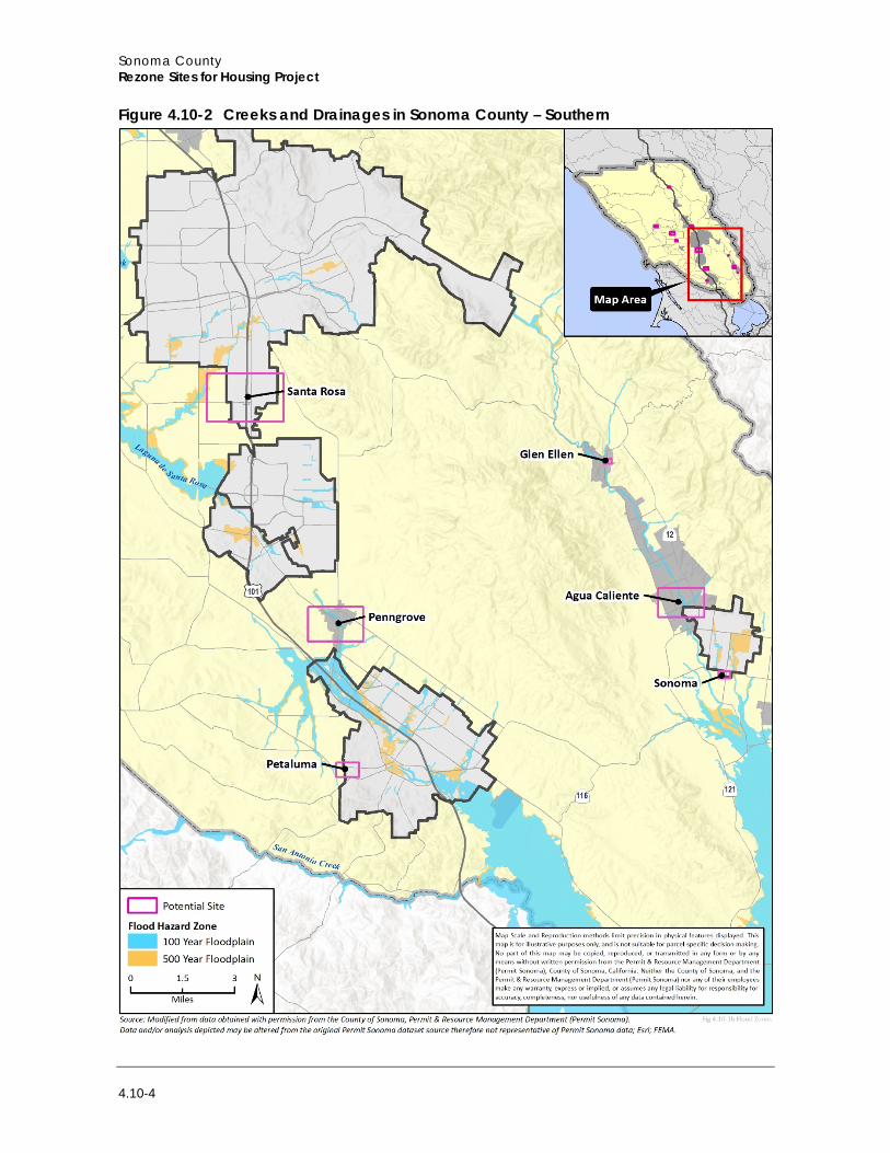
Three major creeks or rivers are in Sonoma County: the Russian River, Sonoma Creek, and Petaluma River. The Russian River is approximately 110 miles in length, originates in the Coast Ranges, and discharges into the Pacific Ocean. Sonoma Creek is 22 miles in length, originates at Bald Mountain and discharges into San Pablo Bay. Petaluma Creek is 18 miles in length, originates in Penngrove, and discharges into the San Pablo Bay, Napa Sonoma Marsh, and Petaluma Point. Figure 4.10-1 and Figure 4.10-2 show the creeks and drainages within the County near the Potential Sites.
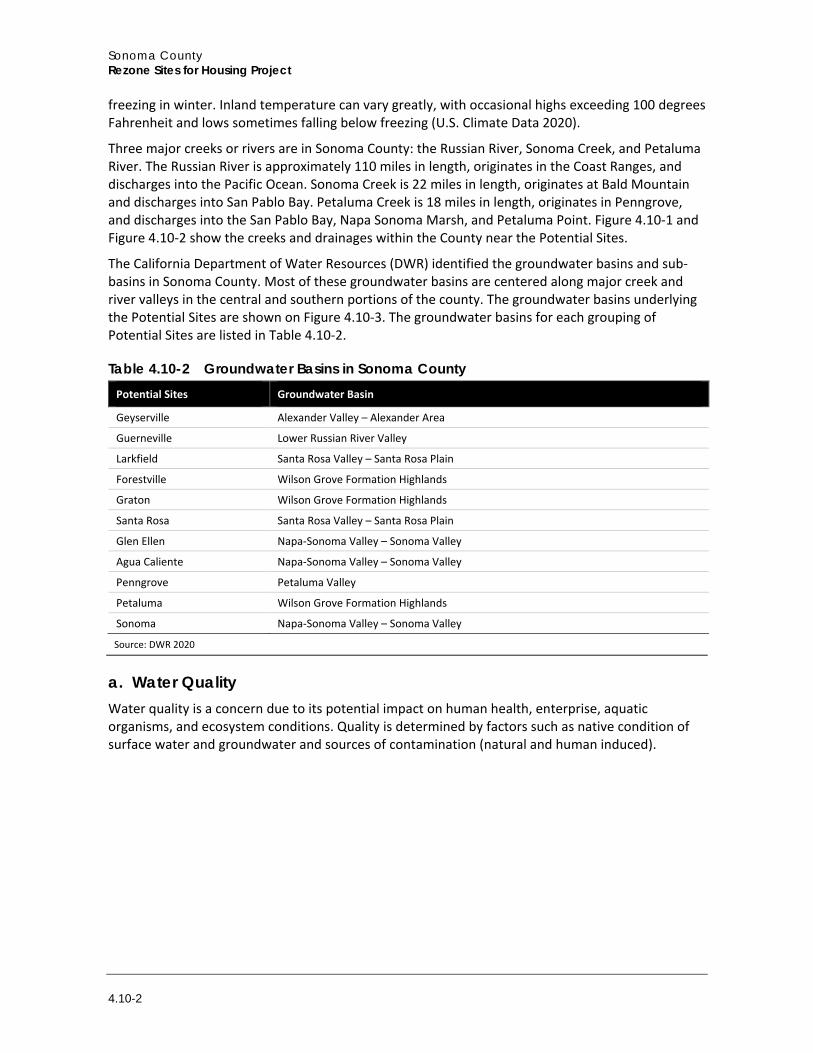
The California Department of Water Resources (DWR) identified the groundwater basins and sub-basins in Sonoma County. Most of these groundwater basins are centered along major creek and river valleys in the central and southern portions of the county. The groundwater basins underlying the Potential Sites are shown on Figure 4.10-3. The groundwater basins for each grouping of Potential Sites are listed in Table 4.10-2.
Table 4.10-2 Groundwater Basins in Sonoma County Potential Sites Groundwater Basin
Geyserville Alexander Valley – Alexander Area
Guerneville Lower Russian River Valley
Larkfield Santa Rosa Valley – Santa Rosa Plain
Forestville Wilson Grove Formation Highlands
Graton Wilson Grove Formation Highlands
Santa Rosa Santa Rosa Valley – Santa Rosa Plain
Glen Ellen Napa-Sonoma Valley – Sonoma Valley
Agua Caliente Napa-Sonoma Valley – Sonoma Valley
Penngrove Petaluma Valley
Petaluma Wilson Grove Formation Highlands
Sonoma Napa-Sonoma Valley – Sonoma Valley
Source: DWR 2020
a. Water Quality Water quality is a concern due to its potential impact on human health, enterprise, aquatic organisms, and ecosystem conditions. Quality is determined by factors such as native condition of surface water and groundwater and sources of contamination (natural and human induced).
Environmental Impact Analysis Hydrology and Water Quality
Draft Environmental Impact Report 4.10-3
Figure 4.10-1 Creeks and Drainages in Sonoma County – Northern
Sonoma County Rezone Sites for Housing Project
4.10-4
Figure 4.10-2 Creeks and Drainages in Sonoma County – Southern
Environmental Impact Analysis Hydrology and Water Quality
Draft Environmental Impact Report 4.10-5
Figure 4.10-3 Groundwater Basins and Sub-basins in Sonoma County
Sonoma County Rezone Sites for Housing Project
4.10-6
Surface Water In Sonoma County, the Sonoma Creek and Petaluma River watersheds are in the San Francisco Bay Regional Water Quality Control Board (RWQCB) jurisdiction, and the remainder of the county is within the jurisdiction of the North Coast RWQCB. Waste discharge requirements are set by each RWQCB for point sources, including industrial and commercial uses, community wastewater management systems and individual septic systems (County of Sonoma 2008). Water quality issues in the county arise primarily from polluted runoff discharges, which can include pesticides, fertilizers, green waste, animal waste, human waste, petroleum hydrocarbons such as gasoline and motor oil, trash, and other constituents of concern. Stormwater flowing over roadways and other transportation assets carries urban pollutants through natural drainage systems or man-made storm drain structures to a body of surface water.
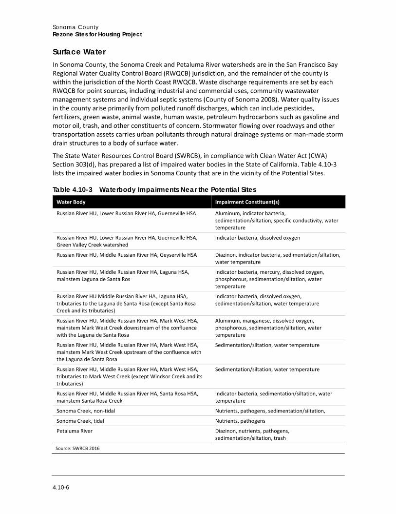
The State Water Resources Control Board (SWRCB), in compliance with Clean Water Act (CWA) Section 303(d), has prepared a list of impaired water bodies in the State of California. Table 4.10-3 lists the impaired water bodies in Sonoma County that are in the vicinity of the Potential Sites.
Table 4.10-3 Waterbody Impairments Near the Potential Sites Water Body Impairment Constituent(s)
Russian River HU, Lower Russian River HA, Guerneville HSA Aluminum, indicator bacteria, sedimentation/siltation, specific conductivity, water temperature
Russian River HU, Lower Russian River HA, Guerneville HSA, Green Valley Creek watershed
Indicator bacteria, dissolved oxygen
Russian River HU, Middle Russian River HA, Geyserville HSA Diazinon, indicator bacteria, sedimentation/siltation, water temperature
Russian River HU, Middle Russian River HA, Laguna HSA, mainstem Laguna de Santa Ros
Indicator bacteria, mercury, dissolved oxygen, phosphorous, sedimentation/siltation, water temperature
Russian River HU Middle Russian River HA, Laguna HSA, tributaries to the Laguna de Santa Rosa (except Santa Rosa Creek and its tributaries)
Indicator bacteria, dissolved oxygen, sedimentation/siltation, water temperature
Russian River HU, Middle Russian River HA, Mark West HSA, mainstem Mark West Creek downstream of the confluence with the Laguna de Santa Rosa
Aluminum, manganese, dissolved oxygen, phosphorous, sedimentation/siltation, water temperature
Russian River HU, Middle Russian River HA, Mark West HSA, mainstem Mark West Creek upstream of the confluence with the Laguna de Santa Rosa
Sedimentation/siltation, water temperature
Russian River HU, Middle Russian River HA, Mark West HSA, tributaries to Mark West Creek (except Windsor Creek and its tributaries)
Sedimentation/siltation, water temperature
Russian River HU, Middle Russian River HA, Santa Rosa HSA, mainstem Santa Rosa Creek
Indicator bacteria, sedimentation/siltation, water temperature
Sonoma Creek, non-tidal Nutrients, pathogens, sedimentation/siltation,
Sonoma Creek, tidal Nutrients, pathogens
Petaluma River Diazinon, nutrients, pathogens, sedimentation/siltation, trash
Source: SWRCB 2016
Environmental Impact Analysis Hydrology and Water Quality
Draft Environmental Impact Report 4.10-7
To address surface water quality impairments, the North Coast RWQCB and San Francisco Bay RWQCB prescribe total maximum daily loads (TMDL) to impaired water bodies in Sonoma County for pathogens, fecal indicator bacteria, sedimentation, temperature, and mercury (San Francisco Bay RWQCB 2017; North Coast RWQCB 2020).
Groundwater Water quality in Sonoma County varies depending on the underlying groundwater basin. None of the basins in the county are designated as critically over-drafted (DWR 2020), although some basins were given high priority under the Sustainable Groundwater Management Act (refer to Section 4.10.2, Regulatory Setting, below). Factors that contribute to the decline of groundwater quality include percolation of agricultural runoff contaminated with fertilizers and pesticides into the water table; percolation of water from public and private sewage treatment systems; and percolation of contaminated urban runoff.
The Alexander Valley basin, which underlies the Geyserville sites, exceeds the limits for secondary inorganics, but generally has good water quality (DWR 2004a). The Lower Russian River Valley basin, which underlies the Guerneville sites, has measured water quality impairments of primary and secondary inorganics as well as radiological constituents (DWR 2004b). Water quality concerns in the Santa Rosa Plan Groundwater Basin include arsenic, chloride, total dissolved solids, and nitrate. This basin encompasses the Larkfield and Santa Rosa sites (Santa Rosa Plan Groundwater Sustainability Agency 2020). The Wilson Grove Formation Highlands basin underlies the Forestville, Graton, and Petaluma sites, and has limited groundwater quality information, except for average total dissolved solids measurements of 253 milligrams per liter (DWR 2014). Water quality issues in the Sonoma Valley Groundwater Basin include total dissolved solids and nitrate. This basin encompasses the Glen Ellen, Agua Caliente, and Sonoma sites (Sonoma Valley County Sanitation District 2013). Water quality constituents of concern in the Petaluma Valley Groundwater Basin include arsenic, boron, total dissolved solids, chloride, and nitrate. This basin encompasses the Penngrove sites (Petaluma Valley Groundwater Sustainable Agency 2020).
b. Water Supply Most of the Potential Sites are within the Sonoma County Water Agency’s (Sonoma Water) service area, including sites in Forestville, Santa Rosa, Glen Ellen, Agua Caliente, Petaluma, and Sonoma. The Sweetwater Springs Water District (SSWD) serves Site GUE-1; California American Water (Cal-Am, a private water company) serves the remaining Geyserville, Guerneville, and Larkfield sites; the Penngrove/Kenwood Water Company (private) serves the Penngrove sites; and private wells serve each of the Graton sites.
Sonoma Water provides water sourced primarily from the Russian River with some groundwater extracted from the Santa Rosa Plain Groundwater Basin. Sonoma Water’s customers also receive water through local sources, including local surface water, local groundwater, and recycled water. SSWD supplies water extracted from groundwater near the Russian River. Table 4.10-4 provides the annual water supply of each water supplier to the Potential Sites.
Sonoma County Rezone Sites for Housing Project
4.10-8
Table 4.10-4 Water Supply in Sonoma County Water Supplier Surface Water Supply (AFY) Groundwater Supply (AFY) Aggregate Water Supply (AFY)
Sonoma Water1 2,300 75,000 77,300
SSWD2 – 1,137 1,137
Cal-Am3 6,085 26,598 32,643
Total 8,385 102,735 111,080 1 Source: Sonoma Water 2016 2 Source: SSWD 2016 3 Source: Cal-Am 2016 (Sacramento District water supply data only, assuming purchased water from the City of Sacramento and Placer
County Water Agency are solely from surface water sources)
Groundwater Recharge During and after a storm event, rainfall may infiltrate into the ground surface, and move down through the soil as groundwater recharge. Land areas vary in their capacity to recharge based on soil conditions and the underlying geology. In Sonoma County, rivers and stream corridors are important sources for groundwater recharge, as are areas underlain by permeable geologic formations.
Groundwater generally occurs in geologic formations with high water-holding capacity (aquifers) on a local scale, and groundwater basins on a regional scale. Contiguous aquifers allow groundwater to migrate between them, and sometimes multiple aquifers occur, separated by less permeable or impermeable (clay) layers called aquacludes.
Groundwater is an important source of agricultural, industrial, and domestic water supply in Sonoma County. It is accessed through wells drilled into the zone of saturation. Not all areas in the county have groundwater present in sufficient volume to meet the requirements of areas otherwise suitable for development as the basin may have a lower rate of recharge or have insufficient potable water. Overdrawing the groundwater supply can lead to undesirable results, such as the following:
1. Physical harm to the aquifer from consolidation 2. Ground settlement 3. Reduced water quality from intrusion of less desirable water from other areas 4. Interference with prior rights of adjacent groundwater areas 5. Declines in the water table
Recharge of groundwater typically occurs along the major streams and their principal tributaries. The principal water bearing formations in Sonoma County groundwater basins are typically alluvium, a deposit of clay, silt, sand, and gravel left by flowing streams in a river valley or delta that typically produces fertile soil. While other geologic units can yield adequate amounts of water in some areas, much of the county may not have dependable groundwater supplies (County of Sonoma 2008).
Groundwater depth measurements near the Potential Sites are provided in Table 4.10-5, based on data provided by the United States Geological Survey for nearby wells.
Environmental Impact Analysis Hydrology and Water Quality
Draft Environmental Impact Report 4.10-9
Table 4.10-5 Approximate Depth to Groundwater near Potential Sites Potential Site Nearest Groundwater Depth Measurement (year)
Geyserville 70 feet (2012)
Guerneville 24 feet (2019)
Larkfield 37 feet (2012)
Forestville, Graton 50 feet (1950)
Santa Rosa 16 feet (2012)
Glen Ellen 7.5 feet (2003)
Agua Caliente 25 feet (2003)
Penngrove 69 feet (2019)
Petaluma 79 feet (2012)
Sonoma 27 feet (2012)
Source: United States Geological Survey 2020
c. Hazards
Flooding and Dam Inundation Flooding or inundation by water can occur because of storm events, dam failure, seiche, and tsunami. Flooding is the most frequent natural hazard impacting Sonoma County, with most frequent flooding occurring along the Russian River, Petaluma River, and Sonoma Creek, as well as tributaries within these watersheds. Figure 4.10-4 through Figure 4.10-8 shows the 100-year and 500-year floodplains in region based on the floodplain mapping by the Federal Emergency Management Agency (FEMA). As shown therein, the following sites are partially within the 100-year floodplain: GUE-4, GRA-2, AGU-1, AGU-2, PEN-8, and PEN-9.
Inundation can result from dam failure, which refers to the breakdown, collapse, or other failure of a dam structure characterized by the uncontrolled release of impounded water. The most common cause of dam failure is prolonged rainfall that produces flooding, although other causes include natural events such as earthquakes or landslides and structural deterioration. In the event of dam failure, inundation could affect Potential Sites located in Geyserville and Guerneville (County of Sonoma 2017). A failure at Warm Springs Dam would result in flooding of Guerneville sites, and a failure at Coyote Valley Dam would result in flooding at Geyserville sites (County of Sonoma 2017).
Tsunami and Seiche Tsunamis are high sea waves that are caused by earthquake, submarine landslide, or other disturbances. While the Pacific Ocean and San Pablo Bay bound Sonoma County to the west and south, respectively, none of the Potential Sites are in or near a designated tsunami inundation zone (California Department of Conservation 2020).
A seiche is a temporary disturbance or oscillation in water level of a lake or partially enclosed body of water, usually caused by changes in atmospheric pressure. There are several small lakes and reservoirs throughout the County, but none are within 0.5 mile of a Potential Site. While an earthquake could generate a seiche in these lakes and reservoirs, potential inundation would remain localized to low-lying areas along the perimeter of the reservoirs.
Sonoma County Rezone Sites for Housing Project
4.10-10
Figure 4.10-4 FEMA Floodplain Map – Countywide
Environmental Impact Analysis Hydrology and Water Quality
Draft Environmental Impact Report 4.10-11
Figure 4.10-5 FEMA Floodplain Map – Guerneville
Sonoma County Rezone Sites for Housing Project
4.10-12
Figure 4.10-6 FEMA Floodplain Map – Graton
Environmental Impact Analysis Hydrology and Water Quality
Draft Environmental Impact Report 4.10-13
Figure 4.10-7 FEMA Floodplain Map – Agua Caliente
Sonoma County Rezone Sites for Housing Project
4.10-14
Figure 4.10-8 FEMA Floodplain Map – Penngrove
Environmental Impact Analysis Hydrology and Water Quality
Draft Environmental Impact Report 4.10-15
4.10.2 Regulatory Setting
a. Federal Regulations
Clean Water Act Congress enacted the CWA, formerly the Federal Water Pollution Control Act of 1972, to restore and maintain the chemical, physical, and biological integrity of the waters of the United States. The CWA requires states to set standards to protect, maintain, and restore water quality through the regulation of point source and non-point source discharges to surface water. Those discharges are regulated by the National Pollution Discharge Elimination System (NPDES) permit process (CWA Section 402). The SWRCB and its nine RWQCBs administer the NPDES permits. In Sonoma County, NPDES permits are administered by the North Coast RWQCB and San Francisco Bay RWQCB.
Individual projects that disturb more than one acre are required to obtain NPDES coverage under the California General Permit for Stormwater Discharges Associated with Construction and Land Disturbance Activities (Construction General Permit). The Construction General Permit requires the development and implementation of a Stormwater Pollution Prevention Plan (SWPPP) describing best management practices (BMP) the discharger would use to prevent and retain stormwater runoff. The SWPPP must contain a visual monitoring program; a chemical monitoring program for “non-visible” pollutants to be implemented if BMPs fail; and a sediment monitoring plan if the site discharges directly to a waterbody listed on the 303(d) list for sediment.
Section 401 of the CWA requires any activity that would result in discharge into waters of the U.S. be certified by the RWQCB. This certification ensures the proposed activity would not violate State and/or federal water quality standards. Section 404 of the CWA authorizes the U.S. Army Corps of Engineers to regulate the discharge of dredged or fill material to the waters of the U.S. and adjacent wetlands. Discharges to waters of the U.S. must be avoided where possible and minimized and mitigated where avoidance is not possible. Section 303(d) of the CWA requires states to establish TMDL programs for streams, lakes, and coastal waters that do not meet certain water quality standards.
Applicants of construction projects disturbing one or more acre of soil are required to file for coverage under the SWRCB, Order No. 99-08-DWQ, NPDES General Permit No. CAS000002 for Discharges of Storm Water Runoff Associated with Construction Activity (General Permit).
National Flood Insurance Act / Flood Disaster Protection Act The National Flood Insurance Act of 1968 made flood insurance available for the first time. The Flood Disaster Protection Act of 1973 made the purchase of flood insurance mandatory for the protection of property located in Special Flood Hazard Areas. These laws are relevant because they led to mapping of regulatory floodplains and to local management of floodplain areas according to guidelines that include prohibiting or restricting development in flood hazard zones.
b. State Regulations
Porter-Cologne Water Quality Control Act The Porter-Cologne Water Quality Control Act of 1967 requires the SWRCB and the nine RWQCBs to adopt water quality criteria to protect State waters. These criteria include the identification of beneficial uses, narrative and numerical water quality standards, and implementation procedures.
Sonoma County Rezone Sites for Housing Project
4.10-16
The Water Quality Control Plan, or Basin Plan, protects designated beneficial uses of State waters through the issuance of waste discharge requirements and through the development of TMDLs. Anyone proposing to discharge waste that could affect the quality of the waters of the State must make a report of the waste discharge to the RWQCB or SWRCB as appropriate, in compliance with the Porter-Cologne Act.
Sustainable Groundwater Management Act In September 2014, Governor Brown signed legislation requiring that California’s critical groundwater resources be sustainably managed by local agencies. The Sustainable Groundwater Management Act gives local agencies the power to sustainably manage groundwater and requires Groundwater Sustainability Plans (GSP) to be developed for medium- and high-priority groundwater basins. The Larkfield and Santa Rosa sites are in the Santa Rosa Plain GSA, which has similarly prepared a draft GSP that is required to be adopted by 2022. The Glen Ellen, Agua Caliente, and Sonoma sites are within the Sonoma Valley GSA, which also has prepared a draft GSP required to be adopted by 2022. The Penngrove sites are within the Petaluma Groundwater Sustainability Agency (GSA), which has prepared a Draft GSP. The Petaluma GSP is required to be adopted by 2022. While other Potential Sites are underlain by groundwater basins, they are not within a GSA.
Antidegradation Policy California’s antidegradation policy, formally known as the Statement of Policy with Respect to Maintaining High Quality Waters in California, restricts degradation of surface and ground waters. It protects waters where existing water quality is higher than necessary for the protection of beneficial uses. Any actions with the potential to adversely affect water quality must be consistent with the maximum benefit to the people of the State; not unreasonably affect present and anticipated beneficial use of the water; and not result in water quality less than prescribed in water quality plans and policies.
Cobey-Alquist Floodplain Management Act The Cobey-Alquist Floodplain Management Act (Water Code Section 8400 et seq.) gives support to the National Flood Insurance Program by encouraging local governments to plan, adopt, and enforce land use regulations for floodplain management, to protect people and property from flooding hazards. The Act also identifies requirements that jurisdictions must meet to receive State financial assistance for flood control.
California Green Building Standards Code The California Green Building Standards Code (California Code of Regulations, Title 24, Part 11) includes mandatory measures for residential and nonresidential development. For example, Section 4.106.2 requires residential projects that disturb less than one acre and are not part of a larger common plan of development to manage stormwater drainage during construction through on-site retention basins, filtration systems, and/or compliance with a stormwater management ordinance. Section 5.106.1 requires newly constructed nonresidential projects and additions of less than one acre to prevent the pollution of stormwater runoff from construction through compliance with a local ordinance or implementing BMPs that address soil loss and good housekeeping to manage equipment, materials, and wastes. Section 5.303 sets measures for indoor water use for non-residential development requiring metering devices to conserve water.
Environmental Impact Analysis Hydrology and Water Quality
Draft Environmental Impact Report 4.10-17
Urban Water Management Planning Act In 1983, the California Legislature enacted the Urban Water Management Planning Act (Water Code, Section 10610 et seq.), which requires urban water suppliers to develop water management plans to actively pursue the efficient use of available supplies. This Act also requires the provision of water service to be affordable to lower income households (Section 10631.1). Similarly, Government Code Section 65589.7 (Senate Bill [SB] 1087) requires water service providers to reserve water allocations for low income housing. Every five years, water suppliers are required to develop Urban Water Management Plans (UWMP) to identify short-term and long-term water demand management measures to meet growing water demands. Sonoma Water has prepared an UWMP, dated June 2016; SSWD’s UWMP is dated October 2016; and Cal-Am’s UWMP for the Sacramento Region1 is dated October 2016, but this UWMP was published prior to Cal-Am’s expansion to serve the Geyserville sites.
State Water Conservation Requirements Executive Order B-37-16 established a new water use efficiency framework for California. The order bolstered the state’s drought resilience and preparedness by establishing longer-term water conservation measures that include permanent monthly water use reporting, new urban water use targets, reducing system leaks and eliminating clearly wasteful practices, strengthening urban drought contingency plans, and improving agricultural water management and drought plans. Based on monthly water use reporting, most urban water suppliers reported sufficient supplies to meet demand in three additional dry years and are not subject to state conservation mandates. On February 8, 2017, SWRCB adopted an emergency water conservation regulation to amend and extend the May 2016 regulation. The amended regulation allows certain suppliers the opportunity to submit or resubmit their water supply reliability assessments.
c. Regional and Local
Municipal Separate Storm Sewer System RWQCBs issue stormwater discharge permits, with a Phase I Municipal Separate Storm Sewer System (MS4) (Order R1-2015-0030) applicable to sites in the North Coast Region RWQCB (including Potential Sites in Guerneville, Larkfield, Forestville, Graton, and Santa Rosa); and a Phase II MS4 (Order 2013-001-DWQ) applicable to sites in the San Francisco Bay RWQCB (including Potential Sites in Glen Ellen, Agua Caliente, Penngrove, Petaluma, and Sonoma) (County of Sonoma 2020). No MS4 permits are established for the remaining areas of the county (including Geyserville Potential Sites) (County of Sonoma 2020). The County, City of Santa Rosa, and Sonoma Water implement the Phase II MS4 permit. The MS4 programs implement and enforce BMPs to reduce the discharge of pollutants from municipal separate storm sewer systems.
Low Impact Development Manual The 2017 Storm Water Low Impact Development Technical Design Manual (LID Manual) provides technical guidance for project designs that require the implementation of permanent stormwater BMPs. This manual supersedes the 2005 Standard Urban Storm Water Mitigation Plan and satisfies Order R1-2015-0030, NPDES Permit CA0025054. While the City of Santa Rosa maintains the LID
1 Please note that Cal-Am’s Sacramento Region covers portions of Sonoma County, including Geyserville.
Sonoma County Rezone Sites for Housing Project
4.10-18
Manual, the County of Sonoma is a co-permittee along with the City and implements the LID Manual on projects in the unincorporated county (City of Santa Rosa 2017).
Sonoma County General Plan The County General Plan was adopted by the Sonoma County Board of Supervisors Resolution 08-0808 on September 23, 2008. The County General Plan includes broad goals and policies aimed at protecting the county’s water supply and water quality and protecting against flood hazards. Goals and policies from the County General Plan are provided below.
Goal WR-1: Protect, restore, and enhance the quality of surface and groundwater resources to meet the needs of all reasonable beneficial uses.
Objective WR-1.2: Avoid pollution of stormwater, water bodies and groundwater. Policy WR-1c: Prioritize stormwater management measures in coordination with the RWQCB direction, focusing first upon watershed areas that are urbanizing and watersheds with impaired water bodies. Work cooperatively with the RWQCBs to manage the quality and quantity of stormwater runoff from new development and redevelopment in order to: (1) Prevent, to the maximum extent practicable, pollutants from reaching stormwater
conveyance systems. (2) Ensure, to the maximum extent practicable, that discharges from regulated municipal
storm drains comply with water quality objectives. (3) Limit, to the maximum extent practicable, stormwater from post development sites to pre-
development quantities. (4) Conserve and protect natural areas to the maximum extent practicable.
Policy WR-1g: Minimize deposition and discharge of sediment, debris, waste and other pollutants into surface runoff, drainage systems, surface water bodies, and groundwater. Policy WR-1h: Require grading plans to include measures to avoid soil erosion and consider upgrading requirements as needed to avoid sedimentation in stormwater to the maximum extent practicable. Policy WR-1q: Require new development projects to evaluate and consider naturally occurring and human caused contaminants in groundwater.
Goal WR-2: Manage groundwater as a valuable and limited shared resource.
Objective WR-2.3: Encourage new groundwater recharge opportunities and protect existing groundwater recharge areas. Objective WR-2.5: Avoid additional land subsidence caused by groundwater extraction. Policy WR-2e: Require proof of groundwater with a sufficient yield and quality to support proposed uses in Class 3 and 4 water areas.2 Require test wells or the establishment of community water systems in Class 4 water areas. Test wells may be required in Class 3 areas. Deny discretionary applications in Class 3 and 4 areas unless a hydrogeologic report establishes that groundwater quality and quantity are adequate and will not be adversely impacted by the cumulative amount of development and uses allowed in the area, so that the proposed use will not cause or exacerbate an overdraft condition in a groundwater basin or subbasin. Procedures
2 Class 3 refers to a marginal groundwater area. Class 4 refers to low/highly variable water yield areas.
Environmental Impact Analysis Hydrology and Water Quality
Draft Environmental Impact Report 4.10-19
for proving adequate groundwater should consider groundwater overdraft, land subsidence, saltwater intrusion, and the expense of such study in relation to the water needs of the project.
Goal WR-4: Increase the role of conservation and safe, beneficial reuse in meeting water supply needs of both urban and rural users.
Objective WR-4.1: Increase the use of recycled water where it meets all applicable regulatory standards and is the appropriate quality and quantity for the intended use. Objective WR-4.2: Promote and encourage the efficient use of water by all water users. Objective WR-4.3: Conserve and recognize stormwater as a valuable resource. Policy WR-4b: Use water effectively and reduce water demand by developing programs to: (1) Increase water conserving design and equipment in new construction, including the use of
design and technologies based on green building principles, (2) Educate water users on water conserving landscaping and other conservation measures, (3) Encourage retrofitting with water conserving devices, (4) Design wastewater collection systems to minimize inflow and infiltration, and (5) Reduce impervious surfaces to minimize runoff and increase groundwater recharge.
Policy WR-4e: Require water conserving plumbing and water conserving landscaping in all new development projects and require water conserving plumbing in all new dwellings. Promote programs to minimize water loss and waste by public water suppliers and their customers. Require County operated water systems to minimize water loss and waste. Policy WR-4g: Require that development and redevelopment projects, where feasible, retain stormwater for on-site use that offsets the use of other water.
Goal PS-2: Reduce existing flood hazards and prevent unnecessary exposure of people and property to risks of damage or injury from flood hazards.
Objective PS-2.2: Regulate new development to reduce the risks of damage and injury from known flooding hazards to acceptable levels. Policy PS-2e: Expand the County’s zero net fill requirements to address all areas of the unincorporated County that are located within the 100-year FEMA special flood hazard area. Policy PS-2f: Preserve floodplain storage capacity by avoiding fill in areas outside of the 100-year FEMA special flood hazard area that retain or could retain flood waters. Policy PS-2m: Regulate development, water diversion, vegetation management, grading, and fills to minimize any increase in flooding and related damage to people and property. Policy PS-2o: Costs for drainage facilities to handle the surface runoff from new development shall be the responsibility of the new development. Policy PS-2p: Require that design and construction of drainage facilities be subject to the review and approval of the Permit and Resource Management Department.
Sonoma County Code Chapter 7B, Flood Damage Prevention, of the Sonoma County Code requires permits be obtained prior to constructing residences in any area of special flood hazard, anchoring of new construction in areas of special flood hazard to prevent movement or collapse of a structure, the use of flood
Sonoma County Rezone Sites for Housing Project
4.10-20
resistant materials and utility equipment in new construction, and elevation of the lowest residential floor to 12 inches above the base flood elevation.
Chapter 11, Construction Grading and Drainage, of the Sonoma County Code protects watercourses from construction practices that could result in pollutants entering the soil or watercourses through requiring best management practices be implemented and requiring construction grading permits and construction drainage permits.
Chapter 11A, Stormwater Quality, of the Sonoma County Code includes regulations to protect water quality, including prohibiting the discharge of non-stormwater into the county’s stormwater system, compliance with NPDES permits for stormwater discharge, requiring measures to reduce and eliminate stormwater pollutants, and requiring the implementation of construction best management practices to prevent the discharge of contaminants.
Section 26-56, F1 Floodway Combining District (applies to GUE-4), of the Sonoma County Code includes development standards related to bank stabilization and building materials and placement, the provision of engineering studies determining bank erosion effects, eliminating the placement of fill in the Laguna de Santa Rosa, and stream or floodway diversions or alterations.
Section 26-56, F2 Floodplain Combining District (applies to GUE-3, GUE-4, GRA-2, AGU-1, AGU-2, and PEN-8), of the Sonoma County Code includes development standards intended to prevent the encroachment of flood waters on adjacent properties and prevent an increase in flood heights that could cause increased danger to life and property, including compliance with Chapter 7B of the Code, provision of engineering studies determining the effects of flooding on proposed structures, incorporation of design features that reduce the likelihood of flood damage, and eliminating the placement of fill in the Laguna de Santa Rosa.
Water Quality Control Plans The North Coast RWQCB completed a Water Quality Control Plan (WQCP) for the North Coast Region in June 2018 (North Coast RWQCB 2018). This plan applies to Potential Sites in Geyserville, Guerneville, Larkfield, Forestville, Graton, and Santa Rosa. The San Francisco Bay RWQCB completed a WQCP for the Bay Area Region in 2017 (San Francisco Bay RWQCB 2017). This plan applies to sites in Glen Ellen, Agua Caliente, Penngrove, Petaluma, and Sonoma. Both WQCPs identify the beneficial uses for water bodies within the respective regions and provides implementation actions and strategies to achieve the water quality objectives set forth in the WQCPs.
4.10.3 Impact Analysis
a. Methodology and Thresholds of Significance
Methodology This section describes the potential environmental impacts of the development facilitated by the project relevant to hydrology and water quality. The impact analysis is based on an assessment of baseline conditions for the Potential Sites, including surface water, groundwater, and floodplains, as described above under Section 4.10.1, Environmental Setting. This analysis identifies potential impacts based on the predicted interaction between the affected environment and construction, operation, and maintenance activities related to the development facilitated by the project, and recommends mitigation measures, when necessary, to avoid or minimize impacts.
Environmental Impact Analysis Hydrology and Water Quality
Draft Environmental Impact Report 4.10-21
Significance Thresholds The following thresholds of significance are based on Appendix G to the CEQA Guidelines. For the purposes of this Program EIR, project implementation may have a significant adverse impact if it would:
1 Violate any water quality standards or waste discharge requirements or otherwise substantially degrade surface or groundwater quality
2 Substantially decrease groundwater supplies or interfere substantially with groundwater recharge such that the project may impede sustainable groundwater management of the basin
3 Substantially alter the existing drainage pattern of the site or area, including through the alteration of the course of a stream or river or through the addition of impervious surfaces, in a manner which would a. Result in substantial erosion or siltation on- or off-site b. Substantially increase the rate or amount of surface runoff in a manner which would result
in flooding on- or off-site c. Create or contribute runoff water which would exceed the capacity of existing or planned
stormwater drainage systems or provide substantial additional sources of polluted runoff d. Impede or redirect flood flows
4 In flood hazard, tsunami, or seiche zones, risk release of pollutants due to project inundation 5 Conflict with or obstruct implementation of a water quality control plan or sustainable
groundwater management plan
b. Project Impacts and Mitigation Measures
Threshold: Would the project violate any water quality standards or waste discharge requirements or otherwise substantially degrade surface or ground water quality?
Impact HWQ-1 DEVELOPMENT FACILITATED BY THE PROJECT WOULD NOT VIOLATE WATER QUALITY STANDARDS OR WASTE DISCHARGE REQUIREMENTS, OR OTHERWISE SUBSTANTIALLY DEGRADE SURFACE OR GROUNDWATER QUALITY. IMPACTS WOULD BE LESS THAN SIGNIFICANT.
Construction Construction activities associated with development facilitated by the project would include installation and realignment of utilities, demolition of existing structures, new development, and the replacement and/or improvement of drainage facilities. Construction activities could result in soil erosion due to earth-moving activities such as excavation, grading, soil compaction and moving, and soil stockpiling. The Potential Sites vary in elevation and slope by location. Runoff during storm events typically occurs as sheet flow across the Potential Sites. The types of pollutants contained in runoff from construction sites may include sediment and other existing contaminants such as nutrients, pesticides, herbicides, trace metals, and hydrocarbons that can attach to sediment and be transported downstream through erosion via overland flow, ultimately entering nearby waterways and contributing to degradation of water quality.
Construction activities would utilize hazardous materials such as diesel fuel, gasoline, lubricant oils, hydraulic fluid, antifreeze, transmission fluid, cement slurry, and other fluids required for the operation of construction vehicles or equipment. These types of hazardous materials are not acutely
Sonoma County Rezone Sites for Housing Project
4.10-22
hazardous, and all storage, handling, use, and disposal of these materials are regulated by county, state, and federal regulations and compliance with applicable standards discussed in Section 4.9, Hazards and Hazardous Materials. Direct contamination of surface water is also unlikely because no defined stream channels or perennial waters are present in the Potential Sites.
Development facilitated by the project would be required to comply with State and local water quality regulations designed to control erosion and protect water quality during construction. This includes compliance with the requirements of the SWRCB Construction General Permit, which requires preparation and implementation of a SWPPP for projects that disturb one acre or more of land. Potential Sites greater than one acre in size (including all GEY, GUE, FOR, GRA, AGU, and PET sites; in addition to LAR-1, LAR-5, LAR-7, SAN-1 through SAN-7, SAN-9, SAN-10, PEN-2, PEN-4, PEN-6, PEN-7, SON-2, and SON-3) would be subject to the SWRCB Construction General Permit and would be required to develop a SWPPP for sites greater than 1 acre in size. The SWPPP must include erosion and sediment control BMPs that would meet or exceed measures required by the Construction General Permit. Construction BMPs could include inlet protection, silt fencing, fiber rolls, stabilized construction entrances, stockpile management, solid waste management, and concrete waste management. Post-construction stormwater performance standards are also required to specifically address water quality and channel protection events. Implementation of the required SWPPP would reduce the potential for eroded soil and any contaminants attached to that soil to contaminate a waterbody following a storm event.
All sites would be required to comply with Sonoma County Code statutes regarding the water quality of discharges from project sites, such as Section 11.14.040 requirements to convey runoff to disposal locations that maximize infiltration and minimize erosion. This requirement protects water quality.
Potential Sites would be subject to the applicable NPDES MS4 Permit (based on site location) and Chapters 11 and 11A of the Sonoma County Code, which require measures to reduce and eliminate stormwater pollutants, installation of appropriate BMPs to control stormwater runoff from construction sites, maintain or reduce stormwater runoff volumes and rates, and that grading and drainage permits be obtained prior to construction. The County also requires future development to comply with the LID Manual, which satisfies Order R1-2015-0030, NPDES Permit CA0025054 through the requirement of various low impact development measures. Grading and drainage plans accompanying the permit application must include BMPs for erosion prevention and sediment control, fencing at waterways and in sensitive areas, and limitation of disturbed areas through temporary features. The permit applications must also demonstrate compliance with NPDES MS4 permit provisions.
Compliance with the regulations and policies discussed above would reduce the risk of water degradation from soil erosion and other pollutants related to construction activities. Because violations of water quality standards would be minimized through existing regulations, impacts to water quality from construction activities from development facilitated by the project would be less than significant.
Operation Development facilitated by the project would result in a net increase of impervious surfaces throughout the Potential Sites. On-site development and any associated off-site improvements greater than one acre in size would need to comply with the NPDES Construction General Permit, which requires the development of a SWPPP, as described in detail above. SWPPP implementation would reduce the risk of water degradation on site and off site from soil erosion and other
Environmental Impact Analysis Hydrology and Water Quality
Draft Environmental Impact Report 4.10-23
pollutants related to project operation because a SWPPP requires the design, installation, and maintenance of post-construction stormwater controls.
As described in Section 4.10.2, Regulatory Setting, above, storm drain systems in the county are operated under NPDES MS4 General Permits. The purpose of the regional MS4 permitting program is to implement and enforce BMPs to reduce the discharge of pollutants from municipal separate storm sewer systems. To achieve compliance with the regional program, and thus conditions of the MS4 General Permit, the County requires compliance with the applicable MS4 General Permit be demonstrated during the grading permit application phase.
Pursuant to Chapters 11 and 11A of the Sonoma County Code, the County requires measures to reduce and eliminate stormwater pollutants and BMPs to control stormwater runoff from Potential Sites, in addition to grading and drainage permits. These requirements may include a combination of structural and nonstructural BMPs and may include requirements to ensure the proper long-term operation and maintenance of these BMPs.
In addition to stormwater runoff, polluted wastewater could be discharged by development facilitated by the project. Development facilitated by the project would increase wastewater flows to the applicable local wastewater purveyor. The Sonoma County Code Section 24-27 prohibit the discharge of industrial waste or any garbage, except shredded garbage, or any solids, semi-solid or liquid substances resulting from any garbage, service station, or automobile wash-rack into the sanitary sewer system. Required compliance with the Code would ensure that wastewater discharges to the sanitary sewer system and local wastewater treatment plants are properly and effectively treated to meet or exceed discharge requirements of the NPDES/Waste Discharge Requirement permit.
In addition, wastewater purveyors collect monthly fees from system users for wastewater flows. Development associated with the proposed project would be subject to user fees, which would in turn fund any necessary operating and capacity infrastructure needs for wastewater flows.
Implementation of the regulations, permit requirements, BMPs, and policies described above would prevent or minimize impacts related to water quality and ensure that development facilitated by the project would not cause or contribute to the degradation of water quality in receiving waters. Development facilitated by the project would not violate any water quality standards or waste discharge requirements or otherwise substantially degrade water quality, and water quality impacts would be less than significant.
Mitigation Measures No mitigation measures would be required.
Significance After Mitigation Impacts would be less than significant without mitigation.
Sonoma County Rezone Sites for Housing Project
4.10-24
Threshold: Would the project substantially decrease groundwater supplies or interfere substantially with groundwater recharge such that the project may impede sustainable groundwater management of the basin?
Impact HWQ-2 DEVELOPMENT FACILITATED BY THE PROJECT WOULD NOT INTERFERE SUBSTANTIALLY WITH GROUNDWATER RECHARGE SUCH THAT THE PROJECT MAY IMPEDE SUSTAINABLE GROUNDWATER MANAGEMENT OF LOCAL GROUNDWATER BASINS. IMPACTS WOULD BE LESS THAN SIGNIFICANT.
Development facilitated by the project would increase the demand for water, most of which would derive from groundwater sources in the County. Impact HWQ-3 focuses upon physical interference associated with impervious surfaces.
The project would increase the amount of impervious surface area on the Potential Sites. However, development facilitated by the project would be required to comply with the LID Manual, which requires the implementation of permanent stormwater BMPs for projects that create or replace 10,000 square feet or more of impervious surfaces. These BMPs would encourage groundwater recharge through the construction of stormwater capture basins, which would percolate captured surface water into the soil on site. Per General Plan Policy WR-2e, development in Class 3 water areas (i.e., marginal groundwater areas), which includes Larkfield and Glen Ellen Potential Sites) would be required to establish adequate groundwater quality and quantity prior to development. Furthermore, policies under General Plan Goal WR-4 encourage water conservation, which would decrease the project’s demand on water throughout the county and therefore decrease the demand on local groundwater supplies. Compliance with these existing requirements would ensure that impacts to groundwater supplies would be less than significant.
Construction of residential housing structures associated with the project may require subsurface support and foundations. Utility infrastructure serving these uses, such as sanitary sewer pipe and water mains, would be located below ground surface. Although the construction of support and foundations for structures and subsurface infrastructure could contact groundwater in limited instances, the displaced volume would not be substantial relative to the storage volume of the underlying groundwater basins. Additionally, utility infrastructure and foundations for residential development would not extend to depths of groundwater aquifers and storage. Due to the depth of groundwater (refer to Table 4.10-5), dewatering activities are unlikely to occur for most Potential Sites, with the potential exception of Glen Ellen sites. If required, dewatering activities required for construction could also remove groundwater, but the volume of water removed would not be substantial relative to groundwater pumping for water supply. Dewatering would be temporary, and groundwater levels would recover following construction. Water used during construction for cleaning, dust control, and other uses would be nominal. Thus, construction activities would not substantially deplete groundwater supplies or interfere substantially with groundwater recharge.
The project would not interfere substantially with groundwater recharge. Therefore, groundwater impacts would be less than significant.
Mitigation Measures No mitigation measures would be required.
Significance After Mitigation Impacts would be less than significant without mitigation.
Environmental Impact Analysis Hydrology and Water Quality
Draft Environmental Impact Report 4.10-25
Threshold: Would the project substantially alter the existing drainage pattern of the site or area, including through the alteration of the course of a stream or river or through the addition of impervious surfaces, in a manner which would result in substantial erosion or siltation on- or off-site?
Threshold: Would the project substantially alter the existing drainage pattern of the site or area, including through the alteration of the course of a stream or river or through the addition of impervious surfaces, in a manner which would substantially increase the rate or amount of surface runoff in a manner which would result in flooding on- or off-site?
Threshold: Would the project substantially alter the existing drainage pattern of the site or area, including through the alteration of the course of a stream or river or through the addition of impervious surfaces, in a manner that would create or contribute runoff water which would exceed the capacity of existing or planned stormwater drainage systems or provide substantial additional sources of polluted runoff?
Impact HWQ-3 DEVELOPMENT FACILITATED BY THE PROJECT WOULD ALTER DRAINAGE PATTERNS AND INCREASE RUNOFF IN THE POTENTIAL SITES, BUT WOULD NOT RESULT IN SUBSTANTIAL EROSION OR SILTATION ON OR OFF SITE, RESULT IN INCREASED FLOODING ON OR OFF SITE, EXCEED THE CAPACITY OF EXISTING OR PLANNED STORMWATER DRAINAGE SYSTEMS, OR GENERATE SUBSTANTIAL ADDITIONAL POLLUTED RUNOFF. IMPACTS WOULD BE LESS THAN SIGNIFICANT.
Construction Construction activities would involve stockpiling, grading, excavation, dredging, paving, and other earth-disturbing activities that could temporarily alter existing drainage patterns. As described under Impact HWQ-1 above, compliance with SWRCB’s NPDES Construction General Permit, NPDES MS4 General Permits, and the Sonoma County Code would reduce the risk of short-term erosion and increased runoff resulting from drainage alterations during construction. Therefore, impacts would be less than significant.
Operation Development facilitated by the project would alter the existing drainage patterns in the Potential Sites through introduction of new impervious surfaces and infrastructure. New impervious surfaces could increase the rate and/or amount of surface runoff, redirect runoff to different discharge locations, or concentrate runoff from sheet flow to channelized flow. Surface water runoff rate and amount is determined by multiple factors, including the amount and intensity of precipitation, amount of other imported water that enters a watershed, and amount of precipitation and imported water that infiltrates to the groundwater. Infiltration is also determined by several factors, including soil type, antecedent soil moisture, rainfall intensity, the amount of impervious surface in a watershed, and topography. The rate of surface runoff is largely determined by topography. Runoff that does not infiltrate and flows off site would be captured in local storm drain systems (where present), and ultimately discharge to local surface waters.
Impact HWQ-1 discusses applicable regulations that would limit pollutant discharges, including sediment and silt, from the project. As discussed above for Impact HWQ-1, the Sonoma County Code requires measures to reduce and eliminate stormwater pollutants and implementation of BMPs to control stormwater runoff from construction sites, in addition to grading and drainage permits. The County requires compliance with the applicable MS4 General Permit and LID Manual
Sonoma County Rezone Sites for Housing Project
4.10-26
be demonstrated during the grading permit application phase. Additionally, on-site development and any associated off-site improvements greater than one acre in size would be required to comply with the NPDES Construction General Permit, which requires the development of a SWPPP, as described in detail above.
The Sonoma County General Plan includes goals and policies that are intended to reduce flood hazards through minimal alterations to designated floodplains, which would reduce the potential for increased susceptibility to flooding on or offsite. Implementation of these goals and policies would ensure that the runoff from development facilitated by the project does not exceed the capacity of existing and future storm drain systems. Impacts would be less than significant.
The project would not alter the existing drainage patterns or contribute runoff water in a manner which would result in substantial erosion, siltation, or flooding, nor would it exceed the capacity of existing or planned stormwater drainage systems. Impacts would be less than significant.
Mitigation Measures No mitigation measures would be required.
Significance After Mitigation Impacts would be less than significant without mitigation.
Threshold: Would the project substantially alter the existing drainage pattern of the site or area, including through the alteration of the course of a stream or river or through the addition of impervious surfaces, in a manner which would impede or redirect flood flows?
Threshold: In flood hazard, tsunami, or seiche zones, would the project risk release of pollutants due to project inundation?
Impact HWQ-4 DEVELOPMENT FACILITATED BY THE PROJECT WOULD ALTER DRAINAGE PATTERNS ON AND INCREASE RUNOFF FROM THE POTENTIAL SITES. THE POTENTIAL SITES WITHIN AN AREA AT RISK FROM INUNDATION BY FLOOD HAZARD WOULD BE REQUIRED TO COMPLY WITH APPLICABLE GENERAL PLAN GOALS AND POLICIES. IMPACTS WOULD BE LESS THAN SIGNIFICANT.
As stated in Section 4.10.1, Environmental Setting, the following Potential Sites are partially within a 100-year flood hazard area: GUE-4, GRA-2, AGU-1, AGU-2, PEN-8, and PEN-9. Development facilitated by the project would not impede or redirect flood flows on the remaining Potential Sites. For the sites partially within the 100-year floodplain, development would be required to comply with General Plan policies that aim to achieve General Plan Goal PS-2. This includes achieving zero net fill within these sites following development, avoiding fill in areas that retain flood waters, and requiring review and approval of proposed drainage facilities by Permit Sonoma. These requirements ensure that any development on the Potential Sites would result in no net change in the 100-year floodplain. Therefore, increased flooding on adjacent parcels to the Potential Sites would not occur because of the project.
As described previously, development facilitated by the project would be subject to County requirements (in both the General Plan and Code) for stormwater quality runoff from Potential Sites (refer to Impact HWQ-1). Therefore, the project would not risk release of pollutants due to flood inundation. Impacts related to flood flows and project inundation would be less than significant.
Environmental Impact Analysis Hydrology and Water Quality
Draft Environmental Impact Report 4.10-27
Mitigation Measures No mitigation measures would be required.
Significance After Mitigation Impacts would be less than significant without mitigation.
Impact HWQ-5 THE POTENTIAL SITES ARE NOT WITHIN AN AREA AT RISK FROM INUNDATION BY SEICHE OR TSUNAMI, AND THEREFORE WOULD NOT BE AT RISK OF RELEASE OF POLLUTANTS DUE TO PROJECT INUNDATION. IMPACTS WOULD BE LESS THAN SIGNIFICANT.
As stated in Section 4.10.1, Environmental Setting, the Potential Sites are not located in a tsunami or seiche zone. Therefore, development facilitated by the project would not risk release of pollutants due to tsunami or seiche inundation of the Potential Sites. Impacts related to flood flows and project inundation would be less than significant.
Mitigation Measures No mitigation measures would be required.
Significance After Mitigation Impacts would be less than significant without mitigation.
Threshold: Would the project conflict with or obstruct implementation of a water quality control plan or sustainable groundwater management plan?
Impact HWQ-6 DEVELOPMENT FACILITATED BY THE PROJECT WOULD COMPLY WITH ADOPTED WATER QUALITY CONTROL PLANS AND SUSTAINABLE GROUNDWATER MANAGEMENT PLANS APPLICABLE TO THE POTENTIAL SITES. IMPACTS WOULD BE LESS THAN SIGNIFICANT.
Water Quality Control Plan Development facilitated by the project would affect water quality and groundwater supply through construction and operational activities. The North Coast RWQCB’s WQCP applies to Potential Sites in Geyserville, Guerneville, Larkfield, Forestville, Graton, and Santa Rosa; while the San Francisco Bay RWQCB’s WQCP applies to sites in Glen Ellen, Agua Caliente, Penngrove, Petaluma, and Sonoma. The WQCPs identify beneficial uses for surface water and groundwater and establish water quality objectives to attain those beneficial uses. The identified beneficial uses and the water quality objectives to maintain or achieve those uses are together known as water quality standards. As discussed in detail under Impact HWQ-1, compliance with relevant water quality regulations, BMPs, and policies would reduce the risk of water degradation from soil erosion and other pollutants related to project construction and operational activities. These requirements would ensure that the project does not contribute or exacerbate identified water quality contamination in the applicable WQCP.
The project would increase the demand for water, most of which would derive from groundwater sources. As described in Section 4.18, Utilities and Service Systems, the potable water demand for the project is anticipated to be adequately served by the existing water infrastructure and water purveyors serving the Potential Sites. Several of the Potential Sites would require implementation of Mitigation Measure UTIL-1 to ensure adequate water supplies exist to serve development facilitated
Sonoma County Rezone Sites for Housing Project
4.10-28
by the project. Following implementation of this measure, impacts to water supplies would be less than significant.
Construction and operation of development facilitated by the project would not violate any water quality standards or waste discharge requirements or otherwise substantially degrade water quality. Consequently, the project would not conflict with or obstruct implementation of the WQCPs, and impacts would be less than significant.
Sustainable Groundwater Management Plan As discussed under Section 4.10.2(b), the GSAs that maintain the groundwater basins underlying the Potential Sites have developed draft GSPs, but none of the GSPs have been formally adopted or approved. Therefore, development facilitated by the project would not interfere with sustainable groundwater management planning efforts. Impacts related to sustainable groundwater management would be less than significant with mitigation.
Mitigation Measures No mitigation measures would be required.
Significance After Mitigation Impacts would be less than significant without mitigation.
4.10.4 Cumulative Impacts A project’s environmental impacts are “cumulatively considerable” if the “incremental effects of an individual project are significant when viewed in connection with the effects of past projects, the effects of other current projects, and the effects of probable future projects” (CEQA Guidelines Section 15065[a][3]). The geographic scope for cumulative hydrology and water quality impacts is all watersheds and groundwater basins where the Potential Sites are located (refer to Table 4.10-1 and Figure 4.10-3). This geographic scope is appropriate for hydrology and water quality because water quality impacts are localized in the watershed where the impact occurs. Cumulative development within this geographic scope include development envisioned under the County General Plan and buildout of city general plans.
Cumulative development would generally increase impermeable surface area in the applicable watersheds. Development would potentially increase peak flood flows, alter drainage patterns, reduce groundwater recharge, and increase pollutants in the regional stormwater. However, cumulative development would also be required to adhere to all applicable State and local regulations designed to control erosion and protect water quality, including the Sonoma County Code, NPDES Construction General Permit, MS4 General Permits, and Sonoma County General Plan policies. All construction sites larger than one acre in size would be required to prepare and submit a SWPPP, thereby reducing the risk of water degradation on and off site from soil erosion and other pollutants.
As discussed above under Impacts HWQ-1 and HWQ-3, development facilitated by the project would increase impervious surface areas and alter drainage patterns. However, compliance with relevant water quality regulations, BMPs, and policies would reduce the risk of water degradation from soil erosion and other pollutants related to construction and operational activities. Construction and operation of development facilitated by the project would not violate any water quality standards or waste discharge requirements or otherwise substantially degrade water quality.
Environmental Impact Analysis Hydrology and Water Quality
Draft Environmental Impact Report 4.10-29
In addition, as discussed under Impact HWQ-2, construction of development facilitated by the project would be required to comply with General Plan Policy WR-2f, which requires the pre-development groundwater recharge of a site is maintained following development. The project’s water quality and groundwater recharge impacts would be less than significant. The project would comply with NPDES, MS4, and County requirements related to stormwater runoff and water quality. Consequently, development facilitated by the project would not contribute to cumulative impacts to peak runoff, flooding, groundwater recharge, or water quality. Therefore, the project would not have a cumulatively considerable contribution to a significant cumulative impact related to water quality.
As discussed under Impacts HWQ-2 and HWQ-6, development facilitated by the project would increase the demand for water, most of which would be derived from groundwater sources. Cumulative development would also increase demands for groundwater supplies. Compliance with applicable regulations and the impending development of groundwater sustainability plans would ensure the long-term sustainability of groundwater supplies. Therefore, cumulative development would not result in a significant cumulative impact. The project’s impacts to groundwater supplies and groundwater management efforts would be less than significant and the project would not have a cumulative considerable contribution to a significant cumulative impact related to groundwater.
As discussed under Impacts HWQ-4 and HWQ-5, most of the Potential Sites are not within a 100-year flood hazard area, and no Potential Sites are within a zone at risk of inundation by tsunami or seiche and therefore would not be at risk of release of pollutants due to inundation. For the sites partially within the 100-year floodplain, development facilitated by the project would be required to comply with General Plan policies that aim to achieve General Plan Goal PS-2. Similarly, cumulative development in other areas in the watershed that are subject to inundation may have localized impacts. However, projects would be analyzed and mitigated on a case-by-case basis and would be designed to avoid or mitigate potential impacts related to flooding. Cumulative impact related to flooding, seiche, and tsunami would therefore be less than significant with mitigation. The project would not impede or redirect flood flows or risk release of pollutants due to inundation. Impacts from development facilitated by the project related to flood flows and project inundation would be less than significant. Because flooding is localized and site-specific, the project would not have a cumulatively considerable contribution to a significant cumulative impact related to flood hazard or inundation risks.