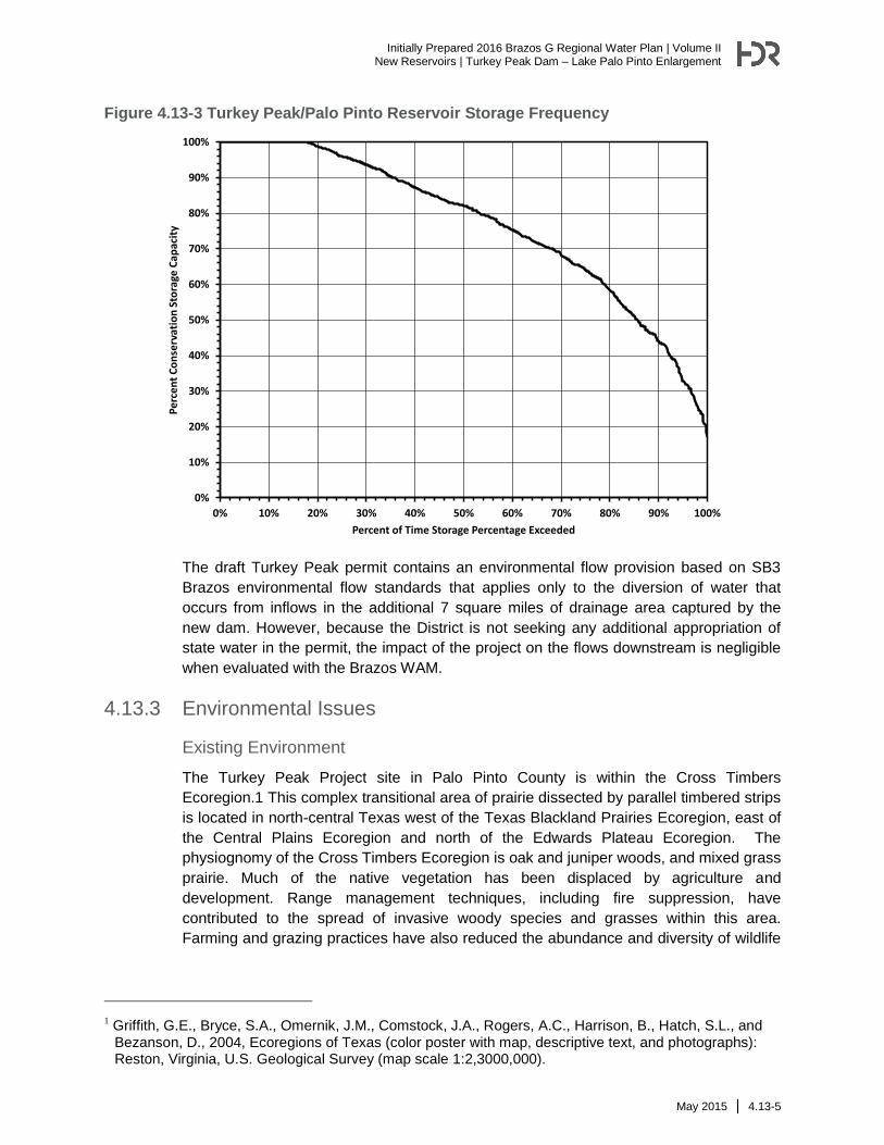
Initially Prepared 2016 Brazos G Regional Water Plan | Volume II New Reservoirs | Turkey Peak Dam – Lake Palo Pinto Enlargement May 2015 | 4.13-1 4.13 Turkey Peak Dam – Lake Palo Pinto Enlargement 4.13.1 Description of Option The Lake Palo Pinto dam was initially constructed in 1963 and 1964 with a conservation pool level of 863.0 feet above mean sea level (ft-msl) and deliberate impoundment began in April 1964. In 1966 the conservation storage level was raised four feet to 867.0 ft-msl. In the early 1980s, the Palo Pinto County Municipal Water District No. 1(District) became concerned about the capacity of Lake Palo Pinto and in 1985, a volumetric survey of Lake Palo Pinto was performed. This survey determined the reservoir’s conservation capacity to be 27,650 acft or about 63 percent of its authorized storage. In 2007, an additional volumetric survey was performed by the Texas Water Development Board and this survey determined the reservoir’s capacity to be 27,215 acft (about 62 percent of its authorized storage of 44,100 acft). Based on the June 2007 TWDB survey, Lake Palo Pinto’s conservation pool currently inundates 2,176 acres at its conservation level and has an average depth of only 12.5 feet. The Turkey Peak Project project is currently being pursued by the District to recover the lost storage in Lake Palo Pinto as authorized under Certificate of Adjudication 12-4031. The proposed Turkey Peak Project is located on Palo Pinto Creek immediately downstream of Lake Palo Pinto, as shown in Figure 4.13-1. The proposed reservoir is located approximately 2 miles northwest of the City of Santo, just upstream from the bridge over Palo Pinto Creek on FM4. The conservation capacity of Turkey Peak Project is 22,577 acft and covers 648 acres, resulting in an average reservoir depth of 35 ft. The normal pool elevation of the Turkey Peak Project will be 867 ft-msl, the same as Lake Palo Pinto. A portion of the existing dam and spillway at Lake Palo Pinto will be removed and the two reservoir pools will be connected above an elevation of 863 ft-msl. Below this elevation a pipe will connect both pools as shown in Figure and the two pools can be operated either as a single reservoir or as separate reservoirs. The combined Turkey Peak/Palo Pinto Reservoir will initially contain approximately 49,792 acft of conservation storage and inundate 2,824 acres at its conservation storage level of 867 ft- msl.
Transcript
Initially Prepared 2016 Brazos G Regional Water Plan | Volume II
New Reservoirs | Turkey Peak Dam – Lake Palo Pinto Enlargement
May 2015 | 4.13-1
4.13 Turkey Peak Dam – Lake Palo Pinto Enlargement
4.13.1 Description of Option
The Lake Palo Pinto dam was initially constructed in 1963 and 1964 with a conservation
pool level of 863.0 feet above mean sea level (ft-msl) and deliberate impoundment
began in April 1964. In 1966 the conservation storage level was raised four feet to 867.0
ft-msl. In the early 1980s, the Palo Pinto County Municipal Water District No. 1(District)
became concerned about the capacity of Lake Palo Pinto and in 1985, a volumetric
survey of Lake Palo Pinto was performed. This survey determined the reservoir’s
conservation capacity to be 27,650 acft or about 63 percent of its authorized storage. In
2007, an additional volumetric survey was performed by the Texas Water Development
Board and this survey determined the reservoir’s capacity to be 27,215 acft (about 62
percent of its authorized storage of 44,100 acft). Based on the June 2007 TWDB survey,
Lake Palo Pinto’s conservation pool currently inundates 2,176 acres at its conservation
level and has an average depth of only 12.5 feet. The Turkey Peak Project project is
currently being pursued by the District to recover the lost storage in Lake Palo Pinto as
authorized under Certificate of Adjudication 12-4031.
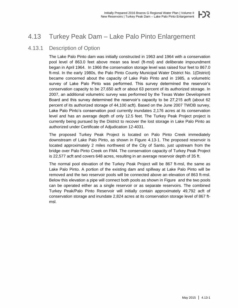
The proposed Turkey Peak Project is located on Palo Pinto Creek immediately
downstream of Lake Palo Pinto, as shown in Figure 4.13-1. The proposed reservoir is
located approximately 2 miles northwest of the City of Santo, just upstream from the
bridge over Palo Pinto Creek on FM4. The conservation capacity of Turkey Peak Project
is 22,577 acft and covers 648 acres, resulting in an average reservoir depth of 35 ft.
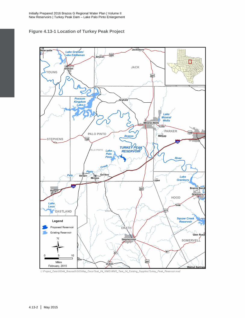
The normal pool elevation of the Turkey Peak Project will be 867 ft-msl, the same as
Lake Palo Pinto. A portion of the existing dam and spillway at Lake Palo Pinto will be
removed and the two reservoir pools will be connected above an elevation of 863 ft-msl.
Below this elevation a pipe will connect both pools as shown in Figure and the two pools
can be operated either as a single reservoir or as separate reservoirs. The combined
Turkey Peak/Palo Pinto Reservoir will initially contain approximately 49,792 acft of
conservation storage and inundate 2,824 acres at its conservation storage level of 867 ft-
msl.
Initially Prepared 2016 Brazos G Regional Water Plan | Volume II New Reservoirs | Turkey Peak Dam – Lake Palo Pinto Enlargement
4.13-2 | May 2015
Figure 4.13-1 Location of Turkey Peak Project
Initially Prepared 2016 Brazos G Regional Water Plan | Volume II
New Reservoirs | Turkey Peak Dam – Lake Palo Pinto Enlargement
2 Telfair, R.C., “Texas Wildlife Resources and Land Uses,” University of Texas Press, Austin, Texas, 1999.
3 Larkin, T.J., and G.W. Bomar, “Climatic Atlas of Texas,” Texas Department of Water Resources, Austin, Texas, 1983.
4 Texas Water Development Board (TWDB), Major and Minor Aquifers of Texas; Maps online at http://www.twdb.state.tx.us/mapping/index.asp, 2004.
5 Kier, R.S., L.E. Garner, and L.F. Brown, Jr., “Land Resources of Texas.” Bureau of Economic Geology, University of Texas, Austin, Texas, 1977.
6 Moore, J.D., Soil Survey of Palo Pinto County, Texas, United States Department of Agriculture, Soil Conservation Service, in cooperation with Texas Agricultural Experiment Station, 1981.
7 McMahan, C.A., R.F. Frye, and K.L. Brown, “The Vegetation Types of Texas,” Texas Parks and Wildlife Department, Wildlife Division, Austin, Texas, 1984.
According to TPWD geographic information system (GIS) data, 84 percent of the habitat
which will be inundated by the project includes forest or woodland areas, 6 percent is
grassland, approximately 4 percent is shrubland, and the remaining 6 percent includes
herbaceous vegetation, open water and urban areas.12
Cultural Resources
Cultural resources protection on public lands in Texas is afforded by the Antiquities Code
of Texas (Title 9, Chapter 191, Texas Natural Resource Code of 1977), the National
11 Blair, W. Frank. 1950. “The Biotic Provinces of Texas,” Texas Journal of Science 2 (1):93-117, modified by TPWD GIS lab.
12 TPWD. 2014. Texas Ecological Systems GIS mapping layers.
Initially Prepared 2016 Brazos G Regional Water Plan | Volume II
New Reservoirs | Turkey Peak Dam – Lake Palo Pinto Enlargement
May 2015 | 4.13-11
Historic Preservation Act (Pl96-515), and the Archeological and Historic Preservation Act
(PL93-291). Based on the review of available GIS datasets provided by the Texas
Historical Commission (THC), there are no National Register Properties, National
Register Districts, State Historic Sites, cemeteries or historical markers located within or
near the reservoir project area. The owner or controller of the project would be required
to coordinate with the Texas Historical Commission regarding potential impacts to
cultural resources.
The Texas Archeological Sites Atlas online database of the Texas Historical Commission
(THC) was also consulted and background research was conducted to determine any
previous cultural resources survey efforts as well as the locations of previously recorded
historic and archaeological resources in the project area. Records indicate that eight
previously recorded prehistoric archaeological sites were located within a 1-mile radius of
the reservoir area.
In addition a Phase IA cultural resource assessment was conducted for the proposed
development of the Turkey Peak Project site in January 2009. This research revealed
that there were no previously documented archeological sites found within the proposed
reservoir area. Phase 1B surveys, including trenching at selected alluvial terrace
locations, were initiated in 2010. The findings of the Phase 1B surveys were provided to
the USACE and THC in support of Section 404 Permit coordination in accordance with
the requirements of Section 106 of the National Historic Preservation Act (NHPA). The
District will also coordinate the findings of the archeological surveys with the THC and
TCEQ in conjunction with the review of the project under the Antiquities Code of Texas.
The Phase 1B investigations recorded two prehistoric localities, 13 prehistoric sites, and
one historic site. Nine sites are recommended for further testing to determine eligibility
for listing in the National Register of Historic Places (NRHP) and designation as a State
Archeological Landmark (SAL). Five sites are recommended as not eligible for NRHP
listing or SAL designation. The evaluation of the pre-historic and historic resources in the
area of potential effect of the reservoir will be conducted and documented in accordance
with standard practices for determination of NRHP and SAL eligibility and mitigation
measures will be implemented, if necessary.
Threats to Natural Resources
The Turkey Peak Project will have little adverse effect on stream flow below the reservoir
site and will meet TCEQ environmental flow requirements included in the water rights
permit. In addition the reservoir would trap and/or dilute pollutants, providing some
positive benefits to water quality immediately downstream. Dissolved oxygen levels on
Palo Pinto Creek are expected to be slightly improved as the project includes plans to
construct a multi-level outlet tower which will always release water to Palo Pinto Creek
from the top 10 to 15 feet of the reservoir pool. Current conditions include an existing
outlet pipe at Lake Palo Pinto at a fixed elevation of 835 ft-msl which is 32 feet below
conservation level. The project is expected to have negligible impacts to total discharge
downstream and overall water quality in the Brazos River or Brazos River estuary.
Initially Prepared 2016 Brazos G Regional Water Plan | Volume II New Reservoirs | Turkey Peak Dam – Lake Palo Pinto Enlargement
4.13-12 | May 2015
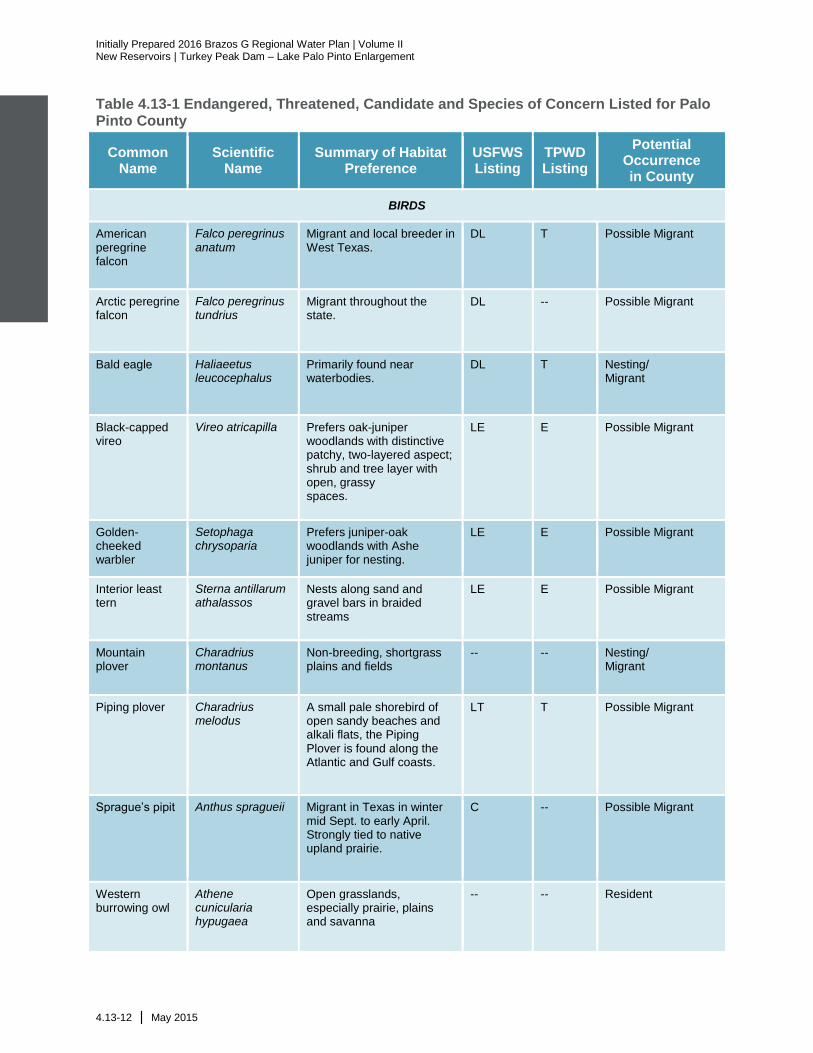
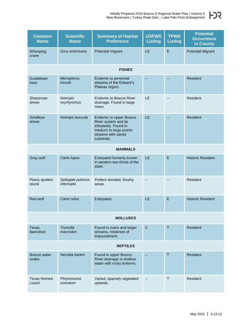
Table 4.13-1 Endangered, Threatened, Candidate and Species of Concern Listed for Palo Pinto County
Common Name
Scientific Name
Summary of Habitat Preference
USFWS Listing
TPWD Listing
Potential Occurrence in County
BIRDS
American peregrine falcon
Falco peregrinus anatum
Migrant and local breeder in West Texas.
DL T Possible Migrant
Arctic peregrine falcon
Falco peregrinus tundrius
Migrant throughout the state.
DL -- Possible Migrant
Bald eagle Haliaeetus leucocephalus
Primarily found near waterbodies.
DL T Nesting/ Migrant
Black-capped vireo
Vireo atricapilla Prefers oak-juniper woodlands with distinctive patchy, two-layered aspect; shrub and tree layer with open, grassy spaces.
LE E Possible Migrant
Golden-cheeked warbler
Setophaga chrysoparia
Prefers juniper-oak woodlands with Ashe juniper for nesting.
LE E Possible Migrant
Interior least tern
Sterna antillarum athalassos
Nests along sand and gravel bars in braided streams
LE E Possible Migrant
Mountain plover
Charadrius montanus
Non-breeding, shortgrass plains and fields
-- -- Nesting/ Migrant
Piping plover Charadrius melodus
A small pale shorebird of open sandy beaches and alkali flats, the Piping Plover is found along the Atlantic and Gulf coasts.
LT T Possible Migrant
Sprague’s pipit Anthus spragueii Migrant in Texas in winter mid Sept. to early April. Strongly tied to native upland prairie.
C -- Possible Migrant
Western burrowing owl
Athene cunicularia hypugaea
Open grasslands, especially prairie, plains and savanna
-- -- Resident
Initially Prepared 2016 Brazos G Regional Water Plan | Volume II
New Reservoirs | Turkey Peak Dam – Lake Palo Pinto Enlargement
May 2015 | 4.13-13
Common Name
Scientific Name
Summary of Habitat Preference
USFWS Listing
TPWD Listing
Potential Occurrence in County
Whooping crane
Grus americana Potential migrant LE E Potential Migrant
FISHES
Guadalupe bass
Micropterus treculii
Endemic to perennial streams of the Edward’s Plateau region.
-- -- Resident
Sharpnose shiner
Notropis oxyrhynchus
Endemic to Brazos River drainage. Found in large rivers.
LE -- Resident
Smalleye shiner
Notropis buccula Endemic to upper Brazos River system and its tributaries. Found in medium to large prairie streams with sandy substrate.
LE -- Resident
MAMMALS
Gray wolf Canis lupus Extirpated formerly known in western two-thirds of the state.
LE E Historic Resident
Plains spotted skunk
Spilogale putorius interrupta
Prefers wooded, brushy areas.
-- -- Resident
Red wolf Canis rufus Extirpated. LE E Historic Resident
MOLLUSKS
Texas fawnsfoot
Truncilla macrodon
Found in rivers and larger streams, intolerant of impoundment.
C T Resident
REPTILES
Brazos water snake
Nerodia harteri Found in upper Brazos River drainage in shallow water with rocky bottoms.
-- T Resident
Texas Horned Lizard
Phrynosoma cornutum
Varied, sparsely vegetated uplands.
-- T Resident
Initially Prepared 2016 Brazos G Regional Water Plan | Volume II New Reservoirs | Turkey Peak Dam – Lake Palo Pinto Enlargement
4.13-14 | May 2015
Common Name
Scientific Name
Summary of Habitat Preference
USFWS Listing
TPWD Listing
Potential Occurrence in County
LE/LT=Federally Listed Endangered/Threatened DL=Federally Delisted C=Candidate for Federal Listing PT=Proposed Threatened E, T=State Listed Endangered/Threatened Blank = Considered rare, but no regulatory listing status
TPWD, 2015. Annotated County List of Rare Species –Palo Pinto County 9/4/2014. USFWS, 2015. Endangered Species List for Palo Pinto County, Texas. At http://ecos.fws.gov/tess_public/countySearch!speciesByCountyReport.action, February 19, 2015.
4.13.4 Engineering and Costing
Cost estimates for the Turkey Peak/Palo Pinto Reservoir were originally prepared by
HDR, Inc. in 2013 as part of a preliminary design study and those costs were updated for
this study to reflect current September 2013 costs. The capital cost, approximately $48.3
million, are associated with the relocation of FM 4, the construction of a new bridge and
road at the existing dam and spillway at Lake Palo Pinto and the construction of the new
dam and spillways along with modifications to the existing dam and spillway. The total
project cost is approximately $91.4 million (Table 4.13-2). This includes the costs for
construction, land acquisition, resolution of conflicts, environmental permitting and
mitigation, engineering, mapping and surveying, utility relocations, design, TxDOT plan
review, and construction phase services. However, the District has already financed
approximately $8 million in preliminary engineering studies and legal assistance
associated with permit acquisitions. Therefore, the total remaining project costs are
estimated to be $83.4 million. The 6-month safe yield of 8,100 acft/yr from the project
would provide raw water to the District at a unit cost of $749 per acft or $2.30 per 1,000
gallons.
Initially Prepared 2016 Brazos G Regional Water Plan | Volume II
New Reservoirs | Turkey Peak Dam – Lake Palo Pinto Enlargement
May 2015 | 4.13-15
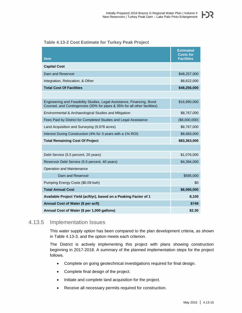
Table 4.13-2 Cost Estimate for Turkey Peak Project
Item
Estimated Costs for Facilities
Capital Cost
Dam and Reservoir $48,257,000
Integration, Relocation, & Other $8,622,000
Total Cost Of Facilities $48,256,000
Engineering and Feasibility Studies, Legal Assistance, Financing, Bond Counsel, and Contingencies (30% for pipes & 35% for all other facilities)
$16,890,000
Environmental & Archaeological Studies and Mitigation $8,767,000
Fees Paid by District for Completed Studies and Legal Assistance ($8,000,000)
Land Acquisition and Surveying (9,978 acres) $8,767,000
Interest During Construction (4% for 3 years with a 1% ROI) $8,683,000
Total Remaining Cost Of Project $83,363,000
Debt Service (5.5 percent, 20 years) $1,076,000
Reservoir Debt Service (5.5 percent, 40 years) $4,394,000
Operation and Maintenance
Dam and Reservoir $595,000
Pumping Energy Costs ($0.09 kwh) $0
Total Annual Cost $6,065,000
Available Project Yield (acft/yr), based on a Peaking Factor of 1 8,100
Annual Cost of Water ($ per acft) $749
Annual Cost of Water ($ per 1,000 gallons) $2.30
4.13.5 Implementation Issues
This water supply option has been compared to the plan development criteria, as shown
in Table 4.13-3, and the option meets each criterion.
The District is actively implementing this project with plans showing construction
beginning in 2017-2018. A summary of the planned implementation steps for the project
follows.
Complete on going geotechnical investigations required for final design.
Complete final design of the project.
Initiate and complete land acquisition for the project.
Receive all necessary permits required for construction.
Initially Prepared 2016 Brazos G Regional Water Plan | Volume II New Reservoirs | Turkey Peak Dam – Lake Palo Pinto Enlargement
4.13-16 | May 2015
Secure additional state funding to implement the project.
Begin construction of the project.
Potential Regulatory Requirements:
Finalize the Texas Commission on Environmental Quality Water Right and
Storage permits;
Finalize the U.S. Army Corps of Engineers Permit for discharges of dredge or fill
into wetlands and waters of the U.S. for dam construction, and other activities
(Section 404 of the Clean Water Act);
Texas Commission on Environmental Quality administered Texas Pollutant
Discharge Elimination System Storm Water Pollution Prevention Plan;
Texas General Land Office Easement if State-owned land or water is involved;
and
Texas Parks and Wildlife Department Sand, Shell, Gravel and Marl permit if
state-owned streambed is involved.
State and Federal Permits may require the following studies and plans:
Environmental impact or assessment studies;
Wildlife habitat mitigation plan that may require acquisition and management of
additional land;
Flow releases downstream to maintain aquatic ecosystems;
Assessment of impacts on Federal- and State-listed endangered and threatened
species; and
Cultural resources studies to determine resources impacts and appropriate
mitigation plan that may include cultural resource recovery and cataloging;
requires coordination with the Texas Historical Commission.
Land Acquisition Issues:
Land acquired for reservoir and/or mitigation plans could include market
transactions or other local landowner agreements;
Additional acquisition of rights-of-way and/or easements may be required; and
Possible relocations or removal of residences, utilities, roads, or other structures.
Initially Prepared 2016 Brazos G Regional Water Plan | Volume II
New Reservoirs | Turkey Peak Dam – Lake Palo Pinto Enlargement
May 2015 | 4.13-17
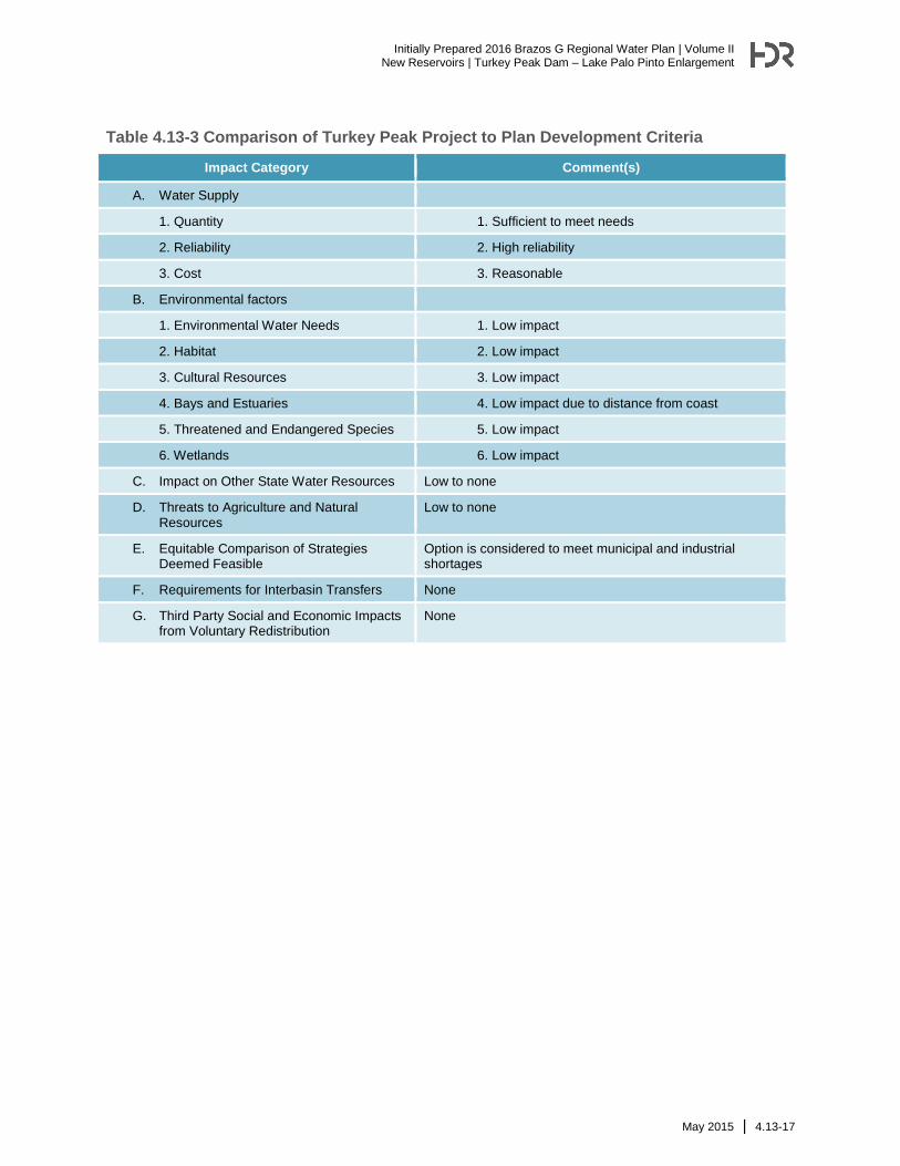
Table 4.13-3 Comparison of Turkey Peak Project to Plan Development Criteria
Impact Category Comment(s)
A. Water Supply
1. Quantity 1. Sufficient to meet needs
2. Reliability 2. High reliability
3. Cost 3. Reasonable
B. Environmental factors
1. Environmental Water Needs 1. Low impact
2. Habitat 2. Low impact
3. Cultural Resources 3. Low impact
4. Bays and Estuaries 4. Low impact due to distance from coast
5. Threatened and Endangered Species 5. Low impact
6. Wetlands 6. Low impact
C. Impact on Other State Water Resources Low to none
D. Threats to Agriculture and Natural Resources
Low to none
E. Equitable Comparison of Strategies Deemed Feasible
Option is considered to meet municipal and industrial shortages
F. Requirements for Interbasin Transfers None
G. Third Party Social and Economic Impacts from Voluntary Redistribution
None
Initially Prepared 2016 Brazos G Regional Water Plan | Volume II New Reservoirs | Turkey Peak Dam – Lake Palo Pinto Enlargement