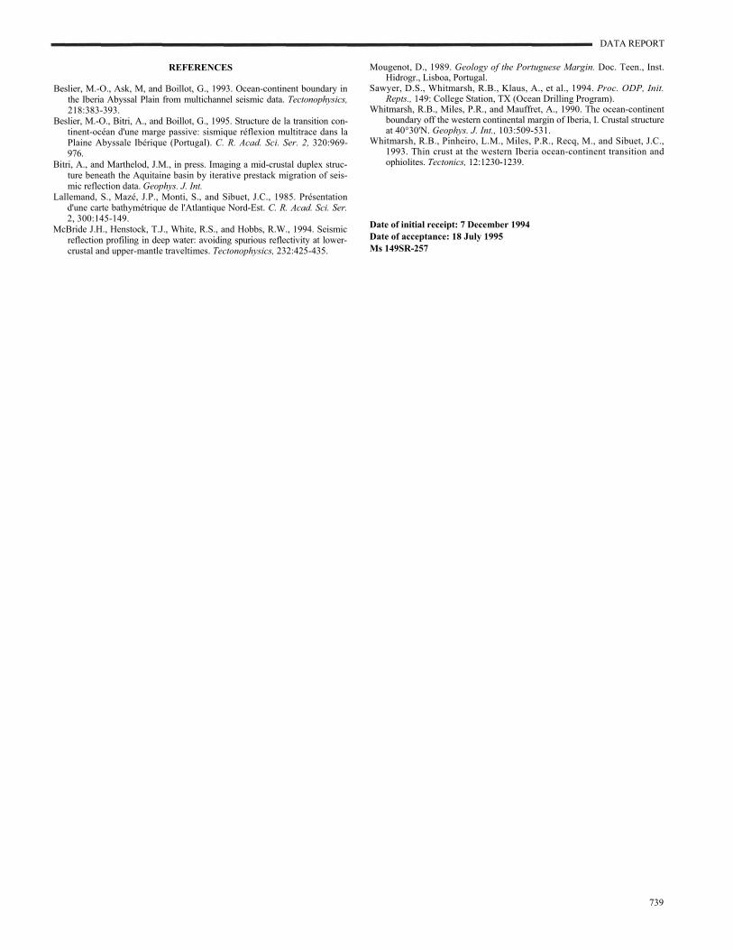
Whitmarsh, R.B., Sawyer, D.S., Klaus, A., and Masson, D.G. (Eds.), 1996 Proceedings of the Ocean Drilling Program, Scientific Results, Vol. 149 48. DATA REPORT: SEISMIC LINE LG12 IN THE IBERIA ABYSSAL PLAIN 1 Marie-Odile Beslier 2 INTRODUCTION Sites 898, 900, and 901 of Ocean Drilling Program Leg 149 are located on seismic line LG12, and Sites 897 and 899 are located just to the north of the line (Fig. 1). This paper presents the acquisition and processing parameters of the seismic data, as well as line LG12 (Fig. 2, in text and in back-pocket foldout). METHODS Seismic line LG12 was shot in 1990 during the Lusigal cruise, managed by the "Groupe d'Etude de la Marge Continentale" of Ville- franche-sur-Mer (chief scientist: Gilbert Boillot). The sound source was a two-line array of 8 water guns (1.28 L, or 80 in 3 each), shooting every 50 m. The data were acquired with a 96-channel, 2400-m-long AMG digital streamer with 25-m groups. The maximum offset was 2700 m. The data were recorded in SEG-D demultiplexed format with a 4-ms sampling rate and a recording window of 8 s. Standard processing of the seismic data was performed on a Per- kin Elmer computer using the GEOMAX software, and included the following steps: 1. Reformat the SEG-D data to GEOMAX format. 2. Edit the data in order to eliminate bad traces and noisy records. 3. Select every fourth trace from each shot gather. 4. Number the common midpoints (CMP) from acquisition sys- tem geometry. 5. Equalize amplitude to achieve spatial balance. 6. First break mute. 7. Sort to CMP gather. 8. Velocity analysis (coherency semblance and constant velocity stack). 9. Normal moveout correction. 10. 24-fold stack (CMP interval of 50 m). 11. F-K filter. 12. F-K time migration. 13. Time-varying bandpass filter (SP = shotpoints, TWT = two- way traveltime; bsf = below seafloor): Figure 1. Location of seismic line LG12 in the Iberia Abyssal Plain on a bathymetric map of the West Iberia Margin (bathymetry from Lallemand et al., 1985). Sections a, b, and c are presented in Figure 2 in text and in the foldout included in the back pocket of this volume. The peridotite ridge is outlined by a gray shaded line, and locations of Sites 897-901 of Leg 149 are shown. On the Galicia deep margin, solid circles are ODP Leg 103 sites, and solid squares are diving sites of the Galinaute cruise. Linear interpolation of the filter is applied between each window limit. 14. Time-varying amplitude gain control (AGC): 1 Whitmarsh, R.B., Sawyer, D.S., Klaus, A., and Masson, D.G. (Eds.), 1996. Proc. ODP, Sci. Results, 149: College Station, TX (Ocean Drilling Program). 2 Laboratoire de Géodynamique Sous-Marine, B.P. 48, F-06230 Villefranche-sur- Mer, France. [email protected]The short section (d) shown on Figure 1 is a prestack depth migra- tion (CMP interval of 25 m; for details on the method, see Bitri and Marthelod, in press). A prestack depth migration of a longer part of the line, covering the drilling Sites 898, 900, and 901, is presented in Krawczyk et al. (this volume). 737 Reproduced online: 24 September 2004.
Transcript
Whitmarsh, R.B., Sawyer, D.S., Klaus, A., and Masson, D.G. (Eds.), 1996 Proceedings of the Ocean Drilling Program, Scientific Results, Vol. 149
48. DATA REPORT: SEISMIC LINE LG12 IN THE IBERIA ABYSSAL PLAIN1
Marie-Odile Beslier2
INTRODUCTION
Sites 898, 900, and 901 of Ocean Drilling Program Leg 149 are located on seismic line LG12, and Sites 897 and 899 are located just to the north of the line (Fig. 1). This paper presents the acquisition and processing parameters of the seismic data, as well as line LG12 (Fig. 2, in text and in back-pocket foldout).
METHODS
Seismic line LG12 was shot in 1990 during the Lusigal cruise, managed by the "Groupe d'Etude de la Marge Continentale" of Ville- franche-sur-Mer (chief scientist: Gilbert Boillot). The sound source was a two-line array of 8 water guns (1.28 L, or 80 in3 each), shooting every 50 m. The data were acquired with a 96-channel, 2400-m-long AMG digital streamer with 25-m groups. The maximum offset was 2700 m. The data were recorded in SEG-D demultiplexed format with a 4-ms sampling rate and a recording window of 8 s.
Standard processing of the seismic data was performed on a Per- kin Elmer computer using the GEOMAX software, and included the following steps:
1. Reformat the SEG-D data to GEOMAX format. 2. Edit the data in order to eliminate bad traces and noisy records. 3. Select every fourth trace from each shot gather. 4. Number the common midpoints (CMP) from acquisition sys-
tem geometry. 5. Equalize amplitude to achieve spatial balance. 6. First break mute. 7. Sort to CMP gather. 8. Velocity analysis (coherency semblance and constant velocity
stack). 9. Normal moveout correction.
10. 24-fold stack (CMP interval of 50 m). 11. F-K filter. 12. F-K time migration. 13. Time-varying bandpass filter (SP = shotpoints, TWT = two-
way traveltime; bsf = below seafloor):
Linear interpolation of the filter is applied between each window limit.
1Whitmarsh, R.B., Sawyer, D.S., Klaus, A., and Masson, D.G. (Eds.), 1996. Proc. ODP, Sci. Results, 149: College Station, TX (Ocean Drilling Program).
2Laboratoire de Géodynamique Sous-Marine, B.P. 48, F-06230 Villefranche-sur- Mer, France. [email protected]
Reproduced online: 24 September 2004.
Figure 1. Location of seismic line LG12 in the Iberia Abyssal Plain on a bathymetric map of the West Iberia Margin (bathymetry from Lallemand et al., 1985). Sections a, b, and c are presented in Figure 2 in text and in the foldout included in the back pocket of this volume. The peridotite ridge is outlined by a gray shaded line, and locations of Sites 897-901 of Leg 149 are shown. On the Galicia deep margin, solid circles are ODP Leg 103 sites, and solid squares are diving sites of the Galinaute cruise.
14. Time-varying amplitude gain control (AGC):
The short section (d) shown on Figure 1 is a prestack depth migra- tion (CMP interval of 25 m; for details on the method, see Bitri and Marthelod, in press). A prestack depth migration of a longer part of the line, covering the drilling Sites 898, 900, and 901, is presented in Krawczyk et al. (this volume).
737
DATA REPORT
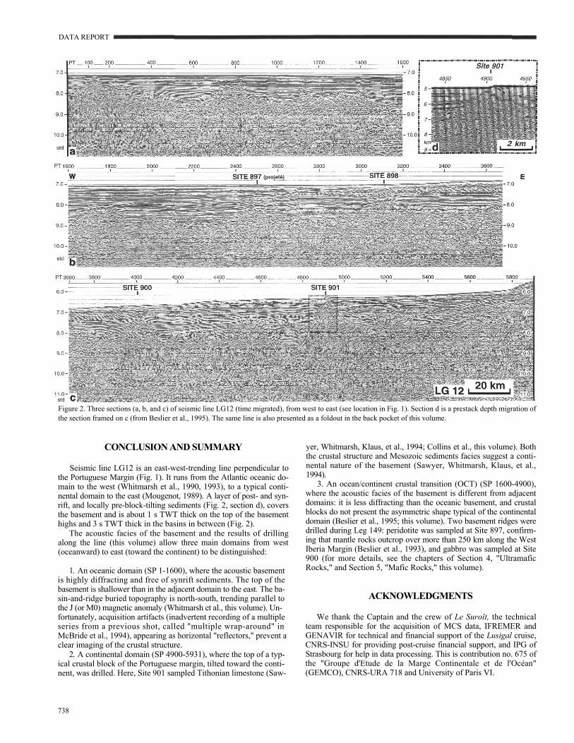
Figure 2. Three sections (a, b, and c) of seismic line LG12 (time migrated), from west to east (see location in Fig. 1). Section d is a prestack depth migration of the section framed on c (from Beslier et al., 1995). The same line is also presented as a foldout in the back pocket of this volume.
CONCLUSION AND SUMMARY
Seismic line LG12 is an east-west-trending line perpendicular to the Portuguese Margin (Fig. 1). It runs from the Atlantic oceanic do- main to the west (Whitmarsh et al., 1990, 1993), to a typical conti- nental domain to the east (Mougenot, 1989). A layer of post- and syn- rift, and locally pre-block-tilting sediments (Fig. 2, section d), covers the basement and is about 1 s TWT thick on the top of the basement highs and 3 s TWT thick in the basins in between (Fig. 2).
The acoustic facies of the basement and the results of drilling along the line (this volume) allow three main domains from west (oceanward) to east (toward the continent) to be distinguished:
1. An oceanic domain (SP 1-1600), where the acoustic basement is highly diffracting and free of synrift sediments. The top of the basement is shallower than in the adjacent domain to the east. The ba- sin-and-ridge buried topography is north-south, trending parallel to the J (or M0) magnetic anomaly (Whitmarsh et al., this volume). Un- fortunately, acquisition artifacts (inadvertent recording of a multiple series from a previous shot, called "multiple wrap-around" in McBride et al., 1994), appearing as horizontal "reflectors," prevent a clear imaging of the crustal structure.
2. A continental domain (SP 4900-5931), where the top of a typ- ical crustal block of the Portuguese margin, tilted toward the conti- nent, was drilled. Here, Site 901 sampled Tithonian limestone (Saw-
738
yer, Whitmarsh, Klaus, et al., 1994; Collins et al., this volume). Both the crustal structure and Mesozoic sediments facies suggest a conti- nental nature of the basement (Sawyer, Whitmarsh, Klaus, et al., 1994).
3. An ocean/continent crustal transition (OCT) (SP 1600-4900), where the acoustic facies of the basement is different from adjacent domains: it is less diffracting than the oceanic basement, and crustal blocks do not present the asymmetric shape typical of the continental domain (Beslier et al., 1995; this volume). Two basement ridges were drilled during Leg 149: peridotite was sampled at Site 897, confirm- ing that mantle rocks outcrop over more than 250 km along the West Iberia Margin (Beslier et al., 1993), and gabbro was sampled at Site 900 (for more details, see the chapters of Section 4, "Ultramafic Rocks," and Section 5, "Mafic Rocks," this volume).
ACKNOWLEDGMENTS
We thank the Captain and the crew of Le Suroît, the technical team responsible for the acquisition of MCS data, IFREMER and GENAVIR for technical and financial support of the Lusigal cruise, CNRS-INSU for providing post-cruise financial support, and IPG of Strasbourg for help in data processing. This is contribution no. 675 of the "Groupe d'Etude de la Marge Continentale et de l'Océan" (GEMCO), CNRS-URA 718 and University of Paris VI.
DATA REPORT
REFERENCES
Beslier, M.-O., Ask, M, and Boillot, G., 1993. Ocean-continent boundary in the Iberia Abyssal Plain from multichannel seismic data. Tectonophysics, 218:383-393.
Beslier, M.-O., Bitri, A., and Boillot, G., 1995. Structure de la transition con- tinent-océan d'une marge passive: sismique réflexion multitrace dans la Plaine Abyssale Ibérique (Portugal). C. R. Acad. Sci. Ser. 2, 320:969- 976.
Bitri, A., and Marthelod, J.M., in press. Imaging a mid-crustal duplex struc- ture beneath the Aquitaine basin by iterative prestack migration of seis- mic reflection data. Geophys. J. Int.
Lallemand, S., Mazé, J.P., Monti, S., and Sibuet, J.C., 1985. Présentation d'une carte bathymétrique de l'Atlantique Nord-Est. C. R. Acad. Sci. Ser. 2, 300:145-149.
McBride J.H., Henstock, T.J., White, R.S., and Hobbs, R.W., 1994. Seismic reflection profiling in deep water: avoiding spurious reflectivity at lower- crustal and upper-mantle traveltimes. Tectonophysics, 232:425-435.
Mougenot, D., 1989. Geology of the Portuguese Margin. Doc. Teen., Inst. Hidrogr., Lisboa, Portugal.
Sawyer, D.S., Whitmarsh, R.B., Klaus, A., et al., 1994. Proc. ODP, Init. Repts., 149: College Station, TX (Ocean Drilling Program).
Whitmarsh, R.B., Miles, P.R., and Mauffret, A., 1990. The ocean-continent boundary off the western continental margin of Iberia, I. Crustal structure at 40°30'N. Geophys. J. Int., 103:509-531.
Whitmarsh, R.B., Pinheiro, L.M., Miles, P.R., Recq, M., and Sibuet, J.C., 1993. Thin crust at the western Iberia ocean-continent transition and ophiolites. Tectonics, 12:1230-1239.
Date of initial receipt: 7 December 1994 Date of acceptance: 18 July 1995 Ms 149SR-257