SERRAMONTE SHOPPING CENTER EXPANSION PROJECT DRAFT EIR CITY OF DALY CITY HYDROLOGY AND WATER QUALITY PLACEWORKS 4.8-1 4.8 HYDROLOGY AND WATER QUALITY This chapter discusses the existing hydrology and water quality of the Project site and its surroundings, and evaluates the potential impacts to hydrology and water quality associated with development of the Project. A Water Supply Assessment (WSA) is included in Appendix G of this Draft EIR. ENVIRONMENTAL SETTING 4.8.1 REGULATORY FRAMEWORK 4.8.1.1 Federal Regulations Clean Water Act The Federal Water Pollution Control Act, also known as the Clean Water Act (CWA), is the primary statute governing water quality. The CWA establishes the basic structure for regulating the discharges of pollutants into the waters of the United States and gives the US Environmental Protection Agency (EPA) the authority to implement pollution control programs. The statute’s goal is to regulate all discharges into the nation’s waters and to restore, maintain, and preserve the integrity of those waters. The CWA sets water quality standards for all contaminants in surface waters and mandates permits for wastewater and stormwater discharges. The CWA also requires states to establish site-specific water quality standards for navigable bodies of water and regulates other activities that affect water quality, such as the dredging and filling of wetlands. The following CWA sections assist in ensuring water quality for the waters of the US: CWA Section 208 requires the use of best management practices (BMPs) to control the discharge of pollutants in stormwater during construction. CWA Section 303(d) requires the creation of a list of impaired water bodies by states, territories, and authorized tribes; evaluation of lawful activities that may impact impaired water bodies, and preparation of plans to improve the quality of these water bodies. CWA Section 303(d) also establishes Total Maximum Daily Loads (TMDLs), which is the maximum amount of a pollutant that a water body can receive and still safely meet water quality standards. CWA Section 404 authorizes the US Army Corps of Engineers to require permits that will discharge dredge or fill materials into waters in the US, including wetlands. In California, the EPA has designated the State Water Resources Control Board (SWRCB) and its nine Regional Water Quality Control Boards (RWQCBs) with the authority to identify beneficial uses and adopt applicable water quality objectives.
Transcript
S E R R A M O N T E S H O P P I N G C E N T E R E X P A N S I O N P R O J E C T D R A F T E I R C I T Y O F D A L Y C I T Y
HYDROLOGY AND WATER QUALITY
P L A C E W O R K S 4.8-1
4.8 HYDROLOGY AND WATER QUALITY This chapter discusses the existing hydrology and water quality of the Project site and its surroundings, and evaluates the potential impacts to hydrology and water quality associated with development of the Project. A Water Supply Assessment (WSA) is included in Appendix G of this Draft EIR.
ENVIRONMENTAL SETTING 4.8.1
REGULATORY FRAMEWORK 4.8.1.1
Federal Regulations
Clean Water Act The Federal Water Pollution Control Act, also known as the Clean Water Act (CWA), is the primary statute governing water quality. The CWA establishes the basic structure for regulating the discharges of pollutants into the waters of the United States and gives the US Environmental Protection Agency (EPA) the authority to implement pollution control programs. The statute’s goal is to regulate all discharges into the nation’s waters and to restore, maintain, and preserve the integrity of those waters. The CWA sets water quality standards for all contaminants in surface waters and mandates permits for wastewater and stormwater discharges. The CWA also requires states to establish site-specific water quality standards for navigable bodies of water and regulates other activities that affect water quality, such as the dredging and filling of wetlands. The following CWA sections assist in ensuring water quality for the waters of the US:
CWA Section 208 requires the use of best management practices (BMPs) to control the discharge of pollutants in stormwater during construction.
CWA Section 303(d) requires the creation of a list of impaired water bodies by states, territories, and authorized tribes; evaluation of lawful activities that may impact impaired water bodies, and preparation of plans to improve the quality of these water bodies. CWA Section 303(d) also establishes Total Maximum Daily Loads (TMDLs), which is the maximum amount of a pollutant that a water body can receive and still safely meet water quality standards.
CWA Section 404 authorizes the US Army Corps of Engineers to require permits that will discharge dredge or fill materials into waters in the US, including wetlands.
In California, the EPA has designated the State Water Resources Control Board (SWRCB) and its nine Regional Water Quality Control Boards (RWQCBs) with the authority to identify beneficial uses and adopt applicable water quality objectives.
S E R R A M O N T E S H O P P I N G C E N T E R E X P A N S I O N P R O J E C T D R A F T E I R C I T Y O F D A L Y C I T Y
HYDROLOGY AND WATER QUALITY
4.8-2 M A R C H 2 0 1 5
National Pollutant Discharge Elimination System
The National Pollutant Discharge Elimination System (NPDES) permit program was established by the CWA to regulate municipal and industrial discharges to surface waters of the United States from their municipal separate storm sewer systems (MS4s). Federal NPDES permit regulations have been established for broad categories of discharges, including point-source municipal waste discharges and nonpoint-source stormwater runoff. NPDES permits generally identify effluent and receiving water limits on allowable concentrations and/or mass emissions of pollutants contained in the discharge; prohibitions on discharges not specifically allowed under the permit; and provisions that describe required actions by the discharger, including industrial pretreatment, pollution prevention, self-monitoring and other activities.
Under the NPDES Program, all facilities which discharge pollutants into waters of the US are required to obtain an NPDES permit. Requirements for storm water discharges are also regulated under this program. In California, the NPDES permit program is administered by the SWRCB through the nine RWQCBs. The City of Daly City lies within the jurisdiction of San Francisco RWQCB (Region 2) and is subject to the waste discharge requirements of the Municipal Regional Stormwater Permit, known as the MRP. This was established by Order No. R2-2009-0074 and NPDES Permit No. CAS612008, as amended by Order No. R2-2011-0083 in 2011. The San Mateo County permittees include San Mateo County, the San Mateo County Flood Control District, 15 cities, and 5 towns, including Daly City. The current Municipal Regional Stormwater Permit (MRP) will expire at the end of 2014 and a new permit is due to be reissued in 2015.
Under Provision C.3 of the MRP, the co-permittees use their planning authorities to include appropriate source control, site design, and stormwater treatment measures in development and redevelopment projects. Development or redevelopment projects that create and/or replace 5,000 or 10,000 square feet or more of impervious surface (depending on the project type) to implement low impact development (LID) techniques. The City of Daly City requires as a standard of condition for applicants to submit to the City a stormwater management plan (SWMP) that shows full compliance with the MRP.
State Regulations
Porter-Cologne Water Quality Act
The Porter-Cologne Water Quality Act (Water Code sections 13000 et seq.) is the basic water quality control law for California. Under this Act, the SWRCB has ultimate control over State water rights and water quality policy. The State is divided into nine regions related to water quality and quantity characteristics. The SWRCB, through its nine RWQCBs carries out the regulation, protection, and administration of water quality in each region. Each regional board is required to adopt a Water Quality Control Plan or Basin Plan that recognizes and reflects the regional differences in existing water quality, the beneficial uses of the region’s ground and surface water, and local water quality conditions and problems.
State Water Resources Control Board (SWRCB) and San Francisco Bay Regional Water Quality Control Board In California, the SWRCB has broad authority over water quality control issues for the State. The SWRCB is responsible for developing statewide water quality policy and exercises the powers delegated to the State by the federal government under the CWA. Other State agencies with jurisdiction over water quality regulation in California include the California
S E R R A M O N T E S H O P P I N G C E N T E R E X P A N S I O N P R O J E C T D R A F T E I R C I T Y O F D A L Y C I T Y
HYDROLOGY AND WATER QUALITY
P L A C E W O R K S 4.8-3
Department of Health Services (DHS) for drinking water regulations, the California Department of Pesticide Regulation, the California Department of Fish and Game (DFG), and the Office of Environmental Health and Hazard Assessment (OEHHA).
Regional authority for planning, permitting, and enforcement is delegated to the nine RWQCBs. The regional boards are required to formulate and adopt water quality control plans for all areas in the region and establish water quality objectives in the plans. The Project site and City of San Mateo is within the jurisdiction of the San Francisco Bay RWQCB (Region 2), which regulates surface water and groundwater quality in San Francisco Bay. The RWQCB’s jurisdiction includes all of the San Francisco Bay segments extending to the mouth of the Sacramento-San Joaquin Delta. The RWQCB addresses regionwide water quality issues through the creation and triennial update of the San Francisco Bay Basin Water Quality Control (Basin Plan). The Basin Plan was adopted in 1995 and amended most recently in July 2013. This Basin Plan designates beneficial uses, establishes water quality objectives, and provides implementation programs and policies to achieve those objectives.
SWRCB Construction General Permit
Construction activities that disturb one or more acres of land that could impact hydrologic resources must comply with the requirements of the SWRCB Construction General Permit (CGP) (2009-0009-DWQ) as amended by Order No. 2010-0014-DWQ. Under the terms of the permit, applicants must file Permit Registration Documents (PRDs) with the SWRCB prior to the start of construction. The PRDs include a Notice of Intent (NOI), risk assessment, site map, Storm Water Pollution Prevention Plan (SWPPP), annual fee, and a signed certification statement. The PRDs are now submitted electronically to the SWRCB via the Storm Water Multiple Application and Report Tracking System (SMARTS) website.
Applicants must also demonstrate conformance with applicable BMPs and prepare a SWPPP, containing a site map that shows the construction site perimeter, existing and proposed buildings, lots, roadways, stormwater collection and discharge points, general topography both before and after construction, and drainage patterns across the Project site. The SWPPP must list BMPs that would be implemented to prevent soil erosion and discharge of other construction-related pollutants that could contaminate nearby water resources. Additionally, the SWPPP must contain a visual monitoring program, a chemical monitoring program for nonvisible pollutants if there is a failure of the BMPs, and a sediment-monitoring plan if the site discharges directly to a water body listed on the 303(d) list for sediment. Some sites also require implementation of a Rain Event Action Plan (REAP). The updated CGP (2010-0014-DWQ), effective on September 2, 2012 also requires applicants to comply with post-construction runoff reduction requirements.
State Updated Model Water Efficient Landscape Ordinance (Assembly Bill 1881)
The updated Model Landscape Ordinance requires cities and counties to adopt landscape water conservation ordinances by January 31, 2010 or to adopt a different ordinance that is at least as effective in conserving water as the updated Model Water Efficient Landscape Ordinance (MWELO). The City of Daly City has adopted the Water Conservation in Landscaping Ordinance and revised the Daly City Municipal Code (Chapter 17.41) to meet this requirement.
S E R R A M O N T E S H O P P I N G C E N T E R E X P A N S I O N P R O J E C T D R A F T E I R C I T Y O F D A L Y C I T Y
HYDROLOGY AND WATER QUALITY
4.8-4 M A R C H 2 0 1 5
Local Regulations
San Mateo Countywide Water Pollution Prevention Program
The San Mateo Countywide Water Pollution Prevention Program (SMCWPPP) is a partnership of the City/County Association of Governments, 20 incorporated cities within the county, and the County of San Mateo, which share a common NPDES permit. This partnership also relies on each of the municipalities to implement local stormwater pollution prevention and control activities for its own local storm drain systems. The SMCWPPP’s Stormwater Management Plan (SWMP) outlines priorities, key elements, strategies, and evaluation methods to implement the SMCWPPP. The comprehensive program includes pollution reduction activities for construction sites, industrial sites, illegal discharges and illicit connections, new development, and municipal operations. The SWMP also includes a public education effort, target pollutant reduction strategies, and watershed assessment and monitoring. The SWMP, in conjunction with NPDES permit adopted by the Water Board, is designed to enable SMCWPPP to meet the requirements of the CWA. In addition to obtaining coverage under the State NPDES General Permit for construction activities, the Project would also be subject to coverage under the MRP, applicable to post-construction operations.
San Mateo County Flood Control District
The San Mateo County Flood Control District (SMCFCD) is a Countywide Special District, created by State legislation, to provide a mechanism to finance flood control projects. The legislation requires that a flood control zone be formed over an entire watershed and a proposed funding source be determined before a flood control project is undertaken. The City of Daly City and the Project site are within the Colma Creek Flood Control Zone, which was created in 1964 to construct flood control facilities in Colma Creek to alleviate flooding in the Colma Creek Watershed. Several channel improvements, bridge replacements, and culvert improvements have been implemented within Daly City as part of this Project. The SMCFCD is responsible for creeks, storm drain channels, walls, and levees that is owns and maintains within Daly City. Any proposed work involving the facilities that SMCFCD owns and maintains would require obtaining an encroachment permit.
Daly City General Plan
The Daly City General Plan contains goals, strategies, policies, and implementing actions that guide land use development within the City.1The General Plan policies and programs relevant to hydrology and water quality are listed in Table 4.8-1.
Daly City Municipal Code Four chapters of the Daly City Municipal Code contain directives pertaining to hydrology and water quality issues, as explained in the following paragraphs:
1 City of Daly City, 2013. Daly City 2030 General Plan. Adopted March 25, 2013.
S E R R A M O N T E S H O P P I N G C E N T E R E X P A N S I O N P R O J E C T D R A F T E I R C I T Y O F D A L Y C I T Y
HYDROLOGY AND WATER QUALITY
P L A C E W O R K S 4.8-5
TABLE 4.8-1 DALY CITY GENERAL PLAN POLICIES AND PROGRAMS RELEVANT TO HYDROLOGY AND WATER QUALITY
Program/Policy Number Program/Policy
Policy SE-2.1 Protect the City of Daly City from unreasonable risk to life and property caused by flood hazards by designing and constructing drainage facilities to improve the flow capacity of the City’s water system in order to accommodate the storm water runoff generated by a 100-year storm.
Policy SE-2.2 Reduce localized flooding through City funded drainage system improvements; seek alternate funding where possible.
Policy SE-2.3 Continue to require the habitable portions of new structures to have a finished flood elevation 1.5 feet above the projected 100-year water surface or to be adequately protected from flooding.
Policy SE-2.4 Prohibit any reduction of creek channel capacity, impoundment or diversion of creek channel flows which would adversely affect adjacent properties or the degree of flooding. Prevent erosion of creek banks.
Policy SE-2.5 Protect new development adjacent to creeks by requiring adequate building setbacks from creek banks and provision of access easements for creek maintenance purposes.
Program S-1 Grading and Erosion Control Ordinance – to minimize runoff from grading. Adopt ordinance which ensures that new construction, on-going businesses, and municipal maintenance will preserve storm water runoff which flows to the ocean and bay.
Program S-2 Implementation of Erosion Control Program – reduce hazards associated with soil erosion. Inspection and monitoring of construction activities to ensure compliance with the erosion and grading ordinance.
Policy RME-2 Require drought resistant landscaping and water conserving irrigation methods in new development, and encourage the replacement of existing water-intensive landscaping.
Policy RME-3 Continue to use recycled wastewater for irrigating and explore opportunities to expand capacity to accommodate its use in development projects, landscaped medians, golf courses, cemeteries, parks, and school playgrounds.
Policy RME-8
Through the development of a Stormwater Management Program, ensure that all new development complies with applicable Municipal Regional Stormwater NPDES Permit by incorporating controls that reduce water quality impacts over the life of the project in a way that is both technically and economically feasible, and reduces pollutants in stormwater discharges to the maximum extent practicable.
Policy RME-9 Balance stormwater mitigation measures with the other inherent benefits of higher density development that is in close proximity to public transit, i.e., reduction of Vehicle Miles Traveled (VMT) on local and regional roadways, to the extent permitted under the Municipal Regional Stormwater Permit.
Source: Daly City 2030 General Plan, 2013.
Chapter 13.20 – Well Standards
These standards are intended to ensure that groundwater beneath the City will not be polluted or contaminated. The chapter contains requirements for construction, reconstruction, repair and destruction of water wells, cathodic protection wells, and monitoring wells. Permits are also required for these activities as well as for excavations that may intersect groundwater.
Title 14 – Storm Water Management and Discharge Control
This title, also known as the “City of Daly City Storm Water Management and Discharge Control Ordinance”, contains provisions for eliminating non-stormwater discharges to the City’s storm drain system; controlling the discharge of spills, dumping, or disposal of materials other than stormwater; and reducing pollutants in stormwater discharges to the maximum extent practicable. These provisions meet the requirements of the CWA and MRP NPDES permit. The City has the authority to inspect properties to ensure that the provisions of this title are implemented, as per Chapter 14.12.
S E R R A M O N T E S H O P P I N G C E N T E R E X P A N S I O N P R O J E C T D R A F T E I R C I T Y O F D A L Y C I T Y
HYDROLOGY AND WATER QUALITY
4.8-6 M A R C H 2 0 1 5
Chapter 15.62 – Grading, Erosion, and Sediment Control
The purpose of this chapter, also known as the “City of Daly City Grading, Erosion and Sediment Control Ordinance”, sets forth rules and regulations to control site clearing, grading, and erosion control to protect water quality and minimize sediments and other pollutants from entering the City’s storm drain facilities. This requires projects to obtain a permit and prepare an erosion and sediment control plan that describes the surface runoff and erosion control measures that will be implemented during construction of the Project.
Chapter 17.41 – Water Conservation in Landscaping
The provisions of this chapter apply to all new construction and rehabilitated landscapes with irrigated landscape areas greater than 1,000 square feet. All applicants must complete a landscape project application and comply with the landscape and irrigation maintenance schedule requirements of this chapter. In addition, all owners of existing landscapes over 1 acre in size must comply with local agency programs related to irrigation audits, surveys, and water use analysis and maintain landscape irrigation facilities to prevent water waste and runoff.
EXISTING CONDITIONS 4.8.1.2
Climate and Precipitation
Daly City has a cool-summer Mediterranean climate with dry summers and mild, moist winters. The weather is moderated by the cool currents of the Pacific Ocean, which produces a mild year-round climate with little seasonal temperature variation. During the summer months, the City experiences cool winds and coastal fog, similar to its neighbor to the north, San Francisco. The average minimum temperature in January is 42 degrees Fahrenheit (°F) and the average maximum temperature in July is 71°F. Average annual precipitation for Daly City is about 20 inches, falling primarily between the months of October and April.
Topography
The topography within the footprint of the shopping center is relatively flat, with a gentle prevailing slope toward the east in the area west of the existing structure and a gentle slope toward the north in the area south of the existing structure.2 However, there are steep slopes in the southwest corner of the property. The surrounding area consists of gently rolling terrain. Ground surface elevations at the Project site generally range from 280 to 287 feet above mean sea level (msl), with an increase to about 400 feet msl in the southwest corner of the site.
Watershed and Regional Drainage
A watershed is the geographic area draining into a river system, ocean, or other body of water through a single outlet and includes the receiving waters. The Project lies within the Colma Creek Watershed, which encompasses approximately
2 BFK, 2013. A.L.T.A./A.C.S.M. Land Title Survey, Daly City Serramonte Center, LLC.
S E R R A M O N T E S H O P P I N G C E N T E R E X P A N S I O N P R O J E C T D R A F T E I R C I T Y O F D A L Y C I T Y
HYDROLOGY AND WATER QUALITY
P L A C E W O R K S 4.8-7
15.7 square miles.3 The watershed consists of 2.7 miles of unmodified channels, 7.1 miles of engineered channels, and 50 miles of underground culverts and storm drains. Colma Creek originates at the foot of San Bruno Mountain and flows southwest and then southeast through Daly City, Colma, and South San Francisco before discharging into San Francisco Bay just north of the San Francisco Airport. Within the valley portion of the watershed, Colma Creek is an open, concrete-lined engineered channel from the Colma/South San Francisco city limits to San Francisco Bay. This engineered section of creek is maintained by the SMCFCD. Most of the area upstream of South San Francisco flows through underground storm drains. Some of the uppermost reaches of the creek near San Bruno Mountain are natural channels. A small tributary of Colma Creek is located south of the Project site and flows from west to east before joining Colma Creek near El Camino Real and Collins Avenue. Figure 4.8-1 shows the project site and the Colma Creek Watershed.
Local Drainage
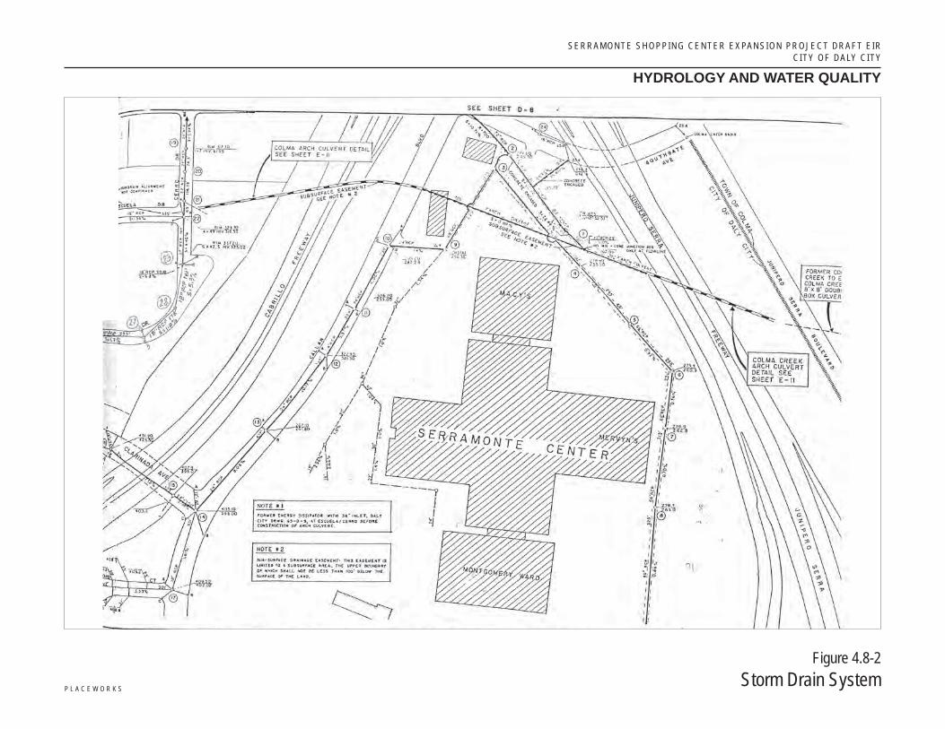
The Project site and surrounding area is currently served by the City’s storm drain system, which is maintained by the Daly City Public Works Department. Existing storm water runoff from the Project area is directed to catch basins within the site. The catch basins connect to on-site storm drains west of the buildings that range in size from 15 inches to 36 inches before connecting to the City’s 48-inch reinforced concrete pipe (RCP) in the northeast corner of the property. This 48-inch RCP subsequently connects to the Colma Creek Arch Culvert. On the east side of the shopping center, storm drains connect to the City’s 66-inch storm drain, which is maintained in a 20-foot-wide easement. The 66-inch RCP is aligned to the northwest just past the JCPenney’s building and expands to a 72-inch RCP that eventually discharges into the 7-foot Colma Creek Arch Culvert. Figure 4.8-2 shows the storm drain layout of the Shopping Center.
The Project involves redevelopment and expansion of the existing 883,000-square-foot Serramonte Shopping Center over a time period of 10 years to accommodate additional retail, restaurant, office space, a hotel, and medical offices. In its current configuration, the site is essentially 100 percent impervious as it is entirely covered by buildings and paved parking lots. Therefore, post-development stormwater runoff rates should not be significantly different from pre-development rates. However, because the Project must comply with the SMCWPPP C.3 provisions, which require the implementation of LID and BMP control measures, the amount of stormwater runoff would actually decrease with the proposed expansion. A new occupant of the Shopping Center (Dick’s Sporting Goods) was required to install five separate bioretention areas that receive surface flow from the surrounding parking lot. All new construction would require similar stormwater treatment measures to comply with the C.3 provisions and City regulations.
Groundwater
A portion of the Project site is located within the Westside Groundwater Basin and more specifically, within the South Westside Groundwater Basin, as shown in Figure 4.8-3. The 14-square mile South Westside Groundwater Basin underlies Daly City, Colma, South San Francisco, San Bruno, Millbrae, and portions of unincorporated San Mateo County, Burlingame, and Hillsborough. Beneath Daly City, the groundwater basin (from lower to upper strata) consists of Franciscan Bedrock, Older Merced Formation, Upper Merced Formation, and Colma Formation overlain by clay and sand.4 In the area of Daly City, the principal production aquifer is separated from shallow groundwater by 50 to 100 feet of intervening clay
3 City of Daly City, 2012. General Plan Update, Draft Environmental Impact Report, Chapter 3.8, Hydrology, Flooding, Water Quality. 4 San Francisco Public Utilities Commission, 2013. Regional Groundwater Storage and Recovery Project. Draft Environmental Impact Report.
P l a c e W o r k s
serramonte shopping center expansion project draft eircity of daly city
Source: Oakland Museum of California, 2007; William Lettis & Associates, Inc.
hydrology and water quality
Figure 4.8-1Colma Creek Watershed
Colma Creek Watershed
Project Site
Colma Creek Watershed
serramonte shopping center expansion project draft eircitY of dalY citY
P l a c e W o r k s
Figure 4.8-2Storm Drain System
hydrology and water quality
S E R R A M O N T E S H O P P I N G C E N T E R E X P A N S I O N P R O J E C T D R A F T E I R C I T Y O F D A L Y C I T Y
HYDROLOGY AND WATER QUALITY
4.8-10 M A R C H 2 0 1 5
and sand deposits. The groundwater elevation data suggest that the shallowest groundwater may be locally perched. The depth to groundwater in the primary production aquifer ranges from 200 to 300 feet below ground surface (bgs) in the Daly City area.
Daly City receives the majority of its water supply from the San Francisco Public Utilities Commissions (SFPUC) and supplements this supply with groundwater pumped from five local wells. Daly City also uses tertiary recycled water from the North San Mateo County Sanitation District Wastewater Treatment Plant (WWTP) wherever feasible, to offset water demands. From 1999 through 2009, an average of 28 percent of the City’s water supply was from City groundwater wells. However, from 2010 through 2013, approximately 40 percent of Daly City’s water supply was obtained from groundwater.5 Although the South Westside Basin is not a formally adjudicated basin, the cities of San Bruno Daly City, and the California Water Service Company have established pumping limitations with implementation of the Groundwater Storage and Recovery Agreement, which was formally executed on December 16, 2014. Daly City has agreed to self-limit groundwater pumping to 3.43 million gallons per day.
According to information provided by the SWRCB database Geotracker for two gasoline station remediation projects on the northeast and southwest corners of Gellert Boulevard and Serramonte Boulevard, the depth to groundwater for the shallow perched aquifer is approximately 7.5 feet bgs for the property at the southwest corner and ranged from 5 to 15 feet bgs for the property at the northeast corner.6 Therefore, it is possible that perched groundwater may be encountered during excavation and construction activities.
Water Quality
The Project site is within the Colma Creek Watershed. More specifically, stormwater runoff from the Project site will eventually discharge into the City’s storm drain system, which connects to Colma Creek with eventual discharge into San Francisco Bay.
The beneficial uses of the surface water bodies in Daly City to which storm water from the site would discharge have been designated in the Water Quality Control Plan for the San Francisco Bay Region (Basin Plan).7 These potential and beneficial uses are summarized in Table 4.8-2.
The potential and existing beneficial uses are as follows:
AGR – Agricultural Supply
COMM – Commercial and sport fishing
EST – Estuarine habitat
IND – Industrial service supply
MIGR – Fish migration
5 Brown and Caldwell, 2014. Draft Water Supply Assessment for Serramonte Center Expansion. Prepared for the City of Daly City, September. 6 SWRCB, 2014. Geotracker Data Base, http://geotracker.waterboards.ca.gov/map/?CMD=runreport&myaddress=Daly+City%2C+CA,
accessed November 26, 2014. 7 San Francisco Bay Area Regional Water Quality Control Board (RWQCB), 2013. Water Quality Control Plan for San Francisco Bay Area,
http://www.waterboards.ca.gov/sanfranciscobay/basin_planning.shtml, accessed November 26, 2014.
!AProposed Project Well Facility SitesCounty Boundary
Surface WaterHydrology Map
Regional Groundwater Storageand Recovery Project
Figure 5.16-1
§̈¦380
§̈¦280
§̈¦80
§̈¦280
§̈¦80
£¤101
£¤101
UV1
UV1
UV35
UV35
UV82
UV82
! ! ! ! !
1
1
1The Westside Groundwater Basin has been administratively divided at the San Francisco-San Mateo County line.
Data Sources: San Mateo County 2010; Oakland Museum, Upper Peninsula Watershed Finder; SF Public Works Dept. 2004. As modified by GHD 2012.
Lomita Channel
Creeks and Other Waterbodies
Vista Grande Canal
San Bruno
Creek
Twelve Mile
Creek
Green Hills
Creek
Millbrae
Creek
Colma Creek
0 1 20.5
Scale Miles1 " = 2 miles
Highline
Canal
!A
§̈¦280
qLegend
North Westside Groundwater Basin
South Westside Groundwater Basin
!AProposed Project Well Facility SitesCounty Boundary
Surface WaterHydrology Map
Regional Groundwater Storageand Recovery Project
Figure 5.16-1
§̈¦380
§̈¦280
§̈¦80
§̈¦280
§̈¦80
£¤101
£¤101
UV1
UV1
UV35
UV35
UV82
UV82
! ! ! ! !
1
1
1The Westside Groundwater Basin has been administratively divided at the San Francisco-San Mateo County line.
Data Sources: San Mateo County 2010; Oakland Museum, Upper Peninsula Watershed Finder; SF Public Works Dept. 2004. As modified by GHD 2012.
Lomita Channel
Creeks and Other Waterbodies
Vista Grande Canal
San Bruno
Creek
Twelve Mile
Creek
Green Hills
Creek
Millbrae
Creek
Colma Creek
0 1 20.5
Scale Miles1 " = 2 miles
Highline
Canal
!A
North Westside Groundwater Basin
South Westside Groundwater Basin
P l a c e W o r k s
serramonte shopping center expansion project draft eircity of daly city
Source: San Mateo County 2010; Oakland Museum, Upper Peninsula Watershed Finder; SF Public Works Dept. 2004. As modified by GHD 2012.
hydrology and water quality
Figure 4.8-3South Westside Groundwater Basin
Scale (Miles)
0 2
Project Site
S E R R A M O N T E S H O P P I N G C E N T E R E X P A N S I O N P R O J E C T D R A F T E I R C I T Y O F D A L Y C I T Y
HYDROLOGY AND WATER QUALITY
4.8-12 M A R C H 2 0 1 5
TABLE 4.8-2 DESIGNATED BENEFICIAL USES OF SURFACE WATERS NEAR PROJECT SITE
Water Body Designated Beneficial Use
Surface Water
Colma Creek WARM, WILD, REC1, REC2
San Francisco Bay Lower IND, COMM, SHELL, EST, MIGR, RARE, SPWN, WILD, REC1, REC2, NAV
Groundwater
Santa Clara Valley MUN, PROC (potential), IND (potential), AGR
Source: San Francisco RWQCB. Water Quality Control Plan.
MUN – Municipal and domestic supply NAV – Navigation
PROC – Industrial process supply
RARE – Preservation of rare and endangered species
REC-1 – Water contact recreation
REC-2 – Non-contact water recreation
SHELL – Shellfish harvesting
SPWN – Fish spawning
WILD – Wildlife habitat
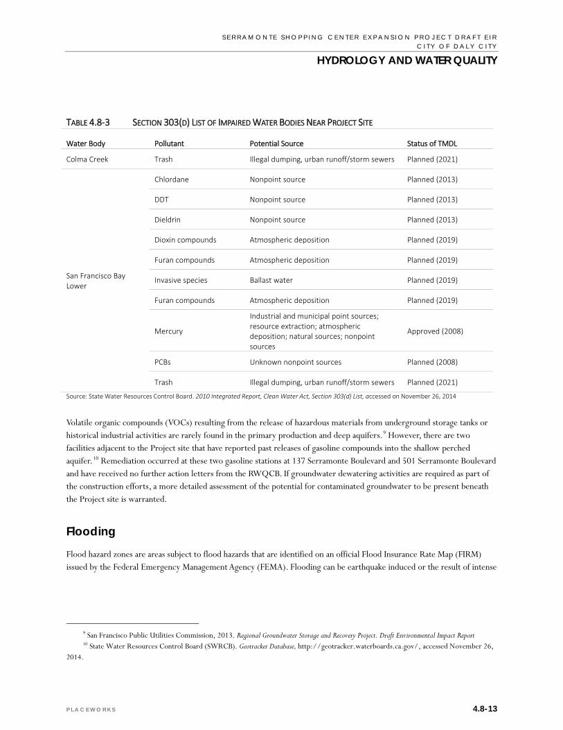
In accordance with Section 303(d) of the CWA, the State must present EPA with a list of impaired water bodies that do not meet water quality standards. Listed impaired water bodies are presented in Table 4.8-3.
Once a water body has been placed on the 303(d) list of impaired waters, states are required to develop a Total Maximum Daily Load (TMDL) to address each pollutant causing impairment. A TMDL defines how much of a pollutant a water body can tolerate and still meet water quality standards. TMDLs have been approved by EPA for mercury in Lower San Francisco Bay.
The Basin Plan also contains water quality criteria for groundwater. The Project site is within the Westside Groundwater Basin. Groundwater in this basin is generally of good quality with no dominant cation; approximately 40 percent of the water sampled is characterized as bicarbonate waters.8 Groundwater generally meets drinking water standards with the exception of elevated nitrate concentrations in portions of Daly City, attributed to past agricultural fertilizer applications and possibly past confined animal facilities such as stockyards. Groundwater from municipal wells located in areas with elevated nitrate concentrations is blended with SFPUC surface water to meet applicable drinking water standards.
8 California Department of Water Resources (DWR). California’s Groundwater Bulletin 118, Basins and Subbasins of the San Francisco Bay
Hydrologic Region, http://www.water.ca.gov/pubs/groundwater/bulletin_118/basindescriptions/2-35.pdf, accessed November 26, 2014.
Source: State Water Resources Control Board. 2010 Integrated Report, Clean Water Act, Section 303(d) List, accessed on November 26, 2014
Volatile organic compounds (VOCs) resulting from the release of hazardous materials from underground storage tanks or historical industrial activities are rarely found in the primary production and deep aquifers.9 However, there are two facilities adjacent to the Project site that have reported past releases of gasoline compounds into the shallow perched aquifer.10 Remediation occurred at these two gasoline stations at 137 Serramonte Boulevard and 501 Serramonte Boulevard and have received no further action letters from the RWQCB. If groundwater dewatering activities are required as part of the construction efforts, a more detailed assessment of the potential for contaminated groundwater to be present beneath the Project site is warranted.
Flooding
Flood hazard zones are areas subject to flood hazards that are identified on an official Flood Insurance Rate Map (FIRM) issued by the Federal Emergency Management Agency (FEMA). Flooding can be earthquake induced or the result of intense
9 San Francisco Public Utilities Commission, 2013. Regional Groundwater Storage and Recovery Project. Draft Environmental Impact Report 10 State Water Resources Control Board (SWRCB). Geotracker Database, http://geotracker.waterboards.ca.gov/, accessed November 26,
S E R R A M O N T E S H O P P I N G C E N T E R E X P A N S I O N P R O J E C T D R A F T E I R C I T Y O F D A L Y C I T Y
HYDROLOGY AND WATER QUALITY
4.8-14 M A R C H 2 0 1 5
rainfall. Areas within a 100-year floodplain have a 1 percent probability of flooding in a given year. According to FIRM Map. Nos. 06081C0036E and 06081C0037E, the Project site is not within a 100-year or 500-year flood zone.11
The California Office of Emergency Services (CalOES) has compiled dam inundation maps for the San Francisco Bay area.12 A review of these maps indicate that the Project site is not located within a dam inundation area. Therefore, the Project would not be subject to flooding due to dam inundation.
A tsunami is a large tidal wave generated by an earthquake, landslide, or volcanic eruption. Tsunami inundation maps have also been developed for the San Francisco Bay area.13 The project site is over 1 mile from the Pacific Ocean and is not within the mapped tsunami inundation area. Therefore, it will not be subject to flooding from a tsunami.
Seiches are waves that oscillate in enclosed water bodies, such as reservoirs, lakes, ponds, swimming pools, or semi-enclosed bodies of water, such as San Francisco Bay. Because the site is far from San Francisco Bay and there are no nearby reservoirs or lakes, it would not be subject to flooding from a tsunami.
The site is also outside of the influence of sea level rise, as shown on the NOAA sea level rise map.14 It is not subject to dike/levee failures. The Project site has a steep slope in the southeast corner of the property and portions of the property are listed as susceptible to debris flows, as per the ABAG landslide maps.15 Therefore, this potential hazard is discussed in more detail in the following section.
STANDARDS OF SIGNIFICANCE 4.8.2An Initial Study was prepared for the Project (see Appendix A of this Draft EIR). Based on the analysis contained in the Initial Study it was determined that development of the Project would not result in significant environmental impacts per the following significance criteria and therefore, are not discussed in this chapter.
Place housing within a 100-year flood hazard area as mapped on a Federal Flood Hazard Boundary or Flood Insurance Rate Map, or other flood hazard delineation map.
Place within a 100-year flood hazard area structures which would impede or redirect flood flows.
Expose people or structures to a significant risk of loss, injury, or death involving flooding, including flooding as a result of the failure of a levee or dam.
11 Federal Emergency Management Agency (FEMA). FIRM Map No. 06081C0036E and 06081C0037E, https://msc.fema.gov/
portal/search?AddressQuery=Daly%20City%2C%20CA, accessed November 26, 2014. 12 California Office of Emergency Services (CalOES), 2009. Dam Inundation Registered Images and Boundary Files in Shape File Format. Version
DVD 3, April. 13 California Emergency Management Agency, 2009. Tsunami Inundation Map for Emergency Planning, San Francisco South Quadrangle (Pacific
Coast), June. 14 National Oceanic and Atmospheric Administration (NOAA), 2014. Sea Level Rise and Coastal Flooding Impacts, http://coast.noaa.gov/
slr/, accessed November 26, 2014. 15 Association of Bay Area Government (ABAG), 2014. Debris Flow Source Areas, http://gis.abag.ca.gov/website/
Hazards/?hlyr=cgsLndsldZones, accessed November 26, 2014.
S E R R A M O N T E S H O P P I N G C E N T E R E X P A N S I O N P R O J E C T D R A F T E I R C I T Y O F D A L Y C I T Y
HYDROLOGY AND WATER QUALITY
P L A C E W O R K S 4.8-15
Be inundated by seiche, tsunami, or mudflow.
Based on the Initial Study it was determined that the Project could result in a significant hydrology or water quality impact if it would:
1. Violate any water quality standards or waste discharge requirements.
2. Substantially deplete groundwater supplies or interfere substantially with groundwater recharge such that there would be a net deficit in aquifer volume or a lowering of the local groundwater table level.
3. Substantially alter the existing drainage pattern of the site or area, including through the alteration of the course of a stream or river, in a manner which would result in substantial erosion, siltation, or flooding on- or off-site.
4. Create or contribute runoff water that would exceed the capacity of existing or planned stormwater drainage systems or provide substantial additional sources of polluted runoff.
5. Provide substantial additional sources of polluted runoff, or otherwise substantially degrade water quality.
IMPACT DISCUSSION 4.8.3
HYDRO-1 The Project would not violate any water quality standards or waste discharge requirements.
Urban runoff can carry a variety of pollutants, such as oil and grease, metals, sediment and pesticide residues from roadways, parking lots, rooftops, landscaped areas and deposit them into adjacent waterways via the storm drain system. Implementation of the Project will redevelop and expand the existing 883,000-square-foot shopping center to accommodate additional retail, restaurant, office space, a hotel, and medical offices, which could create changes to stormwater flows and result in a greater potential to introduce pollutants to receiving waters. Construction activities could result in the degradation of water quality, releasing sediment, oil and greases, and other chemicals to nearby water bodies.
Construction Impacts
Clearing, grading, excavation, and construction activities associated with the Project have the potential to impact water quality through soil erosion and increasing the amount of silt and debris carried in runoff. Additionally, the use of construction materials such as fuels, solvents, and paints may present a risk to surface water quality. Finally, the refueling and parking of construction vehicles and other equipment on-site during construction may result in oil, grease, or related pollutant leaks and spills that may discharge into the storm drain system.
To minimize these potential impacts, the Project will be required to comply with the NPDES General Construction Permit (GCP) as well as prepare a SWPPP that requires the incorporation of BMPs to control sedimentation, erosion, and hazardous materials contamination of runoff during construction. The SWRCB mandates that projects that disturb one or more acres must obtain coverage under the Statewide GCP. Since the Project will replace approximately 500,000 square feet (11.5 acres), it will be subject to these requirements. The GCP also requires that prior to the start of construction
S E R R A M O N T E S H O P P I N G C E N T E R E X P A N S I O N P R O J E C T D R A F T E I R C I T Y O F D A L Y C I T Y
HYDROLOGY AND WATER QUALITY
4.8-16 M A R C H 2 0 1 5
activities; the Project applicant must file PRDs with the SWRCB, which includes a NOI, risk assessment, site map, annual fee, signed certification statement, SWPPP, and post-construction water balance calculations.
In addition, the Project must comply with the City of Daly City’s Grading, Erosion, and Sediment Control Ordinance, as specified in the Chapter 15.62 in the Municipal Code, to minimize potential impacts to water quality. An erosion and sediment control plan must be prepared and submitted with the grading plan for approval by the City Engineer prior to the start of construction. The erosion and sediment control plan shall include the following elements:
Erosion and Sediment Control Plan Prepare document in accordance with the Manual of Standards for Erosion and Sediment Control Measures, published
by ABAG.
Calculate maximum surface runoff from the site, using a method approved by the City Engineer.
Describe and delineate measures to be implemented to retain sediment on the site, including but not limited to, sediment detention basins and traps, and a schedule for their maintenance and upkeep.
Describe and delineate surface runoff and erosion control measures to be implemented, including but not limited to, types and method of applying mulches, designs and specifications for diverters, dikes, and drains, and a schedule for their maintenance and upkeep.
Describe and delineate vegetative measures to be used, including but not limited to, types of seeds and fertilizer and their application rates, the type, location and extent of pre-existing and undisturbed vegetation types, and a schedule for maintenance and upkeep.
Describe any other erosion control measures deemed appropriate by the City Engineer or his/her authorized representative.
Estimate the cost of implementing and maintaining all interim erosion and sediment control measures.
If land disturbance or filling activities are scheduled to occur during the rainy season (between October 15 and April 15), demonstrate to the satisfaction of the City Engineer that erosion and sediment from the construction activities can be controlled. Divert on-site runoff around exposed areas and divert off-site runoff around the site (swales and dikes).
Implementation of the following construction BMPs are also required as per the provisions of the MRP and SMCWPPP C.3 provisions for development projects:
Construction Best Management Practices Control and prevent discharge of all potential pollutants, including pavement cutting wastes, paints, concrete,
petroleum products, chemicals, wash water or sediments, rinse water from architectural copper, and non-stormwater discharges to storm drains and watercourses.
Store, handle, and dispose of construction materials/wastes properly to prevent contact with stormwater.
Do not clean, fuel, or maintain vehicles on-site, except in a designated area where wash water is contained and treated.
S E R R A M O N T E S H O P P I N G C E N T E R E X P A N S I O N P R O J E C T D R A F T E I R C I T Y O F D A L Y C I T Y
HYDROLOGY AND WATER QUALITY
P L A C E W O R K S 4.8-17
Train and provide instruction to all employees and subcontractors regarding the construction BMPs.
Protect all storm drain inlets in the vicinity of the site using sediment controls such as berms, fiber rolls, or filters.
Limit construction access routes and stabilize designated access points.
Attach the SMCWPPP’s construction BMP plan sheet to project plans and require contractors to implement the applicable BMPs on the plan sheet.
Use temporary erosion controls to stabilize all denuded areas until permanent erosion controls are established.
Delineate with field markers clearing limits, easements, setbacks, sensitive or critical areas, buffer zones, trees, and drainage courses.
Perform clearing and earth moving activities only during dry weather.
Use sediment controls or filtration to remove sediment when dewatering and obtain all necessary permits.
Trap sediment on-site, using BMPs such as sediment basins or traps, earthen dikes or berms, silt fences, check dams, soil blankets or mats, covers for soil stockpiles, etc.
Divert on-site runoff around exposed areas; divert off-site runoff around the site (e.g., swales and dikes).
Protect adjacent properties and undisturbed areas from construction impacts using vegetative buffer strips, sediment barriers or filters, dikes, mulching, or other measures as appropriate.
Provide notes, specifications, or attachments describing the following:
Construction, operation, and maintenance of erosion and sediment control measures, including inspection frequency.
Methods and schedule for grading, excavation, filling, clearing of vegetation, and storage and disposal of excavated or cleared material.
Specifications for vegetative cover and mulch, including methods and schedules for planting and fertilization
Provisions for temporary and/or permanent irrigation.
The Project applicant will prepare a SWPPP that addresses these and other structural and non-structural BMPs that will be implemented at the site.
In addition, the City of Daly City reviews individual projects for stormwater conformance with applicable laws, policies, and guidelines and has the authority to inspect and conduct sampling at properties to ensure that the provisions of the City’s Storm Water Management and Discharge Control Ordinance (Title 14 of the Municipal Code) are implemented. With development and implementation of the BMPs in the Erosion and Sediment Control Plan and the SWPPP and compliance with City, County, and State stormwater regulations, the construction impacts to water quality will be less than significant.
S E R R A M O N T E S H O P P I N G C E N T E R E X P A N S I O N P R O J E C T D R A F T E I R C I T Y O F D A L Y C I T Y
HYDROLOGY AND WATER QUALITY
4.8-18 M A R C H 2 0 1 5
Operational Impacts
Runoff from commercial properties and parking lots typically contain oils, grease, fuel, antifreeze, byproducts of combustion (such as lead, cadmium, nickel, and other metals), as well as fertilizers, herbicides, pesticides, and other pollutants. Precipitation at the beginning of the rainy season may result in an initial stormwater runoff (first flush) with high pollutant concentrations.
Water quality in stormwater runoff is regulated locally by the SMCWPPP, which include the C.3 provisions set by the San Francisco Bay RWQCB. The San Mateo Countywide NPDES permit was amended in 2009 and now includes stricter requirements for incorporating post-construction stormwater control/LID measures into new development and redevelopment projects. All development and redevelopment projects must incorporate site design, source control, and treatment measures to the maximum extent practicable and to use stormwater control measures that are technically feasible and not cost prohibitive. Also, each project regulated under the C.3 provisions must treat 100 percent of the amount of runoff for the project’s drainage area with on-site LID treatment measures. Stormwater treatment requirements must be met by using evapotranspiration, infiltration, rainwater harvesting, and reuse, except where this is infeasible in which case landscape-based biotreatment is allowed.
Effective December 1, 2011, the threshold for requiring stormwater treatment was reduced from 10,000 to 5,000 square feet of impervious surface for uncovered parking areas. Since more than 10,000 square feet of impervious surface and more than 5,000 feet of impervious parking area would be replaced by the Project, adherence to the C.3 provisions of the NPDES permit apply and various prescribed measures must be incorporated into the project design. And since the replaced impervious surface equals more than 50 percent of the pre-project impervious surface, the entire site is subject to site design, source control, and stormwater treatment requirements.
The Project will incorporate site design measures, source control measures, and stormwater treatment control measures to minimize potential water quality impacts as follows:
Site Design Measures:
Direct roof runoff to vegetated areas.
Use landscaping to treat stormwater.
Source Control Measures:
On-site and surrounding storm drain inlets shall be clearly marked with the words “No Dumping! Flows to Bay” using methods approved by the City of Daly City.
Trash areas shall be roofed and enclosed to avoid run-on and run-off. Runoff from trash enclosure and recycling areas shall not discharge to the storm drain system.
Outdoor equipment and storage areas shall be covered and bermed, or designed to limit the potential that runoff may contact pollutants. The pavement shall be checked periodically for cracks and fractures, which shall be repaired and sealed.
Loading docks shall be covered and/or graded to minimize run-on and runoff from the loading area. Roof downspouts shall be positioned to direct stormwater away from the loading areas.
S E R R A M O N T E S H O P P I N G C E N T E R E X P A N S I O N P R O J E C T D R A F T E I R C I T Y O F D A L Y C I T Y
HYDROLOGY AND WATER QUALITY
P L A C E W O R K S 4.8-19
Treatment Control Measure – use flow-through infiltration planters or bioretention areas to treat stormwater.
With the implementation of these site designs, source control, and treatment control measures, the potential operational impact to water quality would be less than significant. In summary, there should be no significant impacts to water quality from implementation of this Project.
Applicable Regulations: Code of Federal Regulations Title 40 Parts 122 et seq.: National Pollutant Discharge Elimination System (NPDES)
California Water Code Sections 13000 et seq.: Porter-Cologne Water Quality Act
San Francisco Bay RWQCB Order No. R2-2009-0074: Municipal Regional Permit
SWRCB Construction General Permit (CGP) - 2009-0009-DWQ
San Mateo Countywide Water Pollution Prevention Program and C.3 Technical Guidance
Daly City Stormwater Management and Discharge Control Ordinance (Municipal Code - Title 14)
Daly City Grading, Erosion and Sediment Control Ordinance (Municipal Code - Chapter 15.62)
Significance Before Mitigation: Less than significant.
HYDRO-2 The Project would not substantially deplete groundwater supplies or interfere substantially with groundwater recharge such that there would be a net deficit in aquifer volume or a lowering of the local groundwater table level.
New construction could result in impacts related to groundwater if the construction would require dewatering or reduce groundwater recharge. Groundwater recharge may be reduced if areas currently available for the infiltration of rainfall runoff are reduced and permeable areas are replaced by impermeable surfaces. Project implementation would involve the creation of approximately 500,000 square feet of impermeable surface consisting of buildings and hardscaped areas, which would replace the same amount of impermeable surface consisting mostly of parking lots. There would be no net increase in the amount of impervious surface at the Project site and therefore no reduction in groundwater recharge. Buildout of the Project would lead to an increased demand for water. The Project site is located within the South Westside Groundwater Basin and the City obtains approximately 40 percent of its water supply from local groundwater wells. Although the South Westside Basin is not a formally adjudicated basin, the cities of San Bruno, Daly City, and the California Water Service Company have established pumping limitations with implementation of the Groundwater Storage and Recovery Agreement, which was formally executed on December 16, 2014. Daly City has agreed to self-limit groundwater pumping to 3.43 million gallons per day. Water supply impacts are discussed in detail in Chapter 4.14, Utilities and Service Systems, of this Draft EIR. The WSA reported a projected water demand of approximately 35,000 gallons/day (gpd) with implementation of the Project and concluded that there were sufficient water supplies available to serve the Project for the normal year, single dry year, and multiple dry year scenarios through 2035.16 The analysis is based on 2013 ABAG demographic projections and include passive (plumbing and building code requirements) and active conservation savings. In
16 Brown and Caldwell, 2014. Draft Water Supply Assessment for Serramonte Center Expansion. Prepared for the City of Daly City, September.
S E R R A M O N T E S H O P P I N G C E N T E R E X P A N S I O N P R O J E C T D R A F T E I R C I T Y O F D A L Y C I T Y
HYDROLOGY AND WATER QUALITY
4.8-20 M A R C H 2 0 1 5
addition, Daly City does not plan to increase its total long-term groundwater pumping above existing levels and the Westside Groundwater Basin is not in critical condition from overdraft.17 Therefore, the Project would have a less-than-significant impact on groundwater supply.
Grading, cut-and-fill activities, and building construction at the Project site may encounter shallow groundwater. Groundwater elevations at two gasoline stations on the northeast and southwest corners of the intersection of Gellert Boulevard and Serramonte Boulevard were reported to range from 5 to 15 feet bgs. Therefore, temporary construction dewatering may be necessary. However, the Project is not anticipated to adversely impact groundwater resources because required excavations would intersect only the shallow groundwater table with no impact to the regional groundwater system. Dewatering would be a temporary occurrence and there are no municipal groundwater wells in the vicinity of the Project site. A Waste Discharge Requirement (WDR) permit would be required from the San Francisco Bay RWQCB for construction dewatering activities and the WDR permit would require testing to ensure that discharged water did not pose a risk to water quality. In summary, the impact of the Project on groundwater supplies or groundwater recharge would be less than significant.
Applicable Regulations: California Water Code Sections 13000 et seq.: Porter-Cologne Water Quality Act
Daly City Well Standards (Municipal Code - Chapter 13.20)
Significance Before Mitigation: Less than significant.
HYDRO-3 The Project would not substantially alter the existing drainage pattern of the site or area, including through the alteration of the course of a stream or river, in a manner which would result in substantial erosion, siltation, or flooding on- or off-site.
The Project is within the boundaries of an existing shopping center that has previously been developed and is currently connected to the City’s storm drain system. The proposed expansion does not involve alteration of any natural drainage channels or any watercourse. It also would not alter existing drainage patterns other than creating a new storm drain infrastructure within the property and incorporate the use of LID and BMP measures for treatment and flow control prior to discharge into the storm drain system. The Project would involve site improvements that would require grading or soil exposure during construction. If not controlled, the transport of these materials into local waterways could temporarily increase suspended sediment concentrations. To minimize this impact, the Project would be required to comply with all of the requirements in the State GCP, including preparation of PRDs and submittal of a SWPPP to the SWRCB prior to the start of construction activities. The implementation of BMPs during the construction phase would include the following measures to minimize erosion and siltation:
Minimize disturbed areas of the site.
Install onsite sediment basins to prevent off-site migration of erodible materials.
17 City of Daly City, 2011. 2010 Urban Water Management Plan.
S E R R A M O N T E S H O P P I N G C E N T E R E X P A N S I O N P R O J E C T D R A F T E I R C I T Y O F D A L Y C I T Y
HYDROLOGY AND WATER QUALITY
P L A C E W O R K S 4.8-21
Implement dust control measures, such as silt fences and regular watering of open areas.
Stabilize construction entrances/exits.
Install storm drain inlet protection measures.
Install sediment control measures around the site, including silt fences or gravel bag barriers.
Compliance with the established permits and regulations will ensure that impacts from erosion and siltation both on- and off-site would be less than significant.
The Project site is already developed and is not expected to generate stormwater runoff in excess of present volumes. The Project will replace approximately 500,000 square feet of existing impervious surface (parking lots) with the same amount of impervious surface (buildings and hardscaped areas). Thus, there should be no net increase in the amount of stormwater runoff from the site. In addition, the Project is required to comply with San Mateo County’s C.3 provisions of the NPDES permit. The City of Daly City also requires all project applicants to submit a SWMP that shows full compliance with the MRP and C.3 provisions. These provisions require BMPs to be implemented across the Project site which incorporate site design, source control, and treatment control measures that provide both flow control and treatment to runoff before it enters the storm drain system. Although the size and location of the treatment control measures have not yet been determined, the Project applicant indicates that the majority of the stormwater runoff would be channeled into flow-through infiltration planters. Bioretention areas can also be incorporated into the site design. Treated stormwater runoff would be gradually released to the storm drain system, thus ensuring that there is no net increase in runoff from the site.
A change in the timing and volume of runoff from a site is called “hydromodification.” Projects that are in susceptible areas, as defined in the SMCWPPP, are required to incorporate one or more hydromodification management (HM) measures in the design. The Project site is not located in a susceptible area, as shown on the San Mateo Countywide HM Control Area Map, and therefore HM measures are not required.18
According to the Daly City General Plan, no significant flooding issues have been identified in the vicinity of the Project site. With the implementation of site BMPs and LID treatment measures, the Project would not substantially increase the rate or amount of surface runoff in a manner that would cause flooding. Therefore, impacts related to drainage and flooding would be less than significant.
Applicable Regulations: Code of Federal Regulations Title 40 Parts 122 et seq.: National Pollutant Discharge Elimination System (NPDES) California Water Code Sections 13000 et seq.: Porter-Cologne Water Quality Act San Francisco Bay RWQCB Order No. R2-2009-0074: Municipal Regional Permit SWRCB Construction General Permit (CGP) - 2009-0009-DWQ San Mateo Countywide Water Pollution Prevention Program and C.3 Technical Guidance Daly City Stormwater Management and Discharge Control Ordinance (Municipal Code - Title 14)
Daly City Grading, Erosion and Sediment Control Ordinance (Municipal Code - Chapter 15.62)
18 San Mateo Countywide Water Pollution Prevention Program (SMCWPP), 2014. C.3 Stormwater Technical Guidance. Version 4.1,
October.
S E R R A M O N T E S H O P P I N G C E N T E R E X P A N S I O N P R O J E C T D R A F T E I R C I T Y O F D A L Y C I T Y
HYDROLOGY AND WATER QUALITY
4.8-22 M A R C H 2 0 1 5
Significance Before Mitigation: Less than significant.
HYDRO-4 The Project would not create or contribute runoff water that would exceed the capacity of existing or planned stormwater drainage systems or provide substantial additional sources of polluted runoff.
Urban development has two potential impacts to stormwater runoff hydrology. Impervious surfaces, such as roads, sidewalks, and buildings prevent the natural infiltration of stormwater into the soil and thus create higher runoff volumes. In addition, more rapid transport of runoff over impermeable surfaces combined with higher runoff volumes cause elevated peak flows. This increase in flows may adversely impact stormwater drainage systems.
The Project involves expansion of an existing shopping center that is currently connected to the City’s storm drain system via catch basins throughout the property. The Project includes the replacement of approximately 500,000 square feet of impervious surface (parking lots) with the same amount of impervious surface associated with buildings and hardscaped plazas. Therefore, there will be no net increase in stormwater runoff and the Project must comply with the SMCWPPP C.3 provisions.
Although the Project is expected to rely on existing stormwater infrastructure wherever possible, if necessary, extensions, additions, and/or re-routing of stormwater infrastructure would be installed to adequately serve the runoff at the Project site. Although these modifications, if necessary, are determined to be required by the City, short-term construction-related environmental effects could occur, most of the work would be in existing right-of-ways or facilities, and would be subject to compliance with applicable regulations and standard conditions for stormwater construction projects, including City permits/review for construction. For example, the City would require engineering and/or stormwater studies with information, such as anticipated flows, calculated pipe size, and slope gradients to determine to ensure stormwater infrastructure is accurate to accommodate runoff from the Project site.
Furthermore, the City of Daly City requires the Project applicant to submit a SWMP that provides the BMPs and LID treatment features that will be implemented at the site. One of the proposed treatment measures is the use of flow-through planters to treat and detain runoff prior to discharge to the City’s storm drain system. As a result, there will be no significant increase in site runoff as compared to existing (pre-development) conditions. Stormwater discharge from the site is currently collected in catch basins, which connect to storm drains that vary in size from 15 inches to 66-inches and eventually discharge into the 7-foot Colma Creek arch culvert. The existing storm drain system will be able to handle the stormwater flow from the site, which would be reduced from existing conditions with the implementation of BMPs and LID measures, and the impact to stormwater drainage systems would be less than significant.
Applicable Regulations: San Francisco Bay RWQCB Order No. R2-2009-0074: Municipal Regional Permit San Mateo Countywide Water Pollution Prevention Program and C.3 Technical Guidance Daly City Stormwater Management and Discharge Control Ordinance (Municipal Code - Title 14)
Significance Before Mitigation: Less than significant.
S E R R A M O N T E S H O P P I N G C E N T E R E X P A N S I O N P R O J E C T D R A F T E I R C I T Y O F D A L Y C I T Y
HYDROLOGY AND WATER QUALITY
P L A C E W O R K S 4.8-23
HYDRO-5 The Project would not provide substantial additional sources of polluted runoff, or otherwise substantially degrade water quality.
Pollutants commonly associated with construction sites that can impact stormwater are sediments, nutrients, trace metals, pesticides, oil, grease, fuels, and miscellaneous construction wastes. Pollutants generated from the operational phase of the Project may include sediment, nutrients, organic compounds, trash and debris, oxygen-demanding substances, bacteria and viruses, oil and grease, and pesticides/herbicides.
As required by City and County storm water management guidelines, BMPs will be implemented across the Project site during both construction and operation of the Project. These BMPs will control and prevent the release of sediment, debris, and other pollutants into the storm drain system. Implementation of BMPs during construction will be in accordance with the provisions of the SWPPP, which will minimize the release of sediment, soil, and other pollutants. Operational BMPs will be required to meet the C.3 provisions of the SMCWPPP and the applicant will be required to submit a SWMP to the City for approval prior to the start of construction. These requirements include the incorporation of site design, source control, and treatment control measures to treat and control runoff before it enters the storm drain system. One of the proposed treatment measures is the use of flow-through planters to treat and detain runoff prior to discharge to the City’s storm drain system. With implementation of these BMPs in accordance with City and County requirements, the potential impact on water quality would be less than significant.
Applicable Regulations: Code of Federal Regulations Title 40 Parts 122 et seq.: National Pollutant Discharge Elimination System (NPDES)
San Francisco Bay RWQCB Order No. R2-2009-0074: Municipal Regional Permit
SWRCB Construction General Permit (CGP) - 2009-0009-DWQ
San Mateo Countywide Water Pollution Prevention Program and C.3 Technical Guidance
Daly City Stormwater Management and Discharge Control Ordinance (Municipal Code - Title 14)
Daly City Grading, Erosion and Sediment Control Ordinance (Municipal Code - Chapter 15.62)
Significance Before Mitigation: Less than significant.
CUMULATIVE IMPACTS 4.8.4
HYDRO-6 The Project, in combination with past, present, and reasonably foreseeable projects, would not result in significant cumulative impacts with respect to hydrology and water quality.
The context for the analysis of cumulative hydrology and water quality impacts is the City of Daly City, including cumulative growth associated with City-approved projects and other foreseeable future projects (see Chapter 4.0). Development of the Project in conjunction with construction activities, increases in impervious surfaces, and alterations to drainage patterns associated with other development within Daly City could increase stormwater runoff and contribute to decreased water quality in receiving waters.
S E R R A M O N T E S H O P P I N G C E N T E R E X P A N S I O N P R O J E C T D R A F T E I R C I T Y O F D A L Y C I T Y
HYDROLOGY AND WATER QUALITY
4.8-24 M A R C H 2 0 1 5
The Project site is located in an area that is almost completely developed and will not generate stormwater runoff in excess of present volumes. All development or redevelopment projects in Daly City would also be required to comply with San Mateo County’s C.3 provisions that require BMPs to be implemented. These BMPs include site design, source control, and treatment control measures that provide both flow control and treatment to runoff before it enters the storm drain system. Similarly, all projects would be required to comply with the GCP, prepare a SWPPP, and implement BMPs to minimize erosion and siltation impacts during construction. As a result, impacts to stormwater flow volumes and water quality will be less than significant.
Development throughout the City could alter existing drainage patterns, resulting in increases in runoff volume to the existing storm drain system. As stated in the EIR for the Daly City General Plan Update, the majority of future projects under the General Plan would be redevelopment with little or no increase in impervious surface.19 Given the built out environment in the City and the requirement for all projects to implement site BMPs, the volume, velocity, and peak runoff quantities of runoff to the storm drain system should not be substantially greater than pre-project conditions. Therefore, cumulative impacts to hydrology and water quality would be less than significant
Applicable Regulations:
Code of Federal Regulations Title 40 Parts 122 et seq.: National Pollutant Discharge Elimination System (NPDES)
San Francisco Bay RWQCB Order No. R2-2009-0074: Municipal Regional Permit
SWRCB Construction General Permit (CGP) - 2009-0009-DWQ
San Mateo Countywide Water Pollution Prevention Program and C.3 Technical Guidance
Daly City Stormwater Management and Discharge Control Ordinance (Municipal Code - Title 14)
Daly City Grading, Erosion and Sediment Control Ordinance (Municipal Code - Chapter 15.62)
Significance Before Mitigation: Less than significant.
19 City of Daly City, 2012. City of Daly City General Plan Update, Draft Environmental Impact Report, October.