Reynolds Creek, ID 15 15 Semi-arid 500 mountainous
Yanco, Australia 13 13
Semi-arid to
temperate450 flat
1. Provide a local assessment of soil moisture derived rainfall product over 10 selected sites using 3 different algorithms
2. Provide a 0.25° assessment of SMOS derived rainfall product over 9 selected sites
3. Provide a global assessment of SMOS derived rainfall product (50°N-50°S)
SMOS+Rainfall project
How we can improve satellite rainfall estimates with soil moisture observations? (1)
Crow et al. 2009-2011
Pellarin et al. (2008)
we can correct satellite rainfall
estimates by assimilating soil
moisture observations into
land surface models…
How we can improve satellite rainfall estimates with soil moisture observations? (2)
Or…we can estimate rainfall directly
from soil moisture and
integrate these estimates with satellite rainfall observations
How to assign the weights?
= +int 2 2( ) SM RAIN SM RAIN SAT SATP t P W P W
Satellite rainfall product (e.g., 3B42RT)
SM2RAIN derived rainfall
weightsIntegrated rainfall
PSM2RAIN
How to integrate SM2RAIN rainfall with satellite rainfall?
Given a REFERENCE (i.e., a high-quality ground-based rainfalldataset Pobs ) we can maximize the correlation between Pint and the reference Pobs
N.B. with some simplifications
How to integrate SM2RAIN rainfall with satellite rainfall?
Given a REFERENCE (i.e., a high-quality ground-based rainfalldataset Pobs ) we can maximize the correlation between Pint and the reference Pobs
N.B. with some simplifications
But we do not have such a good reference everywhere …
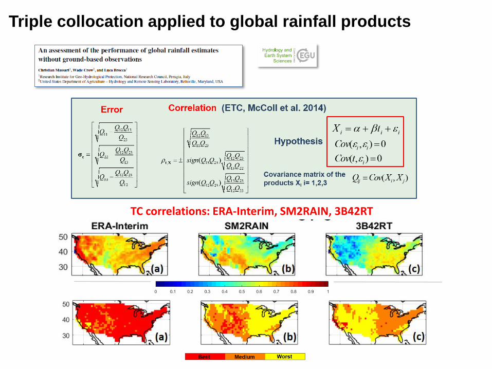
Triple collocation applied to global rainfall products
TC correlations: ERA-Interim, SM2RAIN, 3B42RT
Triple collocation applied to global rainfall products
TC correlations: ERA-Interim, SM2RAIN, 3B42RT
How to use Triple Collocation for integrating SM2RAIN with other satellite rainfall estimates?
( )
( )
xyx
xy y
xz
xx yz
xzz
yxz yy
xz
xy z
yz
z xy yzz
yz
Q QR
Q Q
Q QR sign Q Q
Q Q
Q QR sign Q Q
Q Q
=
=
=
Triple Collocation Weights calculation
Now correlations are given by TC and we do not need the ground reference anymore
Objective: Using SMOS (via SM2RAIN) for improving
satellite-only rainfall products with TC-based weights
Which products?Product Reference Type Spatial resolution
SMOS level-3 RE04 Al Bitar et al. 2017
Soil moisture 0.25°
3B42RT v7.0 Huffman et al. 2007
Satellite-only rainfall
0.25°
CMORPH raw 1.0 Joyce et al. 2004 Satellite-only rainfall
0.25°
ERA-Interim Dee et al. 2011 Reanalysis rainfall ≃0.7°
GPCC Schneider et al. 2014
Ground rainfall 1°
Other gauge based networks
Ground rainfall 0.25°
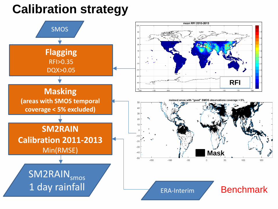
SMOS
SM2RAINCalibration 2011-2013
Min(RMSE)
FlaggingRFI>0.35
DQX>0.05
SM2RAINsmos1 day rainfall Benchmark
Calibration strategy
Masking(areas with SMOS temporal
coverage < 5% excluded)
Mask
RFI
ERA-Interim
Extended Triple Collocation(McColl et al. 2014)
2014-2015
N.B. Triplets 2 and 4 were adopted only for checkingthe consistency of the results
Triple Collocation and weight calculations
SM2RAINsmosSRP (3B42RT,
CMORPH) ERA-Interim GPCC
SM2R
AINsm
osC
MO
RPH
2014-2015 PSMOS+CMORPH 0.25°
Validation strategy (2014-2015)
Local scale, on 10 selected sites(pixel scale, daily and 5-daily)
Validation strategy (2014-2015)
Eobs 14-15CPC 14-15
IMD 14-15
AWAP 14-15
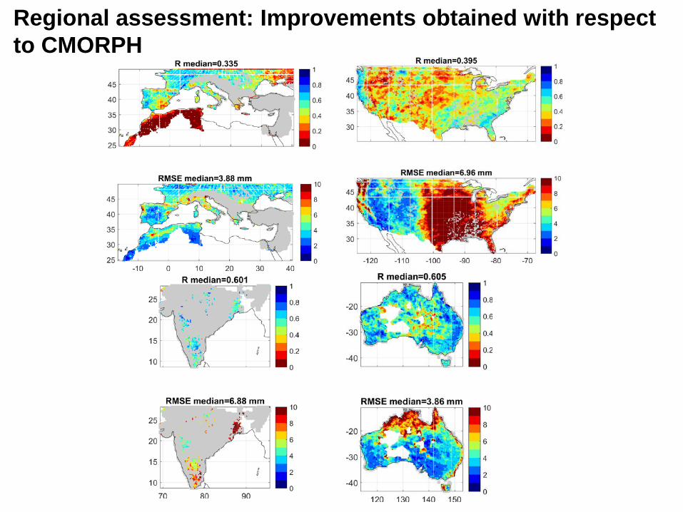
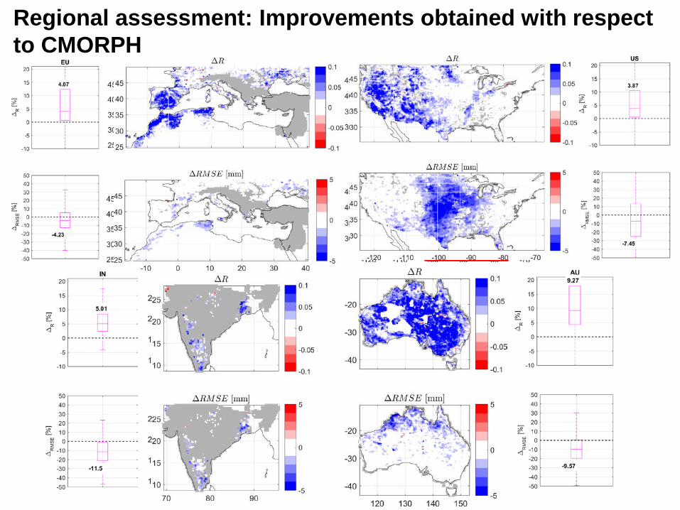
Regional scale in India, US, Europe and Australia(daily, 0.25°)
mas
kva
lidat
ion
Validation strategy (2014-2015)
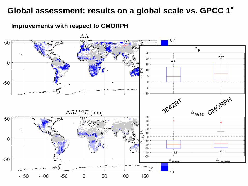
Global scale using GPCC 1° as a reference(N.B. areas characterized by low rain gauges density of GPCC weremasked out)
FINAL MASKED AREAS= LOW SMOS TEMPORAL COVERAGE due to flagging + LOW DENSITY OF GPCC RAIN GAUGES
Local scale: Results on the 10 sites of the SMOS+Rainfall project
5.8 7.110.1
-17.4 -16.8-19.8
-25.0
-20.0
-15.0
-10.0
-5.0
0.0
5.0
10.0
15.0
% c
hang
es
% changes in daily correlation and RMSEobtained with SM2RAINsmos integration
Correlation RMSE
3B42
RT+
SM2R
smos
CM
OR
PH+S
M2R
smos
PER
SIAN
N+S
M2R
smos
10 SMOS sitesImprovements with respect to 3B42RT, CMORPH, PERSIANN
Regional assessment: Improvements obtained with respect to CMORPH
Regional assessment: Improvements obtained with respect to CMORPH
Regional assessment: Improvements obtained with respect to CMORPH
Global assessment: results on a global scale vs. GPCC 1°
Improvements with respect to CMORPH
Global assessment: results on a global scale vs. GPCC 1°
Improvements with respect to CMORPH
Global assessment: results on a global scale vs. GPCC 1°
Improvements with respect to CMORPH
Global assessment: results on a global scale vs. GPCC 1°
Improvements with respect to CMORPH
Conclusions• Triple collocation can be successfully used for merging different
rainfall datasets• Results confirm that SMOS can provide improvements of satellite-
only rainfall estimates where its quality is high and its temporal coverage is sufficiently dense
• The integrated product can be implemented in real time with several advantages in some applications
• The analysis has taken into account only continuous scores (i.e., correlation and RMSE). The effect of the integration on the categorical scores and on the BIAS has to be still thoroughly quantified
• Other soil moisture sensors (ASCAT, SMAP) can be potentially used
Local scale Regional scale Global scale R 5-10% 3-10% 5-7%