TIERRA ROBLES PLANNED DEVELOPMENT ZONE AMENDMENT 10-002 TRACT MAP 1996 SCH NO. 2012102051 DRAFT ▪ OCTOBER 2017 5.10-1 LAND USE AND PLANNING 5.10 LAND USE AND PLANNING This section of the Environmental Impact Report (EIR) describes the affected environment and regulatory setting for land use and planning on the proposed project site. It also describes the impacts on land use and planning that would result from implementation of the proposed project, including consistency with relevant plans and programs that have jurisdiction within the project area and compatibility with surrounding land uses, and provides mitigation measures that would reduce these impacts, as appropriate. The following analysis of the potential environmental impacts related to land use and planning is derived primarily from the following sources and agencies: • Shasta County. Shasta County General Plan. 2004. • Shasta County. Shasta County Code Title 17, Zoning. 2016. • Shasta County. Shasta County Zoning Plan. 2016. • Shasta County. Shasta County Code, Title 15, Subdivision Regulations. 2016. • Shasta County. Shasta County Grading Ordinance, Section 12.12. • Shasta County. Parks, Trails and Open Space Plan. August 2009. • Shasta County Local Agency Formation Commission. The following section discusses the existing land uses in the proposed project area, in addition to land use conditions, such as type of use and/or densities adjacent to the project that would influence land use compatibility. The environmental setting of the proposed project site consists of the physical conditions or existing land uses on the project site and in the surrounding areas. 5.10.1 ENVIRONMENTAL SETTING The proposed project site is located in unincorporated Shasta County, which is in California’s Northern Sacramento Valley. Land uses within Shasta County are predominantly related to forestry and agricultural production, although over the last few decades, urban development has increased in a number of areas, such as in and around the City of Redding and smaller communities throughout Shasta County. ONSITE LAND USES The proposed project encompasses approximately 715.4 acres and is currently undeveloped vacant land. A single wood and wire corral, some interior fences, and a network of dirt ranch roads crisscross the proposed project site. Onsite topography is characterized as level to rolling terrain in the western portion of the proposed project site, and steeper slopes and ridges are located in the eastern portion of the property, with elevations ranging from approximately 600 feet above mean sea level (msl) to 650 feet above msl. The proposed project site is dissected by three major drainage systems: Clough Creek, which flows southwest across the northwest corner of the property; an unnamed stream that flows south across the east central portion of the property; and a major unnamed drainage that flows from north to southeast across the eastern side of the property. In addition, there are two small streams with attached tributaries which drain the central portion of the property. The proposed project site has been used for ranching and grazing cattle activities since 1894.
Transcript
TIERRA ROBLES PLANNED DEVELOPMENT ZONE AMENDMENT 10-002
TRACT MAP 1996 SCH NO. 2012102051
DRAFT ▪ OCTOBER 2017 5.10-1 LAND USE AND PLANNING
5.10 LAND USE AND PLANNING This section of the Environmental Impact Report (EIR) describes the affected environment and regulatory setting for land use and planning on the proposed project site. It also describes the impacts on land use and planning that would result from implementation of the proposed project, including consistency with relevant plans and programs that have jurisdiction within the project area and compatibility with surrounding land uses, and provides mitigation measures that would reduce these impacts, as appropriate. The following analysis of the potential environmental impacts related to land use and planning is derived primarily from the following sources and agencies:
• Shasta County. Shasta County General Plan. 2004.
• Shasta County. Shasta County Code Title 17, Zoning. 2016.
• Shasta County. Shasta County Zoning Plan. 2016.
• Shasta County. Shasta County Code, Title 15, Subdivision Regulations. 2016.
• Shasta County. Shasta County Grading Ordinance, Section 12.12.
• Shasta County. Parks, Trails and Open Space Plan. August 2009.
• Shasta County Local Agency Formation Commission.
The following section discusses the existing land uses in the proposed project area, in addition to land use conditions, such as type of use and/or densities adjacent to the project that would influence land use compatibility. The environmental setting of the proposed project site consists of the physical conditions or existing land uses on the project site and in the surrounding areas.
5.10.1 ENVIRONMENTAL SETTING The proposed project site is located in unincorporated Shasta County, which is in California’s Northern Sacramento Valley. Land uses within Shasta County are predominantly related to forestry and agricultural production, although over the last few decades, urban development has increased in a number of areas, such as in and around the City of Redding and smaller communities throughout Shasta County.
ONSITE LAND USES The proposed project encompasses approximately 715.4 acres and is currently undeveloped vacant land. A single wood and wire corral, some interior fences, and a network of dirt ranch roads crisscross the proposed project site. Onsite topography is characterized as level to rolling terrain in the western portion of the proposed project site, and steeper slopes and ridges are located in the eastern portion of the property, with elevations ranging from approximately 600 feet above mean sea level (msl) to 650 feet above msl. The proposed project site is dissected by three major drainage systems: Clough Creek, which flows southwest across the northwest corner of the property; an unnamed stream that flows south across the east central portion of the property; and a major unnamed drainage that flows from north to southeast across the eastern side of the property. In addition, there are two small streams with attached tributaries which drain the central portion of the property. The proposed project site has been used for ranching and grazing cattle activities since 1894.
TIERRA ROBLES PLANNED DEVELOPMENT ZONE AMENDMENT 10-002
TRACT MAP 1996 SCH NO. 2012102051
DRAFT ▪ OCTOBER 2017 5.10-2 LAND USE AND PLANNING
EXISTING GENERAL PLAN DESIGNATION
The Shasta County General Plan planning area is divided into 10 Planning Areas. The proposed project is located within the South Central Region Planning Area. Chapter 3 of the Shasta County General Plan identifies three distinct types of communities: Urban Center, Town Center, and Rural Community Center. The proposed project site is not within any of these community types; however, it is located near Bella Vista (Rural Center) and Palo Cedro (Town Center). The Shasta County General Plan designates the proposed project site as Rural Residential A (RA) (1 dwelling unit / 2 acres). The following provides a brief description of the land use designation:
• Rural Residential A (RA): The (RA) land use designation shall be primarily applied to rural community centers and urban and town center fringes in order to accommodate residential development. The (RA) land use designation provides living environments receiving no, or only some urban services, usually within or near a Rural Community Center. A maximum density for this land use designation is 1 dwelling per 2 acres.
EXISTING ZONE DISTRICTS
California Government Code §6586021 requires zoning to be consistent with the general plan. Consistency with the general plan is possible only if the local government, in this case Shasta County, has officially adopted a general plan. The land uses authorized in the Shasta County Zoning Plan must be compatible with the objectives, policies, general land uses, and programs specified in the Shasta County General Plan.
The Shasta County Zoning Plan identifies APNs 061-240-001 and 061-210-001 as Rural Residential (R-R), with a minimum lot area of three to five acres (R-R-BA-3 and R-R-BA-5). Existing zoning on APNs 078-250-002, 078-060-036 and 078-060-039 is Unclassified (U). The following provides a brief description of existing onsite zoning districts:
• Rural Residential 5-acre minimum (RR-BA-5). The purpose of the rural residential (R-R) zoning district is to provide rural residential living environments, usually located in and around rural communities, town centers, and urban centers. This district is consistent with the Rural Residential A (RA) General Plan land use designation. The building site (B) district is intended to be combined with any principal district to modify the minimum lot area standard otherwise applicable in the principal district. (BA) is the minimum lot area expressed in acres, as indicated by a number following the hyphen. Uses permitted in the B district are all uses permitted in the principal district with which the B district is combined, and those uses permitted in the principal district by zoning, administrative and use permit provided the permit is issued.
• Rural Residential 3-acre minimum (RR-BA-3). The (RR-BA-3) zoning district permits the same uses as stated above for the RR-BA-5 designation; however, this designation has a three-acre minimum lot area instead of a five-acre minimum lot area.
• Unclassified (U). The (U) zoning district is intended to be applied as a holding district until a precise zone district has been determined and adopted for the property.1 All new uses in this district shall be consistent with all applicable policies of the General Plan.
1 In order to determine the appropriate zoning and density for a specific site, the Shasta County General Plan recommends a review of detailed site-specific information and completion of a land capability analysis before precise zoning is identified. This EIR reflects the County’s site-specific land capability analysis necessary to determine the suitability of the proposed Tierra Robles Planned Development Project.
TIERRA ROBLES PLANNED DEVELOPMENT ZONE AMENDMENT 10-002
TRACT MAP 1996 SCH NO. 2012102051
DRAFT ▪ OCTOBER 2017 5.10-3 LAND USE AND PLANNING
In the R-R-BA-3 and R-R-BA-5 zones, the maximum density for land greater than 30 percent slope is one dwelling unit per 10 acres and the maximum density for land less than 30 percent slope is one dwelling unit per three to five acres. In all cases, each building site area shall contain at least one contiguous acre not exceeding a 30 percent slope. Required building setbacks include 30 feet on the front, side, and rear. Maximum allowable structural height for the homes is 35 feet in the R-R zoning district.
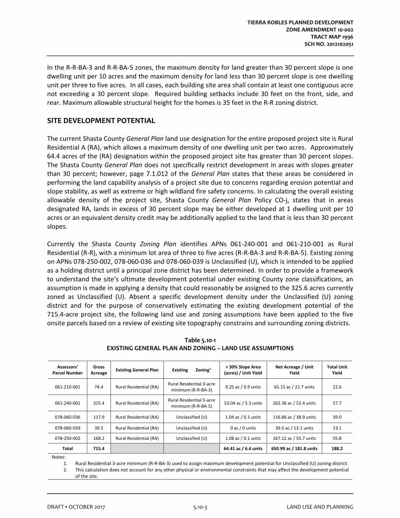
SITE DEVELOPMENT POTENTIAL The current Shasta County General Plan land use designation for the entire proposed project site is Rural Residential A (RA), which allows a maximum density of one dwelling unit per two acres. Approximately 64.4 acres of the (RA) designation within the proposed project site has greater than 30 percent slopes. The Shasta County General Plan does not specifically restrict development in areas with slopes greater than 30 percent; however, page 7.1.012 of the General Plan states that these areas be considered in performing the land capability analysis of a project site due to concerns regarding erosion potential and slope stability, as well as extreme or high wildland fire safety concerns. In calculating the overall existing allowable density of the project site, Shasta County General Plan Policy CO-j, states that in areas designated RA, lands in excess of 30 percent slope may be either developed at 1 dwelling unit per 10 acres or an equivalent density credit may be additionally applied to the land that is less than 30 percent slopes. Currently the Shasta County Zoning Plan identifies APNs 061-240-001 and 061-210-001 as Rural Residential (R-R), with a minimum lot area of three to five acres (R-R-BA-3 and R-R-BA-5). Existing zoning on APNs 078-250-002, 078-060-036 and 078-060-039 is Unclassified (U), which is intended to be applied as a holding district until a principal zone district has been determined. In order to provide a framework to understand the site’s ultimate development potential under existing County zone classifications, an assumption is made in applying a density that could reasonably be assigned to the 325.6 acres currently zoned as Unclassified (U). Absent a specific development density under the Unclassified (U) zoning district and for the purpose of conservatively estimating the existing development potential of the 715.4-acre project site, the following land use and zoning assumptions have been applied to the five onsite parcels based on a review of existing site topography constrains and surrounding zoning districts.
Table 5.10-1 EXISTING GENERAL PLAN AND ZONING – LAND USE ASSUMPTIONS
Assessors’ Parcel Number
Gross Acreage
Existing General Plan Existing Zoning1 > 30% Slope Area
minimum (R-R-BA-5) 53.04 ac / 5.3 units 262.36 ac / 52.4 units 57.7
078-060-036 117.9 Rural Residential (RA) Unclassified (U) 1.04 ac / 0.1 units 116.86 ac / 38.9 units 39.0
078-060-039 39.5 Rural Residential (RA) Unclassified (U) 0 ac / 0 units 39.5 ac / 13.1 units 13.1
078-250-002 168.2 Rural Residential (RA) Unclassified (U) 1.08 ac / 0.1 units 167.12 ac / 55.7 units 55.8
Total 715.4 64.41 ac / 6.4 units 650.99 ac / 181.8 units 188.2
Notes: 1. Rural Residential 3-acre minimum (R-R-BA-3) used to assign maximum development potential for Unclassified (U) zoning district. 2. This calculation does not account for any other physical or environmental constraints that may affect the development potential
of the site.
TIERRA ROBLES PLANNED DEVELOPMENT ZONE AMENDMENT 10-002
TRACT MAP 1996 SCH NO. 2012102051
DRAFT ▪ OCTOBER 2017 5.10-4 LAND USE AND PLANNING
Based on Table 5.10-1, above, it can be assumed that the maximum development potential for the 325.6 Unclassified (U) acres could allow up to 188 dwelling units. As noted in Table 5.10-1, the County’s existing land use and zoning for the proposed project site could yield a maximum of 188 single-family residential dwelling units or 1 dwelling unit per 3.7 gross acres. It should also be noted that although every approved residential lot would be entitled to a secondary dwelling unit (e.g., accessory dwelling unit) pursuant to Government Code Section 65852.2, similar to the proposed project it is assumed that approximately 9 percent of residential lots would have secondary units resulting in approximately 17 secondary units being developed under the existing General Plan and zoning designations for the site.
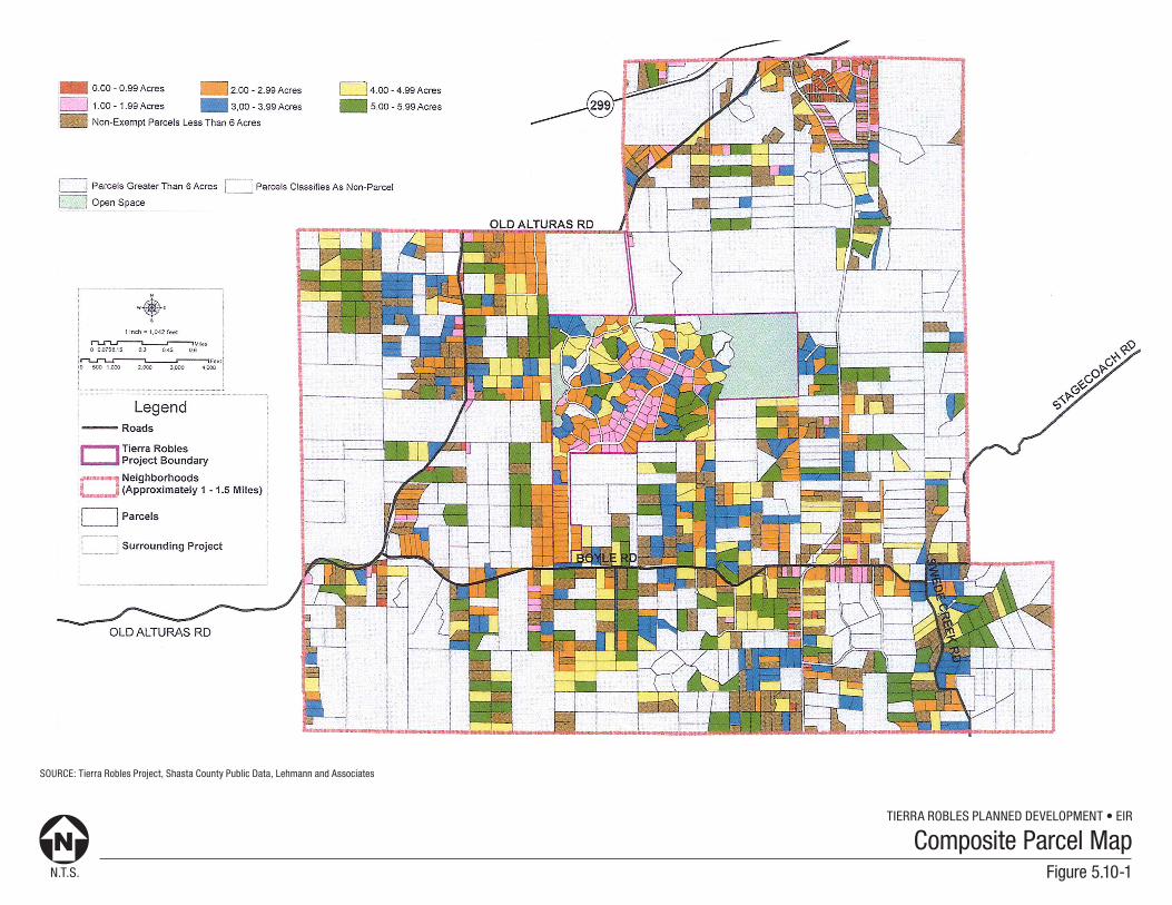
SURROUNDING LAND USES Immediately surrounding land uses consist primarily of rural residential, agricultural, and grazing uses with parcels generally ranging between 2 to 20 acres. Within a mile to a mile and a half of the proposed project site there are approximately 1,005 parcels that are less than 6 acres. North
Areas to the north of the project site consist of single-family residential units and undeveloped land used for cattle grazing activities. This land is designated as Rural Residential A (RA) by the County. Existing zoning districts consist of the following: Exclusive Agriculture (EA) and Unclassified (U). Two water impoundments totaling approximately nine acres are present to the north between the northeastern portion of the project site and Seven Lakes Road, as well as a gun and rod club on adjacent parcels northeast of the project site. Old Alturas Road / Seven Lakes Road is located approximately ½-mile north of the proposed project. Clough Creek extends north of the site, generally in a northeast direction. East
Deschutes Road is located east of the proposed project. Land to the east consists of single-family residential units and undeveloped land that range in parcel size from 5 to 10 acres. The Shasta County General Plan designates properties east of the project as Rural Residential A (RA). Existing zoning districts consist of Rural Residential 5-acre minimum (R-R-BA-5); Rural Residential 3-acre minimum (R-R-BA-3); Rural Residential 2.5-acre minimum (R-R-BA-2.5); Rural Residential with Mobile Home 3-acre minimum (R-R-T-BA-3); Rural Residential with Mobile Home 2.5-acre minimum (R-R-T-BA-2.5); Rural Residential with Mobile Home (R-R-T) and Unclassified (U). Deschutes Road is located approximately ¼ mile to the east (from the project’s easternmost boundary). South
Land to the south of the proposed project site consists of single-family residential units and undeveloped land. Adjacent properties to the south consist primarily of 5 to 10-acre parcels used for residential and part-time agricultural activities. This land is designated as Rural Residential A (RA) by the County. Existing zoning districts to the south consist of the following: Rural Residential with Mobile Home (R-R-T); Rural Residential with Mobile Home 3-acre minimum (R-R-T-BA-3); Rural Residential 3-acre minimum (R-R-BA-3); Rural Residential with Mobile Home 2.5-acre minimum (R-R-T-BA-2.5), and Unclassified (U). Boyle Road is an east-west roadway located immediately adjacent to the project’s southernmost boundary.
TIERRA ROBLES PLANNED DEVELOPMENT ZONE AMENDMENT 10-002
TRACT MAP 1996 SCH NO. 2012102051
DRAFT ▪ OCTOBER 2017 5.10-5 LAND USE AND PLANNING
West
Land to the west of the proposed project site consists of single-family residential units and undeveloped land. Adjacent properties to the west consist primarily of 5 to 10-acre parcels used for residential and part-time agricultural activities. The Shasta County General Plan designates properties west of the site as Rural Residential A (RA). Existing zoning districts to the west consist of the following: Rural Residential with Mobile Home 3-acre minimum (R-R-T-BA-3); Rural Residential with Mobile Home (R-R-T), and Unclassified (U).
5.10.2 REGULATORY SETTING Land use and planning decisions within and adjacent to the project site are regulated by a variety of jurisdictional planning agencies, programs, and documents including the Shasta County General Plan and the Shasta County Zoning Plan. The Shasta County General Plan contains goals, objectives, and policies and provides an overall foundation for establishing land use patterns. This Draft EIR section lists all relevant goals, objectives, policies, and implementation measures related to the proposed land use. Relevant goals, policies, and implementation measures related to other resource areas are included in their respective sections of this Draft EIR. The Shasta County Zoning Plan contains regulations through which the General Plan’s provisions are implemented. The most relevant regulations pertaining to the proposed land use are presented below.
STATE Government Code Section 65852.2 – Accessory Dwelling Unit The California legislature found and declared that, among other things, allowing accessory dwelling units (ADUs) in single-family and multi-family zones provides additional rental housing and are an essential component in addressing housing needs in California. Over the years, ADU law has been revised to improve its effectiveness such as recent changes in 2003 to require ministerial approval. In January 2017, changes to ADU laws further reduce barriers, better streamline approval and expand capacity to accommodate the development of ADUs. As a result, any local ordinance adopted prior to January 1, 2017 that is not in compliance with the changes to ADU law are considered to be null and void. In the absence of a local ordinance complying with ADU law, local review must be limited to “state standards” and cannot include additional requirements such as those in an existing ordinance. A local government cannot preclude ADUs.
California Environmental Quality Act
The California Environmental Quality Act (CEQA) establishes that a significant effect on the environment involves an adverse change to the physical environment. Pursuant to the State CEQA Guidelines, a project’s impact related to land use planning is evaluated in terms of compatibility with existing land uses and consistency with local plans and other local land use controls (i.e., general plans, zoning codes, specific plans, etc.).
TIERRA ROBLES PLANNED DEVELOPMENT ZONE AMENDMENT 10-002
TRACT MAP 1996 SCH NO. 2012102051
DRAFT ▪ OCTOBER 2017 5.10-6 LAND USE AND PLANNING
LOCAL Shasta County General Plan
Under California law, cities and counties must adopt a comprehensive, long-term general plan, which consists of a set of goals and policies that guide local land use decisions. The general plan must, at a minimum, contain seven elements – land use, circulation, housing, conservation, open space, noise, and safety. The general plan must also contain a map or diagram within the land use element illustrating land use distribution by type of use, such as commercial, residential, and open space. A jurisdiction may choose to organize their general plan with the mandatory elements in the order that meets the communities’ needs. Mandatory elements may also be combined, as is often the case with open space and conservation or noise and safety. A jurisdiction may adopt additional elements to address unique needs of the community. The Shasta County General Plan, last amended in 2004, serves as the principal land use planning and policy document for the County. It identifies strategies, policies, and implementation recommendations for land use within its planning area. The Shasta County General Plan is a long-range comprehensive plan that governs growth and development in the unincorporated areas of Shasta County, including the proposed project site. The Shasta County General Plan consists of three primary groups: public safety, resources, and community development. Contained within these three broad groups are 22 individual sections that address the issues of the seven required general plan elements. Shasta County Zoning Plan
The Shasta County Zoning Plan (Title 17 of the Shasta County Code) is one of the chief tools for implementing the recommendations found in the Shasta County General Plan. It creates a series of zone districts throughout the County and specifies a number of uses suited to those districts. Additionally, development standards are established for each district to ensure that activities can be reasonably accommodated in a manner that is compatible with adjacent land uses. The purposes of the Shasta County Zoning Plan provisions are:
• To promote and protect the public health, safety, peace, morals, comfort, convenience and general welfare;
• To implement the Shasta County General Plan, and to facilitate and guide growth in accordance with the Shasta County General Plan; and
• To protect the social and economic stability of residential, commercial, industrial, resource production, and recreational activities within the county through the orderly, planned use of the land.
Shasta County Code, Title 15, Subdivision Regulations
The Subdivision Regulations outline the requirements and standards necessary for preparing and submitting tentative subdivision maps for review and approval. The Subdivision Regulations are intended to encourage orderly community development by providing for the regulation and control of the design and improvement of the subdivision, with proper consideration of its relation to adjoining areas; to ensure that the areas within the subdivision that are dedicated for public purposes will be properly improved by the subdivider so that they will not become an undue burden on the community; to implement the objectives established for development of the county in conformance with the goals
TIERRA ROBLES PLANNED DEVELOPMENT ZONE AMENDMENT 10-002
TRACT MAP 1996 SCH NO. 2012102051
DRAFT ▪ OCTOBER 2017 5.10-7 LAND USE AND PLANNING
and policies of the general plan and adopted development policies; to limit undue fiscal impacts to the County; and to protect the public and transferee of parcels created through the subdivision process. Shasta County Grading Ordinance, Chapter 12.12
The Shasta County Grading Ordinance (Grading Ordinance) sets forth regulations concerning grading, excavating, and filling. The Grading Ordinance prohibits any grading of more than 250 cubic yards or 10,000 square feet of disturbance area without a grading permit from the County. The grading permit must include an approved grading plan provided by the project applicant, and it must set forth terms and conditions of grading operations that conform to the County’s grading standards. The permit also requires the project applicant to provide a permanent erosion control plan that must be implemented upon completion of the project. In practice, specific erosion-control measures are determined upon review of the final subdivision grading plan and are tailored to project-specific grading impacts. Shasta County Parks, Trails and Open Space Plan
The intent of the Shasta County Parks, Trails and Open Space Plan (August 2009) is to identify the issues and opportunities for improving the provision of parks, trails, and open space in Shasta County. The plan outlines a set of strategies and recommendations for meeting current and future community needs based on changing trends in recreation, new patterns for recreation participation, and new areas of growth and development in the County. Shasta County Community Plan Areas
The Shasta County Planning Department has a number of plans made specifically for designated community or plan areas (i.e. the Cottonwood Community Plan and the Columbia Area Plan). These plans describe policies and objectives specifically related to that area. The proposed project in not located within a community plan. Shasta County Air Quality Management District The proposed project is within the Shasta County Air Quality Management District (SCAQMD), which is part of the Sacramento Valley Air Basin. The Sacramento Valley Air Basin has been further divided into two planning areas called the Northern Sacramento Valley Air Basin (NSVAB) and the Greater Sacramento Air region. Shasta County is located in the NSVAB. The Air Pollution Control Districts and Air Quality Management Districts for the counties located in the northern portion of the Sacramento Valley together comprise the Northern Sacramento Valley Planning Area (NSVPA). The Northern Sacramento Valley Planning Area 2012 Triennial Air Quality Attainment Plan (AQAP) identifies those portions of the NSVPA designated as “non-attainment” for the State ambient air quality standards. The AQAP identifies the air pollution problems which are to be cooperatively addressed on as many fronts as possible in order to make the region a healthier place to live now and in the future. The 2012 AQAP focuses on the adoption and implementation of control measures for stationary sources, area wide sources, and indirect sources, and addresses public education and information programs. The 2012 AQAP also addresses the effect that pollutant transport has on the ability of the NSVPA to meet and attain State standards.
TIERRA ROBLES PLANNED DEVELOPMENT ZONE AMENDMENT 10-002
TRACT MAP 1996 SCH NO. 2012102051
DRAFT ▪ OCTOBER 2017 5.10-8 LAND USE AND PLANNING
Shasta County Regional Transportation Plan The Shasta Regional Transportation Agency (SRTA) is the agency responsible for transportation planning for the Shasta County region, including the three cities and the unincorporated area. The planning process is in compliance with the laws and guidelines developed by Caltrans and the Federal Department of Transportation. This responsibility includes development and adoption of transportation policy direction, review and coordination of transportation planning, preparation and endorsement of an Overall Work Program (OWP), a Regional Transportation Plan (RTP), a Regional Transportation Improvement Plan (RTIP), and a Federal Transportation Improvement Plan (FTIP). Refer to Section 5.16, TRAFFIC AND CIRCULATION. Shasta County Local Agency Formation Commission (LAFCO)
The Shasta County Local Agency Formation Commission (LAFCO) is an independent agency responsible for the implementation of the Cortese-Knox-Hertzberg Local Government Reorganization Act of 2000 (Act). The Act, Government Code §56000 et seq., identifies the responsibilities of LAFCO, which include the review, approval, and/or denial of boundary changes, annexations, consolidations, special district formations, incorporations for cities and special districts, and the establishment of local “Spheres of Influence” (SOI) which are boundaries established for each governmental agency for future provision of services. The Shasta County LAFCO promotes policies discouraging urban sprawl, preserving open-space and prime agricultural land, efficiently extending services, and promoting orderly development through providing housing for persons and families of all incomes.
Section 56001 of the Act states that direction should be “effected by the logical formation and modification of the boundaries of local agencies, with a preference granted to accommodating additional growth within or through the expansion of, the boundaries of those local agencies which can best accommodate and provide necessary governmental services and housing.” While Section 56001 promotes that a single multipurpose governmental agency “may be the best mechanism for establishing community service priorities especially in urban areas”, limited purpose agencies also play a critical role in providing services, especially in rural areas and areas in transition from rural to urban.
5.10.3 STANDARDS OF SIGNIFICANCE
SIGNIFICANCE CRITERIA In accordance with State CEQA Guidelines, the effects of a project are evaluated to determine whether they would result in a significant adverse impact on the environment. An EIR is required to focus on these effects and offer mitigation measures to reduce or avoid any significant impacts that are identified. The criteria used to determine the significance of impacts may vary depending on the nature of the project. According to Appendix G of the State CEQA Guidelines, the proposed project would have a significant impact related to land use and planning, if it would:
• Physically divide an established community. Refer to AREAS OF NO PROJECT IMPACT, below.
• Conflict with any applicable land use plan, policy, or regulation of an agency with jurisdiction over the project (including, but not limited to the general plan, specific plan, local coastal program, or zoning ordinance) adopted for the purpose of avoiding or mitigating an environmental effect. Refer to Impact 5.10-1, below.
TIERRA ROBLES PLANNED DEVELOPMENT ZONE AMENDMENT 10-002
TRACT MAP 1996 SCH NO. 2012102051
DRAFT ▪ OCTOBER 2017 5.10-9 LAND USE AND PLANNING
• Conflict with any applicable habitat conservation plan or natural community conservation plan. Refer to AREAS OF NO PROJECT IMPACT, below.
Regarding plan or policy consistency, the proposed project is evaluated in terms of whether its site plan, design features, and/or development at this location would substantially impede or thwart implementation of an adopted plan or policy. Evaluation of the potential impacts of the proposed project on land use and planning was based on a review of the Shasta County General Plan (2004) and the Shasta County Zoning Plan (2016). General plan consistency does not mean strict conformity of a project with each and every general plan objective and policy. Rather, a project is consistent if it is in agreement or harmony with the general plan considered as a whole. In other words, a project may not have to strictly or substantially conform to a particular general plan policy or policies. CEQA requires that an EIR consider whether a proposed project may conflict with any applicable land use plan, policy, or regulation (including, but not limited to the general plan, specific plan, or zoning ordinance) that was adopted for the purpose of avoiding or mitigating an environmental effect (refer to Appendix G to the State CEQA Guidelines). This environmental determination differs from the larger policy determination of whether a proposed project is consistent with a jurisdiction’s general plan. The broader General Plan consistency determination takes into account all evidence in the record concerning the project characteristics, its desirability, as well as its economic, social, and other non-environmental effects. As such, the Shasta County Board of Supervisors, the final decision-maker for the proposed project, may determine that the proposed project is (or is not) consistent with the County’s General Plan despite any conclusion reached by the EIR that the proposed project may (or may not) conflict with policies adopted for the purpose of avoiding or mitigating an environmental impact. Notwithstanding the significance criteria stated above, it should be noted that the mere fact that a project might be inconsistent in some manner with particular policies in a general plan or zoning ordinance does not, per se, amount to a significant environmental effect. In the context of land use and planning, significant impacts occur when a conflict with any applicable land use plan, policy or regulation of an agency with jurisdiction over the project results in an adverse physical environmental impact.
Based on these standards, the effects of the proposed project have been categorized as either a “less than significant” impact or a “potentially significant” impact. Mitigation measures are recommended for potentially significant impacts. If a potentially significant impact cannot be reduced to a less than significant level through the application of mitigation, it is categorized as a “significant and unavoidable” impact.
AREAS OF NO PROJECT IMPACT
In October 2012 and February 2016, the County conducted an Initial Study to determine significant effects of the proposed project. In the course of this evaluation, certain impacts of the proposed project were found to not to be significant because of the inability of a project of this scope to create such impacts or the absence of project characteristics producing effects of this type. The effects determined not to be significant are not required to be included in primary analysis sections of the Draft EIR. As such, the following impacts either are not applicable to the proposed project or are not reasonably foreseeable and are not addressed further within this section (refer to Section 10.0, EFFECTS FOUND NOT TO BE SIGNIFICANT):
TIERRA ROBLES PLANNED DEVELOPMENT ZONE AMENDMENT 10-002
TRACT MAP 1996 SCH NO. 2012102051
DRAFT ▪ OCTOBER 2017 5.10-10 LAND USE AND PLANNING
• Physically divide an established community.
• Conflict with any applicable habitat conservation plan or natural community conservation plan.
5.10.4 POTENTIAL IMPACTS AND MITIGATION MEASURES
METHODOLOGY For the purposes of this analysis, relevant planning documents, particularly the Shasta County General Plan and the Shasta County Code, Title 15, Subdivision Regulations, were consulted. The proposed project was qualitatively assessed to determine whether it would conflict with any applicable land use plan, policy, or regulations, including habitat conservation plans. If the proposed project was determined to conflict with a relevant plan, a determination was then made as to whether the conflict or inconsistency would result in a significant physical environmental impact that would otherwise be mitigated or avoided without implementation of the proposed project. Land use and planning impacts are analyzed below according to topic. Mitigation measures directly correspond with an identified impact. Pursuant to Government Code Section 65852.2, each residential lot would be eligible to construct a secondary unit. However, it is anticipated that only 15 of the proposed 166 residential lots (i.e., 9 percent) would include an accessory dwelling unit. This projection is based on data compiled as part of the Shasta County’s 2009-2014 Housing Element (Appendix B-Residential Land Inventory) and the County’s Draft Housing Element (Appendix B-Residential Land Inventory) was utilized. Secondary units are assumed to be up to 1,200 square feet in floor area, with 2 bedrooms and 2 occupants per unit.
IMPACT 5.10-1
The proposed project would not conflict with an applicable land use plan, policy, or regulation of an agency with jurisdiction over the project (including, but not limited to the general plan, specific plan, local coastal program, or zoning ordinance) adopted for the purpose of avoiding or mitigating an environmental effect.
Significance: Less Than Significant Impact. Impact Analysis: Land use compatibility is a function of how well a project is integrated with surrounding land uses. Land use compatibility impacts can be measured in terms of specific environmental effects such as noise, air quality, visual resources, and traffic. The land use compatibility analysis is therefore supported by other specific discussions within this Draft EIR. All development proposed in the County is reviewed for consistency with land use controls and development standards during the course of the project review and approval process. Development of the proposed project would require consultation and acquisition of required permits and approvals by responsible and trustee agencies that have jurisdiction over the project site. The project’s consistency with the Shasta County General Plan and Shasta County Zoning Plan, as well as applicable policies of the Shasta County LAFCO, are discussed below. Consistency with other plans are addressed in the respective resource sections of this Draft EIR, where appropriate.
TIERRA ROBLES PLANNED DEVELOPMENT ZONE AMENDMENT 10-002
TRACT MAP 1996 SCH NO. 2012102051
DRAFT ▪ OCTOBER 2017 5.10-11 LAND USE AND PLANNING
Shasta County General Plan Consistency Project approval would allow the proposed project site to be subdivide the approximate 715.4-acre property into 166 residential parcels ranging from 1.38 acres to 6.81 acres in size (15 parcels would include an ADU), and six open space parcels ranging from 2.6 acres to 154.9 acres in size, totaling 192.7 acres of open space. The proposed project is consistent with the existing Rural Residential A (RA) General Plan land use designation for the site, and no changes to the existing land use designation is required to allow future development. The proposed project is consistent with the existing pattern of land use as stated in Section 7.1.2 of the Shasta County General Plan, as the proposed project is within 5 to 8 miles of the Interstate 5 corridor and is characterized as rural and would be served by “community water and/or sewer districts.” While the implementation of the proposed project would result in the development of property currently vacant and undeveloped, it would set aside 192.7 acres as permanent open space within the project area. However, the natural setting of the area would be changed as a result of the implementation of the proposed project. This change from an undeveloped character to a developed rural character for this site is planned for and consistent with future growth as intended in the County’s General Plan. CEQA requires a project be evaluated for consistency with applicable plans that have been implemented to protect the environment. Shasta County’s General Plan is one such plan that includes policies for the protection of various environmental resources of the County. Conflicts with applicable policies that result in adverse physical impacts may be considered significant impacts under CEQA. Applicable goals and policies relative to the proposed project site are listed in Table 5.10-2, CONSISTENCY ANALYSIS WITH SHASTA COUNTY GENERAL PLAN OBJECTIVES AND POLICIES FOR LAND USE AND PLANNING, followed by a brief explanation of how the proposed project complies with the goals and policies. Table 5.10-2 is not intended to be a final determination of project or map consistency with the Shasta County General Plan. This consistency finding will be addressed in the project staff report. Shasta County Zoning Plan Consistency Surrounding zoning districts consist of the following: Exclusive Agriculture (EA) and Unclassified (U) to the north; Rural Residential 5-acre minimum (R-R-BA-5), Rural Residential 3-acre minimum (R-R-BA-3), Rural Residential 2.5-acre minimum (R-R-BA-2.5), Rural Residential with Mobile Home 3-acre minimum (R-R-T-BA-3), Rural Residential with Mobile Home 2.5-acre minimum (R-R-T-BA-2.5), Rural Residential with Mobile Home (R-R-T), and Unclassified (U) to the east; Rural Residential with Mobile Home (R-R-T), Rural Residential with Mobile Home 3-acre minimum (R-R-T-BA-3), Rural Residential 3-acre minimum (R-R-BA-3), Rural Residential with Mobile Home 2.5-acre minimum (R-R-T-BA-2.5), and Unclassified (U) to the south; and Rural Residential with Mobile Home 3-acre minimum (R-R-T-BA-3); Rural Residential with Mobile Home (R-R-T); and Unclassified (U) to the west. The Shasta County Zoning Plan identifies APNs 061-240-001 and 061-210-001 as Rural Residential (R-R), with a minimum lot area of 3 to 5 acres (R-R-BA-3 and R-R-BA-5). Existing zoning on APNs 078-250-002, 078-060-036 and 078-060-039 is Unclassified (U). As stated above, the County’s existing Zone Plan for the site includes Rural Residential (R-R), with a minimum lot area of three to five acres (74.4 acres zoned R-R-BA-3 and 315.4 acres zoned R-R-BA-5), and 325.6 acres zoned Unclassified (U). The allowable densities under Unclassified (U) zoning district are undefined until a land capability analysis has been
TIERRA ROBLES PLANNED DEVELOPMENT ZONE AMENDMENT 10-002
TRACT MAP 1996 SCH NO. 2012102051
DRAFT ▪ OCTOBER 2017 5.10-12 LAND USE AND PLANNING
performed and a precise zone district has been adopted for the property, although new uses in this district shall be consistent with all applicable policies of the Shasta County General Plan. The proposed project would require Zone Amendment to apply the Planned Development (PD) zone district to the existing Rural Residential (R-R), with a minimum lot area of three to five acres (R-R-BA-3 and R-R-BA-5) and Unclassified (U) zoning districts. According to Chapter 17.62, Planned Development (PD) District, of the Shasta County Zone Plan:
“The purpose of the planned development (PD) district is to provide for developments that, because of a mix of building types, land uses or residential lot sizes, do not fit within the parameter of standard zone districts. Planned developments are under unified control, comprehensively planned, and can provide a mix of uses that could otherwise create land use conflicts. Planned developments often provide common areas and other amenities not normally found in standard types of development. This district is consistent with all General Plan designations that provide for substantial residential, commercial, or industrial development, provided the proposed uses are consistent with the General Plan designation(s) within which the project is located.”
Development within the Planned Development (PD) district shall be consistent with any adopted area plans, density provisions of the Shasta County General Plan land use designation, and must be compatible with surrounding land uses. In addition, the project proposes Design Guidelines to direct future architecture and site layout of individual lots. The proposed Design Guidelines are intended to provide property owners, architects, homebuilders and contractors with a set of parameters for the preparation of construction drawings and specifications. The proposed Design Guidelines provide strict criteria for the siting of onsite structures (i.e., sensitively placed in consideration of existing topography and site features) and strong emphasis of utilizing vegetation screens for homes through a coordinated landscape program (refer to Appendix 15.2, TIERRA ROBLES COMMUNITY SERVICES DISTRICT). Compatibility with Offsite Land Uses The proposed subdivision layout considers the natural physical characteristics and constraints of the property by avoiding sensitive habitat areas, minimizing cut and fill by following the natural contour of the land, and by preserving significant clusters of Oak trees. As a result, the proposed project does not conform to the grid like pattern of residential lots within the surrounding area. The proposed design is intended to maintain a semi-rural appearance given the siting of proposed building envelopes, the extent of open space preservation (approximately 74.2%), and the overall density of the development (1 dwelling unit per 4.4 gross acres). The proposed parcels range in size from 1.38 acres to 6.81 acres with the smallest lots (1.3 acres to 2 acres) sited internal to the subdivision. The proposed project would be required to comply with Shasta County Code, Title 17, Zoning, which is designed to ensure land use compatibility and orderly development. Regulations for setbacks, density, allowed land use, and other elements of development projects serve to reduce incompatibility that might otherwise accompany unplanned development. As previously stated above, within a mile to a mile and a half of the proposed project, there are approximately 1,005 parcels less than 6 acres (refer to Figure 5.10-1, COMPOSITE PARCEL MAP). Although the proposed project would alter current conditions on the site, the proposed project would be compatible in density with the surrounding existing uses. The proposed rezone would not change the rural character of the area or the site as originally intended in the Shasta County General Plan.
N.T.S.
TIERRA ROBLES PLANNED DEVELOPMENT • EIR
Figure 5.10-1
Composite Parcel Map
SOURCE: Tierra Robles Project, Shasta County Public Data, Lehmann and Associates
TIERRA ROBLES PLANNED DEVELOPMENT ZONE AMENDMENT 10-002
TRACT MAP 1996 SCH NO. 2012102051
DRAFT ▪ OCTOBER 2017 5.10-14 LAND USE AND PLANNING
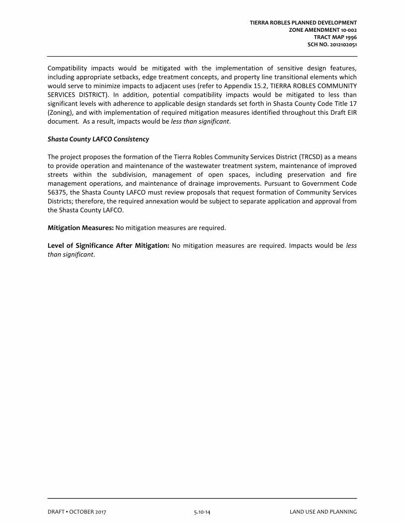
Compatibility impacts would be mitigated with the implementation of sensitive design features, including appropriate setbacks, edge treatment concepts, and property line transitional elements which would serve to minimize impacts to adjacent uses (refer to Appendix 15.2, TIERRA ROBLES COMMUNITY SERVICES DISTRICT). In addition, potential compatibility impacts would be mitigated to less than significant levels with adherence to applicable design standards set forth in Shasta County Code Title 17 (Zoning), and with implementation of required mitigation measures identified throughout this Draft EIR document. As a result, impacts would be less than significant. Shasta County LAFCO Consistency The project proposes the formation of the Tierra Robles Community Services District (TRCSD) as a means to provide operation and maintenance of the wastewater treatment system, maintenance of improved streets within the subdivision, management of open spaces, including preservation and fire management operations, and maintenance of drainage improvements. Pursuant to Government Code 56375, the Shasta County LAFCO must review proposals that request formation of Community Services Districts; therefore, the required annexation would be subject to separate application and approval from the Shasta County LAFCO. Mitigation Measures: No mitigation measures are required. Level of Significance After Mitigation: No mitigation measures are required. Impacts would be less than significant.
TIERRA ROBLES PLANNED DEVELOPMENT ZONE AMENDMENT 10-002
TRACT MAP 1996 SCH NO. 2012102051
DRAFT ▪ OCTOBER 2017 5.10-15 LAND USE AND PLANNING
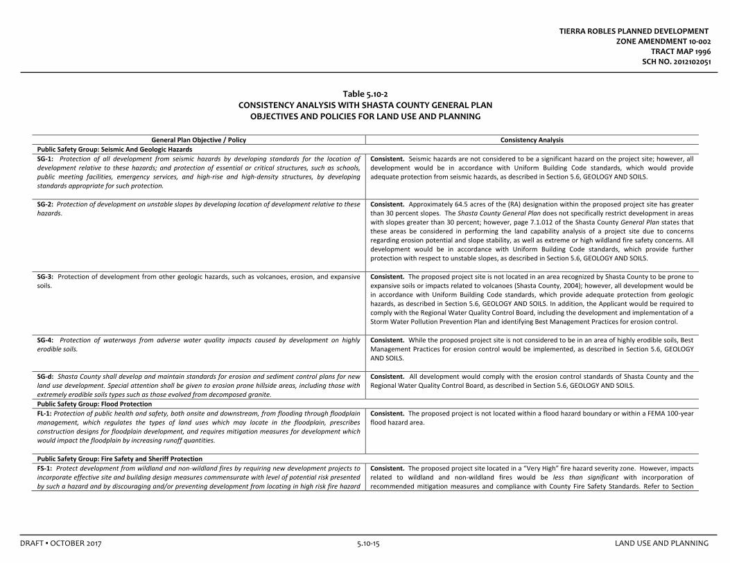
Table 5.10-2 CONSISTENCY ANALYSIS WITH SHASTA COUNTY GENERAL PLAN
OBJECTIVES AND POLICIES FOR LAND USE AND PLANNING
General Plan Objective / Policy Consistency Analysis
Public Safety Group: Seismic And Geologic Hazards
SG-1: Protection of all development from seismic hazards by developing standards for the location of development relative to these hazards; and protection of essential or critical structures, such as schools, public meeting facilities, emergency services, and high-rise and high-density structures, by developing standards appropriate for such protection.
Consistent. Seismic hazards are not considered to be a significant hazard on the project site; however, all development would be in accordance with Uniform Building Code standards, which would provide adequate protection from seismic hazards, as described in Section 5.6, GEOLOGY AND SOILS.
SG‐2: Protection of development on unstable slopes by developing location of development relative to these hazards.
Consistent. Approximately 64.5 acres of the (RA) designation within the proposed project site has greater than 30 percent slopes. The Shasta County General Plan does not specifically restrict development in areas with slopes greater than 30 percent; however, page 7.1.012 of the Shasta County General Plan states that these areas be considered in performing the land capability analysis of a project site due to concerns regarding erosion potential and slope stability, as well as extreme or high wildland fire safety concerns. All development would be in accordance with Uniform Building Code standards, which provide further protection with respect to unstable slopes, as described in Section 5.6, GEOLOGY AND SOILS.
SG-3: Protection of development from other geologic hazards, such as volcanoes, erosion, and expansive soils.
Consistent. The proposed project site is not located in an area recognized by Shasta County to be prone to expansive soils or impacts related to volcanoes (Shasta County, 2004); however, all development would be in accordance with Uniform Building Code standards, which provide adequate protection from geologic hazards, as described in Section 5.6, GEOLOGY AND SOILS. In addition, the Applicant would be required to comply with the Regional Water Quality Control Board, including the development and implementation of a Storm Water Pollution Prevention Plan and identifying Best Management Practices for erosion control.
SG-4: Protection of waterways from adverse water quality impacts caused by development on highly erodible soils.
Consistent. While the proposed project site is not considered to be in an area of highly erodible soils, Best Management Practices for erosion control would be implemented, as described in Section 5.6, GEOLOGY AND SOILS.
SG-d: Shasta County shall develop and maintain standards for erosion and sediment control plans for new land use development. Special attention shall be given to erosion prone hillside areas, including those with extremely erodible soils types such as those evolved from decomposed granite.
Consistent. All development would comply with the erosion control standards of Shasta County and the Regional Water Quality Control Board, as described in Section 5.6, GEOLOGY AND SOILS.
Public Safety Group: Flood Protection
FL-1: Protection of public health and safety, both onsite and downstream, from flooding through floodplain management, which regulates the types of land uses which may locate in the floodplain, prescribes construction designs for floodplain development, and requires mitigation measures for development which would impact the floodplain by increasing runoff quantities.
Consistent. The proposed project is not located within a flood hazard boundary or within a FEMA 100-year flood hazard area.
Public Safety Group: Fire Safety and Sheriff Protection
FS-1: Protect development from wildland and non-wildland fires by requiring new development projects to incorporate effective site and building design measures commensurate with level of potential risk presented by such a hazard and by discouraging and/or preventing development from locating in high risk fire hazard
Consistent. The proposed project site located in a “Very High” fire hazard severity zone. However, impacts related to wildland and non-wildland fires would be less than significant with incorporation of recommended mitigation measures and compliance with County Fire Safety Standards. Refer to Section
TIERRA ROBLES PLANNED DEVELOPMENT ZONE AMENDMENT 10-002
TRACT MAP 1996 SCH NO. 2012102051
DRAFT ▪ OCTOBER 2017 5.10-16 LAND USE AND PLANNING
General Plan Objective / Policy Consistency Analysis
areas. 5.8, HAZARDS AND HAZARDOUS MATERIALS.
FS-a: All new land use projects shall conform to the County Fire Safety Standards. Consistent. The proposed development would be reviewed for consistency with the County Fire Safety Standards, by the County Fire Marshal. Refer to Section 5.8, HAZARDS AND HAZARDOUS MATERIALS.
FS-b: Known fire hazard information should be reported as part of every General Plan amendment, zone change, use permit, variance, building site approval, and all other land development applications subject to the requirements of the California Environmental Quality Act (CEQA).
Consistent. Fire hazard information is presented in Section 5.8, HAZARDS AND HAZARDOUS MATERIALS.
FS-e: Development in areas requiring expanded levels of police and fire services shall participate in adopted County programs designed to offset the added costs for providing the expanded level of services.
Consistent. The one-time fire/law enforcement protection per unit development fees and property taxes generated from the proposed project would result in increased revenue to the General Fund that would assist in offsetting increased costs associated with SCFD/CAL FIRE and County Sheriff services. Refer to Section 5.13, PUBLIC SERVICES AND FISCAL IMPACTS.
Public Safety Group: Noise
N-a: New noise-sensitive uses shall not be allowed in areas where the noise level created by existing non-transportation noise sources will exceed the noise level standards of Table N–IV (from the Shasta County General Plan) as measured immediately within the property line or within a designated outdoor activity area (at the discretion of the Planning Director) of the proposed project, unless effective noise mitigation measures will be incorporated into the project design to achieve compliance with the standards specified in Table N-IV.
Consistent. Project-related noise analyses and determinations are described in Section 5.11, NOISE. The proposed project would not result in long-term mobile noise impacts based on project generated traffic as well as cumulative and incremental noise levels.
Public Safety Group: Hazardous Materials
HM-1: Protection of life and property from contact with hazardous materials through site design and land use regulations and storage and transportation standards.
Consistent. The proposed project would not result in undue exposure of life or property to hazardous materials. Project-related hazardous materials analyses and determinations are described in Section 5.8, HAZARDS AND HAZARDOUS MATERIALS.
HM-2: Protection of life and property in the event of the accidental release of hazardous materials through emergency preparedness planning.
Consistent. The proposed project would not result in undue exposure of life or property to the accidental release of hazardous materials. Project-related hazardous materials analyses and determinations are described in Section 5.8, HAZARDS AND HAZARDOUS MATERIALS, and mitigation measures prescribed in Section 5.16, TRAFFIC AND CIRCULATION will ensure adequate emergency access to the proposed project site.
Resources Group: Agricultural Lands
AG-3: Recognition by Shasta County residents that the preservation of agricultural lands for agricultural uses, both large and small scale, is in the public interest because it preserves local and regional food supplies and is an important contributing industry to the Shasta County economy.
Consistent. Project implementation would result in the conversion of approximately 533.27-acres of grazing land to non-agricultural uses. However, the recommended mitigation measures in this Draft EIR would reduce the potential for conflicts due to continued agricultural use of adjoining parcels and would also provide for the permanent protection of other offsite agricultural lands. These measures reinforce the importance of agricultural activities in Shasta County. Refer to Section 5.2, AGRICULTURAL RESOURCES.
AG-4: Recognition by Shasta County residents that preservation of agricultural lands, both large and small-scale, provides privately maintained open space, facilitates a rural lifestyle, and requires Countywide understanding of the problems facing ranchers and farmers.
Consistent. Refer to Response AG-3, above. Refer to Section 5.2, AGRICULTURAL RESOURCES, for further
discussion.
TIERRA ROBLES PLANNED DEVELOPMENT ZONE AMENDMENT 10-002
TRACT MAP 1996 SCH NO. 2012102051
DRAFT ▪ OCTOBER 2017 5.10-17 LAND USE AND PLANNING
General Plan Objective / Policy Consistency Analysis
AG-h: The site planning, design, and construction of onsite and offsite improvements for nonagricultural development in agricultural areas shall avoid unmitigatable short- and long-term adverse impacts on facilities, such as irrigation ditches, used to supply water to agricultural operations.
Consistent. The proposed project would not result in any adverse impacts to irrigation ditches or other such facilities. Refer to Section 5.2, AGRICULTURAL RESOURCES.
Resources Group: Air Quality
AQ-2f: Shasta County shall require appropriate Standard Mitigation Measures and Best Available Mitigation Measures on all discretionary land use applications as recommended by the AQMD in order to mitigate both direct and indirect emissions of non-attainment pollutants.
Consistent. Project-related air quality analyses and determinations are described in Section 5.3, AIR QUALITY. Recommended SMMs and BAMMs would reduce potential project level air quality emission to less than significant levels. Cumulative air quality impacts are considered significant and unavoidable.
AQ-3: To integrate air quality, land use, housing, transportation, and energy planning efforts to achieve the most efficient use of public resources and to create a healthier and more livable environment through reductions in air pollution contaminants.
Consistent. The proposed project design represents an integrated planning effort to create a healthier and more livable environment through implementation of Class I bikeways, pedestrian and walkways, open space, and energy efficient planning.
AQ-3a: The County shall consider potential air quality impacts when planning the land uses and transportation systems needed to accommodate expected growth.
Consistent. Shasta County has addressed potential air quality impacts during preparation of the Shasta County General Plan. Potential project-related impacts are addressed in Section 5.3, AIR QUALITY.
AQ-4b: The County's development standards shall require the paving of roads as a part of new development permits to the extent necessary to meet access and air quality objectives. These requirements shall be designed to help mitigate potentially significant adverse air quality impacts created by particulate emissions on both an individual and cumulative basis.
Consistent. All project roads would be paved.
AQ-6: To promote site designs that encourage walking, cycling, and transit use. Consistent. As described in Section 5.16, TRAFFIC AND CIRCULATION, the proposed project would include Class I bikeways and pedestrian trails.
AQ-6a: The County shall encourage project sites designed to increase the convenience, safety, and comfort of people using transit, walking, or cycling.
Consistent. Refer to Response AQ-6, above.
AQ-6b: The County shall review all subdivision street and lot designs, commercial site plans and multi-family site plans to identify design changes that can improve access by transit, bicycle, or walking.
Consistent. Project plan and design review is an integral part of the EIR process.
AQ-8: To reduce emissions related to energy consumption and area sources. Consistent. As described in Section 3.0, PROJECT DESCRIPTION, the proposed project would include a passive solar design in all new homes within the development, to ensure that project buildings provide 15 percent greater energy efficiency than required under the Title 24 regulations (California Energy Commission) in effect at the time of construction. Project-related air quality analyses and determinations are described in Section 5.3, AIR QUALITY.
AQ-8a: The County will encourage new development projects to reduce air quality impacts from area sources and energy consumption requirements for heating and cooling.
Consistent. Refer to Response AQ-8, above and Section 5.3, AIR QUALITY.
AQ-8b: The County will encourage use of energy conservation features and low-emission equipment for all new residential and commercial development.
Consistent. Refer to Response AQ-8, above and Section 5.3, AIR QUALITY.
TIERRA ROBLES PLANNED DEVELOPMENT ZONE AMENDMENT 10-002
TRACT MAP 1996 SCH NO. 2012102051
DRAFT ▪ OCTOBER 2017 5.10-18 LAND USE AND PLANNING
General Plan Objective / Policy Consistency Analysis
Resources Group: Water Resources
W-a: Sedimentation and erosion from proposed developments shall be minimized through grading and hillside development ordinances and other similar safeguards as adopted and implemented by the County.
Consistent. The applicant would be required to comply with Shasta County and the California Regional Water Quality Control Board requirements related to sedimentation and erosion prior to initiating construction, including the development and implementation of a Storm Water Pollution Prevention Plan and identifying Best Management Practices for erosion control. Project-related hydrology and water quality analyses and determinations are described in Section 5.9, HYRDROLOGY AND WATER QUALITY. Project-related geology and soils analyses and determinations are described in Section 5.6, GEOLOGY AND SOILS.
W-b: Septic systems, waste disposal sites, and other sources of hazardous or polluting materials shall be designed to prevent contamination to streams, creeks, rivers, reservoirs, or groundwater basins in accordance with standards and water resource management plans adopted by the County.
Consistent. The proposed project would be required to obtain permits including Shasta County Sewage Disposal System permit, grey water diversion systems permit with Shasta County Building Division, sewage disposal system permit issued by Shasta County Environmental Health Department for each individual parcel. In addition, the community wastewater treatment and dispersal system would fall under Central Valley RWQCB’s Waste Discharge Requirements.
Resources Group: Fish and Wildlife Habitat
FW-1: Protection of significant fish, wildlife, and vegetation resources. Consistent. Project-related biological resources analyses and determinations are described in Section 5.4, BIOLOGICAL RESOURCES. Implementation of MM 5.4-1e, MM 5.4-1f, MM 5.4-1g, MM 5.4-1h, MM 5.4-1i, and MM 5.4-1j would minimize potential impacts on special-status species. Implementation of the proposed project would not directly affect fisheries or riparian habitat because the proposed project has been designed to avoid direct impacts to streams features and the riparian zone. Potential indirect effects to waters, riparian vegetation, and to fisheries, would be minimized with compliance with conditions of the General Permit for Storm Water Discharges Associated with Construction and Land Disturbance Activities. Work adjacent to onsite streambeds has the potential to indirectly affect spawning grounds in downsteam waters (i.e. potential erosion and sedimentation impacts). However, compliance with conditions of the General Permit for Storm Water Discharges Associated with Construction and Land Disturbance Activities would preclude potential indirect impacts to salmonids (refer to Section 5.9, HYDROLOGY AND WATER QUALITY).
FW-c: Projects that contain or may impact endangered and/or threatened plant or animal species, as officially designated by the California Fish and Game Commission and/or the U. S. Fish and Wildlife Service, shall be designed or conditioned to avoid any net adverse project impacts on those species.
Consistent. Refer to above response under FW-1.
FW-h: The County shall encourage efforts to develop tree protection standards which focus on the County's differing land use types, namely; lowland urban, upland urban, rural residential and resource lands. Urban tree protection standards shall focus on landscaping that promotes energy conservation and design aesthetics, as opposed to preserving native vegetation.
Consistent. Mitigation measures to minimize effects to oak woodlands have been formulated. Refer to MM 5.4-1a, MM 5.4-1b, and MM 5.4-1c, in Section 5.4, BIOLOGICAL RESOURCES. The Tierra Robles Design Guidelines address the protection and preservation of oak trees. A “Lotbook” page was prepared for each of the 166 lots for purposes of future site planning. Each Lotbook page identifies a building envelope, total tree basal area within the building envelope, and the total number of oak trees
TIERRA ROBLES PLANNED DEVELOPMENT ZONE AMENDMENT 10-002
TRACT MAP 1996 SCH NO. 2012102051
DRAFT ▪ OCTOBER 2017 5.10-19 LAND USE AND PLANNING
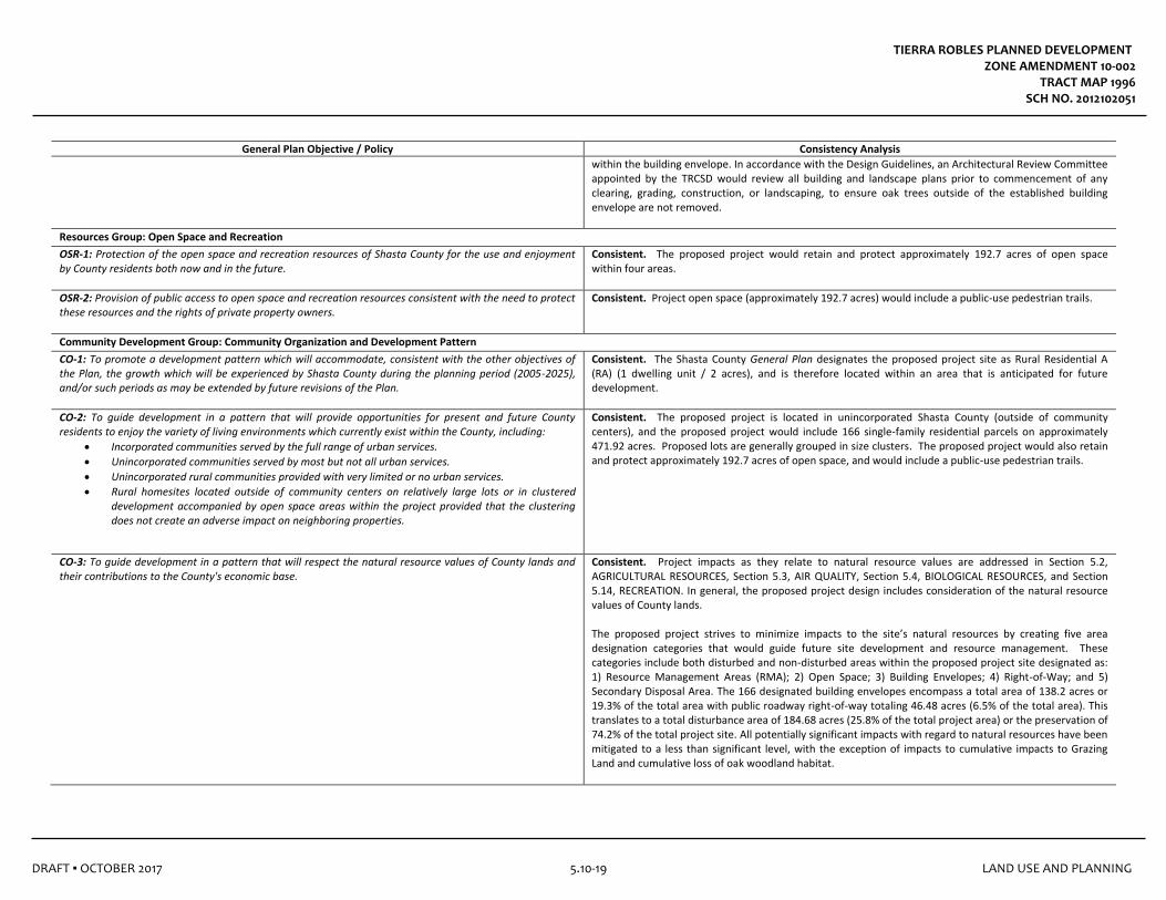
General Plan Objective / Policy Consistency Analysis
within the building envelope. In accordance with the Design Guidelines, an Architectural Review Committee appointed by the TRCSD would review all building and landscape plans prior to commencement of any clearing, grading, construction, or landscaping, to ensure oak trees outside of the established building envelope are not removed.
Resources Group: Open Space and Recreation
OSR-1: Protection of the open space and recreation resources of Shasta County for the use and enjoyment by County residents both now and in the future.
Consistent. The proposed project would retain and protect approximately 192.7 acres of open space within four areas.
OSR-2: Provision of public access to open space and recreation resources consistent with the need to protect these resources and the rights of private property owners.
Consistent. Project open space (approximately 192.7 acres) would include a public-use pedestrian trails.
Community Development Group: Community Organization and Development Pattern
CO-1: To promote a development pattern which will accommodate, consistent with the other objectives of the Plan, the growth which will be experienced by Shasta County during the planning period (2005-2025), and/or such periods as may be extended by future revisions of the Plan.
Consistent. The Shasta County General Plan designates the proposed project site as Rural Residential A (RA) (1 dwelling unit / 2 acres), and is therefore located within an area that is anticipated for future development.
CO-2: To guide development in a pattern that will provide opportunities for present and future County residents to enjoy the variety of living environments which currently exist within the County, including:
• Incorporated communities served by the full range of urban services.
• Unincorporated communities served by most but not all urban services.
• Unincorporated rural communities provided with very limited or no urban services.
• Rural homesites located outside of community centers on relatively large lots or in clustered development accompanied by open space areas within the project provided that the clustering does not create an adverse impact on neighboring properties.
Consistent. The proposed project is located in unincorporated Shasta County (outside of community centers), and the proposed project would include 166 single-family residential parcels on approximately 471.92 acres. Proposed lots are generally grouped in size clusters. The proposed project would also retain and protect approximately 192.7 acres of open space, and would include a public-use pedestrian trails.
CO-3: To guide development in a pattern that will respect the natural resource values of County lands and their contributions to the County's economic base.
Consistent. Project impacts as they relate to natural resource values are addressed in Section 5.2, AGRICULTURAL RESOURCES, Section 5.3, AIR QUALITY, Section 5.4, BIOLOGICAL RESOURCES, and Section 5.14, RECREATION. In general, the proposed project design includes consideration of the natural resource values of County lands. The proposed project strives to minimize impacts to the site’s natural resources by creating five area designation categories that would guide future site development and resource management. These categories include both disturbed and non-disturbed areas within the proposed project site designated as: 1) Resource Management Areas (RMA); 2) Open Space; 3) Building Envelopes; 4) Right-of-Way; and 5) Secondary Disposal Area. The 166 designated building envelopes encompass a total area of 138.2 acres or 19.3% of the total area with public roadway right-of-way totaling 46.48 acres (6.5% of the total area). This translates to a total disturbance area of 184.68 acres (25.8% of the total project area) or the preservation of 74.2% of the total project site. All potentially significant impacts with regard to natural resources have been mitigated to a less than significant level, with the exception of impacts to cumulative impacts to Grazing Land and cumulative loss of oak woodland habitat.
TIERRA ROBLES PLANNED DEVELOPMENT ZONE AMENDMENT 10-002
TRACT MAP 1996 SCH NO. 2012102051
DRAFT ▪ OCTOBER 2017 5.10-20 LAND USE AND PLANNING
General Plan Objective / Policy Consistency Analysis
CO-4: To guide development in a pattern that will minimize land use conflicts between adjacent land users. Consistent. The proposed project would result in an orderly pattern of growth that is anticipated in the County’s adopted General Plan.
CO-6: To fashion a development pattern whose implementation mechanisms such as zoning, subdivision, and other regulations, explicitly define a relationship between public and private expectations and responsibilities concerning land use that is based on the following principles:
• Public programs shall recognize both the expectations of individual property owners to be able to use their lands as they desire, and the responsibility of government to provide a regulatory climate which does not impede reasonable private expectations.
• Property owners shall recognize public programs emphasizing that land be used in a responsible manner that does not adversely affect either adjacent property owners, the County's fiscal ability to provide services, or the community values of the citizens of Shasta County.
• A workable relationship between public and private land use expectations must be achieved in order for each to be well served.
• Periodic review of the relationship between public and private land use expectations is necessary to reflect changing community values.
Consistent. The Planned Development (PD) zoning designation establishes a detailed development pattern and implementation mechanisms.
CO-7: To recognize that the major economic resources for achieving the development pattern will come from the private sector, rather than government, and that the General Plan, as the expression of community values, will guide the use of these resources.
Consistent. The proposed project would be privately funded and, subject to concurrence by the County Board of Supervisors, the proposed land use would be consistent with General Plan guidelines.
CO-h: A land capability analysis demonstrating that criteria in the County Development Standards will be met shall be used to establish actual residential densities and parcel sizes for all development projects including lands proposed for General Plan or zone amendments which increase the residential density. The development standards should be periodically reviewed and revised to further refine the application of the land capability analysis concept.
Consistent. This Draft EIR serves the function of performing the land capability analysis.
CO-i: The Rural Residential A (RA) designation shall be primarily applied to rural community centers and urban and towncenter fringes in order to accommodate residential development. The RA designation around community centers shall be expanded at a rate consistent with policies CO-b, CO-c, and CO-d.
Consistent. The proposed project is located within the South Central Region Planning Area. Chapter 3 of the County’s General Plan identifies three distinct types of communities: Urban Center, Town Center, and Rural Community Center. The proposed project site is not within any of these community types, however, it located near Bella Vista (Rural Center) and Palo Cedro (Town Center). The Shasta County General Plan designates the proposed project site as Rural Residential A (RA) (1 dwelling unit / 2 acres).
Community Development Group: Circulation
C6-a: Future road and street development including future right-of-way shall comply with the adopted County Development Standards.
Consistent. Project design would comply with the adopted County Development Standards.
C-6j: New development shall provide circulation improvements for emergency access by police, fire, and medical vehicles; and shall provide for escape by residents/occupants in accordance with the Fire Safety
Consistent. Project design would comply with the adopted County Development Standards. Circulation is described in Section 5.16, TRAFFIC AND CIRCULATION. The proposed connection with Northgate Road
TIERRA ROBLES PLANNED DEVELOPMENT ZONE AMENDMENT 10-002
TRACT MAP 1996 SCH NO. 2012102051
DRAFT ▪ OCTOBER 2017 5.10-21 LAND USE AND PLANNING
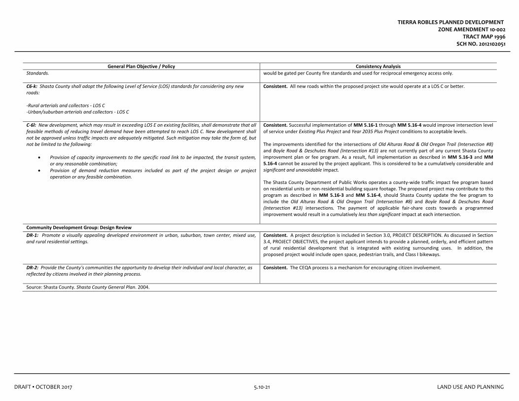
General Plan Objective / Policy Consistency Analysis
Standards. would be gated per County fire standards and used for reciprocal emergency access only.
C6-k: Shasta County shall adopt the following Level of Service (LOS) standards for considering any new roads: -Rural arterials and collectors - LOS C -Urban/suburban arterials and collectors - LOS C
Consistent. All new roads within the proposed project site would operate at a LOS C or better.
C-6l: New development, which may result in exceeding LOS E on existing facilities, shall demonstrate that all feasible methods of reducing travel demand have been attempted to reach LOS C. New development shall not be approved unless traffic impacts are adequately mitigated. Such mitigation may take the form of, but not be limited to the following:
• Provision of capacity improvements to the specific road link to be impacted, the transit system, or any reasonable combination;
• Provision of demand reduction measures included as part of the project design or project operation or any feasible combination.
Consistent. Successful implementation of MM 5.16-1 through MM 5.16-4 would improve intersection level of service under Existing Plus Project and Year 2035 Plus Project conditions to acceptable levels. The improvements identified for the intersections of Old Alturas Road & Old Oregon Trail (Intersection #8) and Boyle Road & Deschutes Road (Intersection #13) are not currently part of any current Shasta County improvement plan or fee program. As a result, full implementation as described in MM 5.16-3 and MM 5.16-4 cannot be assured by the project applicant. This is considered to be a cumulatively considerable and significant and unavoidable impact.
The Shasta County Department of Public Works operates a county-wide traffic impact fee program based on residential units or non-residential building square footage. The proposed project may contribute to this program as described in MM 5.16-3 and MM 5.16-4, should Shasta County update the fee program to include the Old Alturas Road & Old Oregon Trail (Intersection #8) and Boyle Road & Deschutes Road (Intersection #13) intersections. The payment of applicable fair-share costs towards a programmed improvement would result in a cumulatively less than significant impact at each intersection.
Community Development Group: Design Review
DR-1: Promote a visually appealing developed environment in urban, suburban, town center, mixed use, and rural residential settings.
Consistent. A project description is included in Section 3.0, PROJECT DESCRIPTION. As discussed in Section 3.4, PROJECT OBJECTIVES, the project applicant intends to provide a planned, orderly, and efficient pattern of rural residential development that is integrated with existing surrounding uses. In addition, the proposed project would include open space, pedestrian trails, and Class I bikeways.
DR-2: Provide the County's communities the opportunity to develop their individual and local character, as reflected by citizens involved in their planning process.
Consistent. The CEQA process is a mechanism for encouraging citizen involvement.
Source: Shasta County. Shasta County General Plan. 2004.
TIERRA ROBLES PLANNED DEVELOPMENT ZONE AMENDMENT 10-002
TRACT MAP 1996 SCH NO. 2012102051
DRAFT ▪ OCTOBER 2017 5.10-22 LAND USE AND PLANNING
5.10.5 CUMULATIVE SETTING, IMPACTS, AND MITIGATION MEASURES
IMPACT 5.10-2
Implementation of the proposed project, combined with other past, present, and reasonably foreseeable future development, would not physically divide an established community, conflict with any applicable land use plan, policy, or regulation, or conflict with any applicable habitat or natural community conservation plan.
Significance: Less Than Significant Impact. Cumulative Setting: The geographic scope for cumulative impacts related to land use includes closely related past, present, and reasonably foreseeable future projects located in the surrounding area. The area influenced by cumulative land use effects related to adjacent parcels and the surrounding planned development areas is described in Section 4.0, BASIS OF CUMULATIVE ANALYSIS. Related land use projects in the surrounding areas have been: 1) submitted for plan processing; 2) approved by Shasta County; and/or 3) engaged in active construction programs. While the surrounding area is not at buildout, and is undeveloped to the north, the proposed project would contribute to a cumulative influence on land uses in and around the project area. Impact Analysis: With regard to conflicts with any land use plan, policies, or regulations, approval of the proposed project and implementation of the proposed mitigation measures identified in this Draft EIR would ensure that the proposed project complies with applicable goals, policies, and regulations implemented by the County. Less than significant impacts are anticipated at the project level. With regard to cumulative impacts, as shown in Table 4-1 in Section 4.0, BASIS OF CUMMULATIVE ANALYSIS, the cumulative projects considered include residential developments, as well as miscellaneous smaller-scale land development projects in the surrounding local vicinity. Potential land use impacts may include inconsistencies with the Shasta County General Plan or Shasta County Zoning Plan, as well as incompatibilities with existing land uses in the vicinity of a proposed development. The proposed project would not introduce a new land use type in the project area, and would not conflict with the operation of surrounding land uses. Potential land use impacts are site-specific and require evaluation on a case-by-case basis. This is true with regard to land use compatibility impacts, which are generally a function of the relationship between the interactive effects of a specific development site and those of its immediate environment. Future development of surrounding lands is anticipated to occur in accordance with the Shasta County General Plan and in accordance with Shasta County Zoning Plan, unless otherwise approved by the County. The land use impacts in conjunction with cumulative development would generally increase residential-type uses in the study area. The proposed project would develop the project site with a land use anticipated by the Shasta County General Plan and would not conflict with existing land use plans, policies, or regulations or other applicable plans or policies as described above under Impact 5.10-1. The County would require review of all future land development within the project area through the discretionary permit process (and/or to ensure conformance with County development standards and regulations) to demonstrate consistency with the General Plan (as applicable) and Zoning Plan. In addition, the proposed project would not
TIERRA ROBLES PLANNED DEVELOPMENT ZONE AMENDMENT 10-002
TRACT MAP 1996 SCH NO. 2012102051
DRAFT ▪ OCTOBER 2017 5.10-23 LAND USE AND PLANNING
physically divide a community (or contribute to such cumulative effects on a community), as the proposed project is located in a rural residential portion of the County. As the proposed project would not result in significant land use or planning impacts, it would not contribute to an overall cumulative land use impact in the area. Thus, potential cumulative effects would be less than cumulatively considerable. Similarly, planned or future projects in the area would also be subject to applicable federal, State, and local regulations to ensure that land use conflicts do not occur. Any such impacts would be reduced through the implementation of mitigation measures, as appropriate, and subject to County review and approval. Impacts of the proposed project would combine with impacts of past, present, and reasonably foreseeable projects to result in a less than significant cumulative impact. Mitigation Measures: No mitigation measures are required. Level of Significance After Mitigation: No mitigation measures are required. Cumulative impacts related to land use and planning would be less than significant.