+ All Categories
Home > Documents > 530000 532000 534000 536000 538000 Ü - southwark.gov.uk

530000 532000 534000 536000 538000 Ü - southwark.gov.uk

Date post: 09-Jan-2022
Category:
Upload: others
View: 4 times
Download: 0 times
Share this document with a friend
1
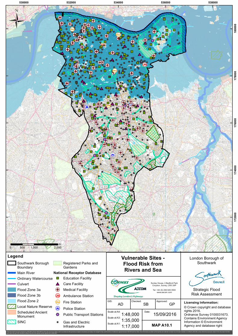
530000 532000 534000 536000 538000 172000 174000 176000 178000 180000 Sunley House, 4 Bedford Park Croydon, Surrey, CR0 2AP Tel: +44 (0) 208 639 3500 www.aecom.com Ü 0 1,000 2,000 500 m Licensing Information: Vulnerable Sites - Flood Risk from Rivers and Sea "This document has been prepared by AECOM Limited ("AECOM") for the sole use of our Client, and in accordance with generally accepted consultancy principles, the budget for fees and the terms of reference agreed between AECOM and the Client. Any information provided by third parties and referred to herein has not been checked or verified by AECOM, unless otherwise expressly stated in the document. No third party may rely upon this document without the prior and express written agreement of AECOM." © Crown copyright and database rights 2016. Ordnance Survey 0100031673. Contains Environment Agency Information © Environment Agency and database right Legend Southwark Borough Boundary Main River Ordinary Watercourse Culvert Flood Zone 3a Flood Zone 3b Flood Zone 2 Local Nature Reserve Scheduled Ancient Monument SINC Registered Parks and Gardens National Receptor Database " C Education Facility # B Care Facility " ' Medical Facility " C & Ambulance Station " Y & Fire Station " g $ Police Station ! A Public Transport Stations ! A Gas and Electric Infrastructure London Borough of Southwark Strategic Flood Risk Assessment 1:35,000 Checked: GIS: Approved: AD SB GP MAP A10.1 Scale at A4: Date: 1:48,000 15/09/2016 Scale at A3: Scale at A1: 1:17,000
Transcript

530000 532000 534000 536000 538000

1720

0017

4000

1760

0017

8000

1800

00

Sunley House, 4 Bedford ParkCroydon, Surrey, CR0 2APTel: +44 (0) 208 639 3500

www.aecom.com

Ü

0 1,000 2,000500m

Licensing Information:

Vulnerable Sites -Flood Risk fromRivers and Sea

"This document has been prepared by AECOM Limited ("AECOM") for the sole use of our Client, and in accordance with generally accepted consultancy principles, the budget for fees and the terms of reference agreed between AECOM and the Client. Any information provided by third parties and referred to herein has not been checked or verified by AECOM, unless otherwise expressly stated in the document. No thirdparty may rely upon this document without the prior and express written agreement of AECOM."

© Crown copyright and databaserights 2016.Ordnance Survey 0100031673.Contains Environment AgencyInformation © Environment Agency and database right

LegendSouthwark Borough BoundaryMain RiverOrdinary WatercourseCulvertFlood Zone 3aFlood Zone 3bFlood Zone 2Local Nature ReserveScheduled Ancient MonumentSINC

Registered Parks and Gardens

National Receptor Database"C Education Facility#B Care Facility"' Medical Facility"C& Ambulance Station"Y& Fire Station"g$ Police Station!A Public Transport Stations!A Gas and Electric

Infrastructure

London Borough ofSouthwark

Strategic FloodRisk Assessment

1:35,000

Checked:GIS: Approved:AD SB GP

MAP A10.1

Scale at A4: Date:1:48,000 15/09/2016Scale at A3:

Scale at A1: 1:17,000

Recommended