+ All Categories
Home > Documents > Æ·542 - wdfw.wa.gov · PDF filett33 44rr04ee t30r066e t32r055e t3377rr0066ee...

Æ·542 - wdfw.wa.gov · PDF filett33 44rr04ee t30r066e t32r055e t3377rr0066ee...

Date post: 06-Mar-2018
Category:
Upload: lamtruc
View: 216 times
Download: 2 times
Share this document with a friend
2
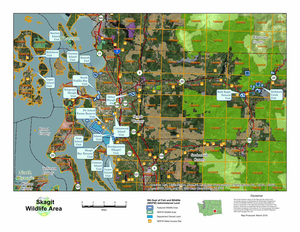
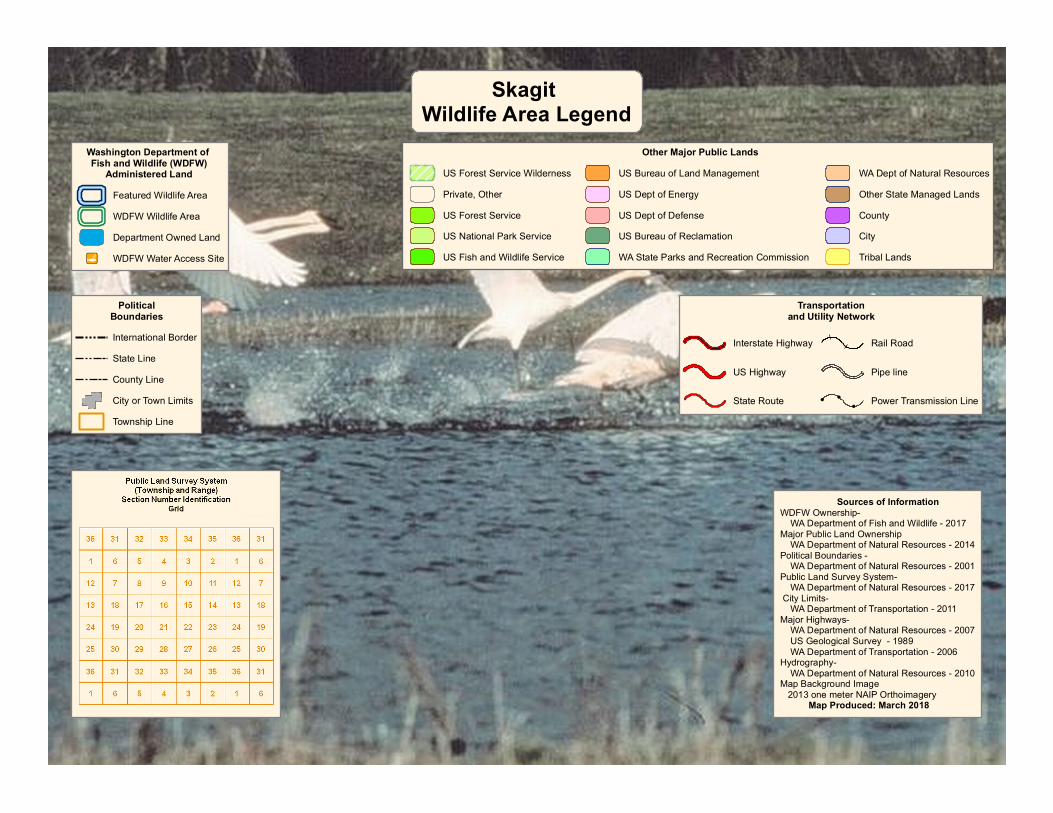
^ WA Dept of Fish and Wildlife (WDFW) Administered Land Featured Wildlife Area WDFW Wildlife Area Department Owned Land ! l " WDFW Water Access Site ! l " ! l " ! l " ! l " ! l " ! l " ! l " ! l " ! l " ! l " ! l " ! l " ! l " ! l " ! l " ! l " ! l " ! l " ! l " ! l " ! l " ! l " ! l " ! l " ! l " ! l " ! l " ! l " ! l " ! l " ! l " ! l " ! l " ! l " ! l " ! l " ! l " ! l " ! l " ! l " ! l " ! l " ! l " ! l " ! l " ! l " ! l " ! l " ! l " ! l " ! l " ! l " ! l " ! l " ! l " ! l " ! l " ! l " ! l " ! l " ! l " ! l " ! l " ! l " ! l " ! l " ! l " ! l " ! l " Jackman Creek Unit Bald Eagle Natural Unit Leque Island Unit Fir Island Farms Reserve Unit Goat Island Unit Telegraph Slough Unit Debay Slough Unit Samish Unit Guemes Island Unit Sinclair Island Unit Lopez Island Unit Cottonwood Island Unit Camano Island Unit Skagit Bay Estuary Unit Island Unit Headquarters (Skagit) Unit South Padilla Bay Unit Killebrew Unit Æ · 11 Æ · 531 Æ · 536 Æ · 534 Æ · 20 Æ · 542 Æ · 20 Æ · 532 Æ · 9 Æ · 525 Æ · 538 Æ · 9 Æ · 20 Æ · 530 Æ · 530 % & ' ( 5 Whatcom County Skagit County Island County Snohomish County Jefferson County Clallam County T33R02E T33R02E T32R03E T32R03E T38R10E T38R10E T32R01E T32R01E T30R04E T30R04E T31R10E T31R10E T37R10E T37R10E T37R11E T37R11E T35R03E T35R03E T36R03E T36R03E T34R02E T34R02E T33R03E T33R03E T37R08E T37R08E T34R03E T34R03E T36R10E T36R10E T37R09E T37R09E T36R09E T36R09E T38R08E T38R08E T30R09E T30R09E T35R08E T35R08E T31R11E T31R11E T36R11E T36R11E T30R10E T30R10E T35R10E T35R10E T30R11E T30R11E T36R05E T36R05E T38R09E T38R09E T34R08E T34R08E T31R09E T31R09E T38R11E T38R11E T31R08E T31R08E T32R04E T32R04E T35R02W T35R02W T34R02W T34R02W T38R05E T38R05E T34R07E T34R07E T30R05E T30R05E T30R01W T30R01W T34R09E T34R09E T37R04E T37R04E T32R10E T32R10E T31R04E T31R04E T35R09E T35R09E T32R07E T32R07E T31R01E T31R01E T38R04E T38R04E T33R09E T33R09E T36R04E T36R04E T35R11E T35R11E T34R04E T34R04E T30R06E T30R06E T32R05E T32R05E T37R06E T37R06E T30R07E T30R07E T33R10E T33R10E T35R04E T35R04E T37R01W T37R01W T37R03E T37R03E T38R06E T38R06E T34R11E T34R11E T33R11E T33R11E T33R07E T33R07E T33R08E T33R08E T32R11E T32R11E T35R06E T35R06E T38R03E T38R03E T33R04E T33R04E T33R05E T33R05E T38R02E T38R02E T34R05E T34R05E T34R06E T34R06E T35R05E T35R05E T33R01E T33R01E T36R01W T36R01W T31R07E T31R07E T38R07E T38R07E T37R02W T37R02W T35R07E T35R07E T36R07E T36R07E T37R05E T37R05E T36R06E T36R06E T33R06E T33R06E T36R08E T36R08E T37R07E T37R07E T36R02W T36R02W T32R08E T32R08E T35R01E T35R01E T31R05E T31R05E T32R09E T32R09E T34R10E T34R10E T32R06E T32R06E T31R06E T31R06E T30R08E T30R08E Whatcom North Olympic Source: Esri, DigitalGlobe, GeoEye, Earthstar Geographics, CNES/Airbus DS, USDA, USGS, AeroGRID, IGN, and the GIS User Community, WDFW 0 3 6 9 12 Miles Map Produced: March 2018 Wildlife Area Skagit Due to the dynamic nature of the data and the need to rely on outside sources of information the Washington Department of Fish and Wildlife (WDFW) cannot accept responsibility for errors or omissions in the data and information contained in this product. There are no warranties that accompany the maps and information contained in this product. For more accurate information concerning this Wildlife Area Unit contact the WDFW Regional office that manages this unit. Disclaimer
Transcript

^

WA Dept of Fish and Wildlife(WDFW) Administered Land

Featured Wildlife AreaWDFW Wildlife AreaDepartment Owned Land

!!l" WDFW Water Access Site

!!l"

!!l"

!!l"

!!l"

!!l"

!!l"

!!l"!!l"

!!l"

!!l"

!!l"

!!l"!!l"

!!l"!!l"

!!l"!!l"

!!l"

!!l"

!!l"!!l"

!!l"

!!l"

!!l"!!l"

!!l"

!!l"

!!l"

!!l"!!l"

!!l"

!!l"

!!l"

!!l"

!!l"

!!l"

!!l"!!l"

!!l"

!!l"

!!l"

!!l"

!!l"!!l"

!!l"

!!l"

!!l"

!!l"

!!l"

!!l"

!!l"

!!l"

!!l"

!!l"

!!l"

!!l"

!!l"!!l"

!!l"

!!l"!!l"

!!l"

!!l"!!l"

!!l"

!!l"

!!l"

!!l"

!!l"

!!l"

JackmanCreekUnit

Bald EagleNatural

Unit

LequeIslandUnit

Fir IslandFarms Reserve

Unit

GoatIslandUnit

TelegraphSlough

Unit DebaySlough

Unit

SamishUnit

GuemesIslandUnit

SinclairIsland

Unit

LopezIslandUnit

CottonwoodIslandUnit

CamanoIsland

Unit

SkagitBay Estuary

Unit

IslandUnit

Headquarters(Skagit)

Unit

SouthPadilla Bay

Unit

KillebrewUnit Æ·11

Æ·531

Æ·536

Æ·534

Æ·20

Æ·542

Æ·20

Æ·532

Æ·9

Æ·525

Æ·538

Æ·9Æ·20

Æ·530

Æ·530

%&'(5

WhatcomCounty

SkagitCounty

IslandCounty

SnohomishCounty

JeffersonCounty

ClallamCounty

T33R02ET33R02E

T32R03ET32R03E

T38R10ET38R10E

T32R01ET32R01E

T30R04ET30R04E

T31R10ET31R10E

T37R10ET37R10ET37R11ET37R11E

T35R03ET35R03E

T36R03ET36R03E

T34R02ET34R02E

T33R03ET33R03E

T37R08ET37R08E

T34R03ET34R03E

T36R10ET36R10E

T37R09ET37R09E

T36R09ET36R09E

T38R08ET38R08E

T30R09ET30R09E

T35R08ET35R08E

T31R11ET31R11E

T36R11ET36R11E

T30R10ET30R10E

T35R10ET35R10E

T30R11ET30R11E

T36R05ET36R05E

T38R09ET38R09E

T34R08ET34R08E

T31R09ET31R09E

T38R11ET38R11E

T31R08ET31R08E

T32R04ET32R04E

T35R02WT35R02W

T34R02WT34R02W

T38R05ET38R05E

T34R07ET34R07E

T30R05ET30R05ET30R01WT30R01W

T34R09ET34R09E

T37R04ET37R04E

T32R10ET32R10E

T31R04ET31R04E

T35R09ET35R09E

T32R07ET32R07E

T31R01ET31R01E

T38R04ET38R04E

T33R09ET33R09E

T36R04ET36R04E

T35R11ET35R11E

T34R04ET34R04E

T30R06ET30R06E

T32R05ET32R05E

T37R06ET37R06E

T30R07ET30R07E

T33R10ET33R10E

T35R04ET35R04E

T37R01WT37R01WT37R03ET37R03E

T38R06ET38R06E

T34R11ET34R11E

T33R11ET33R11ET33R07ET33R07E T33R08ET33R08E

T32R11ET32R11E

T35R06ET35R06E

T38R03ET38R03E

T33R04ET33R04ET33R05ET33R05E

T38R02ET38R02E

T34R05ET34R05E T34R06ET34R06E

T35R05ET35R05E

T33R01ET33R01E

T36R01WT36R01W

T31R07ET31R07E

T38R07ET38R07E

T37R02WT37R02W

T35R07ET35R07E

T36R07ET36R07E

T37R05ET37R05E

T36R06ET36R06E

T33R06ET33R06E

T36R08ET36R08E

T37R07ET37R07E

T36R02WT36R02W

T32R08ET32R08E

T35R01ET35R01E

T31R05ET31R05E

T32R09ET32R09E

T34R10ET34R10E

T32R06ET32R06E

T31R06ET31R06E

T30R08ET30R08E

Whatcom

NorthOlympic

Source: Esri, DigitalGlobe, GeoEye, Earthstar Geographics, CNES/Airbus DS, USDA, USGS,AeroGRID, IGN, and the GIS User Community, WDFW

0 3 6 9 12

Miles

Map Produced: March 2018

Wildlife AreaSkagit Due to the dynamic nature of the data and the need to rely

on outside sources of information the Washington Department of Fish and Wildlife (WDFW) cannot accept responsibility for errors or omissions in the data and information contained in this product. There are no warranties that accompany the maps and information contained in this product. For more accurate information concerning this Wildlife Area Unit contact the WDFW Regional office that manages this unit.

Disclaimer

PoliticalBoundariesInternational BorderState LineCounty LineCity or Town LimitsTownship Line

Transportationand Utility Network

Interstate Highway

US Highway

State Route

Rail Road

Pipe line

!

!

!Power Transmission Line

Washington Department of Fish and Wildlife (WDFW)

Administered LandFeatured Wildlife AreaWDFW Wildlife AreaDepartment Owned Land

!!l" WDFW Water Access Site

Other Major Public LandsUS Forest Service WildernessPrivate, OtherUS Forest ServiceUS National Park ServiceUS Fish and Wildlife Service

US Bureau of Land ManagementUS Dept of EnergyUS Dept of DefenseUS Bureau of ReclamationWA State Parks and Recreation Commission

WA Dept of Natural ResourcesOther State Managed LandsCountyCityTribal Lands

Skagit Wildlife Area Legend

Sources of InformationWDFW Ownership- WA Department of Fish and Wildlife - 2017Major Public Land Ownership WA Department of Natural Resources - 2014Political Boundaries - WA Department of Natural Resources - 2001Public Land Survey System- WA Department of Natural Resources - 2017 City Limits- WA Department of Transportation - 2011Major Highways- WA Department of Natural Resources - 2007 US Geological Survey - 1989 WA Department of Transportation - 2006Hydrography- WA Department of Natural Resources - 2010Map Background Image 2013 one meter NAIP Orthoimagery Map Produced: March 2018


Recommended