28
55061_12_Ch12_p320_347 pp2.indd 32055061_12_Ch12_p320_347 pp2.indd 320 6/5/08 4:28:39 PM6/5/08 4:28:39 PM

12Soils and Soil Development
Soil is an outstanding example of the interrelationships among Earth’s subsystems.
Why is soil such a good example of the interaction and integra-tion of subsystems?Why should soil be considered an open system?
Soil water is the means by which plants receive dissolved nutri-ents that are essential for growth.
Why is gravitational water such an effective agent of solution?How is capillary water important during periods of drought?
Soil fertility depends on many factors, and a soil that is fertile for one vegetation type may not be for another.
What factors determine a soil’s fertility, and how is vegetation involved?How are acidity and alkalinity related to soil fertility?
On a global scale, climate exerts a major infl uence on the formation and characteristics of soils.
How do temperature, precipitation, and moisture regimes affect the development of soils?Why is the regional distribution of soils similar to regions of climate and vegetation?
Soils are among the world’s most critical and widely abused yet least understood natural resources.
How are soils abused or neglected as a resource?What can be done to conserve soils?
■
■
■
■
■
■
■
■
■
■
CHAPTER PREVIEW
W hat are the four most important natural
constituents that permit life as we know it to exist
on Earth? Many people if asked that question would reply,
“air, water, and sunlight,” right away, but they might have
to think harder and longer about their fourth answer. Most
people give little attention to that fourth natural resource,
but it is essential for their life on Earth, and it lies right below
their feet. Soil is that critical resource. The soil mantle that
covers most land surfaces is indispensable, but fragile, and
threatened by erosion, pollution, or being covered over by
the human-built environment. Soil provides nutrients that
directly or indirectly support much of life on Earth.
Soil is a dynamic natural body capable of supporting
a vegetative cover. It contains chemical solutions, gases,
organic refuse, flora, and fauna. The physical, chemical, and
biological processes that take place among the components
of a soil are integral parts of its dynamic character. Soil
responds to climatic conditions (especially temperature and
moisture), to the land surface configuration, to vegetative
cover and composition, and to animal activity.
Soil has been called “the skin of the Earth.” The
condition and nature of a soil reflects both the ancient
environments under which it formed, and today’s
environmental conditions. A soil functions as an
environmental system, adapting, reflecting, and responding
Opposite: Scientists work to understand and control erosional losses and other problems that threaten our precious natural resource—soil.USDA/ARS/Photo by Jack Dykinga
▼
321
55061_12_Ch12_p320_347 pp2.indd 32155061_12_Ch12_p320_347 pp2.indd 321 6/5/08 4:28:45 PM6/5/08 4:28:45 PM

C H A P T E R 1 2 • S O I L S A N D S O I L D E V E L O P M E N T322
to a great variety of natural and human-influenced processes. Soil is an exceptional example of the integration, interdependence, and overlap among Earth’s subsystems because the characteristics of a soil reflect the atmospheric, hydrologic, lithologic, and biotic con-ditions under which it developed ( ● Fig. 12.1). In fact, because soils integrate these major subsystems so well, they are sometimes considered a separate system called the pedosphere (from Greek: pedon, ground).
Soil is also home to numerous living organisms, forming the environments in which they live, both above and below the ground surface. The life-forms that live in or on a soil play sig-nificant roles in the development and characteristics of a soil, and through human population growth and expanding civi-lizations, potentially negative impacts on soils have increased dramatically.
How a soil develops and its resulting characteristics depend on a great number of factors. But when soils are viewed on a world regional scale, a strong and significant influence is climate. The relationships between soils, climate types, and their associated environments were considered in Chapters 9 and 10.
Major Soil ComponentsWhat is soil actually made of ? What does a shovel contain when it scoops up a load of soil? What soil characteristics support and in-fluence variations in Earth’s vegetational environments? Soils con-tain four major components, and there are many processes that act on these components. The four major components of soil are inor-ganic materials, soil water, soil air, and organic matter ( ● Fig. 12.2).
Inorganic MaterialsSoils contain varying amounts of insoluble materials—rock frag-ments and minerals that will not readily dissolve in water. Soils also contain soluble minerals, which supply dissolved chemicals held in solution. Most minerals found in soils are combinations
of the common elements of Earth’s surface rocks: silicon, alumi-num, oxygen, and iron. Some of these constituents occur as solid chemical compounds, and others are found in the air and water that are also vital components of a soil. Soils sustain Earth’s land
Microcoloniesof bacteria
QuartzQuartz
Quartz
Air
Air
Clay particle
Clay particle
Organicmatter
H2O
● FIGURE 12.2The four major components of soil. Soil contains a complex assemblage of inorganic minerals and rocks, along with water, air, and organic matter. The interaction among these components and the proportion of each are important factors in the development of a soil.How do each of these soil components contribute to making a soil suitable to support plant life?
HydrosphereBiosphere
Atmosphere
Lithosphere
SOIL
● FIGURE 12.1The intertwined links between soil and the major Earth subsystems.Why is soil considered to be such an integrator of Earth systems?
● FIGURE 12.3Fertilizers increase the productivity of soils. This farmer is adding nitrogen fertilizer into the soil on this Iowa farm.Why can soil fertilizer be either useful or detrimental when it is introduced into the soil system?
USDA
/NRC
S/Ly
nn B
etts
From
Pur
ves,
et a
l., L
ife: T
he S
cien
ce o
f Bio
logy
, Fou
rth E
ditio
n. U
sed
with
pe
rmis
sion
of S
inau
er A
ssoc
iate
s, In
c.
55061_12_Ch12_p320_347 pp2.indd 32255061_12_Ch12_p320_347 pp2.indd 322 6/5/08 4:28:46 PM6/5/08 4:28:46 PM
323
ecosystems by providing a great variety of necessary chemical ele-ments and compounds to life-forms. Carbon, hydrogen, nitrogen, sodium, potassium, zinc, copper, iodine, and compounds of these elements are important in soils. The chemical constituents of a soil typically come from many sources—the breakdown (weather-ing) of underlying rocks, deposits of loose sediments, and minerals dissolved in water. Organic activities help to disintegrate rocks, create new chemical compounds, and release gases into the soil.
Plants need many chemical substances for growth, and hav-ing a knowledge of a soil’s mineral and chemical content is neces-sary for determining its potential productivity. Soil fertilization is the process of adding nutrients or other constituents in order to meet the soil conditions that certain plants require ( ● Fig. 12.3).
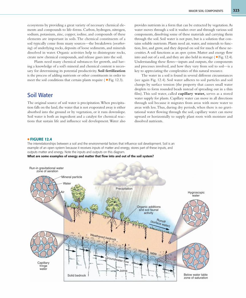
Soil WaterThe original source of soil water is precipitation. When precipita-tion falls on the land, the water that is not evaporated away is either absorbed into the ground or by vegetation, or it runs downslope. Soil water is both an ingredient and a catalyst for chemical reac-tions that sustain life and influence soil development. Water also
provides nutrients in a form that can be extracted by vegetation. As water moves through a soil it washes over and through various soil components, dissolving some of these materials and carrying them through the soil. Soil water is not pure, but is a solution that con-tains soluble nutrients. Plants need air, water, and minerals to func-tion, live, and grow, and they depend on soil for much of these ne-cessities. A soil functions as an open system. Matter and energy flow into and out of a soil, and they are also held in storage ( ● Fig. 12.4). Understanding these flows—inputs and outputs, the components and processes involved, and how they vary from soil to soil—is a key to appreciating the complexities of this natural resource.
The water in a soil is found in several different circumstances (see again Fig. 12.4). Soil water adheres to soil particles and soil clumps by surface tension (the property that causes small water droplets to form rounded beads instead of spreading out in a thin film). This soil water, called capillary water, serves as a stored water supply for plants. Capillary water can move in all directions through soil because it migrates from areas with more water to areas with less. Thus, during dry periods, when there is no gravi-tational water flowing through the soil, capillary water can move upward or horizontally to supply plant roots with moisture and dissolved nutrients.
MAJOR SOIL COMPONENTS
Precipitation
Organic additionsand soil faunal
activity
Mineral particle
Run-in gravitational waterzone of aeration
Water
Air Hygroscopicwater
Below water tablezone of saturation
Capillaryfringewater
Solid bedrock
Joints
Water tableGroundwater flow
Runoff(surface water)
Weathered bedrock
● FIGURE 12.4The interrelationships between a soil and the environmental factors that influence soil development. Soil is an example of an open system because it receives inputs of matter and energy, stores part of these inputs, and outputs matter and energy. Note the inputs and outputs on this diagram.What are some examples of energy and matter that flow into and out of the soil system?
55061_12_Ch12_p320_347 pp2.indd 32355061_12_Ch12_p320_347 pp2.indd 323 6/5/08 4:28:47 PM6/5/08 4:28:47 PM

C H A P T E R 1 2 • S O I L S A N D S O I L D E V E L O P M E N T324
Capillary water migrates upward and moves minerals from the subsoil toward the surface. If this capillary water evaporates away, the formerly dissolved minerals remain, generally as alkaline or saline deposits in the topsoil. High concentrations of certain mineral deposits, like these, can be detrimental to plants and ani-mals existing in the soil. Lime (calcium carbonate) deposited by evaporating soil water can build up to produce a cementlike layer, called caliche, which like a clay hardpan prevents the downward percolation of water.
Soil water is also found as a very thin film, invisible to the naked eye, that is bound to the surfaces of soil particles by strong electrical forces. This is hygroscopic water, which does not move through the soil, and it also does not supply plants with the moisture that they need.
Water that percolates down through a soil, under the force of gravity, is called gravitational water. Gravitational water moves downward through voids between soil particles and toward the water table—the level below which all available spaces are filled with water. The quantity of gravitational water in a soil is related to several conditions, including the amount of precipitation, the time since it fell, evaporation rates, the space available for water storage, and how easily the water can move through the soil.
Gravitational water performs several functions in a soil ( ● Fig. 12.5). As gravitational water percolates downward, it dis-solves soluble minerals and carries them into deeper levels of the soil, perhaps to the zone where all open spaces are satu-rated. Depleting nutrients in the soil by the through flow of water is called leaching. In regions of heavy rainfall, leaching
is common and can be intense, robbing a topsoil of all but the insoluble substances.
Gravitational water moving down through a soil also takes with it the finer particles (clay and silt) from the upper soil layers. This downward removal of soil components by water is called eluviation. As gravitational water percolates downward, it de-posits the fine materials that were removed from the topsoil at a lower level in the soil. Deposition by water in the subsoil is called illuviation. Gravitational water also mixes soil particles as it moves them downward. One result of eluviation is that the texture of a topsoil tends to become coarser as the fine particles are removed. Consequently, the topsoil’s ability to retain water is reduced. Illuviation may eventually cause the subsoil to become dense and compact, forming a clay hardpan.
Leaching and eluviation both strongly influence the charac-teristic layered changes with depth, or stratification. Fine par-ticles and substances dissolved from the upper soil are deposited in lower levels, which become dense and may be strongly colored by accumulated iron compounds.
Soil AirMuch of a soil—in some cases, approaching 50%—consists of spaces between soil particles and between clumps (aggregates of soil particles). Voids that are not filled with water contain air or certain gases. Compared to the composition of the lower atmo-sphere, the air in a soil is likely to have less oxygen, more carbon
dioxide, and a fairly high relative humidity because of the presence of capillary and hygroscopic water.
For most microorganisms and plants that live in the ground, soil air supplies oxygen and carbon dioxide necessary for life pro-cesses. The problem with a water-saturated soil is not necessarily ex-cess water but, if all pore spaces are filled with water, there is no air supply. The lack of air is why many plants find it difficult to survive in water-saturated soils.
Organic MatterSoil contains organic matter in ad-dition to minerals, gases, and water. The decayed remains of plant and animal materials, partially trans-formed by bacterial action, are col-lectively called humus. Humus is an important catalyst in chemical reactions that help plants to extract soil nutrients. Humus also supplies nutrients and minerals to the soil. Soils that contain humus are quite
● FIGURE 12.5Water plays several important roles in the processes that affect soil development. Water is important in moving nutrients and particles vertically, both up and down, in a soil.How does deposition by capillary water differ from deposition (illuviation) by gravitational water?
Organic additions (plant litter)
Organic additions (underground)
Eluviation of fineparticles (depletion)
Capillary rise and evaporationdeposits chemical load
Water table
Illuviation of fineparticles (additions)
Redeposition of somesolubles
Plant litter
Precipitation
Leaching of solubles
Loss of some solubles in
groundwater outflow
Faunal activity downwardmixing organic material
55061_12_Ch12_p320_347 pp2.indd 32455061_12_Ch12_p320_347 pp2.indd 324 6/5/08 4:28:48 PM6/5/08 4:28:48 PM
325
workable and have a good capacity to retain water. Humus also provides an abundant food source for microscopic soil organisms.
Most soils are actually environments that teem with life, rang-ing from microscopic bacteria and fungi, to earthworms, rodents, and other burrowers. Animals contribute to the soil development and enrichment by creating humus from plant litter. They also mix organic material deeper into the soil, and move inorganic frag-ments toward the surface. In addition, the functions of plants and their root systems are integral parts of the soil-forming system.
Soils vary at local, regional, and global scales. Particularly strong relationships exist between a soil and the vegetation and climate at its location. For example, soils in middle-latitude grasslands nor-mally have a very high proportion of organic matter; those in des-erts are thin, and rich in minerals left behind by evaporating water, like lime and salts; and tropical soils typically have a high content of iron and aluminum oxides. Knowing a soil’s water, mineral, and or-ganic components and their proportions can help us determine its productivity and what the best use for that particular soil might be.
Characteristics of SoilSeveral soil properties that can be readily tested or examined are used to describe and differentiate soil types. The most important properties include color, texture, structure, acidity or alkalinity, and capacity to hold and transmit water and air.
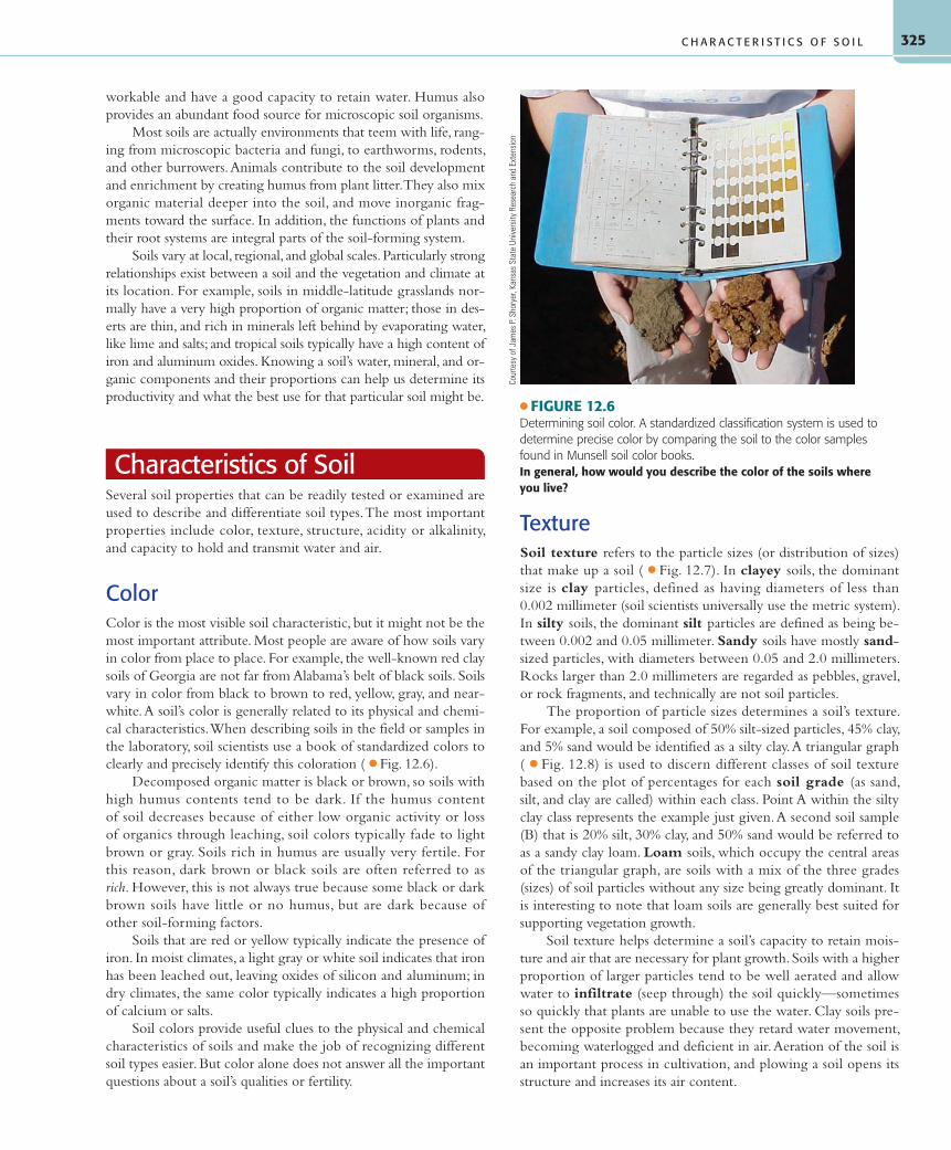
ColorColor is the most visible soil characteristic, but it might not be the most important attribute. Most people are aware of how soils vary in color from place to place. For example, the well-known red clay soils of Georgia are not far from Alabama’s belt of black soils. Soils vary in color from black to brown to red, yellow, gray, and near-white. A soil’s color is generally related to its physical and chemi-cal characteristics. When describing soils in the field or samples in the laboratory, soil scientists use a book of standardized colors to clearly and precisely identify this coloration ( ● Fig. 12.6).
Decomposed organic matter is black or brown, so soils with high humus contents tend to be dark. If the humus content of soil decreases because of either low organic activity or loss of organics through leaching, soil colors typically fade to light brown or gray. Soils rich in humus are usually very fertile. For this reason, dark brown or black soils are often referred to as rich. However, this is not always true because some black or dark brown soils have little or no humus, but are dark because of other soil-forming factors.
Soils that are red or yellow typically indicate the presence of iron. In moist climates, a light gray or white soil indicates that iron has been leached out, leaving oxides of silicon and aluminum; in dry climates, the same color typically indicates a high proportion of calcium or salts.
Soil colors provide useful clues to the physical and chemical characteristics of soils and make the job of recognizing different soil types easier. But color alone does not answer all the important questions about a soil’s qualities or fertility.
TextureSoil texture refers to the particle sizes (or distribution of sizes) that make up a soil ( ● Fig. 12.7). In clayey soils, the dominant size is clay particles, defined as having diameters of less than 0.002 millimeter (soil scientists universally use the metric system). In silty soils, the dominant silt particles are defined as being be-tween 0.002 and 0.05 millimeter. Sandy soils have mostly sand-sized particles, with diameters between 0.05 and 2.0 millimeters. Rocks larger than 2.0 millimeters are regarded as pebbles, gravel, or rock fragments, and technically are not soil particles.
The proportion of particle sizes determines a soil’s texture. For example, a soil composed of 50% silt-sized particles, 45% clay, and 5% sand would be identified as a silty clay. A triangular graph ( ● Fig. 12.8) is used to discern different classes of soil texture based on the plot of percentages for each soil grade (as sand, silt, and clay are called) within each class. Point A within the silty clay class represents the example just given. A second soil sample (B) that is 20% silt, 30% clay, and 50% sand would be referred to as a sandy clay loam. Loam soils, which occupy the central areas of the triangular graph, are soils with a mix of the three grades (sizes) of soil particles without any size being greatly dominant. It is interesting to note that loam soils are generally best suited for supporting vegetation growth.
Soil texture helps determine a soil’s capacity to retain mois-ture and air that are necessary for plant growth. Soils with a higher proportion of larger particles tend to be well aerated and allow water to infiltrate (seep through) the soil quickly—sometimes so quickly that plants are unable to use the water. Clay soils pre-sent the opposite problem because they retard water movement, becoming waterlogged and deficient in air. Aeration of the soil is an important process in cultivation, and plowing a soil opens its structure and increases its air content.
C H A R A C T E R I S T I C S O F S O I L
● FIGURE 12.6Determining soil color. A standardized classification system is used to determine precise color by comparing the soil to the color samples found in Munsell soil color books.In general, how would you describe the color of the soils where you live?
Cour
tesy
of J
ames
P. S
hory
er, K
ansa
s St
ate
Univ
ersi
ty R
esea
rch
and
Exte
nsio
n
55061_12_Ch12_p320_347 pp2.indd 32555061_12_Ch12_p320_347 pp2.indd 325 6/5/08 4:28:50 PM6/5/08 4:28:50 PM
C H A P T E R 1 2 • S O I L S A N D S O I L D E V E L O P M E N T326
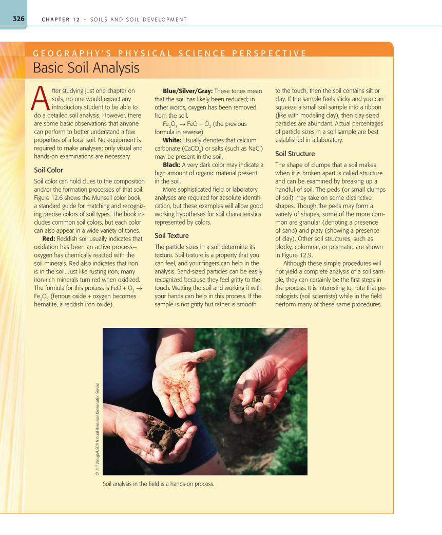
fter studying just one chapter on soils, no one would expect any introductory student to be able to do a detailed soil analysis. However, there are some basic observations that anyone can perform to better understand a few properties of a local soil. No equipment is required to make analyses; only visual and hands-on examinations are necessary.
Soil Color
Soil color can hold clues to the composition and/or the formation processes of that soil. Figure 12.6 shows the Munsell color book, a standard guide for matching and recogniz-ing precise colors of soil types. The book in-cludes common soil colors, but each color can also appear in a wide variety of tones.
Red: Reddish soil usually indicates that oxidation has been an active process—oxygen has chemically reacted with the soil minerals. Red also indicates that iron is in the soil. Just like rusting iron, many iron-rich minerals turn red when oxidized. The formula for this process is FeO + O2 → Fe2O3 (ferrous oxide + oxygen becomes hematite, a reddish iron oxide).
Blue/Silver/Gray: These tones mean that the soil has likely been reduced; in other words, oxygen has been removed from the soil.
Fe2O3 → FeO + O2 (the previous formula in reverse)
White: Usually denotes that calcium carbonate (CaCO3) or salts (such as NaCl) may be present in the soil.
Black: A very dark color may indicate a high amount of organic material present in the soil.
More sophisticated field or laboratory analyses are required for absolute identifi-cation, but these examples will allow good working hypotheses for soil characteristics represented by colors.
Soil Texture
The particle sizes in a soil determine its texture. Soil texture is a property that you can feel, and your fingers can help in the analysis. Sand-sized particles can be easily recognized because they feel gritty to the touch. Wetting the soil and working it with your hands can help in this process. If the sample is not gritty but rather is smooth
to the touch, then the soil contains silt or clay. If the sample feels sticky and you can squeeze a small soil sample into a ribbon (like with modeling clay), then clay-sized particles are abundant. Actual percentages of particle sizes in a soil sample are best established in a laboratory.
Soil Structure
The shape of clumps that a soil makes when it is broken apart is called structure and can be examined by breaking up a handful of soil. The peds (or small clumps of soil) may take on some distinctive shapes. Though the peds may form a variety of shapes, some of the more com-mon are granular (denoting a presence of sand) and platy (showing a presence of clay). Other soil structures, such as blocky, columnar, or prismatic, are shown in Figure 12.9.
Although these simple procedures will not yield a complete analysis of a soil sam-ple, they can certainly be the first steps in the process. It is interesting to note that pe-dologists (soil scientists) while in the field perform many of these same procedures.
G E O G R A P H Y ’ S P H Y S I C A L S C I E N C E P E R S P E C T I V E
Basic Soil Analysis
A
Soil analysis in the field is a hands-on process.
© J
eff V
anug
a/US
DA N
atur
al R
esou
rces
Con
serv
atio
n Se
rvic
e
55061_12_Ch12_p320_347 pp2.indd 32655061_12_Ch12_p320_347 pp2.indd 326 6/5/08 4:28:51 PM6/5/08 4:28:51 PM

327
of clumps. Excess sodium and magnesium have the opposite ef-fect, causing clay soils to become a sticky muck when wet and like concrete when dry. The absence of smaller particles typically hinders the development of a well-defined soil structure.
Scientists classify soil structures according to their form. These range from columns, prisms, and angular blocks, to nutlike spheroids, laminated plates, crumbs, and granules ( ● Fig. 12.9). Soils with mas-sive and fine structures tend to be less useful than aggregates of inter-mediate size and stability, which permit good drainage and aeration.
Acidity and AlkalinityAn important aspect of soil chemistry is a soil’s departure from neutrality toward either acidity or alkalinity (baseness). Levels of acidity or alkalinity are measured on the pH scale of 0 to 14. A pH reading indicates the concentration of reactive hydrogen ions present. The pH scale is logarithmic, meaning that each change in a whole pH number represents a tenfold change. It is also an inverted scale—a lower pH means a greater amount of hydrogen ions pres-ent (higher acidity). Low pH values indicate an acid soil, and high pH indicates alkaline conditions ( ● Fig. 12.10).
StructureIn most soils, particles clump into distinctive masses known as soil peds, which give a soil a distinctive structure. Soil structure influences a soil’s porosity—the amount of space that may contain fluids. Soil structure also influ-ences permeability—the rate at which fluids such as water can pass through. Permeability is usually greatest in sandy soils, and poros-ity is usually greatest in clayey soils. Both of these factors control soil drainage as well as the available moisture in a soil. Soils with sim-ilar textures may have different structures, and vice versa.
Soil structure can be influenced by out-side factors such as moisture regime and the nutrient cycles that plants use to interchange chemicals with the soil, keeping certain ones in the system while others are leached away. We have all seen the structural change in soils that occurs when soils are wet compared to when they are dry. Human activities also influence soil structure through cultivation, irrigation, and fertilization. Fertilizers, as well as lime or decayed organic debris, encourage clumping of soil particles and the maintenance
C H A R A C T E R I S T I C S O F S O I L
0 1 2
Sand
Comparative sizes ofsoil/rock particles
Silt
0.05 – 2.0 mm
0.002 – 0.05 mm
Greatlyenlarged
Actual size of sand grain 1 mm diameter
0
mm
Inches1/16
Clay
Invisible atthis scale
● FIGURE 12.7Particle sizes in soil. Sand, silt, and clay are terms that refer to the size of these particles for scientific and engineering purposes. Here, the sizes of each can be compared. Clay particles are tiny, sheetlike particles that cannot be seen.
Percent sand
100
0102030405060708090100
100
90
80
70
60
50
40
30
20
10
0
90
80
70
60
50
40
30
20
10
0
Percent silt
Perc
ent c
lay
Clay
Clay loam
Loam
Loamysand
Sandyclay
Siltyclay
Sandy clay loam
Silty clayloam
Sandy loam Silty loam
Sand Silt
B
A
● FIGURE 12.8The texture of a soil can be represented by a plotting a point on this diagram. Texture is determined by sieving the soil to determine the percentage of particles falling into the size ranges for clay, silt, and sand. Note that each of the three axes of the triangle is in a differ-ent color and the line colors also correspond (clay-red, silt-blue, sand-green).What would a soil that contains 40% sand, 40% silt, and 20% clay be classified as?
55061_12_Ch12_p320_347 pp2.indd 32755061_12_Ch12_p320_347 pp2.indd 327 6/5/08 4:28:53 PM6/5/08 4:28:53 PM

C H A P T E R 1 2 • S O I L S A N D S O I L D E V E L O P M E N T328
Soil acidity or alkalinity helps determine the available nutrients that affect plant growth. Plants absorb nutrients that are dissolved in liquid. However, soil water that lacks some degree of acidity has little ability to dissolve these nutrients. As a result, even though nu-trients are in the soil, plants may not have access to them.
Most complex plants will grow only in soils with levels between pH 4 and pH 10, although the optimum pH for veg-etation growth varies with the plant species. Around the world, vegetation has evolved in and adapted to a variety of climates and soil environments, both of which can affect soil pH. Cer-tain species tolerate alkaline soils, and others thrive under more acid conditions.
Leaching caused by high rainfall gradually replaces soil elements such as sodium (Na), potassium (K), magnesium (Mg), and calcium (Ca) with hydrogen. Falling rain picks up atmospheric carbon dioxide and becomes slightly acidic: H
2O + CO
2 = H
2CO
3
(carbonic acid), so desert soils tend to be alkaline and soils in humid regions tend to be acidic ( ● Fig. 12.11). The humus content in the soils of humid areas also contributes to higher soil acidity.
To correct soil alkalinity, common in the arid regions, and to make the soil more productive, the soil can be flushed with irrigation water. Strongly acidic soils are also detrimental to plant growth. In acidic soils, soil moisture dissolves nutrients, but they may be leached away before plant roots can absorb them. Soil acid-ity can generally be corrected by adding lime to the soil. In addi-tion to affecting plant growth, soil acidity or alkalinity also affects microorganisms in the soil. Microorganisms are highly sensitive to a soil’s pH, and each species has an optimum environmental setting.
Development of Soil HorizonsSoil development begins when plants and animals colonize rocks or deposits of rock fragments, the parent material on which soil will form. Once organic processes begin among mineral particles or rock fragments, differences begin to develop from the surface down through the parent material.
Initially, vertical differences result from the surface accumu-lation of organic litter and the removal of fine particles and dis-solved minerals from upper layers by percolating water that deposits these materials at a lower level. The vertical cross sec-tion of a soil from the surface down to the parent material is called a soil profile ( ● Fig. 12.12). Examining soil profiles and the vertical differences they contain is important to recognizing different soil types and how those soils developed. As climate, vegetation, animal life, and characteristics of the land surface affect soil formation over time, this vertical differentiation be-comes more and more apparent.
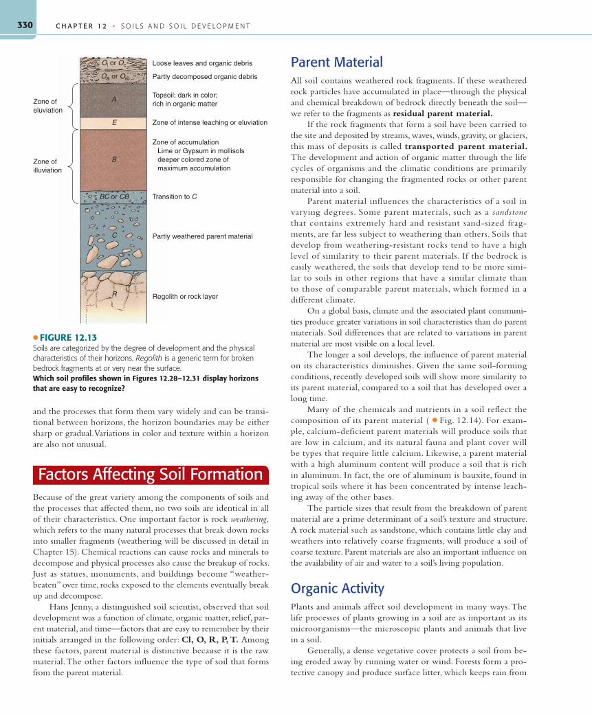
Soil HorizonsWithin their soil profiles, well-developed soils typically exhibit several distinct layers, called soil horizons, that are distinguished by their physical and chemical properties. Soils are classified largely on the differences in their horizons and in the processes respon-sible for those differences ( ● Fig. 12.13). Soil horizons are desig-nated by a set of letters that refer to their composition, dominant
process, and/or position in the soil profile.At the surface, but only in locations where
there is a sufficient cover of decomposed veg-etation litter, there will be an O horizon. This is a layer of organic debris and humus; the “O” designation refers to this horizon’s high organic content. Immediately below is theA horizon, commonly referred to as “topsoil.” In general, the A horizon is dark because it con-tains decomposed organic matter. Beneath the A horizon, certain soils have a lighter-colored E horizon, named for the action of strong elu-vial processes. Below this is a zone of accu-mulation, the B horizon, where much of the materials removed from the A and E horizons are deposited. Except in soils with a high or-ganic content that has been mixed vertically, the B horizon generally has little humus. The C horizon is the weathered parent material from which the soil has developed—either fragments of the bedrock, or deposits of rock materials that were transported to the site by water, wind, glacial, or other surface process.
The lowest layer, sometimes called the R horizon, is unchanged parent material, either bedrock or transported deposits of rock frag-ments. Certain horizons in some soils may not be as well developed as others, and some ho-rizons may be missing altogether. Because soils
Platelike
Platy Lenticular
Prismlike
Prismatic Columnar
Blocklike
Spheroidal
Blocky Nuciform Granular Crumb
● FIGURE 12.9This guide to classifying the structure of a soil on the basis of soil peds can be used to help determine other characteristics of a soil.How does soil structure affect a soil’s usefulness or suitability for agriculture?
55061_12_Ch12_p320_347 pp2.indd 32855061_12_Ch12_p320_347 pp2.indd 328 6/10/08 2:57:09 PM6/10/08 2:57:09 PM

329D E V E L O P M E N T O F S O I L H O R I Z O N S
Incr
easi
ngly
aci
dic
Incr
easi
ngly
bas
ic o
r al
kalin
e
Neutralsolution
0
pH Solution
Battery acid
Normal stomach acidity (1.0 to 3.0)Lemon juice (2.3), acid fog (2 to 3.5)
Vinegar, wine, soft drinks, beer
Orange juice
Tomatoes, grapes, acid deposition (4 to 5)
Black coffee, most shaving lotions
BreadNormal rainwater (5.6)
Milk (6.6)Saliva (6.2 to 7.4)Pure water
Blood (7.3 to 7.5), swimming pool waterEggsSeawater (7.8 to 8.3)Shampoo
Baking sodaPhosphate detergentsChlorine bleach, antacids
Milk of magnesia (9.9 to 10.1)Soap solutions
Household ammonia (10.5 to 11.9)Nonphosphate detergents
Washing soda (Na2CO3)
Hair remover
Oven cleaner
1
2
3
4
5
6
7
8
9
10
11
12
13
14
(a)
● FIGURE 12.10(a) The pH scale of acidity, neutrality, and alkalinity. The degree of acidity or of alkalinity, called pH, can be easily understood when numbers on the scale are linked to common substances. Low pH means acidic, and high pH means alkaline; a reading of 7 is neutral. (b) Alkalinity in a soil can be tested in the field with drops of a dilute acid. If the soil fizzes in the acid solution, alkalinity is typically high.
USDA
/NRC
S/Ti
m M
cCab
e
(b)
Alkalinesoils
Acidicsoils
30 inches ofrain per year
● FIGURE 12.11The distribution of alkaline and acidic soils in the United States is gen-erally related to climate. Soils in the East tend to be acidic and those in the West, alkaline. The dividing line corresponds fairly well with the 30-inch annual precipitation isohyet.Other than climate, what environmental factors might cause this east–west variation, and why are some places west of the 30-inch line acidic?
● FIGURE 12.12A soil profile is examined by digging a pit with vertical walls to clearly show variations in color, structure, composition, and other characteristics that occur with depth. This soil is in a grassland region of northern Minnesota.
© H
ari E
swar
an, U
SDA/
NRC
S
55061_12_Ch12_p320_347 pp2.indd 32955061_12_Ch12_p320_347 pp2.indd 329 6/5/08 4:28:54 PM6/5/08 4:28:54 PM
C H A P T E R 1 2 • S O I L S A N D S O I L D E V E L O P M E N T330
and the processes that form them vary widely and can be transi-tional between horizons, the horizon boundaries may be either sharp or gradual. Variations in color and texture within a horizon are also not unusual.
Factors Affecting Soil FormationBecause of the great variety among the components of soils and the processes that affected them, no two soils are identical in all of their characteristics. One important factor is rock weathering, which refers to the many natural processes that break down rocks into smaller fragments (weathering will be discussed in detail in Chapter 15). Chemical reactions can cause rocks and minerals to decompose and physical processes also cause the breakup of rocks. Just as statues, monuments, and buildings become “weather-beaten” over time, rocks exposed to the elements eventually break up and decompose.
Hans Jenny, a distinguished soil scientist, observed that soil development was a function of climate, organic matter, relief, par-ent material, and time—factors that are easy to remember by their initials arranged in the following order: Cl, O, R, P, T. Among these factors, parent material is distinctive because it is the raw material. The other factors influence the type of soil that forms from the parent material.
Parent MaterialAll soil contains weathered rock fragments. If these weathered rock particles have accumulated in place—through the physical and chemical breakdown of bedrock directly beneath the soil—we refer to the fragments as residual parent material.
If the rock fragments that form a soil have been carried to the site and deposited by streams, waves, winds, gravity, or glaciers, this mass of deposits is called transported parent material. The development and action of organic matter through the life cycles of organisms and the climatic conditions are primarily responsible for changing the fragmented rocks or other parent material into a soil.
Parent material influences the characteristics of a soil in varying degrees. Some parent materials, such as a sandstone that contains extremely hard and resistant sand-sized frag-ments, are far less subject to weathering than others. Soils that develop from weathering-resistant rocks tend to have a high level of similarity to their parent materials. If the bedrock is easily weathered, the soils that develop tend to be more simi-lar to soils in other regions that have a similar climate than to those of comparable parent materials, which formed in a different climate.
On a global basis, climate and the associated plant communi-ties produce greater variations in soil characteristics than do parent materials. Soil differences that are related to variations in parent material are most visible on a local level.
The longer a soil develops, the influence of parent material on its characteristics diminishes. Given the same soil-forming conditions, recently developed soils will show more similarity to its parent material, compared to a soil that has developed over a long time.
Many of the chemicals and nutrients in a soil reflect the composition of its parent material ( ● Fig. 12.14). For exam-ple, calcium-deficient parent materials will produce soils that are low in calcium, and its natural fauna and plant cover will be types that require little calcium. Likewise, a parent material with a high aluminum content will produce a soil that is rich in aluminum. In fact, the ore of aluminum is bauxite, found in tropical soils where it has been concentrated by intense leach-ing away of the other bases.
The particle sizes that result from the breakdown of parent material are a prime determinant of a soil’s texture and structure. A rock material such as sandstone, which contains little clay and weathers into relatively coarse fragments, will produce a soil of coarse texture. Parent materials are also an important influence on the availability of air and water to a soil’s living population.
Organic ActivityPlants and animals affect soil development in many ways. The life processes of plants growing in a soil are as important as its microorganisms—the microscopic plants and animals that live in a soil.
Generally, a dense vegetative cover protects a soil from be-ing eroded away by running water or wind. Forests form a pro-tective canopy and produce surface litter, which keeps rain from
Loose leaves and organic debris
Partly decomposed organic debris
Topsoil; dark in color;rich in organic matter
Zone of intense leaching or eluviation
Lime or Gypsum in mollisolsdeeper colored zone ofmaximum accumulation
Zone of accumulation
Transition to C
Partly weathered parent material
Regolith or rock layer
Zone ofeluviation
Zone ofilluviation
Oa or Oe
Oi or Oc
A
E
BC or CB
C
R
B
● FIGURE 12.13Soils are categorized by the degree of development and the physical characteristics of their horizons. Regolith is a generic term for broken bedrock fragments at or very near the surface.Which soil profiles shown in Figures 12.28–12.31 display horizons that are easy to recognize?
55061_12_Ch12_p320_347 pp2.indd 33055061_12_Ch12_p320_347 pp2.indd 330 6/5/08 4:28:58 PM6/5/08 4:28:58 PM

331
beating directly on the soil and increases the proportion of rain-water entering the soil rather than running off its surface. Varia-tions in vegetation species and density of cover can also affect the evapotranspiration rates. A sparse vegetative cover will allow greater evaporation of soil moisture and dense vegetation tends to maintain soil moisture.
The characteristics of a plant community affect the nutrient cycles that are involved in soil development ( ● Fig. 12.15). As plants die and decompose, or leaves fall to the ground, nutrients are returned to the soil. Soils, however, can become impoverished if soluble nutrients that are not used by plants are lost through leaching. The roots of plants help to break up the soil structure, making it more porous, and roots also absorb water and nutrients from the soil.
Leaves, bark, branches, flowers, and root networks con-tribute to the organic composition of soil, through litter and through the remains of dead plants. The organic content of soil depends on its associated plant life. For example, a grass-covered prairie supplies much more organic matter than the thin vegeta-tive cover of desert regions. There is some question, however,
as to whether forests or grasslands (with their thick root net-works and annual life cycle) furnish the soil with greater organic content. Many of the world’s grassland regions, like the North American prairies, provide some of the world’s most fertile soils for cultivation in part because of the high amount of organic matter that a grass cover generates.
In terms of their contribution to soil formation, bacteria are perhaps the most important microorganisms that live in soils. Bac-teria break down organic matter, humus, and the debris of living things into organic and inorganic components, allowing the for-mation of new organic compounds that promote plant growth. It has been suggested that the number of bacteria, fungi, and other microscopic plants and animals living in a soil may be 1 billion per gram (a fifth of a teaspoon) of soil. The activities and remains of these microorganisms, minute though they are individually, add considerably to the organic content of a soil.
Earthworms, nematodes, ants, termites, wood lice, centi-pedes, burrowing rodents, snails, and slugs also stir up the soil, mixing mineral components from lower levels with organic components from the upper portion. Earthworms contribute greatly to soil development because they take soil in, pass it through their digestive tracts, and excrete it in casts. The pro-cess not only helps mix the soil but also changes the texture, structure, and chemical qualities of the soil. In the late 1800s, Charles Darwin estimated that earthworm casts produced in a year would equal as much as 10–15 tons per acre. As for the number of earthworms, a study suggested that the total weight of earthworms beneath a pasture in New Zealand equaled the weight of the sheep grazing above them.
ClimateChapters 9 and 10 demonstrated that, on a world regional scale, climate is a major factor in soil formation. Of course, if the cli-mate is the same in a region where the soils vary, other factors must be responsible for the local variation. Soil differences that are apparent at a local level tend to reflect the influence of factors such as parent materials, land surface configurations, vegetation types, and time.
Temperature directly affects soil microorganism activity, which in turn affects the decomposition rates of organic matter. In hot equatorial regions, intense activities by soil microorgan-isms preclude thick accumulations of organic debris or humus. ● Figure 12.16 shows that the amounts of organic matter and humus in a soil increase toward the middle latitudes and away from polar regions and the tropics. In the mesothermal and mi-crothermal climates (C and D), microorganism activity is slow enough to allow decaying organic matter and humus to accumu-late in rich layers. Moving poleward into colder regions, retarded microorganism activity and limited plant growth tends to result in thin accumulations of organic matter.
Chemical activity increases and decreases directly with tem-perature, given equal availability of moisture. As a result, parent materials of soils in hot, humid equatorial regions are altered to a far greater degree by chemical means than are parent materials in colder zones.
● FIGURE 12.14Despite strong leaching under a wet tropical climate, Hawaiian soils remain high in nutrients because their parent material is of recent volcanic origin.What other parent materials provide the basis for continuously fertile soils in wet tropical climates?
R. G
able
r
FA C TO R S A F F E C T I N G S O I L F O R M AT I O N
55061_12_Ch12_p320_347 pp2.indd 33155061_12_Ch12_p320_347 pp2.indd 331 6/5/08 4:28:59 PM6/5/08 4:28:59 PM

C H A P T E R 1 2 • S O I L S A N D S O I L D E V E L O P M E N T332
Temperature affects soil indirectly through its influence on veg-etation associations that are adapted to certain climatic regimes. Soils generally reflect the character of plant cover because of nutrient cycles that tend to keep both vegetation and soil in chemical equi-
librium. The combined effects of vegetative cover and the climatic regime tend to produce soil profiles and characteristics that tend to share certain characteristics among different regions that have similar climates and vegetation associations ( ● Fig. 12.17).
Moisture conditions affect the development and character of soils more directly than any other climatic factor. Without precipitation, and the soil water it provides, terrestrial plant life would be im-possible. Ample precipitation supports plant growth that can greatly increase the organic content and thereby the fertility of a soil. However, extremely high rainfall will cause leaching of nutrients, and a relatively infertile soil.
Gravitational and capillary water have pro-nounced effects on soil development, structure, texture, and color. Precipitation is the original source of soil water (disregarding the minor con-tribution of dew), and the amount of precipitation received affects leaching, eluviation, and illuvia-tion and thereby rates of soil formation and ho-rizon development. The evaporation rate is a very important factor as well. Salt and gypsum deposits from the upward migration of capillary water are more extensive in hot, dry regions—such as the southwestern United States where evaporation rates are high—than in colder, dry regions (see again Fig. 12.17).
Land Surface ConfigurationThe slope of the land, its relief, and its aspect (the direction it faces) all influence soil development. Steep slopes are generally better drained than gen-tler ones, and they are also subject to rapid runoff of surface water. As a consequence, there is less in-
filtration of water on steeper slopes, which inhibits soil development, sometimes to the extent that there will be no soil. In addition, rapid runoff on steep slopes can erode sur-faces as fast or faster than soil can develop on them. On gentler slopes, where there is less runoff and higher infiltration, more water is available for soil development and to support vegetation growth, so erosion is not as in-tense. In fact, erosion rates in areas of gently rolling hills may be just enough to offset the development of soils. Well-developed soils typically form on land that is flat or has a gentle slope.
Slope aspect has a direct effect on micro-climates in areas outside of the equatorial tropics. North-facing slopes in the middle and high latitudes of the Northern Hemisphere have microclimates that are cooler and wetter than those on south-facing exposures, which receive the sun’s rays at a steeper angle and are therefore warmer and drier. Local variations
Rate of destructionby aerobic bacteria
Rate of production(macroflora)
Destruction byanaerobic bacteria
Humusabsent
20 40 60 80 100
Mean annual temperature (°F)
Middle LatitudesPolar Tropics
0
2
4
6
8
Org
anic
mat
ter
prod
uced
or
dest
roye
d
Humus accumulates
● FIGURE 12.16The relationship of temperature to production and destruction of organic matter in the soil.What range of mean annual temperatures is most favorable for the accumulation of humus?
Forest canopy
Rain of deadforest detritus
Treetrunks
Forest litter
Root and decay zone
Input fromrock weathering
Output into groundwater and stream flow
● FIGURE 12.15The nutrient cycle in a forest. Trees take up nutrients from the soil through soil water absorbed into their root systems. Nutrients are supplied by the breakdown of rocks and minerals, as well as by leaf and other organic litter.
55061_12_Ch12_p320_347 pp2.indd 33255061_12_Ch12_p320_347 pp2.indd 332 6/5/08 4:29:00 PM6/5/08 4:29:00 PM

333
Mosaicof closelypackedpebbles,boulders
Weak humus–mineral mixture
reddish-brownwith variableaccumulationsof clay, calciumcarbonate, andsoluble salts
Desert Soil(hot, dry climate)
Alkaline,dark,and richin humus
Clay,calciumcompounds
Grassland Soil(semiarid climate)
Acidiclight-coloredhumus
Iron andaluminumcompoundsmixed withclay
Tropical Rain Forest Soil(humid, tropical climate)
Deciduous Forest Soil(humid, mild climate)
Forest litterleaf mold
Humus–mineralmixture
Light, grayish-brown, silt loam
Dark brownfirm clay
Acid litterand humus
and acidic
Humus andiron andaluminumcompounds
Coniferous Forest Soil(humid, cold climate)
Dry, brown to
Light-colored
● FIGURE 12.17Idealized diagrams of five different soil profiles illustrate the effects of climate and vegetation on the develop-ment of soils and their horizons.Which two environments produce the most humus and which two produce the least?
in soil depth, texture, and profile development result directly from microclimate differences.
Topography, through its effects on vegetation, indirectly in-fluences soil development. Steep slopes prevent the formation of a soil that would support abundant vegetation, and a modest plant cover yields less organic debris for the soil.
TimeSoils have a tendency to develop toward a state of equilibrium with their environment. A soil is sometimes called “mature” when it has reached such a condition of equilibrium. Young soils are still in the process of developing toward being in equilibrium with
FA C TO R S A F F E C T I N G S O I L F O R M AT I O N
55061_12_Ch12_p320_347 pp2.indd 33355061_12_Ch12_p320_347 pp2.indd 333 6/5/08 4:29:01 PM6/5/08 4:29:01 PM
C H A P T E R 1 2 • S O I L S A N D S O I L D E V E L O P M E N T334
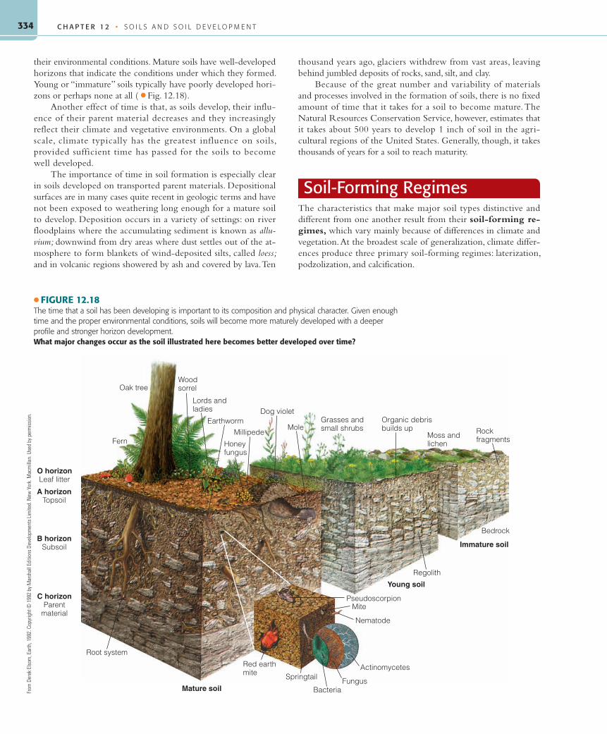
their environmental conditions. Mature soils have well-developed horizons that indicate the conditions under which they formed. Young or “immature” soils typically have poorly developed hori-zons or perhaps none at all ( ● Fig. 12.18).
Another effect of time is that, as soils develop, their influ-ence of their parent material decreases and they increasingly reflect their climate and vegetative environments. On a global scale, climate typically has the greatest influence on soils, provided sufficient time has passed for the soils to become well developed.
The importance of time in soil formation is especially clear in soils developed on transported parent materials. Depositional surfaces are in many cases quite recent in geologic terms and have not been exposed to weathering long enough for a mature soil to develop. Deposition occurs in a variety of settings: on river floodplains where the accumulating sediment is known as allu-vium; downwind from dry areas where dust settles out of the at-mosphere to form blankets of wind-deposited silts, called loess; and in volcanic regions showered by ash and covered by lava. Ten
thousand years ago, glaciers withdrew from vast areas, leaving behind jumbled deposits of rocks, sand, silt, and clay.
Because of the great number and variability of materials and processes involved in the formation of soils, there is no fixed amount of time that it takes for a soil to become mature. The Natural Resources Conservation Service, however, estimates that it takes about 500 years to develop 1 inch of soil in the agri-cultural regions of the United States. Generally, though, it takes thousands of years for a soil to reach maturity.
Soil-Forming RegimesThe characteristics that make major soil types distinctive and different from one another result from their soil-forming re-gimes, which vary mainly because of differences in climate and vegetation. At the broadest scale of generalization, climate differ-ences produce three primary soil-forming regimes: laterization, podzolization, and calcification.
Immature soil
Bedrock
Young soil
Regolith
RockfragmentsMoss and
lichen
Organic debrisbuilds up
Grasses andsmall shrubs
EarthwormMole
Millipede
Dog violetLords andladies
Honeyfungus
Oak tree
Fern
Mature soil
Root system
Pseudoscorpion
Red earthmite Springtail
Bacteria
O horizonLeaf litter
Woodsorrel
A horizonTopsoil
B horizonSubsoil
C horizonParent
materialMite
Nematode
Actinomycetes
Fungus
● FIGURE 12.18The time that a soil has been developing is important to its composition and physical character. Given enough time and the proper environmental conditions, soils will become more maturely developed with a deeper profile and stronger horizon development.What major changes occur as the soil illustrated here becomes better developed over time?
From
Der
ek E
lsom
, Ear
th, 1
992.
Cop
yrig
ht ©
199
2 by
Mar
shal
l Edi
tions
Dev
elop
men
ts L
imite
d. N
ew Y
ork.
Mac
mill
an. U
sed
by p
erm
issi
on.
55061_12_Ch12_p320_347 pp2.indd 33455061_12_Ch12_p320_347 pp2.indd 334 6/5/08 4:29:02 PM6/5/08 4:29:02 PM

335
LaterizationLaterization is a soil-forming regime that occurs in humid tropical and subtropical climates as a result of high temperatures and abundant precipitation. These climatic environments encour-age rapid breakdown of rocks and decomposition of nearly all minerals. A soil of this type is known as laterite, and these soils are generally reddish in color from iron oxides; the term laterite means “brick-like.” In tropical areas laterite is quarried for build-ing material ( ● Fig. 12.19).
Despite the dense vegetation that is typical of these climate regions, little humus is incorporated into the soil because the plant litter decomposes so rapidly. Laterites do not have an O horizon, and the A horizon loses fine soil particles as well as most minerals and bases except for iron and aluminum com-pounds, which are insoluble primarily because of the absence of organic acids ( ● Fig. 12.20). As a result, the topsoil is reddish, coarse textured, and tends to be porous. In contrast to the A ho-rizon, the B horizon in a lateritic soil has a heavy concentration of illuviated materials.
In the tropical forests, soluble nutrients released by weather-ing are quickly absorbed by vegetation, which eventually returns them to the soil where they are reabsorbed by plants. This rapid cycling of nutrients prevents the total leaching away of bases, leav-ing the soil only moderately acidic. Removal of vegetation per-mits total leaching of bases, resulting in the formation of crusts of iron and aluminum compounds (laterites), as well as accelerated erosion of the A horizon.
Laterization is a year-round process because of the small seasonal variations in temperature or soil moisture in the humid tropics. This continuous activity and strong weathering of parent material cause some tropical soils to develop to depths of as much as 8 meters (25 ft) or more.
PodzolizationPodzolization occurs mainly in the high middle latitudes where the climate is moist with short, cool summers and long, severe win-ters. The coniferous forests of these climate regions are an integral part of the podzolization process.
Where temperatures are low much of the year, microorgan-ism activity is reduced enough that humus does accumulate; how-ever, because of the small number of animals living in the soil, there is little mixing of humus below the surface. Leaching and eluviation by acidic solutions remove the soluble bases and alu-minum and iron compounds from the A horizon ( ● Fig. 12.21). The remaining silica gives a distinctive ash-gray color to the
E horizon (podzol is derived from a Russian word mean-ing “ashy”). The needles that coniferous trees drop are chemically acidic and contribute to the soil acidity. It is difficult to determine whether the soil is acidic because of the vegetative cover or whether the vegetative cover is adapted to the acidic soil.
Podzolization can take place outside the typical cold, moist climate regions if the parent material is highly acidic—for example, on the sandy areas common along the East Coast of the United States. The pine forests that grow in such acidic conditions return acids to the soil, promoting the process of podzolization.
CalcificationA third distinctive soil-forming regime is called calcification. In contrast to both laterization and pod-zolization, which require humid climates, calcification occurs in regions where evapotranspiration significantly exceeds precipitation. Calcification is important in the climate regions where moisture penetration is shallow. The subsoil is typically too dry to support tree growth,
Little or no organicdebris, little silica,much residual ironand aluminum,coarse texture
Some illuvial bases,much accumulatedlaterite
Much of the solublematerial lost todrainage
C
A
B
● FIGURE 12.20Soil profile horizons in laterite, one of three major soil-forming regimes. Lat-erization is a soil development process that occurs in tropical and equatorial zones that experience warm temperatures year round and wet climates.
● FIGURE 12.19Laterite cut for building stone and stacked along a village road in the state of Orissa, India.Why is building with brick or stone rather than wood so important in heavily populated, less developed nations such as India?
R. G
able
r
S O I L - F O R M I N G R E G I M E S
55061_12_Ch12_p320_347 pp2.indd 33555061_12_Ch12_p320_347 pp2.indd 335 6/5/08 4:29:03 PM6/5/08 4:29:03 PM

C H A P T E R 1 2 • S O I L S A N D S O I L D E V E L O P M E N T336
and shallow-rooted grass or shrubs are the primary forms of vegetation. Calcification is enhanced as grasses use calcium, drawing it up from lower soil layers and returning it to the soil when the annual grasses die. Grasses and their dense root net-works provide large amounts of organic matter, which is mixed deep into the soil by burrowing animals. Middle-latitude grass-land soils are rich in bases and in humus and are the world’s most productive agricultural soils. The deserts of the American West generally have no humus, and the rise of capillary water can leave not only calcium carbonate but also sodium chloride (salt) at the surface.
In many areas of low precipitation, the air is often loaded with alkali dusts such as calcium carbonate (CaCO
3). When
calm conditions prevail or when it rains, the dust settles and accumulates in the soil. The rainfall produces an amount of soil water that is just sufficient to translocate these materials to the B horizon ( ● Fig. 12.22). Over hundreds to thousands of years, the CaCO
3-enriched dust concentrates in the B ho-
rizon, forming hard layers of caliche. Much thicker accumula-tions called calcretes ( ● Fig. 12.23) form by the upward (capillary) movement of dissolved calcium in groundwater when the water table is near the surface.
Regimes of Local ImportanceTwo additional localized soil-forming regimes merit attention. Both characterize areas with poor drainage although they occur under very different climate conditions. The first, salinization, or the concentration of salts in the soil, is often detrimental to
plant growth. Salinization occurs in stream valleys, interior basins, and other low-lying areas, particularly in arid regions with high groundwater tables. The high groundwater levels can be the result of water from adjacent mountain ranges, stream flow originating in humid regions, or a wet–dry seasonal precipitation regime ( ● Fig. 12.24). Salinization can also be a consequence of inten-sive irrigation under arid conditions. Rapid evaporation leaves
Thin, dark
Darker than E;often colorful;accumulations ofhumus; Fe, Al, N,Ca, Mg, Na, K
Some Ca, Mg, Na,and K leacheddown from B islost to lateralmovement of waterbelow water table
C
E
A
Oe
Oi
B
Well-developedorganic horizons
Badly leached, lightin color, largely Si
● FIGURE 12.21Soil profile horizons in a podzol soil, another of the three major soil-forming regimes. Podzolization typically occurs under cool, wet climates in regions of coniferous trees or in boggy environments, and is a very acidic soil type.
● FIGURE 12.23This shallow-rooted grass is growing in a thin layer of topsoil over a much thicker layer of calcium carbonate called calcrete.What precipitation characteristics are associated with the calcification soil-forming process?
© S
tate
of V
icto
ria, D
epar
tmen
t of P
rimar
y In
dust
ries,
199
7
Dark color,granular structure,high content ofresidual bases
Lighter color,very high contentof accumulatedbases, calichenodules
Relativelyunaltered,rich in basesupply, virtuallyno loss todrainage water
A
O
C
B
● FIGURE 12.22Soil profile horizons in a calcified soil, formed by the third major soil-forming regime. Calcification is a soil development process that is most prominent in cool to hot subhumid or semiarid climate regions, particu-larly in grassland regions, but also in deserts.
55061_12_Ch12_p320_347 pp2.indd 33655061_12_Ch12_p320_347 pp2.indd 336 6/5/08 4:29:06 PM6/5/08 4:29:06 PM
337S O I L - F O R M I N G R E G I M E S
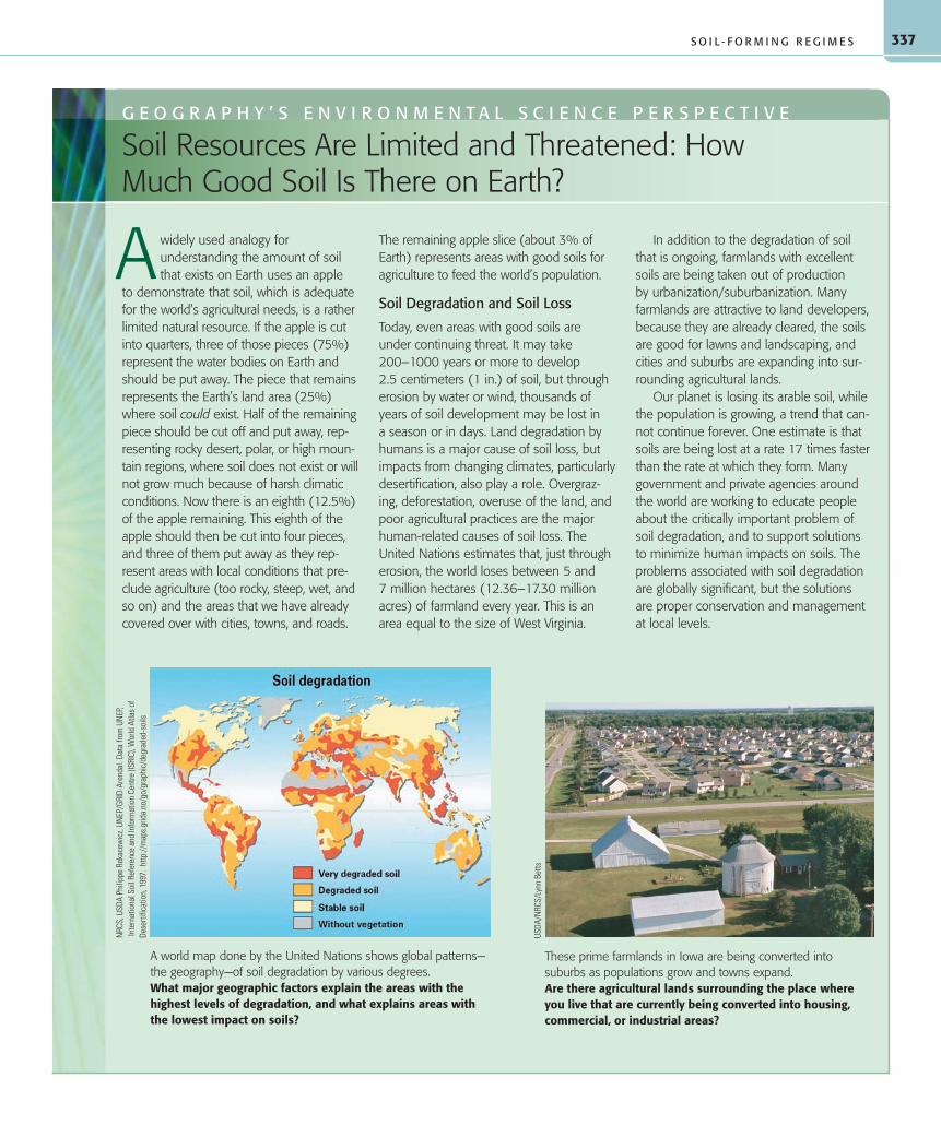
widely used analogy for understanding the amount of soil that exists on Earth uses an apple to demonstrate that soil, which is adequate for the world’s agricultural needs, is a rather limited natural resource. If the apple is cut into quarters, three of those pieces (75%) represent the water bodies on Earth and should be put away. The piece that remains represents the Earth’s land area (25%) where soil could exist. Half of the remaining piece should be cut off and put away, rep-resenting rocky desert, polar, or high moun-tain regions, where soil does not exist or will not grow much because of harsh climatic conditions. Now there is an eighth (12.5%) of the apple remaining. This eighth of the apple should then be cut into four pieces, and three of them put away as they rep-resent areas with local conditions that pre-clude agriculture (too rocky, steep, wet, and so on) and the areas that we have already covered over with cities, towns, and roads.
The remaining apple slice (about 3% of Earth) represents areas with good soils for agriculture to feed the world’s population.
Soil Degradation and Soil Loss
Today, even areas with good soils are under continuing threat. It may take 200–1000 years or more to develop 2.5 centimeters (1 in.) of soil, but through erosion by water or wind, thousands of years of soil development may be lost in a season or in days. Land degradation by humans is a major cause of soil loss, but impacts from changing climates, particularly desertification, also play a role. Overgraz-ing, deforestation, overuse of the land, and poor agricultural practices are the major human-related causes of soil loss. The United Nations estimates that, just through erosion, the world loses between 5 and 7 million hectares (12.36–17.30 million acres) of farmland every year. This is an area equal to the size of West Virginia.
In addition to the degradation of soil that is ongoing, farmlands with excellent soils are being taken out of production by urbanization/suburbanization. Many farmlands are attractive to land developers, because they are already cleared, the soils are good for lawns and landscaping, and cities and suburbs are expanding into sur-rounding agricultural lands.
Our planet is losing its arable soil, while the population is growing, a trend that can-not continue forever. One estimate is that soils are being lost at a rate 17 times faster than the rate at which they form. Many government and private agencies around the world are working to educate people about the critically important problem of soil degradation, and to support solutions to minimize human impacts on soils. The problems associated with soil degradation are globally significant, but the solutions are proper conservation and management at local levels.
G E O G R A P H Y ’ S E N V I R O N M E N T A L S C I E N C E P E R S P E C T I V E
Soil Resources Are Limited and Threatened: How Much Good Soil Is There on Earth?
These prime farmlands in Iowa are being converted into suburbs as populations grow and towns expand.Are there agricultural lands surrounding the place where you live that are currently being converted into housing, commercial, or industrial areas?
A
A world map done by the United Nations shows global patterns—the geography—of soil degradation by various degrees.What major geographic factors explain the areas with the highest levels of degradation, and what explains areas with the lowest impact on soils?
NRC
S, U
SDA
Phili
ppe
Reka
cew
icz,
UNEP
/GRI
D-Ar
enda
l. Da
ta fr
om U
NEP
, In
tern
atio
nal S
oil R
efer
ence
and
Info
rmat
ion
Cent
re (I
SRIC
), W
orld
Atla
s of
De
serti
ficat
ion,
199
7. h
ttp://
map
s.gr
ida.
no/g
o/gr
aphi
c/de
grad
ed-s
oils
USDA
/NRC
S/Ly
nn B
etts
55061_12_Ch12_p320_347 pp2.indd 33755061_12_Ch12_p320_347 pp2.indd 337 6/5/08 4:29:07 PM6/5/08 4:29:07 PM

C H A P T E R 1 2 • S O I L S A N D S O I L D E V E L O P M E N T338
behind a high concentration of soluble salts and may destroy a soil’s agricultural productivity. An extreme example of saliniza-tion exists in certain areas of the Middle East, where thousands of years of irrigated agriculture in the desert have made the soils too saline to cultivate today.
Another localized soil regime, gleization, occurs in poorly drained areas under cold, wet environmental conditions. Gley soils, as they are called, are typically associated with peat bogs where the soil has an accumulation of humus overlying a blue-gray layer of thick, gummy, water-saturated clay. In poorly drained regions that were formerly glaciated, such as northern Russia, Ire-land, Scotland, and Scandinavia, peat has long been harvested and used as a source of energy.
Soil ClassificationSoils, like climates, can be classified by their characteristics and mapped by their spatial distributions. In the United States the Soil Survey Division of the Natural Resources Conservation Service (NRCS), a branch of the Department of Agriculture, is respon-sible for soil classification (termed soil taxonomy). As with any classification system, the methods and categories are continually being updated and refined.
Soil classifications are published in soil surveys, books that outline and describe the kinds of soils in a region and include maps that show the distribution of soil types, usually at the county level. These documents, available for most parts of the United States, are useful references for factors such as soil fertility, irriga-tion, and drainage.
The NRCS Soil Classification SystemThe NRCS soil classification system is based on the development and composition of soil horizons. The largest division in the clas-sification of soils is the soil order, of which 12 are recognized by the NRCS. To provide greater detail, soil orders can also be subdivided into suborders, great groups, subgroups, families, and series. More than 10,000 soil series have been recognized in the United States.
The NRCS system of soil types uses names derived from root words of classical languages such as Latin, Arabic, and Greek to refer to the different soil categories. The names, like the system, are precise and consistent and were chosen to describe the char-acteristics that distinguish one soil from another. Some soil orders reflect regional climate conditions; however, other soil orders re-flect the recency or type of parent material, so the distribution of these soils does not conform to climate regions.
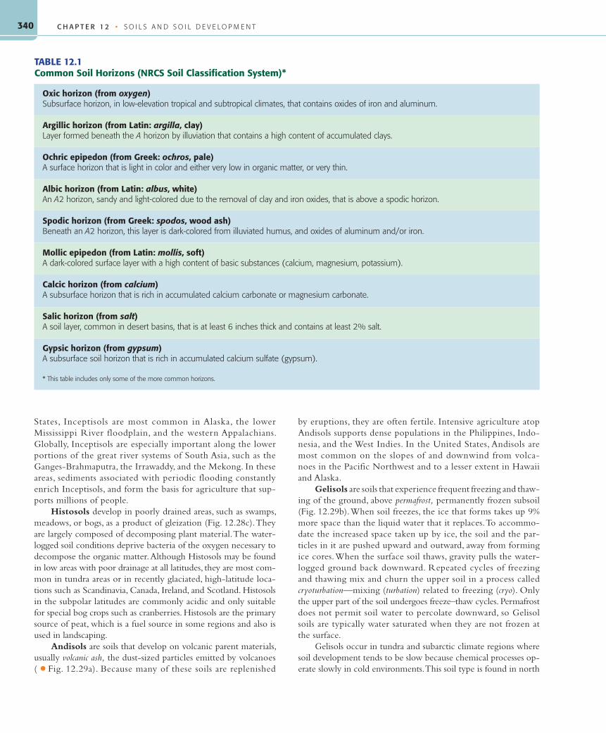
When examining a soil for classification under the NRCS system, particular attention is paid to characteristic horizons and textures. Some of these horizons are below the surface (subsur-face horizons); others, called epipedons, are surface layers that usually exhibit a dark shading associated with organic material (humus). Examples of some of the more common horizons, illus-trating how names were chosen to represent actual soil properties, are found in Table 12.1.
NRCS Soil OrdersThe 12 soil orders are based on a variety of characteristics and processes that can be recognized by examining a soil and its pro-file. The soil descriptions that follow are based on the sequence shown in ● Figure 12.25, which illustrates the links between climate and soils. ● Figure 12.26 is a map showing the distribu-tion of dominant soil orders in the United States. Global soils based on the NRCS classification of soil orders are shown in ● Figure 12.27. Frequent comparison of Figure 12.27 with the map of world climates in Figure 8.6 will illustrate the relation-ships between the global distributions of soil and climate.
Entisols are soils that have undergone little or no soil devel-opment and lack horizons, because they have only recently begun to form ( ● Fig. 12.28a). They are often associated with the con-tinuing erosion of sloping land in mountainous regions or with the frequent deposition of alluvium by flooding, or in areas of windblown sand.
Inceptisols are young soils with weak horizon devel-opment (Fig. 12.28b). The processes of A horizon depletion (eluviation) and B horizon deposition (illuviation) are just be-ginning, usually because of a very cold climate, repeated flood-related deposition, or a high rate of soil erosion. In the United
● FIGURE 12.24Salinization is indicated by these white deposits on this field in Colorado. Surface salinity has resulted from the upward capillary movement of water and evaporation at the surface causing deposits of salt. The soil cracks also indicate shrinkage caused by evaporative drying of the soil.What negative soil effects can result when humans practice irrigated agriculture in regions that experience great evaporation rates?
USDA
/NRC
S/Ti
m M
cCab
e
55061_12_Ch12_p320_347 pp2.indd 33855061_12_Ch12_p320_347 pp2.indd 338 6/5/08 4:29:11 PM6/5/08 4:29:11 PM

339S O I L C L A S S I F I C AT I O N
● FIGURE 12.25The NRCS soil orders. The soil orders of the NRCS can be linked to the parent materials, climate, and vegetation of the region in which they formed. The linkages form a treelike pattern, as seen here.How is degree of weathering related to climatic characteristics?
Inceptisols(beginning)
Tundra regions
Mildweatheringon volcanic
ejecta
Mildweathering
Variousconditions
Variousconditions
Little or nodevelopment
Organicplant material,wet environment
Permanentlyfrozen
subsoil
Warm to hot,high base
status, highactivity clays
Moist, mildlyacid
Broadleafforests
Silicateclays, Fe,Al oxides
Wet tropical andsubtropical forests
Swampy,boggy areas
Dry to desert
Semi arid/moist
grasslands Cool, wet, sandy,
acid
Coniferousforests
Wet, tropicalforests, extreme
weathering
Short grasses,desertshrubs
Mollicepipedon
Andisols(volcanicejecta)
Vertisols(swelling
clays)
Slight StrongIntermediate
Degree of weathering and soil development
Alfisols(mild
forest soil)
Gelisols(permafrost)
Entisols(recent)
Histosols(organics,peat)
Aridisols(dry)
Mollisols(soft)
Ultiisols(ultimate)
Spodosol(spodichorizon)
Oxisolsclays
Fe Al oxides
From
Nat
ure
and
Prop
ertie
s of
Soi
ls, 1
2/e
by B
rady
and
Wei
l, ©
199
8. R
eprin
ted
by p
erm
issi
on o
f Pea
rson
Edu
catio
n, In
c.,
Uppe
r Sad
dle
Rive
r, N
J.
● FIGURE 12.26The distribution of soils in the United States according to the National Resource Conservation Service’s classification.What kind of soil dominates the place where you live, according to this map?
USDA
/NRC
S
55061_12_Ch12_p320_347 pp2.indd 33955061_12_Ch12_p320_347 pp2.indd 339 6/5/08 4:29:13 PM6/5/08 4:29:13 PM
C H A P T E R 1 2 • S O I L S A N D S O I L D E V E L O P M E N T340
States, Inceptisols are most common in Alaska, the lower Mississippi River floodplain, and the western Appalachians. Globally, Inceptisols are especially important along the lower portions of the great river systems of South Asia, such as the Ganges-Brahmaputra, the Irrawaddy, and the Mekong. In these areas, sediments associated with periodic flooding constantly enrich Inceptisols, and form the basis for agriculture that sup-ports millions of people.
Histosols develop in poorly drained areas, such as swamps, meadows, or bogs, as a product of gleization (Fig. 12.28c). They are largely composed of decomposing plant material. The water-logged soil conditions deprive bacteria of the oxygen necessary to decompose the organic matter. Although Histosols may be found in low areas with poor drainage at all latitudes, they are most com-mon in tundra areas or in recently glaciated, high-latitude loca-tions such as Scandinavia, Canada, Ireland, and Scotland. Histosols in the subpolar latitudes are commonly acidic and only suitable for special bog crops such as cranberries. Histosols are the primary source of peat, which is a fuel source in some regions and also is used in landscaping.
Andisols are soils that develop on volcanic parent materials, usually volcanic ash, the dust-sized particles emitted by volcanoes ( ● Fig. 12.29a). Because many of these soils are replenished
by eruptions, they are often fertile. Intensive agriculture atop Andisols supports dense populations in the Philippines, Indo-nesia, and the West Indies. In the United States, Andisols are most common on the slopes of and downwind from volca-noes in the Pacific Northwest and to a lesser extent in Hawaii and Alaska.
Gelisols are soils that experience frequent freezing and thaw-ing of the ground, above permafrost, permanently frozen subsoil (Fig. 12.29b). When soil freezes, the ice that forms takes up 9% more space than the liquid water that it replaces. To accommo-date the increased space taken up by ice, the soil and the par-ticles in it are pushed upward and outward, away from forming ice cores. When the surface soil thaws, gravity pulls the water-logged ground back downward. Repeated cycles of freezing and thawing mix and churn the upper soil in a process called cryoturbation—mixing (turbation) related to freezing (cryo). Only the upper part of the soil undergoes freeze–thaw cycles. Permafrost does not permit soil water to percolate downward, so Gelisol soils are typically water saturated when they are not frozen at the surface.
Gelisols occur in tundra and subarctic climate regions where soil development tends to be slow because chemical processes op-erate slowly in cold environments. This soil type is found in north
TABLE 12.1Common Soil Horizons (NRCS Soil Classification System)*
Oxic horizon (from oxygen)Subsurface horizon, in low-elevation tropical and subtropical climates, that contains oxides of iron and aluminum.
Argillic horizon (from Latin: argilla, clay)Layer formed beneath the A horizon by illuviation that contains a high content of accumulated clays.
Ochric epipedon (from Greek: ochros, pale)A surface horizon that is light in color and either very low in organic matter, or very thin.
Albic horizon (from Latin: albus, white)An A2 horizon, sandy and light-colored due to the removal of clay and iron oxides, that is above a spodic horizon.
Spodic horizon (from Greek: spodos, wood ash)Beneath an A2 horizon, this layer is dark-colored from illuviated humus, and oxides of aluminum and/or iron.
Mollic epipedon (from Latin: mollis, soft)A dark-colored surface layer with a high content of basic substances (calcium, magnesium, potassium).
Calcic horizon (from calcium)A subsurface horizon that is rich in accumulated calcium carbonate or magnesium carbonate.
Salic horizon (from salt)A soil layer, common in desert basins, that is at least 6 inches thick and contains at least 2% salt.
Gypsic horizon (from gypsum)A subsurface soil horizon that is rich in accumulated calcium sulfate (gypsum).
* This table includes only some of the more common horizons.
55061_12_Ch12_p320_347 pp2.indd 34055061_12_Ch12_p320_347 pp2.indd 340 6/5/08 4:33:39 PM6/5/08 4:33:39 PM
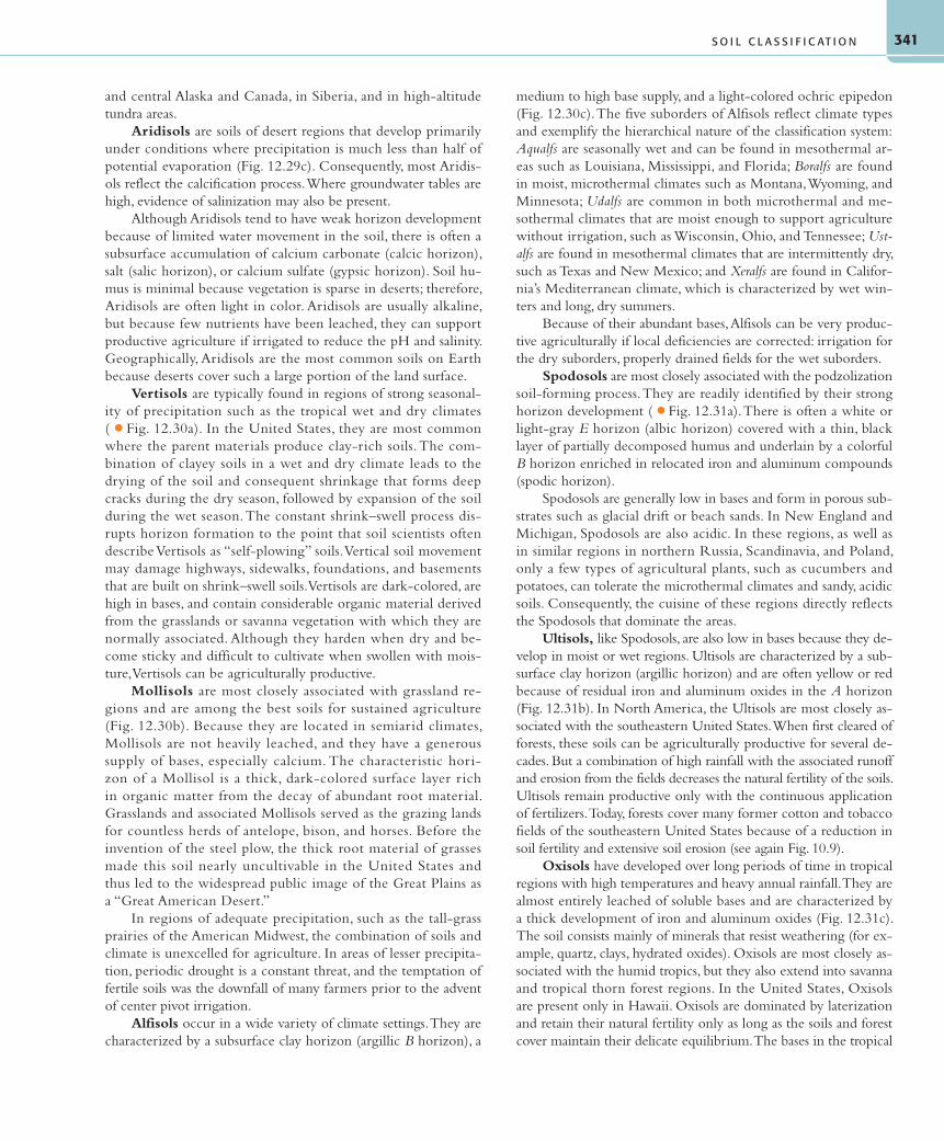
341
and central Alaska and Canada, in Siberia, and in high-altitude tundra areas.
Aridisols are soils of desert regions that develop primarily under conditions where precipitation is much less than half of potential evaporation (Fig. 12.29c). Consequently, most Aridis-ols reflect the calcification process. Where groundwater tables are high, evidence of salinization may also be present.
Although Aridisols tend to have weak horizon development because of limited water movement in the soil, there is often a subsurface accumulation of calcium carbonate (calcic horizon), salt (salic horizon), or calcium sulfate (gypsic horizon). Soil hu-mus is minimal because vegetation is sparse in deserts; therefore, Aridisols are often light in color. Aridisols are usually alkaline, but because few nutrients have been leached, they can support productive agriculture if irrigated to reduce the pH and salinity. Geographically, Aridisols are the most common soils on Earth because deserts cover such a large portion of the land surface.
Vertisols are typically found in regions of strong seasonal-ity of precipitation such as the tropical wet and dry climates ( ● Fig. 12.30a). In the United States, they are most common where the parent materials produce clay-rich soils. The com-bination of clayey soils in a wet and dry climate leads to the drying of the soil and consequent shrinkage that forms deep cracks during the dry season, followed by expansion of the soil during the wet season. The constant shrink–swell process dis-rupts horizon formation to the point that soil scientists often describe Vertisols as “self-plowing” soils. Vertical soil movement may damage highways, sidewalks, foundations, and basements that are built on shrink–swell soils. Vertisols are dark-colored, are high in bases, and contain considerable organic material derived from the grasslands or savanna vegetation with which they are normally associated. Although they harden when dry and be-come sticky and difficult to cultivate when swollen with mois-ture, Vertisols can be agriculturally productive.
Mollisols are most closely associated with grassland re-gions and are among the best soils for sustained agriculture (Fig. 12.30b). Because they are located in semiarid climates, Mollisols are not heavily leached, and they have a generous supply of bases, especially calcium. The characteristic hori-zon of a Mollisol is a thick, dark-colored surface layer rich in organic matter from the decay of abundant root material. Grasslands and associated Mollisols served as the grazing lands for countless herds of antelope, bison, and horses. Before the invention of the steel plow, the thick root material of grasses made this soil nearly uncultivable in the United States and thus led to the widespread public image of the Great Plains as a “Great American Desert.”
In regions of adequate precipitation, such as the tall-grass prairies of the American Midwest, the combination of soils and climate is unexcelled for agriculture. In areas of lesser precipita-tion, periodic drought is a constant threat, and the temptation of fertile soils was the downfall of many farmers prior to the advent of center pivot irrigation.
Alfisols occur in a wide variety of climate settings. They are characterized by a subsurface clay horizon (argillic B horizon), a
medium to high base supply, and a light-colored ochric epipedon (Fig. 12.30c). The five suborders of Alfisols reflect climate types and exemplify the hierarchical nature of the classification system: Aqualfs are seasonally wet and can be found in mesothermal ar-eas such as Louisiana, Mississippi, and Florida; Boralfs are found in moist, microthermal climates such as Montana, Wyoming, and Minnesota; Udalfs are common in both microthermal and me-sothermal climates that are moist enough to support agriculture without irrigation, such as Wisconsin, Ohio, and Tennessee; Ust-alfs are found in mesothermal climates that are intermittently dry, such as Texas and New Mexico; and Xeralfs are found in Califor-nia’s Mediterranean climate, which is characterized by wet win-ters and long, dry summers.
Because of their abundant bases, Alfisols can be very produc-tive agriculturally if local deficiencies are corrected: irrigation for the dry suborders, properly drained fields for the wet suborders.
Spodosols are most closely associated with the podzolization soil-forming process. They are readily identified by their strong horizon development ( ● Fig. 12.31a). There is often a white or light-gray E horizon (albic horizon) covered with a thin, black layer of partially decomposed humus and underlain by a colorful B horizon enriched in relocated iron and aluminum compounds (spodic horizon).
Spodosols are generally low in bases and form in porous sub-strates such as glacial drift or beach sands. In New England and Michigan, Spodosols are also acidic. In these regions, as well as in similar regions in northern Russia, Scandinavia, and Poland, only a few types of agricultural plants, such as cucumbers and potatoes, can tolerate the microthermal climates and sandy, acidic soils. Consequently, the cuisine of these regions directly reflects the Spodosols that dominate the areas.
Ultisols, like Spodosols, are also low in bases because they de-velop in moist or wet regions. Ultisols are characterized by a sub-surface clay horizon (argillic horizon) and are often yellow or red because of residual iron and aluminum oxides in the A horizon (Fig. 12.31b). In North America, the Ultisols are most closely as-sociated with the southeastern United States. When first cleared of forests, these soils can be agriculturally productive for several de-cades. But a combination of high rainfall with the associated runoff and erosion from the fields decreases the natural fertility of the soils. Ultisols remain productive only with the continuous application of fertilizers. Today, forests cover many former cotton and tobacco fields of the southeastern United States because of a reduction in soil fertility and extensive soil erosion (see again Fig. 10.9).
Oxisols have developed over long periods of time in tropical regions with high temperatures and heavy annual rainfall. They are almost entirely leached of soluble bases and are characterized by a thick development of iron and aluminum oxides (Fig. 12.31c). The soil consists mainly of minerals that resist weathering (for ex-ample, quartz, clays, hydrated oxides). Oxisols are most closely as-sociated with the humid tropics, but they also extend into savanna and tropical thorn forest regions. In the United States, Oxisols are present only in Hawaii. Oxisols are dominated by laterization and retain their natural fertility only as long as the soils and forest cover maintain their delicate equilibrium. The bases in the tropical
S O I L C L A S S I F I C AT I O N
55061_12_Ch12_p320_347 pp2.indd 34155061_12_Ch12_p320_347 pp2.indd 341 6/5/08 4:33:47 PM6/5/08 4:33:47 PM

C H A P T E R 1 2 • S O I L S A N D S O I L D E V E L O P M E N T342
● FIGURE 12.27The global distribution of soils by NRCS soil orders.How do these patterns resemble the spatial distribution of world climates?
USDA
/NRC
S
55061_12_Ch12_p320_347 pp2.indd 34255061_12_Ch12_p320_347 pp2.indd 342 6/5/08 4:33:49 PM6/5/08 4:33:49 PM

343S O I L C L A S S I F I C AT I O N
55061_12_Ch12_p320_347 pp2.indd 34355061_12_Ch12_p320_347 pp2.indd 343 6/5/08 4:33:54 PM6/5/08 4:33:54 PM

C H A P T E R 1 2 • S O I L S A N D S O I L D E V E L O P M E N T344
rainforests are stored mainly in the vegetation. When a tree dies, epiphytes and insects must recycle the bases rapidly before the heavy rainfall leaches them from the system.
The burning of vegetation associated with slash-and-burn agriculture in rainforests releases the nutrients necessary for crop
growth but quickly results in their loss from the ecosystem. Many tropical Oxisols that once supported lush forests are now heavily dissected by erosion and only support a combination of weeds, shrubs, and grasses.
● FIGURE 12.28Soil profile examples: (a) Entisols, (b) Inceptisols, and (c) Histosols.
(c)
© H
ari E
swar
an, U
SDA/
NRC
S
© H
ari E
swar
an, U
SDA/
NRC
S
© H
ari E
swar
an, U
SDA/
NRC
S
(a) (b)
● FIGURE 12.29Soil profile examples: (a) Andisols, (b) Gelisols, and (c) Aridisols.
© H
ari E
swar
an, U
SDA/
NRC
S
© H
ari E
swar
an, U
SDA/
NRC
S
© H
ari E
swar
an, U
SDA/
NRC
S
(c)(a) (b)
55061_12_Ch12_p320_347 pp2.indd 34455061_12_Ch12_p320_347 pp2.indd 344 6/5/08 4:34:03 PM6/5/08 4:34:03 PM

345
Soil as a Critical Natural Resource
Regardless of their composition, origin, or state of development, Earth’s soils remain one of our most important and vulnerable resources. The word fertility, so often associated with soils, has a meaning that takes into consideration the usefulness of a soil to
humans. Soils are fertile in respect to their effectiveness in pro-ducing specific vegetation types or associations. Some soils may be fertile for corn and others for potatoes. Other soils retain their fertility only as long as they remain in delicate equilibrium with their vegetative cover.
It is clearly the responsibility of all of us who enjoy the agricultural products of farms, ranches, and orchards, as well as appreciate the natural beauty of Earth’s diverse biomes,
● FIGURE 12.30Soil profile examples: (a) Vertisols, (b) Mollisols, and (c) Alfisols.
© H
ari E
swar
an, U
SDA/
NRC
S
© H
ari E
swar
an, U
SDA/
NRC
S
© H
ari E
swar
an, U
SDA/
NRC
S
(c)(a) (b)
● FIGURE 12.31Soil profile examples: (a) Spodosols, (b) Ultisols, and (c) Oxisols.
S O I L A S A C R I T I C A L N AT U R A L R E S O U R C E
© H
ari E
swar
an, U
SDA/
NRC
S
© H
ari E
swar
an, U
SDA/
NRC
S
© H
ari E
swar
an, U
SDA/
NRC
S
(c)(a) (b)
55061_12_Ch12_p320_347 pp2.indd 34555061_12_Ch12_p320_347 pp2.indd 345 6/5/08 4:34:17 PM6/5/08 4:34:17 PM
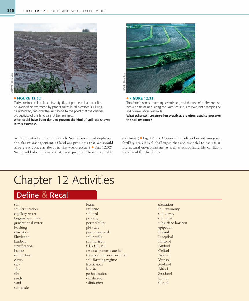
C H A P T E R 1 2 • S O I L S A N D S O I L D E V E L O P M E N T346
to help protect our valuable soils. Soil erosion, soil depletion, and the mismanagement of land are problems that we should have great concern about in the world today ( ● Fig. 12.32). We should also be aware that these problems have reasonable
solutions ( ● Fig. 12.33). Conserving soils and maintaining soil fertility are critical challenges that are essential to maintain-ing natural environments, as well as supporting life on Earth today and for the future.
soilsoil fertilizationcapillary waterhygroscopic watergravitational waterleachingeluviationilluviationhardpanstratificationhumussoil textureclayeyclaysiltysiltsandysandsoil grade
loaminfiltratesoil pedporositypermeabilitypH scaleparent materialsoil profilesoil horizonCl, O, R, P, Tresidual parent materialtransported parent materialsoil-forming regimelaterizationlateritepodzolizationcalcificationsalinization
gleizationsoil taxonomysoil surveysoil ordersubsurface horizonepipedonEntisolInceptisolHistosolAndisolGelisolAridisolVertisolMollisolAlfisolSpodosolUltisolOxisol
Chapter 12 ActivitiesDefine & Recall
USDA
/NRC
S/Ly
nn B
etts
● FIGURE 12.32Gully erosion on farmlands is a significant problem that can often be avoided or overcome by proper agricultural practices. Gullying, if unchecked, can alter the landscape to the point that the original productivity of the land cannot be regained.What could have been done to prevent the kind of soil loss shown in this example?
● FIGURE 12.33This farm’s contour farming techniques, and the use of buffer zones between fields and along the water course, are excellent examples of soil conservation methods.What other soil conservation practices are often used to preserve the soil resource?
USDA
/NRC
S/Ly
nn B
etts
55061_12_Ch12_p320_347 pp2.indd 34655061_12_Ch12_p320_347 pp2.indd 346 6/5/08 4:34:29 PM6/5/08 4:34:29 PM

347347
1. Why is soil an outstanding example of the integration and interaction among Earth’s subsystems?
2. Describe the different circumstances in which water is found in soil.
3. Under what conditions does leaching take place? What is the effect of leaching on the soil and, consequently, on the vegetation that it supports?
4. How can capillary water contribute to the formation of caliche? What is the effect of caliche on drainage?
5. How is humus formed? What relation does humus have to soil fertility?
6. How is texture used to classify soils? Describe the ways scientists have classified soil structure.
7. What pH range indicates soil suitable for most complex plants?
8. What are the general characteristics of each horizon in a soil profile? How are soil profiles important to scientists?
9. What factors are involved in the formation of soils? Which is most important on a global scale?
10. How does transported parent material differ from residual parent material? List those factors that help determine how much effect the parent material will have on the soil.
11. What are the most important effects of parent material on soil?
12. How does the presence of earthworms and other burrowing animals affect soil?
13. Describe the various ways in which temperature and precipitation are related to soil formation.
14. Describe the three major soil-forming regimes.
Discuss & Review
1. Refer to Figure 12.13 and associated pages in the text.a. What horizons make up the zone of eluviation?b. What are two processes that occur in the zone of eluviation?c. The various B horizons are in what zone?d. Weathered parent material is the major constituent of
what horizon?e. Partly decomposed organic debris makes up which horizon?
2. Refer to Table 12.1.a. What materials accumulate in an argillic horizon?
b. Which would generally be better suited for agriculture—a soil with an ochric epipedon or a mollic epipedon? Why?
c. What name would be given to a 7-inch-thick horizon that contained at least 2% salt?
3. Where would you rank soils in terms of importance among a nation’s environmental resources?
4. Give your opinion of the overall value of soils in the United States and the extent to which these soils are preserved and protected.
Consider & Respond
1. Refer to Figure 12.8. Using the texture triangle, determine the textures of the following soil samples.
What are the percentages of sand, silt, and clay of the following soil textures? (Note: Answers may vary, but they should total 100%.)
e. Sandy clay f. Silty loam
2. Obtain a small sample of soil (a handful or so) and try to dis-cover its texture by using the following method: Wet the soil a bit and work it in your hand.
I. First, if you can form a ribbon of soil by kneading it with your fingers:
If you can form a ribbon that is long relatively strong and flexible: the soil is a clay.
If you can form a ribbon that is weak and breaks easily, and the soil can be rolled into a coherent ball: the soil is a clay loam.
If the clay loam looks powdery when dry: the soil is a silty clay loam.
If the clay loam has a gritty feel with visible sand: it is a sandy clay loam.
II. Second, if you cannot form a ribbon because the soil breaks up:
If damp soil breaks up easily, but is gritty, yet still sticky enough to make a ball: the soil is a loam.
If it feels gritty and sand can be seen, and the ball breaks up easily in your hands: the soil is a sandy loam.
III. Third, if the soil is very loose with visible grains of about the same size:
If you can see grains in the soil, and the mass in your hand breaks up easily: the soil is a sand.
Apply & Learn
C H A P T E R 1 2 A C T I V I T I E S
Sand Silt Clay
a. 35% 45% 20%b. 75% 15% 10%c. 10% 60% 30%d. 5% 45% 50%
55061_12_Ch12_p320_347 pp2.indd 34755061_12_Ch12_p320_347 pp2.indd 347 6/5/08 4:34:34 PM6/5/08 4:34:34 PM


