5a 15/1260 Reg’d: 19.11.2015 Expires: 31.07.16 Ward: Canalside Nei . Con . Exp : 14.12.15 02.06.16 BVPI Target: 006 Number of Weeks on Cttee’ Day: 36 On Target ? Y LOCATION: Sheerwater Estate, Albert Drive, Sheerwater PROPOSAL: Hybrid planning application (part outline, part full planning application): for the demolition of 576 residential units, existing non-residential buildings and sports facilities and redevelopment of the site to be implemented in phases with the associated engineering works to provide a mixed-use development comprising: up to 922 residential units (Class C3), 62 units (Class C2), up to 1,110sqm community/youth centre and up to 600sqm (nursery/children’s centre) (Class D1), up to 5,478sqm Leisure Centre (Class D2), 1,650sqm retail (flexible use within Class A1 and/or A2 and/or A3 and/or A4 and/or A5), up to 416sqm health centre (Class D1), an artificial grass pitch (AGP), with spectator seating, erection of sports amenity lighting, improvements to Bishop David Brown School playing fields, a new substation, formation of car park including bus/coach drop-off area, hard and soft landscaping and open space with a multi-use games area (MUGAs) and a skate park, reconfigured and new vehicular and pedestrian accesses and works to the public highway and associated works; including full planning application for detailed first phase comprising: demolition of 5 residential units, 903sqm of ancillary buildings at Bishop David Brown School and existing athletics track and construction of 92 residential units (11no. 2-bed units, 39no. 3-bed units, 39no. 4-bed units and 3no. 5-bed units), 5,478sqm Leisure Centre (Class D2), an artificial grass pitch (AGP) with spectator seating, erection of sports 1
LOCATION: Sheerwater Estate, Albert Drive, Sheerwater
PROPOSAL: Hybrid planning application (part outline, part full planning application): for the demolition of 576 residential units, existing non-residential buildings and sports facilities and redevelopment of the site to be implemented in phases with the associated engineering works to provide a mixed-use development comprising: up to 922 residential units (Class C3), 62 units (Class C2), up to 1,110sqm community/youth centre and up to 600sqm (nursery/children’s centre) (Class D1), up to 5,478sqm Leisure Centre (Class D2), 1,650sqm retail (flexible use within Class A1 and/or A2 and/or A3 and/or A4 and/or A5), up to 416sqm health centre (Class D1), an artificial grass pitch (AGP), with spectator seating, erection of sports amenity lighting, improvements to Bishop David Brown School playing fields, a new substation, formation of car park including bus/coach drop-off area, hard and soft landscaping and open space with a multi-use games area (MUGAs) and a skate park, reconfigured and new vehicular and pedestrian accesses and works to the public highway and associated works; including full planning application for detailed first phase comprising: demolition of 5 residential units, 903sqm of ancillary buildings at Bishop David Brown School and existing athletics track and construction of 92 residential units (11no. 2-bed units, 39no. 3-bed units, 39no. 4-bed units and 3no. 5-bed units), 5,478sqm Leisure Centre (Class D2), an artificial grass pitch (AGP) with spectator seating, erection of sports amenity lighting, improvements to Bishop David Brown School playing fields, a new substation, formation of car park including bus/coach drop off area, with hard and soft landscaping and open space, reconfigured and new vehicular and pedestrian access and works to the public highway.
TYPE: HYBRID (PART OUTLINE PART FULL APPLICATION)
APPLICANT: Woking Housing Partnership Ltd(trading as New Vision Homes)
OFFICER: Joanne Hollingdale
REASON FOR REFERRAL TO COMMITTEE
The proposed development is for major development and is thus outside the scope of the Scheme of Delegation.
PLANNING STATUS
1
Urban area Thames Basin Heaths SPA Zone b 400m-5km Tree Preservation Order Basingstoke Canal SSSI Basingstoke Canal Conservation Area Flood Zone 1 and 2 Priority Place Area of High Archaeological Potential Urban Open Space Local Centre
SUMMARY OF RECOMMENDATION
1. Subject to the prior resolution of the Council’s Executive to give effect to the measures detailed in the recommendation at the end of this report; and
2. To GRANT planning permission subject to conditions (and any minor amendments to those conditions).
SITE DESCRIPTION
The application site is located in Sheerwater and lies approximately 1.9km to the north-east of Woking and 1.3km to the west of West Byfleet. Sheerwater is defined by the Basingstoke Canal to the north, the railway to the south, light industrial units to the west and the Sheerwater Road to the east.
The application site covers an area of approximately 29.94 hectares and is irregular in shape as it follows the alignment of the Basingstoke Canal to the north. The topography of the site is relatively flat with a levels variation of around 3 metres (reduction) from west to east across the whole of the application site, although there are embankments to the Basingstoke Canal.
The layout of the application site currently comprises residential dwellings/flats with scattered green spaces throughout. A strip of mature woodland is located to the north and runs along the alignment of the Basingstoke Canal. A linear form of commercial/retail units is located towards the centre of the site along Dartmouth Avenue. A large recreational ground is located to the northern part of the site which contains a children’s playground, athletics track, floodlit multi-use games area (MUGA) and two football pitches.
Broadmere Primary School and Bishop David Brown Secondary School are located to the eastern part of the site. Broadmere Primary School and the adjacent Kiddiwinks Nursery are excluded from the planning application site. The majority of the buildings of Bishop David Brown Secondary School are also excluded from the planning application site but its playing fields and access/parking area are included within the application site.
The primary land use within the application site is residential with the retail provision comprising the local centre. Other facilities located within the application site are:
Sheerwater Youth Centre Woking Sure Start Children’s Centre and Nursery Woking Athletics Club pavilion and athletics track Parkview Community Centre Sheerwater Health Centre and Waterside Dental Centre The Birch and Pines Public House Sheerwater Football Club
2
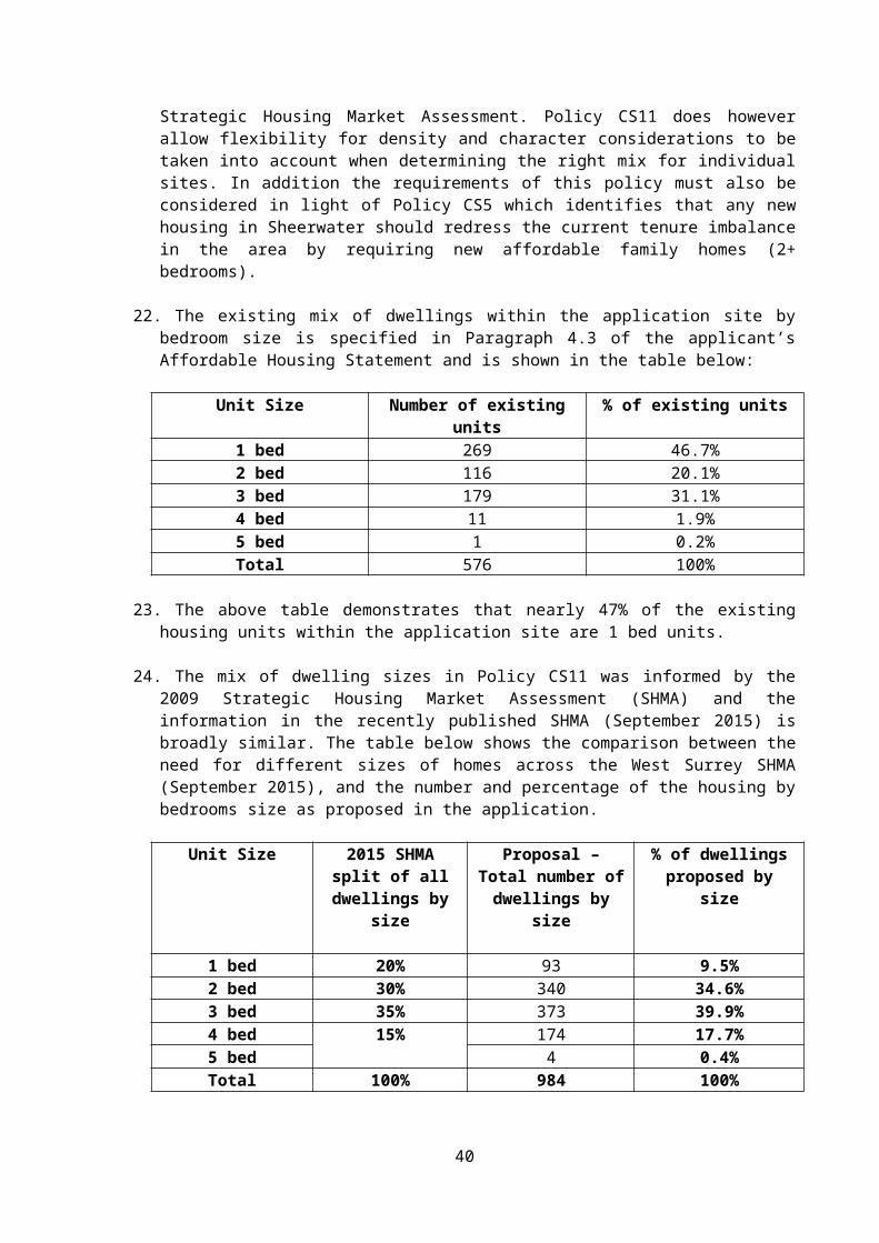
The majority of buildings within the application site are two storey, although the local centre is defined by a 4 storey mixed use block with surrounding 3 storey residential blocks.
Due to the constraining features of the Basingstoke Canal to the north and the railway line to the south of Sheerwater, there are only two ways in and out of the application site. The application site can be accessed from Woking Town Centre to the west and from West Byfleet to the east by Albert Drive which diverts along the southern boundary of Sheerwater but falls within the planning application site at its western and eastern ends. There are no means to cross the canal or the railway from within the Sheerwater estate area.
Sheerwater is well served by public transport with local bus services which provide access to Woking, Byfleet, Weybridge and Staines including access to the railway stations at Woking and West Byfleet. The Sheerwater Estate also has pedestrian footways on both sides of the carriageways giving access to local facilities and bus stops and pedestrian access to the Basingstoke Canal towpath. The Sheerwater Estate also lies on two of the ‘Planet Trail’ cycle routes, the Saturn trail which goes along the canal towpath and the Ceres cycleway which passes through the centre of Sheerwater.
PLANNING HISTORY
There is planning history for the individual buildings within this application site but there are no previous planning applications relating to this application site as a whole.
PROPOSED DEVELOPMENT
This application is a hybrid application which seeks part outline planning permission and part full planning permission for the development as detailed below:
Outline planning application for the demolition of 576 homes, existing non-residential buildings and sports facilities within the application boundary to construct a mixed use development comprising of:
Up to 922 residential units (Class C3); 62 units (Class C2 – residential institution); Up to 1,110sqm community/youth centre; Up to 600sqm nursery/children’s centre (Class D1); Up to 5,478sqm Leisure centre (Class D2); 1,650sqm retail (flexible use within Class A1 and/or A2 and/or A3 and/or A4
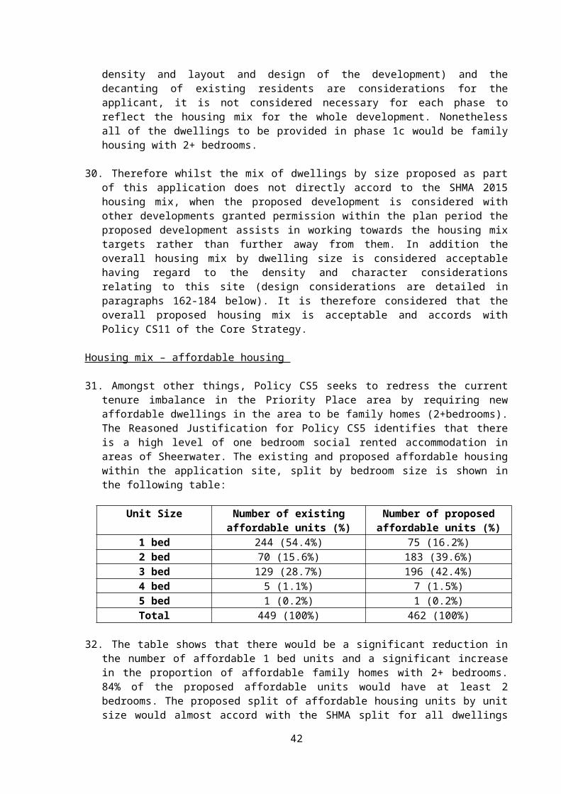
and/orA5); Up to 416sqm health centre (Class D1); Artificial grass pitch (AGP), with spectator seating, erection of sports amenity lighting,
improvements to Bishop David Brown School playing fields, a new substation, formation of car park including bus/coach drop-off area;
Hard and soft landscaping and open space with a multi-use games area (MUGAs) and a skate park, and
Reconfigured and new vehicular and pedestrian accesses and works to public highway.
Summary of existing residential units to be demolished and replaced as part of the proposal
To be demolished To be provided Net increase
Class C3 (dwellings) 559 922 363Class C2 (residential institutions)
17 62 45
3
Total 576 984 408
Submitted with the outline application is a set of parameter plans which propose: The application boundary; Open space, recreation and play typologies i.e. showing the types and site areas of
the proposed open space and recreation areas; Access and movement i.e. showing the primary routes into the site, the secondary
routes within the site and pedestrian only access points; Building heights i.e. showing the proposed maximum heights of the development
for each defined area; Proposed site levels i.e. showing the minimum and maximum site levels for each
defined area; Land use i.e. showing the residential zones and the mixed use zones Phasing; Sub-phasing; and Detailed phasing.
A Design Code has also been submitted to guide future reserved matters applications.
Access is a detailed matter to be determined at the outline stage with layout, scale, appearance and landscaping being the reserved matters.
Two primary access points into the application site are shown both off the existing Albert Drive. To the eastern end of the site the existing roundabout of Albert Drive with Devonshire Avenue is identified as a primary vehicular access point into the site and to the western end of the site the junction of Albert Drive with Devonshire Avenue (opposite Asda) is identified as the second primary vehicular access point into the site. Although between these two vehicular access points within the application site the road layout will change from that which currently exists.
The anticipated construction period for the proposed development is 9 years. It is stated in the Planning Statement that the phasing strategy will ensure as far as possible that:
There is no loss of publicly accessible open space prior to re-provision; There is no loss of community facilities prior to re-provision; Existing buildings and properties will not be demolished until appropriate re-provision
is complete; As many existing Council tenants as possible can be relocated to a new property
within Sheerwater, should they wish to do so; As many existing residential freeholders and leaseholders will have the opportunity
to acquire a new property within Sheerwater should they wish to do so.
The applicant has also submitted an illustrative master plan with the application which shows one example of how the site could be developed.
Full planning application for a detailed phase 1 (a, b and c) for the demolition of 5 homes and 903sqm of ancillary buildings at Bishop David Brown School and existing athletics track and the provision of:
92 residential units (11no. 2-bed units, 39no. 3-bed units, 39no. 4-bed units and 3no. 5-bed units);
5,478sqm Leisure Centre (Class D2); Artificial grass pitch (AGP), with spectator seating, erection of sports amenity lighting,
improvements to Bishop David Brown School playing fields, a new substation, formation of car park including bus/coach drop-off area;
with hard and soft landscaping and open space; reconfigured and new vehicular and pedestrian access; and works to the public highway.
4
Phase 1a and 1b comprise the construction of a new leisure centre and upgraded playing fields on land surrounding Bishop David Brown Secondary School and Broadmere Primary school.
The leisure centre building would be located on land between the two existing schools and will take access off the existing roundabout serving Bishop David Brown Secondary School. The leisure centre building will measure around 61 metres in width by 70 metres in depth with a flat roof with a maximum height of 10.5 metres on the front elevation. The leisure centre will contain:
a 5 court sports hall with associated changing facilities; a 6 lane 25m x 13m swimming pool with approx. 50 spectator seats and a 13m x
10m learner pool; a shared changing village for both pools; 2 studio rooms; 80 station gym/fitness suite; A function room for local sports clubs; and 4 sets of changing rooms to service outdoor sports pitches.
The outdoor sports pitches include: A 3G all-weather football pitch designed to FA Step 5 standard (with spectator
stands); Markings for two junior/5-a-side football pitches; An U16 grass football pitch and an U13/14 grass football pitch; A grass rugby pitch; Markings for a 200m running track; A cricket square with artificial wicket and 2 cricket practice nets; and Access to the 6 existing tennis courts.
A car park providing 141 car parking spaces will also be provided. The new leisure centre will include a sports hall and new dining and catering facilities to support the growth of the Bishop David Brown Secondary School.
Phase 1c – proposes the demolition of 5 existing dwellings and the provision of 92 dwellings comprising:
11no. 2 bed dwellings (including 2no. flats over garages (FOGs)); 39no. 3 bed dwellings; 39no. 4 bed dwellings; and 3no. 5 bed dwellings.
79 units will be for open market sale with 13 units (14%) being affordable units. 4 of the open market units will be delivered later in the phasing to enable vehicular access to Phase 1c. These 4 units are not proposed to be delivered until the existing properties in Spencer Close and Hennessey Court have been vacated.
Of the 92 units proposed as Phase 1c, there would be 14no. detached dwellings with the remainder being formed by semi-detached dwellings, small terraces and 2no. flats over garages (FOG). In respect of housing design, 14 different housing types are proposed, although there may be some variation in the floor plans of these dwellings. Building heights for the development range from between two and three storeys. All of the buildings would have pitched roofs with variations in ridge heights ranging from around 9.1 metres high for the flats over garages, 8.2-11 metres for the two storey dwellings and 10.9-11.8 metres for the three storey dwellings. Each dwelling would have its own garden. The two FOGs would not have a private garden. Each dwelling would have a designated bin store and cycle store
5
– for those dwellings with no external access to their rear garden these will be within the front garden area.
In terms of parking, all of the detached dwellings and semi-detached dwellings to the northern, eastern and southern boundaries of the site would have their own in-curtilage parking. The reminder of the development would have their parking either within their curtilage, to the rear of their property or within the designated parking areas to the front of the dwellings accessed directly off the carriageway. The 2no. FOGs (2 bed) will each have 1 parking space with all of the other dwellings having at least 2 parking spaces. 16no. visitor spaces are also proposed.
Within the development, main vehicular routes have been designated as secondary routes (the primary routes are the main spine routes through the site) with the other streets forming tertiary routes which provide for shared surface streets which give priority to pedestrians.
For phase 1c, four character areas have been defined within the Design and Access Statement namely, Park Edge (facing the linear park to the western boundary), Canal side (to the northern part of the site adjacent to the canal), Avenues (to the eastern boundary of the site) and Mews (at the centre of the development). All of the buildings would have pitched roofs with brick elevations, grey framed windows and some dwellings will have tile hanging to their front elevations.
Supporting Documents
The proposed development falls within Schedule 2 of the Town and Country Planning (Environmental Impact Assessment) Regulations 2011 (as amended) as an urban development project.
An Environmental Statement has been submitted with the application which assesses the environmental impacts of the proposed development. Prior to the formal submission of the current application the applicant requested a scoping opinion in July 2014 to ascertain what matters needed to be included in the environmental impact assessment. The Council adopted its scoping opinion in August 2014. The issues included in the Environmental Statement are; community effects, ecology and nature conservation, noise and vibration, air quality, traffic and transportation, ground conditions and contamination, water resources and environment, townscape and visual amenity, cultural heritage, daylight and sunlight and sustainability, energy and climate change.
The following documents were submitted by the applicant in support of the application:
Environmental Statement with appendices Non-Technical Summary of Environmental Statement
Planning Statement CIL FormsDesign and Access Statement (& Open Space Strategy)
Playing Pitch Assessment (rec 7.12.15)
Design Code Affordable Housing StatementFlood Risk Assessment Transport AssessmentTravel Plan Demolition StatementWaste Management Plan Utilities StatementRetail Statement Community Value PlanStatement of Community Involvement
During the application process the following documents were submitted:
6
Planning Clarifications report and associated amended/additional plans/documents
Addendum to the Environmental Statement dated May 2016
Flood Risk Assessment (February 2016) Addendum to the Transport Assessment dated May 2016
Amended parameter plans Updated CIL scheduleAdditional parameter plan (detailed phasing) Revised Section 6 of the Flood Risk
Assessment (June 2016) and associated drainage plans
CONSULTATIONS
County Highway Authority (first response) – the submitted Transport Assessment is deficient as it does not provide sufficient information for assessment regarding trip generation/trip distribution, pedestrian and cyclist infrastructure and bus service capacity, other matters e.g. refuse vehicle tracking. Comments are also made with regard to the detailed phase 1c housing layout.
County Highway Authority (second response) – there are no points that remain outstanding from the previous response and recommended conditions and informatives are set out for inclusion on any planning permission granted (conditions 33, 34, 35, 36, 37, 76, 77, 78, 79, 80, 81, 82 and 83).
SCC Education Authority – SCC seek contributions based on the number of pupils that it is estimated this development would yield. It is anticipated that the development would yield between 249 and 250 school age children that would require school places. The contributions sought are as follows:
Early Years contributions - £232,875 Primary School contributions - £1,732,474 Secondary School contributions - £2,052,366
SCC Countryside (Rights of Way) – No objection and no comments to make
SCC Lead Local Flood Authority – Subject to your Flood Risk Engineer being satisfied with the proposal we would have no further comments to make.
SCC County Archaeologist – There is potential for palaeoenvironmental remains on the site and as the proposed development will lead to the destruction of any archaeological assets that may be present, in line with the NPPF, further archaeological work is required but as there are unlikely to be remains of a standard to necessitate preservation in-situ securing these archaeological works as a condition of any permission granted would be acceptable. A condition requiring a programme of archaeological works is therefore required (condition 32).
SCC Landscape Officer – A large number of County planning applications are currently prioritised and therefore I am unable to provide any useful comment on this application. However I have reviewed the EIA and the Townscape and Visual Assessment and I would consider it to be based on sound methodology developed from the Guidelines for Landscape and Visual Impact Assessment alongside most recent landscape character assessment guidance as published by Natural England. The impact of the proposed development on landscape character to be considered as part of townscape character is in accordance with these areas of guidance.
7
Environment Agency – Woking Borough Council should assess and determine if the sequential test has been passed. The Basingstoke Canal is a Site of Special Scientific Interest (SSSI) and is particularly valuable for wildlife and it is essential that it is protected. Planning permission could be granted for the development if the recommended conditions are included on any permission granted (conditions 40, 41 and 99).
Natural England (first response) – Object – due to a lack of information relating to the impact of the proposed development on the Basingstoke Canal SSSI. The information requested relates to the proposed drainage strategy/system for the proposed development. It is understood that the proposals are meeting the Council’s Avoidance and Mitigation Strategy for the Thames Basin Heaths SPA in respect of SANG and SAMM. If this is the case then Natural England does not object to this application in this respect [Officer note: SANG is dealt with as part of CIL].
Natural England (second response) – No objection - Natural England has reviewed the amended/additional information provided in support of this planning application and in light of the submission of this information Natural England is now satisfied that the proposed development, being carried out in strict accordance with the details of the application, will not damage or destroy the interest features for which the Basingstoke Canal SSSI has been notified. We therefore withdraw our earlier objection to the application. Please refer to the earlier response for comments in relation to the other matters.
Sport England (first response) – Having assessed the proposed development against Sport England Policy and the NPPF, it is considered that the proposed new sporting facilities together with the proposed replacement are of sufficient benefit to the development of sport as to outweigh the detriment caused by the loss of the playing field. Given the significant benefits for sport arising from this development combined with the new sports facilities proposed at Egley Road (PLAN/2015/0703) Sport England is minded not to object to the proposed application taking into account the special circumstances relevant to this application subject to conditions being attached to any planning permission granted. Should the conditions recommended not be imposed Sport England would consider the proposal not to meet their objectives and would object to this application (conditions 23, 24, 25, 58, 59, 60, 61, 62, 75, 104 and 112).
Sport England (second response) – re-provided earlier comments and confirmed Sport England would expect to see the athletics track re-provided at Egley Road before the athletics track at Sheerwater is demolished which should be secured through the planning conditions. If this not secured would wish to object as set out in our response.
Surrey Wildlife Trust – With regard to the impact of the proposed development on the Thames Basin Heaths SPA, the Authority should take advice from Natural England and consult their own Avoidance and Mitigation Strategy. The ecological information provides much useful information to assess the status of protected and important species and the likely effect of the development on them. Should the Local Planning Authority be minded to grant planning permission, the applicant should be required to undertake all of the recommended actions and biodiversity enhancements as detailed in the application. The detailed species survey work only applies to the initial (full planning) phase of the development and therefore the Local Planning Authority should ensure that all of the additional required survey work is undertaken for later phases. Particular attention should be given to protecting the Basingstoke Canal SSSI from development works and post-development use and that the opportunity should also be taken to improve the condition of the SSSI i.e. the 20m buffer zone and management of the woodland fringe to improve light levels. Although no reptiles were found during survey work, further survey work of suitable habitat within gardens affected by development is likely to be required and a possible on-site translocation area may be required and should be identified within development plans at
8
an early stage in any future phases of the proposed development. A Construction and Ecology Management Plan to help protect biodiversity value during development and a Landscape and Ecology Management Plan for public spaces to help develop and maintain biodiversity value on site thereafter should be required (conditions 16, 17, 18, 19, 38, 39, 40, 41, 100 and 101).
Historic England – The application should be determined in accordance with national and local policy guidance and on the basis of your specialist conservation advice.
Thames Water – Thames Water has identified an inability of the existing waste water infrastructure to accommodate the needs of this development. Should planning permission be granted a Grampian condition should be imposed preventing the commencement of development until a drainage strategy detailing any on/off site works has been approved by the Local Planning Authority in consultation with the sewerage undertaker. No discharge of foul or surface water from the site shall be accepted into the public system until the approved strategy works have been completed. With regard to surface water drainage it is the responsibility of the developer to make proper provision for surface water drainage. An informative is also recommended (condition 21 and informatives 12, 13 and 14).
National Grid – No response received. Any comments received will be reported verbally.
Network Rail – No objection and no observations to make.
Basingstoke Canal Authority (first response) – Any works outside of the application site will need to be subject of a legal agreement with the BCA and SCC (as landowners). Ecology - BCA support the approach of a 10m wide buffer strip between the canal and development being maintained as a wildlife corridor. BCA supports the selective reduction of trees within the buffer strip, particularly those causing shading as trees were not historically along the canal. Selective tree removal will reduce over-shading to promote the plants for which the Canal has citation as a SSSI. BCA also supports reduction of large trees on embankments which may damage the embankment and lead to catastrophic failure of the canal if trees are wind thrown. BCA is concerned about the sports pitch lighting which is likely to be detrimental to bats and the lighting levels should be reduced further.
Flood Risk – BCA objects to the provision of a bund at the bottom of the canal embankment as there appears to be no rationale for it and in the highly unlikely event of catastrophic failure of the canal (which is reduced through regular inspections) the water volume would clearly overwhelm the proposed bund. In addition no engineering assessment has been made of the effect of the bund on the embankment (225 year old structure) as the bund is also likely to affect the way in which the embankment drains. Objection is raised to the bund as potentially having a detrimental effect on the embankment which could potentially increase risk rather than reducing it.
Transport Assessment – The submitted TA suggests that the canal towpath (part of the Saturn Trail) is able to accommodate the additional cycle traffic generated by this development which proposes two new links to the towpath from the development. The BCA disagrees with the assessment and this part of the towpath is below standard for a shared cycleway/footway. Cycling is permitted on the towpath but there is no public right to cycle. An increasing number of complaints are received by the BCA regarding pedestrian/cycle conflicts. The TA is therefore flawed as we would have expected a study to demonstrate that the proposed additional traffic (pedestrian/cycle) can be accommodated safely and if it cannot be accommodated then mitigations such as route widening should be included.
Basingstoke Canal Authority (second response) – An agreement with SCC or the BCA will be required for any works on SCC land. Ecology – the BCA is content with the revisions
9
to the proposed lighting scheme in respect of light spill and impact on bats within the “dark corridor”. There are significant conservation and engineering reasons for the selected reduction of large trees within the 20 canal corridor but most of the canal corridor is outside the application site. The BCA would wish to ensure that either the applicant undertakes to make a meaningful contribution towards the environmental management of the 20m buffer zone or carries out an agreed scheme of works to the buffer zone itself to be secured either by agreement or condition.
Flood risk - The BCA does not agree with the applicant’s conclusion that there is an overtopping risk from the canal during severe storm conditions but following the additional information we have a greater understanding why this is conclusion is being retained. Whilst the canal is actively managed their weir and water level management procedures mean that all measures will be taken to ensure no overtopping occurs on tall embankments to avoid the risk of erosion to the fragile earth structures resulting in a catastrophic breach. In our view the bund is entirely unnecessary but I am reassured now that an engineering assessment has been made that the proposed bund will not have any adverse effect on the 225 year old embankment structure. The BCA’s objection to the siting of the bund is therefore withdrawn.
Transport Assessment – the BCA is concerned at the effect of the proposed development on the existing shared use Canal towpath route which forms part of the Saturn Trail and we are not persuaded by the applicant’s additional information and it does nothing to address the evidence we have due to the failure to adhere to the Department of Transport guidance when the towpath was designated a shared route. The Canal towpath is already at or near to capacity. The applicant’s suggestion that cycle generation will be as low as 7 cycle journeys per hour is incorrect and they have relied on a model rather than undertaking primary research. The development is situated an ideal distance for a short commute into the town centre which will encourage users and it will also be used for recreation purposes. The applicant’s suggestion that cyclists will prefer Albert Road route over the more pleasant traffic free route is an opinion and an unsound conclusion. It is therefore not safe to conclude that the existing network can accommodate the functional and recreational use that will be generated by the proposed development. This conclusion could only be reached if there is an assumption that all routes have been constructed to the appropriate standards which in the case of the Canal towpath is not the case. The BCA maintain its view that the TA is fundamentally flawed. The Canal is owned by SCC for public recreation and cycling on the towpath is a permitted use only. Should the development be allowed without considering the matter of capacity fully the BCA and/or SCC is likely to be forced into a position where it has to take dramatic measures to slow cycle speed or reduce use to maintain the public safety for pedestrians who have priority on the towpath. These comments are made by the BCA and may not necessarily reflect that of the Canal’s owners – SCC and Hampshire CC.
National Planning Casework Unit – Has no comments on application
WBC Drainage and Flood Risk Engineer – Following a review of the Flood Risk Assessment (February 2016), The Flood Risk Addendum (dated June 2016) drainage statement and calculations, the current information submitted is compliant with Woking Borough Councils Core Strategy (October 2012) Policy CS9: Flooding and Water Management and NPPF and the accompanying technical standards (April 2015) I therefore would recommend the application is approved on drainage and flood risk grounds subject to conditions (conditions 26, 27, 28, 29, 30, 64, 65, 66, 67, 68, 69, 70, 71, 72, 97, 98, 99 and 122).
WBC Scientific Officer – There is nothing in the information to suggest that there are any contamination issues that would require further assessment prior to the application being
10
approved. The full planning condition to cover the entire site should be attached to any permission issued (condition 31).
WBC Environmental Health Officer – Provides comments with regard to demolition/construction (notes the submission of a Construction Management Plan), working hours for construction, traffic movements and noise in respect of proposed units (condition relating to glazing requirements recommended), air quality, leisure centre plant (condition recommended), sports ground (condition recommended), food preparation (conditions recommended) and residential units above commercial (conditions recommended) (conditions 15, 19, 49, 55, 63, 87 and 88). Noted the addendum to the Environmental Statement relating to noise and vibration (piling) (and proposed strategy for dealing with such) (condition 12); air quality and traffic and transportation. No further comments to make.
WBC Arboriculture Officer (first response) – Requests additional information regarding tree works proposed, there should be no works/service runs within the root protection areas, no dig areas will require further details to be submitted, all protective fencing will need to be in situ before any works commence and some of the planting appears ill-conceived in places. Amendments and additional information requested. [Officer note: Additional information has been provided by the applicant]
WBC Arboriculture Officer (second response) – The number of trees to be removed appears to be in conflict with the number of trees to be replaced. The number of trees to be replaced should at least equal the number to be removed and if they cannot be accommodated within the site the planting should be used to improve the street trees in adjoining roads in Sheerwater and Maybury improving the wider area. Given the limited retention of trees within the development more detail will be required on a phase by phase basis. Arboricultural supervision will be required for any works within the root protection areas. Some detailed comments regarding the proposal are also given.
WBC Arboriculture Officer (third response) – the revised arboricultural information is in principle acceptable. Conditions should be used to secure detailed tree protection details and foundation details on a phase by phase basis. Each phase will also require a pre-commencement meeting to be held and arboricultural supervision will be required for works within root protection areas. Conditions should also be included to secure final landscaping design and tree pit design (conditions 9, 50, 57, 102, and 103).
WBC Waste Services – Requested further details regarding width of roads, position of bin stores, confirmation that carry distances will not be exceeded and that bin positions will not obstruct highway. [Officer note: Additional information has been provided by the applicant]Having reviewed the applicant’s information in reply to previous queries and drawings – no further comments at this stage.
WBC Housing Strategy and Enabling Officer – the proposal needs to be assessed in relation to Policies CS5, CS11 and CS12 of the Core Strategy. Policy CS12 states that new residential development on land in public ownership should provide 50% affordable housing. Whilst the introduction of some starter homes and shared ownership could help provide more affordable housing, it is considered that the wider objectives of Policy CS5 of creating a more balanced community may be undermined by doing so. It would be helpful to keep open the option of introducing low cost home ownership within the development under review for future phases.
Housing mix – the applicant’s Affordable Housing Statement points to the need for new affordable small family homes and the Council’s Housing Register indicates that demand is highest for small sized affordable dwellings including 1 bedroom units across the Borough.
11
Whilst the latest needs assessment demonstrates an increased need for one bedroom accommodation, it is not considered appropriate to increase the provision currently outlined in the application. The Core Strategy objective seeks to address tenure imbalance and specifically reduce the over concentration of 1 bedroom units in Sheerwater. As part of the Council’s wider housing delivery objectives it is envisaged that other developments, authorised by the Council will deliver more 1 and 2 bedroom accommodation in locations closer to the town centre and key public transport infrastructure.
Phasing of Affordable housing – 63% of the replacement affordable housing will be provided within phase 3 with 29% delivered in Phase 2 and the reminder in Phase 1. Whilst it is noted that there is a misalignment of loss of rented accommodation with its replacement it is important to recognise that this relates to the wider objective of the proposals to reduce the over concentration of smaller units. Having regard to the wider housing objectives it is considered that the relocation of family tenants within Sheerwater can be accommodated over the development period and the delivery of more family orientated affordable homes within Sheerwater is beneficial.
Confirmed the amount of affordable housing proposed is acceptable as is the proposed tenure mix of the proposed affordable housing as the delivery of social rented homes would help to meet the needs of households on the Council’s housing register.
WBC Planning Policy – The policy context for determining the application is given and reference and comments are given with regard to the following Core Strategy policies: CS1, CS4, CS5, CS7, CS9, CS11, CS12, CS13, CS15, CS16, CS17, CS18, CS19, CS20, CS21 and CS22. In conclusion the comments advise “Policy CS5 of the Core Strategy has a clear purpose to facilitate measures to address pockets of deprivation in the area. In this regard, maintaining the status–quo is not an option for any proposal to regenerate the area. Whilst an objection in principle has not been raised against the proposal, it is clear that there are numerous requirements to be met to satisfy the policies of the development plan. Because of the complexity of the proposal, it will require a multi-disciplinary input to inform a number of the planning judgments that needs to be made. For example, matters such as air and water quality, traffic, noise and vibration will require the expert input of the Environmental Health section. This policy observation should therefore be read in conjunction with all the other consultation responses before coming to the overall decision on the application. The comments are based on the assumption that the Masterplan will be broadly delivered as submitted.”
Surrey Police (Crime Prevention Design Advisor) – The applicant appears to be engaging with Secured By Design and if permission is granted one of the conditions should be that the scheme should comply with level 1. There are concerns across all parties with regard to the boundary between the site and the canal footpath which is heavily overgrown and allows for dens to be created and the potential for anti-social behaviour and increase the fear of crime. The footpaths running to the canal should be well illuminated and benefit from natural surveillance. Consideration should be given to traffic calming measures through the site (condition 35). General site security is also a concern due to the size and timescale of the development and we will be able to offer guidance to the applicant on these matters. A copy of comments made during the pre-application stage and during a meeting with the applicant in January 2016 have been provided (as summarised above).
Basingstoke Canal Society – Concerned that the height of the proposed houses in Canal View will have a negative impact on the view from the canal and towpath and that the current towpath is not suitable for the stated dual use by pedestrians and cyclists.
Surrey County Playing Fields Association – The applicant has relied on PPG17 with reference to the NPPF. The Fields in Trust publication – Guidance for Outdoor Sport & Play
12
Beyond the Six Acre Standard is the only national document in publication and is endorsed by the Secretary of State. The proposals and text should address this important publication and the applicant should be asked to review the submission. My initial comment is the reliance in the assessment of spaces which have little functional benefit. This should be reviewed. [Officer note: The applicant has advised that the Fields in Trust publication is not referred to in the Planning Practice Guide but the design team do use the document as best practice guidance to inform decisions regarding open spaces. The PPG advises LPAs to refer to Sport England’s guidance and Sport England have been consulted on this application. The approach in the application considers the adopted local planning policy, including the ecological value of the existing open space, the proposed space, its usability and function and also the standards in appendix 4 of the Core Strategy.]
Runnymede Borough Council – No objection
REPRESENTATIONS
2,073 local properties were sent neighbour notification letters of the application, in addition to the application being advertised on the Council’s website and by statutory press and site notices.
Following the receipt of additional information, amended plans and Environmental Statement Addendum further consultation was undertaken in May 2016. All third parties who had commented on the application, in addition to those originally notified were re-consulted. The application was also further advertised by statutory press and site notices.
Local Groups – object to the application 1 letter of objection from Sheerwater Residents Association – this letter has been submitted in respect of the original consultation and the re-consultation stating that the previous objections are still valid.
A summary of the comments made in the letter is given below: Proposed houses are smaller than the existing dwellings, particularly the private
housing; The 1 bed units are less than the recommended sizes for similar properties in
London; The gardens for the private houses will be smaller than the existing; The development will be denser; The design of the houses will be out of keeping with the remaining estate, the design
for the later stages of the development are not available; The amount of open space will be less than the existing and the football ground and
athletics track will not be replaced in Sheerwater; The green space pockets to be provided will not serve the community; What are the figures for the loss of garden space and communal recreation space?
[Officer note: the figures for open space are provided later in this report] The proposal does not address congested access points into Sheerwater and the
proposed development will increase congestion; Insufficient parking is proposed – there is already a lack of parking on the estate; There is no improvement in the connectivity of Sheerwater to Woking or West
Byfleet; Congestion will discourage business to locate in Sheerwater; There will be additional air pollution from traffic; The Asda traffic light junction is dangerous; There is little demand for shops now Asda is open/do not need a retail hub, there are
other facilities nearby; There is a flood risk if there is a breach of the canal;
13
More houses should not be built on areas which flood or have a high groundwater level;
SUDs does not solve everything, the Rive Ditch will not take all the water and draining the land may damage the canal bank;
Building near the canal embankment risks undermining the bank and risks flooding; The development will adversely affect ecology and protected species; The construction process will have a significant detrimental effect on wildlife and the
environment; Light pollution will result and adversely affect the canal (SSSI) and wildlife; A smaller buffer zone to the canal cannot be classed as an improvement; There is insufficient school provision to accommodate the increase in children and
Woodlands Primary school should be replaced; The existing health centre is conveniently located and should stay; How will the regeneration generate local employment and training opportunities? The term deprivation should not be used – development should benefit the existing
residents not drive them out; Why was the Core Strategy plan not made clear to residents before the regeneration
scheme was ‘sprung’ on them – who was consulted? [Officer note: The Core Strategy was subject to public consultation]
The Council should not have allowed the flats/shops to become run down and only the flats/shops and Council owned should be improved;
The re-development should not be of the scale proposed; Residents would rather have their homes than a leisure centre and if residents have
to move away they will not benefit; What evidence is there that 4-5 bedroom houses are required; The Council should not destroy communities and decide what is best for others; If Sheerwater has a social problem why are the local police community officers no
longer based at Sheerwater? Level of crime is so low (joint lowest in Woking) they are not needed to be based at Sheerwater and this cannot be used as justification for the regeneration;
Residents will not be getting the equivalent of their existing dwelling and will not be able to afford anything else or will have to downsize or increase debt to afford a dwelling;
Residents have an uncertain future and will be displaced– there are other ways to do this and other land to build houses on;
Any benefits will be outweighed by stress, upset and uncertainty and there will be chaos living on a building site;
It is not clear how the housing allocation will occur and many tenants will be forced to move away;
Many elderly residents do not want to move; The compulsory purchase order may not be granted for demolition purely for
financial reasons; There is no need to acquire good privately owned homes to demolish to make way
for apartment blocks; It is not a benefit to the wider community to impose a compulsory purchase order on
private homes/private home owners will fight any compulsory purchase order; According to Land Registry the number of private homes in the application site is
194 not 130 as suggested; Sheerwater residents will not accept non-Sheerwater residents’ views, non-
Sheerwater residents will benefit from the leisure centre but residents will be losing their homes – this will be challenged under the Human Rights Act if planning is granted;
The Council cannot deliver a sustainable future for Sheerwater residents if it alienates them and they cannot afford to stay in Sheerwater;
14
Residents want a real consultation which meets the Council’s aims and will work for the community;
The applicant does not listen to people’s views and representatives are patronizing; As the applicant has a financial interest in the application they should not have
undertaken the consultation with residents; The survey carried out by New Vision Homes did not enable residents to say no to
the proposals but where people commented we wish to see these forms; Many representatives at the consultation do not know answers to resident’s
questions; The money spent so far could have regenerated the flats; The money spent on Brookwood Cemetery should have been used to improve the
area; Residents have not been able to see any viability report/development appraisal for
this development and it is not clear that any other option other than total demolition has been considered;
Requested details of all reports that the Environment Agency has provided in respect of the proposals; all details of the land surveys and flood environmental studies that have been conducted to ensure there is no risk to flooding or environmental damage; details on the bat surveys, proposed lighting and trees to be removed before application was submitted; copies of surveys (with residents) in respect of the master planning process; copies of all surveys the Council has conducted regarding the regeneration; [Officer note: All documents submitted with the planning application are available for public inspection on the website or in hard copy. Documents not submitted with the planning application are outside of the application process]
Requested a tree preservation order on one of my trees (only 5 of its species exist) – requests are being ignored; [Officer note: All requests for TPOs are considered with the trees being assessed on the basis of their value. There are no outstanding requests for TPOs.]
Object to the application 52 letters/emails of objection to the original application have been received. 13 letters/emails of objection to the additional/amended information have been received. A summary of the comments made is given below:
Demolition/construction Homes should not be demolished, particularly the newest ones built by the Council
and the recently built community facilities; Current housing stock is largely in good repair; Development will cause unnecessary upheaval for residents possibly for 10 years
and the environmental impact/conflict of this is unacceptable; The area does not need a complete regeneration; Sheerwater can have a better appearance with some renovation work and some
modernisation without the whole area being demolished and rebuilt; Need to improve the council flats rather than transform whole area; Contactors parking will also be a problem; Both the railway and canal should be used to remove rubble from the site and to
bring in materials and the area between West Byfleet and New Haw station should be used;
There should be a plan to protect the school children and elderly and the interface with contractor vehicles;
The application boundary has increased at the planning stage;
Planning policies/social deprivation
15
The Council is to be commended for the planning policies in the Core Strategy which aim to improve the social deprivation in certain parts of the estate and that the area is suitable for redevelopment to increase family housing but the proposal goes far beyond the policy in scale and will alter the characteristics of the area;
The proposal will extinguish the current community and is in opposition to the planning policies;
The proposal does not provide sufficient affordable housing to meet the policy requirements;
The majority of the site is not identified for redevelopment in the adopted local plan; The NPPF does not support development on designated urban space; There is sufficient brownfield land in Sheerwater to provide the required contribution
to housing (SHLAA); Woking, in comparison to other local authorities has a low level of pitch provision
and the historic standard used by the National Playing Fields Association [Officer note: now Fields in Trust];
How can an area which is mostly open space be deprived? Those people who are identified as disadvantaged (in the studio/1 bed properties)
will not benefit from the regeneration as they will be moved out of the area and thus they will suffer even further inequality and will be moved out of their community;
The area of deprivation is as a result of lack of investment by the Council; Statements made by the Council about deprivation are not soundly based; The proposed family housing for wealthier people will not tackle the health and well-
being inequalities of some of the existing residents; Development is contrary to Council’s own planning policies on ecology, urban open
space and housing; No evidence of need for more retail units; GP surgery is too small – health has been raised as an issue and the proposal will
not meet needs Regeneration will not change that some families are deprived; Sheerwater has a very low crime rate; The ISSP identified that the regeneration could not fix social problems; NVH has advised that only one phase may go ahead and that further permission will
be needed for later phases – this would be new development and residents will have been misled;
When was the site designated as brownfield land? [Officer note: the definition of previously developed land is given in the NPPF and is not ‘designated’]
Design/proposed houses Houses should not be built in the Woodlands Park area; Sheerwater will become over-populated; The plans do not include enough smaller properties/insufficient 1 bed properties are
being provided; Do not like the design, size, appearance or layout of the proposed development,
plans out of character with area; Development is to dense and high; The pleasant garden estate will be replaced with high density properties; The 3 storey height of houses by the canal will have a negative impact on views from
the towpath; The plot sizes will be reduced, reducing garden sizes and possibility for future
extension; The houses are the minimum size and will be cramped; Do not want to share parking or garden as there is no safety for children; The proposed houses will not be of the same quality or reflect the hard work the
people of Sheerwater have put into them; 5 storey flats will not compare to the existing environment and are too high;
16
There will be a loss of privacy and light/overshadowing to existing properties and those in Wakehurst Path;
There are no affordable houses in the first phase [Officer note: 13no. affordable houses would be provided in phase 1c];
How many of the houses in the first phase will go to Sheerwater residents? Specialist housing needs are not being met; The Assisted living units should be built by the shops not the school; The nursery/youth centre etc should be built by the sports fields to make use of
these; Sheerwater will look odd with half the area re-built and the other half remaining – this
will divide the community; The proposed development will take resources; Properties in the Gateway will become more open, destroying the leafy feel of the
area; The character of the canal corridor will change from semi-rural to urban; Properties to the north of the canal will be overlooked; Would support a more targeted approach to those areas which do require
improvements and the provision of flats in these areas; There was no overall preferred theme from the design workshops;
Highways, parking and infrastructure The existing infrastructure and transportation facilities will struggle to cope with the
additional population; The HGV traffic during construction will increase significantly; The development will result in traffic chaos and pollution and businesses will not
want to locate in Sheerwater; Albert Drive will not be able to deal with the additional traffic; The upgrading of the eastern end of Devonshire Avenue to a primary route is
misplaced as it is encumbered with parking; Highway safety due to Wakehurst Path being converted to a road; Insufficient parking is being provided; Garages used for storage will be lost; Front gardens will have to be used for extra parking; Has access for refuse and emergency vehicles been considered in the high density
layout; A separate cycleway (from the towpath) should be provided to the town centre/
dedicated cycleways should be provided within the site [Officer note: Albert Drive is designated as a cycle route];
There should be a roundabout on Albert Drive incorporating the Asda access; Minor roads should be made one-way; Any hard surfaces should have multiple use e.g. for additional parking; The retail area opposite Asda will cause congestion and accidents; Sheerwater already has lots of facilities, the only additional benefit will be the leisure
centre; There is insufficient school places for the new residents; Support the provision of additional facilities for Bishop David Brown School; Vehicle intense businesses should be banned from the residential area; Increase in traffic will increase pollution and affect residents including children; Cycleways and facilities should be provided to encourage less reliance on car? Has the County Highway Authority been consulted? [Officer note: The comments of
the County Highway Authority are summarised in this report]
Proposed sports facilities The proposed floodlights to the sports field and noise will adversely affect the
amenities of the properties nearby and to the north of the canal;
17
People living close to existing similar facilities say the noise is intolerable; Previous application 10 years ago for flood lit pitch was objected to by Natural
England and Planning Committee advised do not wish to see such a proposal again [Officer note: Plan/2004/1075 -Demolition of existing open air pool, changing rooms and various huts, erection of new sports centre, floodlit artificial turf pitch, floodlit multi-use games area and associated external works including access roads and car parking – Application withdrawn] ;
Object to intensification of sports facilities at school; Any public address system should be excluded by planning condition; The floodlights and sports facilities will adversely affect the canal ‘Conservation Area’
which attracts wildlife and their habitat will be destroyed; Do not object to swimming pool or other recreational facilities; The car park for the leisure centre will be noisy; Do not need another leisure centre; There is no community use agreement to use the school facilities by the wider
community; Some of the proposed open space is restricted as it is within the boundary of the
school and some open space does not show the retention ponds which are not usable public open space and should be excluded from the calculations;
Loss of open space and trees Please confirm that the tree line along the Basingstoke Canal will not be removed as
it provides privacy to the houses in Woodham [Officer note: some of the trees along the Basingstoke Canal are outside of the application site. Within the application site there will be some tree removal but a buffer zone will be provided between the development and the canal];
The tree line should be developed with further taller trees and more evergreen to provide privacy and noise reduction between Woodham and Sheerwater;
Loss of the recreation ground will be detrimental to Sheerwater and Woking and the people that use it;
Loss of greenery, park and open space and trees and landscaping; The recreation ground has covenants on it – the decision to alter its designation as
public open space will not be made until the end of 2016 – no decision on this application should be made until then;
The new open spaces do not off-set the demolition of the athletics track plus building on the current space;
The current open space serves a wider population than the Sheerwater Estate so the proposed open space for the population is insufficient;
Other open spaces such as the SPA and SSSI will be used to off set the limited provision of open space on the site;
The athletics track should revert to open space when the track is relocated; There will be less publicly available open space as the sports facilities will be
charged for use; Loss of pitches in public ownership should be resisted as the new facilities will be
under the control of independent bodies and there is no knowledge of any agreements in place. Unless agreements are legally binding and in perpetuity the existing open space should be kept as open space;
The loss of publicly accessible space is unacceptable and the terminology used in the application is confusing e.g. the athletics track will be relocated but the open space is lost from the site and the school playing fields are not publicly accessible now but the application suggests they are – there is undoubtedly a large loss of open space;
The ponds will not offer recreation opportunities and the run off from the site contains high levels of iron oxides without treatment it will colour the water brown;
18
Flooding and drainage The response from the Basingstoke Canal Authority underestimates the potential
from a breach in the embankment along the site which could have fatal consequences;
The likelihood of a breach occurring is increased by lowering the water table and the voids created by tree removal;
The canal structure and contained water is counter balanced with the high water table, once the high water table is removed the structure will in all likelihood break and leak;
There will be an increase in flooding to the area and a lake in the central park will cause further flooding concern;
The canal towpath is not suitable for increased cycling; Should not build more houses in areas at risk from flooding; The proposed SUDs system is untried; The current flood risk has been made greater by the extension to Albert Drive; The drainage plans will not be sufficient as the groundwater level is too high; Draining the land to build on will threaten the clay lining of the canal; New houses will find it hard to get insurance and existing houses will be liable to
flooding; New houses will suffer from subsidence; Gardens are wet all year round; The swale will be a hazard to children; Houses should be elevated with space underneath used for parking; Undue strain placed on local utilities e.g. sewers; The Rive Ditch will not be able to cope with pumping of additional water; Thames Water advise against building on this land [Officer note: the comments of
Thames Water are summarised in this report]; The Thames Water response has not been addressed [Officer note: condition x
included] Consideration should be given to the recent flooding of properties in Albert Drive
before this application is allowed to proceed; The Royal Horticultural Society advocates the importance of planting to reduce flood
risk; The area within the flood plain is not earmarked for development in the local plan, it
is public open space; Recent flood volume was surface water not from excess flooding from the canal. Has
the Basingstoke Canal Authority ben consulted? [Officer note: the comments of the Basingstoke Canal Authority are summarised in this report];
Ecology Object to the impact the development will have on the canal, wildlife and the SSSI.
Bats are prevalent in the area and the wildlife is relatively undisturbed by boating traffic. Whilst some removal of tree canopies is desirable this overdevelopment will discourage wildlife;
Object to reduction in the size of the existing canal wildlife corridor which will reduce its ecological value;
The SSSI is currently in an ‘unfavourable but recovering condition’ and further disturbance of this site will weaken/destroy the balance of biodiversity in the area;
Risk of contamination to the canal during and post construction which will also affect ecology;
Insufficient plans to deal with protected species; There are reptiles present in the area; The ecology report notes at least one bat roost in a private garden of a property in
Sheerwater which has not been surveyed;
19
There are bats living in my attic which I have reported to NVH and it is illegal to tamper or move these bats and impact their feeding grounds;
Noise The development will result in noise; The noise impact assessment does not reflect the increased noise from the pitch or
the time over which the noise will occur; The area is quiet and virtually no noise outside school hours and junior matches on
Saturday mornings; The proposed sports pitches will result in a significant increase in noise; The noise impact assessment only reviews the impact for a single event i.e. well
attended home game for Sheerwater FC but does not provide any assessment of other usage of the 3G pitch and the grass pitches on the site at other times;
In the summer play will be possible in the evenings and the weekend use of the floodlit pitch will cause disruption to amenity (in garden and house) and increase noise by a large factor’
A number of trees along the canal have also been reduced and in winter this will mean less foliage to absorb noise;
Other matters The application is riddled with errors and it is not clear if documents are council
planning sources or not e.g. flood risk assessment and playing pitch assessment [Officer note: all documents submitted have been submitted by the applicant]
The outline and full application should not be considered together and it is not known if there are other challenges outside of planning – the outline application should be dealt with first, then the compulsory purchase and then a detailed application;
Full assessment of the application cannot be made; Mitigation measures are referred to in the application documentation – who will
ensure these are adhered to? [Officer note: where mitigation measures are required these will be included in recommended planning conditions];
The development will result in a carbon deficit – has this been responsibly and ethically taken into account;
The application fails to consider the loss and displacement and re-housing of this vulnerable community;
Scheme does not meet requirements of residents identified in the consultation process;
Existing residents will not be able to afford to stay on Sheerwater; This is a close knit community with many people who will be affected by the
development who have resided here for years; The community is diverse and has its own unique merit; People have provided information regarding their own circumstances i.e. due to age
may not be able to get another mortgage; invested my savings into my home, not possible to buy a similar property as the price is too high, forced to downsize, not be enough 1 bedroom units, residents have jobs in Sheerwater, due to age we will not be able to find new jobs if we move away from where our jobs are, like the idea of Sheerwater being made a nicer place to live but it means we will lose our jobs and home because there will not be any 1 bedroom places left;
Copy of conveyance agreement between London County Council and Urban District Council provided – the open space was always to remain as open space; [Officer note: covenants are a private legal matter to be resolved between the relevant parties]
No consideration has been given to previous protests against this proposal; A planning application should not be considered by the same organisation who
instigated the proposal [Officer note: The applicant is Woking Housing Partnership
20
Ltd (Trading as New Vision Homes) and the responsibility for assessing the application is Woking Borough Council as Local Planning Authority] ;
This development should not be proceeded with and Asda should be turned into a multi-storey car park;
Existing houses have been recently extended and renovated to create modern family homes;
People do not want to move; Concerned the impact the requirement to move will have on family/people due to
uncertainty with own property, distressing, development is unfair and morally wrong; Human Rights Act states that have a right to peaceful enjoyment of property and
right to private and family life and home; We have all the facilities we need in Sheerwater; If we are advised/required to move we should be fully compensated – we do not
want shared ownership or a loan as we are comfortable in our home; Despite being compensated we will not be able to buy a home of a similar standard; The fact that a loss of property value cannot be taken into account is disregarding
residents; No confidence that objections will be listened to; Are there any plans for the rest of the Sheerwater Estate? Should build on woodland around Woking rather than demolish people’s homes; The Council should adhere to the Independent Sheerwater Scrutiny Panel
recommendations and the Council should engage with residents regarding a new look for Sheerwater without demolishing homes;
The Independent Sheerwater Scrutiny Panel report recognised that a ‘bricks and mortar’ solution will not overcome the root problems of Sheerwater and therefore why is the application made?
The scheme has been based on mis-information and should be scrapped; Neither the applicant nor the Council have considered the people of Sheerwater and
their homes and livelihood; Wrong to build a complete new estate to provide “a change of tenure mix” it looks
like “social engineering”; It is not buildings that make an estate ‘poor’ or ‘deprived’ but a limited number of
‘problem’ people which can be moved elsewhere. The Sheerwater estate is a very good estate and there must be other ways of resolving the issues;
Impossible to judge the merits of the application without considering the wider regeneration project aims;
Why did the Council buy Brookwood Cemetery – the money could have been better spent on improving lives in Sheerwater;
Magna Carta quoted (clause 39-40) – no free man shall be stripped of his possessions;
Scheme is to make money; Taken legal counsel not prepared to sell and approval would therefore be needed
from Government for a compulsory purchase order. I have evidence to counter any WBC argument that my property needs to be part of the development.
Support for the application 1 letter of support has been received commenting that the proposal will give residents more benefits and opportunities such as residential units, sports facilities, youth centre, leisure centre and most important the parking facilities. The neighbourhood of Sheerwater will be more attractive and the affected residents will gain more benefit from the plan.
The comments made area addressed, where appropriate, under the ‘Planning Issues’ below.
RELEVANT PLANNING POLICIES
21
The relevant policies are:
National Planning Policy Framework 2012Section 1 – Building a strong competitive economy Section 4 – Promoting sustainable transport Section 6 – Delivering a wide choice of high quality homes Section 7 – Requiring good design Section 8 – Promoting healthy communitiesSection 10 – Climate change, flooding and coastal changeSection 11 – Conserving and enhancing the natural environment Section 12 – Conserving and enhancing the historic environment
South East Plan 2009Policy NRM6 – Thames Basin Heaths SPA
Woking Core Strategy 2012CS1 – A Spatial Strategy for WokingCS4 – Local Centres CS5 – Priority Places CS7 – Biodiversity and Nature Conservation CS8 – Thames Basin Heaths SPACS9 – Flooding and Water ManagementCS10 – Housing provision and distribution CS11 – Housing Mix CS12 – Affordable Housing CS13 – Older people and vulnerable groups CS15 – Sustainable Economic development CS16 – Infrastructure Delivery CS17 – Open Space, Green Infrastructure, Sport and Recreation CS18 – Transport and AccessibilityCS19 – Social and Community Infrastructure CS20 – Heritage and Conservation CS21 – Design CS22 – Sustainable Construction CS24 – Woking’s Landscape and Townscape CS25 – Presumption in favour of sustainable development
Woking Borough Local Plan 1999 (Saved Policies)NE9 – Trees within Development Proposals BE5 – Development near sources of noise REC7 – Intensification of use of land in formal recreation use CUS7 – Schools MV6 – Design and Construction of new or improved roadsMV12 – Cycle parking standards
Supplementary Planning Documents Design February 2015 Affordable Housing Delivery October 2014Climate Change December 2013 Thames Basin Heaths SPA Avoidance Strategy 2010-2015Woking Character Study October 2010 Heritage of Woking 2000Outlook, Amenity, Privacy and Daylight July 2008 Parking Standards July 2006
22
Development Management Policies Development Plan Document (DPD) (Reg 19 Consultation October 2015DM1 – Green Infrastructure OpportunitiesDM2 – Trees and Landscaping DM3 – Outdoor Recreation and Sport Facilities DM4 – Development in the vicinity of Basingstoke Canal DM5 – Environmental Pollution DM6 – Air and Water Quality DM7 – Noise and Light Pollution DM8 – Land Contamination and Hazards DM10 – Development on Garden Land DM11 – Residential Specialist Housing DM16 – Servicing Development DM17 – Public RealmDM20 – Heritage Assets and their Settings
The Development Management Policies DPD was submitted to the Secretary of State on 29th February and should now be given significant weight in the determination of planning applications.
Draft Site Allocations Development Plan Document (DPD) June 2015 Policy UA32 – Land within Sheerwater Priority Place, Albert Drive, Woking
National Planning Practice Guide
PLANNING ISSUES
1. The key planning matters for consideration in this case are: General policy framework for the consideration of the application; Principle of the proposed development;
Housing provision Housing mix Affordable Housing Replacement of retail provision Replacement of community facilities Open space, sport, recreation and green infrastructure
Highways and Movement; Ecology and Biodiversity; Design considerations within the development site; Trees and Landscaping; Landscape, Townscape and Visual Impact; Amenities of existing and future occupiers External Lighting; Noise and Vibration; Air Quality; Heritage; Contamination; Flood risk, Drainage and Water and utilities; Waste; Sustainable Construction; Phasing; Socio-economic effects; Local finance considerations; Conclusion – the Planning Balance
23
General policy framework for the consideration of the application
2. Section 38(6) of the Planning and Compulsory Purchase Act 2004 requires that “if regard is to be had to the development plan for the purpose of any determination to be made under the Planning Acts the determination must be made in accordance with the plan unless material considerations indicate otherwise”.
3. The Development Plan comprises saved Policy NRM6 of the South East Plan 2009 (which is relevant to residential development), the saved policies of the Woking Borough Local Plan 1999 and the policies contained in the Woking Core Strategy 2012. The relevant saved policies from the 1999 Local Plan and the relevant Core Strategy policies are listed above. A number of other Supplementary Planning Documents are also relevant to the consideration of this application and these generally provide more detailed information on topic based matters.
4. The emerging Draft Development Management (DM) Policies DPD (which will replace the saved Local Plan 1999 policies) has been subject to a Regulation 19 consultation (consultation before submission to the Secretary of State) in October 2015. The document was submitted to the Secretary of State for examination on 29 th February 2016. As the document has now been submitted to the Secretary of State the policies contained within it should be given significant weight in the decision making process on planning applications. This report will highlight any relevant policies where particular compliance or conflict is considered to result.
5. The emerging Draft Site Allocations DPD was published in June 2015 for public consultation which closed on 31 July 2015. Policy UA32 relates to the application site, but also includes the two schools present in the area and a larger section of land adjacent to the canal to the south-western corner of the current application site. At this stage, the policies contained in the Draft Site Allocations DPD have the potential of being a material consideration. However what weight, if any, to be given to any policy is a matter for the decision maker. Although this policy document has been subject to public consultation, the consultation responses have not yet been analysed. Until the Site Allocations DPD has been formally submitted for public examination, it is considered that very limited weight can be attached to it.
6. The NPPF comprises an overarching set of planning policies and details how the Government expects them to be applied. The fundamental aim of the NPPF is to deliver sustainable development and the document sets a strong presumption in favour of development which is economically, socially and environmentally sustainable. The NPPF provides policy guidance on a variety of planning topics and, where relevant, reference to the NPPF is given in the relevant section of the planning considerations for this application in the sections below. The NPPF is a material consideration in the determination of planning applications.
7. The National Planning Practice Guidance (PPG) is a web-based resource and provides detailed Government advice on matters which relate to the operation of the planning system in practice. The guidance in the PPG supports the policies contained in the NPPF.
8. The application site is located within the urban area of the Borough and includes the designated Sheerwater Local Centre, urban open space (the recreation ground and athletics track), existing housing development and a number of community facilities.
Principle of the proposed development
24
9. The NPPF states that pursing sustainable development involves seeking positive improvements in the quality of the built, natural and historic environment as well as in people’s quality of life (paragraph 9). The NPPF seeks to boost housing supply significantly and local planning authorities should aim to deliver a wide choice of high quality homes, widen opportunities for home ownership and create mixed, inclusive and balanced communities (para 50).
10. The spatial vision for the Borough as set out in paragraph 3.2 of the Core Strategy emphasises, amongst other things, the vision for Woking to be a sustainable community where the benefits of growth and prosperity are shared throughout the Borough without pockets of deprivation. This vision directly reflects the Council’s commitment to address the underlying causes of deprivation in the Priority Places, including Sheerwater. Paragraph 3.3 of the Core Strategy highlights the specific objectives to deliver the vision. Objective 13 is particularly relevant as it seeks to significantly reduce both absolute and relative deprivation in Sheerwater, Maybury and the Lakeview Estate in Goldsworth Park.
11. Policy CS1: A Spatial Strategy for Woking Borough takes this vision further by identifying the ward of Maybury and Sheerwater and the Lakeview Estate of Goldsworth Park as Priority Places to enable specific actions to address the pockets of deprivation in the area. The Reasoned Justification states that “specific types of development will be targeted” to address the underlying causes of deprivation providing a clear demonstration of the Council’s commitment to intervene to address the pockets of deprivation in Sheerwater.
12. The specific actions identified in the Core Strategy to deliver the requirements of the spatial strategy are mainly set out in Policy CS5: Priority Places. Policy CS5 is a bespoke policy to target specific actions e.g. housing, employment, retail, accessibility, infrastructure and public realm and design to make a positive contribution to address the identified challenges and deprivation within the area of Maybury and Sheerwater. The policy states that the Council is committed to working with partners to ensure that resources are targeted in order to bring about positive changes in these areas. On housing, Policy CS5 seeks to enable the provision of 250 new homes in Maybury and Sheerwater of the nature and type that addresses the existing tenure imbalance in the area. Presently there is a disproportionate amount of one bedroom social rented accommodation in the area. Policy CS5 also seeks to address employment, retail, accessibility, infrastructure and public realm and design.
13. A number of other policies are relevant to the consideration of the principle of the proposed development and these are assessed below.
14. In addition, as the application is accompanied by an Environmental Statement, the 2011 EIA Regulations require an Environmental Statement to include an outline of the main alternatives studied by the applicant and an indication of the main reasons for the choices made taking into account the environmental effects. The submitted Environmental Statement only concentrates on alterative forms of development within the application site rather than the consideration of alternative locations within the wider area. As the vision and objectives of the Core Strategy and Policy CS5 identify particular issues to be addressed in Sheerwater including the bringing forward of land in the Council’s ownership for redevelopment it is accepted that there is no requirement in this case to consider alternative locations for the proposed development as, alternative locations for the proposed development would not meet the vision or objectives of the Core Strategy or address the issues identified by Policy CS5 of the Core Strategy.
25
15. The Council is in the process of preparing its Site Allocations DPD to facilitate the delivery of the requirements of the Core Strategy. The Site Allocations DPD seeks to allocate a site in Sheerwater to regenerate the area through its redevelopment to provide residential including a significant proportion of family homes and affordable housing, community, retail, open space and leisure and recreational facilities. Whilst at this stage the Site Allocations DPD can only be given very limited weight for the purposes of development management, the allocation is a clear indication of the Council’s commitment to enable positive action to regenerate the area.
Housing provision and density
16. Policy CS1 of the Core Strategy makes provision for 4,964 net additional dwellings within the Borough between 2010 and 2027. The policy states that “most of the new development will be directed to previously developed land in the town, district and local centres which offers the best access to a range of services and facilities.” The policy also states that the “redevelopment of previously developed land in the built-up area of the Borough will be acceptable in principle subject to a full assessment of impacts and appropriate mitigation measures”. Policy CS1 highlights that Maybury and Sheerwater are identified as Priority Places for specific actions to address pockets of deprivation in the areas.
17. On housing, Policy CS5 seeks to enable the provision of 250 new homes in Maybury and Sheerwater and seeks to redress the existing tenure imbalance in the area by requiring new affordable dwellings in the area to be family homes (2+bedrooms). Presently, it is identified that there is a high number of one bedroom social rented accommodation in the area. Policy CS10 re-iterates the housing provision and distribution figures for local centres and the rest of the urban area and also provides indicative density ranges for the respective areas.
18. The application site (ref SHLAAMS092) was included in the Strategic Housing Land Availability Assessment (SHLAA) 2014 update with the site being considered suitable for development over the next 6-10 year period. The SHLAA anticipates the 34ha site will provide a mixed use and deliver 250 additional residential units in line with Policy CS5.
19. In terms of housing provision, the site is located within the urban area and in accordance with the adopted Core Strategy housing policies, the redevelopment of the application site to provide 363 net additional Class C3 dwellings and 45 net additional Class C2 units (total 408 net additional units) is considered acceptable in terms of housing provision. Whilst this is more than the 250 dwellings envisaged by Policy CS5, the overall housing requirement is expressed as ‘at least’ and the additional provision will also make a significant contribution to the overall housing supply and mix of housing units in the Borough. In addition the proposal will meet the NPPF requirement of boosting significantly the supply of housing.
20. Policy CS10 provides indicative density ranges for new housing development in the identified locations within the Borough. Local centres have a density range of 30-60dph with the rest of the urban area having a density range of 30-40dph. The policy also notes that density levels will be influenced by design with the aim to achieve the most efficient use of land and density levels less than 30dph will only be justified where higher densities cannot be integrated into the urban form. In this particular case the proposed linear central open space would form the boundary between the two proposed densities for the whole development. To the north of the linear central open space, the proposed development would have a density of between 15-45 dwellings per hectare (dph) (low to medium) with the area to the south closest to the relocated local centre having a density of between 30-70 dph (medium to high). These densities are consistent with the
26
densities of the existing areas of the application site i.e. the area around the existing local centre has a density of 69dph with the density of the other areas of the site being around 42dph. Therefore whilst the density on parts of the site may be below 30dph, given the requirements of this site to accommodate a number of uses e.g. local centre, open space, canal side buffer zone and the different character areas to achieve good urban design it is considered the densities proposed are justified and the proposed development would still result in the efficient use of land. It is therefore considered that the requirements of Policy CS10 are met. Policy DM10 of the Draft DM Policies DPD (submission version) relates to development on garden land and the text accompanying the policy notes that Policy CS10 does not resist development on garden land that meets local and national planning policies. As this application is for the comprehensive redevelopment of the site it will include existing garden land, but the new development will be designed in accordance with the principles set out in the application including the provision of new gardens and thus the requirements of Policy DM10 would be met.
Housing mix – dwelling size
21. Policy CS11 of the Core Strategy provides an indication of the mix of dwelling sizes required to meet the identified need and demand in the Borough which will be informed by the latest Strategic Housing Market Assessment. Policy CS11 does however allow flexibility for density and character considerations to be taken into account when determining the right mix for individual sites. In addition the requirements of this policy must also be considered in light of Policy CS5 which identifies that any new housing in Sheerwater should redress the current tenure imbalance in the area by requiring new affordable family homes (2+ bedrooms).
22. The existing mix of dwellings within the application site by bedroom size is specified in Paragraph 4.3 of the applicant’s Affordable Housing Statement and is shown in the table below:
Unit Size Number of existing units % of existing units1 bed 269 46.7%2 bed 116 20.1%3 bed 179 31.1%4 bed 11 1.9%5 bed 1 0.2%Total 576 100%
23. The above table demonstrates that nearly 47% of the existing housing units within the application site are 1 bed units.
24. The mix of dwelling sizes in Policy CS11 was informed by the 2009 Strategic Housing Market Assessment (SHMA) and the information in the recently published SHMA (September 2015) is broadly similar. The table below shows the comparison between the need for different sizes of homes across the West Surrey SHMA (September 2015), and the number and percentage of the housing by bedrooms size as proposed in the application.
Unit Size 2015 SHMA split of all dwellings
by size
Proposal – Total number of
dwellings by size
% of dwellings proposed by size
1 bed 20% 93 9.5%2 bed 30% 340 34.6%
27
3 bed 35% 373 39.9%4 bed 15% 174 17.7%5 bed 4 0.4%Total 100% 984 100%
Note: 2010 is the year referred to in Policy CS1 for the housing delivery policy.
25. It can be noted from the table above that there is some difference between the mix proposed as part of the application and the housing mix of Policy CS11. However the policy allows for flexibility in the mix having regard to density and character of different areas of the Borough and therefore not every development site will deliver the mix stated in the SHMA. It is also necessary to note that Policy CS11 is a Borough-wide policy and as stated in the reasoned justification for the policy the Council will monitor the effectiveness of the policy against the SHMA target.
26. In this regard the housing mix by size is monitored Borough wide to ascertain the mix of dwellings being granted permission against the target. The table below shows the mix of dwellings for planning permissions granted to date and shows how the proposed development (if granted permission) would affect this:
No. of bedrooms
Policy CS11 target mix
(2015 SHMA)
Permissions granted between
2010-2015
Permissions granted between 2010-2015 plus the proposed
27. Overall the table shows that the permissions granted to date are more weighted in favour of 1 and 2 bedroom units but with the proposed development, the mix of units would move towards the policy target mix for the Borough, particularly increasing the number of 3 and 4 bedroom units being provided.
28. In respect of housing mix, the Planning Policy Manager has commented that “there is some disparity between the housing mix of Policy CS11 and what is being proposed but this is not significant as the policy allows for flexibility in relation to density and character considerations when determining the right mix for individual sites.”
29. For phase 1c, the proposed housing mix would not reflect the housing mix of the proposed development as a whole and for a large re-development such as this where urban design issues (e.g. density and layout and design of the development) and the decanting of existing residents are considerations for the applicant, it is not considered necessary for each phase to reflect the housing mix for the whole development. Nonetheless all of the dwellings to be provided in phase 1c would be family housing with 2+ bedrooms.
30. Therefore whilst the mix of dwellings by size proposed as part of this application does not directly accord to the SHMA 2015 housing mix, when the proposed development is considered with other developments granted permission within the plan period the proposed development assists in working towards the housing mix targets rather than further away from them. In addition the overall housing mix by dwelling size is considered acceptable having regard to the density and character considerations relating to this site (design considerations are detailed in paragraphs 162-184 below). It
28
is therefore considered that the overall proposed housing mix is acceptable and accords with Policy CS11 of the Core Strategy.
Housing mix – affordable housing
31. Amongst other things, Policy CS5 seeks to redress the current tenure imbalance in the Priority Place area by requiring new affordable dwellings in the area to be family homes (2+bedrooms). The Reasoned Justification for Policy CS5 identifies that there is a high level of one bedroom social rented accommodation in areas of Sheerwater. The existing and proposed affordable housing within the application site, split by bedroom size is shown in the following table:
Unit Size Number of existing affordable units (%)
Number of proposed affordable units (%)
1 bed 244 (54.4%) 75 (16.2%)2 bed 70 (15.6%) 183 (39.6%)3 bed 129 (28.7%) 196 (42.4%)4 bed 5 (1.1%) 7 (1.5%)5 bed 1 (0.2%) 1 (0.2%)Total 449 (100%) 462 (100%)
32. The table shows that there would be a significant reduction in the number of affordable 1 bed units and a significant increase in the proportion of affordable family homes with 2+ bedrooms. 84% of the proposed affordable units would have at least 2 bedrooms. The proposed split of affordable housing units by unit size would almost accord with the SHMA split for all dwellings and the Affordable Housing SPD also notes that the Council will require a higher proportion of new affordable units to be family homes. The Council’s Housing Strategy and Enabling Officer has advised that “whilst the latest needs assessment [SHMA 2015] demonstrates an increased need for one bedroom accommodation, it is not considered appropriate to increase the provision currently outlined in the application. The Core Strategy objective seeks to address tenure imbalance and specifically reduce the over concentration of 1 bedroom units in Sheerwater. As part of the Council’s wider housing delivery objectives it is envisaged that other developments, authorised by the Council will deliver more 1 and 2 bedroom accommodation in locations closer to the town centre and key public transport infrastructure.”
33. For phase 1c, of the 13no. affordable housing units proposed, 4no. would be 2-bed dwellings with the 9no. remaining dwellings being 3 bed dwellings, providing affordable family dwellings as part of this first phase of residential development which would contribute to meeting the requirements of Policy CS5.
34. Mindful of the above considerations relating to housing mix by dwelling size it is considered that the proposed development would overall provide an acceptable mix of units by size and would also deliver a significant increase in the number of affordable family homes (2+ bedrooms) in compliance with the requirements of Policies CS5 and CS11 of the Core Strategy.
Housing provision for older people and vulnerable groups
35. Policy CS13 - Older people and vulnerable groups seeks to protect existing specialist accommodation and support the development of new provision. Within the application site is Woodlands House which comprises 17no. studio and 1 bedroom units which are stated to be of poor quality, lack flexibility to address changing resident needs and are
29
stated as being no longer fit for purpose (Para 3.57 of applicant’s Affordable Housing Statement). The proposal includes an Assisted Living facility which would provide 62 self contained affordable assisted living units. Although these units form part of the outline application, the applicant has stated that 31 units (50%) will have 1 bedroom and 31 units (50%) will have two bedrooms to meet the requirement of Policy CS13. In addition it is stated that the units will follow Lifetime Homes principles, will be fully wheelchair accessible and will have some private amenity space in the form of a terrace or balcony. It is therefore considered that the proposed assisted living facility would comply with the requirements of Policy CS13 of the Core Strategy. The full details of the Assisted Living facility will be assessed as part of the reserved matters application for this facility where the considerations of Policy DM11 of the Draft DM Policies DPD (submission version) will also be considered.
Conclusion on housing provision, density and mix
36. Overall it is considered that the proposed increase in housing provision, the proposed housing mix, the housing mix of the proposed affordable housing units and the proposed increase in the provision of housing for older people/vulnerable groups is acceptable and would significantly contribute to the delivery of housing and housing choice within the Borough. The proposal is considered to result in the efficient use of land in terms of housing density and in terms of housing provision the proposal is considered to accord with Policies CS1, CS5, CS10, CS11 and CS13 of the Woking Core Strategy and the NPPF.
Affordable housing
37. The NPPF supports the delivery of affordable homes as part of meeting housing needs and creating mixed and sustainable communities. Policy CS12 of the Woking Core Strategy states that all new residential development on previously developed land will be expected to contribute to the provision of affordable housing in accordance with the criteria set out in the policy. On greenfield land and land within public ownership all new residential development will be required to provide 50% of the dwellings as affordable housing. The policy also states that the proportion of affordable housing to be provided on a particular site will take into account, amongst other things, the requirement for significant provision of new affordable family homes, constraints on the development of the site imposed by other planning objectives and the need to achieve a successful housing development in terms of the location and mix of affordable homes. Policy CS12 states that full details of how this policy will be implemented will be set out in an Affordable Housing Delivery SPD (Oct 2014).
38. Policy CS5 relating to the Priority Place area is also relevant to the provision of affordable housing on the site. As noted previously Policy CS5 seeks to redress the tenure imbalance by requiring new affordable homes to be family homes and also give priority to the intermediate rent and shared ownership tenures. The Affordable Housing Delivery SPD (Oct 2014) provides further guidance in respect of the delivery of affordable housing in the Priority Place areas. Section 5.5, in respect of the Priority Place areas, states that “the Council will allow some flexibility to the on-site requirements for affordable housing in the Council’s regeneration areas and other major allocated sites, where the Council considers there is an issue of tenure imbalance in the existing community.” It is advised that in these circumstances the Council may decide on an alternative tenure mix and lower or higher percentage provision. The Affordable Housing Delivery SPD also requires a “higher proportion of new affordable homes should be family homes”.
30
39. There are 449 existing affordable housing units currently on the site and 462 affordable housing units proposed. In this particular case, assuming that the application site was all within public ownership (although it is recognised that not all of the current site is within public ownership), 50% of the proposed residential units (net) would be required to be affordable housing which would equate to a requirement of 204 residential units. In addition to the existing number of affordable housing units on the site this would ordinarily result in a total affordable housing requirement of 653 affordable housing units.
40. Both Policy CS12 and the Affordable Housing Delivery SPD recognise that the proportion of affordable housing to be provided by a particular site will take into account a number of other factors as noted in paragraphs 37 and 38 above, including, where development is proposed in the Priority Place area, flexibility to the on0-site requirements for affordable housing. This site is in a unique situation where Policy CS5 has been adopted as an interventionist policy which seeks specific target actions/other planning objectives which include addressing the tenure imbalance of the existing housing stock and increasing the provision of affordable family sized homes.
41. The existing split between market and affordable housing within the application site is currently 22% market housing and 78% affordable housing which highlights the existing significant imbalance in this tenure split. Therefore, to require the proposed development to comply with Policy CS12 in terms of the amount of affordable housing to be provided on the site would not contribute in any significant way to the re-balancing of the tenure split between the market/affordable housing. The proposed development seeks to address the existing tenure imbalance with 53% of the proposed new development being market housing and 47% being affordable housing units. The proposed development would therefore result in a more recognised/balanced level i.e. between 40-50% of affordable housing provision which Policy CS12 normally seeks to achieve on development sites. The Council’s Planning Policy Manager has advised that “there is no doubt that the proposal has sought to address the tenure imbalance in the area with for example 47% of the dwellings being affordable and 53% being private.”
42. As noted in paragraphs 31 and 32 above, a significant proportion (84%) of the new affordable housing units to be provided on the site will be family homes with 2+ bedrooms in comparison to the 46% of existing affordable housing units on the site which are family sized homes with 2+ bedrooms. This provision would represent a significant shift in terms of the provision of affordable family homes within the area and would meet the Policy CS5 requirement for new affordable family homes in the area. In addition the proposed development would also replace the existing affordable housing stock with new affordable housing stock.
43. In terms of the tenure split within the affordable housing provision, the application proposes that all 44 of the existing affordable housing units owned by Registered Providers will be re-provided on a like-for-like basis and rental levels for these properties will be set by the Registered Providers. In terms of the remainder of the affordable housing units these are proposed to be let at social rents (approximately 56% of the units) or affordable rents (approximately 44% of the units). It is stated in the application that units re-provided as a direct replacement for existing units will be let at the equivalent social rent and those properties that provide additional habitable rooms will be let at the equivalent affordable rent. Affordable rents will be a maximum of 80% of the market rent and will not exceed the Local Housing Allowance. The tenure split of the affordable housing units will be included within the Council’s Executive Undertaking. No shared ownership is proposed as part of the application. In this regard the applicant has advised that “during the preparation of the proposals the Council has indicated that the introduction of the Government’s Help to Buy Scheme has presented challenges in delivering Shared Ownership units. This is partly due to the cost of Shared Ownership
31
and the ‘Help to buy’ scheme enabling market housing to be more affordable for first time buyers.” (para 3.13 of Affordable Housing Statement).
44. The Affordable Housing Delivery SPD notes that for the regeneration areas an alternative tenure mix may be required from that stated elsewhere in the document. In this case it is considered that all of the affordable housing being for rent would be acceptable. In addition the Council’s Housing Officer has considered the proposed tenure split and has not raised any objection to the proposed tenure mix for the proposed affordable housing.
45. The design of the proposed affordable housing will be tenure blind and consistent with the design principles set out in the applicant’s Design and Access Statement and Design Code. The affordable housing will be located as part of each phase of the proposal and will be distributed across the application site, most likely in clusters which is considered appropriate given the amount of affordable housing to be provided on the site.
46. This application proposes a phased implementation of the proposed development. The proposed development would be split into 4 main phases and each phase would have a number of sub-phases/detailed phases. 6% of the affordable housing units would be delivered in Phase 1, 29% in phase 2, 63% in phase 3 and 2% in phase 4. The applicant has advised that it is intended that the affordable housing units will be delivered over a phased programme to allow as many as possible of the existing affordable housing tenants to remain in Sheerwater if they wish to do so, although the applicant also recognises that given the change in the affordable housing mix there will be a requirement for some tenants to relocate off-site. The applicant has also stated that phase 1c will result in a net increase of 12 affordable properties which will assist in facilitating the single decant of existing residents affected by the early phases of the development and that this will ensure as far as practicable existing residents will only be required to move once. The market housing provided in phase 1c will also assist in diversifying the tenure and enable existing freeholders and leaseholders the opportunity to relocate within the scheme should they wish to do so, enabling the progression of the wider regeneration. The Council’s Housing Officer has not raised any objection to the proposed delivery of affordable housing over the phased development period.
47. With any phased scheme there is always potential that only part of the development will be delivered. In this case however it is likely that if the later phases of development are not delivered then the existing affordable housing units on the site would be retained. For example if only phase 1c was implemented then only 14% (13 dwellings) of these units would be for affordable housing, but in this scenario 448 of the existing affordable units would be retained (1 would have been demolished to accommodate Phase 1c). In addition the provision of predominantly private housing as part of Phase 1c would in a small way also contribute to improving the tenure imbalance between affordable and market housing which currently exists on the application site. In these circumstances, given the flexibility provided for in Policy CS12, this is considered acceptable.
48. As the majority of the application is in outline, the number of dwellings for which permission is sought is described as an ‘up to’ meaning that not all of the units for which permission is sought may be built. Nonetheless planning conditions and the Council’s Executive Undertaking will control the amount of affordable housing to be provided on the site therefore any reduction in the number of dwellings to be provided on the site would be in the market housing. However even if the market housing to be provided on the site was reduced by a small amount, it is still considered that there would be a sufficient addition of market housing to the site to provide a mixed and balanced community.
32
49. The Executive Undertaking obligations are detailed as part of the recommendation for this application and include obligations relating to the amount of affordable housing to be provided, retention of affordable housing within the definition of affordable housing, size of units to be delivered, tenure split (social rent/affordable rent) and the timing of delivery of the affordable housing units, all in accordance with the application details.
50. Mindful of the above considerations, it is considered that in terms of affordable housing, subject to the recommended conditions and the Executive Undertaking the proposed development would comply with Policies CS5 and CS12 of the Core Strategy, the provisions of the Affordable Housing Delivery SPD and the policies in the NPPF of creating mixed and balanced communities.
Replacement of retail provision
51. Sheerwater is designated as a local centre under Policy CS4 of the Core Strategy where town centre uses e.g. retail uses should meet the day to day needs of the local community. Local centres are expected to provide a small amount of additional retail floorspace (Class A) in order to maintain their function as meeting the daily needs (small scale shopping and service requirements) of the local community. Apart from Knaphill the additional retail floorspace expected to be delivered over the plan period is combined for all local centres. Policy CS5 anticipates that the Council will seek to increase the retail offer in Sheerwater and will support a convenience offer. It is also stated that the loss of existing units will be resisted in Sheerwater.
52. Since the adoption of the Core Strategy planning permission has been granted in Sheerwater for a new Asda store (PLAN/2012/0910 and PLAN/2013/0647). This store is now operational and provides an additional 7,661sqm of retail floorspace (net retail floor area 4,000sqm), including 51% of the net sales area being used for the sale of convenience goods (49% for comparison goods sale). The store is prevented from providing a Post Office but includes a bakery, fishmonger, meat counter, opticians and large café. The size of this store is significant and exceeds the total additional floorspace provision envisaged by Policy CS4 within all of the local centres combined over the whole plan period.
53. Nonetheless it is important to ensure that within the local centre a range of other uses remains available to meet the day to day needs of the local community. In this regard a Retail Statement has been submitted with the application. The application proposes the demolition of the existing shopping parade (3,450sqm) and its relocation and rationalisation within the new development. The Retail Statement has analysed the existing offer from the local shopping parade and concludes that some of the uses are duplicated e.g. 3no. newsagents and that some of the operators are not required to fulfil a local centre function as they are selling comparison goods which would normally be found in a higher order centre. The Retail Statement also identifies that now Asda has opened this will meet a greater proportion of shopping needs closer to home and whilst the proposed development will generate a need for additional retail floorspace (in terms of expenditure), this need is not substantial. Sheerwater is to remain as a local centre (as the Core Strategy does not envisage any change to its status) and local centres are not required to fulfil a large proportion of household (retail) expenditure.
54. The outline planning application proposes, up to 1,650sqm of flexible retail use (within Classes A1 and/or A2 and/or A3 and/or A4 and/or A5) comprising:
370-560sqm for a small food store; 4no. retail units totalling 750sqm; and 340sqm for an A3 restaurant or public house.
33
55. Having regard to the size of the existing Asda store (7,661sqm) and the retail floorspace proposed as part of this application (1,650sqm), even though the existing retail floorspace would be reduced, this would still result in more retail floorspace within Sheerwater than that envisaged by Policy CS4 (the existing floorspace (3,450sqm) and that proposed in the policy (3,200sqm) for all local centres excluding Knaphill) of the Core Strategy over the plan period. In quantum terms therefore the proposal is considered to comply with Policy CS4.
56. The proposed shopping area is to be relocated within the new development to a more prominent and visible location, most likely around a new ‘market square’ to be located in the area of the site opposite the new Asda store. There is no objection to the re-location of the local shopping centre and a more visible location and a co-location close to Asda would enhance its prominence within the local area and the vitality of the shopping area. The shopping area would also be re-located closer to other facilities such as the community/youth centre and nursery/children’s centre, fostering the potential for linked trips to be made. The proposed location of the retail area would be controlled by the parameter plans and it would be accessible to both existing and new residents. A pharmacy is currently provided within the local centre, but it is proposed that this would be provided adjacent to the new health centre. The details of the retail units and their servicing will come forward as part of the reserved matters applications.
57. The applicant’s Retail Statement concludes that, combined with the Asda store offer (including the bakery, fishmonger, meat counters, opticians and large cafe), the proposed retail offer could provide for a variety of uses e.g. newsagents, Post Office, dry cleaners/laundrette, hot food takeaway (and with the pharmacy re-located adjacent to the health centre) and that this would present an appropriate and strong mix of complimentary uses for a local centre. Therefore, given the additional retail provision provided by the new Asda store, the loss of retail units/floorspace proposed as part of this application is considered to be acceptable as the amount of floorspace and range of retail uses proposed would enable the provision of a strong local centre in Sheerwater providing a range of complimentary Class A uses to meet the day to day needs of existing and proposed residents.
58. The phasing plan will control the timing of the delivery of the proposed retail floorspace as part of the proposed development (condition 5). The submitted phasing plan shows that the mixed use area would be constructed before the existing retail units would be demolished. In addition condition 93 would also ensure that a minimum amount of retail floorspace would be provided within the development and also ensure that a minimum number of retail units would be provided to meet the needs of a local centre.
59. In light of this assessment it is considered that the proposed development would comply with Policy CS4 of the Core Strategy in this regard and the policies in the NPPF subject to the recommended conditions. Whilst the proposed development would not comply with part of Policy CS5, which seeks to resist the loss of retail units in Sheerwater, this is considered to be a minor conflict as, in this case, having regard to the provision of the Asda store and the proposed retail provision as part of this application, it is considered that together the retail floorspace would provide for a wide range of retail facilities, providing choice, to meet the day to day needs of the local community, such that the local centre would be not be undermined by the proposed development. Consequently it is not considered that any harm would result to the local centre from this reduction in floorspace.
Replacement of local community facilities
34
60. Social and community infrastructure is essential to community cohesion and is a means to limit social exclusion. Policy CS19 seeks to resist the loss of existing facilities. Within the application site the following social/community facilities exist:
Existing floorspace Proposed floorspace
Sheerwater Youth Centre 350sqm1,110sqmParkview Community
Centre685sqm
Woking SureStart Children’s Centre and
Nursery
425sqm 600sqm
Sheerwater Health Centre and Waterside Dental
Centre
225sqm 416sqm
Total 1,685sqm 2,126sqm
61. The outline application proposes that the new facilities will be delivered prior to the demolition and removal of the existing social/community facilities to ensure the continuity of service provision. The applicant has advised that the scale of each facility to be provided has been determined based on initial dialogue with facility owners, operators, service providers and specialist consultants. It is stated that the floor area of each facility has been designed to ensure continuity and where appropriate, extension of existing facility to address the needs of the existing and new population and to provide flexibility for the changing needs of local residents. It is further stated that each facility will be developed as part of the reserved matters applications in consultation with stakeholders.
62. Given the proposed increase in floorspace for the replacement social and community facilities, it is considered that the proposed provision would replicate the type of existing facilities whilst providing an enhancement in terms of additional floorspace given the increased population which would result to the local area as a result of the proposed redevelopment. The illustrative masterplan shows that the proposed community/youth centre and nursery/children’s centre will be provided towards the centre of the application site, adjacent to the linear park and the proposed neighbourhood spine. The applicant considers that this location will ensure that there is safe and accessible facilities for all age groups in the centre of the site which will assist with community and social integration. The proposed health centre will provide a GP and dental surgeries. It is stated that each facility will have dedicated car parking provision.
63. The quantum of provision is considered to be acceptable and the co-location of facilities would be beneficial to maximise their use. The more centralised location of the community/youth centre and the nursery/children’s centre would enhance their visibility within the development and would “foster potential opportunities for meetings between members of the community who would not otherwise come into contact with each other” (paragraph 69 of the NPPF) which would assist in promoting social inclusion and community cohesion. The detailed design of these facilities will be provided as part of the reserved matters applications but the parameter plans will control their overall location within the site. It is however considered necessary to ensure that each new community facility is provided before the existing facility is removed (condition 95) and to ensure that a minimum amount of new floorspace is provided for the replacement facilities to ensure an enhancement in the provision of these facilities for the increased population on the site (condition 94).
35
64. Outside of the application site but immediately adjacent are St Michael’s Church, Broadmere Community Primary School and Bishop David Brown Secondary School. Within the Bishop David Brown School site is Kiddiwinks Childcare day nursery. These facilities would not be altered by the proposed development and would complement the community facilities to be replaced as part of this proposal.
65. Overall the quantity and proposed location of the social/community facilities is considered to be appropriate to meet the needs of the development and its residents and the proposed development is therefore considered to comply with the requirements of Policies CS15 and CS19 of the Core Strategy and the policies in the NPPF.
Open space, sport and recreation and green infrastructure
66. Access to high quality open spaces and opportunities for sport and recreation can make an important contribution to the health and well-being of communities (paragraph 73 of the NPPF). Paragraph 74 of the NPPF states that existing open space, sports and recreational buildings and land, including playing fields, should not be built on unless:
An assessment has been undertaken which has clearly shown the open space, buildings or land to be surplus to requirements; or
The loss resulting from the proposed development would be replaced by equivalent or better provision in terms of quantity and quality in a suitable location; and
The development is for alternative sports and recreation provision, the need for which, clearly outweigh the loss.
67. At local level, Policy CS17 sets out the requirements for open space, green infrastructure and sport and recreation (formal and informal). Policy CS17 differs from the NPPF, in that it states that development involving the loss of open space will not be permitted unless, amongst other things, “alternative and equivalent or better provision is made available in the vicinity”. In addition Policy CS17 also states that there will be a presumption against any development that involves the loss of a sport, recreation or play facility except “…. or where alternative facilities of equal or better quality will be provided as part of the development”. Notably, Policy CS17 does not refer to quantity.
68. In addition Policy CS17 also encourages the provision of Green Infrastructure and requires the provision of undeveloped buffer zones alongside watercourses, including the Basingstoke Canal. This policy also refers to new residential development mitigating its effects on the Thames Basin Heaths Special Protection Area and this will be dealt with later on in this report. Policy CS5 also requires new development in Sheerwater to enhance open spaces and other public amenity areas with the reasoned justification explaining that the quality of public open space in the area is generally poor, as spaces are unattractive, lack play facilities and feel unsafe due to limited opportunities for passive surveillance.
69. Saved Policies REC7 and CUS7 relate to the intensification of land in formal recreation use and schools respectively. Policies DM1, DM3, DM4 and DM21 of the Draft DM Policies PDP (submission version) also relate to green infrastructure, outdoor sport and recreation, the Basingstoke Canal and education facilities. Sport England is a statutory consultee on planning applications affecting playing field land. Sport England considers proposals affecting playing fields in the light of its Playing Fields Policy: A Sporting Future for the Playing Fields of England and the NPPF. In this regard the application is supported by an Existing Open Space Assessment and a Playing Pitch Assessment.
36
70. The application site includes the Sheerwater Recreation Ground which is designated as urban open space and has space for one adult informal football pitch and one junior informal football pitch. The Recreation Ground also accommodates cut amenity grass, a play area, multi-use games area (MUGA), cricket nets and a skate park/BMX track. Also included within the application site is the athletics track where Sheerwater Football Club plays on the existing adult football pitch in the centre of the athletics track. Both of these facilities (the recreation ground and athletics track) will be lost from the application site as a result of this proposal. Also included within the application site are the playing fields of the Bishop David Brown Secondary School which provide provision for two junior pitches and two 5-a-side pitches and an artificial cricket square. Bishop David Brown Secondary School does not use its pitches in inclement weather and there are no competitive games played on the school facilities outside of school use. Woking Town Football Club uses the school facilities for training purposes only.
71. Within the application site the following outdoor sports facilities are proposed:
3G football pitch (floodlit with seating) to cater for FA National League Step 5 requirements (with space for 200 spectators – 100 home and 100 away. Each 100 is to be split 50 seating and 50 standing. Two dugouts will also be provided);
One grass rugby pitch; Markings for a 200m grass running track; Two football pitches – one under 16 and one under 13/14 11-a-side pitch; A cricket square with a non-turf pitch; Two cricket practice nets; and Public access to the six existing tennis courts within the Bishop David Brown
School grounds.
72. The applicant’s Playing Pitch Assessment states that Sheerwater Football Club and Sheerwater Reserves will use the 3G pitch at Sheerwater on alternative Saturday afternoons. On Sunday mornings the 3G pitch can be used by the junior teams and it will also be possible for Woking Town FC to use the facilities for training on Saturday mornings. Wheatsheaf Royals (football team) will also be able to use the facilities when Sheerwater FC are not using them or alternatively they will be able to use the outdoor facilities at Hoe Valley School. The Bishop David Brown Secondary School will also have improved facilities as it will have access to the 3G pitch and will no longer need to use indoor facilities during inclement weather. The proposed facilities will be designed to comply with the relevant technical standards/design guidance for pitches. The use of the sports facilities will be controlled by a community use agreement (condition 75) to maximise the use of the facilities by the school, local clubs and the community.
73. In addition to the outdoor sports pitches, new indoor sporting facilities are proposed within a new leisure centre building which will be located within the Bishop David Brown Secondary School, between the existing tennis courts and the boundary with Broadmere Primary School. The following indoor facilities will be provided:
A 6-lane 25m swimming pool (13m wide) with approximately 50 person spectator seating and a 13mx10m learner pool;
A shared changing village for both pools which can be operated independently; A 5-court sports hall with associated changing facilities; Four sets of changing rooms for outdoor pitches; Two studio rooms, folding partitions to allow flexible use of the accommodation
for different activities e.g. carpet bowls; 80 station gym fitness suite; and Community sports hub room.
37
74. The leisure centre building will also accommodate new kitchen and dining room facilities for the Bishop David Brown Secondary School. The proposed leisure centre (with sports hall), playing fields, kitchen and dining facilities will support the plans of Bishop David Brown Secondary School to expand in line with Surrey’s strategic need.
Existing and proposed open space provision in quantity
75. The table below summarises the existing open space provision on site, that required by Policy CS17 of the Core Strategy for the proposed development (based on the proposed population increase) and the provision proposed as part of the application:
Type Existing provision Core Strategy Appendix 4 Open Space Provision
standards
Proposed provision
Outdoor Sports (excl. MUGA)
3.924ha (school)2.460ha (athl. track)
1.087ha (rec. ground)
2.96ha 2.661ha (school - excluding AGP)
Artificial Grass pitch
- 0.11ha 0.8ha
MUGA 0.077ha 0.086ha 0.076ha
Provision for children and teenagers
(Skate/BMX Park, NEAP, LEAP & LAP)
0.317ha Standard is distance/time from
home
0.348ha
Parks and gardens
(informal open space)
3.763ha 1.49ha 3.066ha
Canal woodland area
2.212ha n/a 1.976ha
Total provision within the
application site
13.84ha 4.646ha 8.927ha
Athletics track at Egley Road
n/a n/a 2.1ha (excluding ancillary facilities provided within
building)
2no. Grass football pitches at Egley Road
n/a n/a 1.33ha
Total provision including on
site and off site provision
13.84ha 4.646ha 12.357ha
38
76. In terms of quantity, there would be a loss of outdoor sports provision within the application site (athletics track and recreation ground pitches). In addition there would be a small reduction in the canal woodland area, a reduction in the parks and garden space and a negligible reduction in the provision of the MUGA. The recreation ground and athletics track are also designated as urban open space on the Proposals Map this loss is accounted for in the table under its separate recreation and outdoor sporting facilities use. In respect of urban open space Policy CS17 states that it meets the needs of the community.
Athletics track and Sheerwater Recreation Ground
77. Although the athletics track and grass pitches (on the recreation ground) would be lost from the application site, these facilities will be replaced elsewhere within the Borough. In respect of the athletics track for Woking Athletics Club, this is a Borough wide facility and this will be replaced as part of the new development at Egley Road, Woking (PLAN/2015/0703) which received planning permission on 22nd December 2015. In summary, this permitted scheme includes an eight lane all weather track, with areas for track and field sports and two grass sports pitches. This permitted scheme also includes three all weather 5-a-side pitches, two MUGAs and an indoor leisure centre providing a sports hall, gym and studios and the required changing facilities and storage facilities for the proposed outdoor sports provision.
78. Although the table above shows that the new athletics track would have a slightly smaller area than the existing, the figure in the table does not include the changing rooms/ancillary facilities for the athletics track. In addition it is important to note that the new facility will be of a significantly improved quality providing an 8-lane all weather track (instead of a 6-land track) with new supporting/ancillary facilities e.g. changing rooms and a spectator stand will also be provided. Therefore whilst the table shows a reduction in the size of the athletics track a new and significantly enhanced outdoor sporting facility will be provided. Replacement outdoor grass pitches will also be provided in this location with the new changing facilities. A new artificial grass pitch will be provided at the Bishop David Brown School and the existing sports field will also make provision for the additional sports pitches as set out in paragraph 71. The use of the existing sports field to provide the artificial grass pitch is in accordance with saved Policy REC7 of the Local Plan subject to the detailed considerations which are assessed in the relevant sections of this report e.g. noise (para 241-244), external lighting (para 225-228), traffic/parking (para 108-134) and character (para 176-177 and 202). No adverse impacts from these matters are considered to result subject to conditions. The applicant’s Playing Pitch Assessment concludes that all of the existing sports pitches lost as a result of the proposals would be provided either at Bishop David Brown School or the Hoe Valley School site.
79. Furthermore the applicant’s Playing Pitch Assessment concludes that the quality and capacity of the outdoor sports facilities will be enhanced by the proposals and that all current football teams will be able to use the facilities to fulfil their competitive games and training requirements. The quality of the outdoor facilities will be further enhanced by the improved drainage to all pitches and the removal of the overhead electricity pylons and cables. The new outdoor playing pitches will also enable the school to use the pitches all year round whereas current use is significantly restricted during inclement weather. Within the Sport England consultation on the application, it is noted that the FA confirmed that they support the proposal based on the need for the Sheerwater FC in terms of suitable facilities as its current ground does not meet ground grading requirements for the league that they currently play in. It is also stated that Sheerwater FC is supportive of the plans and Sport England also comment that the new artificial
39
grass pitch will therefore secure sport related benefits for the local community and help meet identified sports development priorities.
80. The applicant has also submitted an Existing Open Space Assessment which has been prepared to assess the quantity and quality of provision of open space within the application site. The general conclusions of the qualitative assessment are that the existing open spaces were located in areas which were not that accessible, the facilities within the open spaces were limited and that the open spaces were not well used. It is also noted that the use of all of the existing outdoor sports facilities e.g. Recreation Ground, athletics track and schools sports fields is constrained by overhead power lines and associated pylons, waterlogging during much of the year due to the high water table and also limited public access. The recreation ground also has a lack of natural surveillance from adjacent residential areas given its location.
81. The reduction in the size of the playing fields at the Bishop David Brown Secondary School is accounted for by the provision of the indoor leisure centre and the proposed car park to serve the leisure centre facility and the improved outdoor pitches. Although this part of the school playing fields falls within the definition of playing field for the purpose of this assessment, it is a small rectangular piece of land which is grassed and is most likely to be used for informal outdoor sports provision. In addition the proposal would also provide new sports facilities contained within the leisure centre which would provide a new swimming pool, sports hall, studio rooms, gym fitness suite and changing facilities to support the outdoor sports pitches and associated facilities. Although this facility appears as a small quantum of provision in the above table (as it has a relatively small land take), the actual provision of additional sporting facilities to the local area will be significant. The leisure centre will provide sports facilities which are not currently available to local residents or the adjacent secondary school. For example the applicant has advised that the Sports England National data for 2014 demonstrates that there is a need for a new sports hall and a new swimming pool in Woking. The applicant advises that the current supply of courts for Woking is 1.76 courts per 10,000 population compared to England (3.91 courts) and the South East Region (4.14 courts) based on Sport England data. Sport England has also advised that the Amateur Swimming Association (ASA) has confirmed that it supports the development of a new 25m 6 lane pool in Woking as there is a need for more water space in the area to meet demand and that this will be a welcome addition to the existing facility stock. The proposed leisure centre will therefore provide significant benefit in terms of additional sporting provision and opportunities for the proposed residents of the development and also the wider local community. In addition the leisure centre will also provide facilities to support the expansion of the adjacent secondary school (i.e. kitchen and dining hall) and will provide the ancillary facilities to support the outdoor sports pitches which are also used by the school. In this regard the leisure centre building is well located adjacent to the school buildings and the outdoor sports pitches and this part of the proposal is also considered to comply with saved Policy CUS7 of the Local Plan and Policy DM21 of the Draft DM Policies DPD (submission version).
MUGA
82. The proposal makes provision for a replacement floodlit Multi Use Games Area (MUGA) which would be located within the central linear park to be provided as part of the development. The proposed MUGA is shown to be reduced in size by 0.001ha (10sqm). The reduction in the size of the existing MUGA is considered to be negligible as a new replacement MUGA facility would be provided on the site. The replacement MUGA, coupled with the provision of a skate park and all of the other sporting and recreational facilities being provided on the site are considered to be acceptable.
40
83. The athletics track and pitches at the Egley Road site and also the new pitches on the Bishop David Brown School will be available for use, before any development can commence on the existing athletics track, the in-field and also the Sheerwater Recreation Ground (conditions 83 and 84). Therefore the new athletics track and pitches at the Egley Road would be inextricably linked to this proposed development by planning condition ensuring that they are re-provided as part of this development. The linking of these developments to ensure these facilities are re-provided as part of this development is also a requirement of Sport England. A community use agreement will also be in place to ensure the sports pitches will be available for community use outside of school hours (condition 75). A new MUGA facility would be provided and the proposed leisure centre would provide significantly enhanced opportunities for sport within the site.
84. As the proposed development forms part of, or constitutes a playing field, consultation with Sport England is a statutory requirement. Sport England has assessed the proposals in line with the NPPF and their own policy statements as outlined above. In addition it is also stated in their response that they have consulted with the relevant sport National Governing Bodies on the proposals. Sport England considers that the proposed new sporting facilities together with the proposed replacement facilities are of sufficient benefit to the development of sport to outweigh the detriment caused by the loss of playing field for the following reasons:
The proposed leisure centre, including the new pool and the floodlit AGP that form part of phase 1 will meet an identified strategic need, help meet identified sports development priorities and secure sports related benefits for the local community.
The athletics track relocation will result in an enlarged and improved facility. The new community facilities will have adjacent changing facilities that will be
better than those that exist on the site currently. The new sports facilities that form part of these proposals and those at the Egley
Road site will all comply with the relevant Sport England and NGB design guidance and will be maintained and managed by the Council.
The proposals will improve the delivery of sport and physical education on the Bishop David Brown school sites and that at the new school at Egley Road.
The new leisure centre and other adjacent sports facilities at the Bishop David Brown School will help meet the needs of the new residents of the proposed housing development in an accessible location.
The Council has made provision for additional playing fields, MUGA and 5 aside artificial pitches at the Egley Road School which will be accessible to the local community.
All of the Bishop David Brown School sports facilities and those at Egley Road will be made available for community use.
The existing MUGA and skate park at Sheerwater Recreation Ground will be replaced within the redevelopment.
Following discussions with Sport England, the Council has confirmed that it will undertake a Playing Pitch Strategy in accordance with the methodology set out in Sport England’s Playing Pitch Strategy Guidance [Officer note: A Playing Pitch Strategy is currently being prepared by the Council]
85. As a result Sport England does not object to the proposed development subject to conditions being attached to any planning permission granted (conditions 23, 24, 25, 58, 59, 60, 61, 62, 75, 104 and 112). It is also stated that if the recommended conditions are not imposed then Sport England would object to the application. If the Local Planning Authority is minded to approve the application against the recommendation of Sport England then in accordance with the Town and Country Planning (Consultation)
41
(England) Direction 2009, the application will require referral to the Secretary of State via the National Planning Casework Unit.
86. The proposed replacement facilities will make an important contribution to the provision of outdoor sporting facilities within the Borough and would ensure that the sporting facilities lost to facilitate the proposed development would be re-provided as better quality provision within the site/Borough, thus meeting the requirement of Policy CS17 in this regard.
Parks and gardens (informal amenity space)
87. The parks and garden (informal amenity) areas would be reduced in size as a result of the proposed development but many of these existing areas are small amenity areas located sporadically around the existing estate. These mainly comprise of grassed areas between housing or adjacent to the carriageway forming grass verges. The applicant’s Existing Open Space Assessment identifies that whilst some of these spaces are generously sized they have limited recreational value given their locations and sizes, their lack of surveillance and many contain trees which contribute to visual amenity but limit the actual use of the amenity spaces. In addition some of the larger spaces e.g. Bunyard Drive area have signs stating no ball games. The Sheerwater Recreation Ground also suffers from waterlogging and a lack of natural surveillance.
88. For the proposed development the majority of the parks and garden open space (informal open space) would be relocated to the centre of the site to create a large central linear park spreading east-west through the centre of the development. This central linear park would also extend northwards to link to one of the existing entrance paths to the canal towpath and this part of the open space would contain a trim trail. The two main parts of the central linear park would measure around 2.387ha in area. These two areas, when taken together, would be larger in area than the existing equivalent part of the Sheerwater Recreation Ground (2.044ha) categorised as parks and garden open space. The central linear park will be the largest informal open space resource within the application site and will provide a range of recreational opportunities and ecological habitat types, including pond(s). Although some letters of representation have raised concern regarding the provision of pond(s) within the central linear park, the definition of open space within the NPPF includes “also areas of water”. Although the central linear park would be split into two large areas, together they would exceed 2 hectares in area and every new dwelling would be within 300 metres of the closest part of the central linear park thus satisfying the Accessible Natural Greenspace Standards (ANGSt) as referred to in the Core Strategy. The provision of the central linear park within the site would be controlled by the parameter plan for open space, recreation and play typologies.
89. The central linear park will be able to accommodate a range of different forms of passive and active recreation. The central linear park will also include the formal play areas, including play spaces for a range of age groups, a skate park and a MUGA and the trim trail. The position of the central linear park would maximise its accessibility to existing and proposed residents and would benefit from significantly improved levels of natural surveillance. The park would be fully landscaped including existing and new tree planting. The submitted Design and Access Statement and Design Code provides guidance for the design, character and appearance of the central linear park. The Design Code would guide the submission of the reserved matters in accordance with condition 7 of the recommendation.
90. Outside of the central linear park would be some neighbourhood green areas for informal amenity use. The largest of these neighbourhood areas will be at the corner of
42
Albert Drive and Dartmouth Avenue which would lie adjacent to the retail hub and is intended as a focal point for community events. These areas would be fully landscaped.
91. It is therefore considered that whilst there would be a small reduction in the quantity of parks and garden (informal amenity) areas provision within the application site, the proposed provision of open space, including the central linear park would be of a significantly enhanced quality and would have a critical mass which would enable a wide variety of recreational activities to be undertaken on this open space. The proposed open spaces would be larger than many of the small existing informal amenity spaces, would be more useable, would be better located to improve their accessibility to existing and new residents and would have the benefit of a greater level of natural surveillance than many of the existing areas. They will also be designed and landscaped to a high quality and will offer biodiversity value. The proposed open space in this regard is considered to comply with the requirement of Policy CS17 as it would provide for better/enhanced provision of open space as part of the development.
Provision for children and teenagers
Skate Park
92. The proposal makes provision for a replacement skate park which would be located within the central linear park. The proposed replacement skate park would be the same size as the existing skate park within the recreation ground (0.034ha) and thus no loss of provision would result. The proposed skate park would be more centrally located within the application site maximising its accessibility and improving the natural surveillance to these facilities.
Play areas
93. There is only one formal play facility with the application site which is located on the recreation ground. The applicant’s Existing Open Space Assessment notes that this play area does not cater for children of all ages despite being the only formal play facility. There are no other formal play areas for young and very young children within the application site. In terms of formal play provision, the central linear park would provide a neighbourhood equipped area of play (NEAP), a local equipped area of play (LEAP) and 3no. local areas of play (LAP). In addition the neighbourhood green areas (parks and garden (informal amenity areas)) will also include new play provision in the form of 2no. further local equipped areas of play (LEAP) and 3no. local areas of play (LAP). A further local area of play would also be provided within a communal area to serve some of the proposed flats. The provision of these play areas would be controlled by the parameter plan for open space, recreation and play typologies. In accordance with the Fields in Trust publication ‘Planning and Design for Outdoor Sport and Play’ the proposed NEAP, LEAP and LAPs would have the required activity zones for play equipment (para 4.12.4 of the applicant’s Design and Access Statement).
94. The play areas would incorporate natural objects and play equipment to enhance play experiences. Whilst the walking distances to the LAPs would not be met for every dwelling it is considered the provision of the proposed range of play areas would represent a significant improvement above the existing limited provision. Furthermore it is also considered that the range of play spaces would be acceptably distributed across the proposed development area and would be positioned to maximise their accessibility to children across the development and improve natural surveillance of these areas.
95. Overall the proposed development would provide facilities for children and teenagers as required by Policy CS17 of the Core Strategy and would not result in any loss. It is also
43
considered that the proposals for children’s play areas would represent a significantly enhanced provision in terms of quantity and quality in comparison to the current single play area. Given the phased nature of the proposed development, the provision for children and teenagers would be provided on a phased basis as the development progresses which is controlled by the phasing plan (condition 5). The provision of these facilities/play areas including equipment will also be controlled by conditions 9, 13 and 51.
Canal woodland
96. Policy CS17 also refers to the Basingstoke Canal corridor and states that development will not normally be permitted which would have a detrimental impact on landscape quality, ecological value or water quality of this corridor and that the Environment Agency would require an undeveloped buffer zone alongside the canal to help protect them. Policy DM4 of the DM Policies DPD (submission version) also relates to development in the vicinity of the canal and states that proposal which would conserve and enhance the landscape, heritage, architectural or ecological character, setting or enjoyment of the canal and would not result in the loss of important views will be permitted.
97. The Basingstoke Canal is currently bounded by a woodland buffer separating the towpath from the remainder of the application site. Whilst the woodland is not fenced to prevent access, there are two formal access routes from the application site through the woodland to the canal towpath. For recreational purposes both of the existing links to the towpath would be retained in the proposed development. The provision of open space within the proposed development has been positioned to meet these links to improve the opportunity for recreation by creating a circular route for recreation incorporating the central linear park and the towpath. There would be a small reduction in the canal woodland (0.236ha) within the site to accommodate the proposed residential development. However the retained woodland buffer zone would maintain the character of the existing canal edge and would also incorporate a 20 metre depth undeveloped zone from the top of the canal and to the rear garden boundaries of the proposed development. The Basingstoke Canal Authority supports the provision of the buffer zone but also the selective reduction of trees within the buffer zone for ecological purposes to reduce over-shading of the canal and to reduce the potential impact of large trees on the canal embankment from being wind thrown. Within the application site the extent of the woodland buffer zone would be delineated by the rear garden boundary fences of the proposed dwellings, thus ensuring a defined physical boundary to the buffer zone.
98. A significant woodland buffer would still therefore be retained to the Basingstoke Canal which is considered to maintain the landscape quality of the woodland and would enhance its enjoyment through the placement of the substantial recreation space within the site by providing enhance opportunities for recreation to incorporate the canal towpath. Furthermore the proposed buffer zone would exceed the depths of buffer zone as required by Policy CS17. Within the application site the woodland buffer zone would be managed and maintained in accordance with condition 40, as required by the Environment Agency, and this would result in the ecological value and visual amenity value of the woodland buffer being enhanced through on-going management enabling it to serve as part of the green infrastructure network for the site. In addition as the proposed development would not drain/discharge into the canal the water quality of the canal would not be affected by the proposed development. The area of woodland outside of the application site falls within the control of the Basingstoke Canal Authority and would be managed in accordance with their own management plan for this area. Overall therefore it is considered that the proposal would meet the requirements of
44
Policy CS17 and DM4 of the Draft DM Policies DPD (submission version) relating to this resource.
Overhead power lines
99. It should also be noted that the quantum of existing open space calculated in paragraph 75 does not deduct the 30 metre buffer on either side of the existing overhead electricity pylons or the areas of the pylon supports. National Grid’s Design Guidance ‘A Sense of Place’ highlights that where there is unsupervised/open access to open space near to overhead power lines a buffer of 30 metres is recommended to discourage some recreational activities. If the buffer zone was applied to the existing application site it would reduce the quantity of existing outdoor provision by 4.581 hectares across the recreation ground, athletics track and the school playing fields. If these deductions were included, the existing provision within the application site would be reduced to 9.252 hectares. In this scenario the proposed development would result in a small increase in provision on site and a larger increase in provision when the off-site replacement provision is also included. It is understood that National Grid has been commissioned to remove the existing overhead power lines in advance of the commencement of development on this site for those phases of development affected by the pylons. In order to ensure the proposed outdoor sports and recreation provision is not subjected to the same constraint as the existing areas a condition is recommended to ensure the existing pylons have been removed from the site prior to the commencement of development of these phases (condition 22).
Phasing
100. As the proposed development would be phased it is accepted that there would be a loss of some existing recreation/open space provision before the new provision is provided or completed. However, for the playing pitches the new artificial grass pitch at Bishop David Brown Secondary School will be required to be provided prior to the commencement of development on the athletics track in-field (condition 24). The condition (condition 23) will also ensure the availability of the new athletics track and grass pitches on the Egley Road site before development can commence on the existing athletics track and Sheerwater Recreation Ground. These conditions will ensure that the replacement formal sports provision is provided in connection with this development. With regard to the remainder of the open spaces to be provided within the site, the current phasing plan shows that the central linear park will be delivered in phases with part of the space being provided in each of the 4 main phases.
101. However it is noted that the detailed phasing plan as proposed would not deliver the first phase of the central linear park until after part of the Sheerwater Recreation Ground had been built on. Therefore notwithstanding the phasing shown on the proposed plans it is considered that, no more than 70% of the dwellings in phase 2b(i) shall be occupied until the open space to be provided in phase 2c(i) (the first phase of the central linear park) has been provided and is available for use and that no more than 80% of the dwellings in phase 2b(ii) shall be occupied until the open space to be provide in phase 2c(ii) has been provided and is available for use. These requirements are included in conditions 73 and 74 and will ensure access to new open space is available for the existing and proposed residents in connection with the development on parts of the Sheerwater Recreation Ground. Phase 3f of the central linear park would be delivered before the last part of the Sheerwater Recreation Ground would be lost (phase 4a(i)) and phase 4b(i) of the central linear park would be delivered before the final residential phases of the proposed development. The neighbourhood green areas would also be delivered as part the smaller phases of the development. The delivery of the proposed open space in the manner proposed is considered to offer an acceptable balance
45
between the phasing of the development whilst enabling existing and proposed residents access to open space within the site. The phasing of the delivery of the open spaces within the site would also be controlled by condition 5 which requires the timing of the delivery of the central linear park to be approved by the Local Planning Authority.
Conclusion on sport, recreation and play facilities
102. Overall in respect of all of the sport, recreation and play facilities to be provided on the site, it is considered that the proposals would represent better quality/provision in terms of offering significantly enhanced opportunities for outdoor and indoor sports and outdoor recreation to meet the needs of the local community. In this regard the proposals would comply with Policy CS17 of the Core Strategy and saved Policy REC7 of the Local Plan. Where existing provision would be lost from the site the facilities would be replaced by new and enhanced alternative sports facilities (athletics track and grass pitches at Egley Road) provided elsewhere within the Borough which would be secured by planning condition to ensure their provision as part of this development before development could commence on the existing facilities on the application site. Sport England does not object to the proposed development. Furthermore the proposed arrangement of recreation space, play areas and sports provision within the site would be distributed throughout the development to maximise accessibility, would offer significantly enhanced opportunities for sport, recreation and play within the site and would offer high quality well designed and landscaped open space areas for the benefit of the existing and future residents. The proposed sport, recreation and play facilities within the site would form a wide variety of green infrastructure provision which would also enhance the visual quality and ecological value of the application site. The proposed development is also considered to comply with the requirements of Policy CS5 as it would result in the enhancement of open spaces, provide attractive open space areas, improved play facilities and the location and accessibility of these spaces would improve their natural surveillance
103. With regard to the canal woodland buffer zone, a significant woodland buffer zone would be retained to the Basingstoke Canal and the northern boundary of the application site. The landscape quality of the woodland buffer zone would be maintained and its value would be enhanced through its on-going management. Moreover, the proposed development would also enhance its enjoyment through the placement of recreation space within the site, resulting in enhanced opportunities for recreation to incorporate the canal towpath. The canal woodland buffer zone would also exceed the buffer zone depths as required by Policy CS17 relating to the Basingstoke Canal.
104. Whilst the proposal would conflict with paragraph 74 of the NPPF in that the quantity of open space would not be met in each circumstance it is considered that this conflict, in this regard, is outweighed by the compliance with Policies CS5 and CS17 of the Core Strategy, saved Policies REC7 and CUS7 of the Woking Local Plan and Policies DM1, DM3, DM4 and DM21 of the Draft DM Policies DPD (submission version).
Conclusion on the principle of the proposed development
105. In terms of the principle of the development in terms of housing provision, affordable housing provision, retail provision, provision of community facilities and the provision of open space, sport and recreation facilities, it is considered that the proposed development would be acceptable subject to the detailed considerations which are assessed below.
Highways and Movement
46
106. The NPPF promotes sustainable transport (Chapter 4). Decisions should take account of whether:
the opportunities for sustainable transport modes have been taken up depending on the nature and location of the site, to reduce the need for major transport infrastructure;
safe and suitable access to the site can be achieved for all people; and improvements can be undertaken within the transport network that cost
effectively limits the significant impacts of the development. Development should only be refused on transport grounds where the residual cumulative impacts of development are severe.
107. The NPPF also advises that developments which generate a significant amount of movement should be supported by a Transport Assessment and Travel Plan. These requirements are reflected in Policy CS18 of the Woking Core Strategy. Policy CS5 relating to the Priority Place area also seeks to improve accessibility into and out of Sheerwater and to seek improvements to facilities for alternative modes of transport. The Monument Way east link road has already been completed. The applicant has submitted a Transport Assessment (including an addendum) (TA) and a Travel Plan (TP) for the residential part of the development and these have been assessed by the County Highway Authority.
Highway Capacity and highway improvement works
108. The applicant’s Transport Assessment sets out the trip generation rates associated with the proposed development and states that the proposed development (residential units (including the assisted living units) and leisure centre) is predicted to generate 687 trips in the AM peak hours and 1,349 trips in the PM peak hours.
109. The local road network has been modelled by the applicant using a model which has been audited by SCC Highways Technical Studies team. The model has the ability to simulate individual components of traffic flow and congestion over highway networks and provides better representation of actual driver behaviour and network performance of traffic in different scenarios including with background growth, committed developments and the proposed development for the design year of 2025 (the expected date of completion for the proposed development). The modelling shows that the existing network is already approaching capacity at certain locations in the peak periods and that for the future years scenario the right turn junction from Monument Road into Maybury Road was observed as starting a sequence of events which results in queuing at a number of junctions in the local area. In order to accommodate the necessary level of traffic on the local road network in the future years, including the proposed development, the applicant advises that alterations to this junction would be required.
110. The Transport Assessment identifies that a mini-roundabout layout for the Monument Road/Maybury Road junction would provide increased capacity for right turning traffic from Monument Road into Maybury Road, as this movement would have priority over the northbound vehicle movements. The applicant subsequently modelled the traffic with a mini-roundabout at this junction and the modelling showed reduced blocking/queuing of the side roads joining Monument Road without significantly impacting on the northbound flow of traffic along Monument Road.
111. The applicant has advised that the proposed mini-roundabout junction can be accommodated within the current highway extents in this location, without the need for any third party land. A Stage 1 Road Safety Audit of the proposed mini-roundabout junction has also been undertaken by the applicant and following revisions, this has met
47
the requirements of the County Highway Authority. The proposed mini-roundabout junction can therefore be provided as mitigation for the proposed development.
112. The Transport Assessment concludes that the traffic generated by the proposed development (with background growth) can be accommodated with the proposed change in priority of Monument Road/Maybury Road. It is also stated that the proposed mitigation would improve the operation of the road network by reducing the impact of traffic queues blocking neighbouring junctions. In addition to the provision of a mini-roundabout the Transport Assessment also proposes ‘keep clear’ road markings at the main industrial estate accesses on the westbound Albert Drive to assist exit from these industrial areas should there be queuing traffic on Albert Drive and that the signal controller timings for the Monument Road/Walton Road/Albert Drive signalised junction and the Sheerwater Road/Albert Drive signalised junction be re-calibrated with updated traffic survey movement data to ensure the most appropriate signal timings are in use to maximise capacity and minimise delay at these signals. The proposed mini-roundabout and ‘keep clear’ road markings are proposed to be implemented prior to the first occupation of the 130th dwelling with the signal controller optimisation proposed within 6 months of the construction of the mini-roundabout. These mitigations would be secured by conditions 76 and 77.
113. The Addendum to the Environmental Statement advises that during the construction period the number of construction vehicle movements would be an average of 62 vehicle movements per day which is approximately 7 movements per hour. The effects of the construction traffic would be temporary and the Construction and Environmental Management Plan would detail the routing of vehicles to and from the site. It is therefore considered that the existing highway network can accommodate the proposed construction vehicles.
114. The County Highway Authority has reviewed the Transport Assessment in terms of trip generation and the modelling works undertaken and does not raise any objection to the application subject to planning conditions to ensure the implementation of the proposed highway works to mitigate the impacts of the development in terms of trip generation and impact on the operation of the highway network (conditions 33, 34, 35, 36, 37, 76, 77, 78, 79, 80, 81, 82 and 83).
Alternative Modes of Transport
115. The NPPF advises that the transport system needs to be balanced in favour of sustainable transport modes, giving people a real choice about how they travel.
116. Sheerwater is currently served by three main bus routes (436 operated by Arriva/Abellio Surrey and 446 and 459 operated by Abellio Surrey). All routes currently run along Albert Drive with multiple bus stops along its length through Sheerwater. During the week and on Saturdays the 436 operates every 30 minutes with the other two services operating 1 per hour. On Sundays the 436 operates every 90 minutes during the day with the 446 operating 1 per hour until 9pm. These services link Sheerwater to Woking town centre and West Byfleet where connections to the main railway line into London are possible. They also provide links to St Peters Hospital and other towns. These links would remain with the proposed development. The proposed development and the expansion of the Bishop David Brown School would generate an average of 7 additional passengers per bus during the AM peak and 2 additional passengers per bus during the PM peak. The applicant has also undertaken a bus capacity survey during the AM and PM peak periods which identified that at no time during the survey periods was any bus at or near capacity. Therefore it is considered that there would be sufficient capacity on the local bus services to accommodate the proposed development and the
48
expansion of the Bishop David Brown School. No mitigations for the development are therefore required in this regard.
117. It is also intended that the proposed development would be designed with the ability to accommodate the public transport bus route through the new development along the Dartmouth Road corridor. This would enable any bus service to access the proposed local centre/market place and improve bus accessibility to the new residents. Nonetheless, the applicant has advised that they have not been able to engage in any discussions with the bus service providers to discuss the potential for re-routing the bus service once the new spine road is available. However even if the bus service remains on Albert Drive the proposed new residents would be in sufficiently close proximity to any bus stop to enable and encourage its use as an alternative mode of transport.
118. The existing pedestrian network within the application site and wider local area is well-developed with streets providing footways on one or both sides of the carriageway. The existing network provides easy access to all local facilities, schools, local centre and nearby town and other local centres which provided links to other transport nodes. The layout of the proposed development will replicate the series of pedestrian links within the development to provide access to local facilities within and beyond the application site. The provision of the open spaces within the site and linking to the Basingstoke Canal towpath will also reinforce the pedestrian links for recreational purposes. Some residential areas will also be designed along the shared surface principles, giving greater priority to pedestrians. The proposed pedestrian linkages throughout the development are considered to be acceptable and would enable ease of movement through the development for pedestrians.
119. A well established network of shared footway/cycleway, on-road and off-road cycle routes serve Sheerwater including the Planet Trail (along the Basingstoke Canal towpath) linking Sheerwater to the wider local area. The additional information submitted with the application demonstrates that the proposed development would generate 14 cycle trips during the AM peak and 14 cycle trips during the PM peak. The applicant has also provided a plan showing the existing cycle routes through the site and also the proposed cycle paths and shared surface routes. The plan demonstrates that there would be sufficient connections with the development both north-south and east-west to link to the existing cycle paths on Albert Drive and the Planet Trail along the Basingstoke Canal. The Basingstoke Canal Authority originally objected to the application on grounds that the applicant’s original TA did not assess the requirements for cyclists or make provision for cyclists within the development. Following the receipt of additional information the Basingstoke Canal Authority have advised that they maintain their objection to the application as “the applicant's suggestion that cycle generation will be as low a 7 cycle journeys/hour is in our view incorrect, neither have they done any primary research on the cycle network to back their claims by relying on a generic model.” Furthermore they state that the suggestion that cyclists will prefer the Albert Drive route rather than the canal towpath is an unsound conclusion. The Basingstoke Canal Authority therefore maintains its view that the applicant’s TA is fundamentally flawed and “should the development be allowed without considering the matter of capacity in respect of cycles and pedestrians fully, the BCA and/or SCC is likely to be forced into a position where it has to take dramatic measures to slow cycle speed or reduce use in order to maintain the public safety for pedestrians who have priority on the towpath.” Whilst the comments of the Basingstoke Canal Authority are noted, the County Highway Authority has reviewed the Addendum to the TA which includes the cycle trip generation (which has been obtained from the TRICS database) and does not object to the cycle trip generation figures. The applicant has also advised that the TA submitted with the application has been prepared in accordance with industry best practice which considers the likely impact of the development in terms of the generation of additional cycle
49
journeys. Given the low cycle trip generation as a result of the proposed development there is no justification for any improvements to facilities for cyclists outside of the site and the County Highway Authority has similarly not requested any. It is therefore considered that given the limited cycle trip generation, the proposed development would have a minimal impact on the existing cycle network and the additional connections proposed as part of the development would ensure sufficient connectivity through the development for cyclists to improve the choices available for travel. On this basis it is not considered that the increase in cycle trips would represent a constraint to the development or that there is any justification for any off-site mitigations/improvements.
120. For the outline part of the development, the applicant has advised that cycle parking will be provided at key locations across the development to promote cycling as an alternative mode of transport. The acceptability of the number and locations of the cycle parking will be assessed as part of the reserved matters applications. The provision for Phase 1a and 1c is considered below.
Proposed accesses and road layout within the site
121. The parameter plans set out the strategic access and movement proposals for the site and identify the primary and secondary vehicular access points to the site, the pedestrian only access points and also identify the existing roads (Albert Drive), and the proposed hierarchy of vehicular routes within the site for the outline part of the planning application. The proposed access points are logical and would connect the proposed new development to the existing surrounding area in a variety of ways as the current development does and these are considered to be acceptable to ensure accessibility, connectivity and legibility into and out of the proposed development. The design principles for the proposed development around this proposed road hierarchy are considered in paragraphs 162-184 of this report.
122. For the full part of the planning application the proposed leisure centre would take access off the roundabout on the eastern end of Albert Drive. This access would be shared with the Bishop David Brown Secondary School and the existing nursery, both of which currently use this access. The site will however be enlarged (by demolishing 5 dwellings) to accommodate the access requirements e.g. to enable bus/coach access and parking requirements for the proposed leisure centre. The existing school car parking area would be retained as would access within the site to the nursery. Suitable access and parking for the proposed leisure centre will be secured by condition 81.
123. For phase 1c, the residential part of the full application, a detailed road layout has been provided with the application details. The proposed road layout has been amended during the course of the application to address the comments of the County Highway Authority on the originally submitted plans. The County Highway Authority has considered the amended proposed road layout for phase 1c and does not raise any objections to the road layout in highway safety terms subject to conditions 35, 36, 37, 78, 80 and 81. The conditions will include a requirement for the approval of any traffic calming measures to any of the roads to reduce traffic speeds and to ensure that the proposed front boundary enclosures are positioned to ensure that there is a 500mm minimum separation to the highway. The applicant has submitted a plan to demonstrate that this can be achieved enabling sufficient space to be provided for the front garden areas to accommodate any bin storage requirements and to provide a suitable front garden area for each dwelling as proposed.
124. As all of Spencer Close is not proposed to be demolished as part of the early phase of the proposed development, Spencer Close is proposed to be used as construction access for phase 1c and also to provide temporary access to the future residents of
50
phase 1c until the remainder of Spencer Close is re-developed and a new road layout provided. For construction purposes Spencer Close will be widened by the reduction in the width of the footway on the western side of Spencer Close. Four of the proposed dwellings for phase 1c will not be constructed until such time that the remainder of Spencer Close is to be re-developed. The County Highway Authority has not raised any objection to this proposal and recommended conditions 37 and 78 will ensure that Spencer Close is widened to serve as access for phase 1c. If any later phases are not provided then Spencer Close would continue to be used as access for residents of phase 1c. If however, the four dwellings are provided then the new access road will be required to be completed before the occupation of these dwellings (condition 80).
125. A plan showing the proposed route for refuse vehicles to service phase 1c and a plan showing the bin collection location for each plot have also been submitted with the application in addition to a plan showing the swept path analysis for a refuse vehicle for phase 1c. These plans demonstrate that a refuse vehicle can access the proposed dwellings for bin collection. The Council’s Waste Services Manager has made a number of comments on the application. However following the submission of additional information and plans by the applicant, the Waste Services Manager has not raised any objection to the waste collection arrangements for phase 1c. The proposed development is therefore considered to be acceptable in terms of refuse collection subject to a condition (condition 45) to ensure arrangements are put in place.
Parking strategy 126. Policy CS18 states that maximum car parking standards for all non-residential forms
of development will be set and minimum standards will be set for residential development. However the reasoned justification for the policy refers to the Parking Standards SPD for appropriate standards of parking for development which employs maximum standards. The applicant’s parking strategy for the proposed development is based on the following provision:
equivalent of 1.5 parking spaces per dwelling; 31 spaces for the Assisted Living accommodation; 141 car parking spaces for the leisure centre; 232 spaces in the main regeneration area; Unallocated visitor parking within the street network; and Two car club spaces with all residents provided with 1 years free membership.
127. For the outline part of the application, the proposed residential parking provision is considered to be acceptable and in compliance with Policy CS18 of the Core Strategy and the Parking Standards SPD, although it is acknowledged that the exact parking provision per residential unit and across the development may alter once the full details of the development are available. For the non-residential uses (see next paragraph for leisure centre provision) the exact parking provision will be assessed once the details of the proposed parking for each uses are provided as part of the reserved matters.
Phase 1a and Phase 1c car parking and cycle parking provision
128. For the proposed leisure centre/outdoor sports pitches, 141 car parking spaces are proposed with 8 of these spaces being accessible spaces. The Council’s Parking Standards SPD advises that for leisure centres the parking requirement will be based on individual assessment and for schools, only operational requirements should be provided. The peak times for the leisure centre are likely to be during the evenings and weekends when the school is likely to be closed. Therefore it is considered that the proposed parking provision is acceptable for the amount of sporting uses proposed. The County Highway Authority has not raised any concern with this amount of parking.
51
129. Swept path analysis has been provided for the leisure centre car park which confirms that a coach can access the site. A bus drop off/parking bay is also shown on the proposed site plan. In terms of cycle parking provision, the Council’s Parking Standards SPD states that 1 cycle space per 20 car parking spaces should be provided. A total of 25no. secure cycle parking spaces would be provided adjacent to the main entrance of the leisure centre and this provision would comply with the Parking Standards SPD. No Travel Plan has been submitted for the proposed leisure centre but this matter can be addressed by a planning condition (condition 83).
130. For phase 1c, 188 parking spaces are provided for the proposed residential development which equates to an average of 2 spaces per dwelling. 16 additional on-street parking spaces would be provided for visitors. The Parking Standards SPD permits, as a maximum parking standard, 1.5 spaces per 2 bed unit and 2 spaces per 3 bed unit. Using this standard would allow 179 spaces to be provided in accordance with the maximum standard which would equate to an average of 1.9 spaces across phase 1c. 9 parking spaces above the maximum standard are proposed which equates to an average of 2 spaces per unit, with all two bedroom dwellings having 2 parking spaces. In respect of parking the Woking Character Study identifies that a positive feature of the existing Sheerwater area is the way cars are managed, in particular parking areas, although it further notes that front gardens have been heavily affected by the need to accommodate parking, many of which have been hard surfaced.
131. Whilst the proposed provision is above the maximum standard for this phase, it is considered that given the street arrangement there would be limited ability for the further provision of additional parking on plot and for on-street parking. Ad hoc on-street parking would be visually undesirable. Furthermore had the maximum provision for 2 and 3 bed units been utilised, then more of the 2 bed units would have had less than 1.5 spaces (as permitted in the SPD) as the 3no. detached dwellings, for example, have 4 spaces each by virtue of these dwellings having a double garage. In such a case it would have been likely that visitor spaces would have been taken by permanent residents of the development such that these spaces would not function as visitor spaces. It is also noted that the Surrey County Council Recommended Guidance for Residential Parking 2012 suggests that for suburban areas 1 & 2 bed houses should have more than 1 space per unit with recognition that it may also be appropriate to consider increased provision. It is therefore considered that having regard to the specific layout of this phase of development and the accessibility to alternative modes of transport that the proposed car parking provision is acceptable.
132. In respect of cycle parking, the majority of the dwellings will have separate access to their private rear garden where cycles could be located. For those dwellings (approximately 24) where separate access to the rear garden would not be possible except through the dwelling, residents will be able determine whether they want to take any cycle through the house or seek to store it within the front garden area. However this situation is no different to many other new developments where some dwellings do not have separate access to their rear gardens. The two FOGs will not have any outdoor space for the parking of cycles but the floorplans show that both flats would have a ground floor storage/utility area which could also be used for the parking of a cycle if so required by occupants.
133. A Framework Residential Travel Plan has been submitted with the application to encourage the use of alternative modes of transport and sets out objectives and measures, although a full travel plan for the residential part of the development will be required to be submitted for approval (condition 79).
52
134. Overall it is considered that the proposed development has taken up the opportunities for sustainable transport modes, would provide a safe and suitable access layout for all people and that the proposed mitigations for the increased traffic generation as a result of the proposed development can be undertaken within the highway network that cost effectively limit the significant impacts of the development. The proposed development would not therefore prejudice highway safety nor cause inconvenience to other highways users and no severe residual impacts would occur. The County Highway Authority has assessed the submitted Transport Assessment and its Addendum, the submitted Travel Plan and plans for the application and does not raise any objection subject to conditions (conditions 33, 34, 35, 36, 37, 76, 77, 78, 79, 80, 81, 82, 83). In terms of highways and movement the proposed development is therefore considered to comply with Policy CS5 and CS18 of the Core Strategy, saved Policies MV6 and MV12 of the Woking Local Plan and the policies in the NPPF.
Ecology and Biodiversity
135. The NPPF states that the planning system should contribute to and enhance the natural and local environment by minimising impacts on biodiversity and providing net gains in biodiversity where possible. Circular 06/05 – Biodiversity and Geological Conservation also requires the impact of a development on protected species to be established before planning permission is granted and in relation to habitat types of principal importance to assess the impact of development on these as part of the planning application process. This approach is reflected in Policy CS7 of the Woking Core Strategy. Policy CS8 of the Core Strategy also relates to the Thames Basin Heaths Special Protection Area.
136. The application site is made up of a range of habitat types including amenity grassland, broadleaved semi-natural woodland, buildings and private gardens, hardstanding, hedgerows, scattered trees, poor semi-improved grassland and mixed semi-natural woodland. No part of the application site lies within a designated site but the site lies adjacent to the Basingstoke Canal which is a Site of Special Scientific Interest (SSSI) and is around 655m from Horsell Common SSSI which forms part of the Thames Basin Heaths Special Protection Area (SPA). An extended Phase 1 Habitat Survey and Protected Species Assessment have been undertaken by the applicant’s Ecologist to ascertain the baseline ecological position of the site, to assess the effects of the proposed development on ecology and to identify any mitigation/compensation required. This information is included within Chapter 7 of the Environmental Statement and the Addendum to the Environmental Statement.
137. The Basingstoke Canal follows the northern boundary of the site and has the potential to be impacted by the development during construction from pollution, noise and dust etc. However during construction and operation a corridor of approximately 20 metres will be retained between the site and the canal which is more than the 10 metres normally recommended by the Environment Agency. The retention of this buffer zone is also supported by the Basingstoke Canal Authority. For the construction period, it is stated that all works will adhere to the Pollution Prevention Guidance Notes and any fuel and chemicals stored at the site will be contained within a double skinned container and sited away from the canal. The buildings requiring demolition for phase 1 are 80+metres from the canal and demolition works will be undertaken largely outside the bird breeding season. Any lighting for construction works will be minimised and any works within 50 metres of the woodland strip will stop before dusk to reduce the impact on nocturnal animals using the canal. These mitigation measures, along with others e.g. measures to
53
control noise and dust will all be secured in a Construction and Environmental Management Plan.
138. Natural England originally objected to the application in their first response on the basis of the potential for the drainage system from the development to damage the interest features of the Basingstoke Canal SSSI. During the submission of the additional information/amendments to the application, the applicant confirmed that there would be no drainage connection from the development to the canal. On this basis Natural England has withdrawn their objection to the application.
139. For the operational phase, the canal woodland buffer zone will be retained and for the area of the buffer zone within the application site this will be subject to a long term management plan (condition 40) which will protect and enhance the corridor of the Basingstoke Canal and as required by the Environment Agency. A long term management plan would also have the potential for providing net gains in biodiversity through management. The Basingstoke Canal Authority also supports the selective reduction of large trees from the buffer zone to improve light levels to the canal and to reduce risks of damage to the canal embankment from wind thrown trees. Smaller native species such as chestnut and hazel and coppice rotation are favoured by the Basingstoke Canal Authority. As part of their second response on the application, the Basingstoke Canal Authority have advised that the applicant should be required to “make a meaningful contribution towards the environmental management of the 20m buffer strip, or carries out an agreed scheme of works itself; and further that this is secured either by a binding agreement, or expansion of the condition proposed by the EA to include a contribution towards such environmental management.” However given that the canal corridor on the Basingstoke Canal land already exists and it is understood that this land is already subject to a management plan by the Basingstoke Canal Authority, there is no planning justification to require the applicant to contribute to or undertake works to the buffer zone on land outside the application site. A long term management plan will of course be provided for the buffer zone land within the application site.
140. Lighting from the proposed development could impact on the Basingstoke Canal SSSI but the retained woodland corridor will reduce any potential adverse impacts from the residential phase of the development. Only the 3G artificial grass pitch will be floodlit and the lights will be selected, sited and shielded to minimise their impact on the canal (see paragraph 157 relating to impact on bats). During the application process the lighting proposals have been revised in response to the comments of the Basingstoke Canal Authority. The proposed lights will include shielding to the rear of the lights to reduce light levels at ground level along the border of the woodland to 50 lux with the levels within the woodland corridor being below 5 lux with no diffused lighting reaching the canal. With this measure the woodland can be considered to be a ‘dark corridor’. In its second response to the application the Basingstoke Canal Authority has advised that it is content with the revised lighting scheme. The revised lighting proposals are not therefore considered to disturb the SSSI main features of interest that include the marginal and aquatic vegetation and the invertebrate interest.
141. During the operational phase residents will access the canal footpath for recreational use due to its close proximity. There will be two pedestrian accesses to the canal footpath and these both exist currently. In addition access to the canal footpath will be only one of a range of recreational facilities provided within the site for outdoor recreation e.g. linear park. The applicant considers that given the other outdoor recreation facilities, the provision of dog bins within the site, and the provision of appropriate interpretation boards to emphasise the sensitivity of the canal environment that Basingstoke Canal SSSI would not be adversely affected by any likely increase in residents utilising the canal footpath.
54
142. The application site lies within the 400m-5km zone of the Thames Basin Heaths Special Protection Area (TBHSPA) which are internationally important and designated for their interest as habitats for ground nesting birds. Policy CS8 of the Woking Core Strategy requires all new residential development within the 400m-5km zone to make a financial contribution towards the provision of Suitable Alternative Natural Greenspace (SANG) and the Strategic Access Management and Monitoring (SAMM) to avoid adverse effects on the integrity of the SPA from recreational disturbance. Horsell Common SSSI is the closest part of the TBHSPA to the application site which is approximately 655m to the north-west of the application site. The impact of the proposed development on air quality on part of Horsell Common SSSI adjacent to the A320 is considered in paragraph 257. In October 2014 the Council confirmed that a Habitat Regulation Appraisal (HRA) including an Appropriate Assessment would not be required as part of the proposal if there was sufficient SANG capacity at the time of the application and the applicant would contribute towards the Council’s Avoidance and Mitigation Strategy i.e. SANG and SAMM payments. Sufficient SANG capacity exists for this proposed development.
143. The SANG contribution is now encompassed within the Community Infrastructure Levy (CIL) but the SAMM element of the contribution is required to be secured outside of CIL. The applicant has agreed to make a SAMM contribution for each net increase in the number of residential units to be provided on the site in accordance with the adopted Avoidance Strategy 2010-2015. The payment of this financial contribution will be secured by the Council’s Executive Undertaking and the payment of the relevant SAMM contribution for the net increase of each residential unit will be required prior to the commencement of each phase of residential units.
144. All other designated sites are too distant from the application site to be affected by the proposed development during the construction or operations phases.
145. Following the receipt of the applicant’s amended/additional information, Natural England has withdrawn their objection to the application and raises no objection to the proposed development as they do not consider that it would adversely affect the designated habitats, subject to compliance with the Thames Basin Heaths Special Protection Area Avoidance and Mitigation Strategy. In view of the above, the proposed development is not therefore considered to have an adverse effect on the integrity of the Thames Basin Heaths Special Protection Area and will not damage or destroy the interest features for which the Basingstoke Canal SSSI has been notified. The proposal therefore accords with saved Policy NRM6 of the South East Plan 2009, Policies CS7 and CS8 of the Woking Core Strategy 2012, Circular 06/2005 – Biodiversity and Geological Conservation and the Thames Basin Heaths Special Protection Area Avoidance Strategy 2010-2015.
Habitats
146. The construction of the proposed development would result in a loss of approximately 0.2ha of woodland but in the wider context of the canal and the woodland area which runs along the canal, this loss is not considered to be significant. In addition, the woodland is structurally in a poor condition and has non-native invasive species e.g. rhododendron occurring throughout. All tree removal would be undertaken between November to February and if works are required at other times of the year then they would be undertaken under the supervision of an Ecologist. The woodland would be protected during the construction phase. Post-construction the woodland (within the application site) will be subject to an appropriate management plan to improve the structure of the woodland and the diversity of species to have a positive impact. The
55
applicant advises that any woodland management plan should be in-keeping with the Basingstoke Canal Management Plan for the part of the woodland belt within the Basingstoke Canal ownership.
147. The proposal would also result in a loss of ornamental hedges and species poor hedgerows which are considered to be of low ecological value and the loss of the two patches of poor semi-improved grassland but this grassland type is common and easily re-creatable. No rare plants were recorded during the survey. In respect of scattered trees, around 271 trees and 56 groups of trees will be removed from the site and around 603 newly planted street and parkland trees are included in the proposals. The trees have been subject to an arboricultural impact assessment. Whilst the loss of these habitats is not considered to be significant in ecological terms, their loss will be mitigated by the provision of the new green infrastructure on the site and will include the provision of new tree planting, wildflower rich grassland, a water body and other biodiversity enhancements on site.
Protected species
148. Invertebrates – most of the habitats within the site were found to be sub-optimal for supporting important assemblages of invertebrates but the woodland has the potential to support a range of beetles including stag beetles which are protected. There is only anecdotal evidence for stag beetle being present on the site and therefore in order to mitigate any impact of the development on stag beetles the removal of dead wood within the site should be conducted with care and should be removed to a location which will not be affected by the development e.g. the woodland buffer zone (condition 101). Any stag beetles or their larvae will be moved to the woodland corridor to previously constructed refugia. During construction, it is stated that all workers will be made aware of their likely presence between mid-May–end of July when adults are active above ground and these measures can be included in the CEMP. For the operational phase the Landscape and Ecological Management Plan will include measures to enhance biodiversity on the site.
149. Breeding birds – The application site has features which could potentially support breeding birds such as buildings, scattered trees and woodland and the birds observed during surveys were typical species found within an urban context. During the construction phase birds could be affected by the increase in noise and activity, which will be minimised by the Construction and Environmental Management Plan. Tree clearance will be undertaken outside of the bird breeding season or otherwise under the supervision of an ecologist (condition 102). For the operational phase additional residential properties would result in additional cat predation, but this is not considered to impact significantly on the integrity of the bird assemblage. In addition common and widespread garden birds will benefit from the proposed landscaping scheme which includes tree planting and breeding birds will be included in the Landscape and Ecological Management Plan and additional bird boxes will be included as part of the biodiversity enhancements on the site (condition 16 and 41).
150. Reptiles – the habitat along the northern boundary of the site was found to be optimal for potential refugia and foraging opportunities for common reptiles such as Adder and Grass snake and dedicated surveys were therefore undertaken. No reptiles were found during the survey and it is considered unlikely that reptiles will be present during the construction phase. No mitigation is therefore required.
151. Amphibians – The majority of the habitat around the dwellings was found to be sub-optimal for great crested newts and no ponds were identified within 500m of the application site. The woodland corridor provides some optimal habitat but the canal itself
56
and the dwellings act as a barrier to the movement of great crested newts. No newts were found during the reptile survey and with the lack of records and no ponds within 500m of the site it is unlikely that amphibians will be present during the construction phase. No mitigation is therefore required.
152. Badgers – No badger setts, latrines, runs, footprints or hairs were identified within the application site and the only records of badger setts were separated from the site by the canal to the north or the railway line to the south. In 2014 a single disused badger sett was identified on the bank of the canal outside the application site. There was no evidence of recent mammal runs, snuffle holes or latrines. There will be some loss of foraging habitat as a result of the removal of some trees from the application site but the connectivity of the woodland will remain unchanged. No mitigation is therefore required.
153. Bats – The Basingstoke Canal and woodland provide suitable foraging, commuting and potential roosting sites for a range of different bat species. Bats will also forage around urban areas and potentially roost in some buildings. Most of the buildings on the site have tiled roofs and are likely to have loft space features suitable for roosting bats. Tree and building inspections have been undertaken as well as bat activity transects. In respect of building inspections, only 9 out of 99 buildings were inspected internally and externally as many of the buildings are occupied and thus internal surveys of all buildings will be required when the buildings become accessible. The 9 buildings surveyed are all located within phase 1 of the development.
154. No bat roosts were found in the buildings within phase 1a and 1c and thus no further surveys are required for these phases of the development. Buildings within the later phases of the development will require external and internal inspections in order to establish the requirements for further surveys. Tree inspections identified a number of trees with potential to support roosting bats within the site. The majority of the trees identified to have potential for bats were within the woodland area to the north of the site with a few trees located within the main housing estate. None of the trees identified to have bat roost potential within phases 1a, 1b or 1c are proposed to be felled. Further tree inspections will be required for later stages of the development and these should take place during winter when leaf canopy is minimal. Trees with a high potential to support roosting bats may require closer inspection by a bat licenced tree climber. The requirement for additional bat surveys for the later stages of the development is secured by condition 17.
155. The activity transects confirmed that bats were using all areas of the site but with the majority of activity along the Basingstoke Canal and foraging and commuting activity around the urban area at a fairly low level. Most bats viewed on the site were commuting but no notable flyways were identified.
156. All habitats and trees not affected during construction will be appropriately fenced off and signed to avoid unnecessary damage to features which contribute to commuting and foraging. For phases 1a, 1b and 1c bats have the potential to be impacted during the construction phase from artificial lighting and also from street lighting for the operational phase. No bat roosts were identified in phases 1a, 1b and 1c. Increased lighting levels can cause disturbance to bats and act as a barrier across commuting lines although some bats take advantage of artificial lights by hunting insects around street lighting. During the construction phase, temporary artificial lighting will be controlled as part of the CEMP and only the minimum light levels necessary for health and safety will be used i.e. low level directional lighting.
157. It is stated that lighting for the operational phase will be designed to be in accordance with relevant national guidelines and the lighting for the artificial grass pitch has been
57
designed to minimise light spillage. The Basingstoke Canal Authority originally objected to the application due to the impact of the sports lighting on bats and it was recommended that considerations should be given by the applicant to reduce the lighting. The amended/additional information submitted with the application (contained in the Addendum to the Environmental Statement) advises that the floodlights for the sports pitch will be selected to minimise the upward spread of light with a beam angle of less than 90 degrees. The lights will also include shields which will reduce light levels at ground level along the woodland and light levels within the woodland corridor will be below 5 lux. With these measures the woodland can be considered a ‘dark corridor’ where bats can commute and forage. Condition 60 requires full details of the external lighting to be approved. In addition the timing for the use of the floodlights will also be controlled by planning condition (condition 112). Consequently the Basingstoke Canal Authority has advised in their second response that they are content with the revisions to the proposed lighting scheme in respect of light spill and the impact on bats within the “dark” canal corridor. It is therefore considered that these measures will ensure that the proposed sports pitch lighting will not have a significant impact and bats will be able to forage and/or commute within the woodland corridor.
158. For the outline part of the application further bat survey work will be required to assess the potential for bat roosts in buildings. The applicant advises that trees within the proposed development that have the most potential for bat roosts will be retained but any trees which will be affected will require further inspection. Any works that affect a bat roost will be undertaken under a European Protected Species Licence. The applicant advises that to accommodate any potential roosts on a like for like basis, all the commercial/community buildings have been identified as suitable alternative structures to accommodate bat roost features. The design of any structures will be in accordance with best practice. Bat tiles and bat bricks are also proposed where appropriate. Temporary alternative roost(s) may also be required. The proposed development will therefore provide purpose built long term permanent structures which would have a positive impact on bats. These matters will be incorporated into the further bat surveys which will be required to include any mitigations as necessary as required by condition 17. Elsewhere within the proposed development the layout of the site would retain the main habitat corridor along the canal and to the west of the sports field. A new ‘green’ corridor will also be provided to the centre of the site which will feature tree planting, water body and wildflower rich grassland and this will provide an increase in bat commuting routes. Bats will also feature in the Landscape and Ecological Management Plan for the site.
159. As noted above, Natural England has withdrawn their objection to the application on grounds relating to the Basingstoke Canal SSSI following the receipt of amended/additional information for the application. Natural England also raises no objection to the application in respect of the TBHSPA providing the applicant complies with the Avoidance strategy relating to SANG (encompassed in CIL) and SAMM (to be secured by Executive undertaking). The Surrey Wildlife Trust advises that the ecological survey information provides much useful information for the LPA to assess the potential status of protected and important species and to assess the likely effect of development on them. The Surrey Wildlife Trust advises if planning permission is granted then the applicant should be required to undertake all of the recommended actions in section 7.6 of the Ecology and Nature Conservation chapter of the Environmental Statement and as expanded by the recommendations made in the individual species reports (Bats and Reptiles) and the Ecological Appraisal report (February 2015), including the biodiversity enhancements (conditions 16, 17, 19, 38, 39, 40, 41, 100 and 101).
160. The Surrey Wildlife Trust also advises that the detailed species work undertaken only applies to the phases of development for which full planning permission is sought and
58
therefore it should be ensured that the applicant is required to undertake all the advised additional survey work required for later phases and incorporate all the likely advised mitigation which is necessary to prevent adverse effect on legally protected species. In addition, although no reptiles were found during the reptile survey work, further survey work of suitable habitat in gardens affected by the development is likely to be required and a possible on-site translocation area may be required and should be identified within plans at an early stage in future phases of the proposed development. The Surrey Wildlife Trust also advises that the opportunity should be taken to improve the condition of the Basingstoke Canal SSSI with the woodland fringe managed to increase light levels to the canal surface [the land closest to the canal is owned by the Basingstoke Canal Authority] and that a Construction and Environmental Management Plan (condition 19) should be approved to help protect biodiversity value during construction and a Landscape and Ecological Management Plan for public spaces should be required to develop and maintain biodiversity value of the site (condition 41).
161. In light of all of the information relating to ecology it is considered that, subject to the mitigation secured by conditions, the Council’s Executive Undertaking and the requirement for further survey work for later phases (conditions 16 and 17), the impact of development on ecology will be acceptable and the proposed development is not considered to have an adverse effect on the integrity of the Thames Basin Heaths Special Protection Area and will not damage or destroy the interest features for which the Basingstoke Canal SSSI has been notified. Furthermore biodiversity enhancements would also result from the proposed development from the measures to be undertaken on site with long term management plans being required for the woodland buffer zone and the public spaces. The proposal therefore accords with saved Policy NRM6 of the South East Plan 2009, Policies CS7 and CS8 of the Woking Core Strategy 2012, Policy DM4 of the Draft DM Policies DPD (submission version), Circular 06/2005 – Biodiversity and Geological Conservation and the Thames Basin Heaths Special Protection Area Avoidance Strategy 2010-2015.
Design considerations within the development site
162. One of the core principles of planning as identified in the NPPF is securing high quality design. Paragraph 57 of the NPPF refers to the need to plan positively for the achievement of high quality and inclusive design for all development. Policy CS21 of the Core Strategy states that new development should respect and make a positive contribution to the street scene and the character of the area within which it is located. Policy CS24 states that all development proposals are required to provide a positive benefit in terms of landscape and townscape character and local distinctiveness. Policy DM17 of the Draft DM Policies DPD (submission version) states that development should create or contribute to a safe, attractive, high quality, inclusive and legible public realm which positively contributes to local character and encourages social interaction. The Woking Character Study SPD and the Design SPD also provide design considerations.
163. The applicant has submitted an extensive Design and Access Statement (DAS) which sets out the design approach for the whole site. The DAS includes sections relating to the context of the site, constraints and opportunities, an overview of community consultation, the masterplan design strategy, the evolution of the master plan for the whole site and detailed sections relating to the new leisure centre and phase 1 proposals. The DAS and the applicant’s Environmental Statement also outline the alternative development proposals considered for the site. It is identified that the community and key stakeholders did not have a clear preference between the three masterplan concepts available, but the work enabled the identification of positive attributes of each individual masterplan feature which would then be included in the
59
preferred masterplan concept. It is stated that the submitted illustrative masterplan draws on the preferred features of the three masterplan concept schemes.
164. The Design and Access Statement states that the main aim of the master plan proposals is to create a new sustainable place to live to stimulate the regeneration of the Priority Place area. Central to this, the masterplan seeks to increase accessibility for all residents to open space and create a new neighbourhood spine with new commercial and community uses at the heart of the estate. The proposals will also increase the number of family homes on the estate delivering a more balanced mix between market and affordable housing.
165. A number of objectives are set out in the application which the regeneration proposals are considered will achieve. In summary these are:
Build on strengths of the existing natural and built environment; Provide a sustainable mixed use community; Provide accessible community facilities at the heart of the development; Provide a wider range of property sizes, types and tenures; Utilise high quality design solutions to create a distinctive urban environment; Promote energy efficiency; Improve connectivity and encourage alternative modes of transport within and
outside the application area; and Improve the design, access and use of open space.
166. A Design Code has also been submitted with the application which sets out a number of urban design principles for the proposed development and will guide the design of the future phases of the development at the reserved matters stage. The Design Code sets out a number of mandatory requirements that are included to control urban design and architectural or landscaping details which are considered important to delivering a successful master plan. Additional information is also included as discretionary elements which are desirable but offer flexibility for deviations.
Outline application design parameters
167. For the outline part of the application, the submitted parameter plans show the proposed main access points, open space, development parcels, site levels, building heights, land use and phasing. The parameter plans show the extent of the proposed development zones and the land uses to be included in those development zones. The areas outside of the development zones will be provided as open space or roads.
168. The development zones on the site would be split between residential development zones and mixed use development zones where residential development will be provided along with community facilities and/or commercial facilities. The residential development zones would be located primarily to the north of the central linear park and the mixed use development zones would be located to the south of the central linear park. Residential zones would be located adjacent to the boundary of the site with the Basingstoke Canal. The proposed community facilities and retail hub would be located towards the southern/central part of the site adjacent to the proposed neighbourhood spine, where they would be easily accessible to existing and proposed new residents of Sheerwater. The proposed arrangement of the development on the site is considered to be acceptable.
169. In terms of parameter heights, the proposed development would vary from 12 metres (2-3 storeys) in height to 15 metres (2-4 storeys), to 18 metres (4-5 storeys) to 21 metres (4-6 storeys) in height. The heights are expressed as maximum heights for the development zones. The highest parts of the proposed development would be limited to
60
the area around the proposed open space opposite the existing Asda store creating a central retail hub or market place area. The development would gradually decrease in height away from this retail hub area. Where new development areas adjoin existing residential areas outside of the application site or in the more peripheral areas of the application site the height has been limited to 12 metres (2-3 storeys) in height. The height of the proposed development will be relative to the proposed site levels, which will be altered on the site to accommodate the proposed drainage system. This rational is broadly considered to be sound.
170. An illustrative master plan has also been submitted with the application which shows one way the proposed development could be accommodated within the parameters of the outline application. The DAS states that the illustrative master plan and the proposed parameter plans have been developed around four urban design features namely:
a new neighbourhood spine running east to west through the area linking the proposed leisure (and existing education) facilities with the relocated retail hub;
creating tree lined avenues, two north-south tree lined avenues will link the proposed development with the central open space and the retail hub or community facilities;
creating a central linear park , re-locating existing open space to the centre of the proposed development providing easy access from the residential development, improving linkages through the development from the retail hub and community facilities through the residential areas and linking the development to the existing pedestrian access points to the Basingstoke Canal towpath. The open space and tree lined avenues will enable ease of pedestrian movement in all directions through the development and to key services and facilities;
provision of local shared spaces , within the residential areas providing a series of smaller communities which are defined by local streets and shared surfaces which would be pedestrian friendly reflecting the home zone principles e.g. shared surfaces, narrower roads, on-street parking, landscaping.
171. The DAS also sets out the proposed building typologies which would include apartments, maisonettes and houses. The affordable housing will be designed to be ‘tenure blind’ (i.e. visually indiscernible from market housing). Parking would be provided for each residential unit and will be provided either within curtilage, on-street or within parking spaces accessed directly off the road. The proposed development would be landscaped and there would be a series of open spaces and a hierarchy of play areas. Parts of the open space will also include sustainable urban drainage system devices e.g. swales and retention/detention ponds. The DAS also sets out the proposed character for the different residential areas within the development and these include:
Neighbourhood spine area – with formal street elevations with strong elements of symmetry and repetition, with the highest buildings comprising mixed uses and tree lined streets capable of accommodating a bus route. A landmark gateway building opposite Asda is also proposed;
Park edge area – around the central open space where buildings would be up to 4 storeys high, with varied elevational treatment to create informality in visual interest e.g. large windows and balconies to capture the views towards the open space, with soft landscaped gardens to compliment the location adjacent to the open space;
Neighbourhood areas and/or Mews – quiet residential streets offering different types of family homes, these areas will also be adjacent to existing neighbouring development and the development will be mostly 2 storeys in height, with
61
detached, semi-detached and terraced dwellings with terraces limited to 4-5 houses. Elevations and roofscape will be varied;
Canal side areas – larger detached and semi-detached dwellings would be located in this area to reflect the character of properties to the north of the canal. The dwellings would be up to 3 storeys in height with local vernacular characteristics. Soft landscaping forming from boundary treatments to reflect the proximity of the canal.
172. For the outline part of the application, the DAS is considered to provide sufficient analysis and information, which along with the parameter plans and illustrative master plans demonstrate that the proposed development could be accommodated on the site in a manner which represents high quality and inclusive design and an efficient use of land. It is therefore considered that the layout, land use, heights, design principles (built structure and open space) proposed for the development as controlled through the parameter plans and the Design Code are acceptable. The submission of the Design Code will also be beneficial in guiding the outline phases of the proposed development to ensure that the development proceeds in a visually coherent manner and this will be controlled by condition 7.
173. The Surrey Police Crime Prevention Design advisor has requested that a planning condition be attached to any permission granted requiring the development to achieve Secured by Design level 1. Whilst the NPPF requires planning decisions to ensure that developments create safe and accessible environments where crime and disorder, and the fear of crime do not undermine quality of life or community cohesion (paragraphs 58 and 69) there is no absolute national or local planning policy which requires new developments to achieve Secured by Design. In this regard such a condition would not meet the tests for planning conditions and a planning condition is not included within the recommendation. However the proposed development is considered to offer natural surveillance to all areas of the public realm including open spaces and roads/streets to ensure that these spaces will be safe and attractive to use. The provision of front gardens to dwellings would also provide defensible space between the public and private realm. Any traffic calming measures to be utilised would be subject to approval (condition 35). The Surrey Police Crime Prevention Design advisor has also stated that the woodland area allows dens to be created and the potential for anti-social behaviour to occur and also advises that footpaths to the canal should be lit and benefit from natural surveillance. Due to the need for a buffer zone to the canal the dwellings cannot be located any closer to the canal/woodland area. Similarly the illumination of footpaths to the canal needs to be balanced with the landscape and ecological considerations for this area and these areas are not currently illuminated. However the natural surveillance of these areas would improve with the proposed development and the woodland buffer zone within the site would also be subject to a management plan and additional understorey planting which could include species to deter usage. At this stage therefore it is not considered that illumination of the canal footpath links is justified. Overall it is considered that the development has taken opportunities to contribute to the creation of a safe environment.
174. Overall the proposal is considered to represent an appropriate form of development in terms of meeting its own objectives and creating a well-connected mixed and sustainable community, securing the provision of local facilities to support the community, whilst enabling a comprehensive phased development of the site facilitating the residential decant and also the provision of new facilities before existing facilities are removed. It is therefore considered that the proposed development within the application site would offer a high quality design approach which would accord to the requirements of Policy CS21 and CS24 of the Core Strategy and Policy DM17 of the Draft DM Policies
62
DPD (submission version), the Woking Character SPD and Design SPD and the policies in the NPPF.
Phase 1a (leisure building), Phase 1b (sports field) and Phase 1c (residential) detailed design 175. Phase 1a, 1b and phase 1c relate to the parts of the application for which full planning
permission is sought and thus full design details are provided of these aspects of the proposal.
176. The proposed leisure building would be located on part of the Bishop David Brown Secondary School site, to the side/rear of the main school building and adjacent to the site comprising Broadmere Community Primary School. The proposed leisure building would accommodate the new kitchen and dining hall for the secondary school. The proposed building would be broadly square in shape and would measure 62 metres in width by 72 metres in depth. The building would be faced with red brick at ground floor level with insulated metal cladding above. Visual interest to the elevations will be achieved by the glazed entrance, large glazed panels at higher levels and vertical timber cladding to some parts of the elevation.
177. The building would have a largely flat roof with a parapet. The parapet would have a maximum height of 10.5 metres. The roof would accommodate roof plant and solar photovoltaic panels. The building would be located around 130 metres from the entrance into the site from the roundabout on Albert Drive. The building would be functional in its form and appearance but given its location between the existing school buildings to the east and western sides, this is not considered objectionable in this location. To the front of the leisure building a car park would provide 141 parking spaces. The car parking area would accommodate some additional landscaping/tree planting to soften these areas. Having regard to the position and function of the proposed leisure building, it is considered to be acceptable in terms of its scale and design and would not be detrimental to the character and appearance of this part of the application site.
178. Phase 1b relates to the laying out of the artificial grass pitch and the re-laying of the grass sports pitches. The re-laying of the grass sports pitches does not raise any particular design considerations. The laying of an artificial grass pitch would alter this part of the sports field site but it would be located to the rear of the leisure building and in the centre of the sports field area. In this context the proposed artificial grass pitch and its fencing surround is considered to be visually acceptable. The artificial pitch would also have a spectator stand which would have seating at ground level with a shelter. The stand would measure 107.6 metres in width by 3 metres in depth with a maximum height of 3 metres. The stand would be located to the rear of the leisure centre building and would form one side of the artificial grass pitch. Given the limited height, position on the site and its open fronted construction the stand is considered to be acceptable in design and would be in-keeping with the character of the sports facilities and leisure building on the site.
179. For phase 1c, the first residential phase, detailed site layout plans and floor and elevation plans of the proposed dwellings are provided. The layout and character of the proposed development would follow the principles set out in the DAS and the Design Code. In terms of design the proposed dwellings would vary between 2-3 storeys. 14 different house types are proposed for this phase, but the house types are generally grouped to provided consistency and visual interest in form and appearance and to express the different character areas identified above e.g. canal side areas and mews. Some of the dwellings would have a roof ridge parallel to the road whilst other dwellings would have gables facing the road. Visual interest to the elevations is achieved through
63
the use of subservient additions to detached and semi-detached dwellings, variations in the use of glazing and the use of small dormer windows. All of the dwellings for this phase would have pitched roofs and would be faced in either a red brick or a lighter/buff brick under a tiled roof. All of the dwellings would have photovoltaic panels to part of the roof but the design details of these will be required to be approved by condition 46. The proposed affordable housing units are designed to be tenure blind and would be located in 3 small terraces and one pair of semi-detached dwellings within the mews street character area. The appearance of the affordable units is consistent with the remainder of the development and their positioning in small clusters within the layout is considered to be acceptable in design terms. All affordable housing will be designed to Housing Quality Indicator (HQI) and Lifetime Homes Standards.
180. Each dwelling, save for the two FOGs, would have a private rear garden which would be of a minimum 10 metres in depth where proposed dwellings are back to back. The private gardens will be enclosed by timber fencing, except where corner rear gardens adjoin roads and brick walling will be used. For the rear garden boundaries which adjoin the canal buffer zone or the playing fields timber fencing with trellis will be used to create a higher boundary treatment (around 2.1 metres high). For other dwellings there are variations in garden sizes and configurations but in accordance with the Outlook, Amenity, Privacy and Daylight SPD, each garden would be larger that the footprint of each dwelling. Except for the FOGs, each dwelling would have a front garden area and there would be variety in the front boundary treatments to ensure consistency with each character area and the appearance of the dwelling. The front boundary treatments will vary between hedges, low walls and railings and low brick walls and planting. All means of enclosure would be controlled by condition 48. Each property would have a designated space for refuse/recycling bin storage, although for some dwellings, these would be located within the front garden areas. In order to ensure that the bin storage areas are not detrimental to the appearance of the properties and development in general, front boundary walls and enclosures for the bin stores are proposed for the relevant units to ensure that the opportunity exists for householders to provide a screened area to the front garden (condition 45). This provision would assist in minimising the impact of the front bin storage areas on the appearance of the property and the wider street scene.
181. Each dwelling would have 2 parking spaces available, although the FOGs would have one parking space each. The positioning of the parking varies from on-street (within the mews areas) to off-street (in front of proposed dwellings) to in-curtilage. Parking will be allocated so that each space is as conveniently located to the dwelling as possible. Whilst the mews character area would have the majority of on-street parking, this will be within the shared surface/home zone style areas where priority will be given to pedestrians. There will be no designated footways in this area. The other character areas would have a mix of off-street and in-curtilage parking with the dwellings located around the periphery of the phase including the canal side properties, all having in-curtilage parking.
182. Phase 1c will be landscaped and a number of new street trees will be planted. Private gardens will be landscaped with more limited tree planting. A landscaped seating/meeting place would be provided at the centre of the mews character area and to the southern part of the site. These places will operate as informal/amenity spaces for the proposed residents. To the western part of the site, a linear open space area is proposed which will accommodate amenity open space, a pedestrian link to the canal towpath to the north, a swale, a local area of play and also a trim trail. The proposed landscaping/open space approach for this phase is considered acceptable although the detailed landscaping scheme will be controlled by conditions 50 and 51 with the open space being required to be retained in perpetuity as publicly accessible open space.
64
183. Within phase 1c the new development will be located adjacent to the existing development in Spencer Close and Hennessy Court, which will eventually be demolished and replaced with new development as part of later phases. Until Spencer Close and Hennessey Court are demolished 4 of the properties located to the southern part of the site in phase 1c will not be constructed to enable vehicular access from Spencer Close into the new development. In the interim, the new development will have a different appearance to the existing retained development, but this is not unusual in urban areas where new development is located next to existing established development and this difference in appearance is not considered to be detrimental to the character or appearance of this part of the street scene.
184. Overall for the full part of the application, the scale, design and appearance of the proposed leisure building, sports field facilities and phase 1c (residential) is considered to be acceptable. The proposed leisure building and sports facilities are appropriate to their context and function and would represent an acceptable addition to the school site. The residential development is consistent with the wider design principles for the development as a whole and is considered to result in an acceptable scheme which would make an efficient use of land whilst providing a clear identity for the development and creating a sense of place. The proposed development is therefore considered to accord with Policies CS21 and CS24 of the Woking Core Strategy and the guidance in the NPPF.
Trees and Landscaping
185. The northern boundary of the site adjacent to the Basingstoke Canal is heavily treed and there are groups of trees and individual trees interspersed through the application site. The application is supported by an Arboricultural Survey and an updated Arboricultural Impact Assessment and an Arboricultural Method Statement submitted as part of the Environmental Statement Addendum. The application site contains two Tree Preservation Orders. TPO No. 626/0463/1995 - covers the existing properties of 1 and 7 St Lukes Court and also 20 Dartmouth Avenue and TPO No. 626/0525/1998 covers St Michael’s Shared Church on Dartmouth Avenue (although the church itself is outside of the application site).
186. The Arboricultural Survey identifies that there are 340 significant trees, 72 groups of trees, 21 hedgerows and 2 woodlands located within or immediately adjacent to the site boundary. The survey recorded 11 Category A (trees of high quality) trees, 1 Category A group and 2 Category A woodlands; 83 Category B trees (trees of moderate quality), 24 Category B groups and 2 Category B hedgerows; 243 Category C trees (trees of low quality), 47 Category C groups, 19 Category C hedgerows and 3 Category U trees (trees which cannot be realistically retained).
187. The proposed development would result in the loss of a large number of trees to facilitate the development. A total of 271 trees, 56 groups and 19 hedgerows will be removed but it is stated that 274 of these arboricultural features are either Category C or U. In addition, portions of 1 hedgerow and 1 woodland will also require removal. The woodland adjacent to the Basingstoke Canal will be reduced in depth to facilitate the residential part of the proposed development but in any event a 20 metre depth woodland buffer zone will be retained to the canal, thus retaining the character of the Basingstoke Canal area. Some tree works to existing trees will also be required prior to the installation of any tree protection fencing. The tree removal will also include an existing oak tree covered by TPO No. 626/0463/1995 (T261). This tree is located in close proximity to The Birch and Pines PH which is to be demolished and is surrounded by the built environment. The removal of the building and boundary wall in part of its root
65
protection area has the potential to have a detrimental effect on the tree. In addition the construction of the new building and highways infrastructure would also result in a significant amount of disturbance to the root protection area and significant pruning works would also be required to facilitate construction. This would result in an unbalanced crown, reduce the visual amenity value of the tree and the setting of the tree would also be compromised. However the loss of this tree will be off set by significant new tree planting across the development. Replacement oak trees would be planted in suitable locations to allow an appropriate setting for these trees. The loss of this tree is therefore considered to be acceptable.
188. To mitigate the level of tree loss within the application site it is stated that “the landscape scheme has been designed to include 603 newly planted street and parkland trees”. The trees would form part of the open space/landscaping scheme for the proposed development and in addition to mitigating the loss of trees will also enhance the character and appearance of the new development and provide a biodiversity resource for the new development. With regard to the tree loss and tree placement the Council’s Arboriculture Officer has advised that the number of trees to be replaced should at least equal the number of trees to be removed. If for urban design and open space reasons these replacement trees cannot be accommodated within the application site then the planting should be used to improve the street trees in adjoining roads within the Sheerwater and Maybury area, therefore improving the wider area. Whilst the proposed planting within the site would be substantial it is not clear at this stage whether it would replace all of the trees to be removed. In the event that the tree planting does not equal the trees to be removed from the site it is considered justified to require a number of trees to be planted off site to mitigate the tree loss within the site and result in enhancements in the Priority Place area. A financial contribution is therefore secured by the Council’s Executive Undertaking for the provision of off-sit additional off site tree planting within the wider area of Sheerwater/Priority Place area if the number of trees replanted within the site does not equal the number removed. Recommended conditions 9, 50 and 57 require details of the comprehensive landscaping and planting schemes to be approved for each phase of development.
189. The removal of existing hard surfacing within the root protection areas of any trees will be undertake by hand where possible. As part of the new development the footprints of new buildings and new hardstanding will encroach into the root protection areas of some of the tree features to be retained. In order to prevent root damage to these trees specialist foundations and/or no-dig surfaces are likely to be required. Any new utility services, lamp columns and the installation of fences (post-holes) would also be undertaken in an arboriculturally sensitive manner. These details will be required to be submitted and approved for each phase of the development (condition 9, 50 and 51).
190. Whilst the proposed development would result in the loss of a large number of existing trees, a large number of these trees are of low quality. The loss of trees will be off set by the planting of a large number of replacement trees within and outside of the application site. The new open spaces will also be comprehensively landscaped to enhance the appearance of the development and create a biodiversity resource for the future. The Council’s Arboriculture Officer does not object to the application. Subject to the conditions and the Executive Undertaking relating to the financial contribution for tree planting, it is considered that the proposed development is acceptable. The proposed development would therefore comply with saved Policy NE9 of the Woking Local Plan, Policy CS21 of the Core Strategy, Policies DM1, DM2 and DM4 of the Draft DM Policies DPD (submission version) and the policies in the NPPF.
Townscape and Visual Impact
66
191. Policy CS5 relating to the Priority Place states that new development should strive to promote a sense of place and help transform the image and identity of an area. Policy CS20 relating to heritage requires new development to respect and enhance the character and appearance of an area. Policy CS21 states that new development should respect and make a positive contribution to the street scene and the character of the area within which it is located. Policy CS24 relates to Woking’s landscape and townscape and states that all development proposals are required to provide a positive benefit in terms of landscape and townscape character and local distinctiveness.
192. A number of other policies relating to character and visual impact include policies relating to outdoor sport and recreation (saved Policy REC7, Policy CS17 and Policy DM3), green infrastructure (Policy DM1), trees and landscaping (saved Policy NE9 and Policy DM2), public realm (Policy DM17), heritage assets and their settings (Policy DM20) and also development within the vicinity of the Basingstoke Canal (Policy DM4). The Woking Character Study SPD also describes the character of the areas of the Borough highlighting any opportunities and issues for the respective areas. For Sheerwater one of the identified main negative features is the overhead pylons which cut through the housing area and also it is noted that the general condition of many of the properties is below average standard.
193. The applicant’s Environmental Statement considers the impacts of the development on the townscape character and visual receptors/amenity. The townscape character assessment includes three areas identified in the Woking Character Study 2010, namely Woodham Hall Estate, Sheerwater and Old Avenue which surround the application site. A visual assessment of the site from 6 viewpoints in the local area was undertaken in winter time, with verified views of the proposed development being provided. The 6 viewpoints chosen for the visual assessment were:
1. Albert Drive to the west of the application site 2. Basingstoke Canal towpath near Woodlands development 3. Basingstoke Canal towpath near centre of the existing recreation ground4. Basingstoke Canal towpath near the athletics track 5. Basingstoke Canal towpath north-eastern corner of the school playing
fields 6. Dartmouth Green to the south of the application site.
194. These viewpoints were chosen as the flat character of the application site, the regular two storey housing within Sheerwater and Woodham and the vegetation and landform of the Basingstoke Canal reduces the zone of influence for the proposed development to locations in close proximity to the application site. The assessment of impacts is based upon the defined parameters within the application proposals which include maximum building heights above proposed maximum ground levels. The methodology for the assessment is also set out within the Environmental Statement. The County Landscape Officer was also consulted on the application and although she was not able to comment in detail on the application, she was able to advise that the assessment had been undertaken in accordance with recognised guidance for undertaking such assessments and utilised a sound methodology.
195. For the construction phase, short term impacts to the character and visual amenity of the area will arise throughout the construction process as a result of demolition of existing buildings, new construction and construction traffic and plant e.g. with cranes and scaffolding. The assessment acknowledges that the impact of the construction phase on character and visual amenity will be more intrusive than the completed development. In addition as the development is phased some residents within the application site will be in close proximity to the new development. Given the short to medium term nature of the construction effects, the impact is considered to be a
67
temporary adverse effect on character and visual impact. However the retention of the woodland buffer zone to the canal will reduce the visual effects of the construction period to residents to the north of the canal and the use of hoarding to the parts of the site under construction will also reduce the impact of the construction period. A CEMP (condition 19) would also be in place for each phase of the development which will assist in managing and minimising the construction impacts.
196. For the operational phase, the proposed development adjacent to the canal will replace existing housing, the recreational ground and the athletics track. For the Woodham Hall Estate townscape character area it is advised that the change from open space to housing will change the character of the northern edge of the application site but the proposed development is not considered to have an adverse impact on the Woodham Hall Estate character area as the type and scale of the development would be in-keeping with other existing development found along the canal edge. In addition the overhead electrical pylons will be removed from the site and the retained woodland buffer zone along the canal edge will also reduce the impact of the proposed development on the wider character area. For the Old Avenue townscape character area it is noted that the buildings to the south side of Albert Drive are not affected by the proposed development and along with existing trees the proposed development will not be seen from this character area. The proposed development would not therefore have an adverse impact on these character areas.
197. For the Sheerwater townscape character area, whilst the appearance of the site will change, the underlying character will be similar to the pre-development situation i.e. residential development with a local centre interspersed with community facilities and open space. Therefore the impact of the proposed development on the character of the Sheerwater area is considered to be neutral. The proposed development may also have a beneficial effect with the existing larger blocks of built structure within the local centre being replaced by a series of blocks with greater permeability.
198. With regard to the visual impact of the development on the 6 viewpoints considered, the impact on the view from Albert Drive (view 1) would be a transition from the existing buildings to the proposed buildings creating a new street scene view. The effect of this change is considered to be acceptable as the character and composition of the views would be similar to pre-development circumstances. In visual terms the proposed development it would appear as ‘newer’ suburban development. In general this change will be mitigated by the high quality design of the proposed development and the parameter plans and Design Code which will control the appearance of the proposed development. In addition where new development would immediately adjoin existing development outside of the application site, the reserved matters applications for each phase will be required to provide cross sections of the new development showing its relationship to existing development to ensure an acceptable transition between the two and the creation of an appropriate street scene (condition 8).
Basingstoke Canal Conservation Area
199. The Basingstoke Canal is designated as a conservation area. A small part of the application site lies within the Basingstoke Canal Conservation Area. There would be no development within the Basingstoke Canal Conservation Area except for the pedestrian links to the towpath which exist currently. The statutory test is given in paragraph 258. Paragraph 131 of the NPPF states that local planning authorities should take account of the desirability of sustaining and enhancing the significance of heritage assets, the positive contribution that heritage assets make to sustainable communities including their economic vitality and the desirability of new development making a positive contribution to local character and distinctiveness. The NPPF (para 137) also states that
68
proposals that preserve the elements of the setting of heritage assets that make a positive contribution should be treated favourably. Policy CS20 states that new development must respect and enhance the character and appearance of the area in which it is proposed whilst making the best use of the land available. New development should also make a positive contribution to the character, distinctiveness and significance of the historic environment. Policy DM20 requires development to work in harmony with the heritage assets, where appropriate enhance the setting of the asset and show that any proposed development would not have an adverse impact on views of or from the heritage asset or of the open spaces, trees or street scene which positively contribute to any asset and its setting. Policy DM4 relating to development in the vicinity of the Basingstoke Canal also states, inter alia, that proposals which would conserve and enhance the landscape, heritage, architectural or ecological character, setting or enjoyment of the Basingstoke Canal and would not result in the loss of important views in the vicinity of the canal will be permitted. The reasoned justification for Policy DM4, states that buildings should generally be set back from the water with undeveloped buffer zones alongside watercourses and development should be constructed using a choice of sympathetic materials and avoid spilling light into the canal corridor.
200. The views from the Basingstoke Canal towpath (views 2-5) will be changed as the proposed development will replace the existing open spaces/athletics track and/or the proposed development will be in closer proximity than the existing residential development which can be viewed from parts of the towpath. The unmitigated effect of this change is assessed by the applicant as being of moderate significance. Nonetheless this does not suggest that the proposed development is unacceptable.
201. In this particular case, a woodland buffer of approximately 20 metres in depth from the top of the canal will be retained and this would preserve the conservation area and the element of its setting which makes a positive contribution to the heritage asset and it would have the effect of filtering views of the proposed development. The woodland buffer will comprise the existing woodland belt on land within the ownership of the Basingstoke Canal Authority and land within the application site but outside of the proposed residential gardens. Sections of the woodland belt with less substantial tree cover within the application site will be augmented by new tree planting and shrub understorey planting. Within the residential plots, gardens of around 6-10 metres will be provided thus further increasing the separation distance from the proposed built structure to the canal. These elements are included in the design for the detailed phase 1c layout. In addition it is also considered that the proposed detached dwellings within the site adjacent to the canal area will also create a similar townscape character to that found elsewhere along the canal.
202. From view 5 (canal towpath to the eastern corner of the site) partial views of the leisure building and the proposed sports pitches and artificial lighting will be possible. This development will be viewed against the backdrop of the existing school development in this area and the vegetation between the sports field and the canal towpath will not be altered. The lighting assessment identifies that the artificial lights have been selected to minimise light spillage and to minimise their visual impact (and also impact on ecology). The lighting assessment identifies that light spillage to the towpath would be minimal and the existing vegetation, which will not be altered, will also reduce the impact of the lighting, although it is acknowledged that all views of the external lighting cannot be completely eliminated. Nonetheless it is not considered that the visual impact of the external sports lighting would be detrimental to the setting of the Basingstoke Canal Conservation Area.
69
203. In terms of the views from the canal overall, it is considered that the retention of the woodland buffer zone, the provision of open space at the south-western corner of the site, the high quality design of the proposed development, the use of brick as the dominant material and the proposed lighting scheme, together with the supplementary planting would ensure that the proposed development would preserve and enhance the Basingstoke Canal Conservation Area and its setting, would not adversely affect the enjoyment of the Basingstoke Canal, and would not have a significant adverse impact on the views of the site from the canal towpath. In addition the Council’s Conservation Consultant has advised that, during the evolution of the scheme, the effects on the special character of the Basingstoke Canal appear to have been adequately addressed. He further comments that the retention of the tree belt is fundamental and he recommends supplementary planting to be included with ‘understorey planting’ which would ensure increased density at low level and a sequence of trees of different ages. Whilst the Basingstoke Canal Authority favour the selective reduction of large trees within the buffer zone, within the application site, this will be balanced with the need to retain the character and setting of the canal and the need for additional planting in some areas. In this regard the Basingstoke Canal Authority favours the use of smaller native species such as chestnut and hazel. The additional planting can only occur within the application boundary and would be secured by the relevant landscaping conditions 9, 40 and 50.
204. From Dartmouth Green (view 6) the proposed development will be seen in the mid-ground and background of the views and in this area the proposed development will be 2-4 storeys which will result in the buildings being taller than the existing residential development. The views from this direction will be materially altered as a result of the greater scale and height of the proposed development. However given the high quality design of the development, the creation of new streets, open space and landscaping it is not considered that the changes to this view would be unacceptable within the context of an urban area.
205. It is also noted from the application documentation that the overhead powerlines will be replaced underground in advance of the proposed development. This would result in a significant benefit to the visual amenity of the site and surrounding local area and is also necessary to enable full and effective use of the proposed enhanced sport field provision to the rear of Bishop David Brown School. In order to ensure that these powerlines are replaced underground it is considered necessary for a Grampian style condition to prevent the commencement of development on these parts of the site until the pylons have been replaced.
206. Overall, the visual impacts from construction would be a temporary adverse effect on character and visual amenity and these effects would be minimised by the provision of a CEMP. For the operational phase, it is acknowledged that by its very nature new development of the scale proposed will be apparent and will look different to the existing development to be removed and that to be retained outside of the application site. In addition the character and appearance of the northern part of the site will change where the existing open spaces will be replaced with new residential development. Nonetheless the retention of the woodland buffer zone adjacent to the canal, the provision of open space at the south-western corner of the site, the utilisation of high quality design and materials for the new development it is considered that the proposed development would not be detrimental to the townscape character and appearance of the site and the surrounding wider local area, and would preserve and enhance the character and appearance of the Basingstoke Canal Conservation Area and its setting and would not adversely impact on the enjoyment of the Basingstoke Canal.
70
207. In terms of impact on the Basingstoke Canal Conservation Area Historic England has not raised any objection to the application. The proposed development is considered to meet the statutory test in relation to conservation areas and overall in terms of townscape and visual impact the proposed development is considered to comply with Policies CS20, CS21 and CS24 of the Core Strategy, Policies DM4 and DM20 of the Draft DM Policies DPD (submission version), the Townscape Character SPD and the Design SPD.
Amenities of existing and future occupiers
208. The potential impact from the demolition and construction activities on noise for existing residential occupiers in the local area and those who will occupy the earlier phases of the development whilst later phases are still being constructed are considered in paragraph 232 of this report.
209. The operational phase of the proposed development may also have potential impacts to existing and proposed occupiers in terms of road traffic noise and air quality. These matters are considered in paragraphs 238 and 254 respectively of this report and both sections conclude that the proposed development would not result in significant adverse impacts to residential amenities. The operational phase of the proposed sports pitches (phase 1b), in terms of noise impact and lighting impacts, may also have the potential to impact on the existing and proposed occupiers in the wider local area including those occupiers to the north of the canal. These matters are considered in paragraphs 241-244 respectively of this report and conclude that subject to planning conditions, no significant adverse impact would result to neighbouring amenity.
210. For the outline phases of the application, as the layout, scale and appearance of these phases of development are reserved for approval at a later date, the amenity (including garden size, privacy, daylight/sunlight and overbearing effect) of the future occupiers of these units will be assessed as part of the reserved matters applications. Where these later phases of development adjoin the existing development outside of the application site the detailed impact of the proposed new development on the amenities of these existing occupiers will also be assessed as part of the reserved matters applications.
211. In accordance with the parameters of the outline application, including building heights, the impact of the proposed development on existing properties has been assessed by the applicant using the Building Research Establishment (BRE) Guide ‘Site Layout Planning for Sunlight and Daylight’ for daylight and sunlight. The BRE guidelines are also referred to in the Outlook, Amenity, Privacy and Daylight SPD.
212. In this regard 43 existing neighbouring properties were assessed. These dwellings were selected as being in closest proximity to the proposed new built structure of the proposed development. Following the assessments, all of the windows assessed would continue to receive adequate daylighting in accordance with the BRE guidelines. For sunlight, 3 units in Dartmouth Path were assessed (as these properties have windows within 90° of due south). These dwellings all passed the 25° test and therefore the windows will continue to receive good amounts of sunlight in accordance with the BRE guidance. With regard to the potential for overshadowing of existing gardens, only 4 existing properties have their rear gardens facing the application site. These have been assessed and they will all still continue to receive sufficient sunlight in accordance with the BRE guidance. The outcome of the assessments therefore broadly supports the maximum parameters of the application. It is however noted that the assessment of daylight and sunlight has been undertaken based on the current illustrative masterplan. Therefore if the layout of the development changes as the development progresses, these assessments will need to be re-undertaken, as part of any reserved matters
71
approval (condition 8). In any event there is at least one way in which the site could be developed without adversely affecting the daylight/sunlight to the existing neighbouring occupiers.
213. For the proposed new development, 27 representative units from the outline application have been assessed. The 27 units were chosen as these were considered to represent a worse case scenario. The assessment shows that of the rooms assessed 88% would receive adequate daylight and 96% of the rooms would have an adequate view of the sky. In addition 52% of these units’ open spaces would receive adequate sunlight on 21st March. Whilst the assessment for these representative units show that the guidelines are not met in all cases, the BRE guidance states that the advice is not mandatory and the guidelines should be interpreted flexibly since natural lighting is only one of many factors in site layout urban design. For the outline phases of the development a daylight/sunlight assessment would be submitted for each subsequent phase (condition 8).
214. For phase 1a, the proposed leisure building, given its position and distance from the nearest neighbouring occupiers (around 70 metres from rear garden boundaries and 85 metres from dwellings), is not considered to result in any adverse impacts in terms of overbearing effect, loss of privacy or daylight/sunlight to any of these nearest neighbouring occupiers. Given the limited scale and position of the built elements associated with phase 1b, e.g. spectator stands and fencing, it is considered that these elements would also not result in any adverse impacts in terms of overbearing effect, privacy or daylight/sunlight to any nearby neighbouring occupiers.
215. For phase 1c, given the relationship between the new development and the dwellings which are likely to be retained in the short term (although which will be demolished as part of the later phases) it is not considered that the proposed development for phase 1c would result in any adverse impacts in terms of overbearing effect, privacy and daylight/sunlight to any of these nearest neighbouring occupiers within the application site. These proposed dwellings would also be sufficiently distant from any existing dwelling outside of the site i.e. to the north of the canal (around 35 metres between rear garden boundaries across the canal) to avoid any adverse impacts to the occupiers of these dwellings in terms of overbearing effect, privacy and daylight/sunlight.
216. With regard to the future occupiers of Phase 1c, it is considered that the layout of the proposed dwellings is acceptable such that no dwelling would be overbearing to any adjacent dwelling. As noted in paragraph 180, except for the 2no. FOGs, each dwelling would have a private rear garden of greater size than the footprint of the proposed dwelling which complies with the amenity requirements of the Outlook, Amenity, Privacy and Daylight SPD. Each FOG would have its own private balcony on its front elevation. There would also be two outdoor informal amenity/social spaces within the mews area of the development and a linear park along the western boundary of this phase which would provided convenient access to a high quality open space for the residents.
217. Where dwellings are positioned back to back there is a distance of 20 metres between the dwellings which have two storey rear elevations, in accordance with the Outlook, Amenity, Privacy and Daylight SPD. For the front to front distances, where the dwellings are three storey the 15 metre separation distance (SPD minimum standard) is met in all cases except 2 where the distance is around 14.7 metres. The separation distances within the SPD are guidelines and, given the relationship between the dwellings where the distance is marginally below the guideline, it is considered that the layout is acceptable and privacy would be safeguarded. In all other cases the dwellings would face a side elevation, neighbouring gardens, the linear park or other phases of the development which have yet to be proposed. In the latter cases the separation distances
72
between earlier phases and later phases of development will need to be considered as part of the subsequent reserved matter applications. There would be around 11 dwellings, which would have a rear garden depth of less than 10 metres (7-9.5metres) but the rear garden boundary would be side on to the adjoining neighbouring garden boundary. Whilst these distances would be below the recommended guideline for this relationship as specified in the SPD (10 metres), the dwellings which this affects are all semi-detached or terraced dwellings and therefore it is considered that views which would be possible to the neighbouring rear gardens private amenity space would be no worse than those views possible from their respective attached neighbouring dwelling and are not unusual in a suburban residential area.
218. Some proposed units would have first floor and/or second floor windows in their side elevations. Many of these windows are single light or small windows and would face open space, roads or the blank side elevations of neighbouring dwellings. In a few cases the windows would face neighbouring side windows but the windows are small and secondary windows to the rooms they serve. In addition any views which may occur to these windows are not considered to be any worse than views which would be otherwise possible within the urban area. It is therefore not considered reasonable or necessary to require any of these windows to be obscure glazed. Nonetheless it will be open to either the developer or householder to obscurely glaze any window if they so wish. However condition 119 will prevent any alterations or the addition of any other windows in the proposed development without planning permission first being granted.
219. In terms of daylighting, phase 1c has been assessed in accordance with the BRE guidelines and 94% of the rooms will receive adequate daylight and 100% of the rooms will have an adequate view of the sky. In respect of daylight, all bedrooms will achieve the required guideline for daylight. In respect of other rooms kitchens have a higher daylight requirement than living rooms but many of the units have open plan areas at ground floor level. In this regard the assessment has utilised the higher guideline for kitchens to assess the whole space but if the living room guideline was used, more rooms would be assessed as achieving adequate daylight (99%). In addition, as noted in paragraph 213 above the guidelines may not be able to be achieved in all cases because other factors, such as achieving a high quality urban design layout also need to be taken into account. In respect of private amenity space 77% of the gardens will receive adequate sunlight on 21st March. For the units which do not meet the guideline, the gardens either face north or north-east and in any urban design scheme it would not be possible to have all units in a favourable sunlight orientation and achieve good design. In any event the applicant advises that these gardens were also checked for sunlight on 21st June, when the gardens are most likely to be used. Although there is no guideline for this assessment, all of the gardens achieved at last 2 hours of sunlight over at least 50% of the garden area. In addition, all residents will be able to make use of the public open space within the development. Having regard to the daylight and sunlight assessments, the separation distances between properties and the layout of the proposed development it is considered that the proposed development would receive acceptable levels of daylight and sunlight.
220. Overall it is considered that the amenities of existing occupiers outside of the application site will be safeguarded and that the proposed development will also achieve adequate levels of amenity for the proposed occupiers. The proposed development would not therefore be overbearing or result in an adverse impact on privacy, or daylight and sunlight to existing and proposed occupiers. The proposed development would therefore comply with Policy CS21 of the Woking Core Strategy, the Outlook, Amenity, Privacy and Daylight SPD and the policies in the NPPF.
External lighting
73
221. Paragraph 125 of the NPPF advises that, by encouraging good design, planning decisions should limit the impact of light pollution on local amenity, intrinsically dark landscapes and nature conservation. Artificial lighting can have potential impacts during the demolition/construction phase and/or the operational phase. In this case the potential impacts relate to residential receptors and ecological aspects such as species sensitive to lighting changes e.g. bat roosts/bat corridors.
222. During the demolition/construction phase a Construction and Environmental Management Plan will be implemented to reduce potential lighting impacts on the site and surrounding area. It is inevitable that for the earlier phases of the development existing nearby residential occupiers will be aware of the additional artificial lighting on the site during the construction phases and in particular on the recreation ground/open spaces where lighting is currently minimal. Nonetheless, during the construction phase and to account for the ecological receptors, artificial lighting will be the minimum light levels necessary for health and safety i.e. low level directional lighting. These impacts are therefore not considered to be significant and in any event the effects will be temporary i.e. for the duration of the construction period in darker hours. Condition 19 will control artificial lighting through the Construction and Environmental Management Plan.
223. The impact of artificial lighting during the construction and operational phase on the adjacent Basingstoke Canal SSSI and bats on/adjacent to the site is considered in paragraphs 140 and 157 above and, subject to controls, would not adversely affect ecology.
224. As part of the proposed development new artificial lighting will be introduced onto the site, by new street lighting and to the proposed artificial grass pitch. Given the existing street lighting which exists in the area and the need for new street lighting to the new residential areas this is not considered to be detrimental to the existing or proposed new residents or ecological considerations.
225. The lighting columns for the proposed artificial grass pitch will comprise 6no. 15 metre high columns. Each column would have 3no. lights attached at a height of 15 metres. To mitigate the impacts on ecology (bats) the lighting strategy for the artificial grass pitch has been amended and the lights will be deliberately selected to minimise the upward spread of light with a beam angle of less than 90°. The Basingstoke Canal Authority had raised concern within their consultation response in respect of the impact of the lighting on bats and the canal. In response, the applicant has advised that the amended proposals, show the lighting levels at ground level and that there would be no upward lighting, so light spill would only impact on the lower half of the trees. In addition the sports lighting would be switched off between the hours of 10pm-8am Monday-Saturday and 8pm-8am on Sunday/public/bank holidays. The revised lighting strategy also includes shielding to the lights to reduce light levels along the border of the woodland at ground level to 50 Lux, but Lux levels within the woodland corridor will be below 5 Lux with no diffused lighting reaching the canal. With these measures the applicant states that the woodland can still be considered a ‘dark corridor’ where bats can forage and commute. The Basingstoke Canal Authority has further advised that they are content with the revisions to the lighting scheme in terms of light spill and the impact on bats within the “dark” canal corridor. The proposed lighting for the artificial grass pitch is not therefore considered to adversely affect bats or the canal corridor for foraging and commuting. Full design details of the external lighting for the artificial grass pitch will be controlled by condition 60.
74
226. In terms of impact on nearby residential occupiers, the neighbouring properties to the north are located to the north of the Basingstoke Canal. These properties have their rear gardens adjoining the northern boundary of the canal. The closest distance between the nearest lighting column and the rear garden boundaries of the properties to the north of the canal is around 40 metres. In addition the dwellings fronting Lynwood Close have a rear garden depth of between 20-30 metres, with those dwellings closest to where the artificial grass pitch would be located having garden depths of around 25 metres or greater. The closest property in Laurel Crescent to the lighting columns of the artificial grass pitch would be further away due to the shape of the site and the curvature of the canal. This separation distance to the rear garden boundary would be around 55-60 metres and this dwelling would similarly have a rear garden depth in excess of 30 metres. As noted above the trees to the woodland corridor/northern boundary of the site would be retained and the lights would be specifically chosen to minimise upward light spillage to minimise the impact on bats. The applicant has also confirmed that the canal corridor/woodland will remain a dark corridor. Whilst it is acknowledged that local residents to the north may be able to see the floodlights in use during darker hours in the distance, this itself does not result in specific harm to amenity. In light of the separation distances to properties to the north of the canal, the intervening woodland, the canal corridor which would remain dark and conditions controlling the hours of use for the lighting and details of its installation (conditions 60 and 112), it is not considered that the proposed lighting would adversely affect the amenities of the residents to the north of the application site.
227. To the east of the application site, the dwellings in Lambourne Crescent will be around 110 metres away from the nearest lighting columns. There is some mature vegetation/hedgerow to the eastern boundary of the site which will be retained, although a first floor side elevation window is visible on the nearest neighbouring dwelling. The isolux plan shows that the 1 lux contour lies some distance from the shared boundary of the sports field with this neighbouring dwelling. Again it is acknowledged that local residents will be able to see the floodlights in use during the darker hours but this itself does not result in specific harm to amenity. A landscaping scheme will be required to be submitted for the leisure centre development and in this regard additional landscaping can be used to fill the gap to this eastern boundary to further filter the views of the sports field and lighting. Given the separation distances between the lights and residential properties to the east, the other measures to minimise light spillage from the lights and the additional planting to the eastern boundary it is not considered that the proposed external artificial lighting would adversely affect the amenities of the existing residents to the east of the sports fields.
228. To the west of the site the rear boundary of the existing dwellings in Loder Close is located around 70 metres from the proposed artificial grass pitch. These dwellings fall within the application site but irrespective of whether the occupiers are existing or proposed this distance would remain. The proposed new dwellings are shown to be side onto the sports field, although this may change. The submitted isolux contour plan shows that the 1 lux contour does not reach the boundary of the sports field site. In addition the proposed new dwellings in phase 1c will be located in excess of 150 metres from the artificial grass pitch. To the south the existing school buildings of Broadmere primary school and Bishop David Brown School and the proposed new leisure centre building will assist in filtering some of the views of the lighting from the south. The nearest dwellings in this direction are in excess of 140 metres from the lighting columns. Therefore whilst the lights will be seen during their operation, given the separation distances between the lights and the existing and/or proposed dwellings and the other measures to minimise light spillage from the lights it is not considered that the proposed external artificial lighting would adversely affect the amenities of the existing residents to the west of the sports fields or to the south of the leisure development.
75
229. The details of the proposed lighting for the site will be controlled by recommended conditions 60 and 112 which also requires the external lights to the artificial grass pitch to be switched off between 10pm and 8am Mondays-Saturdays and 8pm and 8am Sundays/public/bank holidays . Subject to such conditions the Council’s Environmental Health Officer raises no objection to the application. In these circumstances it is not considered that the proposed artificial lighting would be detrimental to the amenities of nearby residential occupiers and the proposed development would comply with Policy CS21 of the Woking Core Strategy and the relevant policies in the NPPF. In terms of lighting, the proposed development would also comply with Policy DM7 of the Draft DM Policies DPD (submission version).
Noise and Vibration
Noise
230. The NPPF states that planning decisions should aim to avoid noise from giving rise to significant adverse impacts on health and quality of life as a result of new development (para 123). These requirements are reflected in Policy CS21 of the Core Strategy. Policy DM7 of the Draft DM Policies DPD (submission version) also relates to noise.
231. The proposed residential development itself is not considered to generate significant noise levels. However in relation to noise the considerations are as follows:
noise from demolition/construction activities; is the site suitable for additional residential development? the potential effects from changes in road traffic noise in the locality; the potential effects of noise from the new community/infrastructure facilities
and new retail uses within the development; fixed building plant; and the potential effects of noise from the relocation of Sheerwater FC to the
artificial grass pitch and the increased usage of these sports facilities on residential occupiers.
232. Elevated noise levels are inherent during all types of demolition and construction operations and can never be completely eliminated. The applicant’s noise assessment has considered the distances from the site to the nearest off-site receptors and has also considered the proposed on-site receptors for each phase of the proposed development. The assessment concludes that without controls, noise levels have the potential to exceed the noise limits adopted for the purpose of assessment when works are undertaken closest to nearby residential receptors. Mitigation measures are therefore required to minimise impact. The mitigation measures would be encompassed within a CEMP to control the demolition/construction activities on the site. This will include hours of construction works and a number of other measures using Best Practice Means e.g. operating plant at low speeds switching off engines when not required etc. It is advised that by adopting Best Practice Means it would reduce the overall construction noise levels such that the proposed demolition/construction activities would not have a significant adverse impact on residential amenities.
233. The application site is located within the urban area where new residential development is appropriate. The residential amenity of future residents has been assessed with regard to the British Standard noise limits for internal and external amenity areas. With regard to internal noise levels, appropriate glazing units and mechanical ventilation will be able to achieve internal noise levels within the standards (condition 49). These internal noise levels will also accord to the internal noise levels specified within Policy DM7 of the DM Policies DPD (submission version).
76
234. With regard to external amenity, it is noted that Policy DM7 of the DM Policies DPD (submission version) states that outdoor amenity areas should achieve a noise level of 50dB(A). The policy text suggests, however, that “in general” these levels will be sought for residential development. Therefore it is not considered that the policy requires these levels to be achieved in every situation. The submitted Environmental Statement notes that the British Standard noise levels for external amenity areas is less than 55dB(A). This noise level is consistent with the upper noise level as specified by the World Health Organisation. The applicant’s assessment states that the majority of the private rear gardens within the development meet the required noise levels for external amenity areas of less than 55dB(A).
235. It is noted that there are some private gardens which face towards the canal which would experience noise levels higher than the British Standard noise level. The main noise source affecting these gardens is the road traffic noise generated by Woodham Lane to the north of the residential development to the north of the canal. For phase 1c garden fences are proposed to the northern garden boundary and the applicant’s assessment advises that the implementation of rear garden fences would be expected to reduce noise levels across the majority of these gardens. It is therefore likely that similar fences will be utilised for later phases of the development with private gardens similarly positioned facing the canal to the north. All of the proposed gardens would be significantly further from the noise source than the established residential area to the north of the canal.
236. Based on the current illustrative masterplan there may also be a few other gardens in later phases, close to Albert Drive which may experience noise levels between 55-60dB(A). However the illustrative masterplan shows just one way in which the site could be developed within the set parameters and therefore the layout of the later phases may change. If the plan does not however change then it could be expected that the garden boundary treatments will assist in reducing these noise levels but in any event these gardens would have a similar relationship to Albert Drive as the existing dwellings in this location.
237. Overall therefore whilst there will be some gardens within the development with noise levels higher than the British Standard noise levels and thus the level stated in Policy DM7 of the Draft DM Policies DPD (submission version), these few gardens are considered acceptable as the new dwellings would be located within an established residential urban area and some of the dwellings would replace existing dwellings with gardens. In terms of amenity it is considered that the proposed development is acceptable and would comply with Policy CS21 of the Woking Core Strategy and Policy DM7 of the Draft DM Policies DPD (submission version) and that the site is suitable for additional residential development.
238. The applicant has assessed the likely change in road traffic noise levels as a direct result of the proposed development by comparing the predicted noise levels for 2025 (the date of the completion of the development) without the proposed development with the 2025 noise levels with the proposed development scenario. For each of the roads assessed, the results show that there is no change/negligible change in road traffic noise. Therefore no mitigation measures are required in this regard.
239. New community facilities and retail units will be re-provided as part of the proposed development. All of these facilities fall within the outline part of this application and thus the precise details of their location, design, usage and relationship to neighbouring land uses are not yet known. Nonetheless these are uses which would be expected within a local community and, as part of the reserved matters applications for these facilities, any
77
potential noise implications would be assessed and planning conditions could be used to adequately control any potential impacts which may occur e.g. acoustic insulation (if residential uses above) and hours of use in relation to any hot foot takeaway which may be proposed.
Fixed Plant
240. Fixed building plant would be required for some of the retail units, the new leisure centre and possibly the new community facilities. The precise siting and details of any fixed building plant to be installed is not yet known. The existing and proposed residential occupiers will be the receptors sensitive to fixed building plant and the two schools and nursery adjacent to the leisure centre. In respect of any plant which may be required the applicant’s assessment advises that items of plant associated with new developments should be designed to give a cumulative noise rating level of no greater than the current prevailing background level at a distance of 1 metre from nearest residential facades. In order to meet these requirements target noise criteria are specified for all plant for day time and night time levels across the site. Therefore individual items will need to be designed to a lower level to achieve the overall day time and night time target noise levels. Condition 87 is therefore recommended to ensure that each plant item accords to the specified noise levels.
Noise from sports pitches
241. As part of this application, the existing football pitch on the athletics in-field would be replaced by a new artificial grass pitch behind Bishop David Brown School. Sheerwater FC use the existing football pitch and will be able to use the proposed new artificial grass pitch. The playing fields would also continue to be used in connection with the Bishop David Brown School and would also be open to the public at evenings and weekends as part of the proposed leisure centre. The school playing fields can be lawfully used for outdoor sport and recreation without limitations currently, including intensification of use. However it is acknowledged that the provision of an artificial grass pitch would facilitate the intensification of sporting activities on this part of the site. Saved Policy REC7 of the Woking Local Plan and Policy DM7 of the Draft DM Policies DPD (submission version) require noise to be considered in respect of proposals for outdoor sport and/or their intensification on existing sites.
242. In this regard the applicant has provided a noise assessment which states that the proposed 11-a-side 3G pitch would be used by the senior team of Sheerwater FC and has been designed to comply with FA National League Step 5 requirements and will include covered seating for 100 spectators as well as standing area for an additional 100. The nearest noise sensitive receptors are located to the north of the application site beyond the Basingstoke Canal. The busiest events to occur within the facilities are expected to occur during match days, on weekends (between early afternoon and evening) and very occasionally on weekdays (evenings) and with the maximum number of spectators.
243. The submitted assessment demonstrates the change in the noise impacts from the operation of the existing pitch on the athletics track with those for the proposed pitch. For the two residential receptor locations closest to the existing football pitch these will experience a decrease in noise levels which will have a beneficial effect. For the three residential receptor locations closest to the location of the proposed pitch there would be an increase in noise levels, but this increase is assessed as being ‘minor’ (barely perceptible) to ‘moderate’ (noticeable) depending on the receptor location. However these are not levels which are considered to result in an adverse impact to the amenities of the nearest neighbouring occupiers. This would also be the case for the proposed
78
new occupiers within the application site. In addition it is also noted within the assessment that the busiest events e.g. football matches with maximum number of spectators are likely to be every other Saturday with occasional mid-week games. It is also noted that the football season spans late August to mid-May and so excludes much of the summer season when domestic gardens would be in peak amenity use. Overall the proposal is not considered to result in a significant adverse impact on the surrounding noise environment. The noise assessment also considers that, given the existing use of the sports pitches on the site, the proposed use of the other pitches on the site would not result in any change to the noise impact resulting from these pitches. In essence the noise from a well-attended game on the artificial grass pitch would be the dominant noise source.
244. It is likely that a public address (PA) system would be required to support the proposed matches on the artificial pitch and any emergency situations. It is understood that there are no controls on the existing PA system on the existing pitch or the athletics track. No details of the proposed PA system have been provided as part of the application but the noise assessment advises that the spectator stand will be able to control the direction of the speakers and that the PA system can be controlled by planning conditions. In order to safeguard the amenities of nearby neighbouring occupiers, it is considered necessary to require full details of the proposed PA system (including noise levels, timings for use and announcements to be made) to be approved prior to its installation (condition 88).
245. Subject to the conditions as set out above it is considered that the proposed development is acceptable in terms of its impact on noise in the local area and the development would not adversely affect the amenities of the existing neighbouring occupiers in the local area or the future occupiers of the development. The proposed development would therefore comply with saved Policies REC7 and BE5 of the Woking Local Plan, Policy CS21 of the Core Strategy, Policies DM3 and DM7 of the Draft DM Policies DPD (submission version) and the policies in the NPPF.
Vibration
246. With regard to the assessment of vibration construction impacts, piling is proposed to be undertaken on some parts of the site, namely the leisure centre building and also for the foundations for the 2-4/4-5/4-6 storey blocks of flats. Neither the phase 1 residential development nor any buildings under 12 metres in height would require the use of piled foundations. All off site receptors located to the north of the canal would therefore be of sufficient distance from the locations where piled foundations are proposed to be used not to be affected by vibration as a result of the piling works. For the leisure centre, given the distances between the building and the nearest residential receptors and the limited duration of the temporary sheet piling works, it is not considered that the noise and vibration resulting from these works would be significant.
247. The proposed taller buildings where piled foundation would be used are located towards the south-western part of the site closer to off-site residential receptors. The assessment identifies, that given the closer proximity of the off-site receptors to the piling locations, there is potential for perceptible levels of vibration at existing off-site receptor locations. The assessment further identifies that appropriate working methods would be employed to minimise the risk of annoyance and structural damage including the undertaking of pre-commencement surveys, vibration monitoring within 30 metres and a communication strategy to proactively inform occupants of potentially affected properties. Taking into account these mitigations which would be included in a CEMP the assessment concludes that the proposed impact of the works would not be significant.
79
248. With regard to other vibration impacts during construction works such as excavation works and lorry movement, it is considered that the potential for vibration at off site receptors would be barely perceptible but nonetheless the CEMP will minimise any potential impacts.
249. The applicant has also assessed the potential impact of vibration from the nearby railway line to the south on the new residential development. The assessment concludes that the vibration dose values would result in a low probability of adverse comment in accordance with the British Standard guidelines ad therefore no mitigation measures are required. A further spectral vibration assessment has not been undertaken (as originally proposed in the Environmental Statement) as the applicant has advised that the original assessment concluded that the vibration resulting from the operation of trains on the nearby railway line does not present any constraint to the development. The predicted impact of ground-bourne vibration resulting from train movements showed no impact on properties on Albert Drive. Therefore, given the minimum distance from the railway line to the proposed development is greater than the distance to Albert Drive, the potential impact of structure-bourne vibration as a result of train movements is negated.
250. In light of the above comments on vibration no objection is raised to the application in this respect and the site is considered to be suitable for its proposed uses.
Air Quality
251. One of the core principles of the NPPF is to seek to reduce pollution. The applicant has assessed the potential impacts of the development on air quality having regard to the pollutants included within the Air Quality Strategy (AQS) which sets out the Government’s framework for reducing hazards to health from air pollution and ensuring that international commitments are met in the UK. The assessment notes that although the site is not within an AQMA, air quality levels within the local area are of concern.
252. The assessment considers the impacts during the construction process, the increase in traffic on local roads and the impact from the proposed Combined Heat and Power (CHP) facilities on human (residential occupiers) and ecological receptors. In this instance the ecological receptors are the Basingstoke Canal SSSI and part of the Thames Basin Heaths SPA near to the A320.
253. The construction works will give rise to a risk of dust impacts during demolition, earthworks and construction, as well as from trackout of dust and dirt by vehicles onto the public highway. For the construction phase, with mitigations in place it is considered that the impacts from dust from various construction activities would not be significant. In relation to mitigation, guidance has been published by the Institute of Air Quality Management which describes measures that should be employed to reduce the impact from dust. The mitigation measures will be included in the CEMP (as a Dust Management Plan) and will include measures such as using water sprays to suppress dust, undertaking dust monitoring, enclosing specific operations where there is a high potential for dust, use enclosed chutes, covered skips and instigate wheel washing etc. With these measures in place it is considered that any residual effects which may result would not be significantly adverse to receptors. As part of dust management an air quality monitoring programme will also be implemented prior to the start of the development and will be maintained to an agreed time period post construction (condition 63).
254. For the operational phase the predicted annual mean concentrations of nitrogen dioxide and particulate matter (PM10 & PM2.5) with the proposed development in place (taking account of emissions from road traffic and the proposed CHP plant) demonstrate
80
that there would be no exceedance of the national objectives for nitrogen dioxide and particulate matters. In respect of the future residents of the development, the air quality would be acceptable. No mitigation measures are therefore required. Nonetheless a Travel Plan will be utilised for the proposed development which will assist with encouraging a modal shift from the private car to minimise traffic generation (condition 79).
255. The Council’s Environmental Health Officer has raised no objection to the application on air quality grounds subject to condition. He comments that prior to the completion of the new link road, the “Council’s own air quality monitoring within this area, showed increasingly high background levels of Nitrogen Dioxide (vehicle pollution indicator). It was thought that with additional vehicles using this road, ‘actionable’ exceedances could be measured. However, since opening, recorded levels at an original and new monitoring site have seen a reduction, in this previously congested area and therefore no longer causing this service concern. Through the experience of other monitoring locations around the Borough, versus the characteristic of the existing/proposed road network running through the regeneration area, it is not expected that AQ in the area will be compromised.” The Council’s Environmental Health Officer further advises that there is a commitment by the applicant to carry out their own air quality monitoring before, during and post completion of the scheme and this should be included to support the applicant’s assessment and also the Council’s existing background monitoring (condition 63). In this regard the proposed development would comply with Policy CS21 of the Core Strategy, Policy DM6 of the Draft DM Policies DPD (submission version) and the policies in the NPPF relating to air quality.
256. With regard to impact on ecological receptors (the Basingstoke Canal SSSI and the Thames Basin Heaths Special Protection Area - Horsell Common SSSI), the assessment shows that the critical levels and critical loads are currently being exceeded in each location. It is further expected that there will continue to be widespread exceedance of the critical levels and critical loads either with or without the proposed development. For the Basingstoke Canal SSSI, the assessment demonstrates that the changes in the levels as a result of the proposed development would not exceed the screening criteria adopted by the Environment Agency and the Joint Nature Conservation Committee and thus would not have a significant adverse impact on the SSSI in terms of air quality.
257. For the Thames Basin Heaths Special Protection Area, all but 1 of the scenarios assessed demonstrate that the changes in the levels as a result of the proposed development would not exceed the screening criteria adopted by the Environment Agency and the Joint Nature Conservation Committee and thus would not have a significant adverse impact on the SPA. The scenario which required further investigation related to the ‘in isolation’ impact for annual mean nitrogen oxides as the impact exceeded 1% of the critical level (i.e. the adopted screening criteria). The applicant’s further investigation showed that the maximum area of the SPA affected extends a few metres into the SPA, along the A320. It is further advised that this section has been treated as a ‘canyon’ for the air quality modelling with the ‘canyon walls’ formed by the trees and thus the increases above 1% will only occur inside this canyon. The potential impact is thus restricted to the row of trees fronting the road where the critical level is already being exceeded. The applicant’s Ecologist has further advised that because the air quality impacts will only affect sub-optimal habitat (i.e. the row of trees adjacent to the road), the features of interest associated with the SPA will not be affected and therefore the impact can be considered to be insignificant. The proposed development is not therefore considered to have an adverse impact on the integrity of the SPA. In addition Natural England has not raised any objection to the application in terms of adverse impact on the Thames Basin Heaths SPA resulting from the proposed
81
development. In this respect the proposed development is therefore considered to comply with Policies CS7 and CS8 of the Core Strategy, Policies DM5 and DM6 of the Draft DM Policies DPD (submission version) and the guidance in the NPPF.
Heritage
258. Section 72 of the Planning (Listed Buildings and Conservation Areas) Act 1990, in relation to conservation areas, states that “special attention shall be paid to the desirability of preserving or enhancing the character or appearance of that area” when Local Planning Authorities are exercising their planning functions.
259. There are no statutory listed buildings or locally listed buildings on the site. The nearest statutory listed building off-site is less than 100m from the northern boundary of the site (Woodhambury and Woodbrown, Woodham Lane). The assessment identifies that this building is separated from the site by an area of later housing and it is therefore considered that the proposed development either during the construction or operational phase will not have any adverse impact on the setting of this listed building. The other statutory listed/locally listed buildings are further from the site and are separated by other built development. Consequently the proposed development is not considered to adversely affect the setting of these buildings. No mitigation measures are therefore required in this respect. The Council’s Conservation Consultant advises that he agrees that there would be no adverse effects on the setting of listed buildings located off the site.
260. Two scheduled Ancient Monuments are located within the 1km study area and these are located to the west of the application on either side of Monument Road (2no. bell barrows on Horsell Common). Given their distance from the application site, the proposed development is not considered to result in any adverse impact to these heritage assets. An area of Ancient Woodland is located within the 1km study area and is located to the north of the application site on the northern edge of the Borough. Given its distance from the application site the proposed development is not considered to result in any adverse impact to this Ancient Woodland.
261. The Basingstoke Canal Conservation Area runs along the northern boundary of the application site. The red line denoting the application site includes a small part of the conservation area. The impact of the proposed development on the setting of the Basingstoke Canal Conservation Area is considered under the Landscape and Visual Impact section of this report (paragraphs 199-203 above) and it is considered that the character and appearance of the Basingstoke Canal Conservation Area will be preserved and enhanced. Within the applicant’s heritage assessment it is noted that there is one further conservation area within the 1km study area. This is the Old Avenue Conservation Area, West Byfleet, around 200m to the south-east of the application site which also contains some locally listed buildings. This conservation area is separated from the application site by other housing which will not be affected by the proposed development. The proposed development would preserve and enhance the character and appearance of the Old Avenue Conservation Area.
262. In respect of archaeological impacts, the site contains an area of high archaeological potential in the north-eastern corner of the site to the rear of the Bishop David Brown Secondary School. The applicant’s assessment advises that this is likely to mark the site of the discovery of a Bronze Age palstave found at the school in 1956. Archaeology is only affected by the construction phase of development and the applicant’s assessment advises that the construction of the existing Sheerwater development would have impacted on any archaeological deposits and thus there is a low potential for significant
82
archaeology to be present in the majority of the area although small pockets of undeveloped ground may contain undisturbed deposits.
263. The lack of previous development within the recreation ground, which can be very wet underfoot suggests that any archaeological deposits present could be in a good state of preservation. The applicant has undertaken an archaeological auger survey which has identified probable post-medieval peaty deposits in the north eastern area of the application site, although not in the recreation area to the north-west. The archaeological auger survey was undertaken at the request of the County Archaeologist to clarify the nature of some previously identified peat deposits in the recreation ground area and provide additional data for further evaluation strategies. In response to the application consultation, the County Archaeologist has advised that no substantial depths or continuous deposits of peat were identified, however adjacent to the school, one organic deposit produced charcoal which has been radiocarbon dated to the Middle Bronze Age. Given this potential, the County Archaeologist has advised that further archaeological work is required as a condition of any planning permission as there are unlikely to be remains of a standard to necessitate preservation in-situ. The work required by condition will establish what archaeological assets are present and will enable suitable mitigation measures to be developed. A condition is therefore recommended to secure this work (condition 32). The proposed development would not therefore have an adverse effect on archaeology.
264. Historic England has not raised any objection to the application and in terms of heritage. The proposed development is considered to meet the statutory test in relation to conservation areas as the proposal would preserve and enhance the character and appearance of the relevant conservation areas and the proposed development is also considered to comply with Policy CS20 of the Woking Core Strategy, Policy DM20 of the Draft DM Policies DPD (submission version) and the policies in the NPPF.
Contamination
265. Paragraphs 120 and 121 of the NPPF relate to contamination and advise that the effects of pollution should be taken into account and that the responsibility for securing a safe development rests with the developer and/or landowner. Policy DM5 of the Draft DM Policies DPD (submission version) relates to environmental pollution and Policy DM8 relates to land contamination and seeks to remediate or minimise the risks from contamination. The applicant has undertaken ground investigations to establish the likely level of contamination at this site.
266. Construction phase activities could disturb, expose or mobilise existing contamination and introduce new potential contamination sources e.g. through storage of chemicals. The applicant has undertaken a desktop study, a site investigation and reviewed the results in a Land Quality Statement with the latter providing preliminary site information to delineate potential further works. There is also some made ground to a depth of about 1 metre on the site.
267. The Council’s Scientific Officer has advised that that given contamination is present, some further investigation is required and there are also areas where contamination may be discovered and both a remediation action plan and watching brief will be required. The standard contamination condition should be attached to any planning permission granted (condition 31). The Construction and Environmental Management Plan (condition 19) will also contain measures to prevent the pollution of soil, groundwater and surface watercourses. The Environment Agency has not raised any issues in relation to contamination in their consultation response. Subject to the recommended condition the proposed development in relation to contamination is
83
considered acceptable and complies with Policies DM5 and DM8 of the Draft DM Policies DPD (submission version) and the policies in the NPPF relating to contamination.
Flood Risk and Drainage and Water
268. Paragraph 100 of the NPPF states that inappropriate development in areas at risk of flooding should be avoided by directing development away from areas at highest risk, but where development is necessary, making it safe without increasing flood risk elsewhere. This is reflected in Policy CS9 of the Core Strategy. With regard to surface water drainage in accordance with the NPPF and Policy CS9 of the Woking Core Strategy local planning authorities should seek opportunities to reduce flood risk through the appropriate application of sustainable drainage systems (SuDS).
Flood risk
269. The majority of the site is located in Flood Zone 1 (low risk) with a small part of the site located within Flood Zone 2 (medium risk). There is no history of fluvial flooding incidents at Sheerwater or on the development site. The submitted Flood Risk Assessment identifies that the areas shown within Flood Zone 2 are caused by flows from the Basingstoke Canal.
270. The canal cannot be classed as ‘fluvial’ as it is a controlled watercourse but the applicant has advised that this flood zone classification results from overtopping of the canal in the 1 in 100 year extreme rainfall event. In order to control the overtopping of the canal in such a rainfall event and to remove the Flood Zone 2 classification, a small bund will be installed at the foot of the canal embankment for its entire length. The bund will be no greater than 600mm high, will sit outside of the garden boundaries for those dwellings adjacent to the canal and will be managed and maintained by this Council as the adopting Authority for the proposed SUDS system. A structural assessment of the proposed bund/swale has been undertaken by the applicant and is not considered to have a negative impact on the canal. The bund is not intended to address catastrophic failure of the canal embankment as this risk will be mitigated by on-going management and maintenance of the canal embankment by the Basingstoke Canal Authority. The Basingstoke Canal Authority originally objected to the application with one of the grounds being that the impact of the proposed bund on the stability of the canal embankment has not been assessed. As part of the additional information submitted with the application, the applicant has undertaken a slope stability analysis which concludes that the construction of the drainage bund would not have any impact on the stability of the canal embankment and that, even if water of more than 500mm collected at the toe of the canal embankment, the overall stability of the embankment would not be compromised. The Basingstoke Canal Authority was consulted on this additional information received and has advised that they do not agree with the applicant’s conclusion with regard to the overtopping risk from the Canal but following consultation with the applicant’s engineers they have a greater understanding of why this conclusion is being retained. Whilst the canal is actively managed their weir and water management procedures mean that all measures will be taken to ensure no overtopping occurs on tall embankments to avoid the risk of erosion to the fragile earth structures resulting in a catastrophic breach. The Basingstoke Canal Authority remain of the view that the bund is entirely unnecessary but they are reassured now that an engineering assessment has been made that the proposed bund will not have any adverse effect on the 225 year old embankment structure and the original objection to the siting of the bund is therefore withdrawn.
84
271. The risk of infrastructure failure due to catastrophic failure of the Basingstoke Canal has the potential to cause significant damage to properties and cause loss of life. The canal is operated and maintained by the Basingstoke Canal Authority which provides continuous maintenance and inspection regimes including assessments of the canal structure and embankments. This reduces the risk of infrastructure failure from the canal. The applicant therefore considers that, as the canal is subject to regular maintenance and inspection, the risk of catastrophic failure is low. In their consultation response on the application the Basingstoke Canal Authority did not raise any objection to the application on grounds relating to the potential for any catastrophic failure of the canal as this is mitigated to low risk through their regular inspection and continual 24 hour monitoring of water levels.
272. All forms of development are suitable in Flood Zone 1. For Flood Zone 2 residential development (a more vulnerable land use) is only acceptable if the development passes the Sequential Test. The other uses proposed as part of the application e.g. community facilities and retail uses are less vulnerable uses and are appropriate in Flood Zone 1 and 2. In this particular case the applicant suggests that, as Sheerwater has been identified for new residential development/regeneration under Policy CS5 of the Woking Core Strategy, paragraph 104 of the NPPF applies, which states that for individual developments on sites allocated in development plans through the Sequential Test, applicants need not apply the Sequential Test at the application stage. However Policy CS5 of the Core Strategy was not subject to the Sequential Test as, although it identified the Priority Place area, it did not identify specific sites for development.
273. Where there has been no sequential testing of allocations in a development plan, paragraph 33 of the Planning Practice Guide (PPG), advises that the area to apply the Sequential Test across will be defined by local circumstances relating to the catchment area for the type of development proposed. It is further advised that the catchment area may be identified from local plan policies and one of the examples given is a specific area identified for regeneration. The PPG further advises that when applying the Sequential Test a pragmatic approach on the availability of alternatives should be taken. In this particular case any alternative site for development would not achieve the regeneration of Sheerwater and address the vision and objectives of the Core Strategy and the issues identified in Policy CS5 of the Core Strategy. In light of this information it is therefore considered that the Sequential Test is passed as there are no alternative sites available for the proposed development which would meet the requirements of the Core Strategy. The Exception Test is not required in accordance with guidance in paragraph 035 (ID 7-035-20140306) of the PPG and Table 3 – flood risk vulnerability and flood zone compatibility.
274. The site investigation has identified groundwater between 0.5 – 2 metres below existing ground level and the proposed development would not introduce sub-ground level accommodation. Floor levels for the proposed dwellings are proposed to be a minimum of 150mm above the proposed ground levels so the potential for groundwater flooding is low as detailed in the applicant’s additional/amended information submitted for the application. The Environment Agency has been consulted on the amended/additional information and has advised that they have no objection to the application subject to a condition requiring the finished floor levels to be at least 150mm above ground levels and for flood resilience and resistance measures to be installed into the design of the buildings (condition 99). In addition the Council’s Drainage and Flood Risk Engineer has raised no objection to the application subject to a number of conditions including a condition requiring the finished floor level of the dwellings to be raised as minimum of 150mm above the surrounding proposed ground levels (condition 98).
85
275. Due to the high groundwater levels there is little infiltration capacity and the majority of the existing public sewers will be re-located and re-designed as part of the development. These systems will be designed to accept ‘overland flows’ and will ensure that exceedance is reduced and controlled. The risk of flooding from ‘overland flows’ is therefore low.
276. Having regard to the above information it is considered that in terms of flood risk the proposed development is acceptable. In addition, as a result of the proposed development, the extent of Flood Zone 2 would be reduced to outside the residential areas.
Surface Water Drainage
277. There is potential for the contamination of surface and ground water during the demolition and construction phases but this will be mitigated through the operation of the CEMP which will include measures to comply with relevant legislation e.g. Environment Agency’s Pollution Prevention Guidelines, and other best practice measures.
278. The existing site discharges into the Rive Ditch culvert and infiltration methods are not appropriate in this location. There will be no drainage discharge from the proposed redevelopment into the Basingstoke Canal and this will comply with Policy DM4 of the Draft DM Policies DPD (submission version). For the operational phase of the development the proposed drainage strategy for the whole site would incorporate sustainable urban drainage techniques, in accordance with Policy CS9, which will provide a betterment of up to 57% against existing flows for the entire site. The betterment to drainage would be achieved through the introduction of cellular storage attenuation tanks, (non-infiltration) porous paving, swales and detention/retention ponds which will slow the movement of water through the network and enhance the ecological, environmental and aesthetic quality of the proposals. The surface water drainage system will also provide on site storage for the 1 in 100 year extreme rainfall event plus 30% for climate change. In any exceedance event (exceedance of the 100 year return +30%cc) the overall ground levels for the site will channel water to the central linear park which will contain a large swale and pond to take the flows in such an event. The reduction in off-site discharge will also decrease the potential flood risk to other properties downstream of the proposed development.
279. As the development is proposed to be implemented in phases, the surface water drainage flows from each phase will be fully attenuated prior to leaving the phase boundary, or will utilise attenuation capacity provided in a previous phase. Condition 5 of the recommendation therefore requires the phases to be constructed in accordance with the detailed phasing plan and also the sequencing of the phasing plan to ensure that the required attenuation is provided for each of the phases. In addition the full drainage details (including discharge rates and construction details) for each of the outline phases will be required to be provided as part of the reserved matters submission for each phase (conditions 10 and 11) and the drainage scheme for each detailed phase will be required to be implemented in full prior to the first occupation of any dwelling in each phase.
280. For phase 1c a 50% betterment rate can be achieved with the proposed drainage design and a combination of shallow swales and non-infiltration permeable paving have been incorporated into the design. A review of the existing drainage demonstrates that the existing phase 1 area is subject to surface water flooding but when compared to the proposed network for the whole of phase 1 this will be eliminated.
86
281. The Council’s Drainage and Flood Risk Engineer has reviewed the submitted FRA and drainage information (and its amendments) and advises that the current information submitted is compliant with Policy CS9 of the Core Strategy and the NPPF and therefore recommends that the application is approved on drainage and flood risk grounds subject to conditions (conditions 26, 27, 28, 29, 30, 64, 65, 66, 67, 68, 69, 70, 71, 72, 97, 98, 99 and 122). The proposed development is therefore considered to comply with Policy CS9 of the Core Strategy, Policy DM4 of the Draft DM Policies DPD (submission version) and also the policies in the NPPF.
Foul Water and Potable Water
282. It is likely that foul water will be conveyed by gravity under carriageways following the site gradients to outfall at the eastern boundary of the site to discharge in to the Thames Water foul water pump chamber and storage compound at Lambourne Crescent. The applicant recognises that the existing foul water infrastructure does not have sufficient capacity to accommodate the needs of the proposed development. Thames Water have been commissioned (by the applicant) to undertake a detailed drainage impact assessment to identify any required on or off-site infrastructure upgrade requirements. In respect of this application Thames Water have requested a Grampian condition be imposed on any permission granted to ensure the foul water infrastructure is upgraded to meet the demands of the development. This condition is included in the recommendation at condition 21.
283. The proposed development will result in an increase in water demand. No consultation response has been received from the water provider and thus it is considered that there is no issue in this respect. The applicant has however advised that they are engaging with Affinity Water regarding water infrastructure capacity and upgrade requirements.
Other Utilities
284. Gas – The applicant’s Utilities Statement advises that the main gas (medium pressure) service will be retained and diverted in part to follow existing and new highway. No comments have been received from National Grid Gas and thus it is considered that there is no issue in this respect.
285. Electricity – the existing overhead electricity pylons will be removed from the site prior to the commencement of this development. This is being undertaken by UK Power Networks (UKPN) (the statutory undertaker). The removal and diversion works will extend beyond the boundary of the site as required by UKPN. The applicant has advised that the new electricity infrastructure that replaces the overhead cables will be sited within the existing/new adopted highways. As noted in paragraph 99 above in order that full and effective use of the proposed sports pitches can be achieved to support the increase in the resident population of the application site it is considered necessary to ensure that no development within a phase currently affected by the overhead pylons can commence until the overhead power lines have been removed from the application site.
286. The applicant has advised that the majority of the existing sub-stations will be retained in existing locations although the existing sub-station in Loder Close will be required to be decommissioned and a new sub-station constructed to serve parts of the proposed development. The sub-station is included in the application details and will be a brick type enclosure (condition 42). Additional new substations will be provided and incorporated into new blocks or adjacent to meet the requirements of the new development. These will meet UKPN sub-station standards.
87
287. Telecommunications – Prior to the commencement of Phase 1c the existing telecommunications mast located on the recreation ground will be relocated to a new position. Depending on the new position and nature of the mast the relocation may not require the submission of a full planning application as ‘permitted development’ rights exist for some situations. For the new development the applicant has advised that this will include the provision of fibre infrastructure from the existing exchange to each residential unit. The fibre network will provide all voice and broadband services within the application site and the network will be installed ready for connection. The new infrastructure will enhance the economic and social potential of the new residents.
288. In light of the above comments it is considered that the proposed development would comply with Policies CS15 and CS16 of the Core Strategy with regard to the provision of utility services and communication infrastructure.
Waste
289. Waste is dealt with in Chapter 16 of the Environmental Statement and a Waste Management Plan has been submitted with the application and identifies that the waste hierarchy (with a preference to reusing and recycling waste materials) will be adhered to for the demolition and construction phase of the proposed development. Although no longer a legal requirement the applicant has also stated that a site waste management plan will be utilised for the proposals. In this regard the CEMP required by condition 19 will include details relating to waste and waste management.
290. In respect of the operational phase of the development, waste storage arrangements for non-residential development and the residential development the subject of the outline planning application will be considered as part of the reserved matters for each phase. For the leisure centre (Phase 1a) details of the proposed refuse/recycling storage area are required to be submitted to and approved in writing by the Local Planning Authority prior to their installation and first use of the building (condition 84).
291. For phase 1c each dwelling has been designed to enable sufficient space either within the front or rear garden to accommodate the required wheeled bins and food waste caddy. The location of the proposed external bin stores are considered to be suitably located in relation to the residential units they serve and the proposed collection points. The applicant has also provided a plan showing the swept path for the refuse collection vehicle to demonstrate access within the development. No objections are therefore raised to the application in terms of waste provision for this phase. A condition is included within the recommendation to ensure the provision of these waste facilities for each residential unit prior to their occupation (condition 45). In respect of the most recent information from the applicant which responds to earlier queries regarding waste, the Waste Services Manager has advised that he has no further comments.
Sustainable Construction
292. Policy CS22 of the Core Strategy sets out local policy relating to sustainable construction which new developments should achieve. New residential development on previously developed land is required to meet Level 4 of the Code for Sustainable Homes. All new non-residential development should achieve a BREEAM very good rating, new development should consider the integration of Combined Heat and Power (CHP) and applications for developments with exceptionally high energy consumption e.g. leisure facilities will be required to reduce total carbon emissions by 10% through the use of renewable energy measures on site.
88
293. BREEAM will be used for the proposed non-residential buildings. The applicant has advised that the proposed development is likely to require at least 6 separate BREEAM assessments. A BREEAM pre-assessment has already been completed for the leisure centre to demonstrate ‘Very Good’ is achievable. The pre-assessments for the other relevant buildings will be completed at a later date and submitted with the relevant reserved matters applications and shall require the achievement of at least ‘Very Good’ (condition 14 and 86).
294. The submitted Utilities Statement states that a CHP will be located locally to serve the new leisure centre building and each block of flats with 20+units. For the blocks of flats these details will be considered as part of the reserved matters for each subsequent phase. For the proposed leisure building a CHP is proposed and in order to meet the 10% reduction in total carbon emissions, approximately 1000sqm of solar photovoltaic panels are proposed for the roof. Condition 54 will secure these measures to ensure the 10% requirement is met in accordance with Policy CS22.
295. On 25th March 2015 a Written Ministerial Statement was delivered to Parliament which has effectively repealed the Code for Sustainable Homes. However the Local Planning Authority is still able to require that new development achieves a commensurate level of sustainable construction to that of Code Level 4 with regard to water, energy and carbon dioxide emissions. To meet the energy and carbon requirements solar photovoltaic panels are proposed for phase 1c (comprising residential development). The proposed photovoltaic panels will comprise integrated panels that sit within the roofline for the dwellings. The submitted information confirms that these Code Level 4 requirements will be met. Conditions 46 and 47 are recommended to secure these measures. For the later phases of the residential development the sustainability requirements will be considered as part of the detailed reserved matters applications.
296. Biodiversity enhancements will be provided as part of the proposed development. These measures are secured by conditions 16, 38 and 39.
297. In light of this information it is considered that the proposed development would comply with Policy CS22 of the Core Strategy, the Council’s Climate Change SPD and the policies in the NPPF on sustainable construction.
Phasing
298. The applicant has provided phasing, sub-phasing and detailed phasing parameter plans as part of the application. Given the size of the development proposed it is likely that the scheme would be developed in a number of phases. Condition 5 of the recommendation requires the development to be undertaken in accordance with the specified phasing, sub-phasing and detailed phasing plans. It is however recognised that given the length of the construction period there may need to be changes made to the phasing and in this regard the prior approval of the Local Planning Authority will be required for any changes to the phasing of the proposed development.
299. As part of this application full planning permission is being sought for phase 1a, 1b and 1c, to provide the leisure centre, the improved outdoor sports pitches and a first phase of residential development. If planning permission is granted for the application then these phases could be developed without the need for any further planning permission, subject to compliance with all relevant planning conditions.
300. The remainder of the development would be subject to outline planning permission and thus before any development could be commenced, reserved matters approval for
89
each phase would need to be granted by the Local Planning Authority first. The time limits recommended for the submission of the reserved matters approval are considered appropriate given the anticipated length of the construction period and in order to provide some flexibility for the development (conditions 1 and 2). Although as with any large development scheme, there can be no assurance in planning terms that the planning permission will be completed in full.
Socio-economic considerations 301. The effects of the proposed development on the local economy, employment, health,
housing and community facilities and open space are considered in Chapter 6 of the Environmental Statement. The assessment of the current information for Maybury and Sheerwater shows that the levels of deprivation, demographics, perceived health of the population and levels of unemployment each contrast with the surrounding area and within Woking and Surrey as a whole. The Devonshire Avenue and Dartmouth Avenue area of Sheerwater is identified as within the 14% most deprived areas nationally and the most deprived area in the county (Woking Core Strategy paragraph 2.11). Overall the issues identified are high unemployment, low incomes, overcrowded housing, early mortality and poor educational attainment.
302. This report is only intended to provide a summary/planning assessment of the application and therefore it is not necessary to replicate all of the information provided in this section of the Environmental Statement here. However in relation to land use planning and in particular, housing it is noted that the average number of people per household is high in Maybury and Sheerwater and overall there is a lack of family housing. Maybury and Sheerwater have the highest proportion of overcrowded households at 21.3% compared to the Surrey average of 6.8% and a high proportion of households with no central heating (2.49% vs Surrey average of 1.63%). In addition the proportion of people who own their own property is also significantly lower in Maybury and Sheerwater at 47.2% than Woking 70.5% and Surrey 72.9% with the proportion of socially rented housing high at 29% against the Surrey average of 11.4%. The Maybury and Sheerwater Health Needs Assessment (2013) [extracts submitted with application] state that “taken together, these data show that the housing status of residents in Maybury and Sheerwater is significantly below that enjoyed by the average resident in Surrey, particularly with regard to overcrowded households which will impact on the health of children, adults and older people alike” (section 3.3.2.2).
303. In terms of the proposed housing provision, 91% of all units and 84% of affordable units would be family sized (2+beds). There would also be an overall net increase of 13 affordable housing units on the site. The changes to the housing stock profile in the proposal reflect the requirement of Policy CS5 to provide family housing to redress the over-provision of 1 bed units in the area. Increasing the size of units would also contribute to addressing the issues of overcrowding housing in the area which would be beneficial. Whilst it is acknowledged that there would be a reduction in the number of 1 bed units in the area, the Council has produced a Community Charter for affected local residents which sets out the Council’s commitments to ensure as many residents as possible can remain living in Sheerwater if they wish to do so to reduce the displacement effects from the proposal. The proposed development would also result in an increase in assisted living accommodation, all of which would be affordable housing. It is therefore considered that by complying with the housing requirements of Policy CS5, the proposed development would contribute to improvements in the local housing stock and increase housing choice.
304. The proposed development also includes the provision of new community facilities to replace those to be demolished to facilitate the development such that there would be
90
no loss of community facilities. The proposed replacement facilities are also considered to be appropriately sized to meet the needs of the increased resident population. The applicant has also stated that the proposed size of the health centre and the number of GPs would be more than sufficient to meet the needs of the resident population of the proposed development. No consultation response has been received from the relevant consultee. The location of these facilities within the centre of the site would also improve their accessibility to the new resident population.
305. In terms of open space provision this is assessed in planning policy terms in paragraphs 66 to 104. The proposed development would improve the quality of the open space to be provided as part of the development, would relocate a large linear park at the centre of the site and provide improved equipped play area provision and improved formal sports provision. In addition an indoor leisure centre would also be provided which would increase the quality and diversity of sports facilities in the local area. Whilst the athletics track will not be re-provided within the application site, this is a Borough-wide facility and will be re-provided within the Borough prior to its closure in Sheerwater, thus achieving continuity of use. The provision of the enhanced open space and sporting facilities as part of the application are therefore considered to be beneficial to the new residents and the wider local community.
306. The increase in the resident population on the site will generate a need for education places. The consultation response from SCC Education Authority advises that the proposed development in total would generate a need for approximately 100 secondary school places, 127 primary school places and 25 places for early years provision. However education provision is included on the Council’s Regulation 123 list as being funded by CIL. The Council’s Regulation 123 list was compiled on the basis of the need for infrastructure to support the delivery of the new housing provision envisaged in the Core Strategy. Policy CS5 specifically makes provision for the provision of 250 dwellings within the Priority Place area. Therefore this amount of housing development would have been taken into consideration when the Council formulated its Infrastructure Delivery Plan (including the need for education places) and the subsequent Regulation 123 list.
307. Whilst the application proposes more housing than envisaged as part of the Core Strategy which would result in an additional demand for education provision it should also be noted that against the Core Strategy annual housing requirement the Council is currently under-providing housing by 430 units since 2010 (figures taken from the AMR). The under-provision of housing is significantly more than the additional housing units proposed by this scheme above the Policy CS5 figure. Therefore the anticipated education provision required as a result of the under-provision of these 430 units is not currently being taken. On this basis it is not considered that any additional financial contribution for education provision would be justified as a result of this proposal. In this regard SCC Education Authority has been provided with the information relating to the under-delivery of housing within the Borough and has consequently been requested to provide further justification in support of their response seeking additional education contributions in light of this information. To date no further justification has been received.
308. Furthermore it should also be noted that the proposal also includes new/upgraded sports pitch provision to be used by Bishop David Brown Secondary school and also a new kitchen and dining hall for use by Bishop David Brown Secondary school. It is understood that these facilities are being provided by the development specifically to enable the expansion of the Bishop David Brown Secondary school. Therefore the application proposal is already contributing to education provision in the locality. The planning application scheme also includes provision for a 600sqm nursery to replace the
91
existing 425sqm nursery. Therefore it is not considered that the proposed development would justify any additional contribution for education provision over and above the CIL contribution which will be required as part of this development.
309. In terms of employment, Policy CS5 of the Core Strategy states that the Council will promote local labour agreements with developers to enable local people to secure employment and skills development. For the construction phase, the proposed development is expected to support approximately 998 full time equivalent jobs at the regional level. Although the employment effects are temporary for the duration of the construction process, they are nonetheless important given the number of people employed in the construction industry in Maybury and Sheerwater (increased by 38% between 2009 and 2013). The levels of unemployment within the wards also indicates the limited access to employment opportunities for the resident population. For the operational effects, the applicant has estimated that the proposed development would be able to support an additional 21 FTE jobs in Surrey, of which, 10 FTE jobs would be within Woking, this is after taking into account the existing provision. In addition the employment effects would be enhanced through the Community Value Plan which seeks to provide training and employment opportunities for local resident. The total net additional expenditure impact from the proposed development (post-construction) would be £4.8m for Woking which would reflect a significant net benefit to the local area.
310. The applicant has submitted the Community Value Plan with the application which includes measures to target employment and skills opportunities through partnering with Job Centre Plus and advertising all site vacancies, an on-site recruitment agency and setting targets for local recruitment, building relationships with local schools and colleges e.g. work experience, apprenticeships, training and careers fairs and also the development of a local procurement plan to maximise local spend. The measures contained in the Community Value Plan will be secured through the Council’s Executive Undertaking which will require a plan to be submitted and approved prior to each phase of the development to maximise these opportunities and will also include mechanisms to measure performance. On this basis the proposed development is considered to comply with Policy CS5 of the Core Strategy.
311. The proposed development would be delivered in phases and the applicant has stated that no existing community facility or retail unit would be demolished before it has been re-provided and is available for use. This approach would minimise the disruption to local residents and users of these facilities. Access to the existing open spaces would be altered during construction, although the athletics track and the grass and artificial grass pitches would be re-provided before the existing facilities close. Other open spaces would be affected before the new open space can be provided and there would also be general access restrictions to parts of the site during the construction period. However whilst these impacts would be adverse they would only be temporary and once the new facilities have been provided access would be available to new open spaces within the residential part of the site. The proposed development will also result in existing residents having to re-locate from their existing dwellings, however the applicant has advised that the phasing of the proposed development has been designed to minimise the number of times residents will be required to move so that residents only have to move once, although in some cases this may not be possible. This will result in adverse impacts but they will be of a temporary nature. Furthermore, and separately from the planning process, the applicant has a Community Charter which will guide the process of relocation for existing residents.
312. The application has also been the subject of consultation with other local facility providers but no consultation responses have been received from any of the emergency
92
services (except the Police Crime Prevention Design Advisor) or from the NHS. No objection is raised to the application in this regard.
Local Finance Considerations
313. As the proposed development includes the provision of additional residential accommodation the development is liable for financial contributions under the Community Infrastructure Levy. The CIL Regulations 2010 (as amended) enable the existing floorspace to be demolished to be taken into account and enable the contributions to be calculated on a phased basis. In addition the CIL Regulations also enable a developer to claim social housing relief where the specific definitions as set out in the CIL Regulations are met, such that any dwelling subject to social housing relief exemption would not be liable for CIL. In accordance with the CIL Regulations the claiming of social housing relief only occurs after planning permission has been granted.
314. At this stage it is not possible to conclude whether the proposed development/developer will be eligible for social housing relief under the CIL Regulations 2010 (as amended) for some or all of the proposed affordable housing. In the event that social housing relief is not claimed the CIL amount for the proposed development is expected to be around £4,984,323.00. In the event that social housing relief is able to be claimed by any developer the CIL amount for the proposed development is expected to be around £1,758,764.00.
315. These figures are only estimates at this time as there will be some variation depending on the existing floorspace to be discounted from each phase of the development once each property can be surveyed (this has to be calculated in accordance with the RICS Code of Measuring Conduct) and also the index-linking of the CIL charge. At this stage a detailed assessment of the existing floorspace to be demolished has not been undertaken as the existing residential units are occupied and thus access is not currently possible. Nonetheless any developer will be required to provide details of the relevant floorspace to be demolished when submitting any Notice of Liability for the payment of CIL. As the proposed development is to be undertaken in phases the CIL payments would also be phased.
316. As noted in paragraph 142, the proposed development would engage the SAMM tariff to avoid and mitigate the impact of the additional residential development on the Thames Basin Heaths SPA. The applicant has advised that they are proposing to pay the required SAMM tariff contribution in accordance with the Council’s TBHSPA Avoidance and Mitigation strategy. In this case the proposed development would result in a net increase of 363 (Class C3) dwellings and also a net increase of 45 (Class C2) assisted living units. As details of the assisted living units are not available at this time it is not possible to state whether they would be exempt from the SAMM Tariff as it will depend on the design details of each of these units and the level of self-containment of the proposed units. It is understood that these units are likely to be self-contained and would therefore be liable for the SAMM tariff. Therefore until such time that these details are available it will be assumed that the SAMM tariff will be payable on these units. The SAMM contribution is index linked based on the RPI annual inflation in the relevant year. The payment of the SAMM Tariff would be secured as part of the Council’s Executive Undertaking. For Phase 1c the SAMM Tariff contribution would be £76,608. For the outline part of the application the SAMM Tariff contribution will be calculated based on the net increase of units to be provided for each phase of the development in accordance with the SAMM Tariff contributions in force at the time that Reserved Matters approval is granted.
CONCLUSION - THE PLANNING BALANCE
93
317. The NPPF sets out that it is the Government’s clear expectation that there is a presumption in favour of development and growth except where this would compromise key sustainable development principles and be contrary to local planning policies, unless material considerations indicate otherwise. The role of the planning system is to contribute to the achievement of sustainable development. This often involves balancing the economic, social and environmental aspects of a proposal.
318. An Environmental Impact Assessment was undertaken by the applicant to assess the likely environmental effects of the proposed development and this assessment is contained in the submitted Environmental Statement. In addition, in response to matters raised during the consideration of the application an Environmental Statement Addendum was submitted and was the subject of further consultation. The Environmental Statement and Addendum are considered to be a robust assessment of the likely significant effects of the proposed development.
319. Subject to the avoidance and mitigation measures i.e. payment of CIL and contributions to SAMM, it is concluded that the proposed development would not have any adverse effects on the integrity of protected international sites from recreational disturbance or from the proposed development itself in terms of air quality. As such it is considered that the presumption in favour of development is not restricted by the considerations relating to protected international ecological sites (para 119 of the NPPF).
320. The planning considerations section of this report has assessed all of the material planning matters relating to this application. In terms of housing, the application site is located within the urban area where, in terms of housing provision, mix, density, provision of affordable housing and specialist housing, the proposed development would make a significant contribution to the delivery of new housing in the Borough, increasing choice and would contribute to creating a mixed, inclusive and balanced community. In this regard the proposal would comply with the relevant housing policies of the Core Strategy.
321. The proposed development is also considered to comply with Policy CS5 of the Core Strategy which seeks to intervene in the Priority Place area of Sheerwater to use land-use planning to address some of the issues identified within that area, most notably housing. In this regard the proposal will secure the delivery of new housing within the area including a significant proportion of affordable family housing. The proposal would also renew the existing affordable housing stock and would contribute to the re-balancing of tenure by increasing housing choice in the area. The proposal is also considered to broadly comply with the other aspects of Policy CS5. In support of the proposed development, extensive and wide ranging sports, recreation/open space and play facilities would be provided within the application site with some replacement facilities being provided elsewhere within the Borough. The proposed development is considered to comply with Policy CS17 of the Core Strategy.
322. The proposal is also considered to represent an efficient use of land. Given the size of the development it is acknowledged that the appearance of the application site will change, however the site would be designed to a high quality in accordance with the guidelines set out in the Design Code and would be fully landscaped to mitigate the visual changes. The proposed development is also considered to result in betterment to surface water drainage, reducing flood risk to people and properties and would not result in any harm to the other planning issues assessed which cannot be adequately mitigated by planning conditions and the Council’s Executive Undertaking.
94
323. Overall, the proposed development is considered to comply with the provisions of the development plan and the NPPF and would represent a sustainable form of development. Planning conditions and the Council’s Executive Undertaking will offer effective controls to the proposed development to ensure the development is in accordance with the application details and to mitigate the adverse effects identified in the planning considerations section. It is not considered that these adverse effects would outweigh the benefits of the proposal or indicate that a recommendation not in accordance with the development plan should be taken.
324. It is also acknowledged, however, that many people will consider that there are disadvantages to the proposal, such as the increased traffic generation, the significant change in the appearance of the site, the disruption resulting from the construction period, the loss/changes to open space provision within the site and other matters relating to the scheme which are outside the considerations for this planning application. All of the comments raised by objectors in the letters of representation have been considered as part of the assessment of the application. As identified above, subject to the recommended conditions and Council’s Executive Undertaking, it is not considered that the proposed development would result in any significant adverse impacts to interests of acknowledged importance which cannot be effectively mitigated/avoided by the use of planning conditions and/or the Executive Undertaking.
325. Overall the proposed development is considered to comply with the relevant Core Strategy policies, the relevant saved Polices in the Woking Borough Local Plan 1999, the relevant policies in the Draft DM Policies DPD (submission version), the relevant supplementary planning documents and overall the policies in the NPPF and the NPPG subject to the recommended conditions and the Council’s Executive Undertaking.
326. The recommendation has been made in compliance with the requirement of the NPPF to foster the delivery of sustainable development in a positive and proactive manner.
BACKGROUND PAPERSPlanning file PLAN/2015/1260 Site photographs
RECOMMENDATION
1. Subject to the prior resolution of the Council’s Executive to give effect to the following measures:
a) That these measures/obligations will only take effect if planning permission PLAN/2015/1260 is implemented.
Definitions
b) ‘Affordable Housing’ – housing, including the Assisted Living Units, let at either a Social Rent or an Affordable Rent which is therefore available to people who cannot otherwise afford to rent dwellings or houses generally on the open market within the Borough of Woking.
c) ‘Affordable Housing Units’ – means the Affordable Housing to be provided as part of the development in accordance with the application and/or any subsequent reserved matters approval.
95
d) ‘Affordable Rent’ – means a rent no higher than 80% of the local market rent including service charges, which rent shall not exceed the Local Housing Allowance.
e) ‘Commencement of development’ – means the date on which any material operation (as defined in Section 56(4) of the Town and Country Planning Act 1990) forming part of the Development begins to be carried out other than operations consisting of site investigation surveys and decontamination works, the erection of any site fencing or other site security, the laying or diversion of any services or other works in respect of or in relation to any statutory undertaker’s equipment or concerns, the carrying out of any archaeological, environmental or ecological works and any works matters and operations to enable any of the foregoing to take place.
f) ‘Completion’ – completion of a dwelling on the application site to the extent that a certificate of practical completion has been or should have been issued at the end of each phase.
g) ‘Development ’ – means the development the subject of application PLAN/2015/1260.
h) ‘Dwelling’ – means any residential unit provided by the development including Affordable Housing Units and Open Market Units.
i) ‘Housing Provider’ – means (i) Woking Borough Council or (ii) a Registered Provider or (iii) Thameswey Housing Limited or (iv) a company, approved by the Local Planning Authority, whose purposes include owning and managing the Affordable Housing Units on this site.
j) ‘Local People’ - means people who live in the former Sheerwater and Maybury Ward or otherwise within the Council’s administrative area.
k) ‘Local Businesses’ – means businesses which are located within the Council’s administrative area.
l) ‘Phase’ – the phase/phasing as stated in the current application and does not include any sub-phase i.e. a sub-phase is not a phase for the purpose of the provision of Affordable Housing Units except where explicitly specified.
m) ‘Protected Occupier’ – means any occupier of an Affordable Housing Unit who: a. Has exercised the right to acquire pursuant to the Housing Act 1996 or
any statutory provision for the time being in force (or any equivalent contractual right) in respect of a particular Affordable Housing Unit;
b. Has exercised any statutory right to buy (or any equivalent contractual right) in respect of a particular Affordable Housing Unit;
n) ‘Registered Provider’ – means a body registered as a social landlord with the Homes and Communities Agency (and has not been removed from that register) under Part 2 of the Housing and Regeneration Act 2003 or any subsequent definition of a registered provider in accordance with any amendments made to those provisions or any replacement provisions.
o) ‘Social Rent’ – means a rent between 50% and 60% of the local market rent including service charges.
96
Affordable Housing
p) The development shall provide 462 Affordable Housing Units (at least 47% of the total number of residential units to be provided on the site) in accordance with the Affordable Housing Statement OF WHICH a maximum of 62no. units shall be the Assisted Living Units.
q) The provision of the Affordable Housing Units for each phase of the development shall be as set out in the following table:
Phasing Phase 1c
Remainder of Phase 1
Phase 2 Phase 3 Phase 4 Total
Total units to be provided
on site
92 44 239 493 116 984
Affordable Housing Units
to be provided per
phase
13 13 132 294 10 462
Open Market Housing to be provided per
phase
79 31 107 199 106 522
Not more than 50% of
the Open Market
Housing to be occupied
39 15 53 99 53 -
r) 236 of the Affordable Housing Units to be provided on the application site shall be for Social Rent; 182 of the Affordable Housing Units on the application site shall be for Affordable Rent SAVE FOR THE 44no. Affordable Housing Units to be transferred back to the Registered Provider whose rent levels for these properties shall be set by the Registered Provider.
s) To secure the provision of Affordable Housing Units on the application site in accordance with the following details:
Unit size Number of Affordable Housing Units to be provided
t) The unit size of each Affordable Housing Unit shall be as approved by the Local Planning Authority on a phase by phase basis. PROVIDED ALWAYS THAT the size of the Affordable Housing Units to be provided on the site shall, in total, meet the numbers specified in the table above. Subject thereto, for each subsequent phase of development following Phase 1c, full details of the size of each of the
97
Affordable Housing Units to be provided in that phase shall be submitted with each Reserved Matters application.
u) The Social Rent/Affordable Rent tenure split of the Affordable Housing Units shall be as approved by the Local Planning Authority on a phase by phase basis. PROVIDED ALWAYS THAT THE Social Rent/Affordable Rent tenure split of the Affordable Housing Units to be provided on site shall, in total, meet the numbers specified in point (r) above. For each subsequent phase of development following Phase 1c, full details of the Social Rent/Affordable Rent tenure split of the Affordable Housing Units to be provided in that phase shall be submitted with each Reserved Matters application.
v) The Social Rent/Affordable Rent tenure split of the 4 dwellings to be transferred to the Housing Provider in Phase 1c shall be submitted to and approved by the Local Planning Authority prior to the Commencement of development in Phase 1c.
w) That no more than 50% of the number of Open Market Units in each phase (in accordance with the table in point (q) above) to be provided in each phase of development shall be occupied until the number of Affordable Housing Units to be provided in that phase have been constructed and made available for occupation and the Affordable Housing Units and land has been transferred to the Housing Provider.
x) On practical completion of the Affordable Housing Units to be provided in each phase, the developer shall transfer the ownership of each Affordable Housing Unit (together with all necessary ancillary rights) to a Housing Provider.
y) The developer shall re-provide each Affordable Housing Unit currently owned by a Registered Provider on site in accordance with the submitted Affordable Housing Statement. On practical completion of each relevant Affordable Housing Unit, the developer shall transfer the ownership of each Affordable Housing Unit (together with all necessary ancillary rights) to the relevant Registered Provider.
z) That prior to the first occupation of any dwelling on the site the Housing Provider shall enter into a nomination agreement with Woking Borough Council to (i) grant the Council 100% nomination rights for all initial lets, 75% nomination rights for re-lets and (ii) require that all lettings not subject to nomination rights shall give priority to Local People.
aa) That there shall be no changes to these Affordable Housing provisions without the prior written approval of the Local Planning Authority.
bb) The obligations set out above shall not be binding or enforceable against any Protected Occupier or any mortgagee or chargee of that Protected Occupier or any person deriving title from the Protected Occupier or any receiver appointed by any mortgagee or charge or any successors in title thereto and their respective mortgagees or chargees SAVE THAT if any successor in title to the Protected Occupier is a Registered Provider or any other provider of affordable housing the obligations as set out above shall thereupon once again become enforceable against the said Registered Provider or other provider of affordable housing and their successors in title subject as provided therein.
cc) The obligations set out above shall not be binding or enforceable against any mortgagee or chargee of a Registered Provider or any receiver appointed by any such mortgagee or chargee or any person deriving title from the mortgagee or
98
chargee or any successors in title thereto and their respective mortgagees or chargee SAVE THAT if any successor in title to the mortgagee or chargee is a Registered Provider or any other provider of affordable housing the obligations as set out above shall thereupon once again become enforceable against the said Registered Provider or other provider of affordable housing and their successors in title subject as provided therein.
dd) In the event that Woking Borough Council is the Housing Provider, appropriate changes will be made to the obligations set out above to reflect that the Council cannot legally enter into a formal agreement with itself, e.g. a nomination agreement.
SAMM Financial Contribution
ee) To pay the SAMM financial contribution which shall be calculated as follows:
a. For Phase 1c – Total - £76,608. All contributions to be paid prior to the Commencement of development of phase 1c. The payment in accordance with the following:
Dwelling size SAMM Tariff Net increase in number of units
SAMM Tariff calculation
1 bed £472 - £02 bed £640 11 £7,0403 bed £842 35 £29,4704 bed £978 41 £40,0985 bedTotal - 87 £76,608
b. For all other Dwellings and Assisted Living Units (providing self-contained living accommodation) granted Reserved Matters approval AND for any Dwelling and Assisted Living Unit (providing self contained living accommodation) which represents a net increase in the number of dwellings/units to be provided on the site, the required SAMM contribution per dwelling/unit based on the tariff in force at the time of the grant of the Reserved Matters approval shall be calculated in accordance with the following example:
Dwelling size Proposed number of
dwellings/units
Existing number of dwellings/units to be demolished
Net increase in the number of dwellings/units
Studio 0 52 -521 bed 93 217 -1242 bed 340 116 2243 bed 373 179 1944 bed 174 11 1635 bed 4 1 3Total 984 576 408
Note – where a minus figure exists (in column 4 above) it shall be deducted from the first row below with a positive figure until a positive figure is reached (i.e. -52 - 124 + 224 = 48).
c. All contributions to be paid in full prior to the Commencement of development for each respective phase.
99
Local Labour Agreement and Procurement
ff) Prior to the Commencement of development to submit a Local Labour Agreement/Community Value Plan substantially in accordance with the Community Value Plan submitted with the planning application to the Local Planning Authority for approval. Thereafter any proposed changes to the Local Labour Agreement/Community Value Plan shall be submitted for the prior approval in writing by the Local Planning Authority before being implemented in accordance with the approved details.
gg) To make provision in the Local Labour Agreement/Community Value Plan for: i. the strategy to be adopted by the Developer to maximise the
employment opportunities, apprenticeships and training and the promotion of such opportunities for and to Local People on the Development; and
ii. the opportunity for any Local People directly employed on the Development by the Developer during the construction of the Development to be offered training where reasonably appropriate; and
iii. the employment of Local Businesses by the Developer during the construction of the Development where reasonably appropriate save where specialist trades are required;
iv. measures for monitoring the success of the Local Labour Agreement/Community Value Plan; and
v. a timetable for the reporting of the findings of the monitoring to the Local Planning Authority which shall be at least prior to the completion of each phase or annually whichever is the sooner and including any recommendations for any changes to the Local Labour Agreement/Community Value Plan.
hh) To undertake to comply with the provisions of the approved Local Labour Scheme/Community Value Plan during the construction of the Development to the extent that they are not prevented from doing so by reason of any domestic or international laws.
Off-site Tree Planting
ii) In the event that the replacement tree planting within the site is less than the total number of trees to be removed, a financial contribution not exceeding £15,000 (at July 2016 prices), which sum shall be indexed upwards in accordance any increase in an appropriate index specified by the Local Planning Authority, for off-site tree planting in the Sheerwater area shall be paid to the Local Planning Authority prior to Commencement of any development in phase 4(B)(iv).
Sustainable Urban Drainage Systems
jj) Prior to the Commencement of development, to submit a Sustainable Urban Drainage Systems (“SUDS”) scheme to the Local Planning Authority for approval. The SUDS scheme shall include provision for:
Adoption of SuDS and Handover Cost of Adoption As built drawings Maintenance Register to include map of location, list all features and
maintenance requirements
100
Access to Inspect and Maintain SuDS for lifetime of development
Any proposed changes to the approved SUDS scheme shall be submitted for the approval in writing by the Local Planning Authority.
The SUDS scheme shall be implemented in accordance with the approved details; and
[Officer note: As the Council is the part-owner of the land the subject of this application, it cannot enter into a Section 106 legal agreement to secure any planning obligations which may be required to mitigate the effects of the proposed development and which cannot be secured by planning condition. In addition, there are multiple other land owners of part of the site due to the nature of the application site. However the Council’s Executive is able to resolve to give effect to those measures required. Any such resolution by the Council’s Executive would provide certainty that such measures will be given effect if planning permission is granted and implemented for the proposed development and that the Council will ensure obligations are passed to any successor in title or leaseholder as appropriate to give effect to the mitigation required.]
2. To GRANT planning permission subject to the following conditions (and any minor amendments to those conditions):
Time limits for outline planning permission
1. Application for the approval of the first reserved matters shall be made to the Local Planning Authority not later than three years from the date of this permission, and the application for approval of all remaining reserved matters shall be made within five years from the date of this permission.
Reason: To comply with the provisions of Section 92(2) of The Town and Country Planning Act 1990 (as amended by Section 51 of the Planning and Compulsory Purchase Act 2004).
2. The development hereby permitted shall be begun not later than two years from the date of approval of the first reserved matters application to be approved, and development of any subsequent phase shall be begun not later than two years from the date of approval of the reserved matters for that phase.
Reason: To comply with the provisions of Section 92(2) of The Town and Country Planning Act 1990 (as amended by Section 51 of the Planning and Compulsory Purchase Act 2004).
Time limit for full planning permission
3. The development hereby permitted for phases 1a, 1b and 1c (comprising the application for full planning permission) shall be commenced not later than three years from the date of this permission.
Reason: To accord with the provisions of Section 91 (1) of The Town and Country Planning Act 1990 (as amended by Section 51 of the Planning and Compulsory Purchase Act 2004).
Approved Plans condition
101
4. The development hereby permitted shall be carried out in accordance with the following approved plans and documents:
Outline Parameter Plans Application Boundary -HTA-A_XX-XX-DR_0060 Rev COpen Space - HTA-A_XX-XX-DR_0061 Rec F rec 06.05.16Access and Movement - HTA-A_XX-XX-DR_0062 Rev G rec 06.05.16Building Heights - HTA-A_XX-XX-DR_0063 Rev H rec 06.05.16Proposed Site Levels - HTA-A_XX-XX-DR_0065 Rev J rec 06.05.16Land Use - HTA-A_XX-XX-DR_0066 Rev G rec 06.05.16 Phasing - HTA-A_XX-XX-DR_0067 Rev F rec 06.05.16 Sub Phasing - HTA-A_XX-XX-DR_0068 Rev G rec 06.05.16 Detailed Phasing Plan - HTA-A_XX-XX-DR_0069 rec 20.06.16
Outline application plans Tree Protection Plan – TPP03 (Figure 2) rec 06.05.16Tree Retention/Removal Plan - HTA-L_XX-00-DR_9101 Rev 6 rec 06.05.16 Existing Drainage on Existing Plan - 11418_C500_001 Rev D1 Existing Culvert Catchment Areas on Existing Site Plan - 11418_C500_002 Rev D2 Existing Flood Zone 2 on Existing Site Plan - 11418_C500_003 Rev D3 Existing Drainage on Proposed Site Plan - 11419_C500_010 Rev D7 rec 25.02.16 Proposed Flood Zones on Proposed Site Plan - 11419_C500_013 Rev D4 rec 25.02.16Proposed Drainage on Proposed Site Layout - 11418_C500_014 Rev D8 rec 20.06.16 Sheerwater Topographic Survey - Sheet 1 - 3227 / 1 of 4Sheerwater Topographic Survey - Sheet 2 - 3227 / 2 of 4Sheerwater Topographic Survey - Sheet 3 - 3227 / 3 of 4Sheerwater Topographic Survey - Sheet 4 - 3227 / 4 of 4Ground Level Plan - Site Levels Sheet 1 of 2 - 11418-C600-001 Rev D12 rec 25.02.16Ground Level Plan - Site Levels Sheet 2 of 2 - 11418-C600-002 Rev D6 rec 25.02.16Indicative Geotechnical Cross Section Through Canal Bund - 11418-1-F1 rec 25.02.16Road Design Layout Sheet 1 of 4 - 11418_C100_031 Rev D4 rec 25.02.16 Road Design Layout Sheet 2 of 4 - 11418_C100_032 Rev D4 rec 25.02.16 Road Design Layout Sheet 3 of 4 - 11418_C100_033 Rev D4 rec 25.02.16 Road Design Layout Sheet 4 of 4 - 11418_C100_034 Rev D4 rec 25.02.16 Proposed Road Long Sections Sheet 3 of 12 - 11418_C600_013 Rev D3 Proposed Road Long Sections Sheet 4 of 12 - 11418_C600_014 Rev D3 Proposed Road Long Sections Sheet 5 of 12 - 11418_C600_015 Rev D3 Proposed Road Long Sections Sheet 6 of 12 - 11418_C600_016 Rev D3Proposed Road Long Sections Sheet 7 of 12 - 11418_C600_017 Rev D3 Proposed Road Long Sections Sheet 8 of 12 - 11418_C600_018 Rev D3 Proposed Road Long Sections Sheet 9 of 12 - 11418_C600_019 Rev D3 Proposed Road Long Sections Sheet 10 of 12 - 11418_C600_020 Rev D3 Proposed Road Long Sections Sheet 11 of 12 - 11418_C600_021 Rev D3 Proposed Road Long Sections Sheet 12 of 12 - 11418_C600_022 Rev D3 Earthworks Sections Sheet 1 of 3 - 11418_C600_040 Rev D4 Earthworks Sections Sheet 2 of 3 - 11418_C600_041 Rev D4 Earthworks Sections Sheet 3 of 3 - 11418_C600_042 Rev D4 Consolidated Existing Services Substation Capacities - 714294-DWG-BS-EXT-U0200 Rev P2 – rec 25.02.16 Proposed street lighting – 714294/U0400 Rev P3 rec 25.02.16 Existing Services Routes & Proposed New Infrastructure - 714294-DWG-BS-EXT-U0201 Rev P6 rec 25.02.16 Section Proposed Services Route - 714294-DWG-BS-U0100 rec 25.02.16Floodlighting to Sports Pitches Option 2 (With Shields) - 714294-DWG-BS-E0400-2 rec 25.02.16
102
Floodlighting to Pitch - Light Spillage Illustration - 714294 - SKE004 rec 25.02.16 Typical Cross Section Through Canal Bank - SHE-AL-(9)160205-SK-02 rec 25.02.16 Sketch Map Showing the Relationship between the Application and Title Boundary - MAN - SHE_HTA- A_SK_160216-2 Rev A – rec 25.02.16
Full planning applicationResidentialLocation Plan Application Boundary Phase 1A, B & C – HTA-A_P1-XX-DR_0101 Rev 2Site Plan – HTA-A_P1-XX-DR_0110 Rev 6 rec 25.02.16 Roof Plan - HTA-A_P1-XX-DR_0111 Rev 4 rec 25.02.16Housing Distribution Plan - HTA-A_P1-XX-DR_0120 Rev 4 rec 25.02.16Tenure Plan - HTA-A_P1-XX-DR_0125 Rev 4 rec 25.02.16 Refuse Strategy - HTA-A_P1-XX-DR_0140 Rev 5 rec 25.02.16Parking Strategy Phase 1C - HTA-A_P1-XX-DR_0150 Rev 4 rec 25.02.16 External Works GA Plan - HTA-L_P1-00-DR_9110 Rev 8 rec 06.05.16Tree Retention / Removal Plan - HTA-L_P1-00-DR_9111 Rev 5 rec 25.02.16
Residential unit plans – privateHouse Type Q - 2Bed 4Person FOG – Private - A_XX-ZZ-DR_0300 Rev 4House Type Q - 2Bed 4Person FOG – Private - A_XX-ZZ-DR_0350 Rev 2House Type A - 2Bed 4Person House – Private - A_XX-ZZ-DR_0301 Rev 4House Type A - 2Bed 4Person House – Private - A_XX-ZZ-DR_0351 Rev 2House Type B - 3Bed 5Person House – Private - A_XX-ZZ-DR_0302 Rev 4House Type B - 3Bed 5Person House – Private - A_XX-ZZ-DR_0352 Rev 2 House Type C - 3Bed 5Person House – Private - A_XX-ZZ-DR_0303 Rev 5 rec 10.12.15House Type C - 3Bed 5Person House – Private - A_XX-ZZ-DR_0353 Rev 2House Type C - 3Bed 5Person House – Private - A_XX-ZZ-DR_0393 Rev 2 House Type D - 3Bed 6Person House – Private - A_XX-ZZ-DR_0304 Rev 4House Type D - 3Bed 6Person House – Private - A_XX-ZZ-DR_0354 Rev 2 House Type E - 3Bed 6Person House – Private - A_XX-ZZ-DR_0305 Rev 5 House Type E - 3Bed 6Person House – Private - A_XX-ZZ-DR_0345 Rev 2House Type E - 3Bed 6Person House – Private - A_XX-ZZ-DR_0355 Rev 2House Type E - 3Bed 6Person House – Private - A_XX-ZZ-DR_0395 Rev 2 House Type F - 4Bed 7Person House – Private - A_XX-ZZ-DR_0306 Rev 5 House Type F - 4Bed 7Person House – Private - A_XX-ZZ-DR_0356 Rev 2House Type F - 4Bed 7Person House – Private - A_XX-ZZ-DR_0396 Rev 2 House Type G - 4Bed 7Person House – Private - A_XX-ZZ-DR_0307 Rev 5 House Type H - 4Bed 7Person House – Private - A_XX-ZZ-DR_0308 Rev 4 House Type J - 4Bed 7Person House – Private - A_XX-ZZ-DR_0309 Rev 5 House Type J - 4Bed 7Person House – Private - A_XX-ZZ-DR_0359 Rev 2 House Type J - 4Bed 7Person House – Private - A_XX-ZZ-DR_0399 Rev 2 House Type K - 4Bed 8Person House – Private - A_XX-ZZ-DR_0310 Rev 4 House Type L - 5Bed 10Person House – Private - A_XX-ZZ-DR_0313 Rev 4 House Type L - 5Bed 10Person House – Private - A_XX-ZZ-DR_0314 Rev 4
103
Residential unit plans – affordableHouse Type M - 2Bed 4Person House – Affordable - A_XX-ZZ-DR_0320 Rev 4House Type M - 2Bed 4Person House – Affordable - A_XX-ZZ-DR_0370 Rev 2 House Type N - 3Bed 5Person House – Affordable - A_XX-ZZ-DR_0321 Rev 4House Type N - 3Bed 5Person House – Affordable - A_XX-ZZ-DR_0371 Rev 2
Residential unit elevations – privateHouse Type Q - 2Bed 4Person FOG – Private - A_XX-ZZ-DR_0400 Rev 4 House Type Q - 2Bed 4Person FOG – Private - A_XX-ZZ-DR_0450 Rev 2House Type A - 2Bed 4Person House – Private - A_XX-ZZ-DR_0401 Rev 4House Type A - 2Bed 4Person House – Private - A_XX-ZZ-DR_0451 Rev 2 House Type B - 3Bed 5Person House – Private - A_XX-ZZ-DR_0402 Rev 4 House Type B - 3Bed 5Person House – Private - A_XX-ZZ-DR_0452 Rev 2 House Type C - 3Bed 5Person House – Private - A_XX-ZZ-DR_0403 Rev 5 rec 10.12.15 House Type C - 3Bed 5Person House – Private - A_XX-ZZ-DR_0453 Rev 2 House Type C - 3Bed 5Person House – Private - A_XX-ZZ-DR_0493 Rev 3 rec 10.12.15House Type D - 3Bed 6Person House – Private - A_XX-ZZ-DR_0404 Rev 4 House Type D - 3Bed 6Person House – Private - A_XX-ZZ-DR_0454 Rev 2House Type E - 3Bed 6Person House – Private - A_XX-ZZ-DR_0405 Rev 5House Type E - 3Bed 6Person House – Private - A_XX-ZZ-DR_0445 Rev 2 House Type E - 3Bed 6Person House – Private - A_XX-ZZ-DR_0455 Rev 2House Type E - 3Bed 6Person House – Private - A_XX-ZZ-DR_0495 Rev 2House Type F - 4Bed 7Person House – Private - A_XX-ZZ-DR_0406 Rev 5House Type F - 4Bed 7Person House – Private - A_XX-ZZ-DR_0456 Rev 1 House Type F - 4Bed 7Person House – Private - A_XX-ZZ-DR_0496 Rev 2House Type G - 4Bed 7Person House – Private - A_XX-ZZ-DR_0407 Rev 5 House Type H - 4Bed 7Person House – Private - A_XX-ZZ-DR_0408 Rev 4 House Type J - 4Bed 7Person House – Private - A_XX-ZZ-DR_0409 Rev 6House Type J - 4Bed 7Person House – Private - A_XX-ZZ-DR_0459 Rev 2House Type J - 4Bed 7Person House – Private - A_XX-ZZ-DR_0499 Rev 2 House Type K - 4Bed 8Person House – Private - A_XX-ZZ-DR_0410 Rev 4 House Type L - 5Bed 10Person House – Private - A_XX-ZZ-DR_0413 Rev 4 House Type L - 5Bed 10Person House – Private - A_XX-ZZ-DR_0414 Rev 4
Residential unit elevations – affordableHouse Type M - 2Bed 4Person House – Affordable - A_XX-ZZ-DR_0420 Rev 3House Type M - 2Bed 4Person House – Affordable - A_XX-ZZ-DR_0470 Rev 2 House Type N - 3Bed 5Person House – Affordable - A_XX-ZZ-DR_0421 Rev 3 House Type N - 3Bed 5Person House – Affordable - A_XX-ZZ-DR_0471 Rec 2
Perimeter fence to public area - SHE-AL-(9)160205-SK-01 rec 25.02.16 Revised Unit Boundary Treatment Illustration - HTA- A_SK_160215_1 rec 25.02.16 Illustration of Bin Storage – HTA- A_SK_160215 Rev A rec 25.02.16 Refuse Vehicle swept Path Analysis - 11418-T018 Rev D2 rec 25.02.16Reduced Front Garden Sketch - HTA-A_P1-XX-SK_0010 rec 25.02.16
Leisure centreProposed Site Plan Op_02 – P4235_106 Rev J rec 29.03.16 Parking and Service Plan - P4235_107 Rev D rec 29.03.16
Ground Floor Plan - P4235_210 Rev B First Floor Plan - P4235_211 Rev B Roof Plan - P4235_212 Rev D rec 25.02.16 Gross External Floor Area - P4235_220 Rev A
Initial Drainage Sheet 1 of 2 – 11418_C500-051 Rev D2 rec 20.06.16 Initial Drainage Sheet 2 of 2 – 11418_C500-052 Rev D2 rec 20.06.16Drainage Layout Sheet 1 of 3 - 11418_C500-021 Rev D5 rec 20.06.16 Drainage Layout Sheet 2 of 3 - 11418_C500-023 Rev D6 rec 20.06.16 Drainage Layout Sheet 3 of 3 - 11418_C500-024 Rev D6 rec 20.06.16 Drainage Construction Details Sheet 1 - 11418_C500_040 Rev D3Drainage Construction Details Sheet 2 - 11418_C500_041 Rev D3 Drainage Construction Details Sheet 3 - 11418_C500_042 Rev D3 Drainage Construction Details Sheet 4 - 11418_C500_043 Rev D3 Drainage Construction Details Sheet 5 - 11418_C500_044 Rev D3 Drainage Construction Details Sheet 6 - 11418_C500_045 Rev D3 Drainage Construction Details Sheet 7 - 11418_C500_046 Rev D3 Proposed Site Layout Swept Path Analysis 1 of 2 - 11418-T105 Rev D1 rec 25.02.16 Proposed Site Layout Swept Path Analysis 2 of 2 - 11418-T106 Rev D1 rec 25.02.16
Approved DocumentsEnvironmental Statement and Appendices received with the application Non-Technical Summary Addendum to Environmental Statement - Sports Pitch Noise Impact Assessment (PS-100230) rec 29.03.16Addendum to the Environmental Statement May 2016 rec 06.05.16
Flood Risk Addendum Report – Revised Section 6.0 – June 2016 rec 20.06.16Transport Assessment Addendum to the Transport Assessment May 2016 rec 06.05.16 including: • Proposed changes to Maybury Road Junction swept path analysis – 11418-T019 Rev D2 rec 06.05.16 • Maybury Road Junction mini roundabout and signage visibility – 11414-T303 Rev D4 rec 06.05.16 • Proposed safety audit changes to Maybury Road Junction mini roundabout option – 11418-T304 Rev D3 rec 06.05.16Travel Plan Demolition StatementWaste Management PlanUtilities StatementRetail StatementCommunity Value PlanStatement of Community InvolvementPlaying Pitch Assessment rec 07.12.15
Planning Clarifications report rec 25.02.16 and supporting information (including all technical notes)
Reason: For the avoidance of doubt and to ensure that the development is completed in accordance with the approved plans.
Phasing
5. The development hereby approved shall be commenced, implemented and completed in full in accordance with the approved Phasing Plans. No variations to the approved Phasing Plan (HTA-A_XX-XX-DR_0067 Rev F rec 06.05.16), Sub phasing (HTA-A_XX-XX-DR_0068 Rev G rec 06.05.16) or Detailed Phasing Plan (HTA-A_XX-XX-DR_0069 rec 20.06.16) shall take place save where the applicant can demonstrate that it is unlikely to give rise to any new or significant environmental effects in comparison with the development as approved and as assessed in the Environmental Statement and any proposed changes to the Phasing Plans (which shall detail the stages at which each element of the development shall be commenced, completed and made available for occupation/use shall have been first submitted to and approved in writing by the Local Planning Authority. The development shall be implemented in full in accordance with the order as specified on any approved revised Phasing Plan.
Reason: To ensure that the development is carried out in an appropriate sequence in accordance with the range and scale of impacts measured and assessed in the Environmental Statement.
Reserved Matters – details of the Reserved Matters and details to be submitted with Reserved Matters applications
6. Details of the appearance, landscaping, layout and scale, (hereinafter called “the reserved matters”) in any phase, sub-phase or detailed phase shall be submitted to and approved in writing by the Local Planning Authority before any development in that phase begins and the development shall be carried out as approved. For the avoidance of doubt any reserved matters application shall include details of all reserved matters to be approved.
Reason: To comply with Article 6 of the Town and Country Planning (Development Management Procedure) (England) Order 2015.
106
7. All Reserved Matters applications shall accord with the following approved plans, documents and parameters:
i. Land useii. Building heights iii. Site levels (excluding the note on the plan - +/-300mm annotation)iv. Open spacev. Phasing
vi. Sub phasing vii. Design code
Each Reserved Matters submission should include a statement of compliance against each of the Parameter Plans and the individual sections of the Design Code. The development shall be implemented in accordance with such details as approved. No variations to the parameter plans shall take place save where the applicant can demonstrate that it is unlikely to give rise to any new or significant environmental effects in comparison with the development as approved and as assessed in the Environmental Statement and any such changes shall have been first approved in writing by the Local Planning Authority.
Reason: For the avoidance of doubt and to ensure that the development accords with the outline planning permission and to comply with Policies CS1,CS4, CS5, CS7, CS9, CS13, CS16, CS17, CS18, CS19, CS21 and CS24 of the Woking Core Strategy 2012 and the policies in the NPPF.
8. With each Reserved Matters application the following information shall be submitted for approval:
(i) Existing and proposed ground levels and finished floor levels of all levels of each dwelling or building proposed;
(ii) Cross sections showing new development in relation to any newly built, previously approved development, where relevant the canal and the existing development adjoining but outside of the application site;
(iii) Details of all parking and cycle parking facilities to be provided for each phase;
(iv) Details of all refuse/recycling/food waste bin storage areas to be provided for each part of the development including details of the servicing of such areas;
(v) Details of all boundary treatments/means of enclosure relevant to each phase;
(vi) Demolition statement for each phase including any necessary surveys e.g. asbestos;
(vii)Details of the number of affordable housing units to be wheelchair accessible in each phase;
(viii)Details of the sustainability strategy for the residential development;(ix) Details of the parking and servicing (including bin storage areas) of any
community facility and any Class A use proposed in that phase;(x) Details of any ventilation and extraction equipment and opening hours
where a unit is proposed in Class A3 (restaurant/café), A4 (drinking establishment) and A5 (hot food takeaway) use within that phase;
(xi) Details of the existing floorspace to be demolished in that phase measured in accordance with the RICS code of measuring practice or best available information if the properties are occupied using Ordnance Survey Maps verified by topographical survey and site visits; and
(xii)Daylight and sunlight assessment for all residential dwellings.
107
The development of that Reserved Matters Phase shall not be carried out otherwise than in accordance with the approved details.
Reason: In the interests of the character and appearance of the site, to safeguard the amenities of nearby occupiers and to comply with Policies CS18, CS21 and CS24 of the Woking Core Strategy and the policies in the NPPF
9. With all Reserved Matters applications an Arboricultural Method Statement shall be submitted for approval which shall include the following information : i. Plans showing the location of all existing trees, shrub masses and hedges clearly
showing the trees to be removed and the trees to be retained and the crown spread of each retained tree;
ii. Details of any proposed topping or lopping of any retained tree;iii. A tree constraints plan that identifies root protection areas of retained trees within,
adjacent to, or which overhang the development site;iv. Existing site contours and details of any proposed alterations in existing ground
levels, and of the position of any proposed excavation within the recommended protective distance referred to in BS5837: 2012 (or subsequent updates);
v. The precise location and design details for the erection of protective tree barriers and any other physical protection measures including protection to any retained tree outside of the site boundary that may be affected by construction access and associated works.;
vi. Details of the location, extent and depth of all excavations for drainage and services (Gas and Electricity) within the root protection area of any tree within that phase;
vii. Full construction details/methodology of any construction works within the root protection areas of any retained tree;
viii. Details for convening a pre-commencement meeting with the Council’s Arboricultural Officer prior to the commencement of any development in each phase;
ix. Tree pit details (underground structures in hard surfaced areas)x. Details of all tree, hedge, shrub and other planting proposed as part of the scheme
including proposed species, size at planting, number of plants and their locations;xi. Means of planting, staking and tying of trees, including tree guards, ; xii. Details and specifications of all hard surfaces, play features and equipment and
furniture to be included within the landscaped areas;xiii. Details of any lighting fixtures and fittings to any public open space areas within
that phase;xiv. Details of all proposed boundary treatments, fencing, gates or other means of
enclosure to be erected at the site; and xv. Timing of planting and implementation of the landscaping details.
The development shall be implemented in accordance with the approved details and only the trees shown to be removed in the Reserved Matters approval shall be removed. Prior to the commencement of any works on the phase to which the Reserved Matters approval relates, the approved tree protection measures shall be implemented and maintained until all equipment, machinery and surplus materials have been removed from the site. Nothing shall be stored or placed in any area fenced in accordance with this condition nor shall any fires be started, no tipping, refuelling, disposal of solvents or cement mixing carried out and ground levels within those areas shall not be altered, nor shall any excavation or vehicular access be made, without the prior written consent of the Local Planning Authority.
Thereafter all landscaped areas within the site shall be retained and maintained for the purposes identified in the approved details and, save for domestic gardens, shall be
108
made available for public use. Any retained or newly planted trees, shrubs or hedges which die, become seriously damaged or diseased or are removed or destroyed within a period of 5 years from the date of planting shall be replaced during the next planting season with specimens of the same size and species unless otherwise first approved in writing by the Local Planning Authority.
Reason: In the interests of amenity and biodiversity and to preserve and enhance the character and appearance of the locality in accordance with Saved Policies NE8 and NE9 of the Woking Local Plan 1999, Policies CS7, CS17, CS21 and CS24 of the Woking Core Strategy 2012 and policies in the NPPF.
Surface water drainage for subsequent phases of development
10. As part of the submission of each Reserved Matters application for each detailed phase of the development hereby permitted, details of a scheme for disposing of surface water by means of a sustainable drainage system shall be submitted to and approved in writing by the Local Planning Authority in accordance with the approved discharge rates contained within the FRA Addendum Report – Section 6.0 dated June 2016 received 23.06.16. The scheme shall be implemented in full in accordance with the approved details prior to completion or first occupation of any dwelling in the relevant detailed phase whichever is the earlier. The submitted details shall:
provide information about the design storm period and intensity, the method employed to delay and control the surface water discharged from the site and the measures taken to prevent pollution of the receiving groundwater and/or surface waters. This shall also include the following information:
o Limits the surface water discharge rate for each detailed phase as proposed within the submitted FRA Addendum Report – Section 6.0 dated June 2016 received 23.06.16 - Appendix G;
o Demonstration that the proposed surface water drainage system does not surcharge in for the 1 in 1 critical storm duration, Flood in the 1 in 30 critical storm duration or the 1 in 100 critical storm duration for the proposed agreed discharge rates;
o Demonstration that any flooding that occurs when taking into account climate change for the 1 in 100 storm event in accordance with NPPF does not leave the site via overland flow routes.
include a timetable for its implementation; and provide a detailed management and maintenance plan for the lifetime of the
development which shall include the arrangements for adoption by any public authority or statutory undertaker and any other arrangements to secure the operation of the scheme throughout its lifetime.
Reason: To ensure that the development achieves a high standard of sustainability and to comply with Policy CS9 and CS16 of the Woking Core Strategy 2012 and the policies in the NPPF.
11. As part of the submission of each reserved matters application for each detailed phase of the development hereby permitted, construction drawings of the surface water drainage network, associated sustainable drainage components, flow control mechanisms and a construction method statement shall be submitted and approved in writing by the Local Planning Authority. The scheme shall then be constructed in accordance with the approved submitted drawings and calculations. No alteration to the
109
approved drainage scheme shall occur without the prior written approval from the Local Planning Authority.
Reason: To ensure that the development achieves a high standard of sustainability and to comply with Policies CS9 and CS16 of the Woking Core Strategy 2012.
Use of piling
12. As part of each Reserved Matters application for the phases of development where piling is to be used for any part of the method of construction, (in the vicinity of receptor locations R3, R4 and R5 as identified in paragraph A8.5.20 in the submitted Addendum to the Environmental Statement dated May 2016), full details of the measures to minimise the impact of vibration from any piling on existing properties, in accordance with the principles set out in paragraphs A8.5.21-A8.5.22 in the submitted Addendum to the Environmental Statement dated May 2016 shall be submitted for approval by the Local Planning Authority. The development shall then be implemented in accordance with the approved details.
Reason: To ensure the development is undertaken in accordance with the mitigations set out in the Addendum to the Environmental Statement and to comply with policy CS21 of the Woking Core Strategy 2012 and the policies in the NPPF.
Design details of play and open spaces
13. As part of each Reserved Matters application full design details (including any play equipment, ancillary structures e.g. benches, waste bins and a timetable for their delivery and availability for use by the public) of the proposed central linear park, play areas, MUGA and skate/BMX park as relevant to each phase shall be submitted for approval by the Local Planning Authority. The central linear park, play areas, MUGA and skate/BMX park as relevant to each phase shall be implemented in accordance with the approved details and timetable for their delivery and availability for use by the public. Thereafter the central linear park, play areas, MUGA and skate/BMX park as relevant to each phase shall be retained and maintained in accordance with the approved details and shall be made available for public use at all times, unless otherwise first approved in writing by the Local Planning Authority.
Reason: To ensure the provision and proper maintenance of such areas within the development, in the interests of amenity and to comply with Policy CS17 of the Woking Core Strategy 2012 and the policies in the NPPF.
BREEAM for non- residential uses
14. As part of each Reserved Matters applications for each phase of development containing non-residential development, a sustainability strategy including pre-assessment checklist detailing a method of achievement of at least BREEAM ‘very good’ (or equivalent) for any non-residential development shall be submitted to the Local Planning Authority for approval. No development in that phase shall take place until the sustainability strategy has been approved in writing by the Local Planning Authority. The development shall be carried out in accordance with the approved sustainability strategy.
Unless otherwise agreed in writing by the Local Planning Authority, no non-residential building shall be occupied until a BREEAM Assessor provided letter confirming the non-residential unit meets at least BREEAM rating “Very Good” has been submitted to and approved in writing by the Local Planning Authority. Proof of the final Certificate issued
110
by BREEAM shall be submitted to the Local Planning Authority within 6 months of the first occupation of the relevant non-residential building certifying that at least BREEAM rating “Very Good” has been achieved for this development (or such equivalent national measure of sustainable building which replaces that scheme).
Reason: To ensure that the development achieves a high standard of sustainability and makes efficient use of resources and to comply with Policies CS21 and CS22 of the Woking Core Strategy 2012
Acoustic performance
15. As part of each Reserved Matters applications for each phase of development where residential development is proposed to be situated immediately above any non-residential development full details of the measures to be undertaken to ensure the acoustic performance of the relevant party ceilings/floors and walls shall be submitted for approval to the Local Planning Authority. No development in that phase shall take place until the measures have been approved in writing by the Local Planning Authority. The development shall be carried out and thereafter retained in accordance with the approved details prior to the first occupation of the development.
Reason: To protect the environment and amenities of the occupants of neighbouring properties in accordance with Policy CS21 of the Woking Core Strategy 2012.
Ecological Surveys
16. As part of each Reserved Matters application for each phase of the development full details of the reptile, badger and breeding bird surveys and findings, which shall have first been undertaken on the site for that phase, shall be submitted. The findings of the surveys shall also include any proposed recommendations, mitigation measures and biodiversity enhancements. Once approved in writing by the Local Planning Authority the development shall be carried out in accordance with any approved recommendations and mitigation measures contained therein.
Reason: To ensure the provision of suitable ecological mitigation as specified in the application and to comply with Policy CS7 of the Woking Core Strategy 2012, Circular 06/05 Biodiversity and Geological Conservation and the policies in the NPPF.
Bat Surveys
17. The submission of the Reserved Matters application for each phase of the development shall include the details and findings of bat surveys (comprising full bat surveys undertaken in accordance with the application details) which shall have first been undertaken on site for that phase. The finding of the surveys shall also include any proposed recommendations, mitigation measures and biodiversity enhancements. Once approved in writing by the Local Planning Authority the development shall be carried out in accordance with any approved recommendations and mitigation measures contained therein.
Reason: To ensure the provision of suitable ecological mitigation as specified in the application and to comply with Policy CS7 of the Woking Core Strategy 2012, Circular 06/05 Biodiversity and Geological Conservation and the policies in the NPPF.
Delivery of central linear park
111
18. Notwithstanding the details shown on the approved phasing plans and concurrently with the submission of any Reserved Matters application containing any part of phase 2b full details of the delivery timescale for the provision of the central linear park (phases 2c(i), 2c(ii), 3f and 4b(i)) as shown on the approved detailed phasing plan (HTA-A_XX-XX-DR_0069 rec 20.06.16), shall be submitted to and approved in writing by the Local Planning Authority. The central linear park shall thereafter be implemented in full in accordance with the approved delivery timetable unless otherwise first approved in writing by the Local Planning Authority. Thereafter the central linear park shall be retained and maintained in accordance with the approved details and shall be available for public use.
Reason: To ensure the provision and maintenance of such areas within the development as public open space, in the interests of amenity and to comply with Policies CS7, CS17, CS21 and CS24 of the Woking Core Strategy 2012 and the policies in the NPPF.
Pre-commencement conditions – the details required to be submitted for approval by the condition(s) listed below must be submitted to and approved by the council before any work in connection with implementing this permission is commenced. Thereafter the conditions are required to be complied with.
Construction Management
19. No development in any phase (either phase, sub-phase or detailed phase including Phase 1a, 1b and 1c) shall take place, including any works of demolition until a Construction Environmental Management Plan (CEMP), for that phase of development (including Phase 1a, 1b and 1c) has been submitted to and approved in writing by the Local Planning Authority. The CEMP shall accord with and give effect to the principles for such a Plan proposed in the Environmental Statement submitted with the application. The CEMP shall include as a minimum the following matters:
i. Contractors’ access arrangements for vehicles, plant and personnel including the location of construction traffic routes to, from and within the site, details of their signing, monitoring and enforcement measures, along with location of parking for contractors and construction workers;
ii. Delivery and collection times for demolition and construction;iii. Hours of working on the site;iv. Dust management - measures to control the emission of dust/dirt during
demolition and construction including wheel washing and measures to control dust/dirt on the public highway by providing a Dust Management Plan in accordance with Appendix 9.4 of the submitted Environmental Statement;
v. Measures to control noise and vibration during demolition and construction and the use of best practical means to minimise noise and vibration disturbance from works in accordance with the measures included in paragraph A8.5.21 of the submitted Addendum to the Environmental Statement dated May 2016 (rec 06.05.16);
vi. Measures to prevent ground and water pollution from contaminants on site/a scheme to treat and remove suspended solids from surface water run-off during construction, including the use of settling tanks, oil interceptors and bunds;
vii. Soil management measures;viii. Identification of areas/containers for the storage of fuels, oils and chemicals; ix. Details of any temporary lighting to be used for demolition/construction purposes
including confirmation from the project Ecologist that the temporary lighting would not be harmful to the ecology of the site and measures for monitoring of such lighting;
112
x. Details of measures to mitigate the impact of demolition and construction activities on ecology on and adjacent to the site including the Basingstoke Canal SSSI in accordance with a Construction Ecological Management Plan (prepared by the Ecological Clerk of Works) to be submitted as part of the CEMP;
xi. Site fencing/hoarding and security measures;xii. The prohibition of burning of materials and refuse on site;xiii. Management of materials and waste; xiv. External safety and information signing and notices;xv. Liaison, consultation and publicity arrangements including dedicated points of
contact and contact details;xvi. Complaints procedures, including complaints response procedures;xvii. Access and protection arrangements around the site for pedestrians, cyclists and
other road users including temporary routes;xviii. Procedures for interference with public highways, permanent and temporary
realignment, diversions and road closures; andxix. Construction management plan for surface water run-off during the construction
period in accordance with paragraph 17.6 of the submitted Planning Clarifications report).
Reason: To ensure the proposed development does not prejudice the amenities of occupiers of adjoining residential properties, the adjacent SSSI and in the interests of highway and pedestrian safety and to protect the environmental interests and the amenity of the area and to comply with Policies CS7, CS9 and CS21 of the Woking Core Strategy 2012 and the policies in the NPPF.
20. No development in any phase (either phase, sub-phase or detailed phase including Phase 1a, 1b and 1c) shall commence until Construction Transport Management Plan(s) for that phase, to include details of:
(a) parking for vehicles of site personnel, operatives and visitors (b) loading and unloading of plant and materials (c) on-site turning for construction vehicles (d) storage of plant and materials (e) programme(s) for the decommissioning and construction of works on existing and proposed public highways (f) provision of boundary hoarding behind any visibility zones (g) heavy goods vehicle routing between A-class public roads and the development site (h) measures to prevent the deposit of materials on the public highway (i) before and after construction condition surveys of the affected public highways within the Sheerwater estate and proposals to repair any damage associated with the construction of the development (j) proposals to minimise the movement of heavy goods vehicles associated with the construction of the development during the hours when children arrive at and depart the schools located within the Sheerwater estate
have been submitted to and approved in writing by the Local Planning Authority and then the development shall be constructed in accordance with the approved details.
Reason: In order that the development should not prejudice highway safety nor cause inconvenience to other highways users and to comply with Policy CS18 of the Woking Core Strategy 2012 and the policies in the NPPF.
On and off site drainage works
113
21. Development shall not commence until a drainage strategy detailing any on and/or off site drainage works, has been submitted to and approved in writing by the Local Planning Authority in consultation with the sewerage undertaker. No discharge of foul or surface water from the site shall be accepted into the public system until the drainage works referred to in the strategy have been completed.
Reason: The development may lead to sewage flooding; to ensure that sufficient capacity is made available to cope with the new development; in order to avoid adverse environmental impact upon the community and to comply with Policy CS16 of the Woking Core Strategy and policies in the NPPF.
Restriction on development until the overhead power lines have been removed from within the application site
22. No development in any phase currently affected by the existing overhead power lines shall be commenced until the overhead power lines and their supporting pylon structures and associated hard surfaced areas/pads have been permanently removed from the application site.
Reason: The development is proposed and has been designed on the basis of the removal of the overhead power lines from the application site, their re-provision underground and to ensure full use of the proposed sports facilities is possible in accordance with the details of the application, given the location of the proposed residential development, in the interests of visual amenity and to comply with Policies CS16, CS17, CS21 and CS24 of the Woking Core Strategy and policies in the NPPF.
Restriction on commencement of residential development until replacement sports facilities provided
23. No development shall commence on the phases of development which include the existing athletics track and infield and Sheerwater Recreation Ground until the grass playing pitches and outdoor sports facilities that form part of phase 1a and phase 1b of this planning application, and the community sports hall, grass pitches and athletics track permitted by planning permission PLAN/2015/0703 dated 22nd December 2015, have been implemented and made available for use.
Reason: To ensure the satisfactory quantity, quality and accessibility of compensatory provision which secures continuity of use and to accord with Policy CS17 of the Woking Core Strategy 2012 and policies in the NPPF.
24. The artificial grass pitch (and all ancillary facilities e.g. spectator stands, fencing etc) hereby approved shall be built and made available for use prior to the commencement of any development on the existing athletics infield.
Reason: To ensure the satisfactory quantity, quality and accessibility of compensatory provision which secures continuity of use and to accord with Policy CS17 of the Woking Core Strategy 2012 and policies in the NPPF.
25. The artificial grass pitch (and all ancillary facilities e.g. spectator stands, fencing etc) hereby approved shall not be made available for use until either:
(i) The permanent changing facilities within the leisure centre building hereby approved have been made available for use; or(ii) Temporary changing/ancillary facilities have been provided in accordance with full details (including their size, appearance, location/position, details of the internal layout of the changing/ancillary facilities, details of utility connections and time table for their
114
provision and removal) which shall have first been submitted to and approved in writing by the Local Planning Authority in consultation with Sport England.
Any temporary changing facilities shall be provided in accordance with the approved details and shall be made available for use with the artificial grass pitch until such time that the permanent changing facilities within the leisure centre building have been made available for use. Within 3 months of the permanent changing room facilities within the leisure centre building being made available for use any temporary building used to provide the temporary changing/ancillary facilities shall be permanently removed from the site and the land restored in accordance with the approved plans for that area of the site.
Reason: To ensure the satisfactory quantity, quality and accessibility of compensatory provision which secures continuity of use and to accord with Policy CS17 of the Woking Core Strategy 2012 and policies in the NPPF.
Embankment toe bund
26. Prior to the commencement of any development in any phase where the embankment toe bund is to be located, full design/construction details of the proposed complete bund, construction method statement and a timetable for the construction of the bund shall be submitted to and approved in writing by the Local Planning Authority. The bund shall thereafter be implemented in full in accordance with the approved details. Following implementation the bund shall be retained on the site for the lifetime of the development.
Reason: To minimise the risk of flooding from overtopping of the canal and to comply with Policies CS9 and CS16 of the Woking Core Strategy 2012 and policies in the NPPF.
Surface water drainage for Phases 1a, 1b and 1c
27. Prior to the commencement of development of Phase 1a (i) construction drawings of the surface water drainage network, associated sustainable drainage components, flow control mechanisms and a construction method statement shall be submitted to and approved in writing by the Local Planning Authority. The development/scheme shall then be constructed in accordance with the approved submitted drawings, the Flood Risk Assessment (FRA) reference 11418 (Revision F2) dated February 2016 and received 25.02.16 as amended by the FRA Addendum Report – Section 6.0 dated June 2016 received 23.06.16 Initial Drainage Leisure scheme Centre Scheme Drawing C500-052 D3 and calculations. No alteration to the approved drainage scheme shall occur without prior written approval from the Local Planning Authority.
Reason: To ensure that the development achieves a high standard of sustainability and to comply with Policies CS9 and CS16 of the Woking Core Strategy 2012.
28. Prior to the commencement of development of Phase 1a (ii) construction drawings of the surface water drainage network, associated sustainable drainage components, flow control mechanisms and a construction method statement shall be submitted to and approved in writing by the Local Planning Authority. The development/scheme shall then be constructed as per the approved submitted drawings and calculations. No alteration to the approved drainage scheme shall occur without prior written approval from the Local Planning Authority.
Reason: To ensure that the development achieves a high standard of sustainability and to comply with Policies CS9 and CS16 of the Woking Core Strategy 2012.
115
29. Prior to the commencement of development of Phase 1a (iii) construction drawings of the surface water drainage network, associated sustainable drainage components, flow control mechanisms and a construction method statement shall be submitted to and approved in writing by the Local Planning Authority. The development/scheme shall then be constructed in accordance with the approved submitted drawings and calculations. No alteration to the approved drainage scheme shall occur without prior written approval from the Local Planning Authority.
Reason: To ensure that the development achieves a high standard of sustainability and to comply with Policies CS9 and CS16 of the Woking Core Strategy 2012.
30. Prior to the commencement of development of Phase 1b construction drawings of the surface water drainage network, associated sustainable drainage components, flow control mechanisms and a construction method statement shall be submitted to and approved in writing by the Local Planning Authority. The development/scheme shall then be constructed in accordance with the approved submitted drawings and calculations. No alteration to the approved drainage scheme shall occur without prior written approval from the Local Planning Authority.
Reason: To ensure that the development achieves a high standard of sustainability and to comply with Policies CS9 and CS16 of the Woking Core Strategy 2012.
Contamination
31. No development shall take place within any phase (including phases 1a, 1b and 1c) of the development hereby permitted until a scheme to deal with contamination of the site for that phase has been submitted to and approved in writing by the Local Planning Authority. The scheme shall include:-
(a) a contaminated land desk study and suggested site assessment methodology;(b) a site investigation report based upon (a);(c) a remediation action plan based upon (a) and (b);(d) a "discovery strategy" dealing with unforeseen contamination discovered during construction; and (e) a "validation strategy" identifying measures to validate the works undertaken as a result of (c) and (d); and(f) a verification report appended with substantiating evidence demonstrating the agreed remediation has been carried out
Unless otherwise first approved in writing by the Local Planning Authority the development shall be carried out and completed wholly in accordance with such details and timescales as may be agreed.
Reason: To ensure that a satisfactory strategy is put in place for addressing contaminated land before development commences and to make the land suitable for the development without resulting in risk to construction workers, future users of the land, occupiers of nearby land and the environment generally in accordance with Policies CS9 and CS21 of the Woking Core Strategy 2012 and policies in the NPPF.
Archaeology
32. No development (including any ground preparation and any works causing below ground disturbance) shall take place within any phase (including phases 1a, 1b and 1c) until the applicant (or their heirs and successors in title) has secured the implementation
116
of a programme of archaeological evaluation in accordance with a Written Scheme of Investigation for that phase which has been submitted and approved in writing by the Local Planning Authority.
Reason: To allow the site to be investigated for archaeological purposes and to comply with Policy CS20 of the Woking Core Strategy 2012 and policies in the NPPF.
Highways
33. The part(s) of the development hereby approved, which involves the permanent use of public highway land for private purposes, shall not be commenced unless and until the affected part(s) of that public highway have been stopped-up to extinguish the highway rights existing on that public highway land.
Reason: In order that the development should not prejudice highway safety nor cause inconvenience to other highway users in accordance with Policy CS18 of the Woking Core Strategy 2012 and policies in the NPPF.
34. No development hereby approved shall be commenced, unless and until proposals for the phasing of the construction of that phase of the development, to include information about:
(a) the decommissioning of existing public roads, and (b) the construction and commissioning of the proposed roads
has been submitted for the written approval of the Local Planning Authority (the Approved Construction Phasing Details). The development shall then be constructed in accordance with the Approved Construction Phasing Details.
Reason: In order that the development should not prejudice highway safety nor cause inconvenience to other highway users in accordance with Policy CS18 of the Woking Core Strategy 2012 and policies in the NPPF.
35. No phase (either phase, sub-phase or detailed phase including Phase 1c) of the residential development hereby approved shall commence unless and until details of the design of the proposed traffic calming measures and features on existing and proposed public roads for that phase have been submitted to and approved in writing by the Local Planning Authority. The approved traffic calming measures and features shall be implemented in full concurrently as part of the construction of the roads for each phase.
Reason: In order that the development should not prejudice highway safety nor cause inconvenience to other highway users in accordance with Policy CS18 of the Woking Core Strategy 2012 and policies in the NPPF.
36. Notwithstanding the street layout shown on approved drawing number 11418/T018 Rev. D2 received 25.02.16 and prior to the commencement of development for phase 1c full details of the location of the proposed property boundary walls hedges fences or other structures that front the proposed streets at Phase 1c plots 1-6, 7-8, 10-12, 15-18, 25-28, 34-36, 37-40, 59-62, and 71-76 shall be submitted for the written approval of the Local Planning Authority. The proposed property boundaries fronting the proposed streets for those plots shall be constructed in accordance with the approved details.
Reason: In order that the development should not prejudice highway safety nor cause inconvenience to other highway users in accordance with Policy CS18 of the Woking Core Strategy 2012 and policies in the NPPF.
Phase 1c temporary access – highways works to Spencer Close
117
37. If Spencer Close is to be used to access the part of the housing development hereby granted full planning permission (hereafter in this condition referred to as "Phase 1c"), before Spencer Close is used for construction access to Phase 1c, the Spencer Close road shall: (a) have its carriageway widened in accordance with drawing number 11418-C100-026 revision D2 by Campbell Reith, (b) have the one-way section at the north west end of Spencer Close relocated closer to the one-way road link extending between Spencer Close and Loder Close, and (c) have on street vehicle waiting and parking controlled during the days and hours when Phase 1c is under construction for the duration of the construction of Phase 1c with a temporary waiting restriction.
Reason: In order that the development should not prejudice highway safety nor cause inconvenience to other highway users in accordance with Policy CS18 of the Woking Core Strategy 2012 and policies in the NPPF.
Ecology
38. Prior to the commencement of any development comprising phase 1c for which full planning permission has been granted details of the proposed biodiversity enhancement measures in accordance with the application details for that phase (including a timescale for their provision on site) and details of an interpretation board (including size, content and position on the site) to be provided within the site in close proximity to the footpath link to the canal towpath shall be submitted to and approved in writing by the Local Planning Authority. Thereafter the proposed development shall be implemented in accordance with the approved details and the biodiversity enhancements shall be retained and maintained on the site.
Reason: In accordance with the terms of the application and to ensure the provision of suitable ecological mitigation as specified in the application and to comply with Policy CS7 of the Woking Core Strategy 2012, Circular 06/05 Biodiversity and Geological Conservation and the policies in the NPPF.
39. Prior to the commencement of any development comprising phases 1a and 1b for which full planning permission has been granted details of biodiversity enhancement measures for those phases (including a timescale for their provision on site) shall be submitted to and approved in writing by the Local Planning Authority. Thereafter the proposed development shall be implemented in accordance with the approved details and the biodiversity enhancements shall be retained and maintained on the site.
Reason: In accordance with the terms of the application and to ensure the provision of suitable ecological mitigation as specified in the application and to comply with Policy CS7 of the Woking Core Strategy 2012, Circular 06/05 Biodiversity and Geological Conservation and the policies in the NPPF.
40. No development shall take place until a scheme for the provision and management of a buffer zone alongside the Basingstoke Canal has been submitted to and approved in writing by the Local Planning Authority. Thereafter the development shall be carried out in accordance with the approved scheme and any subsequent amendments shall be first approved in writing with the Local Planning Authority. The buffer zone scheme shall be free from built development including lighting, domestic gardens and formal landscaping; and shall form a vital part of green infrastructure provision on the site.
The schemes shall include:
118
Plans showing the extent and layout of the buffer zone and distance from the development. The buffer zone will relate to the areas alongside the Basingstoke Canal that are located within the development site as shown in drawing number SHE-AL-(9)160205-SK-02 dated 10 February 2016;
Details of enhancements including:- the removal of non-native rhododendron;- the structural edge planting should only include native species appropriate to this location;- the removal of selected trees alongside the Basingstoke Canal to reduce the impact of shading on the SSSI which has a detrimental impact on the marginal vegetation in the canal and is currently contributing to its unfavourable condition.
Details demonstrating how the buffer zone will be protected during construction of the development and details of how the buffer zone will be managed/maintained over the longer term;
Details of any proposed lighting adjacent to the buffer zone. Artificial lighting disrupts the natural diurnal rhythms of a range of wildlife using and inhabiting the river and its corridor habitat;
Details of any proposed footpaths, cycle ways or fencing within or adjacent to the buffer zone. The buffer zone shall be protected by appropriate fencing and suitably located access points that limit disturbance to the woodland and adjacent Basingstoke Canal.
Reason: This condition is sought in accordance with paragraph 109 of the NPPF to ensure that the Basingstoke Canal (SSSI) is protected and enhanced. The buffer zone will increase the area of open space and create wider habitat corridors. Paragraph 109 states that the planning system should aim to conserve and enhance the natural and local environment by minimising impacts on biodiversity and providing net gains in biodiversity where possible, contributing to the Government’s commitment to halt the overall decline in biodiversity, including by establishing coherent ecological networks that are more resilient to current and future pressures. Paragraph 118 of the NPPF also states that if significant harm resulting from a development cannot be avoided (through locating on an alternative site with less harmful impacts), adequately mitigated, or, as a last resort, compensated for, then planning permission should be refused and that opportunities to incorporate biodiversity in and around developments should be encouraged. Article 10 of the Habitats Directive also stresses the importance of natural networks of linked habitat corridors to allow the movement of species between suitable habitats, and promote the expansion of biodiversity. River corridors are particularly effective in this way. Such networks and corridors may also help wildlife adapt to climate change.
41. No development shall take place until a Landscape and Ecological Management Plan, including long-term design objectives, management responsibilities and maintenance schedules for all landscaped areas has been submitted to and approved in writing by the Local Planning Authority. The Landscape and Ecological Management Plan shall be carried out as approved and any subsequent variations shall be first approved in writing by the Local Planning Authority. This plan will be enforced through the construction phase and on and after completion. Depending on the time period between the completed ecological surveys and the commencement of development activities, updated survey works may be required prior to drafting this plan. The plan should incorporate all of the Green Infrastructure included within the proposed development.
The scheme shall include the following elements: A map of proposed enhancement and restoration measures, including the location of
formal and informal paths;
119
Detail extent and type of new planting (NB planting to be of native species of local provenance);
Detail how new habitats will be created:- Wildflower grassland;- Wetland creation - wildlife friendly design specifications should be provided for the newly created swales including variable bank profiles, water depths and islands/inlets to encourage a diversity of emergent, submergent and floating aquatic plants to establish, that also provide refuge for wildlife;- Orchard;
Details of maintenance regimes for the following, supported by a detailed map:- Orchard management- Grassland management- Woodland management- Control of invasive species- Management of access, recreation and dog fouling- Up-to-date ecological survey work to further shape the Management Plan- Details of management responsibilities.
Removal or the long-term management/control of any invasive non-native species; Measures to ensure that any soils brought to the site are free of the seeds / root /
stem of any invasive plant listed under the Wildlife and Countryside Act 1981, as amended.
Reason: This condition is sought in accordance with paragraph 109 of the NPPF to ensure the protection of wildlife and supporting habitat and secure opportunities for the enhancement of the nature conservation value of the site. This condition is also necessary to prevent the spread of Japanese Knotweed, Rhododendron, Himalayan Balsam and False Acacia which are invasive species. Without it, avoidable damage could be caused to the nature conservation value of the site. Paragraph 109 of the NPPF states that the planning system should aim to conserve and enhance the natural and local environment by minimising impacts on biodiversity and providing net gains in biodiversity where possible. Paragraph 118 of the NPPF also states that if significant harm resulting from a development cannot be avoided (through locating on an alternative site with less harmful impacts), adequately mitigated, or, as a last resort, compensated for, then planning permission should be refused and that opportunities to incorporate biodiversity in and around developments should be encouraged.
External Materials for sub-station
42. Prior to the commencement of development on the new electricity sub-station to replace the existing sub-station in Loder Close details and/or samples of the materials to be used for the external surfaces of the buildings shall be submitted to and approved in writing by the Local Planning Authority. The development shall thereafter be implemented in accordance with such details.
Reason: In the interests of visual amenity of the site in accordance with Policies CS21 and CS24 of the Woking Core Strategy 2012 and policies in the NPPF.
External materials for phase 1c
43. Prior to the commencement of development on the residential Phase 1c (subject to full planning permission) details and/or samples of the materials to be used for the external surfaces of the buildings, and hard surfaced areas within this phase shall be submitted to and approved in writing by the Local Planning Authority. The development shall thereafter be implemented in accordance with such details.
120
Reason: In the interests of visual amenity of the site in accordance with Policies CS21 and CS24 of the Woking Core Strategy 2012 and policies in the NPPF.
Levels for Phase 1c
44. Prior to the commencement of development for Phase 1c of the full permission details of the finished floor levels of the proposed buildings, site levels within private gardens, and levels of roads, footpaths and other landscaped areas relative to adjoining land shall be submitted to and approved in writing by the Local Planning Authority. The development shall thereafter be implemented in accordance with such details.
Reason: To ensure that the development is carried out at suitable levels in relation to the highway and adjoining land having regard to drainage, gradient of access, the amenities of the area and neighbouring occupiers and the health of any trees or vegetation in accordance with Policies CS21 and CS24 of the Woking Core Strategy 2012 and the policies in the NPPF.
Bin storage for Phase 1c
45. Prior to the commencement of any development comprising phase 1c full design details of the proposed refuse and recycling bin storage areas, details of the bin collection points including the details of any proposed dropped kerbs shall be submitted to and approved in writing by the Local Planning Authority. The development shall thereafter be implemented in accordance with the approved details and the facilities for each residential unit shall be provided and made available for use prior to the first occupation of each residential unit. The refuse and recycling bin storage areas shall thereafter be retained for use at all times.
Reason: In the interests of amenity and to ensure the provision of satisfactory facilities for the storage and recycling of refuse in accordance with Policy CS21 of the Woking Core Strategy 2012 and policies in the NPPF.
Photovoltaic Panels for Phase 1c
46. Prior to the commencement of any residential development comprising phase 1c and notwithstanding the details shown on the approved plans, full design details of the proposed photovoltaic panels and their position on the roofslope of each dwelling shall be submitted to and approved in writing by the Local Planning Authority. The development shall be implemented in accordance with the approved details and the photovoltaic panels shall be retained and maintained operational thereafter.
Reason: In the interests of visual amenity in accordance with Policies CS21, CS24 and CS22 of the Core Strategy 2012.
Sustainability - Water consumption and energy phase 1c
47. The residential development comprising phase 1c hereby approved shall not commence until details have been submitted for the written approval of the Local Planning Authority demonstrating that the development will be constructed to achieve a water consumption standard of using not more than 105 litres per person per day maximum indoor water consumption and not less than a 19% CO2 improvement over the 2013 Building Regulations TER Baseline (Domestic). Such details as may be approved shall be installed prior to the first occupation of each dwelling and maintained and operated in perpetuity, unless otherwise agreed in writing by the Local Planning Authority.
121
Reason: To ensure that the development achieves a high standard of sustainability and makes efficient use of resources and to comply with Policies CS21 and CS22 of the Woking Core Strategy 2012 and the policies in the NPPF.
Fencing to gardens Phase 1c
48. Prior to the commencement of the residential development comprising Phase 1c full details of the proposed means of enclosure to all private gardens (height, position and appearance in general accordance with the approved plan - Perimeter fence to public area and information plan - Revised boundary treatment diagram received on 25.02.16) shall be submitted to and approved in writing by the Local Planning Authority. The means of enclosure shall be installed in accordance with the approved details prior to the first occupation of each dwelling. The fencing shall thereafter be retained and maintained in accordance with the approved plans unless otherwise first agreed in writing by the Local Planning Authority.
Reason: In the interests of visual amenity and to comply with Policies CS17 and CS21 of the Woking Core Strategy 2012 and policies in the NPPF.
Environment
49. Prior to the commencement of any phase of development containing residential development (including phase 1c) full details of a scheme for protecting the proposed residential units from traffic noise shall be submitted to and approved in writing by the Local Planning Authority. The scheme shall comprise acoustic double and/or triple glazing with mechanical ventilation where necessary and any other means to protect the buildings from noise, in accordance with the principles detailed in Chapter 8 of the Environmental Statement. The approved scheme shall be carried out concurrently with the development of the residential units in that phase and shall be completed fully in accordance with the approved details. The development shall thereafter be retained and maintained in accordance with the approved details.
Reason: To protect the environment and amenities of the occupants of the development in accordance with Policy CS21 of the Woking Core Strategy 2012 and policies in the NPPF.
Trees, Landscaping and public open space areas
50. No development works within phase 1c shall be undertaken on site until an updated Arboricultural Method Statement has been submitted for approval which shall include the following information:
(i) Plans showing the location of all existing trees, shrub masses and hedges clearly showing the trees to be removed and the trees to be retained and the crown spread of each retained tree;
(ii) Details of any proposed topping or lopping of any retained tree;(iii) A tree constraints plan that identifies root protection areas of retained trees
within, adjacent to, or which overhang the development site;(iv) Existing site contours and details of any proposed alterations in existing
ground levels, and of the position of any proposed excavation within the recommended protective distance referred to in BS5837: 2012 (or subsequent updates);
(v) The precise location and design details for the erection of protective tree barriers and any other physical protection measures including protection to any retained tree outside of the site boundary that may be affected by construction access and associated works;
122
(vi) Details of the location, extent and depth of all excavations for drainage and services (Gas and Electricity) within the root protection area of any tree within that phase;
(vii) Full construction details/methodology of any construction works within the root protection areas of any retained tree;
(viii) Details for convening a pre-commencement meeting with the Council’s Arboricultural Officer prior to the commencement of any development in each phase;
(ix) Tree pit details (underground structures in hard surfaced areas)(x) Details of all tree, hedge, shrub and other planting proposed as part of the
scheme including proposed species, size at planting, number of plants and their locations;
(xi) Means of planting, staking and tying of trees, including tree guards; (xii)Details and specifications of all hard surfaces, play features and equipment
and furniture to be included within the landscaped areas;(xiii) Details of any lighting fixtures and fittings to any public open space areas
within that phase;(xiv) Details of all proposed boundary treatments, fencing, gates or other
means of enclosure to be erected at the site; and (xv) Timing of planting and implementation of the landscaping details.
The development shall be implemented in accordance with the approved details and only the trees shown to be removed shall be removed. Prior to the commencement of any works in the phase, the approved tree protection measures shall be implemented and maintained until all equipment, machinery and surplus materials have been removed from the site. Nothing shall be stored or placed in any area fenced in accordance with this condition nor shall any fires be started, no tipping, refuelling, disposal of solvents or cement mixing carried out and ground levels within those areas shall not be altered, nor shall any excavation or vehicular access be made, without the prior written consent of the Local Planning Authority.
Thereafter all landscaped areas within the site shall be retained and maintained for the purposes identified in the approved details and, save for domestic gardens, shall be made available for public use. Any retained or newly planted trees, shrubs or hedges which die, become seriously damaged or diseased or are removed or destroyed within a period of 5 years from the date of planting shall be replaced during the next planting season with specimens of the same size and species unless otherwise agreed in writing by the Local Planning Authority.
Reason: In the interests of amenity and biodiversity and to preserve and enhance the character and appearance of the locality in accordance with Policies CS7, CS17, CS21 and CS24 of the Woking Core Strategy 2012.
Design details of play areas/trim trail
51. Prior to the commencement of any residential development comprising phase 1c full design details (including play/trim trail equipment and other structures e.g. benches, waste bins and any external lighting including lux levels) of the proposed play area and trim trail within the public open space area to be provided for this phase (as shown on approved plan – External works plan HTA-L_P1-00-DR_9110 Rev 6) and a timetable for the delivery of the play area, trim trail and public open space, shall be submitted to and approved in writing by the Local Planning Authority. The play area and trim trail shall be implemented in accordance with the approved details. The play area, trim trail and public open space shall be made available for use by the public in accordance with the approved details and timetable. Thereafter the play area, trim trail and other areas of
123
public space, shall be retained and maintained in accordance with the approved details and shall be available for public use.
Reason: To ensure the provision and maintenance of such areas within the development as public open space, in the interests of amenity and to comply with Policies CS7, CS17, CS21 and CS24 of the Woking Core Strategy 2012 and the policies in the NPPF.
External materials for Phase 1a and 1b
52. Prior to the commencement of any development on the leisure building hereby approved or the artificial grass pitch, samples and/or details of the materials to be used in the external elevations of the building, the hard surfaced areas, the surfacing of the artificial pitch, the spectator stands, the colour of the proposed floodlighting columns and all other associated structures shall be submitted to and approved in writing by the Local Planning Authority. The development shall be carried out and thereafter retained in accordance with the approved details unless otherwise agreed in writing by the Local Planning Authority.
Reason: In the interests of visual amenity of the site in accordance with Policies CS21 and CS24 of the Woking Core Strategy 2012 and policies in the NPPF.
Levels for Phase 1a and 1b
53. Prior to the commencement of development for Phase 1a and 1b of the full permission details of the finished floor levels of the proposed building and site shall be submitted to and approved in writing by the Local Planning Authority. The development shall thereafter be implemented in accordance with such details.
Reason: To ensure that the development is carried out at suitable levels in relation to the highway and adjoining land having regard to drainage, gradient of access, the amenities of the area and neighbouring occupiers and the health of any trees or vegetation in accordance with Policies CS21 and CS24 of the Woking Core Strategy 2012 and the policies in the NPPF.
Leisure Centre – CHP and PV panels
54. Prior to the commencement of development of the leisure building hereby approved full details of the proposed combined heat and power (CHP) plant and photovoltaic arrays (in general accordance with the application details and the Energy Statement) to demonstrate that the proposed measures will reduce carbon emissions by a minimum of 10% from the development shall be submitted to and approved in writing by the Local Planning Authority. The development shall be implemented in accordance with the approved details prior to the first occupation of the leisure centre building and shall thereafter be retained and maintained operational unless otherwise first approved in writing by the Local Planning Authority.
Reason: To ensure that the development achieves a high standard of sustainability and makes efficient use of resources and to comply with Policies CS6, CS21 and CS22 of the Woking Core Strategy 2012 and policies in the NPPF.
Emissions control for leisure building (Phase 1a)
55. Prior to the commencement of any development relating to the leisure building hereby permitted, a scheme for the installation of equipment to control emissions from the leisure building premises shall be submitted to and approved in writing by, the Local
124
Planning Authority. These measures shall be implemented fully in accordance with the approved scheme prior to the first occupation of the development (or commencement of the use hereby approved). The outlet from the ventilation/extraction flue must finish at least one metre from openings such as doors and windows and be at least one metre above eaves level, to ensure the dispersal of fumes and odours away from neighbouring properties. The flue ductwork must be supported using mountings fixed to the structure of the building in such a way that any vibration or noise associated with mechanical ventilation/extraction is reduced to a level which does not cause a nuisance to neighbours. All equipment installed as part of the scheme shall thereafter be operated and maintained in accordance with the approved details and retained as such thereafter.
Reason: To protect the environment and amenities of the occupants of neighbouring properties and prevent nuisance arising from noise, fumes, smell, smoke, ash, grit or other emissions in accordance with Policy CS21 of the Woking Core Strategy 2012 and policies in the NPPF.
Acoustic insulation for leisure building (Phase 1a)
56. The development hereby permitted shall not commence until details of the measures to be undertaken to acoustically insulate and ventilate the leisure building for the containment of internally generated noise have been submitted to and approved in writing by the Local Planning Authority. The development shall be implemented in accordance with the approved details concurrently with the development and shall thereafter be retained as such.
Reason: To protect the environment and amenities of the occupants of neighbouring properties in accordance with Policy CS21 of the Woking Core Strategy 2012 and policies in the NPPF.
Tree Protection and landscaping for Phase 1a and 1b
57. No development works within phase 1a and 1b shall be undertaken on site an updated Arboricultural Method Statement has been submitted for approval which shall include the following information:
(i) Plans showing the location of all existing trees, shrub masses and hedges clearly showing the trees to be removed and the trees to be retained and the crown spread of each retained tree;
(ii) Details of any proposed topping or lopping of any retained tree;(iii) A tree constraints plan that identifies root protection areas of retained trees
within, adjacent to, or which overhang the development site;(iv) Existing site contours and details of any proposed alterations in existing
ground levels, and of the position of any proposed excavation within the recommended protective distance referred to in BS5837: 2012 (or subsequent updates);
(v) The precise location and design details for the erection of protective tree barriers and any other physical protection measures including protection to any retained tree outside of the site boundary that may be affected by construction access and associated works.;
(vi) Details of the location, extent and depth of all excavations for drainage and services (Gas and Electricity) within the root protection area of any tree within that phase;
(vii)Full construction details/methodology of any construction works within the root protection areas of any retained tree;
125
(viii) Details for convening a pre-commencement meeting with the Council’s Arboriculture Officer prior to the commencement of any development in each phase;
(ix) Tree pit details (underground structures in hard surfaced areas)(x) Details of all tree, hedge, shrub and other planting proposed as part of the
scheme including proposed species, size at planting, number of plants and their locations including additional tree planting to the eastern boundary of the sports field to ensure continuous boundary screening;
(xi) Means of planting, staking and tying of trees, including tree guards; (xii)Details of all proposed boundary treatments, fencing, gates or other means of
enclosure to be erected at the site; and (xiii) Timing of planting and implementation of the landscaping details.
The development shall be implemented in accordance with the approved details and only the trees shown to be removed shall be removed. Prior to the commencement of any works in the phase, the approved tree protection measures shall be implemented and maintained until all equipment, machinery and surplus materials have been removed from the site. Nothing shall be stored or placed in any area fenced in accordance with this condition nor shall any fires be started, no tipping, refuelling, disposal of solvents or cement mixing carried out and ground levels within those areas shall not be altered, nor shall any excavation or vehicular access be made, without the prior written consent of the Local Planning Authority.
Thereafter all landscaped areas within the site shall be retained and maintained for the purposes identified in the approved details and shall be made available for public use. Any retained or newly planted trees, shrubs or hedges which die, become seriously damaged or diseased or are removed or destroyed within a period of 5 years from the date of planting shall be replaced during the next planting season with specimens of the same size and species unless otherwise agreed in writing by the Local Planning Authority.
Reason: In the interests of amenity and biodiversity and to preserve and enhance the character and appearance of the locality in accordance with Policies CS7, CS17, CS21 and CS24 of the Woking Core Strategy 2012.
Fencing for the AGP
58. Prior to the commencement of development on the sports pitches hereby approved full details of the proposed fencing (height, position and appearance in general accordance with the details shown on approved plan Spectator Grandstand P4235_910 Rev B received on 25.02.16) to surround the artificial grass pitch and the means of enclosure shown to the north of the artificial grass pitch on the approved plan (Proposed site plan Op_02 Rev J rec on 29.03.16) shall be submitted to and approved in writing by the Local Planning Authority. The fencing on the site shall be installed in accordance with the approved details prior to the first use of the artificial grass pitch. The fencing shall thereafter be retained and maintained in accordance with the approved plans unless otherwise first approved in writing by the Local Planning Authority.
Reason: In the interests of visual amenity and to comply with Policies CS17 and CS21 of the Woking Core Strategy 2012 and policies in the NPPF.
Design details of AGP (Phase 1b)
59. No development shall commence until details of the design and layout of the artificial grass pitch have been submitted to and approved in writing by the Local Planning
126
Authority [after consultation with Sport England]. The artificial grass pitch shall not be constructed other than in accordance with the approved details.
Reason: To ensure the development is fit for purpose and sustainable and to accord with Policy CS17 of the Woking Core Strategy 2012 and policies in the NPPF.
Design details for external sports lighting (Phase 1b)
60. No development shall commence on phase 1b until a scheme setting out the type, design, lux levels and measures to control glare and overspill light from sports lighting and measures to ensure sports lights are switched off when not in use, has been submitted to and approved in writing by the Local Planning Authority [after consultation with Sport England]. The scheme shall accord with Sport England's "Outdoor Sports Lighting" Briefing Note published in September 2010. After commencement of use of the development/playing field/sports facility the sports lighting shall be operated in accordance with the approved scheme.
Reason: To balance illuminating the sports facility for maximum use with the interest of amenity and ecology/sustainability and to accord with Saved Policy REC7 of the Woking Local Plan 1999 and to comply with Policies CS7, CS17 and CS21 of the Woking Core Strategy and policies in the NPPF.
Details of ground conditions for sports pitches (Phase 1b)
61. No development shall commence on phase 1b until the following documents have been submitted to and approved in writing by the Local Planning Authority, after consultation with Sport England:
(i) A detailed assessment of ground conditions (including drainage and topography) of the land proposed for the playing field which identifies constraints which could affect playing field quality; and(ii) Based on the results of the assessment to be carried out pursuant to (i) above, a detailed scheme which ensures that the playing field will be provided to an acceptable quality. The scheme shall include a written specification of soils structure, proposed drainage, cultivation and other operations associated with grass and sports turf establishment and a programme of implementation.
The approved scheme shall be carried out in full and in accordance with a timeframe agreed with the Local Planning Authority [after consultation with Sport England]. The land shall thereafter be maintained in accordance with the scheme and made available for playing field use in accordance with the scheme.
Reason: To ensure the quality of pitches is satisfactory and they are available for use before development (or agreed timescale) and to accord with Policy CS17 of the Woking Core Strategy 2012 and policies in the NPPF.
62. The playing fields and pitches shall be constructed and laid out in accordance with the planning application details and approved plans and with the standards and methodologies set out in the guidance note "Natural Turf for Sport" (Sport England, 2011), and ECB document TS4 and TS6 and shall be made available for use in accordance with a timetable which shall be first submitted to and approved in writing by the Local Planning Authority prior to the commencement of any development on phase 1b of the development hereby approved.
Reason: To ensure the quality of pitches is satisfactory and they are available for use before development (or agreed timescale) and to accord with Policy CS17 of the Woking Core Strategy 2012 and policies in the NPPF.
127
Air Quality monitoring
63. Prior to the commencement of any development on the site, full details of the proposed air quality monitoring (including locations of monitoring, type of monitoring, commencement and completion dates of monitoring, length of monitoring period, details of when and how the results of monitoring will be reported to the Local Planning Authority and any mitigation measures as may be required and their timescale for implementation) shall be submitted to and approved in writing by the Local Planning Authority. The monitoring, reporting and any subsequent mitigation measures required shall be implemented in accordance with the approved details.
Reason: To ensure acceptable air quality and to comply with policies in the NPPF.
Prior to occupation/use – the details required to be submitted for approval by the condition(s) listed below must be submitted to and approved by the council before the buildings hereby approved are occupied or the uses hereby approved commenced.
64. Prior to first use of the development hereby approved in Phase 1a(ii), the permanent surface water drainage shall have been constructed in accordance with the approved submitted drawings and calculations and the proposed Temporary Drainage works as shown on drawing C500-052 D3 shall have been removed unless otherwise first approved in writing with the Local Planning Authority.
Reason: To ensure that the development achieves a high standard of sustainability and to comply with Policies CS9 and CS16 of the Woking Core Strategy 2012.
65. Prior to the first use of phase 1a(i), 1a(ii), 1a(iii) and 1b hereby permitted, a detailed maintenance and management plan of the sustainable drainage scheme shall be submitted to and approved in writing by the Local Planning Authority. The scheme shall be implemented and thereafter managed and maintained in accordance with the approved details in perpetuity. The parts of the system that are not adopted by the highways authority or the sewerage undertaker will be offered for adoption to the Local Planning Authority after one year following completion of the development. The Local Planning Authority shall be granted access to inspect the Sustainable Drainage Scheme for the lifetime of the development. Those details shall include:
i. a timetable for its implementation, and ii. a management and maintenance plan for the lifetime of the development which
shall include the arrangements for adoption by any public body or statutory undertaker, or any other arrangements to secure the operation of the sustainable drainage scheme throughout its lifetime.
Reason: To ensure that the development achieves a high standard of sustainability, continues to be maintained as agreed for the lifetime of the development and to comply with Policies CS9 and CS16 of the Woking Core Strategy 2012.
66. The part of the housing development hereby granted full planning permission (Phase 1c) shall not be first occupied unless and until the Temporary drainage scheme has been constructed in accordance with the approved drawings/details (details as approved pursuant to conditions of this planning permission) and either: (i) the proposed temporary drainage scheme has been constructed in accordance with the approved drawings/details, or
128
(ii) the proposed permanent surface water drainage scheme has been constructed in accordance with the approved drawings/details (details as approved pursuant to conditions of this planning permission).
No alteration to the approved drainage scheme shall occur without the prior written approval from the Local Planning Authority. Following their construction, the surface water drainage scheme shall be retained and maintained for their designated purpose(s) for the lifetime of the development.
Reason: To ensure that the development achieves a high standard of sustainability and to comply with Policies CS9 and CS16 of the Woking Core Strategy 2012.
67. Prior to the first occupation of any dwelling shown as plots 59, 60, 61 and 62 as shown on the approved plans for phase 1c, the permanent surface water drainage scheme to serve these dwellings and the remainder of the phase 1c dwellings as shown on the approved plans shall be implemented in full in accordance with full design details which shall have first been submitted to and approved in writing by the Local Planning Authority.
Reason: To ensure that the development achieves a high standard of sustainability and to comply with Policies CS9 and CS16 of the Woking Core Strategy 2012.
68. Prior to the occupation of any dwelling hereby permitted within Phase 1c (except for the dwellings shown on plots 59, 60, 61 and 62), a detailed maintenance and management plan of the sustainable drainage scheme shall be submitted to and approved in writing by the Local Planning Authority. The scheme shall be implemented and thereafter managed and maintained in accordance with the approved details in perpetuity. The parts of the system that are not adopted by the highways authority or the sewerage undertaker will be offered for adoption to the Local Planning Authority after one year following completion of the development. The Local Planning Authority shall be granted access to inspect the Sustainable Drainage Scheme for the lifetime of the development. Those details shall include:
i. a timetable for its implementation, and ii. a management and maintenance plan for the lifetime of the development which
shall include the arrangements for adoption by any public body or statutory undertaker, or any other arrangements to secure the operation of the sustainable drainage scheme throughout its lifetime.
Reason: To ensure that the development achieves a high standard of sustainability, continues to be maintained as approved for the lifetime of the development and to comply with Policies CS9 and CS16 of the Woking Core Strategy 2012.
69. Prior to the occupation of any dwelling hereby permitted shown as plots 59, 60, 61 and 62 as shown on the approved plans for phase 1c, a detailed maintenance and management plan of the sustainable drainage scheme shall be submitted to and approved in writing by the Local Planning Authority. The scheme shall be implemented and thereafter managed and maintained in accordance with the approved details in perpetuity. The parts of the system that are not adopted by the highways authority or the sewerage undertaker will be offered for adoption to the Local Planning Authority after one year following completion of the development. The Local Planning Authority shall be granted access to inspect the Sustainable Drainage Scheme for the lifetime of the development. Those details shall include:
iii. a timetable for its implementation, and iv. a management and maintenance plan for the lifetime of the development which
shall include the arrangements for adoption by any public body or statutory
129
undertaker, or any other arrangements to secure the operation of the sustainable drainage scheme throughout its lifetime.
Reason: To ensure that the development achieves a high standard of sustainability, continues to be maintained as approved for the lifetime of the development and to comply with Policies CS9 and CS16 of the Woking Core Strategy 2012.
Drainage Verification reports
70. Prior to first use/occupation of any development in phase 1a(i), 1a(ii), 1a(iii) and 1b, a verification report, appended with substantiating evidence demonstrating the approved construction details and specifications have been implemented, shall be submitted to and approved in writing by the Local Planning Authority. This report shall include photographs of excavations and soil profiles/horizons, any installation of any surface water structure and Control mechanism.
Reason: To ensure that the development achieves a high standard of sustainability and to comply with Policies CS9 and CS16 of the Woking Core Strategy 2012.
71. Prior to occupation of any dwelling within phase 1c (except for the dwellings shown on plots 59, 60, 61 and 62) a verification report, appended with substantiating evidence demonstrating the approved construction details and specifications have been implemented in accordance with either the temporary or permanent surface water drainage scheme, shall have been submitted to and approved in writing by the Local Planning Authority. This report shall include photographs of excavations and soil profiles/horizons, any installation of any surface water structure and Control mechanism.
Reason: To ensure that the development achieves a high standard of sustainability and to comply with Policies CS9 and CS16 of the Woking Core Strategy 2012.
72. Prior to occupation of any dwelling shown as plots 59, 60, 61 and 62 as shown on the approved plans for phase 1c, a verification report, appended with substantiating evidence demonstrating the approved construction details and specifications have been implemented in accordance the permanent surface water drainage scheme, shall be submitted to and approved in writing by the Local Planning Authority. This report shall include photographs of excavations and soil profiles/horizons, any installation of any surface water structure and Control mechanism.
Reason: To ensure that the development achieves a high standard of sustainability and to comply with Policies CS9 and CS16 of the Woking Core Strategy 2012.
Provision of open space in phase 2c(i) in connection with phase 2b(i)
73. No more than 70% of the dwellings proposed in phase 2b(i) (or the nearest whole dwelling) shall be occupied until the open space is available in phase 2c(i) unless otherwise agreed in writing by the Local Planning Authority.
Reason: To ensure the provision of replacement open space for that lost from the Sheerwater Recreation Ground, in the interests of amenity and to comply with Policies CS7, CS17, CS21 and CS24 of the Woking Core Strategy 2012 and the policies in the NPPF.
Provision of open space in phase 2c(ii) in connection with phase 2b(ii)
130
74. No more than 80% of the dwellings proposed in phase 2b(ii) (or the nearest whole dwelling) shall be occupied until the open space is available in phase 2c(ii) unless otherwise agreed in writing by the Local Planning Authority.
Reason: To ensure the provision of replacement open space for that lost from the Sheerwater Recreation Ground, in the interests of amenity and to comply with Policies CS7, CS17, CS21 and CS24 of the Woking Core Strategy 2012 and the policies in the NPPF.
Community use agreement (Phases 1a and 1b)
75. Use of the Leisure Centre (phase 1a) and associated outdoor sports pitches, including the artificial grass pitch (phase 1b) shall not commence until a community use agreement prepared in consultation with Sport England has been submitted to and approved in writing by the Local Planning Authority, and a copy of the completed approved agreement has been provided to the Local Planning Authority. The agreement shall apply to the leisure centre, playing fields, artificial grass pitch and tennis courts and shall include details of pricing policy, hours of use, access by non-educational establishment users management responsibilities and a mechanism for review, and anything else which the Local Planning Authority in consultation with Sport England considers necessary in order to secure the effective community use of the facilities. The development shall not be used at any time other than in strict compliance with the approved agreement.
Reason: To secure well managed safe community access to the sports facility/facilities, to ensure sufficient benefit to the development of sport and to accord with Policy CS17 of the Woking Core Strategy 2012 and policies in the NPPD.
Highway works
76. Prior to the first occupation of the 130th residential dwelling on the development hereby approved: (a) a mini roundabout shall be constructed at the junction of Monument Road with Maybury Hill, in accordance with Campbell Reith drawing numbers 11418/T303 revision D4 and 11418/T304 revision D3, and (b) ‘Keep Clear’ road markings shall be laid on the westbound lanes of Albert Drive at its junction with Monument Way East.
Reason: In order that the development should not prejudice highway safety nor cause inconvenience to other highway users in accordance with Policy CS18 of the Woking Core Strategy 2012 and policies in the NPPF.
77. Within six months of construction of the mini-roundabout at the junction of Monument Road with Maybury Hill, the signal controllers for: (a) the Monument Road / Walton Road / Albert Drive signal junction, and (b) the Sheerwater Road / Albert Drive signal junction shall be re-calibrated and updated with current traffic survey movement data.
Reason: Reason: In order that the development should not prejudice highway safety nor cause inconvenience to other highway users in accordance with Policy CS18 of the Woking Core Strategy 2012 and policies in the NPPF.
Road access to Phase 1c
131
78. The part of the housing development hereby granted full planning permission (Phase 1c) shall not be first occupied unless and until: (a) the carriageway of Spencer Close has been widened in accordance with drawing number 11418-C100-026 revision D2 by Campbell Reith, and the one-way section at the north west end of Spencer Close has been relocated closer to the one-way road link extending between Spencer Close and Loder Close, and (b) either:
(i) the proposed temporary highway access road onto Spencer Close has been constructed in accordance with drawing numbers 11418-C100-025 revision D2 and 11418-C100-026 revision D2 by Campbell Reith, or (ii) the proposed permanent site access road(s) have been constructed in accordance with details which shall have been first submitted to and approved in writing by the Local Planning Authority.
Following their construction, the temporary highway access roads shall be retained and maintained for their designated purpose(s) until the permanent highway access roads are in place, and the permanent highway access road(s) shall be retained and maintained for their designated purpose(s) for the lifetime of the development.
Reason: In order that the development should not prejudice highway safety nor cause inconvenience to other highway users in accordance with Policy CS18 of the Woking Core Strategy 2012 and policies in the NPPF.
Travel Plan
79. Prior to the first occupation of any residential development hereby approved a Residential Travel Plan (which shall endure for all residential development to be provided on the site), produced from the sustainable travel intentions included in the application "Framework Residential Travel Plan", version "F2", dated November 2015 and produced by Campbell Reith Consulting Engineers, shall be submitted to and approved in writing by the Local Planning Authority ("the Approved Residential Travel Plan"). The Approved Residential Travel Plan shall then be implemented not later than the first occupation of the 74th residential dwelling hereby approved and for each and every subsequent residential occupation, and thereafter the Approved Residential Travel Plan shall be retained, maintained and developed in accordance with the approved document unless otherwise first approved in writing by the Local Planning Authority.
Reason: To promote sustainable modes of transport in accordance with Policy CS18 of the Woking Core Strategy 2012 and policies in the NPPF.
Permanent Road access to Phase 1c
80. Prior to the first occupation of any dwelling shown as plots 59, 60, 61 and 62 as shown on the approved plans for phase 1c, the permanent road access to serve these dwellings and the remainder of the phase 1c dwellings as shown on the approved plans shall be implemented in full in accordance with full design details which shall have first been submitted to and approved in writing by the Local Planning Authority.
Reason: In order that the development should not prejudice highway safety nor cause inconvenience to other highway users in accordance with Policy CS18 of the Woking Core Strategy 2012 and policies in the NPPF.
Provision of access, driveways, parking and turning for each phase
81. The:
132
(a) leisure development hereby approved shall not be first opened for trading unless and until space has been laid out within the site of the leisure development hereby approved, in accordance with the approved plans for vehicles to be parked and for vehicles to turn around and leave the site in forward gear, and (b) part of the housing development hereby granted full planning permission shall not be first occupied unless and until space has been laid out within the site of the housing development hereby granted full planning permission, in accordance with the approved plans for vehicles to be parked and for vehicles to turn around, and (c) remainder of the development hereby approved shall not be first occupied unless and until space has been laid out within that remainder of the development site, in accordance with proposal(s) to be submitted to and approved in writing by the Local Planning Authority for vehicles and cycles to be parked and for vehicles to turn around, And thereafter the vehicle and cycle parking area(s) and the vehicle turning area(s) shall be retained and maintained for their designated purpose(s).
Reason: In order that the development should not prejudice highway safety nor cause inconvenience to other highways users and to comply with Policy CS18 of the Woking Core Strategy 2012 and the policies in the NPPF.
Leisure centre cycle parking
82. The leisure centre hereby approved shall not be first used/occupied unless and until space has been laid out on site for cyclists to park in accordance with the approved plans and with details of the cycle stands and cycle shelters which shall have first been submitted to and approved in writing by the Local Planning Authority. Thereafter the cycle parking facilities shall be retained and maintained for their designated purpose.
Reason: To promote sustainable modes of transport in accordance with Policy CS18 of the Woking Core Strategy 2012 and policies in the NPPF.
Leisure centre travel plan
83. The leisure centre hereby approved shall not be first used/occupied unless and until a Travel Plan (incorporating measures relating to the use of the leisure centre and also the associated outdoor sports pitches herby approved) has been submitted to and approved in writing by the Local Planning Authority in accordance with the sustainable development aims and objectives of the National Planning Policy Framework and Surrey County Council’s “Travel Plans Good Practice Guide” ("the Approved Leisure Travel Plan"). The Approved Leisure Travel Plan shall thereafter be implemented on first use/occupation of the leisure development hereby approved. Thereafter the Approved Leisure Travel Plan shall be retained, maintained and developed to promote and encourage the use of modes of transport other than the private vehicle.
Reason: To promote sustainable modes of transport in accordance with Policy CS18 of the Woking Core Strategy 2012 and policies in the NPPF.
Bin storage for Leisure centre
84. The leisure centre development hereby granted full planning permission shall not be first used until refuse and recycling bin storage areas have been provided on the site in accordance with details which shall have first been submitted to and approved in writing by the Local Planning Authority. The refuse and recycling bin storage areas shall thereafter be retained for use at all times.
133
Reason: In the interests of amenity and to ensure the provision of satisfactory facilities for the storage and recycling of refuse in accordance with Policy CS21 of the Woking Core Strategy 2012 and policies in the NPPF.
Other timescales for the submission of information – these details are required to be submitted in accordance with the timescale specified in each condition
Sales/Marketing suite
85. Prior to the installation of any sales/marketing suite on the site full details of the sales/marketing suite (location on site/type of sales/marketing suite and its duration on the site and any physical adaptations and restorations to any dwelling) shall be submitted to and approved in writing by the Local Planning Authority. The sales/marketing suite shall thereafter be implemented in accordance with the approved details and the sales/marketing suite shall also be removed from the site in accordance with the approved details.
Reason: In the interests of visual amenity, to safeguard residential amenity and to ensure that when it is no longer required that it reverts back to the approved residential use in accordance with Policy CS21 of the Woking Core Strategy 2012 and policies in the NPPF.
Leisure centre BREEAM
86. The leisure centre development hereby approved shall achieve a minimum post-construction BREEAM rating of at least ‘Very Good’ (or such equivalent national measure of sustainable building which replaces that scheme). Within 6 months of the completion of the leisure centre development a final Certificate confirming that the development has achieved a BREEAM rating of at least ‘Very Good’ (or such equivalent national measure of sustainable building which replaces that scheme) has been submitted to the Local Planning Authority.
Reason: To ensure that the development achieves a high standard of sustainability and makes efficient use of resources and to comply with Policies CS6, CS21 and CS22 of the Woking Borough Core Strategy 2012 and policies in the NPPF.
Fixed plant etc
87. No fixed plant and equipment associated with air moving equipment, compressors, generators or plant or similar equipment shall be installed anywhere on the site until details, including acoustic specifications have been submitted to and approved in writing by the Local Planning Authority. The details to be submitted shall also include details of any other plant previously installed to ensure that the target noise criteria specified in Table 8.16 (for all plant within each specified area) of the submitted Environmental Statement are not exceeded for any areas of the site. The plant and/or equipment shall be installed and thereafter retained in accordance with the approved details.
Reason: To protect the environment and amenities of the occupants of neighbouring properties in accordance with Policy CS21 of the Woking Core Strategy 2012 and policies in the NPPF.
Public address/tannoy system
88. Prior to the installation of any public address/tannoy system anywhere on the site full details of the system including:
134
(i) a noise assessment, details of the number and position of the proposed speakers and proposed volume level; (ii) details of the announcements to be made by any public address/tannoy system i.e. teams, goal scorers, substitutions and emergencies; and (iii) details of the hours of use of the public address system - the public address/tannoy system shall not be used for more than six hours per week shall be submitted to and approved in writing by the Local Planning Authority. The public address/tannoy system shall not be installed/operated/used other than in accordance with the approved details for the lifetime of the development hereby approved, unless any variation has been first approved in writing by the Local Planning Authority.
Reason: To protect the occupants of nearby residential properties from noise disturbance in accordance with Policy CS21 of the Woking Core Strategy 2012 and policies in the NPPF.
Compliance conditions – the following conditions impose restrictions and /or other requirements that must be complied with once the permission has been implemented.
Residential development limits
89. The number of Class C3 dwellings to be constructed on the application site shall not exceed 922.
Reason: To ensure the development is carried out in accordance with the approved plans and other submitted details and to ensure that the quantum of development remains within the parameters assessed pursuant to the Environmental Statement and to comply with Policies CS1, CS5, CS18, CS21 and CS24 of the Woking Core Strategy 2012 and the policies in the NPPF.
90. Not less than 462 affordable housing units shall be provided on the site of which a maximum of 62no. units shall be the Assisted Living Units (Class C2).
Reason: To ensure the development provides an acceptable quantum of affordable housing on the site to comply with Policy CS12 of the Woking Core Strategy 2012 and policies in the NPPF.
91. The affordable housing units to be provided on the site shall be in accordance with the following details, unless otherwise first approved in writing by the Local Planning Authority:
Unit size Number of Affordable Housing Units to be provided
Reason: To ensure that the proposed development provides the mix of affordable housing units stated in the application and to accord with Policy CS5 of the Woking Core Strategy and the policies in the NPPF.
135
92. All of the affordable housing dwellings (Class C3) to be provided within the development hereby approved shall be constructed to meet and achieve the ‘Lifetime Homes’ standard and Housing Quality Indicators standard as detailed in the application and shall be maintained for the lifetime of the proposed development.
Reason: To ensure the development meets the needs of its future occupiers and to comply with Policy CS12 of the Woking Core Strategy 2012 and policies in the NPPF.
Non-residential development limits
93. The total floorspace for each non-residential (retail) uses permitted shall be in accordance with the following details:
i. 370sqm (minimum) - 560sqm (maximum) for a small food store (Class A1);ii. At least 4no. retail units totalling between 675sqm (minimum) and 750sqm
(maximum) (Class A1 and/or Class A2 and/or Class A3 and/or Class A4 and or Class A5); and
iii. Between 306 sqm (minimum) and 340sqm (maximum) for a Class A3 (restaurant) or Class A4 (public house).
No retail unit(s) shall be amalgamated or sub-divided without the prior written approval of the Local Planning Authority.
Reason: To ensure the development is carried out in accordance with the approved plans and other submitted details and to ensure that the quantum of development remains within the parameters assessed pursuant to the Environmental Statement and to comply with Policies CS4, CS5, CS18, CS21 and CS24 of the Woking Core Strategy 2012 and the policies in the NPPF.
94. The floorspace for the following non-residential uses permitted within the application site shall be in accordance with the following details:
i. Community/youth centre (Class D2) – 1,055sqm (minimum) – 1,110sqm (maximum)
iii. Health centre (Class D1) – 375sqm (minimum) – 416sqm (maximum)
Reason: To ensure the development is carried out in accordance with the approved plans and other submitted details, to ensure that the quantum of development remains within the parameters assessed pursuant to the Environmental Statement and to ensure that the provision of community facilities is commensurate to the increased population on the site and to comply with Policies CS5 and CS19 of the Woking Core Strategy 2012 and the policies in the NPPF.
95. Each existing community facility as listed in Condition 94 shall remain available for use until its replacement community facility has been completed and has been made available for use by patrons/customers unless otherwise approved in writing by the Local Planning Authority.
Reason: To ensure continuity of the provision of community facilities on the site to meet the needs of the existing and proposed residents and to comply with Policies CS5 and CS19 of the Woking Core Strategy 2012 and the policies in the NPPF.
136
96. The existing units within Woodlands House (17no. existing units) shall not be decommissioned from use until at least 17 of the proposed Assisted Living Units (Class C2) have been provided on the site and are available for occupation.
Reason: To ensure the development provides an acceptable quantum of specialist affordable housing on the site to comply with Policies CS12 and CS13 of the Woking Core Strategy 2012 and the policies in the NPPF.
Drainage
97. Any existing hard surface (and its associated sub-base) within any area of the site to be utilised as gardens and public open space shall be demolished and all debris removed from that area of the site, a verification report, appended with substantiating evidence will need to be submitted to the Local Planning Authority.
Reason: These areas are intended to be free-draining and to ensure the drainage strategy set out in the application is adhered to, to reduce flood risk and to comply with Policy CS9 of the Woking Core Strategy 2012 and the policies in the NPPF.
98. All development shall be constructed in accordance with the submitted and approved Flood Risk Assessment (FRA) reference 11418 (Revision F2) dated February 2016 and received 25.02.16 as amended by the FRA Addendum Report – Section 6.0 dated June 2016 received 23.06.16 and all new residential dwellings shall have a finished floor level raised a minimum of 150mm above the surrounding proposed ground level unless otherwise agreed in writing with the Local Planning Authority.
Reason: To ensure the flood risk is adequately addressed for each new dwelling and not increased in accordance with NPPF and Policy CS9 of the Woking Core Strategy 2012.
99. The development hereby permitted by this planning permission shall be carried out in accordance with the following mitigation measures:
Finished floor levels will be set at least 150millimetres above ground level. Flood resilience and resistance measures will be installed into the design of
the buildings in accordance with details which shall have first been submitted to and approved in writing by the Local Planning Authority.
The scheme shall be fully implemented and subsequently maintained, in accordance with the timing / phasing arrangements embodied within the scheme or within any other period as may subsequently be approved, in writing, by the Local Planning Authority.
Reason: To reduce the risk of flooding to the proposed development and future users. This is sought in accordance with paragraph 103 of the National Planning Policy Framework (NPPF).
Ecology
100. The development hereby permitted shall only take place in accordance with the details specified in Chapter 7 of the submitted Environmental Statement and its respective appendices, in particular the recommended actions in section 7.6 of the Ecology and Nature Conservation chapter of the Environmental Statement and as expanded by the recommendations made in the individual species reports (Bats and Reptiles) and the Ecological Appraisal report (February 2015). The development shall be undertaken in full in accordance with the mitigation details, biodiversity enhancements and timescales specified, unless otherwise first approved in writing by the Local Planning Authority.
137
Reason: In accordance with the terms of the application and to ensure the provision of suitable ecological mitigation as specified in the application and to comply with Policy CS7 of the Woking Core Strategy 2012, Circular 06/05 Biodiversity and Geological Conservation and the policies in the NPPF.
101. Prior to the clearance of any areas of trees/woodland within the application site the ground layer of the area to be cleared should be checked by a suitably experienced ecologist for signs of stag beetle and stag beetle larvae. Any dead and rotting branches lying on the ground that may provide potential habitat for stag beetles should be carefully removed to adjacent areas of woodland which are to be retained.
Reason: In accordance with the terms of the application and to ensure the provision of suitable ecological mitigation as specified in the application and to comply with Policy CS7 of the Woking Core Strategy 2012, Circular 06/05 Biodiversity and Geological Conservation and the policies in the NPPF.
Trees and Landscaping
102. Any scrub, hedgerow and tree clearance must be undertaken outside the bird breeding season (March to August inclusive) unless the applicant has first carried out a survey of such vegetation which shows that there are no nesting species within relevant parts of the application site and any such survey results have been submitted to and approved in writing by the Local Planning Authority.
Reason: To prevent birds being injured or killed during site clearance works and to comply Policy CS7 of the Woking Core Strategy 2012, Circular 06/05 Biodiversity and Geological Conservation and the policies in the NPPF.
103. Any works within the root protection areas of any retained trees shall be undertaken under full arboricultural supervision. The construction of any hard surfaces within root protection areas shall be undertaken using no-dig techniques, the full details of which shall have first been submitted to and approved in writing by the Local Planning Authority. The development hereby permitted shall only take place in accordance with the approved details.
Reason: To ensure the retention and protection of trees to be retained on the site in the interests of the visual amenities of the locality and the appearance of the development and ecology and to comply with Policies CS7 and CS21 of the Woking Core Strategy 2012 and policies in the NPPF.
Construction of leisure centre
104. The proposed leisure centre hereby permitted shall not be constructed other than substantially in accordance with the Sport England/National Governing Body Technical Design Guidance Notes including; Sport England design guidance notes; Sports Halls design and layout; and Swimming Pools.
Reason: To ensure the satisfactory provision of the leisure centre and to comply with Policy CS17 of the Woking Core Strategy 2012 and policies in the NPPF.
105. The leisure centre and outdoor sports pitches (phase 1a and phase 1b) hereby approved shall be constructed as part of phase 1a and phase 1b of the development and shall in any event be made available for use in their entirety prior to the first occupation of the 375th dwelling on the site.
138
Reason: To ensure that alternative provision for indoor and outdoor sports is made available for use the local community to mitigate for the loss of the existing recreation ground from within the site and to comply with Policy CS17 of the Woking Core Strategy 2012 and policies in the NPPF.
No mezzanine floor to sports hall
106. No mezzanine floor or any other structure shall be inserted within the indoor sports hall identified on the approved plans without the prior written permission of the Local Planning Authority.
Reason: To ensure that this facility remains available for the provision of indoor sports as detailed in the application and to comply with Policy CS17 of the Woking Core Strategy 2012 and policies in the NPPF.
Leisure centre café to remain ancillary
107. The kitchen (serving the leisure centre part of the building), reception/servery area and café/viewing area as shown on approved drawing Ground Floor Plan- P4235_210 Rev B shall not be enlarged in any way, above their sizes specified on the approved plan without the prior written permission of the Local Planning Authority.
Reason: To ensure that this facility remains ancillary to the development hereby approved and to comply with Policies CS17 and CS18 of the Woking Core Strategy 2012 and the policies in the NPPF.
Restrictions on leisure centre and sports pitches e.g. use, timings etc
108. The dining hall and kitchen (and associated w.c. and store facilities) hereby approved as shown on approved plan - Ground floor plan – P4235_210 Rev B shall only be used in connection with and ancillary to the adjacent educational establishment (secondary school) on the same site unless otherwise first approved in writing by the Local Planning Authority.
Reason: To ensure that these facilities are made available for the existing and expanded adjacent educational establishment (secondary school) and to comply with Policy CS19 of the Woking Core Strategy 2012 and the policies in the NPPF.
109. The club room on the first floor of the leisure centre building as shown on approved plan – First floor plan – P4235_211 Rev B shall only be used for purposes incidental and ancillary to indoor and outdoor sports uses unless otherwise first approved in writing by the Local Planning Authority.
Reason: To ensure the facilities are made available in connection with the approved indoor and outdoor sports facilities on the site including the parking area and to comply with Policies CS17 and CS18 of the Woking Core Strategy 2012 and the policies in the NPPF.
110. The playing fields and artificial grass pitch hereby approved shall be used for only those uses specified in the community use agreement and for no other purpose whatsoever unless otherwise first approved in writing by the Local Planning Authority.
Reason: To protect the grass and artificial pitches from loss and/or damage, to maintain the quality of and secure the safe use of sports pitches, to protect the character and
139
appearance of the site, to safeguard the amenities of nearby neighbouring occupiers and to comply with Policies CS6, CS17 and CS21 of the Woking Core Strategy and the policies in the NPPF.
111. The indoor leisure centre hereby approved shall not be used or open to customers after 10.30 p.m. and before 6.30 a.m.
Reason: In the interests of the character and appearance of the site, to safeguard the amenities of nearby occupiers and to comply with Policies CS6 and CS21 of the Woking Core Strategy and the policies in the NPPF.
112. Unless otherwise agreed in advance and in writing by the Local Planning Authority, after consultation with Sport England, the external artificial sports lighting to the outdoor artificial grass pitch shall not be used outside the hours of:(a) 8 a.m. and 10 p.m. Monday to Friday;(b) 8 a.m. and 10 p.m. on Saturday; and(c) 8 a.m. and 8 p.m. on Sunday and public/bank holidays.
Reason: To balance illuminating the sports pitch for maximum use with the interest of amenity, ecology and sustainability and to accord with saved Policy REC7 of the Woking Local Plan, Policies CS7, CS17 and CS21 of the Woking Core Strategy and the policies in the NPPF.
113. The outdoor sports pitches including the artificial grass pitch hereby approved shall not be used for the provision of outdoor sports outside the hours of:(a) 7.30 a.m. and 10 p.m. Monday to Friday; and(b) 8 a.m. and 10 p.m. on Saturday, Sunday and public/bank holidays.
Reason: In the interests of the character and appearance of the site, to safeguard the amenities of nearby occupiers and to comply with Policies CS7 and CS21 of the Woking Core Strategy and the policies in the NPPF.
114. Any external lighting to the car park of the leisure centre shall be switched off and shall not be used between the hours of 10.45 p.m. and 6.15 a.m.
Reason: In the interests of the character and appearance of the site, to safeguard the amenities of nearby occupiers and in the interests of the ecology on the site and to comply with Policies CS7 and CS21 of the Woking Core Strategy and the policies in the NPPF.
Site wide restrictions on uses and permitted development
115. Notwithstanding the Town and Country Planning (Use Classes) Order 1987 (or any orders amending or re-enacting that order with or without modification) and the Town and Country Planning (General Permitted Development) (England) Order 2015 (or any orders amending or re-enacting that order with or without modification) the community/youth centre hereby permitted shall only be used for a community/youth centre and for no other purpose whatsoever including any other purpose within Class D2 of the Town and Country Planning (Use Classes) Order 1987 (or any orders amending or re-enacting that order with or without modification).
Reason: To ensure the development is carried out in accordance with the approved plans and other submitted details and to ensure the provision of community/youth centre to serve the increased population on the site and to comply with Policies CS5 and CS19 of the Woking Core Strategy 2012 and the policies in the NPPF.
140
116. Notwithstanding the Town and Country Planning (Use Classes) Order 1987 (or any orders amending or re-enacting that order with or without modification) and the Town and Country Planning (General Permitted Development) (England) Order 2015 (or any orders amending or re-enacting that order with or without modification) the nursery/children’s centre hereby permitted shall only be used for a nursery/children’s centre and for no other purpose whatsoever including any other purpose within Class D1 of the Town and Country Planning (Use Classes) Order 1987 (or any orders amending or re-enacting that order with or without modification).
Reason: To ensure the development is carried out in accordance with the approved plans and other submitted details and to ensure the provision of children’s day nursery to serve the increased population on the site and to comply with Policies CS5 and CS19 of the Woking Core Strategy 2012 and the policies in the NPPF.
117. Notwithstanding the Town and Country Planning (Use Classes) Order 1987 (or any orders amending or re-enacting that order with or without modification) and the Town and Country Planning (General Permitted Development) (England) Order 2015 (or any orders amending or re-enacting that order with or without modification) the health centre hereby permitted shall only be used for a health centre including the provision for GPs surgeries, dentist, and a retail pharmacy and for no other purpose whatsoever including any other purpose within Class D1 of the Town and Country Planning (Use Classes) Order 1987 (or any orders amending or re-enacting that order with or without modification).
Reason: To ensure the development is carried out in accordance with the approved plans and other submitted details and to ensure the provision of health centre to serve the increased population on the site and to comply with Policies CS5 and CS19 of the Woking Core Strategy 2012 and the policies in the NPPF.
118. Notwithstanding the provisions of Article 3, Schedule 2, Part 2, Class A of the Town and Country Planning (General Permitted Development) (England) Order 2015 (or an order revoking and re-enacting that Order with or without modification), no gate, fence wall, or other means of enclosure shall be erected constructed anywhere on the application site without the prior written approval of the Local Planning Authority, unless specifically authorised by any planning condition of this planning permission.
Reason: In the interests of character and appearance of the site and trees and to comply with Policies CS7, CS9 and CS21 of the Woking Core Strategy and policies in the NPPF.
119. Notwithstanding the provisions of Article 3, Schedule 2, Part 1, Classes A-G of the Town and Country Planning (General Permitted Development) (England) Order 2015 (or an order revoking and re-enacting that Order with or without modification) no further development shall take place anywhere within the site for which full planning permission has been granted (phase 1C) without the prior written approval of the Local Planning Authority.
Reason: In the interests of the character and appearance of the site, ecology, trees and surface water drainage and to comply with Policies CS6, CS7, CS9 and CS21 of the Woking Core Strategy 2012 and policies in the NPPF.
120. Notwithstanding the provisions of the Town and Country Planning (General Permitted Development) (England) Order 2015 (or an order revoking and re-enacting that Order
141
with or without modification), no development falling within Part 3, Class T shall take place anywhere within the site.
Reason: To protect the character and appearance of the site, to safeguard the provision of specialist accommodation and community facilities within the site and to comply with Policies CS5, CS16 and CS21 of the Woking Core Strategy 2012 and policies in the NPPF.
121. Notwithstanding the provisions of the Town and Country Planning (General Permitted Development) (England) Order 2015 (or an order revoking and re-enacting that Order with or without modification), no development falling within Part 4, Class D shall take place anywhere within the site.
Reason: To protect the character and appearance of the site, to safeguard the provision of community facilities and retail uses within this local centre and to comply with Policies CS4, CS5, CS16 and CS21 of the Woking Core Strategy 2012 and policies in the NPPF.
122. Prior to the first occupation of any dwelling of any detailed phase, a verification report, appended with substantiating evidence demonstrating the approved construction details and specifications have been implemented, shall be submitted to and approved in writing by the Local Planning Authority. This report shall include photographs of excavations and soil profiles/horizons, any installation of any surface water structure and Control mechanism.
Reason: To ensure that the development achieves a high standard of sustainability and to comply with Policies CS9 and CS16 of the Woking Core Strategy 2012.
Informatives:
1. The applicant is advised that this planning permission is subject to the Council’s Executive Undertaking.
2. For the purposes of these conditions the term ‘phase’ referred to in any condition means any phase of the proposed development including any phase, sub-phase or detailed phase unless the condition specifically specifies which element of phasing the condition refers to e.g. detailed phase.
3. The applicant is advised that if any temporary facilities are proposed, if required, then the LPA and Sport England would expect that the applicant would have discussed the details of the proposed temporary facilities (location and specification of the facilities to ensure they meet the FA requirement) with Sheerwater FC and Surrey FA, prior to the submission of any application pursuant to condition 25 and that the details/outcome of the discussions with relevant parties was included in the application details.
4. The applicant is also advised that as offered they should meet with Sheerwater FC, WBC and Surrey FA to discuss phasing, construction and implementation of the 3G pitch and associated changing facilities during the detailed design stage of the proposals.
5. With regard to condition 75 the community use agreement the applicant is advised that the community use agreement should include the existing teams being displaced from the existing facilities as specified in the submitted Playing Pitch Assessment. It is expected that the proposed AGP will be used as the home ground for Sheerwater FC (and any successor in title or any other football club as agreed by the Local Planning Authority if Sheerwater FC ceases to exist) unless confirmation has been provided that
142
they no longer wish to use the facility/be party to any community use agreement. It is also expected that the community use agreement will facilitate the use of the AGP by other local teams as specified in the Playing Pitch Assessment unless confirmation has been provided that they no longer wish to use the facility/be party to any community use agreement.
6. The applicant is advised that the leisure centre building (phase 1a) hereby approved is considered to be a mixed use which does not fall into any one use category under the Town and Country Planning (Use Classes) Order 1987 (as amended) as it contains facilities to be used by the adjacent secondary school. As such planning permission will be required for any further development of the building including any external alterations and any material change of use.
7. The applicant is advised that the design and layout of the sports facility should comply with the relevant industry Technical Design Guidance, including guidance published by Sport England, National Governing Bodies for Sport. Particular attention is drawn to: Artificial Surfaces for Outdoor Sports and the FA design guidance for 3G pitches.
8. Under the terms of the Water Resources Act 1991, and the Thames Region Land Drainage Byelaws 1981, prior written consent of the Environment Agency is required for any proposed works or structures, in, under, over or within 8 metres of the top of the bank of the Basingstoke Canal designated as ‘main river’.
9. The consent of the Environment Agency is required for the use of herbicides in or near water including rivers, streams, ditches and standing water bodies. This is to ensure that the herbicides will not have a detrimental effect on aquatic habitats. A copy of the application form can be found on the following link: http://www.environment-agency.gov.uk/homeandleisure/wildlife/31350.aspx
10. Although reptiles were not found during surveys of the site, the habitat was still considered suitable to support common reptile species. Those working on the site should be made aware of this and informed not to disturb reptile species if found.
11. Replacement bat roosts should be incorporated into the design of the development, whilst providing temporary structures in the interim.
12. A Groundwater Risk Management Permit from Thames Water will be required for discharging groundwater into a public sewer. Any discharge made without a permit is deemed illegal and may result in prosecution under the provisions of the Water Industry Act 1991. We would expect the developer to demonstrate what measures he will undertake to minimise groundwater discharges into the public sewer. Permit enquiries should be directed to Thames Water's Risk Management Team by telephoning 02035779483 or by emailing [email protected]. Application forms should be completed on line via www.thameswater.co.uk/wastewaterquality.
13. Surface water drainage - With regard to surface water drainage it is the responsibility of a developer to make proper provision for drainage to ground, water courses or a suitable sewer. In respect of surface water it is recommended that the applicant should ensure that storm flows are attenuated or regulated into the receiving public network through on or off site storage. When it is proposed to connect to a combined public sewer, the site drainage should be separate and combined at the final manhole nearest the boundary. Connections are not permitted for the removal of groundwater. Where the developer proposes to discharge to a public sewer, prior approval from Thames Water Developer Services will be required. They can be contacted on 0800 009 3921.
143
14. There are public sewers crossing or close to your development. In order to protect public sewers and to ensure that Thames Water can gain access to those sewers for future repair and maintenance, approval should be sought from Thames Water where the erection of a building or an extension to a building or underpinning work would be over the line of, or would come within 3 metres of, a public sewer. Thames Water will usually refuse such approval in respect of the construction of new buildings, but approval may be granted in some cases for extensions to existing buildings. The applicant is advised to contact Thames Water Developer Services on 0800 009 3921 to discuss the options available at this site.
15. Design standards for the layout and construction of access roads and junctions, including the provision of visibility zones, shall be in accordance with the requirements of the County Highway Authority.
16. Permission under the Town and Country Planning Act should not be construed as approval to highway engineering details necessary for inclusion any Road Adoption Agreement under Section 38 of the Highways Act 1980. Further details about the post-planning adoption of roads may be obtained from the Transportation Development Planning Division of Surrey County Council.
17. Details of the transport requirements necessary for inclusion in any application seeking approval of reserved matters may be obtained from the Transportation Development Planning Division of Surrey County Council.
18. Notwithstanding any permission granted under the Planning Acts, no signs, devices or other apparatus may be erected within the limits of the highway without the express approval of the Highway Authority. It is not the policy of the Highway Authority to approve the erection of signs or other devices of a non-statutory nature within the limits of the highway.
19. The permission hereby granted shall not be construed as authority to obstruct the public highway by the erection of scaffolding, hoarding or any other device or apparatus for which a licence must be sought from the Highway Authority Local Highways Service.
20. The permission hereby granted shall not be construed as authority to carry out any works on the highway. The applicant is advised that permission must be obtained from the Highway Authority before any works are carried out on any footway, footpath, carriageway, verge or other land forming part of the public highway.
21. All works on the public highway will require a street works permit, for which an application(s) will need to be submitted to the County Council's Street Works Team up to 3 months in advance of the intended start date, depending on the scale of the works proposed and the classification of the road. Please see >> http://www.surreycc.gov.uk/roads-and-transport/road-permits-and-licences/the-traffic-management-permit-scheme
22. The developer is reminded that it is an offence to allow materials to be carried from the site and deposited on or damage the highway from uncleaned wheels or badly loaded vehicles. The Highway Authority will seek, wherever possible, to recover any expenses incurred in clearing, cleaning or repairing highway surfaces and prosecutes persistent offenders. (Highways Act 1980 Sections 131, 148, 149).
23. The developer is advised that as part of the detailed design of the highway works required by the above condition(s), the County Highway Authority may require necessary accommodation works to street lights, road signs, road markings, highway
144
drainage, surface covers, street trees, highway verges, highway surfaces, surface edge restraints and any other street furniture/equipment.
24. The applicant is advised that parts of the development are located on land forming part of the public highway and that highway land should be stopped-up under section 247 of the Town & Country Planning Act, prior to the commencement of any development that uses public highway land for non-public highway / private purposes.
25. The Council confirms that in assessing this planning application it has worked with the applicant in a positive and proactive way, in line with the requirements of paragraph 186-187 of the National Planning Policy Framework 2012.
26. You are advised that Council officers may undertake inspections without prior warning to check compliance with approved plans and to establish that all planning conditions are being complied with in full. Inspections may be undertaken both during and after construction.
27. In developing the biodiversity and green infrastructure elements for each phase of the development, the applicant should have regard to the Natural Woking strategy and supporting information document (www.woking.gov.uk/environment/greeninf/naturalwoking). For further guidance, contact the Council’s Green Infrastructure team at [email protected]