Timahoe North Project – Environmental Impact Assessment Report 160727 – EIAR – 2018.12.07 – F McCarthy Keville O’Sullivan Ltd. – Planning & Environmental Consultants 6-1 6 BIODIVERSITY, FLORA AND FAUNA 6.1 Introduction This chapter assesses the likely significant effects that the Proposed Project may have on Biodiversity, Flora and Fauna and mitigates any potential effects that are identified. Particular attention has been paid to species and habitats of ecological importance. These include species and habitats with national and international protection under the Wildlife Acts 1976-2017, EU Habitats Directive and the EU Birds Directive among other relevant legislation. Where potential effects are identified, mitigation is prescribed and residual impacts on flora and fauna are assessed. The full description of the Proposed Project is provided in Chapter 4 of this EIAR. The proposal is to construct a large-scale Solar Farm including a solar photovoltaic (PV) array, and associated infrastructure, a battery storage compound as well as a 110 kV (kilovolt) Substation and associated works to connect to the national grid. The chapter is structured as follows: The Introduction provides a description of the legislation, guidance and policy context regarding Biodiversity, Flora and Fauna. This is followed by a comprehensive description of the ecological survey and impact assessment methodologies that were followed to inform the robust assessment of likely significant effects on ecological receptors. A description of the Baseline Ecological Conditions and Receptor Evaluation is then provided. This is followed by an Assessment of Effects which are described with regard to each phase of the development: construction phase, operational phase and decommissioning phase. Potential Cumulative effects in combination with other projects are fully assessed. Proposed mitigation and best practice measures to ameliorate the identified effects are described and discussed. This is followed by an assessment of residual effects taking into consideration the effect of the proposed mitigation and best practice measures. The conclusion provides a summary statement on the overall significance of predicted effects on Biodiversity, Flora and Fauna. The following defines terms utilised in this chapter: For the purposes of this EIAR, the entire project is referred to as ‘the Proposed Project’ The element of the Proposed Project that is applied for as SID will be referred to as ‘the Substation and Grid Connection’ The element of the Proposed Project that will be submitted to Kildare County Council for approval will be referred to as ‘the Solar Farm’ The area surveyed in the preparation of this chapter covers the majority of Timahoe North Bog and is much larger than the Proposed Project footprint and is referred to as the ‘Project Boundary’. ‘Key Ecological Receptor’ (KER) is defined as a species or habitat occurring within the zone of influence of the development upon which likely significant effects are anticipated. ‘Zone of Influence’ (ZOI) for individual ecological receptors refers to the zone within which potential effects are anticipated. ZOIs differ depending on the
Transcript
Timahoe North Project – Environmental Impact Assessment Report 160727 – EIAR – 2018.12.07 – F
6.1 Introduction This chapter assesses the likely significant effects that the Proposed Project may have on Biodiversity, Flora and Fauna and mitigates any potential effects that are identified. Particular attention has been paid to species and habitats of ecological importance. These include species and habitats with national and international protection under the Wildlife Acts 1976-2017, EU Habitats Directive and the EU Birds Directive among other relevant legislation. Where potential effects are identified, mitigation is prescribed and residual impacts on flora and fauna are assessed. The full description of the Proposed Project is provided in Chapter 4 of this EIAR. The proposal is to construct a large-scale Solar Farm including a solar photovoltaic (PV) array, and associated infrastructure, a battery storage compound as well as a 110 kV (kilovolt) Substation and associated works to connect to the national grid. The chapter is structured as follows:
The Introduction provides a description of the legislation, guidance and policy context regarding Biodiversity, Flora and Fauna.
This is followed by a comprehensive description of the ecological survey and impact assessment methodologies that were followed to inform the robust assessment of likely significant effects on ecological receptors.
A description of the Baseline Ecological Conditions and Receptor Evaluation is then provided. This is followed by an Assessment of Effects which are described with regard to each phase of the development: construction phase, operational phase and decommissioning phase. Potential Cumulative effects in combination with other projects are fully assessed.
Proposed mitigation and best practice measures to ameliorate the identified effects are described and discussed. This is followed by an assessment of residual effects taking into consideration the effect of the proposed mitigation and best practice measures.
The conclusion provides a summary statement on the overall significance of predicted effects on Biodiversity, Flora and Fauna.
The following defines terms utilised in this chapter:
For the purposes of this EIAR, the entire project is referred to as ‘the Proposed Project’
The element of the Proposed Project that is applied for as SID will be referred to as ‘the Substation and Grid Connection’
The element of the Proposed Project that will be submitted to Kildare County Council for approval will be referred to as ‘the Solar Farm’
The area surveyed in the preparation of this chapter covers the majority of Timahoe North Bog and is much larger than the Proposed Project footprint and is referred to as the ‘Project Boundary’.
‘Key Ecological Receptor’ (KER) is defined as a species or habitat occurring within the zone of influence of the development upon which likely significant effects are anticipated.
‘Zone of Influence’ (ZOI) for individual ecological receptors refers to the zone within which potential effects are anticipated. ZOIs differ depending on the
Timahoe North Project – Environmental Impact Assessment Report 160727 – EIAR – 2018.12.07 – F
sensitivities of particular habitats and species and were assigned following best available guidance and adopting a precautionary approach.
6.1.1 Legislation, Guidance and Policy Context This assessment has been carried out in accordance with the Environmental Impact Assessment Directive (2014/52/EU) and the European Union (Planning and Development) (Environmental Impact Assessment) Regulations 2018 [S.I. no 296 of 2018]. The following legislation applies with respect to habitats, fauna and water quality in Ireland:
Irish Wildlife Acts 1976 to 2017 The European Communities (Birds and Natural Habitats) Regulations 2011
(transposes EU Birds Directive2009/147/EC and EU Habitats Directive 2009/147/EC, 92/43/EC)
The International Convention on Wetlands of International Importance 1971. S.I. No. 272 of 2009: European Communities Environmental Objectives
(Surface Waters) Regulations 2009 and S.I. No. 722 of 2003 European Communities (Water Policy) Regulations which implement EU Water Framework Directive (2000/60/EC) and provide for implementation of ‘daughter’ Groundwater Directive (2006/118/EC).
The following legislation applies with respect to invasive alien species:
Regulation 49 and 50 of European Communities (Birds and Natural Habitats) Regulations 2011 (SI 477 of 2011).
The guidelines listed below were consulted in the preparation of this document to inform the scope, structure and content of the assessment. They are among the recognised guidance in Environmental Impact Assessment and National Road Scheme assessments.
Guidelines on the information to be contained in Environmental Impact Statements (EPA, 2002).
Environmental Assessment and Construction Guidelines (NRA, 2006). Guidelines for assessment of Ecological Impacts of National Road Schemes,
(NRA, 2009). (referred to hereafter as the NRA Ecological Impact Assessment Guidelines)
Environmental Impact Assessment of National Road Schemes –A Practical Guide (NRA, 2009).
Draft Revised guidelines on the information to be contained in Environmental Impact Statements (EPA, 2017).
Guidelines for Ecological Impact Assessment in the UK and Ireland. Terrestrial, Freshwater and Coastal (CIEEM, 2018).
This assessment has been prepared with respect to the various planning policies and strategy guidance documents listed below:
Planning and Development Acts 2000 - 2015 Kildare County Development Plan 2017 – 2023. Natura Impact Report, Kildare
County Council, (2017).
Timahoe North Project – Environmental Impact Assessment Report 160727 – EIAR – 2018.12.07 – F
DoHPLG (2018). Guidelines for Planning Authorities and An Bord Pleanála on Carrying out Environmental Impact Assessment. Department of Housing, Planning and Local Government.
EPA (2003). Advice notes on current practice (in the preparation of European Commission (2002). Assessment of plans and projects significantly
affecting Natura 2000 sites.
6.1.2 Statement of Authority Ecological baseline surveys were conducted by McCarthy Keville O’Sullivan (MKO) ecologists, Una Nealon (PhD), Laoise Kelly (B.Sc. (Env.)), Erin Johnson (B.Sc., PhD), Pat Roberts (B.Sc. (Env).) MCIEEM, John Hehir B.Sc. (Biol.), Julie O’Sullivan and David McNicholas (B.Sc., M.Sc., MCIEEM). All surveyors have relevant academic qualifications and are competent experts in undertaking habitat and ecological assessments to this level. Staff CVs are provided in Appendix 1-1 of this EIAR. This EIAR chapter has been prepared by Pat Roberts (B.Sc. (Env). MCIEEM) with input from David McNicholas (B.Sc. (Env). M.Sc., MCIEEM). Pat Roberts has over 13 years’ experience in environmental management and ecological assessment. David has over 8 years’ professional ecological consultancy experience.
6.2 Methodology
6.2.1 Desk Study The desk study undertaken for this assessment included a thorough review of available ecological data including the following:
Review of existing information provided by Bord na Móna on the ecology of the area
Review of online web-mappers: National Parks and Wildlife Service (NPWS), Teagasc, EPA (Envision), Water Framework Directive (WFD), Geological Survey of Ireland (GSI) & Inland Fisheries Ireland (IFI).
Review of the Bat Conservation Ireland (BCI) Private Database Review of the publicly available National Biodiversity Data Centre (NBDC) web-
mapper Inland Fisheries Ireland (IFI) Reports Review of available information on the Small Skipper Butterfly (Thymelicus
sylvestris) Records from the NPWS web-mapper and review of specially requested
records from the NPWS Rare and Protected Species Database for the hectads in which the Proposed Project is located.
6.2.2 Scoping and Consultation MKO undertook a scoping exercise during preparation of this EIAR in May 2018, as described in Section 2.5 of this EIAR. Table 6.1 provides a list of the organisations consulted with regard to biodiversity during the scoping process, and notes where scoping responses were received. Copies of all scoping responses are included in Appendix 2-1 of this EIAR. The recommendations of the consultees have been taken into consideration and have informed the EIAR preparation process and the contents of this chapter. Table 2.3 in Chapter 2 of this EIAR describes where the comments raised in the scoping responses received have been addressed in this assessment.
Timahoe North Project – Environmental Impact Assessment Report 160727 – EIAR – 2018.12.07 – F
Table 6.1 Scoping Response Summary Consultee Response An Taisce No response as of 11th October 2018 Bat Conservation Ireland No response as of 11th October 2018 BirdWatch Ireland Confirmed receipt of scoping document Department of Agriculture, Food and the Marine
Response received on 21st June 2018
Department of Culture, Heritage, and the Gaeltacht
Response received on 14th May 2018
Kildare County Council Planning Section
No response to date as of 03/12/2018
Geological Survey of Ireland No response to date as of 03/12/2018 Inland Fisheries Ireland Response received on 18th May 2018 Irish Peatland Conservation Council Response received 21st May 2018 Irish Wildlife Trust No response to date as of 03/12/2018 The Heritage Council No response as of 20th July 2018
6.2.3 EIAR Identification of Target Receptors and Key Ecological Receptors The methodology for assessment followed a precautionary screening approach with regard to the identification of Key Ecological Receptors (KERs). Following a comprehensive desk study, initial site visits (18th April, 11th of May, 30th June and 11th July 2017) and stakeholder consultation (consultation requests sent in May 2018); “Target receptors” likely to occur in the zone of influence of the development were identified. The target receptors included habitats and species that were protected under the following legislation:
Annexes of the EU Habitats Directive Qualifying Interests (QI) of Special Areas of Conservation (SAC) within the likely
zone of impact. Species protected under the Wildlife Acts 1976-2017 Species protected under the Flora Protection Order 2015
6.2.4 Field Surveys A comprehensive survey of the biodiversity of the entire site was undertaken on various dates, set out below, throughout 2017 and 2018. The following sections fully describe the ecological surveys that have been undertaken and provide details of the methodologies, dates of survey and guidance followed.
6.2.4.1 Multi-disciplinary Walkover Surveys (as per NRA Guidelines, 2009) The walkover surveys were undertaken on the 18th April, 11th of May, 30th June and 11th July 2017. The survey timings fall within the recognised optimum period for vegetation surveys/habitat mapping, i.e. April to September (Smith et al., 2011). A comprehensive walkover of the entire site was completed. The walkover surveys were undertaken in order to ground truth the information provided in previous ecological surveys of the bog that were undertaken by the Bord na Móna ecology team in 2010, 2014 and 2016. Habitats were classified according to the Bord na Móna habitat classification system that is provided in Appendix 6-1. Correspondence with the Heritage Council’s ‘Guide to Habitats in Ireland’ (Fossitt, 2000) is also described in Appendix 6-1.
Timahoe North Project – Environmental Impact Assessment Report 160727 – EIAR – 2018.12.07 – F
Plant nomenclature for vascular plants follows ‘New Flora of the British Isles’ (Stace, 2010), while mosses and liverworts nomenclature follows ‘Mosses and Liverworts of Britain and Ireland - a field guide’ (British Bryological Society, 2010). The walkover surveys were also designed to detect the presence, or likely presence, of a range of protected species. The survey included a search for badger setts and areas of suitable habitat, potential features likely to be of significance to bats and additional habitat features for the full range of other protected species that are likely to occur in the vicinity of the Proposed Project (e.g. otter etc.). Habitats considered to be of ecological significance and in particular having the potential to correspond to those listed in Annex I of the EU Habitats Directive 92/43/EEC were identified and classified as KERs. The multi-disciplinary walkover surveys comprehensively covered the entire EIAR study area and based on the survey findings, further detailed targeted surveys were carried out for features and locations of ecological significance. These surveys were carried out in accordance with NRA Guidelines on Ecological Surveying Techniques for Protected Flora and Fauna on National Road Schemes (NRA, 2009). During the multidisciplinary surveys, a search for Invasive Alien Species (IAS) listed under the Third Schedule of the European Communities Regulations 2011 (S.I. 477 of 2015) was conducted. Other targeted survey methodologies undertaken at the site are described in the following subsections.
6.2.4.2 Terrestrial Fauna Surveys The results of the desk study, scoping replies and multidisciplinary walkover survey were used to inform the scope of targeted ecological surveys required. Dedicated surveys for birds, bats and badger were undertaken at the times set out below with the methodologies followed provided below. No other dedicated faunal surveys were undertaken as part of this EIAR. During the multidisciplinary walkover surveys, records of invertebrates including butterflies, damselflies, dragonflies, moths, beetles etc. were recorded. Given the known occurrence of the small skipper butterfly in the area, this species was also focused on the species during the site visits. Badger Survey Areas identified as providing potential habitat for badger were subject to specialist targeted survey. Dedicated badger surveys were conducted in May 2017. The badger surveys covered the entire EIAR study area. The badger survey was not constrained by vegetation given the nature of the habitats within the site and the timing of the surveys (NRA 2006a). The badger survey was conducted in order to determine the presence or absence of badger signs within and outside (areas of identified suitable habitat) the development footprint and study area. This involved a search for all potential badger signs as per NRA (2009) (latrines, badger paths and setts). If encountered, setts would be classified as per the convention set out in NRA (2009) (i.e. main, annexe, subsidiary, outlier). The badger survey was conducted adhering to best practice guidance (NRA, 2009) and followed the ‘Guidelines for the Treatment of Badger Prior to the Construction of National Roads Schemes’ (NRA, 2006a).
Timahoe North Project – Environmental Impact Assessment Report 160727 – EIAR – 2018.12.07 – F
Bat Surveys In the absence of solar-specific guidelines, the bat survey and assessment was chiefly informed by the Bat Conservation Trust’s ‘Bat Surveys for Professional Ecologists: Good Practice Guidelines (3rd edn)’ (Collins, 2016). The assessment of potential effects of the Proposed Project on bats was informed by:
A desktop review of published and unpublished material was undertaken prior to conducting field surveys. The aim of the desktop review was to identify the presence of species of interest or designated sites within the Study Area and surrounding region.
Previous bat survey reports were reviewed as part of the desktop study. Bord na Móna previously commissioned two bat surveys, within the Ballydermot/ Timahoe and Derrygreenagh Bog Groups. The Study Area lies within the Derrygreenagh Bog Group. A baseline bat survey was carried out by INIS Environmental Consultants in 2013. Site-specific baseline bat surveys were undertaken at Timahoe North in August and September 2016 by Malachy Walsh and Partners. In this case, surveyors used a combination of methods within and adjacent to the site, including preliminary roost surveys, walked and driven transects, and static detector surveys.
Field surveys were undertaken at the site to identify the bat species present and the level of usage of the site by bat species. This included;
Walkover surveys to determine habitat suitability, Potential roost surveys, Manual night-time detector surveys, and Static detector surveys.
The full Bat Survey Report is provided in Appendix 6-2.
6.2.4.3 Bird Surveys
6.2.4.3.1 Desk Study A comprehensive desk study was undertaken prior to field surveys in winter 2016 to search for any relevant information on species of conservation concern which may potentially make use of the study area. The assessment included a thorough review of the available ornithological data including:
Review of previous Bord na Móna bird survey reports between winter 2012/2013 and the 2014 breeding season at Derrygreenagh Ballydermot Bog complex’s. Relevant data for Timahoe was extracted and is included in Appendix 1-4, Appendix 1-5, Appendix 1-6 and Appendix 1-7 of the bird survey report (provided in Appendix 6-3 of this report).
Review of online web-mappers: National Parks and Wildlife Service (NPWS), National Biodiversity Data Centre (NBDC), Irish Wetland Bird Survey (I-WeBS).
Review of Bird Atlases: (Balmer et al., 2013). Review of Birds of Conservation Concern (BoCCI) in Ireland 2014-2019
(Colhoun & Cummins, 2013) Review of specially requested records from the NPWS Rare and Protected
Species Database.
Timahoe North Project – Environmental Impact Assessment Report 160727 – EIAR – 2018.12.07 – F
6.2.4.3.2 Field Surveys This section of the report describes the various field survey methodologies employed and survey rationale for the various survey methods undertaken. Field surveys were conducted from November 2016 – June 2017. The data provided in this report is robust and allows clear, precise and definitive conclusions to be made with regard to the likely significant effects on avian receptors identified within the subject site. Field survey methodologies have been devised to survey for the bird species composition and assemblages that occur within the study area.
Initial Site Assessment Based on the results of the desk study and reconnaissance site visits, the likely importance of the study area for bird species was determined. Based on the collated information available from the preliminary assessment and adopting a precautionary approach, a site-specific scope for the ornithological surveys was developed. Winter Walkover Survey Winter transect surveys were conducted to determine the presence of bird species of high conservation concern within areas of potential suitable habitat in the study area. The survey area extended 500m outside the site boundary. Transect routes were devised to ensure coverage of different habitat complexes between vantage point locations within the study area. Methodology was broadly based on methods described in Bibby et al. (2000). Target species were raptors, waterbirds, gulls and ground birds of conservation interest. Along with target species, all additional species observed were recorded to inform the evaluation of supporting habitat. Walkover surveys were carried out during the months of November and December 2016 and January, February and March 2017 for the 2016/2017 winter period, with the site being visited twice a month on each occasion.
Wetland Survey Significant wetland sites within 1km of the site boundary were surveyed for waterbird populations (i.e. waders, waterfowl, gulls, grebes and rails). The survey area extended approximately one kilometer outside the site boundary which exceeds the 500m recommendation stipulated in SNH Guidance. The extensive surveys aimed to provide contextual information for the Proposed Project site when compared to areas of suitable wintering habitat elsewhere in the surrounding hinterland. Count methodology was in line with survey methodology guidelines issued by SNH (2014) and BirdWatch Ireland (2015). A search for suitable waterfowl roost habitat outside the site but within a one kilometre radius of it was undertaken. This used ortho-base maps and ordnance survey maps of the study area as well as an initial survey on the 28th of November 2017. No sites (e.g. ponds, rivers, lakes, reservoirs) were deemed suitable to support wintering and migratory bird species within a one kilometre radius of the study area, nor were there any waterfowl or wader species observed during the survey in November. As such these surveys were discontinued in further months instead focusing all of the survey effort to within 500m of the site boundary as recommended in SNH guidance. Breeding Bird Walkover Survey Surveys were conducted following the O’Brien and Smith methods in 2017 (April – June). The survey area extended 500m beyond the site boundary. Transects were positioned taking into account the nature of the habitats within the site. The area between the site boundary and 500m buffer comprised of improved agricultural
Timahoe North Project – Environmental Impact Assessment Report 160727 – EIAR – 2018.12.07 – F
grassland and mature conifer plantation. These habitats are sub optimal for any of the identified target species. Aural and visual registrations were recorded during the surveys. O’Brien and Smith surveys target potential breeding territories of raptors, waterbirds and ground birds of conservation concern, (e.g. waders). All other species observed were recorded to assess the importance of the study area for breeding. Transect surveys were employed to identify breeding birds and the presence of passerines to inform on likely habitat loss. The site was visited on three occasions each month during the breeding season (April – June 2017). The full Breeding and Wintering Bird Survey Report is provided in Appendix 6-3 of the EIAR.
6.2.5 Methodology for Assessment of Effects
6.2.5.1 Geographical Framework Guidance on Ecological Impact Assessment (CIEEM 2016) recommends categories of nature conservation value that relate to a geographical framework (e.g. international, through to local). This assessment utilises the geographical framework described in Guidelines for Assessment of Ecological Impact of National Road Schemes (NRA 2009). The guidelines provide a basis for determination of whether any particular site is of importance on the following scales:
International National County Local Importance (Higher Value) Local Importance (Lower Value)
Locally Important (lower value) receptors include habitats and species that are widespread and of low ecological significance only in the local area. Internationally Important sites are designated for conservation as part of the Natura 2000 Network (SAC or SPA) or because they provide the best examples of habitats or internationally important populations of protected flora and fauna.
6.2.5.2 Effect Assessment – EPA Criteria (2017 draft) Effects identified have been described in accordance with EPA effect assessment criteria presented below. The criteria for assessment of effect magnitude, type and significance are given in Table 6.2 and 6.3. The following terms were utilised when quantifying duration and frequency of effects:
Momentary – effects lasting from seconds to minutes Brief – effects lasting less than a day Temporary – effects lasting less than a year Short-term – effects lasting 1 to 7 years Medium term – effects lasting 7 to 15 years Long term – effects lasting 15 to 60 years Permanent – effects lasting over 60 years Reversible – effects that can be undone, for example through remediation or
restoration Frequency – How often the effect will occur. (once, rarely, occasionally,
frequently, constantly – or hourly, daily, weekly, monthly, annually)
Timahoe North Project – Environmental Impact Assessment Report 160727 – EIAR – 2018.12.07 – F
Table 6.2 Criteria for assessing effect significance based on (EPA, 2017) Effect Magnitude Definition No change No discernible change in the ecology of the affected feature
Imperceptible Effect An effect capable of measurement but without noticeable consequences
Not Significant An effect which causes noticeable changes in the character of the environment but without significant consequences.
Slight Effect An effect which causes noticeable changes in the character of the environment without affecting its sensitivities
Moderate Effect An effect that alters the character of the environment that is consistent with existing and emerging trends
Significant Effect An effect which, by its character, its magnitude, duration or intensity alters a sensitive aspect of the environment
Very Significant An effect which, by its character, magnitude, duration or intensity significantly alters most of a sensitive aspect of the environment.
Profound Effect An effect which obliterates sensitive characteristics
Table 6.3 Criteria for assessing effect quality based on (EPA, 2017)
Impact Type Criteria
Positive A change which improves the quality of the environment e.g. increasing species diversity, improving reproductive capacity of an ecosystem or removing nuisances
Neutral No effects or effects that are imperceptible, within normal bounds of variation or within the margin of forecasting error.
Negative A change which reduces the quality of the environment e.g. lessening species diversity or reducing the reproductive capacity of an ecosystem or by causing nuisance.
6.2.5.3 Mitigation The development has been designed to specifically avoid, reduce and minimise effects on all KERs. Where potential effects on KERs are predicted, mitigation has been prescribed to avoid, reduce or abate such effects. Proposed best practice design and mitigation measures are specifically set out and are realistic in terms of cost and practicality. The measures proposed are proven to be effective, have been subject to detailed design and will clearly and definitively address any potential effects on the identified KERs. The potential effects of the Proposed Project were considered and assessed to ensure that all effects on KERs are adequately addressed.
6.2.5.4 Limitations The information provided in this EIAR chapter accurately and comprehensively describes the baseline ecological environment; provides an accurate prediction of the likely ecological effects of the Proposed Project; prescribes mitigation as necessary; and, describes the residual ecological impacts. The specialist studies, analysis and reporting have been undertaken in accordance with the appropriate guidelines.
Timahoe North Project – Environmental Impact Assessment Report 160727 – EIAR – 2018.12.07 – F
No significant limitations in the scope, scale or context of the assessment have been identified.
6.3 Baseline Conditions and Receptor Evaluation
6.3.1 Desk Study Results
6.3.1.1 Identification of Designated Sites within the Likely Zone of Influence of the Development
Nationally Designated Sites Using GIS software, sites designated for nature conservation within the potential ZOI of the Proposed Project were identified. The ZOI was derived utilising a precautionary approach. Initially, sites within a 15 kilometre radius of the proposed works were identified. Designated sites located outside the 15km zone were also taken into account and assessed. In this case, no potential for impacts outside the 15km radius was identified. The 15km buffer distance follows the DoEHLG Guidance on Appropriate Assessment (2010). The nationally designated sites are listed in Table 6.4 and displayed on Figure 6.1a. Table 6.4 Nationally Designated sites in the Zone of Influence
Designated sites Distance from proposed works (Km)
Pathway for Effect
Natural Heritage Areas (NHA) Hodgestown Bog NHA 3.8km There is no potential for direct or indirect
effects with regard to surface water pollution, disturbance, habitat loss, fragmentation or deterioration as there is no identifiable pathway for any of these or any other impacts. Given the separation of the proposal from the designated site as well as the nature and scale of the proposal, there is no potential for direct impacts on the designated site.
Carbury Bog NHA 4.3km Molerick Bog NHA 12.4km Black Castle Bog NHA 14.9km
Proposed Natural Heritage Areas (pNHAs) Royal Canal 3.7km There is no potential for direct or indirect
effects with regard to surface water pollution, disturbance, habitat loss, fragmentation or deterioration as there is no identifiable pathway for any of these or any other impacts. Given the separation of the proposal from the designated site as well as the nature and scale of the proposal, there is no potential for direct impacts on the designated site.
Grand Canal 5km Donadea Wood 5km Ballynafagh Lake 5.4km Ballina Bog 5.8km The Long Derries, Edenderry
8.1km
Ballynabarny Fen 10.9km Rathmoylan Esker 11.3km Mouds Bog 12.9km
None of the NHAs and pNHAs within the ZOI were considered as KERs in their own right for the following reasons:
Where a nationally designated site overlaps with the boundary of a European designated site the potential for impacts has been considered under the European designation
Lack of hydrological connectivity between the designated sites and otherwise no complete impact source-pathway-receptor identified.
Distance/intervening buffer from the Proposed Project Nature of the conservation sites (e.g. terrestrial nature of habitats)
European Sites An AA Screening Assessment and Natura Impact Statement have been prepared to provide the competent authorities with the information necessary to complete an Appropriate Assessment for the Proposed Project in compliance with Article 6(3) of the Habitats Directive. As per EPA draft Guidance 2017, “a biodiversity section of an EIAR, should not repeat the detailed assessment of potential effects on European sites contained in a Natura Impact Statement” but should “incorporate their key findings as available and appropriate”. Section 6.4 of this EIAR provides a summary of the key assessment findings with regard to Special Areas of Conservation. A summary of key assessment findings with regard to Special Protection Areas is provided in 6.4.2 of this chapter. Using GIS software, European sites designated for nature conservation within the potential ZOI of the Proposed Project were identified. The ZOI was derived utilising a precautionary approach. Initially, sites within a 15 kilometre radius of the proposed works were identified as per DoEHLG Guidance (2010). European Sites located outside the 15km zone were also taken into account and assessed. In this case, no potential for impacts outside the 15km radius was identified. The locations of the European designated sites within the identified ZOI of the development are displayed on Figure 6.1b. The potential for the Proposed Project to have an effect on these European Sites was considered and is presented in Table 6.5.
Table 6.5 European Designated Sites in the Zone of Influence European Site Distance from
proposed works (km)
Qualifying Interests/Special Conservation Interests for which the European Site has been designated (www.npws.ie, 07/08/2018)
Likely Zone of Impact determination (15km buffer)
Special Area of Conservation (SAC) Ballynafagh Lake SAC (001387)
6.8km south east Alkaline fens [7230] Vertigo moulinsiana (Desmoulin's whorl snail) [1016] Euphydryas aurinia (marsh fritillary) [1065]
No surface water, groundwater or habitat connectivity was identified between the Proposed Project and this SAC. No source-pathway-receptor chains for direct or indirect impacts were identified. The SAC is therefore not within the Likely Zone of Impact.
Ballynafagh Bog SAC (000391)
7.5km south east Active raised bogs [7110] Degraded raised bogs still capable of natural
regeneration [7120] Depressions on peat substrates of the Rhynchosporion
[7150]
No surface water, groundwater or habitat connectivity was identified between the Proposed Project and this SAC. No source-pathway-receptor chains for direct or indirect impacts were identified. The SAC is therefore not within the Likely Zone of Impact.
The Long Derries, Edenderry SAC (000925)
8.3km south west Semi-natural dry grasslands and scrubland facies on calcareous substrates (Festuco-Brometalia) (*important orchid sites) [6210]
No surface water, groundwater or habitat connectivity was identified between the Proposed Project and this SAC. No source-pathway-receptor chains for direct or indirect impacts were identified. The SAC is therefore not within the Likely Zone of Impact.
River Boyne And River Blackwater SAC (002299)
10.8km north west Alkaline fens [7230] Alluvial forests with Alnus glutinosa and Fraxinus
Surface water connectivity has been identified between the Proposed Project area and the River Boyne And River Blackwater SAC, located 15.3km (surface water distance) downstream. The SAC is therefore within the Likely Zone of Impact and further assessment is required.
Mouds Bog SAC (002331) 13.2km south Active raised bogs [7110] Degraded raised bogs still capable of natural
regeneration [7120] Depressions on peat substrates of the Rhynchosporion
[7150]
No surface water, groundwater or habitat connectivity was identified between the Proposed Project and this SAC. No source-pathway-receptor chains for direct or indirect impacts were
Timahoe North Project – Environmental Impact Assessment Report 160727 – EIAR – 2018.12.07 – F
Qualifying Interests/Special Conservation Interests for which the European Site has been designated (www.npws.ie, 07/08/2018)
Likely Zone of Impact determination (15km buffer)
identified. The SAC is therefore not within the Likely Zone of Impact.
Special Protection Area (SPA) River Boyne and River Blackwater SPA (004232)
10.9km north west Kingfisher (Alcedo atthis) [A229] Surface water connectivity has been identified between the Proposed Project and the River Boyne And River Blackwater SPA, located 15.3km (surface water distance) downstream. The SPA is therefore within the Likely Zone of Impact and further assessment is required.
Timahoe North Project – Environmental Impact Assessment Report 160727 – EIAR – 2018.12.07 – F
6.3.1.2 Habitats, Flora and Fauna The following sections provide the desk study sources consulted and results obtained during the assessment. The Proposed Project site is located within hectads N73 and N83.
6.3.1.2.1 NPWS Article 17 Datasets and Additional Habitat Databases A review of the NPWS Habitat Directive - Article 17 datasets, Irish Semi-Natural Grassland Survey datasets, National Survey of Native Woodlands and Ancient and Long Established Woodland datasets was conducted prior to undertaking the multi-disciplinary walkover survey. Datasets were also consulted in December 2018 to determine if there have been any amendments. Available NPWS datasets were downloaded and overlain on the Proposed Project study area. None of the NPWS GIS datasets contain polygon or point data within the EIAR Study Area. There are no records for Annex I bog or heath habitats within these datasets within 3.5km of the Proposed Project. There are no records for Annex I grasslands within 8km of the Proposed Project. There are no records for Annex I woodland within 9km of the Proposed Project site. The National Survey of Native Woodlands recorded bog woodland in Drehid wood which partially lies within the south west boundary of the Proposed Project site. This bog woodland was classified as non-annex quality and corresponds to the Bord na Móna habitat classified as Dry Birch Woodland (WN7). There are no records for ancient or long-established woodland within 15km of the Proposed Project site boundary.
6.3.1.2.2 National Parks and Wildlife Service Protected Species Records National Parks and Wildlife Service (NPWS) online records were searched to see if any rare or protected species of flora or fauna have been recorded from hectads N73 and N83. An information request was also sent to the NPWS scientific data unit requesting records from the Rare and Protected Species Database on the 3rd July 2018. A response was received on the 6th July 2018. Tables 6.6- 6.8 list rare and protected species records obtained from NPWS. Table 6.6 Records of European protected species for N73
Common Name Scientific Name Status Freshwater Crayfish Austropotamobius pallipes Annex II, Annex V Pine Marten Martes martes Annex V Common Frog Rana temporaria Annex V Irish Hare Lepus timidus subsp. hibernicus Annex V Reindeer lichen Cladonia ciliata var. ciliata Annex V Reindeer lichen Cladonia portentosa Annex V
Annex II, Annex IV, Annex V – Of the EU Habitats Directive. WA - Wildlife Act 1976-2017 Table 6.7 Records of species protected under the Flora Protection Order 2015 or listed in the Irish Red Data Book for Vascular Plants
Common Name Scientific Name Status Bog Orchid* Hammarbya paludosa FPO, EN (Endangered)
*Date of last record 1897.
Timahoe North Project – Environmental Impact Assessment Report 160727 – EIAR – 2018.12.07 – F
Table 6.8 Species protected under the Wildlife Acts 1976-2017), NPWS Common Name Scientific Name Status Freshwater crayfish Austropotamobius pallipes WA 1976/2017 Pine marten Martes martes WA 1976/2017 Common frog Rana temporaria WA 1976/2017 Irish Hare Lepus timidus subsp. hibernicus WA 1976/2017 Irish Stoat Mustela erminea subsp. hibernica WA 1976/2017 Western European Hedgehog Erinaceus europaeus WA 1976/2017 Eurasian Badger Meles meles WA 1976/2017 Eurasian Red Squirrel Sciurus vulgaris WA 1976/2017
WA - Irish Wildlife Acts (1976, 2017).
6.3.1.2.3 Marsh Fritillary The closest NBDC records for marsh fritillary were located in the adjacent hectad (N83), in excess of 2km to the east of the Site Boundary.
6.3.1.2.4 Freshwater Crayfish A data request was submitted to the NPWS to ascertain the location of the nearest populations of freshwater crayfish in relation to the Proposed Project. The closest NPWS records for this species were over 3km to the north west of the development site in Johnstown Bridge ( in excess of 14km via surface water connectivity).
6.3.1.2.5 Freshwater Pearl Mussel (Margaritifera margaritifera) The NPWS Margaritifera Sensitive Area map (Version 8, 2017) was consulted during the desk study. The Proposed Project site boundary is located 0.4km north of the Barrow Margaritifera Sensitive Area but is located in an entirely separate catchment (River Boyne). There is no surface water connectivity between the Proposed Project site and this catchment.
6.3.1.2.6 National Biodiversity Data Centre Data A search of the National Biodiversity Data Centre (NBDC) website was conducted prior to the commencement of site surveys. This helped to inform survey effort and provide a baseline of likely species composition in the area. A more recent search of the database has been undertaken for the purposes of this report, conducted on the 11th December 2018. Records of protected fauna recorded from hectads N73 and N83 are provided in Table 6.9. Table 6.10 includes records of non-native invasive species listed under the Third Schedule of the European Communities Regulations 2011 (S.I. 477 of 2015). Table 6.9 NBDC records for protected species from hectads N73 and N83.
Common name Scientific name Designation Hectad Large white-moss Leucobryum glaucum HD Annex IV N73, N83
Marsh fritillary Euphydryas aurinia HD Annex II N83
Common frog Rana temporaria HD Annex V, WA N73, N83
Brown Long-eared Bat Plecotus auritus HD Annex IV, WA N73, N83
Leisler’s Bat Nyctalus leisleri HD Annex IV, WA N73
Daubenton’s bat Myotis daubentonii HD Annex IV, WA N83
Common pipistrelle Pipistrelle (Pipistrellus pipistrellus sensu lato)
HD Annex IV, WA N73, N83
Timahoe North Project – Environmental Impact Assessment Report 160727 – EIAR – 2018.12.07 – F
Common name Scientific name Designation Hectad Soprano pipistrelle Pipistrellus pygmaeus HD Annex IV, WA N73, N83
Otter Lutra lutra HD Annex II, IV, WA N73, N83
Pine marten Martes martes HD Annex V, WA N73, N83
Freshwater White-clawed Crayfish
Austropotamobius pallipes
HD Annex II, WA N83
Smooth Newt Lissotriton vulgaris WA N83
Red deer Cervus elaphus WA N73, N83
Badger Meles meles WA N73, N83
Red squirrel Scuirus vulgaris WA N73, N83
Eurasian Pygmy Shrew Sorex minutus WA N73, N83
West European Hedgehog Erinaceus europaeus WA N73, N83
Annex II, Annex IV, Annex V – Of EU Habitats Directive, WA - Irish Wildlife Acts (1976, 2012). Table 6.10 Third Schedule non-native invasive species records for hectads N73 & N83
Common Name Scientific Name Hectad Canadian waterweed Elodea canadensis N83 Rhododendron Rhododendron ponticum N73, N83 American mink Mustela vison N73, N83 Brown Rat Rattus norvegicus N73, N83 Eastern grey squirrel Sciurus carolinensis N73, N83 Fallow Deer Dama dama N73
6.3.1.2.7 New Flora Atlas A search was made in the New Atlas of the British & Irish Flora (Preston et al. 2002) to identify if any rare or protected plant species have been previously recorded from the hectads in which the Proposed Project is located i.e. (N73 & N83). The search targeted vascular plants that are listed in Annex II of the EU Habitats Directive, the Flora (Protection) Order (FPO) of 2015, and those listed in The Irish Red Data Book (Jackson et al. 2016). The results of the Atlas search are provided in Table 6.11. Table 6.11 Plant species of conservation concern recorded within hectads N73 and N83.
Common name Scientific name
Flor
a Pr
otec
tion
Ord
er
Iris
h R
ed L
ist
Stat
us
Hec
tad
Bog orchid Hammarbya paludosa ✓ NT N73, N83
Rough chervil Chaerophyllum temulum - VU N73, N83
Common cudweed Filago vulgaris - VU N73, N83
Black horehound Ballota nigra - NT N73, N83
Slender thistle Carduus tenuiflorus - NT N73, N83
Frog orchid Coeloglossum viride - NT N73, N83
Dwarf spurge Euphorbia exigua - NT N73, N83
Timahoe North Project – Environmental Impact Assessment Report 160727 – EIAR – 2018.12.07 – F
Autumn gentian Gentianella amarella - NT N83 Green figwort Scrophularia umbrosa - NT N83
RL – Red List, FPO – Flora Protection Order, Annex II – Of EU Habitats Directive
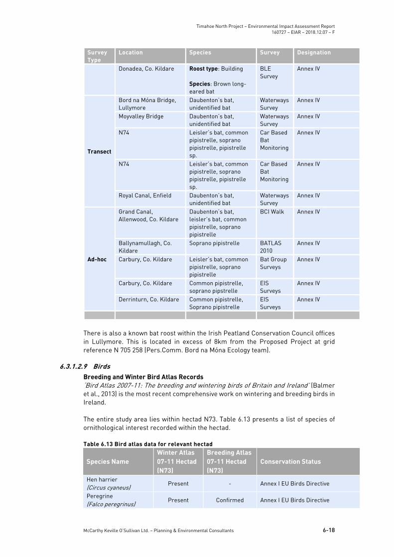
6.3.1.2.8 Bat Conservation Ireland Database The National Bat Database of Ireland was searched for records of bat activity and roosts within a 10 km radius of a center point within the Study Area (IG Ref: E275883, N235082). A number of observations have been recorded including roosts (n=21), transects (n=6) and ad-hoc observations (n=5). At least five of Ireland’s nine resident bat species were recorded within 10 km of the proposed works including common pipistrelle, soprano pipistrelle, Leisler’s bat, Daubenton’s bat and brown long-eared bat. The results of the database search are provided in Table 6.12. Table 6.12 BCI data within 10km radius of Study Area (IG Ref: E275883, N235082)
Survey Type
Location Species Survey Designation
Roost
Donadea, Co. Kildare Roost type: 12 No. Bat boxes Species: Leisler’s bat, pipistrelle sp., brown long-eared bat, unidentified bat.
Bat Box Scheme
Annex IV
Enfield, Co. Meath Roost type: Building Species: Leisler’s bat, pipistrelle sp.
EIS Surveys
Annex IV
Kilcock, Co. Kildare Roost type: Building Species: Pipistrelle sp.
Bats in Houses Project
Annex IV
Clonsast, Co. Kildare Roost type: Building Species:Brown long-eared bat
Bats in Churches Survey
Annex IV
Carbury, Co. Kildare Roost type: Building Species: Brown long-eared bat
Bat Group Surveys
Annex IV
Longwood, Co. Meath Roost type: Building Species: Pipistrelle sp.
Bats in Houses Project
Annex IV
Donadea, Co. Kildare Roost type: Building Species:Leisler’s bat, common pipistrelle
EIS Surveys
Annex IV
Summerhill, Co. Meath Roost type: Building
Species: Soprano pipistrelle
Bats in Houses Project
Annex IV
Carbury, Co. Meath Roost type: Building Species: Brown long-eared bat
EIS Surveys
Annex IV
Timahoe North Project – Environmental Impact Assessment Report 160727 – EIAR – 2018.12.07 – F
Donadea, Co. Kildare Roost type: Building Species: Brown long-eared bat
BLE Survey
Annex IV
Transect
Bord na Móna Bridge, Lullymore
Daubenton’s bat, unidentified bat
Waterways Survey
Annex IV
Moyvalley Bridge Daubenton’s bat, unidentified bat
Waterways Survey
Annex IV
N74 Leisler’s bat, common pipistrelle, soprano pipistrelle, pipistrelle sp.
Car Based Bat Monitoring
Annex IV
N74 Leisler’s bat, common pipistrelle, soprano pipistrelle, pipistrelle sp.
Car Based Bat Monitoring
Annex IV
Royal Canal, Enfield Daubenton’s bat, unidentified bat
Waterways Survey
Annex IV
Ad-hoc
Grand Canal, Allenwood, Co. Kildare
Daubenton’s bat, leisler’s bat, common pipistrelle, soprano pipistrelle
BCI Walk Annex IV
Ballynamullagh, Co. Kildare
Soprano pipistrelle BATLAS 2010
Annex IV
Carbury, Co. Kildare Leisler’s bat, common pipistrelle, soprano pipistrelle
Bat Group Surveys
Annex IV
Carbury, Co. Kildare Common pipistrelle, soprano pipstrelle
EIS Surveys
Annex IV
Derrinturn, Co. Kildare Common pipistrelle, Soprano pipistrelle
EIS Surveys
Annex IV
There is also a known bat roost within the Irish Peatland Conservation Council offices in Lullymore. This is located in excess of 8km from the Proposed Project at grid reference N 705 258 (Pers.Comm. Bord na Móna Ecology team).
6.3.1.2.9 Birds Breeding and Winter Bird Atlas Records ‘Bird Atlas 2007-11: The breeding and wintering birds of Britain and Ireland’ (Balmer et al., 2013) is the most recent comprehensive work on wintering and breeding birds in Ireland. The entire study area lies within hectad N73. Table 6.13 presents a list of species of ornithological interest recorded within the hectad. Table 6.13 Bird atlas data for relevant hectad
Species Name Winter Atlas 07-11 Hectad (N73)
Breeding Atlas 07-11 Hectad (N73)
Conservation Status
Hen harrier (Circus cyaneus)
Present - Annex I EU Birds Directive
Peregrine (Falco peregrinus)
Present Confirmed Annex I EU Birds Directive
Timahoe North Project – Environmental Impact Assessment Report 160727 – EIAR – 2018.12.07 – F
Present - Annex I EU Birds Directive, BOCCI Red Listed
Little egret (Egretta garzetta)
Present - Annex I EU Birds Directive
Lapwing (Vanellus vanellus)
Present Confirmed BOCCI Red Listed
Whinchat (Saxicola rubetra)
- Confirmed BOCCI Red Listed
Woodcock (Scolopax rusticola)
Present Probable BOCCI Red Listed
Curlew (Numenius arquata)
Present Confirmed BOCCI Red Listed
Yellowhammer (Emberiza citronella)
Present Probable BOCCI Red Listed
Meadow pipit (Anthus pratensis)
Present Confirmed BOCCI Red Listed
Twelve species listed in Annex I of the EU Birds Directive or on the BoCCI red list have been recorded within the ten kilometre square (hectad) in which the site is located during surveys for the most recent breeding and wintering bird atlases. Table 6.13 above, outlines those species recorded in the relevant hectad during the most recent breeding and winter bird atlas studies that are also protected under the EU Birds Directive or mentioned on the Birds of Conservation Concern in Ireland (BoCCI) red list. Biosphere Environmental Services (BES) Reports for Bord na Móna The results of bird surveys that were undertaken by Biosphere Environmental Services (BES) for Bord na Móna were reviewed. These surveys were undertaken over the 2012/2013 winter season and the 2014 breeding season at Derrygreenagh Ballydermot Bog complexes. Relevant data for Timahoe was extracted and is included in the full bird survey report that is included as Appendix 6-3. Each survey season was reported on and the findings from the surveys were discussed to conclude importance of the site for the species in question. The winter bird survey 2012-2013 report presents the following:
Lapwing was observed on two occasions, both instances were small flocks. Hen harrier was observed only once in a hunting flight during March 2013. Merlin was observed once in a hunting flight. Buzzard was observed once.
A tentative rating of Local Importance was assigned for wetland birds and hen harrier at the site. As per the 2013 breeding bird survey report, the following bird species of note were recorded:
Timahoe North Project – Environmental Impact Assessment Report 160727 – EIAR – 2018.12.07 – F
Lapwing – Two displaying pairs were recorded as present throughout the season.
Little egret – One bird was observed feeding in wetlands in June 2013. Buzzard – Seen regularly. Probable breeding nearby. Kestrel – Seen regularly. Probable breeding nearby.
A tentative rating of County Importance was assigned for Breeding Wetland Birds at the site. However, it should be noted that the breeding wetland birds include Snipe which is an abundant species and may distort the rating of County Importance for Wetland Birds, as the only other waders breeding at the site was Lapwing. The winter bird survey 2013-2014 report presents the following:
Lapwing was observed on four occasions, two observations were small flocks flying over the site, while the other two observations were displaying birds during a single survey on March 12th 2014.
Hen harrier was observed on three occasions in hunting/travelling flights. Peregrine was observed twice flying over the site. Golden plover was observed on six occasions, each observation was of a small
flock of birds. Whooper swan was observed on four occasions, each time in a flock of less
than five birds. Woodcock was observed displaying (roding) on four occasions during a survey
on March 12th 2014. Sparrowhawk was observed in most months. A pair were observed displaying
in February. Kestrel was observed in most months. A pair were observed in March. Buzzard was recorded throughout the season. A pair were observed displaying
in February and March 2014 over the Northern part of the site.
A tentative rating of Local Importance was assigned for Wetland Birds and Hen Harrier at the site. The summer bird survey 2014 report presents the following:
Lapwing – Three displaying pairs were recorded on the 24th of April but were not recorded in May. Regular presence of Hooded Crows may have caused the birds to abandon nesting attempts in the area.
Water rail - Up to four birds calling in late April. Woodcock – One bird was observed displaying in April. Meadow pipit – Estimated to be at least 20 breeding pairs on site. Buzzard – Seen regularly. Probable breeding nearby.
A tentative rating of County Importance was assigned for Breeding Wetland Birds at the site. However, it should be noted that the breeding wetland birds include Snipe which is an abundant species and may distort the rating of County Importance for Wetland Birds, as the only other waders breeding at the site was Lapwing (included even though no birds successfully bred). Irish Wetland Bird Survey (IWeBS) Records The site is not within a significant distance of any IWeBS site (<15km). The nearest IWeBs site is located approximately 30km from the site.
Timahoe North Project – Environmental Impact Assessment Report 160727 – EIAR – 2018.12.07 – F
Identification of potential waterfowl habitat outside the study area A search for suitable waterfowl roost habitat outside the site but within a one kilometre radius of it was undertaken. This used ortho-base maps and ordnance survey maps of the study area as well as an initial survey on the 28th of November 2017. No sites (e.g. ponds, rivers, lakes, reservoirs) were deemed suitable to support wintering and migratory bird species within a one kilometre radius of the study area, nor were there any waterfowl or wader species observed during the survey in November.
6.3.1.2.10 EPA Water Quality Data The Biotic Index of Water Quality (BIWQ) was developed in Ireland by the Environmental Protection Agency (EPA). Q-values are assigned using a combination of habitat characteristics and structure of the macro-invertebrate community within the waterbody. Individual macro-invertebrate families are classified according to their sensitivity to organic pollution and the Q-value is assessed based primarily on their relative abundance within a sample. The site is situated within the Boyne river catchment in the eastern river basin district. There is a highly modified watercourse on site, flowing in a south easterly direction and ultimately discharging to the River Blackwater 7km downstream. An additional watercourse, the Fear English river lies outside the north-western boundary of the site, flowing in a north easterly direction and discharging to the River Blackwater. River Basin Management Plans (RBMPs) have been published for all River Basin Districts in Ireland in accordance with the requirements of the Water Framework Directive. The online EPA Envision map viewer provides access to water quality information at individual waterbody status for all the River Basin Districts in Ireland. The EPA Envision map viewer was consulted on 11th October 2018 regarding the water quality status of the rivers which run within and directly adjacent to the Study Area. The WFD River Waterbody Status 2010-2015 for the watercourse which flows through the site has been assessed as having “poor” quality status. The Fear English river has been assessed as having “moderate” quality status. Both watercourses are classified as ‘at risk’, according to the WFD River Waterbody risk score. There are no Environmental Protection Agency (EPA) Q-value monitoring sites within the proposal boundary or immediately downstream. Sample station RS07B020060 (Br S of Hortland) is located approximately 8.5km downstream of the proposal on the River Blackwater. The latest Q-Value at this location has been recorded in 2015 as ”Q3 - Poor”.
6.3.1.2.11 Inland Fisheries Ireland Online Database The River Blackwater is a tributary of the River Boyne. A search of the Inland Fisheries Ireland (IFI) online database indicates that the River Boyne, contains brown trout (Salmo trutta), Lamprey (Lampetra sp.), Minnow (Phoxinus phoxinus), Stone loach (Barbatula barbatula), Three-spined stickleback (Gasterosteus aculeatus) and European eel (Anguilla anguilla), from IFI surveys carried out in 2009 at Boyne Bridge (IFI, 2018). European eel (Anguilla Anguilla), is classified as ‘critically endangered’ in ‘Ireland Red List No. 5: Amphibians, Reptiles & Freshwater Fish’ (King et al., 2011). Lamprey (Lampetra sp.) are classified as ‘near threatened’ in ‘Ireland Red List No. 5: Amphibians, Reptiles & Freshwater Fish’ (King et al., 2011) and all three species of Irelands lamprey are protected under Annex II of the EU habitats directive, with River Lamprey classified under Annex II and Annex V.
6.3.1.3 Information on Small Skipper Butterfly The bulletin of the Irish Biogeographical Society No.37 (2013) was reviewed and is provided as Appendix 6-4 This document confirms the presence of the Small Skipper butterfly at Timahoe North.
Timahoe North Project – Environmental Impact Assessment Report 160727 – EIAR – 2018.12.07 – F
The Small Skipper butterfly was recorded on Timahoe Bog in 2011. This finding was confirmed in 2012 when approximately 30 were observed both north and south of the road between Drehid Cross and Timahoe Cross at Drumachon (Grid Ref: N748330). The locations of the recorded butterflies are provided in Figure 6.2 of this report. The species was also recorded in 2013. The butterflies were recorded along the old railway track in rank grassland habitat that is widespread in the wider area and alongside road verges outside the bog and along train tracks within it. It was recorded where there was a number of forb species present including knapweed (Centaurea nigra), Great Willowherb (Epilobium hirsutum) and red clover (Trifolium pretense).
6.3.1.4 Previously Completed Ecological Assessments of Timahoe North Bog A review of a number of previous ecological assessments of Timahoe Bog were reviewed in the preparation of this EIAR. These assessments provide much of the baseline ecological information that informs this biodiversity chapter. The various assessments reviewed are summarized below.
6.3.1.4.1 Bog of Allen Habitat & Heritage Survey, IPCC In 2005 the Irish Peatland Conservation Council (IPCC) completed a survey of the entire Bog of Allen, which is a complex of raised bogs with six main raised bog masses. Timahoe Cutaway (where the project is proposed) is among the bogs that were included in this survey. The survey identifies the area as supporting the following communities:
Cutover Bog (PB4) – Bog Cotton community Wet Heath (HH3) Bog Woodland (WN7) Scrub (WS1) Dystrophic Lake (FL1) Conifer Plantation (WD4)
The study identifies the conservation value of the cutover and regenerating peatlands along with the value of the woodlands, scrub and lakes as habitat for bird species. It recommends the removal of coniferous trees that are invading on the cutaway, the encouragement of wildlife habitats as part of the after use plan and the planting of native trees to develop woodland trails. Whilst the Timahoe North Bog has been cut away in the past (and all of the areas where the project is proposed), it was identified in this survey as having a conservation value and recommends that it should be designated for wildlife and amenity. It was the only cutaway bog that was considered to be of Regional Importance in the survey. The survey also describes a number of areas of uncut bog that form part of the Timahoe North Bog but are not on the cutaway and are not part of the site of the Proposed Project. These include Mulgeeth Bog, Hortland Bog and Drumachon Bog. The Proposed Project does come within approximately 50 metres of these uncut sections of bog in places. The relevant sections of the IPCC survey are included as Appendix 6-5.
6.3.1.4.2 County Kildare Wetland Survey Kildare County Council commissioned a survey of wetlands within the County. A report on the County Kildare Wetland Survey was produced in 2014, with the relevant extract of the report provided in Appendix 6-7 of this EIAR. Timahoe North was among the wetlands surveyed within the County.
The summary site description from that survey is provided below:
The majority of the site has either re-vegetated with pioneer heather dominated dry heath or with birch scrub/bog woodland in various stages of development. Some hollows areas contain open water with associated wetland vegetation around them and there is some more extensive open water with wetlands developing along the southern railway embankment. A number of rare and protected habitats, flora and fauna have been recorded from the hectads in which the Proposed Project is located. The field surveys were thus designed to identify habitats, flora and fauna, or additional ecological receptors occurring within the study area.
The following habitats were identified on the site during this survey:
BL3 Buildings and artificial surfaces FL8 Other artificial lakes and ponds FW4 Drainage ditches PB1 Raised bogs PB4 Cutover bog PF2 Poor fen and flush WN7 Bog woodland WS1 Scrub
This survey ranked Timahoe North Bog as being of National importance and recommended the development of a re-instatement programme focusing on the biodiversity value of the area and adjacent intact high bogs. (nb: the survey included areas of uncut bog within the area and these areas are not within the Proposed Project site).
6.3.1.4.3 Bord na Móna Ecological Survey and Draft Rehabilitation Plan Bord na Móna produced a draft rehabilitation plan for the site as required under Condition 10 of the IPC licence. This is updated every two years and was last updated in 2017. This included ecological surveys and habitat mapping undertaken by the Bord Na Móna Ecology Team between 2010 and 2016. These surveys provided the baseline habitat information that was used in the current assessment. The habitat assessment and mapping that was produced as part of this Bord na Móna survey was reviewed and used to inform the field surveys that were undertaken. Where necessary, following the site surveys and following discussions with the Bord na Móna Ecology Team, the habitat map was updated to reflect the current situation on the site. The key biodiversity features of interest as set out in the draft rehabilitation plan are listed below:
This site is relatively unique when compared to other Bord na Móna cutaway
sites in that industrial peat production has ceased and it has been cutaway for a relatively long period of time. This has allowed the development of large areas of Birch and Pine scrub/woodland in mosaic with dry heath and poor fen vegetation communities that are somewhat better developed and more diverse than seen at other comparable sites. The majority of the site has revegetated to some degree (apart from those areas where there is still sod-peat cutting licenced by Bord Na Móna).
The former history of the site as a sod peat production area has meant that there is still significant volume of more acidic bog peat left on site, compared to milled cutaway sites where fen peat is left. This is allowing the development of some embryonic raised bog and Sphagnum-rich poor fen communities in places as
Timahoe North Project – Environmental Impact Assessment Report 160727 – EIAR – 2018.12.07 – F
well as extensive development of other more acidic communities like dry heath. This feature marks out this site as being somewhat unusual and also having relatively more biodiversity value compared to other (more typical midland poor fen) cutaway sites due to such a large site developing these types of communities.
There is also a small amount of open water and wetland habitat on site that may be increasing in extent recently due to drains being recently impeded.
A small area of high bog occurs outside the south of the proposal (at Drumachon). This bog remnant has been burnt in the recent past but still retains typical raised bog characteristics (that qualifies as the Annex I EU Habitats Directive habitat – ‘degraded raised bogs still capable of regeneration’ – 7120). (Note: Number codes refer to EU habitat classification system – European Commission 1996). The bog also contains a small wet area of ‘active’ raised bog, which qualifies as the Annex I EU Habitats Directive habitat – ‘active raised bog’ (7110). This bog remnant was noted in the IPCC Bog of Allen survey (Hurley 2005) as having regional ecological value. This bog remnant was also assessed as part of the Kildare Wetland Survey (Foss & Crushell 2014). Currently turf-cutting, on both Bord Na Móna and third party lands is ongoing around this high bog area and cutting into the surrounding drained area of the bog remnant.
The site is a significant refuge for wildlife. Species of conservation interest that were noted in the area included snipe, buzzard and cuckoo. Breeding birds also include Snipe, Lapwing and Teal (Biosphere Environmental Services 2014). Occasional small flocks of golden plover and lapwing use the site during winter as do peregrine and hen harrier.
Small Skipper Butterfly. Timahoe North was one of the first sites in Ireland where this recent butterfly colonist has been recorded. Based on records outlined in Section 6.3.1.3 of this report, the species is known to be present along the grassy old railway areas.
The draft rehabilitation plan is included in full in Appendix 6-6.
6.3.2 Field Assessment
6.3.2.1 Description of habitats The habitats on the site of the Proposed Project were the subject of a detailed survey and assessment by Bord na Móna ecologists and a habitat map was produced of the entire landholding at Timahoe North Bog. This habitat mapping and assessment was undertaken following the Bord na Móna habitat classification scheme and was cross referenced with ‘A Guide to Habitats in Ireland’ (Fossitt, 2000). The Proposed Project covers only a section of the overall Timahoe North Bog but the habitats on the entire Timahoe North Bog are described in this section. Habitat maps (Figures 6.3a and 6.3b) have been created to show the location and relative cover of the habitats recorded within the study area. Figures 6.3a and 6.3b show the habitats on the site with the Proposed Project footprint overlain. The entire study area comprises a large cutover raised bog with remnant uncut bog at various locations at its edges. This bog has been out of commercial peat production by Bord na Móna for at least 20 years and vegetation has regenerated over much of the area. There is still third party sod peat extraction being undertaken in some sections
of the site. The main habitat types on the site were identified and classified by Bord na Móna ecologists and included woodlands and scrub, secondary dry heath communities, poor fen and bare peat with some open water communities and grasslands (alongside railway tracks). There were also some remnant areas of uncut raised bog within the study area. These habitats occur in intimate mosaics throughout the study area as is shown in Figure 6.3b. The habitat descriptions below are based on the Bord na Móna habitat assessments and the ground truthing surveys that were undertaken by McCarthy Keville O’Sullivan. Bog Woodland/Scrub (WN7/WS1) The habitats on the site have developed as birch dominated scrub and woodland in the areas where the peat production has ceased for the longest periods and where the cutaway is relatively dry. A mosaic of these habitats dominates large sections of the study area. The woodlands and scrub are often well developed alongside the drains that run throughout the site in a north east – south west axis. The woodlands and scrub have in many areas colonized outward from the drains and act as boundaries to the old peat cutting fields. They provide separation, cover and shelter throughout the site. In general, the woodlands and scrub are relatively recently colonized and have a poorly developed layer structure and ground flora. Typically, they are dominated by birch (Betula pubescens) with willows (Salix spp.) and Scot’s and Lodgepole Pines (Pinus sylvestris & P. contorta). Hawthorn (Crataegus monogyna), elder (Sambucus nigra). The ground flora was commonly dominated by brambles (Rubus fruiticosus agg.) with bracken (Pteridium aquilinum) and other fern species, as the dominant component of the ground flora. In areas where the woodlands and scrub were colonizing the cutover bog, the ground flora was often dominated by ling heather and in places purple moor grass (Molinia caerulea). There is both scrub and woodland present on the site. Where scrub was greater than 4 metres in height, it was classified as Bog Woodland (as per Fossitt, 2000). The Annex I Bog Woodland habitat (91DO) was not recorded on the site during the Bord na Móna habitat surveys or the ground truthing exercise that was undertaken by McCarthy Keville O’Sullivan. None of the woodland areas had developed on Sphagnum rich substrates. However, a small spring fed wetland area within the site supported a dense carpet of bryophytes including abundant Sphagnum species along with the mosses Campylium stellatum and Ctenidium molluscum. The outer edge of the wetland area supports low growing birch scrub at present. This area has been deliberately excluded from the Proposed Project footprint. Plate 6.1 shows a typical section of birch dominated bog woodland from the study area with small trees, low structural diversity and dry ground and dominant bramble. Plate 6.2 shows the woodlands and scrub forming the boundaries to the old peat cutting fields and how it forms a mosaic with heath and cutover bog habitats.
Timahoe North Project – Environmental Impact Assessment Report 160727 – EIAR – 2018.12.07 – F
Plate 6.1. Typical Bog Woodland found throughout the study area
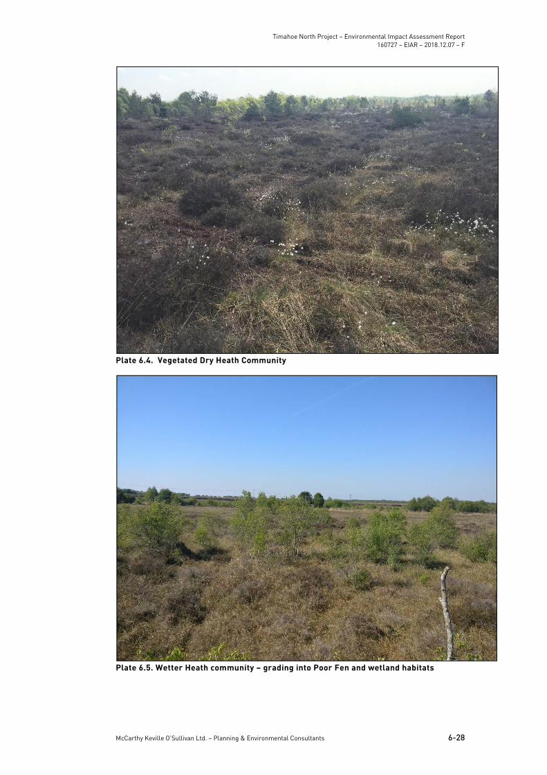
Plate 6.2. Woodlands and Scrub around drains at the edge of the peat cutting fields Pioneer Stage Dry Heath Habitats(HH1) The secondary dry heath communities were often dominated by tall ling heather with some purple moor grass and cottongrasses on dry peats with little or no Sphagnum
Timahoe North Project – Environmental Impact Assessment Report 160727 – EIAR – 2018.12.07 – F
present. Some of this vegetation is also analogous to Raised Bog – Facebank Ecotope. These habitats contained varying amounts of bare peat and formed intimate mosaics with wetter poor fen communities and woodlands/scrub. It is likely that the dry heath areas would, if left undisturbed, colonize to form bog woodland (BnM – Dry Birch Woodland – Non Annex I). The wetter heath communities supported higher abundance of Sphagnum, purple moor grasses and bog cottons. These areas graded freely into poor fen and wetland communities. This habitat type covers a broad range of conditions from bare peat (Plate 6.3) and dry but vegetated (Plate 6.4) to much wetter areas that grade into poor fen (Plate 6.4). In grassy sections of the heath habitat, there were orchids present including heath spotted orchid (Dactylorhiza maculata), twayblade (Listera ovata) and marsh helleborine (Epipactis palustris)
Plate 6.3. Dry Heath with bare Peat
Timahoe North Project – Environmental Impact Assessment Report 160727 – EIAR – 2018.12.07 – F
Cutover Bog (PB4) Large sections of the study area are in active production of sod peat by third party operators or have recently ceased to be in active production. These areas are dominated by bare peat with little growth of vegetation.
Plate 6.6. Cutover bog vegetation Poor Fen (PF2)/Reedswamp (FS1) Many sections of the study area supported cutaway bog that was dominated by common bog cotton and could be very wet underfoot (though with little open water except after prolonged wet weather) or dry. Other species frequently recorded included purple moor grass, soft rush (Juncus effuses) and hummocks of the moss Polytrichum commune. This habitat was quite variable but was widespread within the study area. It formed mosaics with heath and woodland habitats and was classified by Bord na Móna as Poor Fen (Plate 6.7). Bord na Móna recognised the potential for the vegetation communities to develop into embryonic bog habitat in the future due to the presence of species such as Sphagnum subnitens, S.capillifolium and White Beaked Sedge (Rynchospora alba), which are untypical of Poor Fen that develops on cutaway and prefer more acidic conditions associated with the deep peats that persist on the site. The abundance of these species varies from occasional to abundant throughout the site. There are also small areas with Poor Fen vegetation associated with open water pools within the study area. These areas are once again dominated by common cotton grass but also contain species such as bottle sedge (Carex rostrata), jointed rush, reedmace (Typha latifolia) and common reed (Phragmites australis). There were some very wet examples of Poor Fen with dense carpets of Sphagnum and hares tail cotton grass in various locations within the study area (Plate 6.8).
Timahoe North Project – Environmental Impact Assessment Report 160727 – EIAR – 2018.12.07 – F
In addition, there were some areas of open water within the study area, though these were scarce throughout the site and in general were in mosaics with Poor Fen and Reedbeds (Plate 6.9). In one area, a spring fed wetland has developed a Poor Fen with more alkaline influences. This area is dominated by bottle sedge with cotton grasses at its edges and mosses that are indicators of Alkaline Fen habitats (PF1). This area has been deliberately avoided in the design of the Proposed Project.
Plate 6.7. Dry variant of Poor Fen within the study area
Timahoe North Project – Environmental Impact Assessment Report 160727 – EIAR – 2018.12.07 – F
The grasslands that are present within the study area are primarily limited in their extent to the sides of old trackways and railway lines. Many of the verge areas are classified as Dry Meadows and Grassy Verges with rank grasses including false oat grass (Arrhenatherum elatius), Yorkshire fog (Holcus lanatus), cocks foot (Dactylis glomerata) and encroaching scrub with nettle (Urtica dioica), bramble and rosebay (Epilobium angustifolium). Other areas are less rank and support more calcareous grasslands with species such as knapweed (Centaurea nigra), sweet vernal grass (Anthoxanthum odoratum), lady’s bedstraw (Galium verum), dandelion (Taraxicum officinalis agg.) and bird’s foot trefoil (Lotus corniculatus). Many of the tracks and grasslands were surrounded by willow scrub and woodlands making them sheltered.
Plate 6.10. Rank grasslands surrounding the track in the centre of the study area Drainage Channels (FW4) The study area is extensively drained with deep channels that run in a north west – south east axis and are largely parallel to one another. The vast majority of the study area drains towards a single outfall point on the south eastern boundary. The majority of the ditches are surrounded by dense woodlands and many have ceased to function effectively as a result of a lack of maintenance since peat production has finished. In the areas where the drains are surrounded by dense woodland and scrub, the vegetation within them is sparse and the substrate comprises of bare silt (Plate 6.11). In the areas where there is less cover of trees, many of the drains support dense macrophytes including reedmace, horsetails (Equisetum spp.) and common reed (Phragmites australis) (Plate 6.12). In other areas the drains are large and hold deep water with floating vegetation such as Pondweeds (Potamogeton spp.) but none were recorded flowing (Plate 6.13).
Timahoe North Project – Environmental Impact Assessment Report 160727 – EIAR – 2018.12.07 – F
Plate 6.13. Deep drain within the study area Uncut Raised Bog (PB1) Uncut raised bog communities are present as remnants of the former habitat at the southern and northern sections of the study area. These areas are located around the edge of the Timahoe cutaway and are identified as Drumachon Bog, which is located to the north of the proposed access route to the Proposed Project and Mulgeeth Bog, which is located at the very northern extent of the study area and outside the Proposed Project area. These areas still support Sphagnum rich Raised Bog communities with abundant ling (Calluna vulgaris), bell heather (Erica tetralix), cotton grasses (Eriophorum angustifolium & E. vaginatum). These areas have been deliberately avoided in the design of the Proposed Project.
6.3.2.2 Botanical Species Present Species listed in Annex II of the EU Habitats Directive or additional flora listed in the Flora (Protection) Order (2015) or red list of vascular plants (Jackson et. al 2016) were not recorded. None of the protected and rare species noted from the desk study were recorded during the extensive surveys undertaken with the exception of alder buckthorn (Frangula alnus) and bog sedge (Carex limosa), which were identified by Bord na Móna ecologists during their detailed surveys of the site.
6.3.2.3 Invasive Alien Plant Species During field surveys, a search for Invasive Alien Species (IAS) listed under the Third Schedule of the European Communities Regulations 2011 (S.I. 477 of 2015) was conducted. No invasive species were recorded during the field surveys undertaken.
6.3.2.4 Significance of Habitats and Flora Ecological evaluation within this section follows a methodology that is set out in Chapter 3 of the ‘Guidelines for Assessment of Ecological Impacts of National Roads Schemes’ (NRA, 2009).
Timahoe North Project – Environmental Impact Assessment Report 160727 – EIAR – 2018.12.07 – F
The habitats of highest ecological significance within the study are those that are most closely associated with the Raised Bog habitat that would have dominated the entire site in advance of the peat cutting operations. As such, the remnant Raised Bog habitat at Drumachon and Mulgeeth Bog have been assigned National Significance as they contain the only remaining examples of Raised Bog habitat in an area that was previously dominated by this EU Habitats Directive Annex I Habitat. The high bogs were found in the Bord na Móna surveys to correspond to the Annex I habitat – ‘Degraded Raised Bogs capable of regeneration (7120)’ with some areas in Drumachon supporting the Annex I Habitat – ‘Active Raised Bog (7110)’ These areas are subject to drying out, drainage and encroachment of trees but are nonetheless of high ecological significance. The secondary habitats recorded on the cutaway sections of the site vary in their ecological significance with large areas of broadleaved woodland and scrub present along with a diverse mosaic of Dry Heath, and Poor Fen with some open water habitats. It is noted that some of the Sphagnum rich Poor Fen habitats have the potential to form embryonic bog communities. These are however, a very small component in the overall area. The habitats listed above are assigned County importance. This is on the basis that they consist of a large area of semi-natural habitats with a high biodiversity value in the context of County Kildare. The Cutover Bog and bare peat habitats are of low ecological significance in their current state and have been assigned Local Importance (Lower Value). However, it is noted that if turf cutting ceased, these habitats would inevitably revegetate in a similar manner to the rest of the site. The value of the site as a peatland is also considered. This bog was not cutaway to the base of the peat and still retains a significant depth of more acidic bog peat throughout, rather than the less acidic fen peat that is more typical on a cutaway site. This has been acknowledged in the Bord na Móna ecological assessment of the site and the development of Sphagnum rich habitats that are not regularly found on Bord na Móna midlands cutaway peatlands. Overall, as a complex of habitats and excluding the areas of high bog that are of national importance, the Timahoe North Bog is assigned Regional or County importance for the reasons described above.
6.3.3 Fauna in the Existing Environment
6.3.3.1 Birds A full bird survey report is provided in Appendix 6-3. The following provides a synopsis of the combined findings of the surveys undertaken during the 2016/2017 winter season (November 2016 – March 2017) and the 2017 breeding season (April 2017 – June 2017) for each of the target species recorded and in relation to the wildfowl on the site. Whooper Swan During the 2016/2017 winter season surveys whooper swan were only observed on five occasions. All observations occurred on the 29/11/2016 within 80 minutes of one and other at transect 5. There were no other observations of this species on or near the site during any other surveys undertaken. There is very little suitable wintering habitat for this species on or near the site. It is likely that all observations were just commuting through the site. Flocks were recorded in low numbers. This species is not of any major concern to the site at present. In addition, this species was not observed in any significance during either the 2012/2013 or 2013/2014 winter periods. This site is of no importance for whooper swan.
Timahoe North Project – Environmental Impact Assessment Report 160727 – EIAR – 2018.12.07 – F
This species breeds in Iceland during the summer months and was therefore not expected to be observed during breeding walkover surveys, nor was it seen. Golden Plover This species was observed on six occasions during the 2016/17 winter survey period. All observations were of individual birds or very small flocks with numbers ranging from one to a flock of 80 birds. During the 2017 breeding season this species was only observed on three occasions. All three observations were of small flocks recorded in early April with no breeding activity observed. It is very likely that all observations in early April were just late migrating birds. There is very little suitable breeding or wintering habitat for this species on or near the site. It is likely that all observations were just commuting through the site. Flocks were recorded in low numbers, the site is of low significance to the species. This is re-enforced by results of previous surveys by BES where golden plover were not observed in any real significant numbers throughout the two years of surveys. This site is of low significance for golden plover. Lapwing During the entire winter season lapwing were only observed once. Observation was of an individual alarm calling in flight on the 28/11/2016.
While during the 2017 breeding season this species was observed on four occasions. Observations in April and May consisted of birds observed in the same general area, although not displaying any breeding activity. Two observations occurred in June within this same area, with individuals in displaying flights on this occasion. While no nest or fledged chicks were observed throughout the surveys, this area has been treated as a potential breeding territory, see Figure 2.3.1, Appendix 1-3 of the Breeding Bird Survey Report (provided in Appendix 6-3 of the EIAR). These results are in line with the findings from the BES survey reports, where no significant flocks were observed during any of the winter seasons, and there was a low amount of breeding activity with just a few displaying birds observed in any of the breeding seasons, but no nests or fledged chicks were recorded during any of the summer surveys. The site is of low significance for lapwing. Wigeon This species was recorded only twice during the entire winter survey period. Both observations occurred on the 28/11/2016 at Transect 1, within seven minutes of each other. There were no observations of this species throughout the entire breeding season. Wigeon were not recorded at all during any of the previous surveys at the site by BES. This highlights that the site is of low importance for Wigeon and that the observation during November 2016 was just a small flock passing through the site on way to wintering grounds elsewhere. Woodcock During the entire winter season Woodcock was only observed once. Observation was of an individual calling on the 29/11/2016. There were no observations of this species at all during breeding walkover surveys.
Timahoe North Project – Environmental Impact Assessment Report 160727 – EIAR – 2018.12.07 – F
These results are in accordance with results from previous surveys by BES as there was only one reported observation of Woodcock throughout the two-year period. Observation was a displaying bird in April 2014. Woodcock is only designated as a red listed BOCCI species for the breeding season. Buzzard The range and population of this species has increased considerably in Ireland in recent years and it is now a common resident in many areas including around the survey site. During the 2016/2017 winter season surveys buzzard were observed on just three occasions throughout the entire survey period, all of which were individuals flying in a hunting or travelling flight. There were no other observations of this species on or near the site during breeding walkover surveys. Previous surveys from BES assigned buzzard a probable breeding status within proximity of the site during both the 2013 and 2014 breeding season. Although no confirmed breeding activity is mentioned in the reports.
This species is green listed BOCCI status and had a very low recorded presence on site. The site is of low significance for this species. Kestrel This species was observed only twice throughout the entire winter survey period, both of which were individuals. In addition, this species was only observed once during breeding walkover surveys. Observation was an individual bird in a hunting flight. Previous surveys from BES assigned kestrel a probable breeding status within proximity of the site during 2013 breeding season, although no confirmed breeding activity is mentioned in the reports, just regular observations. However, there were no reported records of kestrel during the following 2014 breeding season. Based on the nature of the habitats within the site and the records for the species, the species is not dependent on the site, with suitable habitat occurring in the wider area. Sparrowhawk This species was not observed throughout the entire winter survey period. During the 2017 breeding season this species was only observed once, in a hunting flight. Previous surveys by BES indicate similar findings, with this species only recorded during the 2013/2014 winter period, highlighting that the species does not regularly utilize this site. This is a common and widespread species in Ireland and these low levels of activity are not significant. Meadow Pipit This species was observed numerously throughout both winter walkover and breeding walkover surveys. Forty-five breeding territories were identified for this species within the site. Surveys by BES during the 2014 breeding season estimated approximately twenty breeding pairs on site. This shows a marked increase in breeding population since then with the numbers more than doubled in the 2017 findings.
Timahoe North Project – Environmental Impact Assessment Report 160727 – EIAR – 2018.12.07 – F
While this species is red listed on the Birds of Conservation Concern Ireland for breeding birds, it is one of the most common bird species in Ireland and recent data shows that the species has recovered from the hard winters of 7-8 years ago. Due to the now widespread and abundant population of Meadow Pipit, it is not envisaged that the site is of particular significance for the species. Snipe This species was observed numerously throughout both winter walkover and breeding walkover surveys. Nine breeding territories were identified for this species within the site. Surveys by BES during both the 2013 and the 2014 breeding seasons estimated approximately six breeding pairs on site in both years. This shows a marked increase in breeding population since then with the numbers of breeding pairs up 50% in the 2017 findings. Snipe is a common and abundant species throughout Ireland but has been assigned a tentative rating of County Importance for the Timahoe site. However, as seen in Figure 2.3.1, Appendix 1-3 of the Breeding Bird Survey Report (provided in Appendix 6-3 of the EIAR), Snipe along with other wetland birds do not utilise the Proposed Project site to a large extent for breeding, instead they are predominately found in the more suitable wetter areas to the South. Additional Wetland Bird Species Due to suitable wetland habitat in the surrounding areas of the site a number of other species of less significance were observed. Details of these species can be found in Appendix 6-3, along with their conservation status as justification of omission from the target species list. The species observed during surveys included Grey Heron, Little Grebe, Mallard, Moorhen and Teal. None of these species were observed in any great abundance during either breeding or winter walkover surveys. Breeding territories for all of the above species can be seen in Figure 2.3.1, Appendix 1-3 of the Breeding Bird Survey Report (provided in Appendix 6-3 of the EIAR), with the exception of Grey Heron which was only observed once during breeding walkover surveys, flying over the site. Breeding territories are almost exclusively south of the Proposed Project area in the more suitable wetland habitat. The Proposed Project site provides lower quality habitat for these species and as such, they are more likely to be found in the surrounding wetland areas to the south.
6.3.3.2 Bats Bat surveys were undertaken within the site and the surrounding area in 2017. The full bat survey report is provided in Appendix 6-2. The following paragraphs provide a summary and discussion of the survey results. Habitat Suitability Foraging & Commuting Habitats within the Study Area are dominated by scrub and re-vegetating cutover bog. The remainder includes cutover bog, drainage ditches and some areas of standing water. The site is well connected to the wider landscape through hedgerows, treelines and conifer edge habitats bordering the site.
Timahoe North Project – Environmental Impact Assessment Report 160727 – EIAR – 2018.12.07 – F
A habitat suitability assessment for foraging and commuting bats was carried out in 2017.
Scrub (particularly linear features) and vegetated drainage ditches were assessed as Moderate suitability
Areas of cutover bog were considered Negligible suitability The results of bat activity surveys confirmed a preference for railway lines and access tracks with scrub and avoidance of open areas of cutover bog. These results are consistent with the findings of INIS and MWP in 2013 and 2016. Roosts A search for roosts was undertaken within the Study Area in 2017, using a four-season approach.
There were no suitable structures for roosting within the Study Area. Trees were not of sufficient type, size or age for roosting bats.
Habitat assessments and roost surveys undertaken in 2013, 2016 and 2017 did not find any suitable roosting sites for bats within the Study Area. This included no suitable sites for maternity colonies, swarming activity or hibernation. Species Composition & Activity Levels Manual transects and static detector surveys were undertaken in April and July 2017. Throughout these surveys, bat activity was assessed as low. The majority of activity encountered during transects and static detector surveys in 2017 was attributed to soprano pipistrelle followed by common pipistrelle. These species are common and widespread across Ireland. Other species, including Leisler’s bat, Myotis sp. and brown long-eared bat, were recorded in much lower numbers. Species composition and activity levels in 2017 were consistent with previous baseline surveys undertaken by INIS and MWP. No large populations of bats were encountered and no bat roosts were recorded. Most activity recorded was attributed to foraging pipistrelle bats, followed by commuting bats and a few social passes. Seasonality MWP undertook transect surveys during autumn 2016. These surveys were replicated by MKO in spring and summer 2017. Figure 6.4 illustrates these combined transect survey results. Bat activity peaked in autumn 2016, was lowest in spring 2017 and increased in summer 2017. This is consistent with typical Irish bat ecology. In general, activity is low in spring as bats emerge from hibernation and temperatures are still relatively low. Activity increases throughout the summer as food is abundant and breeding is underway. Activity then often peaks in late summer or autumn as young bats are also on the wing.
Timahoe North Project – Environmental Impact Assessment Report 160727 – EIAR – 2018.12.07 – F
Figure 6.4: Transect survey results 2016 & 2017: Seasonality in bat activity
6.3.3.3 Non-volant Mammals The following paragraphs describe the results of the mammal surveys that were undertaken both as dedicated surveys and during the ecological walkover surveys. Figure 6.5 provides an overview of mammal tracks, signs or sightings recorded during the survey period, with the exception of badger sett locations. All badger sett locations are provided in Figure 6.6, Confidential Appendix 5-8. During the walkover survey, signs of the following mammal species were recorded:
Fox (Vulpes Vulpes) scat was recorded at various locations throughout the study area. However, no dens or other signs of the species were recorded during the survey and no dedicated survey for the species was required.
Hare (Lepus timidus hibernicus) was frequently recorded throughout the study area along with its droppings and footprints. The species is widespread throughout the habitats present and no dedicated survey for the species was required.
Scat that was likely to be that of pine marten (Martes martes) was recorded infrequently throughout the site. The scats were primarily located on fallen trees throughout the site, which is typical of the species. No dens were recorded and no requirement for dedicated survey was identified.
Deer prints were recorded infrequently throughout the site. These are likely to be Fallow Deer (Dama dama). This is an invasive species listed on the Third Schedule of the Birds & Natural Habitats Regulations. No dedicated survey for this species was considered necessary on the basis that this is an invasive species.
Red Squirrel (Sciurus vulgaris) was recorded within woodland to the north of the site and dedicated surveys for the species were then undertaken during subsequent walkover surveys. No further squirrels, dreys or obvious feeding signs were recorded during the surveys undertaken. No evidence that the study area supports a high population was recorded.
Badger (Meles meles) signs were recorded throughout the site in the form of latrines, feeding signs, prints, hair on wire fences and paths. These were concentrated in the southern and western sections of the site. Following, the
recording of Badger activity on the site, a dedicated badger survey was undertaken and four confirmed Badger sSetts were identified. Two were active setts with piles of fresh bedding outside them. Two further setts were inactive and overgrown. Another single hole was identified and was likely to be a badger sett. It was inactive at the time of the survey. Plate 6.14 shows one of the active badger setts recorded within the study area.
Plate 6.14. Multi entranced active Badger sett In addition to the above mammal species that were recorded (or signs thereof), it is likely that other species also occur on or around the site but were not recorded during the site surveys that were undertaken. These include small mammal species such as pygmy shrew (Sorex minutus) and wood mouse (Apodemus sylvaticus) but also larger mammals such as Stoat (Mustela ermina) and mink (Mustela vison). No signs of any of these species were recorded during the walkover surveys and no requirement for dedicated surveys was identified. Otter (Lutra lutra) is considered likely to utilise the drains within the study area to some extent but no signs of the species were recorded despite dedicated searches of drains throughout.
6.3.3.4 Reptiles and Amphibians Common frog (Rana temporaria) was recorded in wet areas within the site (including in drains and pools and in bog habitats). The species is likely to breed within the study area. Common lizard (Zootoca vivipara) and smooth newt (Lissotriton vulgaris) were also recorded within the site and are likely to be widespread in the heathland habitats. The Proposed Project will not result in a significant loss of suitable habitat for reptiles, amphibians or invertebrates. Suitable habitat is widespread in the study area and
Timahoe North Project – Environmental Impact Assessment Report 160727 – EIAR – 2018.12.07 – F
beyond. No likely significant effects on these species are anticipated and therefore further survey/ assessment was not necessary.
6.3.3.5 Invertebrates Marsh Fritillary The desk study identified that marsh fritillary are known to occur in the wider area surrounding the Proposed Project. However, no evidence of marsh fritillary (Euphydryas aurinia) was recorded within the study area. The food plant of the species, Devil’s bit scabious (Succisa pratensis), was only recorded in low abundance at the site, predominantly at the edge of the bog. The Proposed Project will not result in any significant loss of suitable habitat for Marsh Fritillary. No likely significant effects on these species are anticipated and therefore further survey/ assessment was not necessary. Small Skipper Whilst this species was not recorded during the walkover surveys that were undertaken, suitable grassy habitat was recorded in the location that it was previously recorded within the study area. The rank grasses along the old railway, which now serves as an access track to the bog were still in existence with a similar composition of species to those recorded by the Dublin Naturalists Field Club in 2012. These habitats are abundant along tracksides and verges throughout Kildare (and Ireland). This trackside habitat is shown in Plate 6.15 Other invertebrate species recorded included:
Speckled wood (Pararge aegeria) Green veined white (Pieris napi) Peacock butterfly (Inachis io) Small copper (Lycaena phlaeas) Four-spotted chaser dragonfly (Libellula quadrimaculata) Large red damselfly (Pyrrhosoma nymphula) Common hawker (Aeshna juncea) Common blue damselfly (Enallagma cyathigerum) Tiger beetle (Cicindela campestris)
Timahoe North Project – Environmental Impact Assessment Report 160727 – EIAR – 2018.12.07 – F
Plate 6.15. Rank grassland habitats alongside track and providing habitat for the Small Skipper butterfly
6.3.3.6 Invasive Alien Animal Species During field surveys, the only invasive fauna, listed under the Third Schedule of the European Communities Regulations 2011 (S.I. 477 of 2015) that was recorded was the prints of Deer that are suspected to be Fallow Deer. The population within the study area is unlikely to be high (given the small amount of evidence of the species recorded).
6.3.3.7 Aquatic Fauna The watercourses within the study area are primarily choked with weeds, very silty with little or no flow. They have a low fisheries value and no riffles, glides or gravels that are suitable for the undertaking of a kick sample. No suitable habitat for salmonid species or protected species such as White Clawed Crayfish (Austropotamobius pallipes) was recorded within the study area. It is noted however, that the outflow from the study area flows into the Enfield Blackwater River Catchment and ultimately into the River Boyne. It is noted that the Enfield Blackwater catchment is classified as having good water status with stocks of Atlantic Salmon (Salmo salar), Brown Trout (Salmo trutta) and Lamprey species (Lampetra spp.) with good quality nursery beds.
6.3.3.8 Significance of Fauna The Ecological evaluation within this section follows a methodology that is set out in Chapter 3 of the ‘Guidelines for Assessment of Ecological Impacts of National Roads Schemes’ (NRA, 2009).
Timahoe North Project – Environmental Impact Assessment Report 160727 – EIAR – 2018.12.07 – F
Birds The study area as a whole has been identified as being of County Importance for breeding wetland bird species including Snipe and Lapwing. The breeding territories that were recorded during the surveys undertaken by MKO for these and other breeding wetland bird species have been mapped and clearly show that the majority of the species of interest are located outside the Proposed Project site. The study area is assigned Local Importance Higher Value for wintering bird species and for non-wetland breeding birds on the basis that it provides habitats with high biodiversity in the local context. Bats All bat species in Ireland are protected under the Bonn Convention (1992), Bern Convention (1982) and the EU Habitats Directive (92/43/EEC). Additionally, in Ireland bat species are afforded further protection under the Birds and Natural Habitats Regulations 2011 and the Wildlife Acts 1976-2012. The following bat species were identified during the dedicated bat surveys undertaken within the study area: common pipistrelle, soprano pipistrelle, Leisler’s bat, Brown Long Eared Bat and Myotis species. Overall the level of bat activity at the study area was low, with the majority of the bat activity occurring along the access tracks and railway lines. No roosts were recorded within the study area during the surveys undertaken Bats as an Ecological Receptor have been assigned Local Importance (higher value) on the basis of resident and/or locally occurring populations of Annex IV species under the EU Habitats Directive and protected under the Wildlife Acts, 1976-2012. Badger Badger (Meles meles) occur throughout the island of Ireland and are afforded protection under the Wildlife Acts, 1976-2012. Signs of badger activity was recorded during site. Two active badger setts were recorded within the study area, along with two (or possibly 3) inactive setts and abundant signs of the species throughout the study area. Badger as an ecological receptor has been assigned Local Importance (Higher value) on the basis that the habitats within and adjacent to the study area are likely to be utilised by a locally occurring badger population of Local Importance.
Red Squirrel Red Squirrel was recorded on one occasion within the study area with no evidence that a significant population is present recorded during any subsequent visits. It is assigned Local Importance (Higher Value) on a precautionary basis as it may be resident within the site with a population that is significant at the local level. Small Skipper (Thymelicus sylvestris) This species has only been recorded at this location within Ireland and as such it is of importance. The habitats in which it has been recorded are common and widespread throughout Kildare and Ireland in general but the species is rare and has a restricted distribution in Ireland around Timahoe Bogs. It is likely that the species was introduced. Nonetheless, the species is assigned County importance as it is rare in Ireland. Fisheries and Aquatic fauna The aquatic fauna within the study area is assigned Local Importance (Lower Value) due to the highly modified and silty aquatic habitats that are present. The downstream watercourses and fauna within them is assigned Local Importance (Higher Value) due to the known populations of salmon, trout and lamprey species along with Otter. River lamprey (Lampetra fluviatilis), salmon and otter are all among the qualifying interests
Timahoe North Project – Environmental Impact Assessment Report 160727 – EIAR – 2018.12.07 – F
of the River Boyne and Blackwater SAC that is located approximately 15.3km (hydrological distance) downstream of the study area. These species are assigned International importance where they occur within the SAC. Additional Fauna The study area provides habitat for a range of other faunal species as described in the preceding sections. No evidence of populations of species such as common frog, common lizard, Irish hare, pine marten or deer species being significant at more than a very local level was recorded.
Timahoe North Project – Environmental Impact Assessment Report 160727 – EIAR – 2018.12.07 – F
6.3.4 Identification of Key Ecological Receptors Table 6.14 provides a summary of the ecological importance valuation of each habitat or species and identifies which habitats and species are classified as Key Ecological Receptors (KERs). It also identifies any designated sites that are considered KERs. Table 6.14 KER Identification
Habitat/Species NRA Evaluation (NRA, 2009) Rational for inclusion/exclusion as KER KER Yes/No
Nationally Designated Sites (NHA/pNHA)
National Importance
All Nationally designated sites within the likely zone of influence were considered and discussed in Section 6.3.1.1 and it was found that there was no potential for direct or indirect effects on this site as there is no identifiable pathway for impact. The Proposed Project is located a minimum distance of 3.7 km from any nationally designated site and no hydrological connection was identified.
No
European Designated Sites International Importance
An AA Screening exercise was undertaken and concludes that the only European Sites for which there is potential for the Proposed Project (both Solar Farm and Substation and Grid Connection) to result in significant effects on are the:
River Boyne & River Blackwater SAC (002231) River Boyne & Blackwater SPA (004232)
These designated sites are located over 15.3km (hydrological distance) downstream of the Proposed Project and are included on a precautionary basis.
Yes
High Bog Remnants at Drumachon and Mulgeeth Bogs. Raised bog PB1 ‘Degraded Raised Bogs capable of regeneration (7120)’ ‘Active Raised Bog (7110)’
National Importance
Areas of relatively intact Raised Bog conform to Annex I status. These receptors have been avoided by the design of the Proposed Project, therefore no potential for direct effect exists. The footprint of the Proposed Project has the potential to result in indirect effects through drainage (based on proximity) and they are included as a KER for further assessment.
Yes
Timahoe North Project – Environmental Impact Assessment Report 160727 – EIAR – 2018.12.07 – F
The Proposed Project is located almost entirely within this habitat mosaic and will result in the direct loss of an area of this receptor and has the potential to result in indirect effects on the areas outside the Proposed Project footprint.
Yes
Birds
County Importance (Breeding waterbirds) Local importance (Higher value) (other breeding bird species and wintering birds)
The Proposed Project has the potential to result in the loss of habitat and disturbance to breeding and wintering birds.
Yes
Fisheries and Aquatic Fauna Local Importance (Higher Value)
Whilst the fisheries and aquatic habitats on the Proposed Project site and within the study area are generally of low ecological significance, the downstream waterbodies are known to be of significance for a range of aquatic species including salmon, lamprey and trout and to provide salmonid nursery habitat. There, downstream fisheries and other aquatic receptors have been identified as a KER from a precautionary perspective.
Yes
Bat species Local Importance (higher value) The Proposed Project has the potential to result in direct and indirect effects on the receptor. Therefore, bats are included as a KER for further assessment.
Yes
Badger Local Importance (higher value)
There is the potential for the Proposed Project to result in direct impacts on the breeding and resting place of this species. The Proposed Project has the potential to result in indirect effects on the receptor.
Yes
Red Squirrel Local Importance (higher value) There is the potential for the Proposed Project to result in direct impacts on the breeding and resting place of this species.
Yes
Timahoe North Project – Environmental Impact Assessment Report 160727 – EIAR – 2018.12.07 – F
Habitat/Species NRA Evaluation (NRA, 2009) Rational for inclusion/exclusion as KER KER Yes/No
The Proposed Project has the potential to result in indirect effects on the receptor.
Otter Local Importance (higher value)
There is the potential for the Proposed Project to result in direct impacts on the breeding and resting place of this species. The Proposed Project has the potential to result in indirect effects on the receptor.
Yes
Other fauna Local Importance (higher Value) There was no identified potential for significant effects on other faunal species at the population level.
No
Small Skipper County Importance
There is the potential for the Proposed Project to result in direct impacts on the breeding and resting place of this species. The Proposed Project has the potential to result in indirect effects on the receptor.
Yes
Timahoe North Project – Environmental Impact Assessment Report 160727 – EIAR – 2018.12.07 – F
6.4 Likely and Significant Effects on Biodiversity Assessment of effects within this chapter follows a methodology that is set out in Chapter 3 of the ‘Guidelines for Assessment of Ecological Impacts of National Roads Schemes’ (NRA, 2009). The assessment of effects also follows the guidance outlined in the EPA, 2017 document ‘Draft revised guidelines on the information to be contained in Environmental Impact Statements’. The Proposed Project consists of:
1. ‘The Solar Farm’ consisting of a solar photovoltaic array and associated infrastructure, inverters, access roads and parking, site compounds and security fencing, battery storage compound, amenity trails and landscaping, peat and spoil storage areas (repositories), site drainage and all associated works. The recreational amenity proposals will require the placement of approximately 5 km of a 2.5m wide gravel walking track predominantly along a former machine track and the construction access track will be re-purposed to form part of the amenity walkway. A dedicated gated entrance and car parking area will also be provided for recreational use during the operational stage. This element of the overall project will require a planning application to Kildare County Council.
2. ‘The Substation and Grid Connection’ including the construction of a 110 kV Substation within the site. It also includes the connection from this Substation to the Derryiron-Maynooth 110 kV overhead line that traverses the southern section of the Timahoe North site. This element of the Proposed Project will require a Strategic Infrastructure Development Application to An Bord Pleanála.
The effects of both of the above elements of the Proposed Project on biodiversity are considered individually and jointly in this assessment and then cumulatively with other plans or projects. All aspects are fully considered in their own right and as part of the overall project. This assessment of effects is structured as follows:
Assessment of ‘Do nothing’ Effect Assessment of effects relation to sites designated for nature conservation Assessment of effects in relation to Key Ecological Receptors
6.4.1 Do-Nothing Effect If the Proposed Project were not to go ahead, it is likely that the Timahoe North Bog would continue to be used to some extent for sod peat production in the short-term. Ongoing peat operations will be in line with Bord na Móna company policies and strategies relating to the reduction and eventual cessation of industrial peat production, and environmental regulations relating to the licensing of industrial peat production. It would also be managed in line with the proposed rehabilitation programme that is provided within the Draft Rehabilitation Plan that is included as Appendix 6-6. This involves allowing for continued natural regeneration of the site with monitoring of the efficacy of this approach on the larger areas of bare peat. It also includes the provision for rewetting small areas within the site to create wetland mosaics within the overall cutover. Drainage from the site will be monitored to ensure silt run off is minimised. The site would continue to be monitored and reports will be
Timahoe North Project – Environmental Impact Assessment Report 160727 – EIAR – 2018.12.07 – F
submitted to the EPA until the Integrated Pollution Control (IPC) Licence is surrendered.
6.4.2 Effects on Designated Areas (KERs) None of the elements of the Proposed Project are located within the boundaries of any Nationally or European designated sites important for nature conservation (Figure 6.1a and Figure 6.1b). There will be no direct effects on any designated site as a result of the construction, operation and decommissioning of the Solar Farm project or the Substation and Grid Connection. No NHAs or pNHAs that are not also designated as European Sites were identified as KERs. In situations where pNHAs are contiguous with SACs or SPAs, they have been assessed as those designations. In relation to European sites, an Appropriate Assessment Screening Report and Natura Impact Statement (NIS) have been prepared to provide the competent authorities with the information necessary to complete an Appropriate Assessment for the Proposed Project in compliance with Article 6(3) of the Habitats Directive. As per EPA draft Guidance 2017, “a biodiversity section of an EIAR, should not repeat the detailed assessment of potential effects on European sites contained in a Natura Impact Statement” but should “incorporate their key findings as available and appropriate”. This section provides a summary of the key assessment findings with regard to Special Areas of Conservation (SACs) and Special Protection Areas (SPAs). The Screening for Appropriate Assessment concluded as follows: “It cannot be excluded beyond reasonable scientific doubt, in view of best scientific knowledge on the basis of objective information and in light of the conservation objectives of the relevant European sites, that the Proposed Project (i.e. both the Solar Farm and the Substation and Grid Connection), individually or in combination with other plans and projects, would have a significant effect on the following European Sites:
River Boyne And River Blackwater SAC (002299) River Boyne and River Blackwater SPA (004232)
As a result, an Appropriate Assessment of the Proposed Project is required, and a Natura Impact Statement shall be prepared in respect of the Proposed Project’.
The findings presented in the NIS are that the Proposed Project, by itself or in combination with other plans and projects, in light of best scientific knowledge in the field, will not adversely affect the integrity of the relevant European Sites in view of their conservation objectives and no reasonable scientific doubt remains as to the absence of such effects.
6.4.3 Effects on Key Ecological Receptors (KERs)
6.4.3.1 Effects Identified in the Absence of Mitigation Measures Key Ecological Receptors (KERs) in have been identified above in Sections 6.3.3. The following Tables (6.15 – 6.21) provide an assessment of potential effects, on the identified KERs, in the absence of mitigation.
Timahoe North Project – Environmental Impact Assessment Report 160727 – EIAR – 2018.12.07 – F
6.4.3.2 High Bog Remnants (National Importance) Table 6.15 Impact Characterisation for Ecological Receptor based on EPA (2017).
Analysis of potential effects during construction, operation and decommissioning phases of the Proposed Project
Significance of potential effect in the absence of mitigation (EPA, 2017)
Construction Phase Habitat Loss/ degradation
Substation and Grid Connection
There will be no direct or indirect effects on this habitat as a result of the Substation and Grid Connection as the Substation is located approximately 420 metres from the bog and separated from it by cutaway peatland habitats including bog woodland, scrub and bare peat that is being cut for sod peat production. The potential area for the overhead Grid Connection is located at the closest over 100 metres from any raised bog habitat. The nature of the Grid Connection works is small scale and does not have potential to impact on raised bog habitats that are located at such a distance.
No direct or indirect effects are predicted as a result of the Substation and Grid Connection
Solar Farm
The Solar Farm has been deliberately located to avoid encroachment onto any areas of high bog (uncut raised bog) and no direct effects are predicted. The footprint of the Solar Farm will however be located almost adjacent to this habitat where the entrance road to the site will be upgraded and along the south western boundary of the southern section of panels. It is at closest approximately 30 metres from the intact raised bog and separated from it by scrub and woodland habitats. The northern section of the Solar Farm site is also located adjacent to raised bog habitat.
In the absence of mitigation, there is potential for Long Term Slight Negative Effects associated with draining lands at the edge of the bog
Operational Phase Habitat Loss/ degradation
Substation and Grid Connection
There will be no direct or indirect effects on this habitat for the same reasons as described in relation to the construction phase.
No direct or indirect effects are predicted as a result of the Substation and Grid Connection
Solar Farm
As stated in relation to the construction phase of the Solar Farm, it the absence of mitigation, there is potential for the Proposed Project to result in indirect effects over a long term as a result of the draining of lands in close proximity to uncut high bog.
In the absence of mitigation, there is potential for Long Term Slight Negative Effects associated with draining lands at the edge of the bog
Timahoe North Project – Environmental Impact Assessment Report 160727 – EIAR – 2018.12.07 – F
Analysis of potential effects during construction, operation and decommissioning phases of the Proposed Project
Significance of potential effect in the absence of mitigation (EPA, 2017)
Decommissioning Phase Habitat Loss/ degradation
It is unlikely that the decommissioning of the proposed Solar Farm or Substation and Grid Connection will result in any direct or indirect effects on this uncut raised bog habitat.
No Effect
6.4.3.3 Cutaway Peatland/Woodland Mosaic (County Importance) Table 6.16 Impact Characterisation for Ecological Receptor based on EPA (2017).
Analysis of potential effects during construction, operation and decommissioning phases of the Proposed Project
Significance of potential effect in the absence of mitigation (EPA, 2017)
Construction Phase Habitat Loss/ degradation
Substation and Grid Connection
The Substation is located on a part of the cutaway bog that is dominated by Bog Woodland with some Birch Scrub on Dry Heath habitats. The footprint of the Substation is 2.6 hectares. This is a very small proportion of the overall cutaway habitat mosaic and represents a slight effect. The overhead Grid Connection will involve only negligible loss of habitat.
In the absence of mitigation there will be a Long Term Slight Direct Negative Effect on this habitat associated with the Substation
Solar Farm
The Solar Farm has been deliberately located on the higher elevations within the study area. This ensures that the lower lying areas with generally wetter vegetation are avoided and available to rehabilitate through re-wetting and will be on the generally drier parts of the site. The footprint of the Proposed Project has avoided the spring feature in the southern section of the Solar Farm and has buffered the drains and watercourses throughout. It has avoided all areas of uncut peatland and raised bogs that are located to the north and south-west of the site. Nonetheless it will involve the long-term loss of approximately 200ha of cutaway bog habitat. This is a significant proportion of the available habitat on the site.
In the absence of mitigation, there will be a Long Term Significant Direct Negative Effect associated with the loss of this cutaway bog habitat mosaic.
Habitat Fragmentation
Substation and Grid Connection
The Substation covers only a small area of the overall cutaway habitat mosaic on the site and will not result in any significant habitat fragmentation. The Grid Connection will not involve
In the absence of mitigation, the construction of the Substation will result in a Long Term Negligible Direct Negative Effect on habitat Fragmentation
Timahoe North Project – Environmental Impact Assessment Report 160727 – EIAR – 2018.12.07 – F
Analysis of potential effects during construction, operation and decommissioning phases of the Proposed Project
Significance of potential effect in the absence of mitigation (EPA, 2017)
significant alteration of habitats and will not result in significant fragmentation
Solar Farm
The proposed Solar Farm development will result in a significant loss of habitat within the study area. It is however, completely surrounded on all sides by similar revegetating cutaway habitats that will be retained. The solar footprint is split into two sections also with wetland and woodland habitats retained in between. In addition, the buffer zones surrounding the drains within the site will retain scrub habitat (albeit with height reduced to approximately 3 metres) and this will maintain some habitat connectivity within the footprint itself.
In the absence of mitigation, the construction of the Solar Farm will result in a Long Term Moderate Direct Negative Effect on habitat Fragmentation
There will be no additional loss or fragmentation of habitat associated with the operation of the Substation and Grid Connection
No direct or indirect effects are predicted as a result of the Substation and Grid Connection
Solar Farm
There will be no additional loss or fragmentation of habitat associated with the operation of the Solar Farm
No direct or indirect effects are predicted as a result of the Substation and Grid Connection
Decommissioning Phase Habitat Loss/ degradation The decommissioning of the proposed Solar Farm or Substation
and Grid Connection will not result in any direct or indirect effects on this cutaway bog habitat mosaic.
No Effect
6.4.3.4 Birds (County and Local Importance (Higher Value) Table 6.17 Impact Characterisation for Ecological Receptor based on EPA (2017) guidelines
Analysis of potential effects during construction, operation and decommissioning phases of the Proposed Project
Significance of potential effect in the absence of mitigation (EPA, 2017)
Construction Phase Habitat Loss/ degradation
Substation and Grid Connection
The site has been assessed as tentative County Importance for breeding waterbirds, mainly because of snipe. The Substation
In the absence of mitigation, there will be a Long Term Negligible Negative Effect on breeding waterbird populations of County Importance and a Long Term
Timahoe North Project – Environmental Impact Assessment Report 160727 – EIAR – 2018.12.07 – F
and Grid Connection are located outside the wetland areas where the majority of the breeding waterbirds were recorded. There were no such breeding territories recorded within or adjacent to the proposed Substation and little suitable habitat. There were only two breeding territories along the Grid Connection route (mallard and snipe) and it is unlikely that the construction of an overhead line will result in the loss or degradation of habitat for breeding waterbirds. The Substation will result in the loss of an area of 2 ha of woodland and scrub that provides good quality breeding habitat for a range of passerine and songbird species. This equates to a very small percentage of the available habitat in the study area and thus is a slight effect in the context of the overall study area. There is also the potential for the degradation of the wetland habitats that are located downstream of the Substation and provide significant habitat for breeding wetland birds. This may occur during the site preparation, drainage and construction operations associated with the movement of peat on the site.
Slight Negative Effect on passerine and songbird species of Local Importance (Higher Value)
Solar Farm
The Solar Farm has been deliberately located on the higher elevations within the study area, away from the identified areas of importance for breeding waterbird populations of County Importance. Only three breeding waterbird territories were recorded within the Solar Farm site during the surveys undertaken (i.e. two snipe and one little grebe). The Proposed Project will result in the loss of an area of 45.61 ha of woodland and scrub that provides good quality breeding habitat for a range of passerine and songbird species. This equates to a significant percentage of the available habitat in the study area. The loss of this habitat is classified as a moderate effect because although the area of bird breeding habitat is large, the habitats are widespread elsewhere in the study area and beyond and the bird assemblages recorded are also common and widespread in the wider area.
In the absence of mitigation, there will be a Long Term Slight Negative Effect on breeding waterbird populations of County Importance and a Long Term Moderate Effect on passerine and songbird species of Local Importance (Higher Value)
Timahoe North Project – Environmental Impact Assessment Report 160727 – EIAR – 2018.12.07 – F
There is also the potential for the degradation of the wetland habitats that are located downstream of the Solar Farm and provide significant habitat for breeding wetland birds. This may occur during the site preparation, drainage and construction operations associated with the movement of peat on the site.
Disturbance/ Displacement
Substation and Grid Connection
The proposed Substation is located in an area that is significantly removed from the recorded breeding waterbird habitat so that disturbance or displacement of these populations of County Importance is unlikely. The construction of the Substation and the Grid Connection will involve the felling of trees and mulching of scrub to clear the site. This has the potential (if undertaken during the breeding season) to result in significant effects on breeding passerine and songbird species. This equates to a very small percentage of the available habitat in the study area and thus is a slight effect in the context of the overall study area
In the absence of mitigation, the construction of the Substation and Grid Connection is unlikely to result in any appreciable effect on breeding waterbirds in relation to disturbance or displacement. It is likely, however, to result in a Short Term, Slight Negative Effect on passerine populations of Local Importance (Higher Value) if the clearance of the site is undertaken during the bird breeding season
Solar Farm
The proposed Substation was deliberately sited in an area that is removed from the main areas of breeding waterbird habitat so that disturbance or displacement of these populations of County Importance is unlikely to be significant. The construction of the Solar Farm will involve the felling of trees and mulching of scrub to clear the site. This has the potential (if undertaken during the breeding season) to result in significant effects on breeding passerine and songbird species. This is classified as a moderate effect because although the area of bird breeding habitat is large, the habitats are widespread elsewhere in the study area and beyond and the bird assemblages recorded are also common and widespread in the wider area.
In the absence of mitigation, there will be a Short Term Negligible Negative Effect on breeding waterbird populations of County Importance and a Short Term Moderate Effect on passerine and songbird species of Local Importance (Higher Value) if the clearance of the site is undertaken within the bird nesting season.
Operational Phase Disturbance/ Displacement
Substation and Grid Connection
It is unlikely that the Substation will require regular cutting of vegetation that could potentially disturb or displace bird species and thus unlikely that there will be any appreciable effects on
The maintenance of the Grid Connection is unlikely to result in any appreciable effect on breeding waterbirds in relation to disturbance or displacement.
Timahoe North Project – Environmental Impact Assessment Report 160727 – EIAR – 2018.12.07 – F
6.4.3.5 Fisheries and aquatic fauna. (Non-SAC watercourses) (Local Importance (Higher Value) Table 6.18 Impact Characterisation for Ecological Receptor based on EPA (2017)
Analysis of potential effects during construction, operation and decommissioning phases of the Proposed Project
Significance of potential effect in the absence of mitigation (EPA, 2017)
Construction Phase Pollution leading to
Substation and Grid Connection
The proposed Substation and Grid Connection will require significant removal of peat and levelling operations. This has the potential to destabilise the substrate of the site and to result in run
In the absence of mitigation, there is potential for the construction of the Substation and Grid Connection to result in Short Term Slight Negative Effects on
bird species during its operation. The overhead line may require the periodic removal of trees and branches from beneath it to prevent it from becoming overgrown. These will be minor works and will only be required infrequently.
It is likely, however, to result in a Short Term, Negligible Negative Effect on passerine populations of Local Importance (Higher Value) if the maintenance of vegetation is undertaken during the bird breeding season.
Solar Farm
The Solar Farm will require regular trimming of vegetation throughout the solar farm footprint including areas underneath the panels and on the buffers surrounding the drains where scrub will be annually managed to keep it to approximately three metres high (to avoid shading) These operations will most likely be undertaken using a tractor and flail. If undertaken inside the bird nesting season this has the potential to result in effects on passerine and songbird species but is unlikely to significantly affect breeding waterbirds.
The maintenance of the Solar Farm is unlikely to result in any appreciable effect on breeding waterbirds in relation to disturbance or displacement. It is likely, however, to result in a Short Term, Slight Negative Effect on passerine populations of Local Importance (Higher Value) if the clearance of the site is undertaken during the bird breeding season.
Decommissioning Phase Habitat degradation
Substation and Grid Connection
It is unlikely that the decommissioning of the Substation and Grid Connection will involve any significant tree cutting, earth moving or other heavy industrial activity and unlikely that there will be any significant effects on bird species
No Effect
Solar Farm
During decommissioning there is the potential for the degradation of the wetland habitats that are located downstream of the Solar Farm and provide significant habitat for breeding wetland birds. This may occur as the panels are removed and their supports are removed and transported off site
If undertaken without mitigation, this has the potential to be a Short Term Slight Negative Effect
Timahoe North Project – Environmental Impact Assessment Report 160727 – EIAR – 2018.12.07 – F
Analysis of potential effects during construction, operation and decommissioning phases of the Proposed Project
Significance of potential effect in the absence of mitigation (EPA, 2017)
habitat degradation
off of silt into the receiving environment. Similarly, construction activity has the potential to result in the run of pollutants such as concrete, hydrocarbons and others (see Chapter 8, Section 8.4.2.5 for additional information on water quality). Whilst the site discharges to a series of drains before leaving the study area and is attenuated in numerous channels and ponds prior to leaving entering the Mulgeeth Stream, there is potential to result in pollution of the downstream catchment and the aquatic species therein
watercourses downstream of the Proposed Project site through pollution and the run off of silt and peat.
Solar Farm
The Solar Farm has been deliberately located on the higher elevations within the study area to avoid the wetter areas and to avoid the potential to flood. It will however require significant clearance, levelling and drainage over a large section of the study area to facilitate construction. This will result in the potential for similar effects to those described in relation to the Substation but over a far wider area and with far higher potential to result in pollution. The potential effect classified as moderate, given the attenuation on the site.
In the absence of mitigation, there is potential for the construction of the Substation and Grid Connection to result in Short Term Moderate Negative Effects on watercourses downstream of the Proposed Project site through pollution and the run off of silt and peat.
Operational Phase Pollution leading to habitat degradation
Substation and Grid Connection
It is unlikely that the Substation or Grid Connection will result in significant run off of pollutants during the operational phase of the development.
Without any designed mitigation run off from the site has the potential to result in a Long Term, Negligible Negative Effect
Solar Farm The Solar Farm will drain to the existing network of drains in the study area. The vegetation and drainage management that will be required has the potential to result in some run off of peats and silts from the site if undertaken without appropriate mitigation.
Without any designed mitigation run off from the site has the potential to result in a Long Term, Slight Negative Effect
Decommissioning Phase Habitat degradation
Substation and Grid Connection
It is unlikely that the decommissioning of the Substation and Grid Connection will involve any significant earth moving or other heavy industrial activity and unlikely that there will be any significant run off from the site
No Effect
Timahoe North Project – Environmental Impact Assessment Report 160727 – EIAR – 2018.12.07 – F
Analysis of potential effects during construction, operation and decommissioning phases of the Proposed Project
Significance of potential effect in the absence of mitigation (EPA, 2017)
Solar Farm During decommissioning there is the potential for the degradation of the watercourses. This may occur as the panels are removed and their supports are removed and transported off site
If undertaken without mitigation, this has the potential to be a Short Term Slight Negative Effect
6.4.3.6 Bat species (Local Importance (Higher Value)) Table 6.19 Impact Characterisation for Ecological Receptor based on EPA (2017).
Analysis of potential effects during construction, operation and decommissioning phases of the Proposed Project
Unmitigated significance of potential effect (EPA 2002)
Construction Phase Habitat loss/ degradation For both Substation and Grid Connection and Solar Farm
Loss or degradation of commuting/foraging habitat has potential to reduce feeding opportunities and/or displace bat populations. Inside the development footprint, scrub habitats will be cleared to facilitate the solar array and associated infrastructure. However, vegetation adjacent the multiple drains traversing these areas will be retained and managed. Therefore, habitat connectivity throughout these areas will be maintained. Outside the proposed solar array areas, foraging and commuting habitats will be retained.
Long-term Neutral Effect
Loss or degradation of roosting habitat has potential to displace bat populations and/ or impact breeding success. No roosting sites were identified within the proposed site during any surveys undertaken in 2013, 2016 and 2017.
No Effect
Disturbance/ Displacement For both Substation and Grid Connection and Solar Farm
Bats may be disturbed by increased human presence and increased noise during construction, leading to avoidance of the area. The proposed site is not utilised by large populations of bats. No bat roosts were identified during extensive survey work. In addition, construction works will be temporary.
Short-term Slight Negative Effect
Operational Phase Disturbance/ Displacement
Bats may be disturbed by increased human presence and increased noise during operation, leading to avoidance of the area.
Long-term Imperceptible Negative Effect
Timahoe North Project – Environmental Impact Assessment Report 160727 – EIAR – 2018.12.07 – F
Analysis of potential effects during construction, operation and decommissioning phases of the Proposed Project
Unmitigated significance of potential effect (EPA 2002)
For both Substation and Grid Connection and Solar Farm
The proposed site is not utilised by large populations of bats. No bat roosts were identified during extensive survey work, including no sites suitable for maternity colonies, swarming activity or hibernation. It is unlikely there will be any significant disturbance or displacement during the operational phase.
Decommissioning Phase Habitat loss/ degradation For both Substation and Grid Connection and Solar Farm
Activities during the decommissioning phase are similar to those during the construction phase. No significant negative effects are predicted during the decommissioning phase.
No Effect
Disturbance/ Displacement For both Substation and Grid Connection and Solar Farm
Activities during the decommissioning phase are similar to those during the construction phase. No significant negative effects are predicted during the decommissioning phase.
Short-term Slight Negative Effect
6.4.3.7 Badger & Red Squirrel (Local Importance (Higher Value)) Table 6.20 Impact Characterisation for Ecological Receptor based on EPA (2017)
Analysis of potential effects during construction, operation and decommissioning phases of the Proposed Project
Significance of potential effect in the absence of mitigation (EPA 2017)
Construction Phase Habitat Loss/ degradation
Substation and Grid Connection
No Badger or Red Squirrel Signs were recorded within the Substation and Grid Connection area and whilst the area might provide suitable habitat for both species, the habitat is widespread in the wider area and the loss of this small amount of habitat is unlikely to be significant.
Habitat Loss and degradation is a Long Term Negligible Negative Effect
Solar Farm
Whilst the site of the Solar Farm does provide suitable habitat for both these species, there was no evidence that the footprint of the Solar Farm was of significance for either species. The recorded active Badger Setts were located outside the footprint of the Solar
Habitat Loss and degradation is a Long Term Slight Negative Effect
Timahoe North Project – Environmental Impact Assessment Report 160727 – EIAR – 2018.12.07 – F
Farm with few signs of activity within. The habitats surrounding the Solar Farm are still available and provide good connectivity to the wider area.
Disturbance/Displacement
Substation and Grid Connection
It is unlikely that the construction of the Substation and Grid Connection will result in significant disturbance or displacement given the low levels of activity recorded in the area during the site surveys. However, if undertaken without a pre-construction survey, there is potential that Badger or Red Squirrel could be displaced or disturbed during site clearance works.
There is potential for a Short-Term Slight Negative Impact as a result of displacement/ displacement.
Solar Farm
As with the Substation, there is potential to displace Badger or Red Squirrel if site clearance works are undertaken without a pre-construction survey. The Solar Farm however will result in the clearance of a much larger area and thus there is more potential to disturb or displace these species
There is potential for a Short-Term Moderate Negative Impact as a result of displacement/ displacement.
Operational Phase Disturbance/ Displacement
Substation and Grid Connection
The Substation and Grid Connection have no potential to result in disturbance or displacement effects on Badger and Squirrel populations during the operation of the Proposed Project.
No Effect
Solar Farm
The Solar Farm has the potential to prevent Badger in particular from accessing the footprint of the Solar Farm for foraging. This displaces the species from this potential foraging area. There is no evidence that the footprint is used extensively by Badger and it is noted that there is large amounts of available habitat located outside the development footprint
There is potential for a Long-Term Slight Negative Effect
Decommissioning Phase Habitat Loss/ displacement It is unlikely that the decommissioning of the proposed Solar Farm or Substation and
Grid Connection will result in any direct or indirect effects on this cutaway bog habitat mosaic and therefore on the Badger and Red Squirrel
No Effect
Timahoe North Project – Environmental Impact Assessment Report 160727 – EIAR – 2018.12.07 – F
6.4.3.8 Small Skipper (County Importance) Table 6.21 Impact Characterisation for Ecological Receptor based on EPA (2017)
Analysis of potential effects during construction, operation and decommissioning phases of the Proposed Project
Significance of potential effect in the absence of mitigation (EPA 2017)
Construction Phase Habitat Loss/ degradation
Substation and Grid Connection
The Substation is located in a wooded/scrub area to the north west of the railway line/track where the Small Skipper has been recorded. It will be set back from the railway line/track and is highly unlikely to result in effects on the rank grassland habitat of the Small Skipper. Similarly, the Grid Connection will consist of an overhead line and is highly unlikely to result in any effects on Small Skipper
No Effect
Solar Farm
The Solar Farm includes the widening and upgrade of the existing trackway, on the sides of which the Small Skipper has been recorded. There is potential to disturb and lose the habitat for this species in this area. Although the rank grasslands that are favoured by this species are widespread in the local and wider area, it has only been recorded in this locality. Any loss of this habitat has the potential to impact on the species in Ireland. However, the proposed road upgrade will be centred on the existing track and this will minimise the potential for loss of habitat for Small Skipper
Habitat Loss and degradation has the potential to be a Long Term Moderate Negative Effect if construction is not undertaken sensitively.
The Substation and Grid Connection have no potential to result in habitat degradation, disturbance or displacement effects on Small Skipper populations during the operation of the Proposed Project.
No Effect
Solar Farm
The Solar Farm has the potential to degrade the habitat for the species if the grass verges are managed without sensitivity for the species during the operation of the development. For example, if they are cut regularly or left to revert to scrub the rank grass habitat with Yorkshire Fog grass may be lost rendering the site unsuitable for the species.
There is potential for a Long-Term Moderate Negative Effect
Decommissioning Phase Habitat Loss/ displacement It is unlikely that the decommissioning of the proposed Solar Farm or Substation and Grid
Connection will result in any direct or indirect effects on this species No Effect
Timahoe North Project – Environmental Impact Assessment Report 160727 – EIAR – 2018.12.07 – F
6.5 Mitigation Measures This section describes the measures that are in place to mitigate any potentially harmful or negative effects associated with the Proposed Project and the identified KERs as described in the preceding sections. General mitigation measures included within the design of the scheme are described first, with more specific measures to prevent or minimise effects on the individual receptors provided subsequently. Table 6.22 provides a summary of the effects identified in the preceding sections (in the absence of mitigation) as well as the residual effects (post implementation of mitigation).
6.5.1 Mitigation by Avoidance The Proposed Project has been designed to minimise impacts on ecologically sensitive areas and has been constraint led from the initial design phase. The Proposed Project design has followed the basic principles outlined below to eliminate the potential for ecological effects on KERs where possible and to minimise such effects where total elimination is not possible. The development has been designed to:
avoid any direct, in-direct or residual adverse effects on European Sites or other designated sites for nature conservation.
avoid/minimise effects on habitats that correspond to those that are listed on Annex I of the EU Habitats Directive outside of the European and nationally designated sites. These include the Active Raised Bog and Raised Bog Capable of Regeneration that were recorded on the High Bogs that are uncut and located within the study area but outside the Proposed Project footprint.
minimise the effects on the cutaway bog habitats and breeding wetland birds by avoiding the low-lying sections of the cutaway peatland and the majority of the wetlands, which support the most biodiverse habitats with the greatest potential for bog and wetland regeneration and enhancement.
maximise the potential for rewetting the areas of cutaway that are outside the footprint by avoiding the lower lying sections of the site and draining towards them.
Through careful planning and design, direct or indirect effects on receptors of International and National importance have been avoided at the design stage.
6.5.2 Mitigation through Best Practice The design of the Proposed Project, as described in Chapter 4 of this EIAR and related appendices, sets out very clearly how the Solar Farm, the Substation and Grid Connection will be constructed and operated in accordance with best industry practice to avoid any significant effects outside the site including the prevention of impacts on watercourses. A detailed construction methodology is set out in the CEMP and a site drainage report, Document No.: QS-000218-01-R450-009 (ESBI, 2018), outlines detailed mitigation measures in Section 5 of that report (submitted as part of the planning application submission documentation).
6.5.3 Flora and Fauna Mitigation Strategy Mitigation is discussed in relation to each of the KERs in this section and the residual effects, following mitigation are defined.
Timahoe North Project – Environmental Impact Assessment Report 160727 – EIAR – 2018.12.07 – F
6.5.3.1 High Bog Remnants (National Importance) There were no predicted effects on this KER associated with the Substation and Grid Connection and are therefore no predicted residual effects. Potential for slight indirect negative effects during both construction and operation of the Solar Farm in the form of drainage associated with construction activity on nearby lands was identified. The potential for these effects to occur is fully mitigated through the drainage plan (ESBI, 2018) that is proposed as part of this project. The minimal change in the site drainage will not significantly alter the current hydrologic regime and the area of high bog is located outside the zone of likely influence of proposed drainage measures. There is therefore no potential for residual effects on this KER.
6.5.3.2 Cutaway Peatland/Woodland Mosaic (County Importance) Habitat change The loss and fragmentation of woodland associated with the construction of the Substation and Grid Connection were identified as slight and negligible effects respectively. The Proposed Project provides for the replacement of this woodland and scrub habitat in other parts of the site to ensure that there will be no net loss of woodland. The residual effect in this case is a short term slight negative effect with a long term negligible effect as the replacement habitat grows. As noted in Chapter 1, Section 1.3, deforestation required for construction of the Proposed Project exceeds 10 hectares. Subsequently, in addition to an EIA, the Proposed Project will require a felling application to the Minister for Agriculture, Food & the Marine. The tree felling activities required as part of the Proposed Project will be the subject of a Felling Licence application to the Forest Service, under Section 17 of the Forestry Act 2017 and as per the Forest Service’s policy on felling licenses. The policy requires that the area to be felled is identified, as well as proposing replanting areas and identifying the proposed new land-use of the site. In line with the Forest Service’s published policy on granting felling licences, areas cleared of forestry will have to be replaced by replanting an area of equivalent size at an alternative site. The Forest Service policy requires replanting on a hectare for hectare basis for the footprint of the proposed infrastructure. The replanting of the 45.64 hectares of forestry will take place within the Proposed Project site. The replanting will occur within the proposed EIAR site boundary, within the area proposed for the amenity walkway as identified in Figure 4.8, Chapter 4 of the EIAR. In respect of the Solar Farm the loss of both woodland and wetland habitat, without mitigation, is considered to be potentially long term significant negative effect. The replacement trees will be located in an area where regeneration of trees and scrub on the site is slow and where there is bare peat. These will be the drier areas of the site and no additional drainage will be required to facilitate the growth of trees. The replacement of the woodland mitigates the loss of woodland but does not mitigate the effects on the remaining habitats and the residual effect is a Long Term Moderate Negative Effect. The proposed Solar Farm will not involve the removal of the peat mass from the site, nor will it permanently drain the cutaway bog. As such the effect is reversible as the site will be capable of reverting to the existing situation following decommissioning of the Solar Farm. In the absence of mitigation, there will be a Long Term Significant
Timahoe North Project – Environmental Impact Assessment Report 160727 – EIAR – 2018.12.07 – F
Direct Negative Effect associated with the loss of cutaway bog habitat mosaic. Opportunities for maintaining the required hydrological regime to facilitate bog restoration, rewetting parts of the study area and the establishment of semi-natural grassland beneath the Solar Farm are considered in the following subsections as mitigation measures. Maintenance of hydrological regime The ESBI Site Drainage Report, Document No.: QS-000218-01-R450-009, (ESBI, 2018), Appendix 8-1) outlines the proposed drainage measures required to facilitate the construction of the Proposed Development and how drainage measures will control surface water flowrates from the bog at Timahoe North. The report concludes that ‘To maintain pre-development flows in the post development environment a flow restrictor is proposed on the downstream end of the Mulgeeth watercourse. This restrictor plus the storage area within the wetland area around the Mulgeeth will ensure the drainage strategy will not have a negative impact on downstream flooding. It should also be noted that where required, field drains which once may have discharged from the bog at different locations will be blocked so that all flows pass through the 900 mm diameter flow control pipe located in the Mulgeeth’. Such measures will allow for the hydrological regime on site to be actively controlled thereby ensuring that the lands within the Solar Farm do not flood and that the lands outside the Solar Farm (i.e. within the study area but not in the construction footprint remain wet. There will be no drainage effect on areas that are outside Timahoe Bog. Section 5.5 of the Flood Risk Assessment (FRA), see Appendix 8-2, provides details and computer-generated models for flooding within the site. It shows that the proposed site drainage has been designed to avoid draining peatland and wetland habitats outside the site footprint. The models show a flood level reduction within the Solar Farm site and an increase in flood level in the central section of the bog under the proposed drainage case. By placing the Proposed Project footprint outside the lower lying areas of the bog and maintaining the water table within the lower areas this will promote the generation of sphagnum mosses and thus the establishment of peat forming systems. Habitats surrounding existing wetlands identified as ‘storage areas’ within these wetlands, will not be significantly impacted as any inundation of water will be temporary and associated with periods of heavy rainfall over the winter months only. The effect of using the central wetland areas for storage and keeping these areas wet will have a positive impact on the ability of these areas to sustain rehabilitation of the peatland mosaic.
Further opportunities for rewetting of peatland habitat As Timahoe North is subject to an EPA Integrated Pollution Control (IPC) Licence, Allen-Lullymore bog group (Licence Ref. 503), Bord Na Móna must prepare a rehabilitation plan for permanent rehabilitation of the boglands within the licensed area under Condition 10.2. The Draft Bord Na Móna Rehabilitation Plan (BnM 2017) for Timahoe North states that, ‘There will be opportunities at Timahoe North for localised drain-blocking, re-wetting of peat and creation of shallow wetland mosaic features’. ‘The extent of shallow wetland habitat (low scrub, emergent reeds and sedges) could be increased with active management such as drain blocking and low level berm creation at localised points’. The Solar Farm has been positioned on the higher and drier sections of the study area. This will allow drainage from the development footprint to the lower lying sections in the center of the bog. These areas are more capable of being rewetted as part of the rehabilitation of the site.
Timahoe North Project – Environmental Impact Assessment Report 160727 – EIAR – 2018.12.07 – F
A revised Draft Rehabilitation Plan (Timahoe North Project Environmental Plan) will be developed taking account of the Proposed Project. The integration of the site-specific drainage plan and the peatland rehabilitation plan will be a key aspect to the success of any active peatland formation. The implementation of the rehabilitation plan by Bord Na Móna as a component part of the proposal will allow for the development of areas of Sphagnum rich vegetation in low-lying areas of the site and result in a long-term positive effect. The main aim of a rehabilitation plan is the environmental stabilization of the cutaway. The development of sphagnum-rich poor fen habitat within the wet areas of the site, outside the development footprint is often a consequence of this strategy but in this case will be among the primary focusses of the Timahoe North Project Environmental Plan. This will also contribute to the sequestration of carbon (as described in more detail in Section 9.2.3.2, Chapter 9 of the EIAR). In order to ensure the measures within the rehabilitation plan work effectively, the Timahoe North Project Environmental Plan identifies that ‘there will be annual assessments of the site to determine the progress of the rehabilitation work and requirements for further enhancement measures’. This will allow for minor alterations to the localised hydrological regimes outside the footprint of the development to provide for the maintenance of the required water table and the associated establishment of peatland vegetation. This will be achieved by the project ecologists working in partnership with engineers responsible for all aspects of site drainage. Further opportunities for biodiversity enhancement within the Proposed Project Following construction of the solar array, the underlying peat will be subject to a revegetation plan in order to stabilise the peat, thereby reducing suspended solids generation and erosion. Revegetation will be facilitated through the establishment of semi-natural grassland beneath the solar panels using a wild flower pollinator friendly seed mix or by using ‘Green Hay’ in combination with fertiliser and nursery crop. The species mix will comprise of a variety of plant species that will grow on peatland and contribute to an enhancement in biodiversity. Species that are adapted to the site would include Purple Moor grass and Bog Cotton. The use of wild flower/native species that are also locally common will be incorporated into the seed mixes. Vegetation management of young tree growth, particularly birch and pine, beneath the solar array will form part of the overall management plan for the site. A number of methods could be employed here through mowing or grazing, although a light grazing regime is likely to be the most effective approach. Such measures will be implemented through the formalised Rehabilitation Plan. The creation of vegetation under the solar panels, that is as sustainable and as ‘natural’ as possible with high floral diversity, will also help prevent further erosion of the peatland thereby reducing the potential for emissions to the surrounding drainage network. Such an approach is considered to be a straightforward mitigation strategy, particularly in areas of bare peat or areas dominated by heather with limited other plant species growth (see Plate 6.3). The management of the habitat beneath the solar array in this way will be beneficial for other wildlife, particularly pollinators (bees, butterflies and other invertebrates). Similar seed mixes and methods have been used by Bord Na Móna at Lough Boora carpark, using a bespoke wildflower seed mix during the landscaping of the site. This has now stablished to a sward dominated by ox-eye daisy. In addition, similar projects including wind farm sites have undertaken peatland
Timahoe North Project – Environmental Impact Assessment Report 160727 – EIAR – 2018.12.07 – F
restoration measures although given the complexities of peatlands each approach needs to be site specific. In addition to the above, it is proposed to undertake active management of the raised bog to the north of the site but within the study area. This will include the removal of invasive conifer species and the blocking of existing drainage channels where feasible and appropriate. Based on the implementation of the above measures, there will be an increase in the biodiversity value in large parts of the site, in particular areas of bare peat and dry areas containing poor quality dry heath habitat. The implementation of these measures will reduce the overall impact of the proposal. It is therefore considered that the proposal will have a residual impact, post-mitigation, of Long Term Moderate Direct Negative Effect, as there will still be alteration to a large area of cutover bog/woodland mosaic associated with the proposal.
6.5.3.3 Birds (County Importance & Local Importance Higher Value) Both the Solar Farm and the Substation and Grid Connection have avoided anything more than slight effects on the breeding wetland birds through the siting of the Proposed Project outside the main area of activity for these species (away from the wetlands). Both elements of the Proposed Project have the potential to result in loss of habitat for passerines and songbird populations of Local Importance (Higher Value). In the case of the Substation and Grid Connection this is mitigated through the replacement of trees and the area is small with no significant residual effect. In the case of the Solar Farm the area is larger and even with the replacement of the trees, the effect remains a moderate negative effect on a receptor of Local Importance (Higher Value). There are also effects relating to disturbance and displacement associated with both the construction and operation of the Solar Farm and in the construction of the Substation. These effects are fully mitigated by adhering to the initial clearance and ongoing maintenance of the vegetation on the site outside the bird nesting season (including during the decommissioning phase). In accordance with Section 40 of the Wildlife Acts 1976-2012, woody vegetation removal will be conducted outside the bird breeding season which runs from the 1st of March to the 31st of August inclusive. It should be noted that the provisions of Section 40 do not relate solely to birds, but a range of biodiversity that contributes to food chains and wider ecosystems. Should enabling or minor/localised drainage works be required during the nesting bird season to facilitate the construction of the proposal, such works will be preceded by a nesting bird survey and supervised by an appropriately qualified ecologist. Effects on birds resulting from the pollution of watercourses during construction, operation and decommissioning have been fully mitigated as demonstrated in the drainage plan and the best practice contained in the construction methodology and negligible potential for effects remains.
The potential effects on this KER in respect of both the Substation and Grid Connection and the Solar Farm during construction, operation and decommissioning have been mitigated in full as demonstrated in the drainage plan and the best practice contained in the construction methodology and negligible potential for effects remains.
Timahoe North Project – Environmental Impact Assessment Report 160727 – EIAR – 2018.12.07 – F
In addition to the above, all in-stream works will be undertaken as per Guidelines on Protection of Fisheries During Construction Works and Adjacent to Waters (IFI, 2016). This will ensure the protection of downstream water quality and fisheries habitat within the Enfield Blackwater River catchment.
6.5.3.5 Bats (Local Importance (Higher Value) Although only potential slight effects on bat species were predicted in respect of either the Solar Farm or the Substation and Grid Connection, mitigation has been adopted into the design of the development with linear scrub being retained along all the drainage ditches throughout the site and enabling vegetative connectivity throughout the Solar Farm site. In addition, there will be no night time working and noise control limits will be set on machinery. No significant residual effects on bat species are predicted as a result of the construction, operation or decommissioning of either the Solar Farm or the Substation and Grid Connection.
6.5.3.6 Badger and Red Squirrel (Local Importance (Higher Value)) The predicted effects on badger and red squirrel are mitigated through the undertaking of pre-construction mammal surveys to avoid un-necessary disturbance or displacement. In accordance with NRA Guidance, pre-construction mammal surveys will be undertaken to identify evidence of protected mammals (e.g. in particular otter holts and badger setts) within the works areas associated with the Proposed Project. The survey will be undertaken to ensure that such protected species have not taken up residence within or close to the development footprint. Should breeding or resting places be recorded in the pre-construction surveys a site-specific mitigation plan shall be prepared and agreed with the NPWS prior to the commencement of works. It is not anticipated that any protected mammal breeding/resting places will be encountered or require to be excluded as part of the Proposed Project based on the findings of the extensive surveys undertaken. However, should any breeding/ resting places be encountered during the pre-construction surveys, it will be subject to exclusion procedures as outlined in the TII/ NRA guidelines (2006b). In addition, the site fencing will allow badger to access the Solar Farm site during the operation phase. There will therefore be no loss of the foraging habitat within the badger territory as a result of the proposal. No significant residual effects on badger or red squirrel are predicted as a result of the construction, operation or decommissioning of either the Solar Farm or the Substation and Grid Connection.
6.5.3.7 Small Skipper (County Importance) The potential effects on the small skipper butterfly have been mitigated through the following measures.
The proposed access road will be centred on the existing access road and although it will be widened, it will avoid the rank, grassy habitats that are favoured by the species. Whilst some loss is inevitable, the verges of the road will be constructed from mineral soil and planted with Yorkshire fog grass to recreate the optimum habitat for the species.
The grass verges will be maintained on a rotational plan in which the grass is cut every 2-3 years to avoid the verges becoming overrun with scrub species but allowing sufficient growth of rank grasses.
Timahoe North Project – Environmental Impact Assessment Report 160727 – EIAR – 2018.12.07 – F
No significant residual effects on small skipper are predicted as a result of the construction, operation or decommissioning of either the Solar Farm or the Substation and Grid Connection.
6.5.4 Biosecurity No invasive species were recorded within the study area. However, legislative requirements should be considered to control the spread of noxious weeds and non-native invasive plant species, it is important that any activities associated with the planning, construction and operation of the Proposed Project comply with the requirements of the Wildlife Acts, 1976-2012. Regulations 49 and 50 of the European Communities (Birds and Natural Habitats) Regulations 2011 (S.I. 477 of 2015) include legislative measures to deal with the dispersal and introduction of Invasive Alien Species (IAS), which are listed in the Third Schedule of the regulations.
The introduction and/or spread of invasive species such as Himalayan balsam, giant rhubarb or Rhododendron for example, could result in the establishment of invasive alien species and this may have negative effects on the surrounding environs. Appropriate spread prevention measures have been incorporated into the design of the Proposed Project, predominantly by avoiding the importation of invasive species during construction.
6.5.4.1.1 Biosecurity Measures The following measures address potential effects associated with the construction phase of the Proposed Project:
All plant and equipment employed on the construction site (e.g. excavator, footwear, etc.) will be thoroughly cleaned down using a power washer unit prior to arrival on site to prevent the spread of invasive plant species
All washing must be undertaken in areas with no potential to result in the spread of invasive species. This process will be detailed in the contractor's method statement.
Any soil and topsoil required on the site will be sourced from a stock that has been screened for the presence of any invasive species and where it is confirmed that none are present.
All planting and landscaping associated with the Proposed Project shall avoid the use on invasive shrubs such as Rhododendron.
The bio-security requirements in relation to all plant and equipment, as set out in Inland Fisheries Ireland’s Bio-Security Protocol (2010), will be implemented as required. A copy of this Protocol is included with the CEMP in Appendix 3-4.
Timahoe North Project – Environmental Impact Assessment Report 160727 – EIAR – 2018.12.07 – F
Key Ecological Receptor (KER) Effect in the absence of mitigation Residual Effect, Post Mitigation High Bog Remnants (National Importance)Construction Phase Substation and Grid Connection In respect of the Solar Farm the loss of both woodland and
wetland habitat, without mitigation, is considered to be potentially long term significant negative effect.
There were no predicted effects on this KER associated with the Substation and Grid Connection and are therefore no predicted residual effects.
Solar Farm In the absence of mitigation, there is potential for Long Term Slight Negative Effects associated with draining lands at the edge of the bog
Post implementation of the measures outlined in the site drainage plan and CEMP, there will be no predicted potential for residual effects on this KER.
Operational Phase Substation and Grid Connection No direct or indirect effects are predicted as a result of the
Substation and Grid Connection
There were no predicted effects on this KER associated with the Substation and Grid Connection and there are therefore no predicted residual effects.
Solar Farm In the absence of mitigation, there is potential for Long Term Slight Negative Effects associated with draining lands at the edge of the bog.
Post implementation of the measures outlined in the site drainage plan and CEMP, there is no potential for residual effects on this KER.
Decommissioning Phase Substation and Grid Connection No Effect - It is unlikely that the decommissioning of the
proposed Solar Farm or Substation and Grid Connection will result in any direct or indirect effects on this uncut raised bog habitat.
Post implementation of the measures outlined in the site drainage plan and CEMP, there is therefore no potential for residual effects on this KER.
Solar Farm
Cutaway Peatland/Woodland Mosaic (County Importance) Construction Phase Habitat Loss/ degradation Substation and Grid Connection In the absence of mitigation there will be a Long Term Slight
Direct Negative Effect on this habitat associated with the Substation.
Long Term Moderate Direct Negative Effect, as there will be alteration to a large area of cutover bog/woodland mosaic associated with the proposal.
Solar Farm In the absence of mitigation, there will be a Long Term Significant Direct Negative Effect associated with the loss of this cutaway bog habitat mosaic.
Habitat Fragmentation
Timahoe North Project – Environmental Impact Assessment Report 160727 – EIAR – 2018.12.07 – F
Substation and Grid Connection In the absence of mitigation, the construction of the Substation will result in a Long Term Negligible Direct Negative Effect on habitat Fragmentation
The residual effect in this case is a short term slight negative effect with a long term negligible effect as the replacement habitat grows.
Solar Farm In the absence of mitigation, the construction of the Solar Farm will result in a Long Term Moderate Direct Negative Effect on habitat Fragmentation
The replacement of the woodland mitigates the loss of woodland but does not mitigate the effects on the remaining habitats and the residual effect is a Long Term Moderate Negative Effect.
Operational Phase Habitat Loss/ degradation and Habitat Fragmentation Substation and Grid Connection No direct or indirect effects are predicted as a result of the
Substation and Grid Connection No direct or indirect effects are predicted as a result of the Substation and Grid Connection
Solar Farm No direct or indirect effects are predicted as a result of the Substation and Grid Connection
No direct or indirect effects are predicted as a result of the Substation and Grid Connection
Decommissioning Habitat Loss/ degradation No Effect - The decommissioning of the Proposed Project will
not result in any direct or indirect effects on this cutaway peatland/woodland mosaic.
No Effect - The decommissioning of the proposed Solar Farm or Substation and Grid Connection will not result in any direct or indirect effects on this cutaway peatland/woodland mosaic.
Birds (County Importance & Local Importance Higher Value)Habitat Loss/ degradation Substation and Grid Connection In the absence of mitigation, there will be a Long Term
Negligible Negative Effect on breeding waterbird populations of County Importance and a Long Term Slight Negative Effect on passerine and songbird species of Local Importance (Higher Value)
In the case of the Substation and Grid Connection this is mitigated through the replacement of trees and the area is small with no significant residual effect.
Solar Farm In the absence of mitigation, there will be a Long Term Slight Negative Effect on breeding waterbird populations of County Importance and a Long Term Moderate Effect on passerine and songbird species of Local Importance (Higher Value)
In the case of the Solar Farm the area is larger and even with the replacement of the trees, the effect remains a moderate negative effect on a receptor of Local Importance (Higher Value).
Disturbance/ Displacement Substation and Grid Connection In the absence of mitigation, the construction of the
Substation and Grid Connection is unlikely to result in any appreciable effect on breeding waterbirds in relation to disturbance or displacement.
Effects on birds resulting from the pollution of watercourses during construction and operation have been fully mitigated as demonstrated in the drainage plan and the best practice contained in the construction methodology and negligible potential for effects remains.
Timahoe North Project – Environmental Impact Assessment Report 160727 – EIAR – 2018.12.07 – F
It is likely, however, to result in a Short Term, Slight Negative Effect on passerine populations of Local Importance (Higher Value) if the clearance of the site is undertaken during the bird breeding season
Solar Farm In the absence of mitigation, there will be a Short Term Negligible Negative Effect on breeding waterbird populations of County Importance and a Short Term Moderate Effect on passerine and songbird species of Local Importance (Higher Value) if the clearance of the site is undertaken within the bird nesting season.
Operational Phase
Substation and Grid Connection The maintenance of the Grid Connection is unlikely to result in any appreciable effect on breeding waterbirds in relation to disturbance or displacement. It is likely, however, to result in a Short Term, Negligible Negative Effect on passerine populations of Local Importance (Higher Value) if the clearance of the site is undertaken during the bird breeding season.
Long Term negligible effect
Solar Farm The maintenance of the Solar Farm is unlikely to result in any appreciable effect on breeding waterbirds in relation to disturbance or displacement. It is likely, however, to result in a Short Term, Slight Negative Effect on passerine populations of Local Importance (Higher Value) if the clearance of the site is undertaken during the bird breeding season.
Long Term negligible effect
Decommissioning Phase Substation and Grid Connection No Effect Effects on birds resulting from the pollution of watercourses during
decommissioning have been fully mitigated as demonstrated in the drainage plan and the best practice contained in the decommissioning methodology and negligible potential for effects remains.
Solar Farm If undertaken without mitigation, this has the potential to be a Short Term Slight Negative Effect
Timahoe North Project – Environmental Impact Assessment Report 160727 – EIAR – 2018.12.07 – F
Fisheries and aquatic fauna. (Non-SAC watercourses) (Local Importance (Higher Value)
Construction Phase
Substation and Grid Connection In the absence of mitigation, there is potential for the construction of the Substation and Grid Connection to result in Short Term Slight Negative Effects on watercourses downstream of the Proposed Project site through pollution and the run off of silt and peat.
The potential effects on this KER in respect of both the Substation and Grid Connection and the Solar Farm during construction, operation and decommissioning have been mitigated in full as demonstrated in the drainage plan and the best practice contained in the construction methodology and negligible potential for effects remains. Solar Farm In the absence of mitigation, there is potential for the
construction of the Substation and Grid Connection to result in Short Term Moderate Negative Effects on watercourses downstream of the Proposed Project site through pollution and the run off of silt and peat.
Operational PhaseSubstation and Grid Connection Without any designed mitigation run off from the site has the
potential to result in a Long Term, Negligible Negative Effect The potential effects on this KER in respect of both the Substation and Grid Connection and the Solar Farm during construction, operation and decommissioning have been mitigated in full as demonstrated in the drainage plan and the best practice contained in the construction methodology and negligible potential for effects remains.
Solar Farm Without any designed mitigation run off from the site has the potential to result in a Long Term, Slight Negative Effect
Decommissioning Phase Substation and Grid Connection No Effect The potential effects on this KER in respect of both the Substation
and Grid Connection and the Solar Farm during construction, operation and decommissioning have been mitigated in full as demonstrated in the drainage plan and the best practice contained in the construction methodology and negligible potential for effects remains.
Solar Farm If undertaken without mitigation, this has the potential to be a Short Term Slight Negative Effect
Bats (Local Importance (Higher Value) Construction Phase Habitat loss/ degradation For both Substation and Grid Connection and Solar Farm
Long-term Neutral Effect No significant residual effects on bat species are predicted as a result of the construction, operation or decommissioning of either the Solar Farm or the Substation and Grid Connection.
Timahoe North Project – Environmental Impact Assessment Report 160727 – EIAR – 2018.12.07 – F
Disturbance/ Displacement For both Substation and Grid Connection and Solar Farm
Short-term Slight Negative Effect
Operational Phase Disturbance/ Displacement For both Substation and Grid Connection and Solar Farm
Long-term Imperceptible Negative Effect
No significant residual effects on bat species are predicted as a result of the construction, operation or decommissioning of either the Solar Farm or the Substation and Grid Connection.
Decommissioning Phase Habitat loss/ degradation For both Substation and Grid Connection and Solar Farm
No Effect No significant residual effects on bat species are predicted as a result of the construction, operation or decommissioning of either the Solar Farm or the Substation and Grid Connection.
Disturbance/ Displacement For both Substation and Grid Connection and Solar Farm
Short-term Slight Negative Effect
Badger and Red Squirrel (Local Importance (Higher Value)) Construction Phase Habitat Loss/ degradation Substation and Grid Connection Habitat Loss and degradation is a Long Term Negligible
Negative Effect No significant residual effects on badger or red squirrel are predicted as a result of the construction, operation or decommissioning of either the Solar Farm or the Substation and Grid Connection.
Solar Farm Habitat Loss and degradation is a Long Term Slight Negative Effect
Disturbance/Displacement Substation and Grid Connection There is potential for a Short-Term Slight Negative Impact as
a result of displacement/ displacement. No significant residual effects on badger or red squirrel are predicted as a result of the construction, operation or decommissioning of either the Solar Farm or the Substation and Grid Connection.
Solar Farm There is potential for a Short-Term Moderate Negative Impact as a result of displacement/ displacement.
Operational PhaseDisturbance/ Displacement Substation and Grid Connection No Effect No significant residual effects on badger or red squirrel are
predicted as a result of the construction, operation or decommissioning of either the Solar Farm or the Substation and Grid Connection.
Solar Farm There is potential for a Long-Term Slight Negative Effect
Decommissioning Phase
Timahoe North Project – Environmental Impact Assessment Report 160727 – EIAR – 2018.12.07 – F
Habitat Loss/ displacement No Effect No significant residual effects on badger or red squirrel are predicted as a result of the construction, operation or decommissioning of either the Solar Farm or the Substation and Grid Connection.
Small Skipper (County Importance) Construction Phase Habitat Loss Substation and Grid Connection No Effect No significant residual effects on small skipper are predicted as a
result of the construction of either the Solar Farm or the Substation and Grid Connection.
Solar Farm Habitat Loss and degradation has the potential to be a Long Term Moderate Negative Effect if construction is not undertaken sensitively.
Operational Phase Substation and Grid Connection Suitable habitat for this species, grassy verges, are
predominantly restricted to the site access tracks along the existing railway track and in some parts of the peripheries of the study area. There is thus limited potential for the species to occur currently within the proposed development area. It is likely that the increase on grassland type habitat, associated with the revegetation of the of bear peat post construction may benefit this species.
No significant residual effects on small skipper are predicted as a result of the operation of either the Solar Farm or the Substation and Grid Connection.
Solar Farm
Decommissioning Phase Substation and Grid Connection No Effect No significant residual effects on small skipper are predicted as a
result of the decommissioning of either the Solar Farm or the Substation and Grid Connection.
Solar Farm Habitat Loss and degradation has the potential to be a Long Term Moderate Negative Effect if decommissioning is not undertaken sensitively.
Timahoe North Project – Environmental Impact Assessment Report 160727 – EIAR – 2018.12.07 – F
6.6 Cumulative Impacts In order to inform this assessment of cumulative effects a review of relevant developments and land uses near the proposed Timahoe site was reviewed. This included a review of online Planning Registers and served to identify past and future projects, their activities and their predicted environmental effects. The assessment focuses on the potential for cumulative effects on the KERs identified as part of the current assessment. Planning details on projects considered in this assessment are provided in Section 2.9 of the EIAR.
6.6.1 Plans Draft Rehabilitation Plan A Draft Rehabilitation Plan has been developed by Bord na Mona. The main aim of a rehabilitation plan is the environmental stabilization of the cutaway. The stabilisation of land from peat extraction activity is the primary focusses of the Plan. County Development Plan The following development plans been reviewed and taken into consideration as part of this assessment:
Kildare County Development Plan 2017-2023 The review focused on policies and objectives that relate to Natura 2000 sites. Policies and objectives relating to the conservation of peatlands, sustainable land use were also reviewed, particularly where the policies relate to the preservation of surface water quality. An overview of the search results with regard to plans is provided in Table 6.23.
Timahoe North Project – Environmental Impact Assessment Report 160727 – EIAR – 2018.12.07 – F
Table 6.23 Assessment of Plans Plans Key Policies/Issues/Objectives Directly Related To Designated Sites In The Zone of
Influence Assessment of Potential Impact on European Sites
Land Use and Spatial Plans Kildare County Development Plan 2017-2023
Natura 2000 Sites: Policies and Objectives NH 4: To support the conservation and enhancement of Natura 2000 Sites including any additional sites that may be proposed for designation during the period of this Plan and to protect the Natura 2000 network from any plans and projects that are likely to have a significant effect on the coherence or integrity of a Natura 2000 Site. NH 5: To prevent development that would adversely affect the integrity of any Natura 2000 site located within and immediately adjacent to the County and promote favourable conservation status of habitats and protected species including those listed under the Birds Directive, the Wildlife Acts and the Habitats Directive. NH 6: To ensure an Appropriate Assessment, in accordance with Article 6(3) and Article 6(4) of the Habitats Directive and with DEHLG guidance (2009), is carried out in respect of any plan or project not directly connected with or necessary to the management of a Natura 2000 site to determine the likelihood of the plan or project having a significant effect on a Natura 2000 site, either individually or in combination with other plans or projects and to ensure that projects which may give rise to significant cumulative, direct, indirect or secondary impacts on Natura 2000 sites will not be permitted (either individually or in combination with other plans or projects) unless for reasons of overriding public interest. Natural Heritage Policies NH 7: To contribute towards the protection of the ecological, visual, recreational, environmental and amenity value of the County’s Natural Heritage Areas and associated habitats. NH 8: To ensure that any proposal for development within or adjacent to a Natural Heritage Area (NHA), Ramsar Sites and Nature Reserves is designed and sited to minimise its impact on the biodiversity, ecological, geological and landscape value of the site particularly plant and animal species listed under the Wildlife Acts and the Habitats and Birds Directive including their habitats.
The Development plan was comprehensively reviewed, with particular reference to Policies and Objectives that relate to the Natura 2000 network and other natural heritage interests. No potential for cumulative impacts when considered in conjunction with the current proposal were identified.
Timahoe North Project – Environmental Impact Assessment Report 160727 – EIAR – 2018.12.07 – F
Plans Key Policies/Issues/Objectives Directly Related To Designated Sites In The Zone of Influence
Assessment of Potential Impact on European Sites
Land Use and Spatial Plans NH 9: To ensure the impact of development within or adjacent to national designated sites Natural Heritage Areas, Ramsar Sites and Nature Reserves is assessed by requiring the submission of an Ecological Impact Assessment (EcIA) prepared by a suitably qualified professional which should accompany planning applications and council developments. Energy production and the green economy policies
ECD 19: Facilitate and encourage the development of the alternative energy sector and to work with relevant agencies to support the development of alternative forms of energy where such developments are in accordance with the proper planning and sustainable development of the area. Solar Energy Policies and Objectives SE 1: Promote the development of solar energy infrastructure in the county, in particular for on-site energy use, including solar PV, solar thermal and seasonal storage technologies. Such projects will be considered subject to environmental safeguards and the protection of natural or built heritage features, biodiversity views and prospects.
SE 2: Ensure that the assessment of solar energy development proposals will have regard to:
−site selection, by focussing in the first instance on developing Solar Farms on previously developed and non-agricultural land, provided that it is not of high environmental value; −where a proposal involves greenfield land, whether (i) the proposed use of any agricultural land has been shown to be necessary and poorer quality land has been used in preference to higher quality land; and (ii) the proposal allows for continued agricultural use where applicable and/or encourages biodiversity improvements around arrays; −the nature of Solar Farms as normally temporary structures. Decommissioning and site rehabilitation plans will be required providing for the land be restored to its previous use;
Timahoe North Project – Environmental Impact Assessment Report 160727 – EIAR – 2018.12.07 – F
Plans Key Policies/Issues/Objectives Directly Related To Designated Sites In The Zone of Influence
Assessment of Potential Impact on European Sites
Land Use and Spatial Plans −the proposal’s impact through glint and glare on neighbouring uses and on transportation and aviation safety; −the proposal’s visual and landscape impact and the potential to mitigate these impacts through, for example, screening with native hedges; −the guidance provided in relation to compatibility with landscape designations of Tables 14.3 and 14.4 of Chapter 14 of this plan; −the need for, and impact of, security measures such as lights and fencing; −the need to ensure that heritage assets are conserved in a manner appropriate to their significance, including the impact of proposals on protected views and scenic routes etc. As the significance of a heritage asset derives not only from its physical presence, but also from its setting, careful consideration should be given to the impact of large scale Solar Farms on such assets, e.g. historic demesnes. Depending on their scale, design and prominence, a large scale Solar Farm within the setting of a heritage asset may cause substantial harm to the significance of the asset; −the need to consider ecology so as to avoid or minimise damage on important species or protected habitats; −the energy-generating potential, which can vary for a number of reasons including latitude and aspect; −the design of the scheme needs to be carefully considered including layout, scale, land cover panel, height, landscaping, access roads, noise, cumulative impacts and the design of ancillary elements;
SE 3: Encourage the use of passive solar design principles for residential building(s).
SE 4: Support and encourage the installation of solar collectors and panels for the production of heat or electricity in residential and commercial buildings, in line with relevant design criteria.
Timahoe North Project – Environmental Impact Assessment Report 160727 – EIAR – 2018.12.07 – F
6.6.2 Other Plans & Projects Assessment material for this in-combination impact assessment was compiled on the relevant developments within the vicinity of the Proposed Project and was verified on the 04/12/2018. The material was gathered through a search of relevant online Planning Registers, reviews of relevant EIS documents, planning application details and planning drawings, and served to identify past and future projects, their activities and their environmental impacts. The projects considered in relation to the potential for in combination effects and for which all relevant data was reviewed (e.g. individual EISs/EIARs, layouts, drawings etc.) include those listed below.
6.6.3 Projects considered in the Cumulative Impact Assessment A review of the Planning Registers for Kildare County Council shows that there have been a number of planning applications lodged within the vicinity of the Proposed Project. Projects considered in the cumulative assessment are described in Chapter 2. The most relevant to this chapter are those listed below. Turf Cutting Although Bord na Móna have ceased industrial peat extraction on site, there is currently some commercial ‘turf on the spread’ peat extraction activity taking place on the peripheries of the Proposed Project site. Ongoing peat operations will be in line with Bord na Móna company policies and strategies relating to the reduction and eventual cessation of industrial peat production, and environmental regulations relating to the licensing of industrial peat production (the turf cutting forms part of the current IPC licence). Other Relevant Developments in County Kildare
Pl. Ref. No. 10/1172- Bord na Mona applied to Kildare County Council for
extension of duration for construction of Drehid Waste Management Facility consisting of a engineered landfill site for an operational lifespan of 20 years. The Planning Authority granted permission on the 25th of February 2011. The Screening for Appropriate Assessment for this proposal (Tobin, 2017) concluded that there would be no potential for significant effect on any EU Designated sites as a result of the proposal.
Pl. Ref. No. 11/537 - Bord na Mona applied to Kildare County Council for a
development of a landfill gas utilisation plant which will be phased and will generate up to 4.99MW of electricity for input into the national grid. The Proposed Project will consist of: i) Four separate purpose built and environmentally controlled containers (each circa 2.5 x 12.2m x 2.6m high) enclosing a landfill gas engine generating approximately 1.4MW of power each, with one combined 12.0m high stack; ii) Four separate purpose built and environmentally controlled containers (each 3.0m x 3.0m x 3.0m high) enclosing a transformer; iii) ESB Substation (ca. 6.0m x 9.7m x 4.5m high); iv) 2 no. bunded oil tanks (each 5m³ capacity); and v) Ancillary concrete foundation slabs; earthworks and site grading; palisade fencing (2.4m high ca. 220m long); double gates; ducting and services; above ground piping and all associated works. The Proposed Project relates to an activity covered by Waste Licence No. W0201-03 issued by the Environmental Protection Agency. The Proposed Project will not require a review of the Waste Licence. The Planning Authority granted permission on the 14th of June 2011.
Timahoe North Project – Environmental Impact Assessment Report 160727 – EIAR – 2018.12.07 – F
An Bord Pleanála Ref. 300506-17- Bord na Mona applied to An Bord Pleanála for further developments to the existing Drehid Waste Management Facility in its landholding located within the townlands of Timahoe West, Coolcarrigan, Killinagh Upper, Killinagh Lower, Drummond, Kilkeaskin, Loughnacush, and Parsonstown, Carbury, County Kildare. The proposed development will include the following:
- Changes to the volume and nature of wastes to be accepted at the landfill disposal facility;
- Development of additional non-hazardous and hazardous landfill capacity to provide for the sustainable landfill of these waste streams for a period of twenty-five years;
- Pre-treatment or processing of certain waste streams prior to landfill;
- Increasing the volume of waste to be accepted at the composting facility, and the removal of the restriction on the operating life of the composting facility contained in Condition 2(2) of ABP Ref No. PL.09.212059;
- On-site treatment of leachate; and, - Development of associated buildings, plant, infrastructure and
landscaping. This application is ongoing, and no decision has been made as of 10/12/2018.
Drehid Wind Farm: Cognisance has also been had of a potential wind farm development, Drehid Wind Farm, which at the time of preparation of this EIAR has undergone a public consultation process and is proposed to the west of the Proposed Project site. At time of writing this project has not been consented.
6.6.4 Assessment of Cumulative Effects Should the Proposed Project proceed, the existing turf cutting operations will cease and so there will be no cumulative effect associated with this. The existing, consented and proposed facilities at the Drehid Waste Management were reviewed. The EIAR for the newly proposed extension to the facility states that there will be a loss of approximately 97 hectares of habitat comprising of:
The effects of this habitat loss has been assessed in the EIAR for the landfill which states that:
‘Effects should be considered in the context of the wider Bord na Móna landholding (2,544 ha) as the area requiring clearance of habitats for the proposed development site (approximately 97 ha) consists of a relatively small portion of a much larger area of discrete semi natural habitats. Effects from the proposed development on habitats are considered to be permanent, minor adverse effects’ (Tobin, 2018).
No potentially significant residual pollution, disturbance, displacement or habitat loss effects were reported for any receptors within any of the other assessments reviewed.
Timahoe North Project – Environmental Impact Assessment Report 160727 – EIAR – 2018.12.07 – F
No potentially significant cumulative and/or in-combination pollution disturbance, displacement or habitat loss effects on any of the QIs/SCIs has been identified with regard to the Proposed Project. Taking into consideration the reported residual effects from other plans and projects in the area and the predicted effects with the current proposal, no residual cumulative and/or in-combination effects have been identified.
6.7 Conclusion Following consideration of the residual effects (post-mitigation) it is noted that the Proposed Project on its own, will not result in any significant effects on any of the identified KERs. The highest magnitude impact is of Long Term Moderate Direct Negative Effect on cutover bog/woodland mosaic within the site. No significant effects on receptors of International or National Importance were identified. The potential for effects on the European designated sites are fully described in the Natura Impact Statement that accompanies this application. The NIS concludes that, in view of best scientific knowledge and on the basis of objective information, the Proposed Project either individually or in combination with other plans or projects, is not likely to have significant effects on the European Sites in view of their conservation objectives that were assessed as part of the Appropriate Assessment process. No complete impact source-pathway-receptor chain was identified between the proposal and Nationally designated sites. The proposed Solar Farm, Substation and Grid Connection development will be constructed and operated in strict accordance with the design, best practice and mitigation that is described within this application and as such, significant effects on ecology are not anticipated at any geographical scale on any of the identified KERs.