Roughan & O'Donovan - AECOM Alliance River Dodder Greenway Consulting Engineers Route Audit Report Ref: 12.176.10FSR January 2013 Page 30 6. Developing the Greenway Concept The European Greenway Association sets out a range of functions and criteria to which Greenways should aspire. In summary, as well as the provision of a safe and sustainable transport route for non-motorized transport they include: The promotion of healthy lifestyles The promotion of eco-tourism and natural and cultural heritage Supporting the economic and social development of communities, including enterprise development. As with any amenity provided for recreational as well as functional purposes the quality of materials and the character of the route is all important. In this context the amenity is the route corridor, in many places a series of linked green spaces, sometimes a continuous green corridor, elsewhere part of the surrounding built fabric, or towards the mountains, open countryside and uplands. This section addresses how the Greenway Concept can be interpreted through the Dodder corridor across a range of criteria and dimensions. 6.1 Materials and Furniture It would be important at an early stage to set out a design manual for the Dodder Greenway. The proposed route may be one of a number of Greenways and/or cycleways, forming a network of non-motorized transportation routes throughout the city, or indeed regionally or nationally. It would therefore be important to consider a coordinated response to a family of materials and furniture/features as well as to allow flexibility for the distinctiveness of each route to be expressed in design responses to, or particular places along, that route. Key components in the design of route would consist of: Surfacing/Paving Kerbing Local Details and Variants Signage (directional) Furniture Lighting Planting 6.1.1 Surfacing/Paving As indicated in Section 4 General Requirements, paving should be simple, cost effective providing a smooth, high quality riding surface. Although fine cold asphalt could be perceived as utilitarian, an easily maintained simple material is more desirable than long stretches of higher quality finishes that may not be maintainable in an optimum condition. Where the environment demands a higher quality aesthetic response, this can be in the form of permanent elements of detail rather than extensive upgrading of the surface, see 6.1.3. below. Natural and Coloured asphalt/applied aggregate. 6.1.2 Kerbing As with the surfacing/paving a simple utilitarian pcc kerb construction is appropriate. In the parkland environment of much of the route, kerbs will be encroached on by adjacent grassed areas and thus primarily invisible. However local details and material variants may be appropriate in a more urban setting. 6.1.3 Local Details and Variants The proposed Greenway passes through many parts of Dublin with their own distinctive style and character. From Docklands and the maritime industrial heritage and contemporary regeneration around Grand Canal Dock to some of the villages of south Dublin to the mountains there are opportunities to vary the core palette of materials to reflect and refer to the surrounding character – on arrival, crossing a road, gateway features etc. This can be achieved through details in the paving or a complete change in the materials so the cycleway passes unobtrusively through the surrounding place. Typical variations could include threshold paving, drainage details, crossings and kerbing. Cobbled rumble strips and details marking transition points in paved areas 6.1.4 Signage See Section 4. 6.1.5 Furniture Furniture consists of seating, railings, bollards, bins etc. Seating The route passes through some of the most beautiful parts of urban and sub-urban Dublin all linked by the continuous natural landscape of the river Dodder corridor. There are many places where it would be appropriate to sit and enjoy a tranquil view or a thunderous weir. In many respects the Greenway is a linear park and is currently used as such. In developing the Greenway this function will be enhanced and additional users will be generated.
The European Greenway Association sets out a range of functions and criteria to which Greenways should aspire. In summary, as well as the provision of a safe and sustainable transport route for non-motorized transport they include:
The promotion of healthy lifestyles
The promotion of eco-tourism and natural and cultural heritage
Supporting the economic and social development of communities, including enterprise development.
As with any amenity provided for recreational as well as functional purposes the quality of materials and the character of the route is all important. In this context the amenity is the route corridor, in many places a series of linked green spaces, sometimes a continuous green corridor, elsewhere part of the surrounding built fabric, or towards the mountains, open countryside and uplands. This section addresses how the Greenway Concept can be interpreted through the Dodder corridor across a range of criteria and dimensions.
6.1 Materials and Furniture
It would be important at an early stage to set out a design manual for the Dodder Greenway. The proposed route may be one of a number of Greenways and/or cycleways, forming a network of non-motorized transportation routes throughout the city, or indeed regionally or nationally. It would therefore be important to consider a coordinated response to a family of materials and furniture/features as well as to allow flexibility for the distinctiveness of each route to be expressed in design responses to, or particular places along, that route. Key components in the design of route would consist of:
Surfacing/Paving
Kerbing
Local Details and Variants
Signage (directional)
Furniture
Lighting
Planting
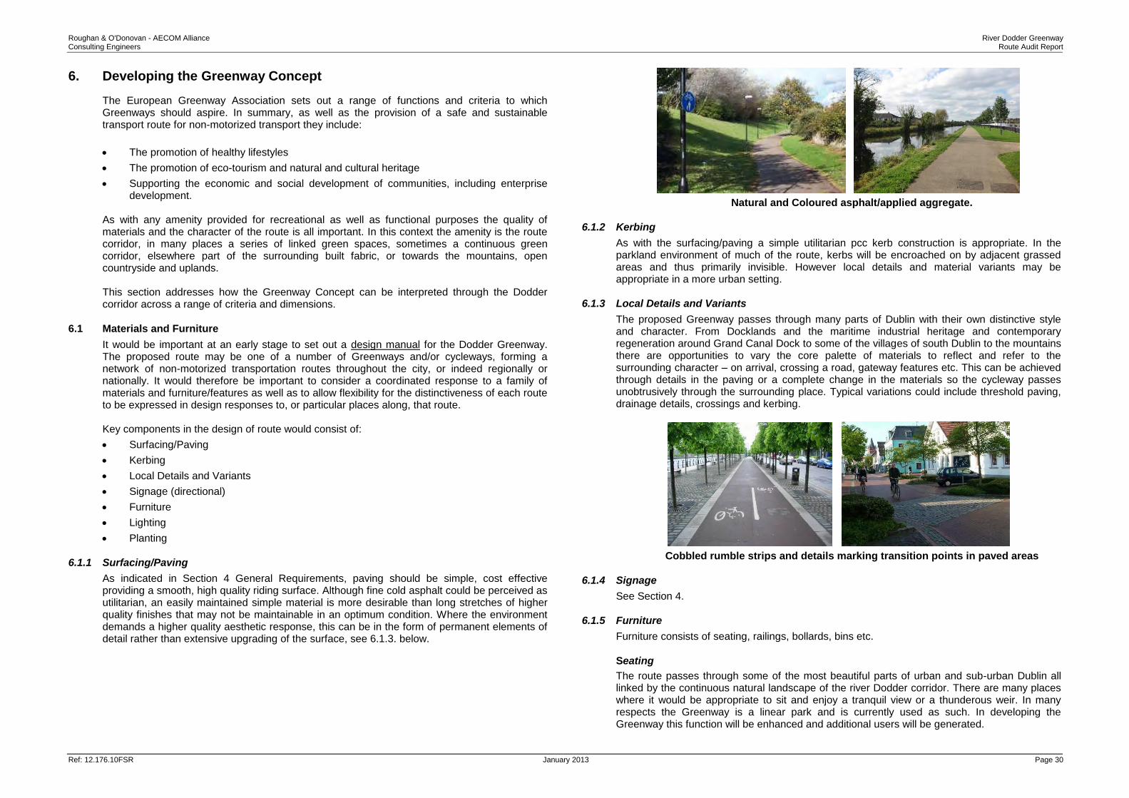
6.1.1 Surfacing/Paving
As indicated in Section 4 General Requirements, paving should be simple, cost effective providing a smooth, high quality riding surface. Although fine cold asphalt could be perceived as utilitarian, an easily maintained simple material is more desirable than long stretches of higher quality finishes that may not be maintainable in an optimum condition. Where the environment demands a higher quality aesthetic response, this can be in the form of permanent elements of detail rather than extensive upgrading of the surface, see 6.1.3. below.
Natural and Coloured asphalt/applied aggregate.
6.1.2 Kerbing
As with the surfacing/paving a simple utilitarian pcc kerb construction is appropriate. In the parkland environment of much of the route, kerbs will be encroached on by adjacent grassed areas and thus primarily invisible. However local details and material variants may be appropriate in a more urban setting.
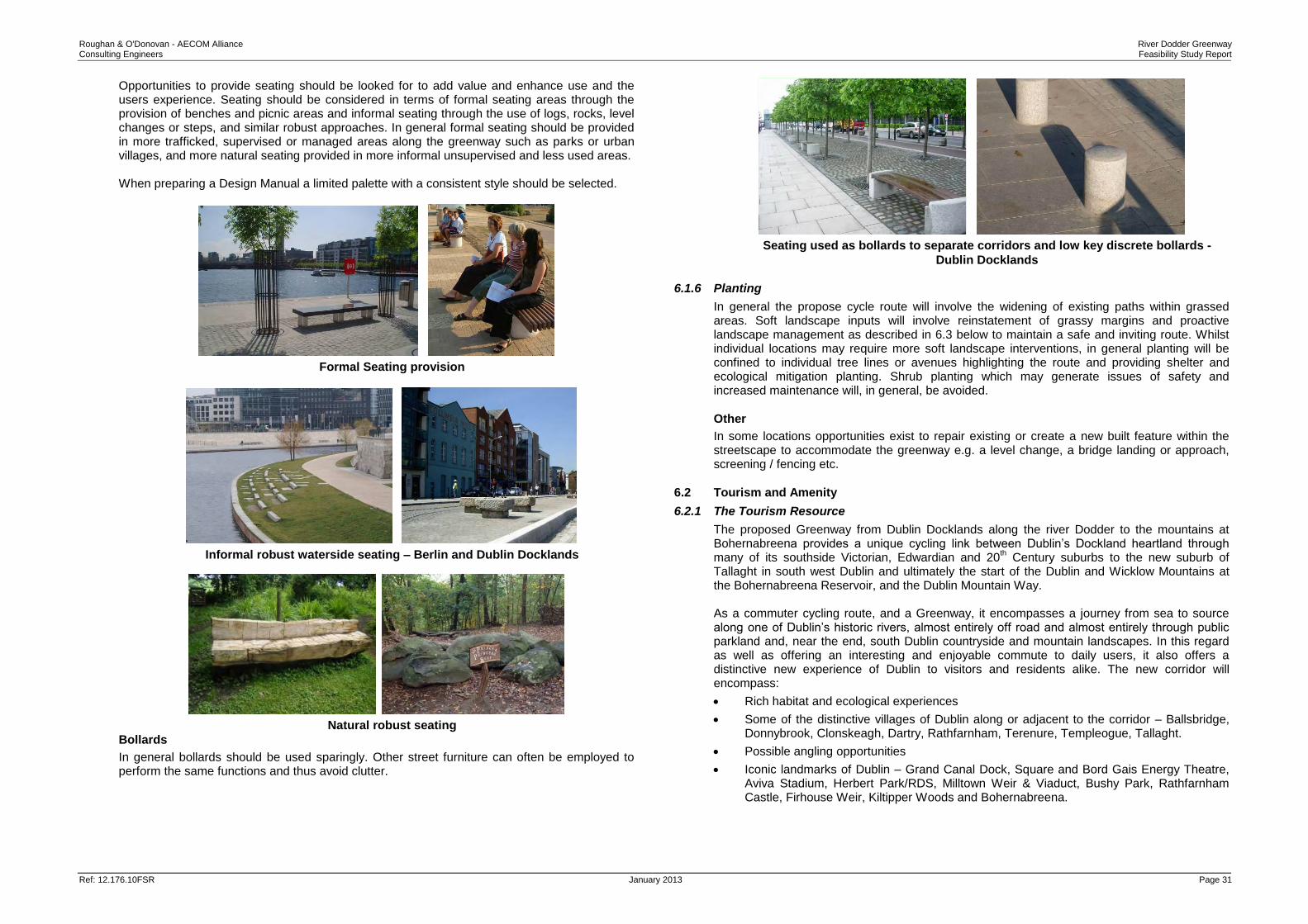
6.1.3 Local Details and Variants
The proposed Greenway passes through many parts of Dublin with their own distinctive style and character. From Docklands and the maritime industrial heritage and contemporary regeneration around Grand Canal Dock to some of the villages of south Dublin to the mountains there are opportunities to vary the core palette of materials to reflect and refer to the surrounding character – on arrival, crossing a road, gateway features etc. This can be achieved through details in the paving or a complete change in the materials so the cycleway passes unobtrusively through the surrounding place. Typical variations could include threshold paving, drainage details, crossings and kerbing.
Cobbled rumble strips and details marking transition points in paved areas
6.1.4 Signage
See Section 4.
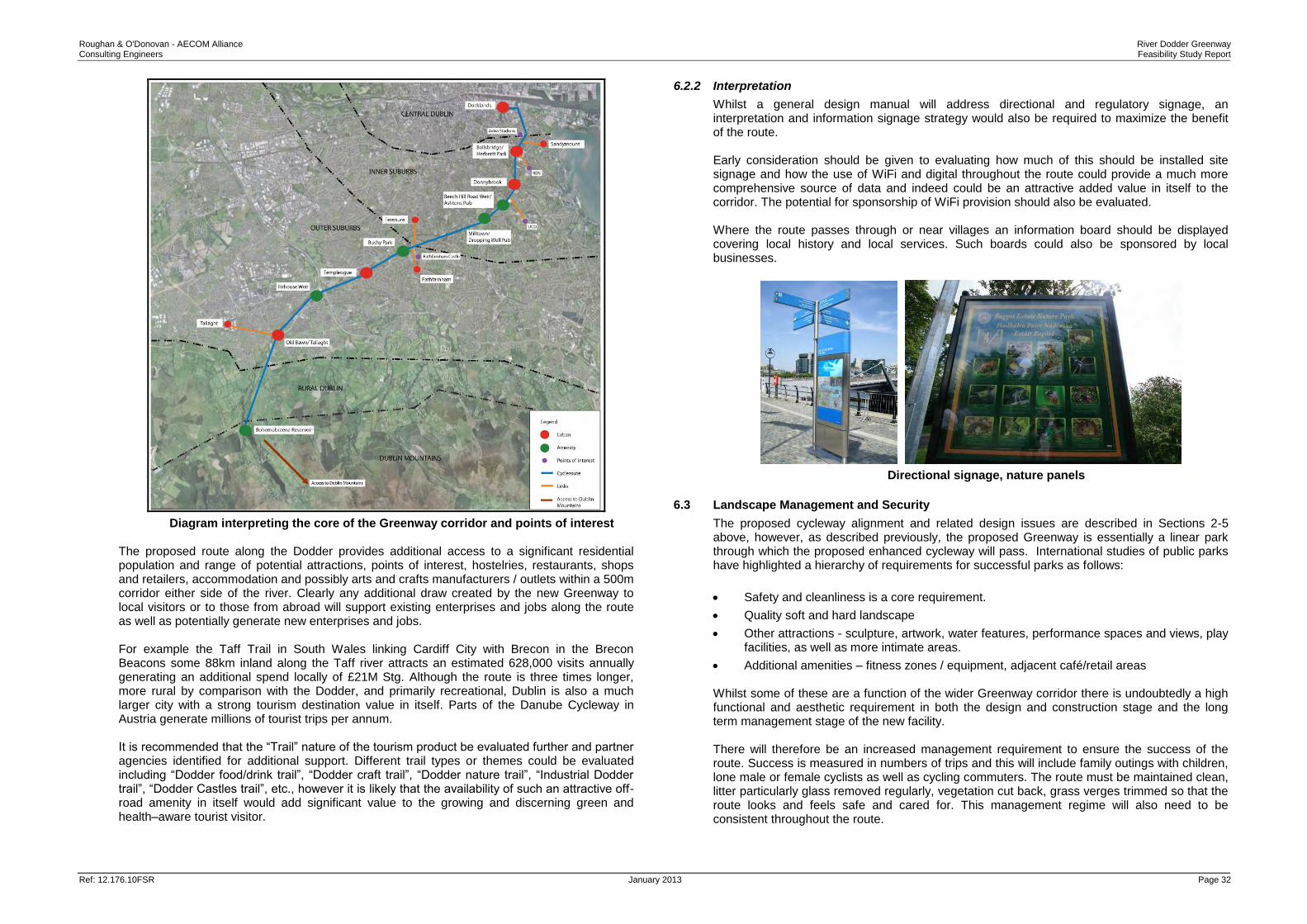
6.1.5 Furniture
Furniture consists of seating, railings, bollards, bins etc.
Seating
The route passes through some of the most beautiful parts of urban and sub-urban Dublin all linked by the continuous natural landscape of the river Dodder corridor. There are many places where it would be appropriate to sit and enjoy a tranquil view or a thunderous weir. In many respects the Greenway is a linear park and is currently used as such. In developing the Greenway this function will be enhanced and additional users will be generated.
Roughan & O'Donovan - AECOM Alliance River Dodder Greenway Consulting Engineers Feasibility Study Report
Ref: 12.176.10FSR January 2013 Page 31
Opportunities to provide seating should be looked for to add value and enhance use and the users experience. Seating should be considered in terms of formal seating areas through the provision of benches and picnic areas and informal seating through the use of logs, rocks, level changes or steps, and similar robust approaches. In general formal seating should be provided in more trafficked, supervised or managed areas along the greenway such as parks or urban villages, and more natural seating provided in more informal unsupervised and less used areas. When preparing a Design Manual a limited palette with a consistent style should be selected.
Formal Seating provision
Informal robust waterside seating – Berlin and Dublin Docklands
Natural robust seating
Bollards
In general bollards should be used sparingly. Other street furniture can often be employed to perform the same functions and thus avoid clutter.
Seating used as bollards to separate corridors and low key discrete bollards -
Dublin Docklands
6.1.6 Planting
In general the propose cycle route will involve the widening of existing paths within grassed areas. Soft landscape inputs will involve reinstatement of grassy margins and proactive landscape management as described in 6.3 below to maintain a safe and inviting route. Whilst individual locations may require more soft landscape interventions, in general planting will be confined to individual tree lines or avenues highlighting the route and providing shelter and ecological mitigation planting. Shrub planting which may generate issues of safety and increased maintenance will, in general, be avoided.
Other
In some locations opportunities exist to repair existing or create a new built feature within the streetscape to accommodate the greenway e.g. a level change, a bridge landing or approach, screening / fencing etc.
6.2 Tourism and Amenity
6.2.1 The Tourism Resource
The proposed Greenway from Dublin Docklands along the river Dodder to the mountains at Bohernabreena provides a unique cycling link between Dublin’s Dockland heartland through many of its southside Victorian, Edwardian and 20
th Century suburbs to the new suburb of
Tallaght in south west Dublin and ultimately the start of the Dublin and Wicklow Mountains at the Bohernabreena Reservoir, and the Dublin Mountain Way. As a commuter cycling route, and a Greenway, it encompasses a journey from sea to source along one of Dublin’s historic rivers, almost entirely off road and almost entirely through public parkland and, near the end, south Dublin countryside and mountain landscapes. In this regard as well as offering an interesting and enjoyable commute to daily users, it also offers a distinctive new experience of Dublin to visitors and residents alike. The new corridor will encompass:
Rich habitat and ecological experiences
Some of the distinctive villages of Dublin along or adjacent to the corridor – Ballsbridge, Donnybrook, Clonskeagh, Dartry, Rathfarnham, Terenure, Templeogue, Tallaght.
Possible angling opportunities
Iconic landmarks of Dublin – Grand Canal Dock, Square and Bord Gais Energy Theatre, Aviva Stadium, Herbert Park/RDS, Milltown Weir & Viaduct, Bushy Park, Rathfarnham Castle, Firhouse Weir, Kiltipper Woods and Bohernabreena.
Roughan & O'Donovan - AECOM Alliance River Dodder Greenway Consulting Engineers Feasibility Study Report
Ref: 12.176.10FSR January 2013 Page 32
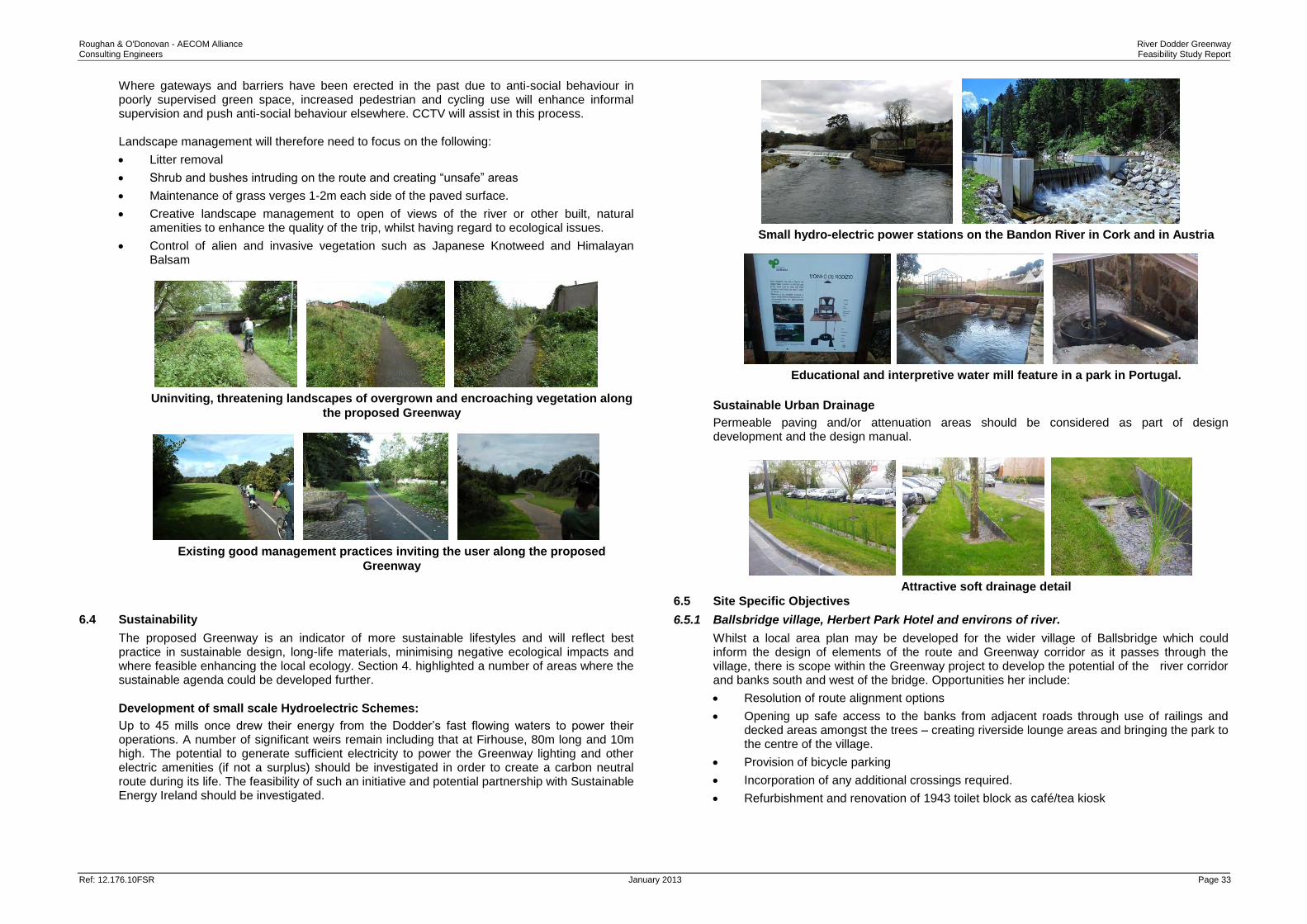
Diagram interpreting the core of the Greenway corridor and points of interest The proposed route along the Dodder provides additional access to a significant residential population and range of potential attractions, points of interest, hostelries, restaurants, shops and retailers, accommodation and possibly arts and crafts manufacturers / outlets within a 500m corridor either side of the river. Clearly any additional draw created by the new Greenway to local visitors or to those from abroad will support existing enterprises and jobs along the route as well as potentially generate new enterprises and jobs. For example the Taff Trail in South Wales linking Cardiff City with Brecon in the Brecon Beacons some 88km inland along the Taff river attracts an estimated 628,000 visits annually generating an additional spend locally of £21M Stg. Although the route is three times longer, more rural by comparison with the Dodder, and primarily recreational, Dublin is also a much larger city with a strong tourism destination value in itself. Parts of the Danube Cycleway in Austria generate millions of tourist trips per annum. It is recommended that the “Trail” nature of the tourism product be evaluated further and partner agencies identified for additional support. Different trail types or themes could be evaluated including “Dodder food/drink trail”, “Dodder craft trail”, “Dodder nature trail”, “Industrial Dodder trail”, “Dodder Castles trail”, etc., however it is likely that the availability of such an attractive off-road amenity in itself would add significant value to the growing and discerning green and health–aware tourist visitor.
6.2.2 Interpretation
Whilst a general design manual will address directional and regulatory signage, an interpretation and information signage strategy would also be required to maximize the benefit of the route. Early consideration should be given to evaluating how much of this should be installed site signage and how the use of WiFi and digital throughout the route could provide a much more comprehensive source of data and indeed could be an attractive added value in itself to the corridor. The potential for sponsorship of WiFi provision should also be evaluated. Where the route passes through or near villages an information board should be displayed covering local history and local services. Such boards could also be sponsored by local businesses.
Directional signage, nature panels
6.3 Landscape Management and Security
The proposed cycleway alignment and related design issues are described in Sections 2-5 above, however, as described previously, the proposed Greenway is essentially a linear park through which the proposed enhanced cycleway will pass. International studies of public parks have highlighted a hierarchy of requirements for successful parks as follows:
Safety and cleanliness is a core requirement.
Quality soft and hard landscape
Other attractions - sculpture, artwork, water features, performance spaces and views, play facilities, as well as more intimate areas.
Additional amenities – fitness zones / equipment, adjacent café/retail areas Whilst some of these are a function of the wider Greenway corridor there is undoubtedly a high functional and aesthetic requirement in both the design and construction stage and the long term management stage of the new facility. There will therefore be an increased management requirement to ensure the success of the route. Success is measured in numbers of trips and this will include family outings with children, lone male or female cyclists as well as cycling commuters. The route must be maintained clean, litter particularly glass removed regularly, vegetation cut back, grass verges trimmed so that the route looks and feels safe and cared for. This management regime will also need to be consistent throughout the route.
Roughan & O'Donovan - AECOM Alliance River Dodder Greenway Consulting Engineers Feasibility Study Report
Ref: 12.176.10FSR January 2013 Page 33
Where gateways and barriers have been erected in the past due to anti-social behaviour in poorly supervised green space, increased pedestrian and cycling use will enhance informal supervision and push anti-social behaviour elsewhere. CCTV will assist in this process. Landscape management will therefore need to focus on the following:
Litter removal
Shrub and bushes intruding on the route and creating “unsafe” areas
Maintenance of grass verges 1-2m each side of the paved surface.
Creative landscape management to open of views of the river or other built, natural amenities to enhance the quality of the trip, whilst having regard to ecological issues.
Control of alien and invasive vegetation such as Japanese Knotweed and Himalayan Balsam
Uninviting, threatening landscapes of overgrown and encroaching vegetation along
the proposed Greenway
Existing good management practices inviting the user along the proposed
Greenway
6.4 Sustainability
The proposed Greenway is an indicator of more sustainable lifestyles and will reflect best practice in sustainable design, long-life materials, minimising negative ecological impacts and where feasible enhancing the local ecology. Section 4. highlighted a number of areas where the sustainable agenda could be developed further.
Development of small scale Hydroelectric Schemes:
Up to 45 mills once drew their energy from the Dodder’s fast flowing waters to power their operations. A number of significant weirs remain including that at Firhouse, 80m long and 10m high. The potential to generate sufficient electricity to power the Greenway lighting and other electric amenities (if not a surplus) should be investigated in order to create a carbon neutral route during its life. The feasibility of such an initiative and potential partnership with Sustainable Energy Ireland should be investigated.
Small hydro-electric power stations on the Bandon River in Cork and in Austria
Educational and interpretive water mill feature in a park in Portugal.
Sustainable Urban Drainage
Permeable paving and/or attenuation areas should be considered as part of design development and the design manual.
Attractive soft drainage detail
6.5 Site Specific Objectives
6.5.1 Ballsbridge village, Herbert Park Hotel and environs of river.
Whilst a local area plan may be developed for the wider village of Ballsbridge which could inform the design of elements of the route and Greenway corridor as it passes through the village, there is scope within the Greenway project to develop the potential of the river corridor and banks south and west of the bridge. Opportunities her include:
Resolution of route alignment options
Opening up safe access to the banks from adjacent roads through use of railings and decked areas amongst the trees – creating riverside lounge areas and bringing the park to the centre of the village.
Provision of bicycle parking
Incorporation of any additional crossings required.
Refurbishment and renovation of 1943 toilet block as café/tea kiosk
Roughan & O'Donovan - AECOM Alliance River Dodder Greenway Consulting Engineers Feasibility Study Report
Ref: 12.176.10FSR January 2013 Page 34
View south from bridge to unused riverside banks and unused 1943 public toilet
Aerial View
The Thames at Richmond Killiney Hill kiosk cafe
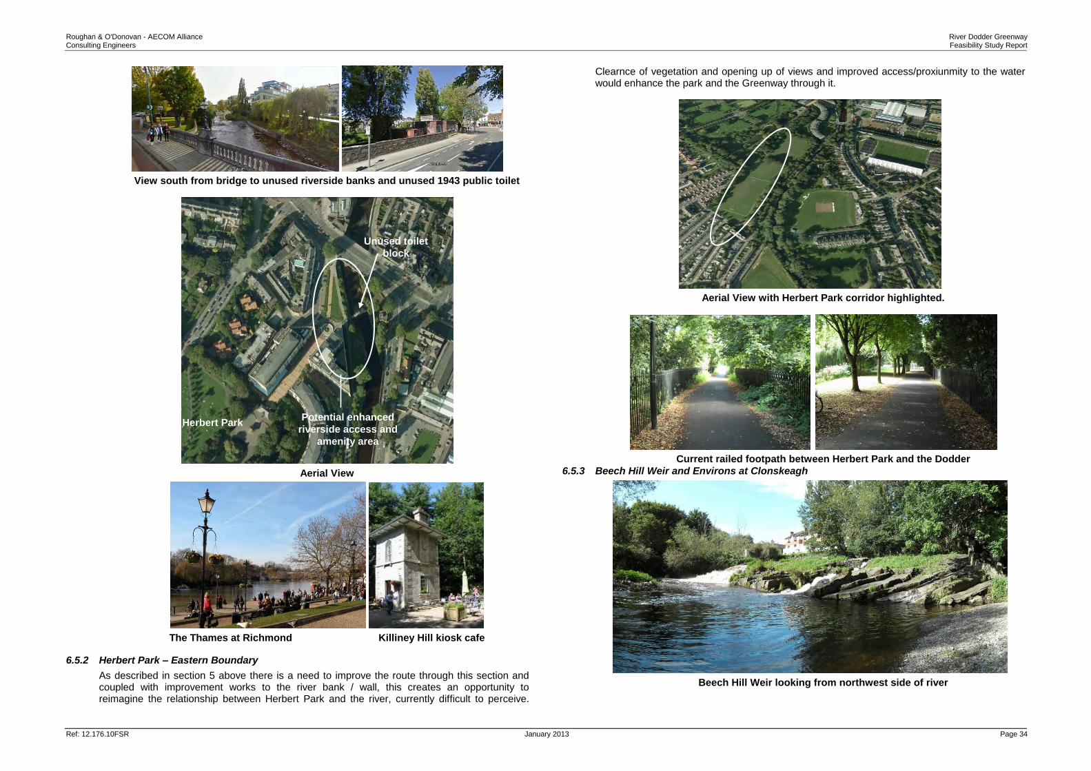
6.5.2 Herbert Park – Eastern Boundary
As described in section 5 above there is a need to improve the route through this section and coupled with improvement works to the river bank / wall, this creates an opportunity to reimagine the relationship between Herbert Park and the river, currently difficult to perceive.
Clearnce of vegetation and opening up of views and improved access/proxiunmity to the water would enhance the park and the Greenway through it.
Aerial View with Herbert Park corridor highlighted.
Current railed footpath between Herbert Park and the Dodder
6.5.3 Beech Hill Weir and Environs at Clonskeagh
Beech Hill Weir looking from northwest side of river
Unused toilet
block
Potential enhanced
riverside access and
amenity area
Herbert Park
Roughan & O'Donovan - AECOM Alliance River Dodder Greenway Consulting Engineers Feasibility Study Report
Ref: 12.176.10FSR January 2013 Page 35
Aerial View
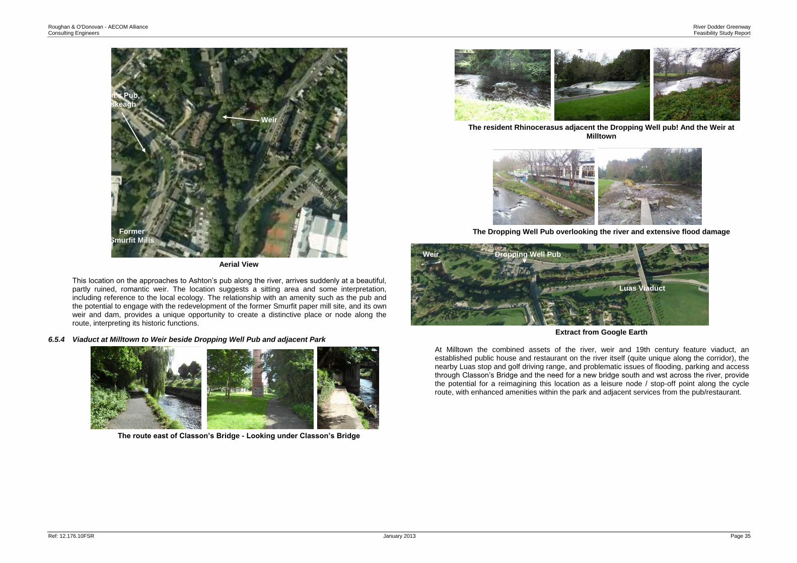
This location on the approaches to Ashton’s pub along the river, arrives suddenly at a beautiful, partly ruined, romantic weir. The location suggests a sitting area and some interpretation, including reference to the local ecology. The relationship with an amenity such as the pub and the potential to engage with the redevelopment of the former Smurfit paper mill site, and its own weir and dam, provides a unique opportunity to create a distinctive place or node along the route, interpreting its historic functions.
6.5.4 Viaduct at Milltown to Weir beside Dropping Well Pub and adjacent Park
The route east of Classon’s Bridge - Looking under Classon’s Bridge
The resident Rhinocerasus adjacent the Dropping Well pub! And the Weir at
Milltown
The Dropping Well Pub overlooking the river and extensive flood damage
Extract from Google Earth
At Milltown the combined assets of the river, weir and 19th century feature viaduct, an established public house and restaurant on the river itself (quite unique along the corridor), the nearby Luas stop and golf driving range, and problematic issues of flooding, parking and access through Classon’s Bridge and the need for a new bridge south and wst across the river, provide the potential for a reimagining this location as a leisure node / stop-off point along the cycle route, with enhanced amenities within the park and adjacent services from the pub/restaurant.
Ashton’s Pub,
Clonskeagh
Weir
Former
Smurfit Mills
Dropping Well Pub Weir
Luas Viaduct
Roughan & O'Donovan - AECOM Alliance River Dodder Greenway Consulting Engineers Feasibility Study Report
Ref: 12.176.10FSR January 2013 Page 36
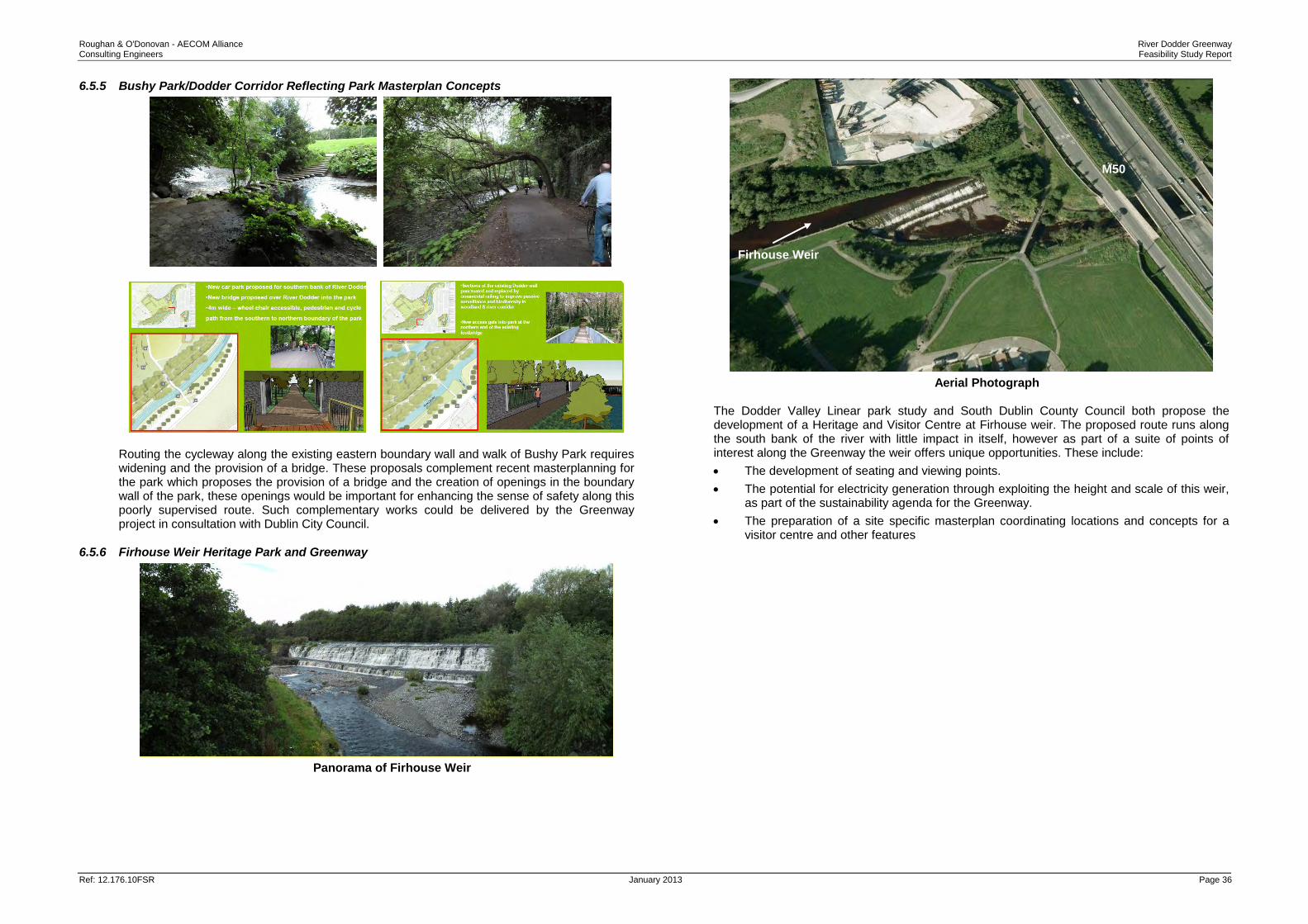
6.5.5 Bushy Park/Dodder Corridor Reflecting Park Masterplan Concepts
Routing the cycleway along the existing eastern boundary wall and walk of Bushy Park requires widening and the provision of a bridge. These proposals complement recent masterplanning for the park which proposes the provision of a bridge and the creation of openings in the boundary wall of the park, these openings would be important for enhancing the sense of safety along this poorly supervised route. Such complementary works could be delivered by the Greenway project in consultation with Dublin City Council.
6.5.6 Firhouse Weir Heritage Park and Greenway
Panorama of Firhouse Weir
Aerial Photograph The Dodder Valley Linear park study and South Dublin County Council both propose the development of a Heritage and Visitor Centre at Firhouse weir. The proposed route runs along the south bank of the river with little impact in itself, however as part of a suite of points of interest along the Greenway the weir offers unique opportunities. These include:
The development of seating and viewing points.
The potential for electricity generation through exploiting the height and scale of this weir, as part of the sustainability agenda for the Greenway.
The preparation of a site specific masterplan coordinating locations and concepts for a visitor centre and other features
The legal requirements for Environmental Impact Assessment of a road development are defined in the Roads Act (1993) as amended by the Planning and Development Acts (2000 – 2011) and the Roads Act (2007), and by Regulations made under the Roads Acts, The European Communities (Environmental Impact Assessment) (Amendment) Regulations 1989 – 2001 and the EC Directives 85/337/EC and 97/11/EC. The proposed development falls under the requirements of the Roads Act as “Road” is defined within the act to include:
(a) any street, lane, footpath, square, court, alley or passage,
(b) any bridge, viaduct, underpass, subway, tunnel, overpass, overbridge flyover, carriageway whether single or multiple, pavement or footway,
(c) any weighbridge or other facility for the weighting or inspection of vehicles, toll plaza or other facility for the collection of tolls, services area, emergency, telephone, first aid post, culvert, arch, gulley, railing, fence, wall, barrier, guardrail, margin, kerb, lay-by, hard shoulder, island, pedestrian refuge, median, central reserve
A summary of the relevant provisions of the Roads Acts in relation to Environmental Impact Statements for a public road development is set out below. Environmental Impact Statement (EIS) Section 50 of the Roads Act, 1993 as amended by Section 9(d)(i)(a) of the Roads Act 2007 states: “A road authority or the Authority shall prepare a statement of the likely effects on the environment (‘environmental impact statement’) of any proposed road development consisting of... (III.) Any prescribed type of proposed road development consisting of the construction of a
proposed public road or the improvement of an existing public road.” The prescribed type of road development as defined in S.I. No. 119 of 1994 paragraph 8, is defined for the purpose of subsection (1) (a) (iii) of section 50 of the acts as follows: “(c) Where a road authority considers that any proposed road development ...consisting of the construction of a public road or the improvement of an existing public road would be likely to have significant effects on the environment, it shall inform the Board in writing and where the board concurs with the road authority it shall give a direction to the road authority...” Furthermore, S.I. No 119, 1994 was amended by the insertion of section (d) from Section 14, Paragraph (a) of the European Communities (Environmental Impact Assessment) (Amendment) Regulations 1999 with the following: “(d) Where a proposed road development ... consisting of the construction of a proposed public road or the improvement of an existing public road would be located on:
(i) a special area of conservation,
(ii) a site notified in accordance with Regulation 4 of the European Communities (Natural Habitats) Regulations, 1997 ( S.I. No. 94 of 1997 ),
(iii) an area classified pursuant to paragraph (1) of (2) of article 4 of Council Directive No. 79/409/EEC of 2 April, 1979, on the conservation of wild birds (O.J. No. L 103, 25 April, 1979),
(iv) a site where consultation has been initiated in accordance with article 5 of Council Directive 92/43/EEC of 21 May, 1992, on the conservation of natural habitats and of wild fauna and flora (O.J. No. L 206, 22 July, 1992),
(v) land established or recognised as a nature reserve within the meaning of section 15 or 16 of the Wildlife Act, 1976 (No. 39 of 1976)
The road authority concerned shall decide whether the proposed road development would or would not be likely to have significant effects on the environment. “ Where a development is sub-threshold, the decision as to the requirement for EIA must be decided on a case by case basis. Article 27 of the Third Schedule of S.I. No. 93 of 1999 and Schedule 7 of the Planning and Development Regulations 2001 (S.I. No. 600 of 2001) provides ‘criteria for determining whether a development would or would not be likely to have significant effects on the environment’. These are copied below: 1. Characteristics of proposed development
The characteristics of proposed development, in particular:
the size of the proposed development;
the cumulation with other proposed development,
the use of natural resources,
the production of waste,
pollution and nuisances,
the risk of accidents, having regard to substances or technologies used.
2. Location of proposed development
The environmental sensitivity of geographical areas likely to be affected by proposed development, having regard in particular to:
the existing land use,
the relative abundance, quality and regenerative capacity of natural resources in the area,
the absorption capacity of the natural environment, paying particular attention to the following areas:
a. wetlands,
b. coastal zones,
c. mountain and forest areas,
d. nature reserves and parks,
e. areas classified or protected under legislation, including special protection areas designated pursuant to Directives 79/409/EEC and 92/43/EEC,
f. areas in which the environmental quality standards laid down in legislation of the EU have already been exceeded,
g. densely populated areas,
h. landscapes of historical, cultural or archaeological significance.
3. Characteristics of potential impacts
The potential significant effects of proposed development in relation to criteria set out under paragraphs 1 and 2 above, and having regard in particular to:
Roughan & O'Donovan - AECOM Alliance River Dodder Greenway Consulting Engineers Feasibility Study Report
Ref: 12.176.10FSR January 2013 Page 38
the extent of the impact (geographical area and size of the affected population),
the transfrontier nature of the impact,
the magnitude and complexity of the impact,
the probability of the impact,
the duration, frequency and reversibility of the impact. The proposed scheme does not register on Schedule 5 as a project automatically requiring EIA. It does however lie alongside the River Dodder which is an important ecological corridor. In addition the river is sourced in the Glensamole Valley SAC and flows into the River Liffey which flows into Dublin Bay SAC/SPA. The route additionally crosses though the Dodder River Valley proposed Natural Heritage Area. As these sites are specifically referenced under Criteria 2 of Schedule 7 it is important that it is determined whether or not EIA is required.
7.2 Guidance and Methodology
The following documents were reviewed for the purpose of this assessment:
European Commission Guidance on EIA Screening (2001); and
Department of the Environment, Heritage and Local Government Guidance for Consent Authorities regarding sub-threshold Development (2003).
The first two stages in the EIA process are ‘Screening’ and ‘Scoping’. Screening is that part of the EIA process which determines whether an EIA is required for a particular project; Scoping is the activity of deciding on matters to be investigated as part of the EIA. The EC Guidance on EIA Screening highlights that these two can overlap as a preliminary assessment of the environmental issues may be undertaken to assist in the screening decision. Therefore, in order to determine whether or not this project requires EIA, a preliminary assessment of the topics has been carried out to make this determination i.e. a Screening Assessment, and is outlined below.
7.3 Screening Assessment on Aspects of the Environment
7.3.1 Air Quality and Climate
The River Dodder Greenway involves the design and construction of a high quality cycling and pedestrian trail from the mouth of the River Dodder at Grand Canal Dock to the mountains at Glensamole Valley and is principally along the existing pathways through the River Dodder corridor. The objective of the project is to increase the number of cyclist and pedestrian journeys throughout the route. At operation stage, it is therefore considered that there will be no impact on air quality or climate. Similarly, it is considered that the level of construction traffic required for a project of this scale will have no appreciable impact on the local air quality or climate nor will a construction project of this scale result in any significant generation of dust.
7.3.2 Noise and Vibration
At operation stage, an increase in the number of cyclists or pedestrians will have negligible impact on noise or vibration in the local environment. It is also considered that the level of construction traffic and construction operations required for a project of this scale will not result in the creation of any significant levels of noise or vibration. Furthermore, works will be carried out in compliance with BS5228: Part 1 and the European Communities (Noise Emission by Equipment for Use Outdoors) Regulations, 2001, which will ensure a controlled level of noise during construction phase.
7.3.3 Soils and Geology
Due to the scale of the project and the minimal volume of excavation required, it is not anticipated that there will be any significant impacts on soils and geology as a consequence of the construction or operation of the scheme.
7.3.4 Hydrology
The principal potential impacts to surface water are associated with discharges to the receiving watercourses – in this case the River Dodder. It is anticipated that there will be no impact on hydrology or water quality during the operational phase of the Greenway During the construction stage, there is potential for pollution of the river to occur as a result of sediment loading arising from surface water run-off or spills on site. It is considered that the enforcement of industry best practice pollution prevention measures will prevent the occurrence of a pollution event (for example CIRIA Guideline Document C532 Control of Water Pollution from Construction Sites and C648 Control of water pollution from linear construction projects). As such, no the proposed scheme will not adversely affect hydrology.
7.3.5 Hydrogeology
Hydro-geological assessment addresses the potential impact of the proposed project on groundwater features and groundwater flow regime. As the cycleway will be largely on existing pathways and will require no significant cuttings for construction, it is concluded that there will be no appreciable impact on the groundwater regime during either the construction or operational stages.
7.3.6 Ecology (Flora and Fauna)
The site lies alongside and within the River Dodder corridor. The project will be designed to ensure that no permanent adverse impact occurs that would affect the Ecology of the site. In particular, habitats and species that are legally protected will be avoided as part of the design process and a suite of measures will be put in place to ensure that no adverse effects on habitats and species occur during the construction stage. A Habitats Directive Screening for Appropriate Assessment is required (appended hereto) in order to address the potential impact on SACs and SPAs within and in proximity to the site. This Assessment addresses the potential impact the project may have on the Qualifying Features (Habitats and Species) of the designated sites and the conservation objectives for same. The project generally follows existing walkways where widening will be required, and along these areas, the site is made up of a range of habitats included calcareous grasslands, riparian woodlands, tufa forming springs, wet grasslands, amenity lands, parklands and scrub. Species of importance include lamprey, salmon, otter, bats and kingfisher. The design should avoid areas where important habitats or species are present. The aquatic habitat present will be crossed in several locations by footbridges. There will generally be no instream works (other than possible enhancements for the local ecology) and water quality control measures at construction will ensure there is no impact on the populations of fish through pollution or sedimentation. As a consequence of the proximity of the existing walkways and cycle tracks to the River Dodder, the design will require consideration of habitats and species of importance along the route in particular to protection of otter and kingfisher habitat and water quality to ensure there
Roughan & O'Donovan - AECOM Alliance River Dodder Greenway Consulting Engineers Feasibility Study Report
Ref: 12.176.10FSR January 2013 Page 39
will be no impact on the availability of otter prey items. Similarly, it is considered that there will be no impact on Kingfisher nesting habitat (eroding banks into which the Kingfisher excavate the nest burrow) and there will be no loss of favoured hunting perches. Calcareous Grassland and Tufa forming calcareous springs will be avoided as part of the route design. The impact on trees in the riparian environment is in places unavoidable, however effort will be made to minimise the loss of trees throughout the route. The ecological assessment at preliminary design stage should assess the potential impact on biodiversity, species and habitats as part of the planning process.
7.3.7 Archaeology, Architecture and Cultural Heritage
It is considered that the cycleway project will have no direct impact on any sites of historical and cultural importance and with the correct archaeological and architectural supervision, serve to enhance any sites present or in proximity through improved access and interpretation. However, the design will of the project will nonetheless require an assessment of the impact on the archaeological and architectural resource, the identification of required mitigation measures and input to the interpretation strategy by a cultural heritage expert with archaeological & architectural conservation expertise.
7.3.8 Material Assets
A construction project may affect assets if it involves any of the following:
Acquisition of land;
Loss of land used by the community;
Demolition of private property;
Revaluation of or change in the development potential of adjoining lands / properties. The proposed scheme does not require the demolition of any buildings but acquisition of land is required in sections of the scheme. The scheme will provide an asset to the community as a commuting and amenity resource. There will be limited impact on private property and hence the impact on Material Assets can be considered as minimal or positive with respect to the provision of improved amenities.
7.3.9 Landscape and Visual Amenity
The proposed Greenway is essentially an improvement to and existing route and will therefore not entail an appreciable adverse impact on the River Dodder landscape. The cycleway will not detract from the existing views of the river or views to or from any natural and built heritage features present. Landscaping design has the potential to create a positive landscape and visual impact through the provision improvement of the degraded sections of the corridor and of additional views and interpretation of river corridor and its natural and designed heritage. During the construction stage, it is inevitable that the temporary presence of plant and machinery along the river corridor will detract from certain views and amenity. However this is considered to be only a slight temporary impact which is easily offset by the benefits accrued at the operational stage.
7.3.10 Socio-economic
The objective of any socio-economic assessment is to examine the potential impact of the construction and operation of the proposed development on the local community and business activities in the local area.
The opening of the greenway will have only beneficial impacts as it will attract people to the area thereby having a knock on economic effect with respect services in the form of commuting and recreational tourism, restaurants, cafes etc. Similarly, during construction, the influx of construction workers will benefit the local economy. This is supported by the evidence gathered in support of similar projects; for example a survey by Mayo County Council concluded that a 145,000 persons used the Great Western Greenway (Westport – Achill) in Mayo in its first year of opening.
7.3.11 Resource and Waste Management
The key phase with regard to resource and waste management is the construction phase. As the cycleway is largely an improvement to an existing route, there will be no requirement for any significant cut or fill. It is therefore considered that there will not be a significant amount of waste generated from the construction of the scheme and efforts will be made to reuse material on site where possible thus minimising waste.
7.4 Screening Conclusion and Recommendation
When the criteria in Schedule 3 of the EC (EIA) (Amendment) Regulations 1999 and Schedule 7 of the Planning and Development Regulations (2001) are reviewed in the context of the above preliminary assessment of potential environmental impacts it is concluded that a full Environmental Impact Assessment is not required. While the cycleway is located alongside and within an area which is considered sensitive and does have a low absorption capacity with respect to potentially damaging development, in this instance the characteristics of the proposed development have been shown to be relatively benign and it has been concluded that the potential impacts will be negligible or positive. However due to the potential impact on the biodiversity of the river corridor and the River Dodder Valley pNHA it is recommended that an Ecological Impact Assessment and Habitats Directive Screening for Appropriate Assessment be completed and submitted alongside any future planning application (The screening for the Appropriate Assessment has already been undertaken provisionally and is appended hereto). This conclusion is reflected in DEHLG Guidance for Consent Authorities regarding sub-threshold Development (2003) which quotes at Section 5.25 that ‘where an assessment is considered necessary under the Habitats Directive, it does not automatically mean that an EIA is the necessary form of assessment’. In addition due to the potential to impact on historical and cultural heritage resource the project will require the advice of and input from a cultural heritage expert with archaeological & architectural conservation expertise. Section 179 of the Planning and Development Act 2000, and Part 8 of the Planning Regulations 2001 set out the process to be used for planning approval for local authority projects that are not subject to a requirement for a formal Environmental Impact Statement (EIS) under other relevant legislation. The planning approval process will involve a period of public consultation (including relevant statutory bodies) after which the Local Authorities will review any submissions made. The final decision to approve or reject the scheme will be made at a meeting of the elected members of the County Council. It is therefore recommended that the scheme be advanced on the basis of three separate Part VIII Planning Applications (one in each of the three affected local authority jurisdictions). A single Environmental Impact Report (and relevant screening documents) should be undertaken for the entire route corridor to ensure that no accusation of project splitting can arise. The need for full EIA and the preparation of an EIS should be reviewed as the preliminary design progresses and the conclusions of this report amended as necessary if the design varies significantly from that contemplated herein.
Roughan & O'Donovan - AECOM Alliance River Dodder Greenway Consulting Engineers Feasibility Study Report
Ref: 12.176.10FSR January 2013 Page 40
8. Implementation While it would be desirable to deliver the scheme, as proposed in this report, in full, as a single construction project, that may prove impracticable from a funding perspective. Therefore, three different implementation options have been investigated: 1) Do maximum: the scheme as proposed in this report, in full. 2) Do medium: A reasonable standard greenway with key pinch points addressed and lighting and cctv provided. 3) Do minimum: A minimal scheme to establish a continuous cycleable route along the Dodder corridor. These are discussed in turn below.
8.1 Do Maximum Scheme
Subject to funding availability, it would be desirable to construct the entire scheme, which would consist of the following elements:
1) Resurfacing of Misery Hill and Hannover Quay 2) Construction of new opening bridges across Grand Canal Dock Locks. 3) Resurfacing of South Dock Road 4) Construction of a new ramp to Ringsend Road 5) Construction of a toucan crossing on Ringsend Road 6) Construction of new 2m wide bridge north of Ringsend Road Bridge 7) Construction of new 4m wide bridge south of Ringsend Road Bridge 8) Reconfiguration of Fitzwilliam Quay 9) Improvements to toucan crossing of Bath Avenue 10) Construction of new boardwalk from Bath Avenue to Lansdowne Road 11) Construction of new toucan crossing of Lansdowne Road 12) Construction of new underpass at the East Coast Railway 13) Construction of new bridge linking to the Oval from Beatty's Avenue 14) Construction of a toucan crossing at Ball's Bridge and reconfiguration of the junctions of
Pembroke Road / Merrion Road with Shelbourne Road and Anglesea Road 15) Acquisition of lands from the Herbert Park complex 16) Upgrade of the route through Herbert Park 17) Resurfacing of Eglinton Terrace 18) Construction of a toucan crossing on Donnybrook Road and rearrangement of the
footpaths on either side of the road 19) Resurfacing of Brookvale 20) Reconstruction of the Brookvale / Eglinton Road junction 21) Widening of the path from Brookvale to Ashtons 22) Regrading of the path from Ashtons to Clonskeagh Road 23) Two-way cycle track on west side of Clonskeagh Road 24) New bridge over Clonskeagh Weir - landmark feature bridge 25) New boardwalk along Beech Hill Road to Clonskeagh Road 26) Widening of route from Clonkseagh Road to Dundrum Road 27) Construction of new route north of river between Clonskeagh Road and Dundrum Road
north of river 28) Improvements to toucan crossing of Dundrum Road 29) Lighting of Dundrum Road underpass 30) Widening of routes north and south of river between Dundrum Road and Lower
Churchtown Road (Classon's Bridge) 31) New link from route north of river to Richmond Hill with toucan crossing of Milltown Road
32) Widening of route under north arch of Classon's Bridge by construction of a boardwalk and regrading of the ground.
33) Widening of route past Dropping Well 34) Widening and realignment of route through Dartry Park East 35) New bridge across Milltown Weir - landmark feature bridge 36) Land acquisition from Milltown Golf Club and construction of path along oxbow river
alignment to Dartry Park West 37) New bridge to Dartry Park West 38) Widening / resurfacing of both paths through Dartry Park West 39) Regrading of approaches to Orwell Gardens Bridge 40) Improvements to route between Dartry Park West and Orwell Park 41) Improvements to route through Orwell Park 42) New bridge to Lower Dodder Road 43) Minor improvements and angling platform on Lower Dodder Road 44) Resurfacing of Lower Dodder Road cul de sac 45) New underpass under Rathfarnham Road 46) Widening of path through green area west of Rathfarnham Road 47) New bridge to Bushy Park 48) Improvements to route along Bushy Park to Riverside Cottages 49) New bridge from Riverside cottages to Kilvere 50) Widening of path around Kilvere 51) New bridge from Kilvere to north side of river 52) Land acquisition and construction of 4m wide path to Oldbridge Road 53) Boardwalk / structure at escarpment just east of Oldbridge Road 54) New 4m route through Ladyswell continuing behind Cheeverstown Centre 55) New bridge to rear of St. Brendan's complex 56) New link from Firhouse Weir to Dodder Valley Park 57) New link from Dodder Valley Park to rear of Victory Centre including bridge over river
tributary 58) Improvements to path between Victory Centre and Old Bawn Road 59) Construction of new toucan crossing of Old Bawn Road 60) Acquisition of land and construction of new route from Old Bawn Road to Kiltipper
Woods Cafe 61) Construction of new toucan crossing of Bohernabreena Road 62) Acquisition of land and construction of new 4m wide route to complete link to
Bohernabreena.
Additionally, the scheme includes provision of public lighting and cctv along the entire route (except cctv not proposed at Beatty's Avenue or Lower Dodder Road, where passive supervision is available, or at Kiltipper Park at the extreme southwestern end of the route. The scheme also includes the removal of all kissing gates along the route.
8.2 Do Medium Scheme
The do medium scheme is sufficient to provide a reasonable standard greenway along the route of the River Dodder. The following compares the inclusions in the scheme to those in the Do Maximum scenario (omissions / alterations indicated by strikethrough).
1) Resurfacing of Misery Hill and Hannover Quay Provision of link from Hannover Quay onto campshire
2) Construction of new opening bridges across Grand Canal Dock Locks. 3) Resurfacing of South Dock Road 4) Construction of a new ramp to Ringsend Road 5) Construction of a toucan crossing on Ringsend Road 6) Construction of new 2m wide bridge north of Ringsend Road Bridge
Roughan & O'Donovan - AECOM Alliance River Dodder Greenway Consulting Engineers Feasibility Study Report
Ref: 12.176.10FSR January 2013 Page 41
7) Construction of new 4m wide bridge south of Ringsend Road Bridge 8) Reconfiguration of Fitzwilliam Quay 9) Improvements to toucan crossing of Bath Avenue 10) Construction of new boardwalk from Bath Avenue to Lansdowne Road 11) Construction of new toucan crossing of Lansdowne Road 12) Construction of new underpass at the East Coast Railway 13) Construction of new bridge linking to the Oval from Beatty's Avenue 14) Construction of a toucan crossing at Ball's Bridge and reconfiguration of the junctions of
Pembroke Road / Merrion Road with Shelbourne Road and Anglesea Road 15) Acquisition of lands from the Herbert Park complex 16) Upgrade of the route through Herbert Park 17) Resurfacing of Eglinton Terrace 18) Construction of a toucan crossing on Donnybrook Road and rearrangement of the
footpaths on either side of the road 19) Resurfacing of Brookvale 20) Reconstruction of the Brookvale / Eglinton Road junction 21) Widening of the path from Brookvale to Ashtons 22) Regrading of the path from Ashtons to Clonskeagh Road 23) Two-way cycle track on west side of Clonskeagh Road 24) New bridge over Clonskeagh Weir - landmark feature bridge 25) New boardwalk along Beech Hill Road to Clonskeagh Road 26) Widening of route from Clonkseagh Road to Dundrum Road 27) Construction of new route north of river between Clonskeagh Road and Dundrum Road
north of river 28) Improvements to toucan crossing of Dundrum Road 29) Lighting of Dundrum Road underpass 30) Widening of routes north and south of river between Dundrum Road and Lower
Churchtown Road (Classon's Bridge) Widening of route south of river between Dundrum Road and Lower Churchtown Road (Classon's Bridge)
31) New link from route north of river to Richmond Hill with toucan crossing of Milltown Road 32) Widening of route under north arch of Classon's Bridge by construction of a boardwalk
and regrading of the ground. 33) Widening of route past Dropping Well 34) Widening and realignment of route through Dartry Park East 35) New bridge across Milltown Weir - landmark feature bridge 36) Land acquisition from Milltown Golf Club and construction of path along oxbow river
alignment to Dartry Park West 37) New bridge to Dartry Park West 38) Widening / resurfacing of both paths along river through Dartry Park West 39) Regrading of approaches to Orwell Gardens Bridge 40) Improvements to route between Dartry Park West and Orwell Park 41) Improvements to route through Orwell Park 42) New bridge to Lower Dodder Road 43) Minor improvements and angling platform on Lower Dodder Road 44) Resurfacing of Lower Dodder Road cul de sac 45) New underpass under Rathfarnham Road Construction of new toucan crossing and
rearrangement of signal staging at Rathfarnham Road Crossing 46) Widening of path through green area west of Rathfarnham Road 47) New bridge to Bushy Park 48) Improvements to route along Bushy Park to Riverside Cottages 49) New bridge from Riverside cottages to Kilvere 50) Widening of path around Kilvere 51) New bridge from Kilvere to north side of river 52) Land acquisition and construction of 4m wide path to Oldbridge Road
53) Boardwalk / structure at escarpment just east of Oldbridge Road 54) New 4m route through Ladyswell continuing behind Cheeverstown Centre 55) New bridge to rear of St. Brendan's complex 56) New link from Firhouse Weir to Dodder Valley Park 57) New link from Dodder Valley Park to rear of Victory Centre including bridge over river
tributary 58) Improvements to path between Victory Centre and Old Bawn Road 59) Construction of new toucan crossing of Old Bawn Road 60) Acquisition of land and construction of new route from Old Bawn Road to Kiltipper
Woods Cafe 61) Construction of new toucan crossing of Bohernabreena Road 62) Acquisition of land and construction of new 4m wide route to complete link to
Bohernabreena.
The scheme includes public lighting and cctv as in the do maximum scheme, except for exclusion of cctv along Bushy Park and Herbert Park and along other sections where works are not proposed as part of the scheme.
8.3 Do Minimum Scheme
The do minimum scheme is sufficient to provide a passable cycleway along the route of the River Dodder. The following compares the inclusions in the scheme to those in the Do Maximum scenario (omissions / alterations indicated by strikethrough).
1) Resurfacing of Misery Hill and Hannover Quay Provision of link from Hannover Quay onto campshire
2) Construction of new opening bridges across Grand Canal Dock Locks. 3) Resurfacing of South Dock Road 4) Construction of a new ramp to Ringsend Road 5) Construction of a toucan crossing on Ringsend Road 6) Construction of new 2m wide bridge north of Ringsend Road Bridge 7) Construction of new 4m wide bridge south of Ringsend Road Bridge 8) Reconfiguration of Fitzwilliam Quay 9) Improvements to toucan crossing of Bath Avenue 10) Construction of new boardwalk from Bath Avenue to Lansdowne Road Reconfiguration
of London Bridge and Lansdowne Road Bridge for shuttle operation for vehicular traffic and provision of 3m wide cycleway / footway on one side. Widening of path past Aviva Stadium to 4m.
11) Construction of new toucan crossing of Lansdowne Road 12) Construction of new underpass at the East Coast Railway Retention of existing
underpass as a pinchpoint along the route. 13) Construction of new bridge linking to the Oval from Beatty's Avenue 14) Construction of a toucan crossing at Ball's Bridge and reconfiguration of the junctions of
Pembroke Road / Merrion Road with Shelbourne Road and Anglesea Road 15) Acquisition of lands from the Herbert Park complex 16) Upgrade of the route through Herbert Park 17) Resurfacing of Eglinton Terrace 18) Construction of a toucan crossing on Donnybrook Road and rearrangement of the
footpaths on either side of the road 19) Resurfacing of Brookvale 20) Reconstruction of the Brookvale / Eglinton Road junction 21) Widening of the path from Brookvale to Ashtons 22) Regrading of the path from Ashtons to Clonskeagh Road 23) Two-way cycle track on west side of Clonskeagh Road 24) New bridge over Clonskeagh Weir - landmark feature bridge
Roughan & O'Donovan - AECOM Alliance River Dodder Greenway Consulting Engineers Feasibility Study Report
Ref: 12.176.10FSR January 2013 Page 42
25) New boardwalk along Beech Hill Road to Clonskeagh Road 26) Widening of Retention of existing route from Clonkseagh Road to Dundrum Road 27) Construction of new route north of river between Clonskeagh Road and Dundrum Road
north of river 28) Improvements to toucan crossing of Dundrum Road 29) Lighting of Dundrum Road underpass 30) Widening of routes north and south of river between Dundrum Road and Lower
Churchtown Road (Classon's Bridge) Widening of route south of river between Dundrum Road and Lower Churchtown Road (Classon's Bridge)
31) New link from route north of river to Richmond Hill with toucan crossing of Milltown Road 32) Widening of route under north arch of Classon's Bridge by construction of a boardwalk
and regrading of the ground. 33) Widening of route past Dropping Well 34) Widening and realignment of route through Dartry Park East 35) New bridge across Milltown Weir - landmark feature bridge 36) Land acquisition from Milltown Golf Club and construction of path along oxbow river
alignment to Dartry Park West 37) New bridge to Dartry Park West 38) Widening / resurfacing of both paths along river through Dartry Park West 39) Regrading of approaches to Orwell Gardens Bridge 40) Improvements to route between Dartry Park West and Orwell Park 41) Improvements to route through Orwell Park 42) New bridge to Lower Dodder Road 43) Minor improvements and angling platform on Lower Dodder Road 44) Resurfacing of Lower Dodder Road cul de sac 45) New underpass under Rathfarnham Road Construction of new toucan crossing and
rearrangement of signal staging at Rathfarnham Road Crossing 46) Widening of path through green area west of Rathfarnham Road 47) New bridge to Bushy Park 48) Improvements to route along Bushy Park to Riverside Cottages 49) New bridge from Riverside cottages to Kilvere 50) Widening of path around Kilvere Signage through Kilvere to Butterfield Avenue; provision
of two-way cycletrack on north side of Butterfield Avenue / Firhouse Road; reconfiguration of Butterfield Avenue / Oldbridge Road junction to improve priority for cyclists; widening of path from Firhouse Road around St. Brendan's complex.
51) New bridge from Kilvere to north side of river 52) Land acquisition and construction of 4m wide path to Oldbridge Road 53) Boardwalk / structure at escarpment just east of Oldbridge Road 54) New 4m route through Ladyswell continuing behind Cheeverstown Centre 55) New bridge to rear of St. Brendan's complex 56) New link from Firhouse Weir to Dodder Valley Park 57) New link from Dodder Valley Park to rear of Victory Centre including bridge over river
tributary 58) Improvements to path between Victory Centre and Old Bawn Road 59) Construction of new toucan crossing of Old Bawn Road 60) Acquisition of land and construction of new route from Old Bawn Road to Kiltipper
Woods Cafe Signage of route along Kiltipper Road (shared use) to Kiltipper Woods Cafe 61) Construction of new toucan crossing of Bohernabreena Road 62) Acquisition of land and construction of new 4m wide route to complete link to
Bohernabreena.
The scheme includes public lighting and cctv as in the Do Medium scheme between Templeogue and the city centre only and excludes the provision of cctv where pathways already exist (e.g. between Clonskeagh Road and Lower Churchtown Road (Classon's Bridge).
9. Cost The following parameters have been used in assessing the costs of the different scheme options:
Planing / Resurfacing Works: €45,000 per km per m width;
Landscaping Works: €25,000 per km per m width;
Public Lighting: €130,000 per km;
CCTV: €135,000 per km;
Ducts: €55,000 per km;
Boardwalk: €1,200 per sqm;
Bridges: €1,000 - €3,500 per sqm;
Underpasses: €3,500 - €6,000 per sqm.
The costs include 15% preliminaries and 10% contingency but exclude VAT and client costs (e.g. design and supervision). Land acquisition costs have also been excluded.
On the basis of the foregoing, the following costs have been estimated:
9.1 Do Maximum Scheme
The cost of the Do Maximum scheme has been estimated as €23.2m. Of this, structures costs total €10.1m and CCTV and public lighting costs total €5.5m. The breakdown by Local Authority jurisdiction is as follows:
Dublin City Council: €12.3m
Dún Laoghaire - Rathdown County Council: € 3.2m
South Dublin County Council: € 7.7m
9.2 Do Medium Scheme
The cost of the Do Medium scheme has been estimated as €15.8m. Of this, structures costs total €6.9m and CCTV and public lighting costs total €5.2m. The breakdown by Local Authority jurisdiction is as follows:
Dublin City Council: € 8.7m
Dún Laoghaire - Rathdown County Council: € 0.2m
South Dublin County Council: € 6.9m
9.3 Do Minimum Scheme
The cost of the Do Minimum scheme has been estimated as €8.33m. Of this, structures costs total €2.1m and CCTV and public lighting costs total €3.7m. The breakdown by Local Authority jurisdiction is as follows:
Dublin City Council: € 5.7 m
Dún Laoghaire - Rathdown County Council: € 0.03m
South Dublin County Council: € 2.6 m
Roughan & O'Donovan - AECOM Alliance River Dodder Greenway Consulting Engineers Feasibility Study Report
Ref: 12.176.10FSR January 2013 Page 43
10. Conclusion and Recommendation
The conclusions of the Feasibility Study are as follows:
It is feasible to develop a high quality greenway route along the River Dodder linking the Liffey at John Rogerson's Quay to the Bohernabreena Reservoirs at Glenasmole.
The route is consistent with Planning Policy, including the emerging Cycle Network Plan for the Greater Dublin Area.
The route should aspire to be on a par with the best in Europe and should include ancillary features for tourists and amenity users.
The route should be considered as both:
- A transportation corridor; and
- A linear park
along the River Dodder
Consideration should be given to environmental enhancement measures along and within the river in the development of the route.
The route may not require a full Environmental Impact Assessment and the preliminary design stage should proceed on the basis of three separate Part VIII Planning Applications being required (one in each of the affected local authority jurisdictions).
The cost of implementing the scheme is €23.2m excluding client costs (design and supervision), land acquisition costs and VAT.
If funding availability precludes the full realisation of the scheme in the short term, two variant options have been suggested to either:
a) Establish a cycleable greenway, albeit not to the gold standard envisaged for the ultimate scheme; or
b) Establish a passable route for cyclists along the River Dodder corridor, following existing roads in some instances.
The costs of the above are €15.8m and €8.33m respectively, excluding client costs, land acquisition costs and VAT. It is recommended that the National Transport Authority and the various affected local authorities continue to develop the River Dodder Greenway on the basis of a preferred option of the above, to be decided based on an overall assessment of the scheme in relation to various policy objectives and the availability of funding.