Impact Sciences, Inc. 6.17-1 St. John’s Seminary Residential Community EIR 0037.030 June 2017 6.17 TRAFFIC AND TRANSPORTATION 6.17.1 OVERVIEW AND SUMMARY The purpose of this section is to address the potential traffic and circulation impacts associated with the proposed project. This section incorporates information from the St. John’s Seminary Residential Project Traffic and Circulation Study (Traffic Study), prepared by Stantec. The Traffic and Circulation Study in its entirety is presented as Appendix 6.17 in this environmental impact report (EIR). The proposed project would not result in the decrease of level-of-service (LOS) conditions below LOS C during AM or PM peak hours to the existing circulation system within the City of Camarillo. Additionally, under buildout conditions of the City of Camarillo General Plan (General Plan), the proposed project will not significantly impact the studied intersections, as described in this section, and all of the intersections would continue to operate at LOS C conditions or better during AM and PM peak hours. It is also important to note that the Traffic Study for the proposed project analyzed traffic impacts using a factor of 320 dwelling units. Currently, buildout of the proposed project would result in 300 dwelling units. Thus, this analysis is conservative by assuming 20 additional dwelling units than what is actually proposed, and impacts upon project implementation would be less than what is described in the following section. 6.17.2 LITERATURE AND DATA REVIEW Project-Related Studies The following technical report was used in the preparation of this analysis (see Appendix 6.17): • Stantec, St. John’s Seminary Residential Project Traffic and Circulation Study, October 3, 2016 Other Data Sources Other data regarding traffic and transportation that would be applicable to the proposed project site was obtained from the following sources: • California Department of Transportation, Guidelines for the Preparation of Traffic Impact Studies. • Southern California Association of Governments, 2016 Regional Transportation Improvement Program.
Transcript
Impact Sciences, Inc. 6.17-1 St. John’s Seminary Residential Community EIR 0037.030 June 2017
6.17 TRAFFIC AND TRANSPORTATION
6.17.1 OVERVIEW AND SUMMARY
The purpose of this section is to address the potential traffic and circulation impacts associated with the proposed
project. This section incorporates information from the St. John’s Seminary Residential Project Traffic and
Circulation Study (Traffic Study), prepared by Stantec. The Traffic and Circulation Study in its entirety is
presented as Appendix 6.17 in this environmental impact report (EIR).
The proposed project would not result in the decrease of level-of-service (LOS) conditions below LOS C during AM
or PM peak hours to the existing circulation system within the City of Camarillo. Additionally, under buildout
conditions of the City of Camarillo General Plan (General Plan), the proposed project will not significantly impact
the studied intersections, as described in this section, and all of the intersections would continue to operate at LOS
C conditions or better during AM and PM peak hours.
It is also important to note that the Traffic Study for the proposed project analyzed traffic impacts using a factor of
320 dwelling units. Currently, buildout of the proposed project would result in 300 dwelling units. Thus, this
analysis is conservative by assuming 20 additional dwelling units than what is actually proposed, and impacts upon
project implementation would be less than what is described in the following section.
6.17.2 LITERATURE AND DATA REVIEW
Project-Related Studies
The following technical report was used in the preparation of this analysis (see Appendix 6.17):
• Stantec, St. John’s Seminary Residential Project Traffic and Circulation Study, October 3, 2016
Other Data Sources
Other data regarding traffic and transportation that would be applicable to the proposed project site was
obtained from the following sources:
• California Department of Transportation, Guidelines for the Preparation of Traffic Impact Studies.
• Southern California Association of Governments, 2016 Regional Transportation Improvement Program.
6.17 Traffic and Transportation
Impact Sciences, Inc. 6.17-2 St. John’s Seminary Residential Community EIR 0037.030 June 2017
6.17.3 METHODOLOGY
To determine the operating conditions at the study intersections, the traffic analysis used a level-of-
service ranking scale. This scale compares traffic volumes to capacity and assigns a letter value to
represent the determined level of service. The letter scale ranges from A to F, with LOS A representing
free flow conditions and LOS F representing congested conditions. The City of Camarillo’s acceptable
level of service for roadways and intersections is LOS C or better with temporary periods of LOS D
(volume-to-capacity [V/C] 0.83). Volume-to-capacity is the ratio of demand flow rate to capacity for a
traffic facility. Pursuant to the City of Camarillo’s requirements, the Intersection Capacity Utilization
methodology (ICU) was used to analyze signalized intersections and the results are shown as a
volume-to-capacity ratio. Levels of service for signalized intersections were calculated using
methodologies outlined in the Highway Capacity Manual (HCM); these results are presented as seconds of
delay. The level of service criteria is summarized below in Table 6.17-1, Level of Service Definitions.
Table 6.17-1 Level of Service Definitions
Level of Service
Signalized Intersections (V/C
Ratios)
Unsignalized Intersections (Seconds
of Delay) Definition A < 0.60 ≤ 10 Conditions of free, unobstructed flow; no delays; and all
signal phases sufficient in duration to clear all approaching vehicles.
B 0.61-0.70 > 10 and ≤ 15 Conditions of stable flow, very little delay, and a few phases are unable to handle all approaching vehicles.
C 0.71-0.80 > 15 and ≤ 25 Conditions of stable flow, delays are low to moderate, and full use of peak direction signal phases is experienced.
D 0.81-0.90 > 25 and ≤ 35 Conditions approaching unstable flow, delays are moderate to heavy and significant signal time deficiencies are experienced for short durations during the peak traffic period.
E 0.91-1.00 > 35 and ≤ 50 Conditions of unstable flow, delays are significant, signal phase timing is generally insufficient, and congestion exists for extended duration throughout the peak period
F > 1.00 > 50 Conditions of forced flow, travel speeds are low and volumes are well above capacity. This condition is often caused when vehicles released by an upstream signal are unable to proceed because of backups from a downstream signal.
Source: Stantec, St. John’s Parcel Residential Project Traffic and Circulation Study, City of Camarillo, October 3, 2016, Table 3, 8.
Since traffic flows in the study area are most constrained at the intersections, the traffic analysis focused
on the operating conditions at the below-discussed key intersections during peak travel periods which
typically occur during the morning and afternoon commute hours. The AM peak hour period is defined
6.17 Traffic and Transportation
Impact Sciences, Inc. 6.17-3 St. John’s Seminary Residential Community EIR 0037.030 June 2017
as the highest 1-hour period between 7:00 AM and 9:00 AM, and the PM peak hour period is defined as
the highest 1-hour period between 4:00 PM and 6:00 PM.
6.17.4 APPLICABLE REGULATIONS
State Regulations
The California Department of Transportation (Caltrans) LOS standard for state highway facilities is “at
the transition between LOS ‘C’ and LOS ‘D.’” Where this is not feasible, Caltrans recommends that the
appropriate LOS target be determined in consultation between Caltrans and the lead agency.1
Local Regulations
Ventura County Transportation Commission
The Ventura County Transportation Commission (VCTC), as the designated Congestion Management
Authority (CMA) for Ventura County, is responsible for coordinating land use, transportation planning,
and air quality to mitigate traffic congestion. Every two years, VCTC prepares an updated Ventura
County Congestion Management Program (CMP) to provide local government agencies and private
developers with the resources necessary to positively impact traffic congestion throughout Ventura
County.
The 2009 CMP prepared by VCTC lists nine CMP intersections in the City of Camarillo. The CMP
intersection nearest the project site is the intersection of Los Posas Road and Lewis Road. Operations at
this intersection were reported at an acceptable LOS A in 2004 and 2009. The 2009 CMP roadway network
identifies important roadways in the Ventura County area that will be monitored in order to identify and
remedy congested intersections. Somis Road, Las Posas Road, and Lewis Road are identified as CMP
roadways near the project site. However, no intersections along these roadways are identified as subject
to existing congestion in the 2009 CMP.
City of Camarillo Circulation Element
The primary function of the City of Camarillo General Plan Circulation Element2 is to describe the
circulation system, transportation modes, and terminal facilities which, when combined, provide for the
1 Caltrans, Guide for the Preparation of Traffic Impact Studies, (2002) 1. 2 City of Camarillo General Plan, “Circulation Element,” City of Camarillo Department of Community Development,
April 23, 2014.
6.17 Traffic and Transportation
Impact Sciences, Inc. 6.17-4 St. John’s Seminary Residential Community EIR 0037.030 June 2017
efficient movement of people and goods through and within the community’s existing and proposed land
use patterns. The intent of the Circulation Element is to
• [d]evelop and maintain a comprehensive circulation and transportation system that will serve the city and its environs as efficiently and safely as possible. The circulation pattern within the city should be a pleasant one, with vistas and route design in harmony with the natural topographic characteristics of the area.
The General Plan Circulation Element contains policies and goals to minimize possible traffic and
circulation impacts within the City. The policies and goals are provided in Section 6.17.9, Consistency
with General Plan, along with an analysis of the proposed project’s consistency with the General Plan.
City of Camarillo Traffic Impact Mitigation Fees
The City of Camarillo Municipal Code3 has developed traffic impact mitigation fees to raise additional
revenue for construction of necessary circulation system improvements to accommodate traffic that will
be generated by development of land within the City, as consistent with the General Plan. The proposed
project would be required to pay the appropriate traffic mitigation fees.
The City of Camarillo is split into three traffic mitigation fee districts. District 1 is bounded to the east by
Las Posas Road, to the west by the City line, to the north by the City line, and to the south by Pleasant
Valley Road. District 2 is bounded to the west by Las Posas Road, to the east by Conejo Creek, to the
north by the City line, and to the south by the US Highway 101 (US 101). District 3 is bounded to the east
by Lewis Road, to the north by US 101, and to the south by the City line. The proposed project is located
within Traffic Mitigation Fee District 2, and the proposed project would therefore be required to pay the
City of Camarillo District 2 Traffic Mitigation Fees.
6.17.5 EXISTING CONDITIONS
The proposed project is currently served by a circulation system comprised of highways, arterial streets,
and collector streets within the City of Camarillo. A description of the regional circulation setting, local
circulation setting, and the proposed project site are further discussed below.
3 City of Camarillo Municipal Code, Title 11 Vehicles and Traffic, Chapter 11.68 “Traffic Impact Mitigation Fees.”
https://www.municode.com/library/ca/camarillo/codes/code_of_ordinances?nodeId=TIT11VETR_CH11.68TRIMMIFE , accessed September 21, 2016.
6.17 Traffic and Transportation
Impact Sciences, Inc. 6.17-5 St. John’s Seminary Residential Community EIR 0037.030 June 2017
Regional Setting
Regional Roadways
The City of Camarillo is located in an area of Southern California that is readily accessible by many forms
of regional transportation. The 101 Freeway (Ventura Freeway) is the main regional freeway that
residents and employees within the City of Camarillo use to travel to and from the Los Angeles area and
the Santa Barbara area. The freeway bisects the City of Camarillo, as it is situated in an east-west travel
direction. Highway 34 (Lewis Road/Somis Road) is also within the City of Camarillo and provides
regional transportation for residents and employees traveling to and from the Simi Valley area, Moorpark
area, and other cities to the northeast of the City of Camarillo (please see Figure 3.0-2, Regional Location
Map, in Section 3.0, of this EIR).
Air Transportation
The nearest (approximately 11.5 miles to the southwest of the proposed project site) commercial airport
facility is the Ventura County Airport at Oxnard. This facility is oriented primarily toward general
aviation. Additional airport facilities serving Camarillo include Los Angeles International Airport,
Hollywood/Burbank Airport, Santa Barbara Airport, and many small airfields located throughout the
Ventura/Los Angeles region.
The Camarillo Airport is designated as a general aviation field for use by private aircraft along with
charter, agricultural, and government flying activities. Monitoring programs to ensure compatibility
between the airport and its surrounding uses include community participation programs,
noise-abatement programs, aircraft operator training programs, and noise-monitoring programs.
Rail Transportation
The Union Pacific Railroad traverses the City of Camarillo and is located west of the existing seminary on
Lewis Road, approximately 1380 feet west of the boundary line. Union Pacific Freight and Amtrak
currently use this railroad line through the City of Camarillo. Additionally, Camarillo is presently served
by Metrolink, Southern California Regional Rail Authority’s commuter train system, which offers
transportation from Camarillo to the Los Angeles area via this railroad line.
The Camarillo Metrolink Station is located at the intersection of Lewis Road and Ventura Boulevard and
is currently a permanent Metrolink stop. Amtrak also stops at the station during midday periods to
supplement Metrolink, which only stops at the station in the mornings and evenings. The rail
6.17 Traffic and Transportation
Impact Sciences, Inc. 6.17-6 St. John’s Seminary Residential Community EIR 0037.030 June 2017
transportation system within the City of Camarillo allows residents and employees in the City to travel to
and from distant locations by easy access to transportation.
Local Setting
City of Camarillo Roadway Classifications
The City of Camarillo General Plan Circulation Element describes and classifies the types of roadways that
are located within the City boundary. Figure 6.17-1, City of Camarillo Existing Circulation Network,
shows the configuration of the City’s current circulation network.
Freeways
Freeways are high-speed vehicle corridors that carry unimpeded traffic between communities and
between major traffic generators, such as large commercial, industrial, recreational, and residential
centers. The City of Camarillo and its environs are currently served by the Ventura Freeway (US 101),
which—within the City—runs in an east-west direction. The Ventura Freeway is six lanes wide, three in
each direction, except in the vicinity of the Conejo grade where the southbound lanes are four wide. The
freeway is primarily at grade except for an eight-block section, which is depressed below the adjoining
property.
Street and Highways
A system of streets and highways should offer its users efficiency, continuity, safety, and attractiveness.
It is with these fundamental criteria in mind that the subsequent system of streets and highways is
proposed. The system of streets and highways has been divided into four basic categories: Arterial
(primary and secondary), Collector, Local, and Standard Industrial. Each category has specific standards
and criteria through which design and route are developed. The number of lanes and average daily trips
(ADT) are two variables that contribute to an understanding of a road’s general traffic condition. The
traffic condition is referred to as the level of service (LOS). The City of Camarillo has a policy to maintain
a LOS of C or better on all streets and intersections. Brief periods of LOS D during peak AM and PM
traffic hours are permitted where improving to LOS C would be unreasonably costly.
C I R C U L A T I O N E L E M E N T
Circulation Element
µ
Street LegendFreeway
Freeway On/Off Ramp
Primary Arterial
Secondary Arterial
Future Secondary Arterial
Industrial Collector Street
Major Collector Street
Minor Collector Street
0 0.5 1 1.5 20.25Miles
£101
£101
PLEASANT VALLEY RD.PLEASANT VALLEY RD.
EARL JOSEPH DR.LA
S P
OS
AS
RD
.
LAS POSAS RD.
CA
RM
EN
DR
. AR
NE
ILL
RD
.
TEM
PLE
AV
E.
PONDEROSA DR.
ADOLFO RD.
UPLAND RD.
MISSION OAKS BLVD.
SANTA ROSA RD.
W. VENTURA BLVD.
LEWIS R
D.
LEW
IS R
D.
FLYNN R
D.
CRESTVIEW AVE.
W. PONDEROSA DR.
Figure 5-7 Circulation Network
¬«34
DAILY DR.
PAN
CH
O R
D.
RIDGE VIEW ST.
RO
SE
WO
OD
AV
E.
SPR
ING
VILL
E D
R.
CENTRAL AVE.
CAMARILLO CENTER DR.
VIL
LAG
EC
OM
MO
NS
BLV
D.
ADOHR LN.
WO
OD
CR
EEK
RD
.
OAK
CANYON RD.
LOOP DR.
MIS
SIO
N D
R.
BEARDSLEY R
D.
µ
Street LegendFreeway
Freeway On/Off Ramp
Primary Arterial
Secondary Arterial
Future Secondary Arterial
Industrial Collector Street
Major Collector Street
Minor Collector Street
0 0.5 1 1.5 20.25Miles
£101
£101
PLEASANT VALLEY RD. PLEASANT VALLEY RD.
EARL JOSEPH DR.
LAS
PO
SAS
RD
.
LAS POSAS RD.
CAR
ME
N D
R. AR
NE
ILL
RD
.
TEM
PLE
AVE
.
PONDEROSA DR.
ADOLFO RD.
UPLAND RD.
MISSION OAKS BLVD.
SANTA ROSA RD.
W. VENTURA BLVD.
LEWIS R
D.
LEW
IS R
D.
FLYNN R
D.
CRESTVIEW AVE.
PONDEROSA DR.
Figure 5-7 Circulation Network
¬«34
LOOP DR.
VENTURA BLVD.
DAILY DR.
BEARDSLEY R
D.
MIS
SIO
N D
R.
35
Project Site
City of Camarillo Circulation NetworkFIGURE 6.17-1
SOURCE: City of Camarillo, 2016
0037-030•12/16
6.17 Traffic and Transportation
Impact Sciences, Inc. 6.17-8 St. John’s Seminary Residential Community EIR 0037.030 June 2017
Arterials
Arterial streets are intended to provide maximum movement of traffic to and from major traffic
generators, such as civic center, commercial centers, and industrial districts. They also collect and
distribute traffic from freeways. The General Plan recognizes two classes of arterial streets: primary and
secondary.
Primary Arterial Streets are intended to provide for the movement of large volumes of traffic between
major traffic generators. Direct vehicular access to abutting properties should be provided to and from
these arterials at limited intervals through the use of well-designed, controlled, and safe intersections.
Parking should be limited to emergency parking and parking during non-peak traffic hours. Bike lanes,
bike paths, and bike routes where shown on the Bikeway Master Plan would also need to be provided.
The primary arterial is designed to accommodate four to six lanes of traffic with a capacity of 30,000 to
45,000 ADT. At LOS C an arterial could accommodate between 24,000 and 36,000 ADT.
A median divider is required, which is useful to channel traffic, facilitate left-turn movements, and
improve the visual appearance of the arterial corridor. Median openings should only be allowed at key
intersections. The General Plan designates the following routes as primary arterial streets:
• Las Posas Road - From Pleasant Valley Road to Ponderosa Drive
• Lewis/Somis Road - From Pleasant Valley Road to northern city limit
• Pleasant Valley Road - From western city limit to the U.S. 101/Ventura Freeway
• Santa Rosa Road - From U.S. 101/Ventura Freeway to eastern city limit
Secondary Arterial Streets make up the bulk of the urban arterial circulation network within the City of
Camarillo and its environs. Secondary arterials, therefore, are the foundation of an efficient, attractive,
and safe circulation system. A master plan for a major portion of the City’s street medians and parkways
has been adopted and implementation has begun; this will help create a unique streetscape theme for
major streets and intersections in the City.
Secondary arterial streets provide for the movement of vehicles to and from collector streets, primary
arterial streets, and freeways. They usually have four lanes (two lanes in each direction) and a landscaped
median divider. Median openings in secondary arterials should be discouraged except at key
intersections. The secondary arterial can accommodate approximately 24,000 ADT at LOS C; capacity is
approximately 30,000 ADT at LOS E. The following routes are designed as secondary arterial streets
within the City of Camarillo:
6.17 Traffic and Transportation
Impact Sciences, Inc. 6.17-9 St. John’s Seminary Residential Community EIR 0037.030 June 2017
• Adolfo Road - From Ponderosa Drive to Camarillo Springs Road and U.S. 101/Ventura Freeway
interchange
• Arneill Road - From Las Posas Road to Ventura Boulevard
• Camarillo Springs Road - From U.S. 101/Ventura Freeway to the Camarillo Springs Golf Course
• Carmen Drive - From Las Posas Road to Pleasant Valley Road
• Central Avenue - From the westerly city limit to Verdulera Street
• Dawson Drive - From Petit Street to Mission Oaks Boulevard
• Earl Joseph Drive - From West Ponderosa Drive to Las Posas Road
• Flynn Road - From Adolfo Road to Upland Road
• Las Posas Road - From West Ponderosa Drive to Lewis Road
• Mission Oaks Boulevard - From Dawson Drive to Upland Road
• Petit Street - From Dawson Drive to Village at the Park Drive
• Ponderosa Drive - From Antonio Avenue to Central Avenue
• Ridgeview Street - From Camarillo Springs Road to Pleasant Valley Road
• Springville Drive - From West Ventura Boulevard to West Ponderosa Drive
• Upland Road - From Lewis Road to Santa Rosa Road
• Ventura Boulevard - From Lewis Road to Las Posas Road
• Verdulera Street - From West Ventura Boulevard to Central Avenue
• Village at the Park Drive" From Petit Street to Village Commons Boulevard
• West Ventura Boulevard - Las Posas Road to Verdulera Street
Collectors
The collector street system is intended as the intermediate route to handle traffic between local streets
and arterial streets. This system includes streets that provide for traffic movements within a relatively
small area such as a residential neighborhood. Traffic using the collector street should have either an
origin or destination within the local area. Bike lanes, bike paths, or bike routes would also need to be
provided where shown on the City of Camarillo’s Bikeway Master Plan. Collector streets have a capacity
of approximately 13,000 ADT at LOS E and can accommodate approximately 10,000 ADT at LOS C.
6.17 Traffic and Transportation
Impact Sciences, Inc. 6.17-10 St. John’s Seminary Residential Community EIR 0037.030 June 2017
Major Collectors
The major collector street system is intended as the intermediate route to accommodate traffic between
intra-regiona.1 travel corridors, such as shopping centers, parks, and schools. This system includes those
streets which provide for traffic movements within larger areas other than minor collectors. Traffic using
the major collector streets should have either an origin or destination within the larger local area or routes
with higher classification. Bike lanes, bike paths, or bike routes should be provided where shown on the
Bikeway Master Plan.
The following are designated as major collectors:
• Camarillo Center Drive - From Las Posas Road to Ventura Boulevard
• Crestview Avenue - From Las Posas Road to Valley Vista Drive
• Daily Drive - From Las Posas Road to Lewis Road
• Los Pueblos Drive - From Santa Rosa Road to Adolfo Road
• Oak Canyon Road - From Santa Rosa Road to Mission Oaks Boulevard
• Rosewood Avenue - From Las Posas Road to Dally Drive
• Temple Avenue - From las Posas Road to Lewis Road
• Verdugo Way - From Santa Rosa Road to Camino Ruiz
• Village Commons Boulevard - From Pleasant Valley Road to Village at the Park Drive
• Woodcreek Road - From Santa Rosa Road to Upland Road
Minor Collectors
The minor collector street system is intended as the route to accommodate traffic between locally
important traffic generators. This system includes those streets which provide for traffic movements
within a relatively small area, such as a residential neighborhood. Traffic using the minor collector streets
should have either an origin or destination within the local area. Bike lanes, bike paths, or bike routes
should be provided where shown on the Bikeway Master Plan.
The following are designated as minor collectors:
• Avenida Acaso - From Adolfo Road to Flynn Road
• Avenida de Aprisa - From Ponderosa Drive to Crestview Avenue
• Beardsley Road - From Ramona Drive to Central Avenue
6.17 Traffic and Transportation
Impact Sciences, Inc. 6.17-11 St. John’s Seminary Residential Community EIR 0037.030 June 2017
• Bridgehampton Way - From Pleasant Valley Road to Davenport Street
• Crestview .Avenue - From Valley Vista Drive to Avenida de Aprisa
• Davenport Street - From Bridgehampton Way to Village at the Park Drive
• Fieldcrest Drive - From Mission Oaks Boulevard to Woodcreek Road
• Lantana Street - From Daily Drive to Las Posas Road
• Mobil Avenue - From Daily Drive to Dunningan Street
• Modesto Avenue and Dunnigan Street - From Carmen Drive to Arneill Road
• Mission Drive, West Loop Drive, North Loop Drive, East Loop Drive and Lorna Drive – North of
Las Posas Road
• Paseo Camarillo - From Carmen Drive to Rosewood Avenue
• Pickwick Drive and Hartnell Street - From Mobil Avenue to Temple Avenue
• Rancho Calleguas - From Adolfo Road to Mission Oaks Boulevard
• Temple Avenue - From Las Posas Road to Amber Drive
• Valley Vista Drive, Calle Aurora, Camino Concordia, Ramona Drive - From Crestview Avenue to
Beardsley Road
• Verdugo Way - From Camino Ruiz to Camino Carillo
• Village at the Park Drive - From Village Commons Boulevard to Davenport Street
Local Streets
The primary functions of the local street are to provide vehicular access to abutting properties and to
move small amounts of traffic in and out of specific local areas. Local streets should not carry through
traffic or buses and heavy trucks, except in commercial and industrial districts.
The basic design of the local street is much the same as that of the collector street, however, instead of
providing straight-line design for through traffic, the local street should, whenever possible, be designed
to curve, turn, and/or cul-de-sac to discourage through traffic.
Parking is an auxiliary function of the local street. On-street parking should, however, be limited to
daytime parking. Local streets are not individually identified in the General Plan; however, all are
recognized as an integral part of the circulation system.
6.17 Traffic and Transportation
Impact Sciences, Inc. 6.17-12 St. John’s Seminary Residential Community EIR 0037.030 June 2017
Industrial Streets
The industrial street is recommended as a separate classification for all existing and future industrial
development. Individual streets are designed specifically to facilitate truck traffic, which is a significant
feature of the industrial district. The accommodation of larger and heavier vehicles requires that lanes be
wider than normal (13 feet wide) and pavement be thicker. Parking should not be permitted on industrial
streets, so as to maintain adequate clearance for all truck traffic. The provision of bike lanes, bike routes,
or bike paths would also be required where shown on the City of Camarillo Bikeway Master Plan. The
following are designated as industrial collectors:
• Adohr Lane – From Pancho Road to Ridgeview Street.
• Flynn Road – From Mission Oaks Boulevard to Adolfo Road.
• Pancho Road – From Pleasant Valley Road to Howard Road.
Alternate Forms of Transportation
Public Transit
The study area is served by the Camarillo Area Transit (CAT), which provides a fixed route service via
Upland Road between Leisure Village, located east of Santa Rosa Road, and the Community Center at
Carmen Drive. The fixed route service operates Monday through Friday. No bus stops are currently
located in the vicinity of the project site.
The City of Camarillo also provides general Dial-A-Ride services for all residents including seniors and
persons with disabilities. The service is available seven days a week for trips within the city limits and to
cities in eastern Ventura County.
Intercity bus transportation it provided by the Ventura County Transportation Commission (VCTC) with
service seven days a week on a fixed route basis. These buses provide intercity transportation throughout
Ventura County; specifically, the cities of Thousand Oaks, Moorpark, Simi Valley, Camarillo, Oxnard,
and Ventura. The VCTC system also has a Coastal Express connection to Santa Barbara and Goleta, as
well as a route that makes several runs a day from the city’s Metrolink station to California State
University Channel Islands.
Regional train service is provided by Metrolink and Amtrak. The Camarillo Metrolink Station is located
on Lewis Road south of U.S. 101 and provides train service to Oxnard and the Los Angeles Station.
6.17 Traffic and Transportation
Impact Sciences, Inc. 6.17-13 St. John’s Seminary Residential Community EIR 0037.030 June 2017
Bikeways
In Camarillo, bicycles are mainly used for recreation and, to a lesser extent, as a secondary means of
transportation. The General Plan Circulation Element proposes bikeways to serve as linkage systems
between housing, schools, recreation, and commercial area. Considerable research and analysis has been
conducted to develop a bikeway master plan that is consistent with the Community Design Element and
provides adequate safety measures to protect bicycle riders.
Based on the considerations within the Circulation Element and existing facilities, the Bikeway Master
Plan was developed. The plan, adopted in 1999 and updated in 2008, incorporates a mixture of Class I
bike paths, Class II bike lanes, Class III bike routes, and shoulder bike lanes within the City. Locations of
these bikeway facilities are shown in Figure 6.17-2, City of Camarillo Bikeway Network. The following
is a short description of the bikeway class routes designated within the City of Camarillo:
Class I Bike Paths – Bike paths that are physically separate from roadways for the exclusive use of
bicycles. They are recommended for the following: bridges crossing railroads or freeways; on park and
school properties; as a way to provide shortcuts between destinations; and in areas where separate bike
paths have been committed for development in adopted plans.
Class II Bike Lanes – These bike lanes are separated from general traffic by pavement markings within the
roadway. Typical bicycle lanes are 5 to 6 feet wide.
Class III Bike Routes – On bike routes, bicycles share the roadway with automobiles or the sidewalk with
pedestrians and are identified by bike route signs. There is no separation of the route from the roadway
by pavement marking or physical barrier. These routes are typically designated on residential streets for
travel to and from Class II and other bicycle lanes that connect streets throughout the City.
Shoulder Bike Routes – Shoulder bike routes have no bikeway designation signs but provide continuous
striped shoulder area of the street to improve safety and convenience for bicyclist and motorists.
Shoulder bike routes are typically located along state routes and rural roads.
Concerning the project area, a Class I bike path extends along Calleguas Creek from Pleasant Valley
Fields to Upland Road, providing a north-south bicycle connection to the project site. Class II bike lanes
are provided on Upland Road, Mission Oaks Boulevard, Santa Rosa Road and on Flynn Road north of
Adolfo Road.
6.17 Traffic and Transportation
Impact Sciences, Inc. 6.17-14 St. John’s Seminary Residential Community EIR 0037.030 June 2017
Walkways
The Circulation Element has recommended, as part of a walkway plan for the City, that a complete
system of pedestrian walkways be established in all neighborhoods, taking into consideration the
provision of pathways as access routes to sources of employment, shopping and recreation that allow for
access throughout the community. Walkways are separated from vehicle traffic except where street
crossing is required and should be of sufficient dimension to allow, at the minimum, two persons to walk
side by side and to accommodate the disabled. Lighting is required and is designed to enhance the visual
quality of the area. Rest stops are designed into the system, at points of interest (shopping areas, vistas,
etc.) and in the hilly areas of Camarillo. Furthermore protection in the form of police patrolling is
encouraged. Special study should be given to the hill areas of the community to determine the need for
and design of walkways.
Parking
Parking within the City of Camarillo is discussed within the Circulation Element only as a supportive
component of a total circulation and transportation network. The City requires that all new development
and redevelopment projects provide adequate off-street parking facilities in order to reduce the need for
on-street parking. Additionally, landscaping of all such parking facilities is required to be consistent with
the standards of the General Plan Community Design Element.
Project Site
The proposed project site consists of 88.45 acres and includes development of a senior citizen housing
development with up to 300 dwellings of various types, proposed on the parcel located north of Upland
Road and east of Flynn Road.
Current access to the proposed project site is via a gated entrance (the entrance to the St. John Seminary)
along Upland Road approximately 680 feet west of the second driveway for the Padre Serra Parish. The
access road then leads onto the St. John’s Seminary property, and circulates through the existing Major
Seminary campus and the now abandoned St. John’s Seminary College campus. Additional roadways are
located on site to allow access to the citrus and avocado orchards that are located within the Seminary
boundaries.
Project Circulation System
Access to the proposed residential community would be provided via a new driveway connection to
Upland Road located immediately west of the Padre Serra Parish. It is recommended that the new
driveway connection be full access and that frontage improvements on Upland Road would include
6.17 Traffic and Transportation
Impact Sciences, Inc. 6.17-15 St. John’s Seminary Residential Community EIR 0037.030 June 2017
construction of a median opening, an eastbound left-turn lane, and a westbound right-turn deceleration
driveway intersection geometry developed for the project. As shown, the existing right-turn only
driveway that provides access to the church, located immediately east of the new driveway, would be
eliminated and traffic to and from the church redirected to the new full access driveway. The new
intersection would contain two inbound lanes, of which the right lane would be a mandatory right-turn
lane into the church parking lot. To minimize delays for exiting vehicles, separate left- and right-turn
lanes should be provided on the driveway approach of the intersection.
Based on requirements contained in the Highway Design Manual4, the length of the eastbound left-turn
lane on Upland Road should be 325 feet including taper to provide for storage of two vehicles and
deceleration assuming partial deceleration in the westbound through lane to 35 mph. The recommended
length of the westbound right-turn lane is 275 feet including taper.
The future plus project and buildout plus project traffic volumes would not satisfy traffic signal warrants
contained in the Caltrans 2014 California Manual of Uniform Traffic Control Devices.5 The intersection
would be controlled by a stop sign on the driveway approach. Level of service calculations indicate that
the Upland Road/project driveway intersection would operate in the LOS B-C range during both the AM
and PM peak hours under future plus project and buildout plus project conditions with stop control on
the minor approach (project driveway). A sight distance analysis completed pursuant to the sight
distance criteria contained in the Highway Design Manual indicates that corner sight lines in excess of the
required distance of 550 feet (50 mph) are provided from the proposed driveway to both directions onto
Upland Road.
It is noted that traffic volumes at the driveway are expected to increase during short periods of time
before and after church related activities at the Padre Serra Parish. Since these periods would not coincide
with commute travel times, no adverse impacts are anticipated at the intersection.
Secondary Access: A secondary (emergency) access point to the proposed residential community would
be provided via the existing St. John’s Seminary access roadway that extends north along the Seminary’s
eastern boundary.
Circulation
4 California Highway Design Manual, Chapter 400 – Intersections at Grade, Caltrans, 2014, updated December 2015. 5 2014 California Manual of Uniform Traffic Control Devices, Revision 1, Caltrans, December 2015.
6.17 Traffic and Transportation
Impact Sciences, Inc. 6.17-16 St. John’s Seminary Residential Community EIR 0037.030 June 2017
The circulation system of the residential site is conceptual at this stage. It is comprised of a two-lane
collector road that extends northerly from Upland Road that connects to the residential streets that
provide access to the various residential clusters. Based on the expected moderate overall traffic loads
(2,100 ADT on the collector road), the proposed circulation system is expected to operate acceptably. Bike
lane and sidewalk connections will be provided from the site’s internal circulation system to Upland
Road. The on-site circulation system will be designed pursuant to City of Camarillo collector roadway
and residential roadway standards to accommodate all travel modes, emergency vehicles, and service
vehicles.
C I R C U L A T I O N E L E M E N T
Circulation Element
µ
Existing and Future Facilities
Class I - Bike Path
Future Class I
Class II - Bike Lane
Future Class II
Class III - Bike Route
Future Class III
Shoulder Route
0 0.5 1 1.5 20.25Miles
£101
£101
PLEASANT VALLEY RD.PLEASANT VALLEY RD.
EARL JOSEPH DR.
LAS
PO
SA
S R
D.
LAS POSAS RD.
CA
RM
EN
DR
. AR
NE
ILL
RD
.
TEM
PLE
AV
E.
PONDEROSA DR.
ADOLFO RD.
UPLAND RD.
MISSION OAKS BLVD.
SANTA ROSA RD.
W. VENTURA BLVD.
LEWIS R
D.
LEW
IS R
D.
FLYNN R
D.
CRESTVIEW AVE.
W. PONDEROSA DR.
Figure 5-8 Bikeway Network
¬«34
DAILY DR.
PAN
CH
O R
D.
RIDGE VIEW ST.
RO
SE
WO
OD
AV
E.
SPR
ING
VILL
E D
R.
CENTRAL AVE.
CAMARILLO CENTER DR.
VIL
LAG
EC
OM
MO
NS
BLV
D.
ADOHR LN.
WO
OD
CR
EEK
RD
.
OAK
CANYON RD.
Cal
legu
as C
reek
µ
Existing and Future FacilitiesClass 1 - Bike Path
Future Class 1
Class 2 - Bike Lane
Future Class 2
Class 3 - Bike Route
Shoulder Route
0 0.5 1 1.5 20.25Miles
£101
£101
PLEASANT VALLEY RD. PLEASANT VALLEY RD.
EARL JOSEPH DR.
LAS
PO
SAS
RD
.
LAS POSAS RD.
CAR
ME
N D
R. AR
NE
ILL
RD
.
TEM
PLE
AVE
.
PONDEROSA DR.
ADOLFO RD.
UPLAND RD.
MISSION OAKS BLVD.
SANTA ROSA RD.
W. VENTURA BLVD.
LEWIS R
D.
LEW
IS R
D.
FLYNN R
D.
CRESTVIEW AVE.
W. PONDEROSA DR.
Figure 5-8 Bikeway Network
¬«34
DAILY DR.
5TH ST.¬«34 µ
Street LegendFreeway
Freeway On/Off Ramp
Primary Arterial
Secondary Arterial
Future Secondary Arterial
Industrial Collector Street
Major Collector Street
Minor Collector Street
0 0.5 1 1.5 20.25Miles
£101
£101
PLEASANT VALLEY RD. PLEASANT VALLEY RD.
EARL JOSEPH DR.
LAS
PO
SAS
RD
.
LAS POSAS RD.
CAR
ME
N D
R. AR
NE
ILL
RD
.
TEM
PLE
AVE
.
PONDEROSA DR.
ADOLFO RD.
UPLAND RD.
MISSION OAKS BLVD.
SANTA ROSA RD.
W. VENTURA BLVD.
LEWIS R
D.
LEW
IS R
D.
FLYNN R
D.
CRESTVIEW AVE.
PONDEROSA DR.
Figure 5-7 Circulation Network
¬«34
LOOP DR.
VENTURA BLVD.
DAILY DR.
BEARDSLEY R
D.
MIS
SIO
N D
R.
41
City of Camarillo Bikeway NetworkFIGURE 6.17-2
SOURCE: City of Camarillo, 2016
0037-030•12/16
Project Site
N.T.S.
EXHIBIT 16
Stantec 29
UPLAND RD/PROJECT ACCESS DWYPRELIMINARY GEOMETRY
Upland Road Project Access DrivewayFIGURE 6.17-3
SOURCE: Stantec, 2016
0037-030•12/16
6.17 Traffic and Transportation
Impact Sciences, Inc. 6.17-19 St. John’s Seminary Residential Community EIR 0037.030 June 2017
Existing Roadway Circulation System
The project site is served by a circulation system comprised of highways, arterial streets, and collector
streets, as shown in Figure 6.17-4, Project Site Location/Existing Street Network. A description of the
study-area roadways is provided below:
• US Highway 101 (US 101) – Located approximately 1.75 miles south of the project site, US 101 provides regional access to the project site via Lewis Road, Flynn Road, and Santa Rosa Road interchanges. Although it is a north-south oriented highway in the state freeway system, it is aligned in the east-west direction in the vicinity of the City of Camarillo. US 101 is a six-lane freeway within the study area.
• Lewis Road – This road is a primary arterial that extends in a northerly direction from Hueneme Road south of US 101 to Upland Road. North of Upland Road, the roadway becomes Somis Road and extends to Los Angeles Avenue (State Route 118) in Ventura County. The roadway provides regional access to the site from the Cities of Ventura, Oxnard, Moorpark, and Simi Valley. Within the study area the roadway contains one travel lane in each direction and turning lanes at intersections. The posted speed limit is 40 miles per hour (mph) north of US 101 and 50 mph north of Temple Avenue.
• Flynn Road – This road is a four-lane secondary arterial that provides a direct connection between US 101 and the project site. The road extends parallel to Lewis Road from US 101 until it terminates at Upland Road. The posted speed limit is 45 mph.
• Santa Rosa Road – This road is a primary arterial that extends north from US 101 to Adolfo Road as a six-lane divided facility and as a four-lane divided facility north of Adolfo Road. It provides access to the residential uses within the east portion of the City and to the cities of Thousand Oaks and Simi Valley to the east. The posted speed limit along Santa Rosa Road is 50 mph.
• Upland Road – This road is a secondary arterial that extends west from Santa Rosa Road to Lewis Road, where it turns into Las Posas Road. It provides direct connection from the project site to downtown Camarillo. Adjacent to the project site, the roadway is fully developed with four travel lanes, Class II bike lanes, a raised median and turning bays at intersections, and a sidewalk along the north side. The roadway provides direct access to the St. John’s Seminary parcel via two driveways. The posted speed limit is 45 mph.
• Adolfo Road – This road is classified as a secondary arterial street and contains four lanes with a landscaped median and bike lanes. It extends from Ponderosa Road to the City’s east boundary, serving the residential, office, and light industrial uses located in the eastern portion of the City. The posted speed limit is 45 mph.
Study-Area Intersections
The traffic analysis study area includes 12 key intersections located along the primary access routes to
and from the proposed project area. The list of intersections was determined through consultations with
City of Camarillo staff. These 12 intersections were selected because they are expected to have the most
direct impact from project traffic.
6.17 Traffic and Transportation
Impact Sciences, Inc. 6.17-20 St. John’s Seminary Residential Community EIR 0037.030 June 2017
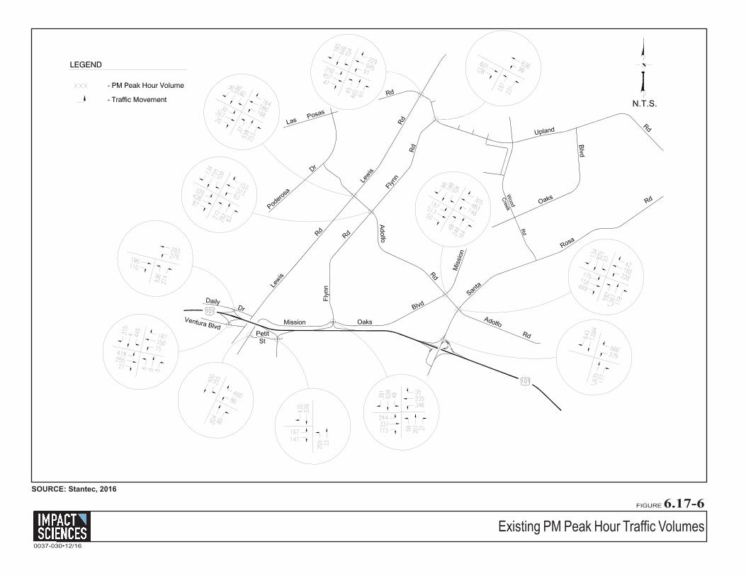
Existing Intersection Levels of Service
Existing levels of service were calculated for the above-mentioned key intersections based on the existing
geometries, traffic control, and the AM and PM peak hour traffic volumes as shown in Figure 6.17-5,
Existing AM Peak-Hour Traffic Volumes, and Figure 6.17-6, Existing PM Peak Hour Traffic Volumes,
respectively. The peak hour traffic volumes were derived from turning-movement counts conducted by
Stantec in June 20166 (see Appendix 6.17). Table 6.17-2, Existing Peak Hour Levels of Service, shows the
existing peak hour level of service for the intersections that were analyzed.
As shown below, in Table 6.17-2, the study-area intersections currently operate within the City’s
acceptable level-of-service range during both peak hours.
Table 6.17-2 Existing Peak Hour Levels of Service
Intersection Traffic Control
AM Peak Hour V/C-LOS
PM Peak Hour V/C-LOS
Upland Rd./Lewis Rd. Signal 0.57/LOS A 0.59/LOS A
Upland Rd./Flynn Rd. Signal 0.55/LOS A 0.45/LOS A
Lewis Rd./Adolfo Rd. Signal 0.69/LOS B 0.68/LOS B
Flynn Rd./Adolfo Rd. Signal 0.61/LOS B 0.68/LOS B
Flynn Rd./US 101 NB Ramps Signal 0.67/LOS B 0.66/LOSA
Adolfo Rd./Mission Oaks Blvd. Signal 0.62/LOS B 0.62/LOS B
Adolfo Rd./Santa Rosa Rd. Signal 0.69/LOS B 0.63/LOS B
Santa Rosa Rd./US 101 NB Ramps Signal 0.65/LOS B 0.70/LOS B
Petit St./Dawson Dr. Signal 0.63/LOS B 0.50/LOS A
Petit St./US 101 SB Ramps All- way stop 12.2 sec/LOS B 13.4 sec/LOS B
Daily Dr./US 101 NB Ramps Signal 0.48/LOS A 0.65/LOS B
Ventura Blvd./US 101 SB Ramps Signal 0.68/LOS B 0.59/LOS A
Sources: Stantec, St. John’s Seminary Residential Project Traffic and Circulation Study, October 3, 2016.
6 Stantec, St. John’s Seminary Residential Project Traffic and Circulation Study, June 21, 2016
UplandRdLas
PosasRd
Lewis
Rd
Lewis
RdW
ood
Rd
Creek
Santa
Rosa
Rd
Plea
sant
Valle
y Rd
Mission Oaks
Blvd
Mis
sion
OaksBlvd
Adolfo
AdolfoRd
Rd
Poder
osa
Dr
Petit St
DailyDr
Ventura Blvd
Flyn
n
Rd
Flynn
Rd
N.T.S.
EXHIBIT 1PROJECT SITE LOCATION/
PROJECT
SITE
PARK
EXISTING STREET NETWORK
Stantec
Page 2
Project Site Location - Existing Street NetworkFIGURE 6.17-4
SOURCE: Stantec, 2016
0037-030•12/16
Existing AM Peak Hour Traffic VolumesFIGURE 6.17-5
Impact Sciences, Inc. 6.17-24 St. John’s Seminary Residential Community EIR 0037.030 June 2017
6.17.6 THRESHOLDS OF SIGNIFICANCE
In order to assist in determining whether a project will have a significant effect on the environment, the
California Environmental Quality Act (CEQA) Statutes and Guidelines, City of Camarillo Threshold
Guidelines (adopted from the State CEQA Guidelines, Appendix G) identify criteria for conditions that
may be deemed to constitute a substantial or potentially substantial adverse change in physical
conditions.
Under the following thresholds, a project may be deemed to have a significant impact if it would:
• Conflict with an applicable plan, ordinance or policy establishing measures of effectiveness for the performance of the circulation system, taking into account all modes of transportation including mass transit and non-motorized travel and relevant components of the circulation system, including but not limited to intersections, streets, highways and freeways, pedestrian and bicycle paths, and mass transit;
• Conflict with an applicable congestion management program, including, but not limited to level of service standards and travel demand measures, or other standards established by the county congestion management agency for designated roads or highways;
• Result in a change in traffic patterns, including either an increase in traffic levels or a change in location that results in substantial safety risks;
• Substantially increase hazards due to a design feature (e.g., sharp curves or dangerous intersections) or incompatible uses (e.g., farm equipment);
• Result in inadequate emergency access;
• Conflict with adopted policies, plans, or programs regarding public transit, bicycle, or pedestrian facilities, or otherwise decrease the performance or safety of such facilities.
City of Camarillo Traffic Impact Thresholds
The City of Camarillo’s acceptable level of service for intersections is LOS C or better, with LOS D (V/C 0.83) allowed for short periods of time during peak hour periods. “Critical movement” refers to the movement or lane for a given phase that requires the most green light time. Project impacts are significant and must be mitigated if they exceed the following thresholds:
• 30 per-lane peak-hour critical movement trips for LOS D
• 20 per-lane peak-hour critical movement trips for LOS E
• 10 per-lane peak-hour critical movement trips for LOS F
6.17 Traffic and Transportation
Impact Sciences, Inc. 6.17-25 St. John’s Seminary Residential Community EIR 0037.030 June 2017
6.17.7 ENVIRONMENTAL IMPACTS
Traffic Model
In addition to existing conditions, the project traffic impact analysis provides a future (without the
proposed project) condition to assess potential impacts generated by approved projects in the vicinity of
the proposed project. Existing plus approved projects traffic forecasts were developed assuming
occupancy of approved development (related) projects in the study area.
Seven (7) approved related projects were identified in the City of Camarillo’s Department of Community
Development Monthly Report (May, 2016), that would add traffic to the study area and are included in
the future conditions analysis. , as shown in Table 6.17-3, Related Projects:
Table 6.17-3 Related Projects
Approved Project Case # Land Use Size RPD-186 Apartment 368 Units
RPD-187 Apartment 82 Units
RPD-188 Condominium 87 Units
RPD-189 Apartment 83 Units
RPD-194 Townhomes 129 Units
CPD-236 Comm. Mixed Use 42,630 SF
UPD-400 Light Industrial 44,186 SF
Source: Stantec, St. John’s Seminary Residential Project Traffic and Circulation Study, October 3, 2016 Note: These projects are the same projects identified in Section 5, and used for the Cumulative Impacts analysis.
In addition, City staff requested that traffic generated by the full development of Camarillo Academy High
School and Performing Arts Center, located west of Lewis Road and north of Las Posas Road, be included in
the future conditions. Trip generation estimates and trip distribution for these two developments were
developed based on data contained in the traffic study prepared for the Camarillo Academy High School and
Performing Arts Center. The approved and pending projects trip generation table is included in the
Technical Appendix of the Traffic Study (Appendix 6.17 of this EIR) for reference.
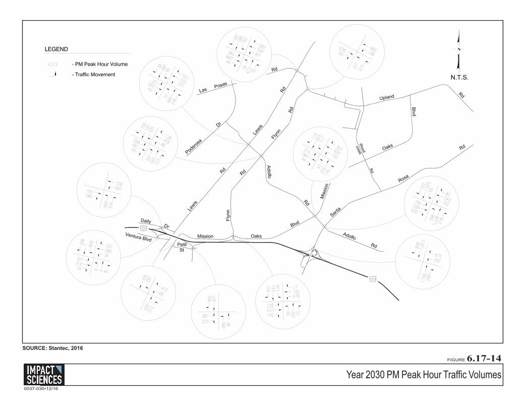
Future Intersection Operations
Levels of service were calculated for the study-area intersections assuming the future baseline AM and
PM peak hour volumes illustrated in Figure 6.17-7, Future Baseline AM Peak-Hour Traffic Volumes
6.17 Traffic and Transportation
Impact Sciences, Inc. 6.17-26 St. John’s Seminary Residential Community EIR 0037.030 June 2017
Impact Sciences, Inc. 6.17-29 St. John’s Seminary Residential Community EIR 0037.030 June 2017
Project Traffic Analysis
Based on the previously listed Thresholds of Significance, the proposed project would have a significant
impact on traffic and transportation if it would:
Conflict with an applicable plan, ordinance or policy establishing measures of effectiveness for the performance of the circulation system, taking into account all modes of transportation including mass transit and non-motorized travel and relevant components of the circulation system, including but not limited to intersections, streets, highways and freeways, pedestrian and bicycle paths, and mass transit
Impacts
Construction
Under the proposed project, temporary traffic impacts may occur during periods when construction
equipment and material or debris is transported to or from the project site. Traffic delays may result from
the presence of additional vehicles on the roadway system, trucks entering or exiting the project site, or
from temporarily reduced lane widths, which may possibly occur on Upland Road. This is a temporary
impact and is not expected to be significant, as the project will be developed over approximately two
years and the truck trips generated (in transporting material on and off the project site) will be distributed
throughout the entire day rather than concentrated during the peak traffic periods.
Construction worker traffic impacts depends on the number of construction workers employed during
various construction phases, as well as the travel mode and travel time of the workers. In general, the
hours of construction typically require workers to be on site before the weekday morning commuter peak
period and allow them to leave before or after the afternoon commuter peak period. Therefore, most, if
not all, of the construction worker trips would occur outside of the typical weekday commuter peak
periods.
Therefore, impacts to traffic and circulation would be less than significant during the construction phases
of the proposed project.
Operation
Trip Generation Rates
Trip generation rates developed by the City for residential land uses were applied to estimate trips
generated by the proposed senior citizen housing development. Active adult dwellings are expected to
6.17 Traffic and Transportation
Impact Sciences, Inc. 6.17-30 St. John’s Seminary Residential Community EIR 0037.030 June 2017
generate less traffic than single family dwellings, because trips associated with single family dwellings
such as children related trips (school, sports etc.) or work commute trips would occur less frequent. The
City has not developed trip generation rated for active adult dwellings, and no rates are available in
recognized trip generation handbooks (Institute of Transportation Engineers’ Trip Generation Manual or
SANDAG’s Traffic Generators). Based on City staff input, rates were developed by interpolating between
the City’s trip generation rates for Single Family Residential and Retirement Community. Trip generation
rates are summarized in Table 6.17-5, Project Trip Generation Rates.
Table 6.17-5 Project Trip Generation Rates
Land Use Unit Daily Rate AM Peak Hour Rates PM Peak Hour Rates In Out Total In Out Total
Senior Citizen Housing DU 6.5 0.10 0.42 0.52 0.33 0.18 0.51 DU – Dwelling unit Source: Stantec, St. John’s Seminary Residential Project Traffic and Circulation Study, October 3, 2016
The trip generation estimates of the proposed project are shown in Table 6.17-6, Project Trip Generation
Estimates.
Table 6.17-6 Project Trip Generation Estimates
Land Use Size ADT AM Peak Hour Rates PM Peak Hour Rates
In Out Total In Out Total Estate 320 DU 2,080 32 134 166 106 57 163 DU – Dwelling unit Source: Stantec, St. John’s Seminary Residential Project Traffic and Circulation Study, October 3, 2016
The proposed project, as shown in Table 6.17-6, is expected to generate 2,080 average daily trips, with 166
trips occurring during the AM peak hour and 163 trips occurring during the PM peak hour.
Trip Distribution
The trip distribution pattern for the residential component is expected to be regional in nature. Trip
distribution percentages were developed separately for the project site based on existing traffic patterns;
the location of the residential, commercial, and industrial areas within the Camarillo area; and knowledge
of the regional demographics. Table 6.17-7, Project Trip Distribution, shows the project trip distribution
percentages, and Figure 6.17-9, Project Trip Distribution, shows the residential site distribution
percentages. Project-generated traffic was distributed and assigned to the study-area street network
according to the percentages shown below in Table 6.17-7.
6.17 Traffic and Transportation
Impact Sciences, Inc. 6.17-31 St. John’s Seminary Residential Community EIR 0037.030 June 2017
Table 6.17-7 Project Trip Distribution
Street Direction Percentage of Trips US Highway 101 North/South 21 percent/28 percent
Las Posas Road West 25 percent
Lewis Road North/South 4 percent/5 percent
Santa Rosa Road Northeast 5 percent
Pleasant Valley Road South 1 percent
Ventura Boulevard Southwest 2 percent
Daily Drive Southwest 1 percent
Local -- 8 percent
Total Traffic 100 percent Source: Stantec, St. John’s Seminary Residential Project Traffic and Circulation Study, October 3, 2016 Notes: E/O = East Of W/O = West Of
Project Trip DistributionFIGURE 6.17-9
SOURCE: Stantec, 2016
0037-030•12/16
Project Added Traffic VolumesFIGURE 6.17-10
SOURCE: Stantec, 2016
0037-030•12/16
6.17 Traffic and Transportation
Impact Sciences, Inc. 6.17-34 St. John’s Seminary Residential Community EIR 0037.030 June 2017
The proposed project-added traffic was added to the future traffic volumes. Figure 6.17-10, Project
Added Traffic Volumes, shows the project-added traffic volumes for the proposed project.
Levels of service for the study-area intersections were recalculated based on the future-plus-project traffic
volumes. Figure 6.17-11, Future plus Project AM Peak Hour Traffic Volumes, and Figure 6.17-12 Future
plus Project PM Peak Hour Traffic Volumes show the anticipated traffic volumes for each intersection.
Table 6.17-8, Future plus Project AM Peak Hour Intersection Levels of Service and Table 6.17-9, Future
plus Project PM Peak Hour Intersection Levels of Service, show the level of service analysis results for
the AM and PM peak hours, respectively.
Table 6.17-8 Future plus Project AM Peak Hour Intersection Levels of Service
Intersection Future Baseline
LOS Future + Project
LOS Impact
Upland Road/Lewis Road 0.60/LOS A 0.62/LOS B No
Upland Road/Flynn Road 0.55/LOS A 0.59/LOS A No
Lewis Road/Adolfo Road 0.70/LOS B 0.70/LOS B No
Flynn Road/Adolfo Road 0.63/LOS B 0.65/LOS B No
Flynn Road/US 101 NB Ramps 0.69/LOS B 0.69/LOS B No
Adolfo Road/Mission Oaks Blvd. 0.63/LOS B 0.63/LOS B No
Adolfo Road/Santa Rosa Road 0.69/LOS B 0.69/LOS B No
Santa Rosa Road/US 101 NB Ramps 0.65/LOS B 0.66/LOS B No
Petit Street/Dawson Road 0.67/LOS B 0.68/LOS B No
Petit Street/US 101 SB Ramps1 0.55/LOS A 0.56/LOS A No
Daily Drive/US 101 NB Ramps 0.51/LOS A 0.51/LOS A No
Ventura Blvd./US 101 SB Ramps 0.72/LOS C 0.72/LOS C No
Source: Stantec, St. John’s Seminary Residential Project Traffic and Circulation Study, October 3, 2016
Future plus Project AM Peak Hour Traffic VolumesFIGURE 6.17-11
SOURCE: Stantec, 2016
0037-030•12/16
Future plus Project PM Peak Hour Traffic VolumesFIGURE 6.17-12
SOURCE: Stantec, 2016
0037-030•12/16
6.17 Traffic and Transportation
Impact Sciences, Inc. 6.17-37 St. John’s Seminary Residential Community EIR 0037.030 June 2017
Table 6.17-9 Future plus Project PM Peak Hour Intersection Levels of Service
Intersection Future Baseline
LOS Future +
Project LOS Impact? Upland Road/Lewis Road 0.61/LOS B 0.61/LOS B No
Upland Road/Flynn Road 0.46/LOS A 0.49/LOS A No
Lewis Road/Adolfo Road 0.68/LOS B 0.69/LOS B No
Flynn Road/Adolfo Road 0.69/LOS B 0.70/LOS B No
Flynn Road/US 101 NB Ramps 0.71/LOS C 0.72/LOS C No
Adolfo Road/Mission Oaks Blvd. 0.62/LOS B 0.62/LOS B No
Adolfo Road/Santa Rosa Road 0.63/LOS B 0.63/LOS B No
Santa Rosa Road/US 101 NB Ramps 0.70/LOS B 0.70/LOS B No
Petit Street/Dawson Road 0.57/LOS A 0.58/LOS A No
Petit Street/US 101 SB Ramps1 0.54/LOS A 0.54/LOS A No
Daily Drive/US 101 NB Ramps 0.71/LOS C 0.71/LOS C No
Ventura Blvd./US 101 SB Ramps 0.62/LOS B 0.62/LOS B No
Source: Stantec, St. John’s Seminary Residential Project Traffic and Circulation Study, October 3, 2016
The level-of-service data shown above in Table 6.17-8 indicates the study area intersections would
continue to operate at LOS C or better under the proposed project. The proposed project upon
implementation will not generate any significant project-specific intersection impacts during the AM
peak hour.
As shown above in Table 6.17-9, the study-area intersections under the proposed land use concept would
operate at LOS C circulation conditions or better under future-plus-project conditions during PM peak
hour circulation, which is acceptable based on the City of Camarillo’s LOS C standard. The proposed
project would therefore not generate any significant project-specific impacts during PM peak hour
circulation.
The proposed project will also be subject to the City of Camarillo Traffic Mitigation Impact Fee
Ordinance, as discussed above.7 Since the proposed project is located within District 2 of the Traffic
Mitigation Impact Fee program, the proposed project will be required to pay into the fund, the
appropriate impact fees for District 2. Paying into this Traffic Mitigation Impact Fee program will provide
funding for the City of Camarillo to complete improvements to intersections and roadways throughout
the City.
Therefore, implementation of the proposed project would not conflict with the City’s measures of
effectiveness for the performance of the circulation system, and impacts would be less than significant.
7 City of Camarillo Municipal Code, Title 11 Vehicles and Traffic, Chapter 11.68 “Traffic Impact Mitigation Fees”
6.17 Traffic and Transportation
Impact Sciences, Inc. 6.17-38 St. John’s Seminary Residential Community EIR 0037.030 June 2017
Mitigation Measures
No mitigation measures are required.
Residual Impacts
Impacts would be less than significant.
Conflict with an applicable congestion management program, including, but not limited to level of service standards and travel demand measures, or other standards established by the county congestion management agency for designated roads or highways
Impacts
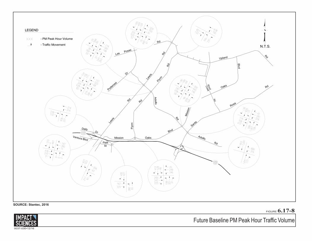
For the purposes of a Congestion Management Program (CMP) traffic impact analysis, LOS E is
considered to be acceptable, and a significant impact occurs if the proposed project increases traffic
demand on a CMP facility by 2% of capacity (V/C > 0.02), causing or worsening LOS F (V/C > 1.00).
Roadways: U.S. 101, Lewis Road, Las Posas Road, and Santa Rosa Road are included in the CMP
network. According to the 2009 CMP8, all facilities operate at LOS D or better during the AM and PM
peak hours periods except the following segments of U.S. 101:
• Southbound U.S. 101 south of Lewis Road operates in the LOS F range during the AM peak hour.
The proposed project would add 9 AM peak hour trips (PHT). These traffic additions would not
result in a CMP impact based on the criteria outlined above.
• Northbound U.S. 101 operates in the LOS F range during the PM peak hour. The project would
add 12 PM PHT. These additions would not result in a CMP impact based on the criteria outline
above.
Additionally, within the study area the Lewis Road/Las Posas Road intersection and Santa Rosa
Road/U.S. 101 Interchange are included in the CMP network. These intersections are forecasted to operate
at LOS C or better.
As discussed above, the proposed project would not contribute to a significant increase in traffic levels on
the studied roadway segments or intersections as analyzed in the traffic study. The proposed project will
contain its own circulation system within its boundaries, consisting of local residential streets and 8 2009 Ventura County Congestion Management Program, VCTC, Adopted July 10, 2009.
6.17 Traffic and Transportation
Impact Sciences, Inc. 6.17-39 St. John’s Seminary Residential Community EIR 0037.030 June 2017
collector streets that will be connected to the circulation system of the City of Camarillo via Upland Road.
The proposed project will not include or be required to provide any improvements to the local circulation
system of the City of Camarillo outside the proposed project’s boundaries. Therefore, since the proposed
project under the three concepts will not conflict with CMP congestion control measures at any CMP
intersection.
Mitigation Measures
No mitigation is required.
Residual Impacts
Impacts would be less than significant.
Result in a change in traffic patterns, including either an increase in traffic levels or a change in location that results in substantial safety risks
The proposed project would construct internal streets to provide access for project residents, but would
not require alteration of existing public streets. As discussed above, the proposed project would not result
in substantial traffic increases such that significant decreases in intersection levels of service would occur.
Since the proposed project would not alter intersection operation, no changes in traffic patterns are
expected to result from project development, and impacts would be less than significant.
Mitigation Measures
No mitigation is required.
Residual Impacts
Impacts would be less than significant.
Substantially increase hazards due to a design feature (e.g., sharp curves or dangerous intersections) or incompatible uses (e.g., farm equipment)
Impacts
The proposed project will include the development of an internal circulation system that will consist of a
two-lane roadway extending from Upland Road and several local streets that will provide access to the
various residential clusters within the proposed project boundaries. All local streets will be developed in
accordance with the City of Camarillo street development standards and will also be consistent in width
6.17 Traffic and Transportation
Impact Sciences, Inc. 6.17-40 St. John’s Seminary Residential Community EIR 0037.030 June 2017
and design with the City’s standards. Therefore, the internal circulation system within the proposed
project will not develop local streets that will include design features that could increase hazards;
therefore, impacts would be less than significant.
The proposed project will also include the development of an intersection that will provide access onto
the residential portion of the project site (a driveway along Upland Road that will be shared by the Padre
Serra Parish). It is possible that this intersection could provide less than acceptable line-of-sight
conditions for residents’ ingress and egress onto and off of the project site from Upland Road. However, a
sight distance analysis was conducted for the proposed driveway to the residential portion of the
proposed project along Upland Road. The analysis indicated that the proposed driveway would be
designed in a way that would provide corner sight lines in excess of the required 500-foot distance in
both directions for residents entering the proposed project site and leaving the proposed project site
(residential portion) and entering Upland Road.
Therefore, since the proposed project would not substantially increase hazards due to a design feature or
incompatible uses, impacts would be less than significant.
Mitigation Measures
No mitigation is required.
Residual Impacts
Impacts would be less than significant.
Result in inadequate emergency access.
Impacts
Access to the proposed residential development would be provided via a new full-access driveway
connection to Upland Road located immediately west of the Padre Serra Parish. The adjacent existing
right-turn-only driveway that provides access to the church would be eliminated, and traffic from the
church lot would utilize the new full-access driveway. Frontage improvements on Upland Road would
include construction of an eastbound turn-lane bay and a westbound right-turn deceleration lane at the
proposed intersection. The recommended length of the westbound right-turn lane is 275 feet, including
taper. This is based on the deceleration requirements contained in the Highway Design Manual and
assumes partial deceleration in the westbound through lane to 35 mph.
6.17 Traffic and Transportation
Impact Sciences, Inc. 6.17-41 St. John’s Seminary Residential Community EIR 0037.030 June 2017
The operations of the new driveway were analyzed in the traffic report based on the proposed
intersection geometry and the existing-plus-project and General Plan buildout-plus-project volumes.
Traffic volumes counted at the exiting church driveway were also incorporated. The access point would
contain two inbound lanes, of which the right lane would trap into the church parking lot, and separate
outbound turning lanes. The intersection will be controlled by a stop sign on the proposed project site
driveway.
The analysis within the traffic report indicates that the driveway would operate in the LOS B range
overall and LOS C or better on the minor street during both the AM and PM peak hours. Traffic volumes
at the access driveway are expected to increase during short periods of time immediately before and after
church-related activities at the Padre Serra Parish. Since these periods would not coincide with commute
travel times, the access intersection to the proposed project is expected to continue to operate at
acceptable LOS levels.
A traffic signal warrant analysis was completed for the proposed access intersection for the proposed
project (refer to Appendix 6.17).
The signal warrant analysis indicates that the unsignalized intersection of Upland Road and the project
driveway would operate acceptably under existing-plus-project and General Plan buildout-plus-project
conditions. Since warrants are not likely to be met based on project traffic alone, installation of a traffic
signal is not required. Because of potential traffic fluctuations associated with church activities, traffic
conditions may be monitored and traffic signal warrants completed after buildout of the proposed project
to evaluate the need for a traffic signal at the driveway entrance under project traffic plus church traffic
conditions. Therefore, impacts would be less than significant.
Emergency Site Access
The emergency access point to the proposed residential community would be provided via the existing
St. John’s Seminary access roadway, which extends from Upland Road, and would connect to the
proposed project site’s circulation system on the project site’s northeast boundary. The existing roadway
is 23 to 26 feet wide. A truck-turning analysis was conducted in the traffic report (refer to Appendix 6.17),
which indicated that the driveway would accommodate a fire truck without encroaching into the
opposing travel lane.
6.17 Traffic and Transportation
Impact Sciences, Inc. 6.17-42 St. John’s Seminary Residential Community EIR 0037.030 June 2017
Under the St. John’s Seminary Road Emergency Access Route the proposed project would be required to
incorporate the following amenities to provide the proper type of emergency access road, according to
the City of Camarillo and Ventura County Fire Department Guidelines:9
• A gate would be provided at the Doheny Library that would serve as the emergency access point onto the proposed project site. The gate would need to automatically open and have a fail-safe power system and signage indicating that this route was for emergency purposes only. Residents of the proposed project would be allowed to exit only through this gate, but the Ventura County Fire Department would have full ingress and egress to the proposed project through this gate.
• Another gate has been considered acceptable by the Ventura County Fire Department at the T-intersection of the seminary road that goes south to the Major Seminary campus or north to the seminary college; or, instead of a gate, the access road should provide signage to direct traffic.
• “No Parking-Fire Lane” signs will need to be posted along the entire emergency access road through the St. John’s Seminary property.
• The St. John’s Seminary Road Emergency Access Route will need to meet the Ventura County Fire Department’s standard turning radius space of 40 feet.
The Ventura County Fire Department reviewed and approved the St. John’s Seminary Road Emergency
Access Route in July 2015. Therefore, the proposed project would provide adequate emergency access
routes for egress and ingress onto the proposed project. As a result, impacts would be less than
significant.
Mitigation Measures
No mitigation is required. Residual Impacts
Impacts would be less than significant.
Conflict with adopted policies, plans or programs supporting alternative transportation (e.g., bus turnouts, bicycle racks).
Impacts
The proposed project will provide for areas of trails that will connect pocket parks and view parks to
various residential clusters within the proposed project. This will allow residents to walk, bike, or jog to
parks within the proposed project boundaries, instead of use their vehicles to travel to the parks from
9 Notes from Meeting between the Ventura County Fire Department (at the Fire Department), John Dodd, Glen
Pace, Dave Lauletta, Jasch Janowicz, and Jackie Lee, December 3, 2008.
6.17 Traffic and Transportation
Impact Sciences, Inc. 6.17-43 St. John’s Seminary Residential Community EIR 0037.030 June 2017
their residence. Additionally, Upland Road to the south of the proposed project includes bicycle lanes
that future residents of the proposed project will be able to access and use.
The proposed project does not include the development of bus turnouts. However, the closest transit bus
stop (Camarillo Area Transit – CAT) to the proposed project is located approximately 0.75 mile to the
west of the proposed project along East Los Posas Road in front of the Camarillo Library.
Furthermore, bike lane and sidewalk connections will be provided from the site’s internal circulation
system to Upland Road, as the roadway is fully developed with Class II bike lanes. On-site circulation
system will be designed pursuant to City of Camarillo collector roadway and residential roadway
standards to accommodate all travel modes. Therefore, since the proposed project will not conflict with
adopted policies, plans, or programs supporting alternative transportation, impacts would be less than
significant.
Mitigation Measures
No mitigation is required.
Residual Impacts
Impacts would be less than significant.
6.17.8 CUMULATIVE ANALYSIS
Exceed, either individually or cumulatively, a level of service standard established by the County congestion management agency for designated roads or highways.
Buildout (Cumulative) Traffic Forecasts
Buildout traffic volumes for the study-area intersections were derived from the City’s Traffic Model
(CTAM) and were provided by City staff. The Traffic Model’s Year 2030 traffic forecasts include both
traffic growth associated with buildout of the City’s Land Use Element and anticipated regional growth,
and incorporates the roadway network improvements included in the City’s Circulation Element. In
addition, traffic from the Camarillo Academy High School and Performing Arts Center – Buildout Scenario was
added to the City’s CTAM forecasts.
Figure 6.17-13, Year 2030 AM Peak Hour Traffic Volumes, and Figure 6.17-14, Year 2030 PM Peak Hour
Traffic Volumes, show the cumulative AM and PM peak hour traffic volumes that are expected upon
buildout of the City of Camarillo.
6.17 Traffic and Transportation
Impact Sciences, Inc. 6.17-44 St. John’s Seminary Residential Community EIR 0037.030 June 2017
Buildout (Cumulative) Intersection Levels of Service
Buildout of the City of Camarillo General Plan will result in an increase in traffic flows to the local
circulation system within the City. In order to determine the impact that the proposed project would have
on cumulative intersection level of service for the studied intersections, the project-added AM and PM
peak hour traffic volumes for each land use concept were layered onto the General Plan buildout
peak-hour traffic volumes as shown in Figure 6.17-14, Buildout Plus Project AM Peak Hour Traffic
Volumes Figure 6.17-15 and Figure 6.17-24, Buildout Plus Project PM Peak Hour Traffic. Additionally,
the level of service calculations are shown in Table 6.17-10, AM Buildout Plus Project Intersection
Levels of Service, and Table 6.17-11, PM Buildout Plus Project Intersection Levels of Service.
Year 2030 AM Peak Hour Traffic VolumesFIGURE 6.17-13
SOURCE: Stantec, 2016
0037-030•12/16
Year 2030 PM Peak Hour Traffic VolumesFIGURE 6.17-14
SOURCE: Stantec, 2016
0037-030•12/16
N.T.S.
UplandRd
Las Posas
Rd
Lewis
Rd
Lewis
Rd
Wood
Rd
creek
Santa
Rosa
Rd
Mission Oaks
Blvd
Mis
sion
Oaks
Blvd
Adolfo
AdolfoRd
Rd
Podero
sa
Dr
PetitSt
DailyDr
Ventura Blvd
Flyn
n
Rd
Flynn
Rd
EXHIBIT 14
LEGEND
- Traffic Movement
- AM Peak Hour Volume
YEAR 2030 + PROJECT AM PEAK HOUR TRAFFIC VOLUMES
Stantec
25
Year 2030 plus Project AM Peak Hour Traffic VolumesFIGURE 6.17-15
SOURCE: Stantec, 2016
0037-030•12/16
Year 2030 plus Project PM Peak Hour Traffic VolumesFIGURE 6.17-16
SOURCE: Stantec, 2016
0037-030•12/16
6.17 Traffic and Transportation
Impact Sciences, Inc. 6.17-49 St. John’s Seminary Residential Community EIR 0037.030 June 2017
Table 6.17-10 indicates that one intersection is forecast to operate below the City’s LOS C standard during
the AM peak hour under buildout and Buildout plus project conditions. The intersection of Adolfo Road
and Santa Rosa Road would operate in the LOS D range. The project would not exceed the LOS D
threshold of the addition of 30 per lane peak hour critical movement trips. The project would therefore
not generate any buildout intersection impacts during the AM peak hour. It is noted that brief periods of
LOS D (V/C 0.83) during AM and PM peak hours are permitted where improvements to achieve LOS C
would be unreasonably costly.
Table 6.17-10 AM Buildout Plus Project Intersection Levels of Service
Intersection
AM Peak Hour Buildout
LOS Buildout + Project
LOS Impact? Upland Road/Lewis Road 0.61/LOS B 0.62/LOS B No
Upland Road/Flynn Road 0.45/LOS A 0.48/LOS A No
Lewis Road/Adolfo Road 0.69/LOS B 0.69/LOS B No
Flynn Road/Adolfo Road 0.59/LOS A 0.61/LOS B No
Flynn Road/US 101 NB Ramps 0.78/LOS C 0.79/LOS C No
Adolfo Road/Mission Oaks Blvd. 0.69/LOS B 0.69/LOS B No
Adolfo Road/Santa Rosa Road 0.81/LOS D 0.81/LOS D No
Santa Rosa Road/US 101 NB Ramps 0.74/LOS C 0.74/LOS C No
Petit Street/Dawson Drive 0.62/LOS B 0.63/LOS B No
Petit Street/US 101 SB Ramps 0.55/LOS A 0.56/LOS A No
Daily Drive/US 101 NB Ramps 0.49/LOS A 0.49/LOS A No
Ventura Blvd./US 101 SB Ramps 0.80/LOS C 0.80/LOS C No Source: Stantec, St. John’s Seminary Residential Project Traffic and Circulation Study, October 3, 2016 NB = Northbound; SB = Southbound
Table 6.17-11 PM Buildout Plus Project Intersection Levels of Service
Intersection
PM Peak Hour
Buildout LOS Buildout + Project
LOS Impact? Upland Road/Lewis Road 0.65/LOS B 0.65/LOS B No
Upland Road/Flynn Road 0.53/LOS A 0.57/LOS A No
Lewis Road/Adolfo Road 0.70/LOS B 0.71/LOS C No
Flynn Road/Adolfo Road 0.68/LOS B 0.69/LOS B No
Flynn Road/US 101 NB Ramps 0.65/LOS B 0.66/LOS B No
Adolfo Road/Mission Oaks Blvd. 0.62/LOS B 0.62/LOS B No
Adolfo Road/Santa Rosa Road 0.63/LOS B 0.63/LOS B No
Santa Rosa Road/US 101 NB Ramps 0.72/LOS C 0.72/LOS C No
Petit Street/Dawson Drive 0.57/LOS A 0.58/LOS A No
Petit Street/US 101 SB Ramps1 0.72/LOS C 0.73/LOS C No
Daily Drive/US 101 NB Ramps 0.72/LOS C 0.73/LOS C No
6.17 Traffic and Transportation
Impact Sciences, Inc. 6.17-50 St. John’s Seminary Residential Community EIR 0037.030 June 2017
Intersection
PM Peak Hour
Buildout LOS Buildout + Project
LOS Impact? Ventura Blvd./US 101 SB Ramps 0.62/LOS B 0.62/LOS B No
Source: Stantec, St. John’s Seminary Residential Project Traffic and Circulation Study, October 3, 2016 NB = Northbound; SB = Southbound
As shown above in Table 6.17-11, the level of service indicates that all intersections are forecast to operate
at the City’s LOS C standard or better during the PM peak hour under buildout and buildout plus project
conditions.
As discussed above, the General Plan buildout (cumulative) and proposed project analysis shows that the
proposed project would not exceed any of the City of Camarillo’s impact thresholds during the AM and
PM peak hour under General Plan buildout conditions. While the intersection of Adolfo Road and Santa
Rosa road would operate at LOS D during the AM peak hour, the proposed project would not increase
the intersection’s v/c ratio beyond the level caused by cumulative development. Therefore, the proposed
project would not cumulatively contribute to the traffic impacts upon General Plan buildout; thus, the
project would be considered cumulatively less than significant.
Mitigation Measures
No mitigation is required.
Residual Impacts
Impacts would be less than significant impact.
6.17.9 CONSISTENCY WITH THE GENERAL PLAN
The City of Camarillo General Plan Circulation Element provides the following goals and policies for
traffic and transportation that apply to the proposed project. An analysis of the consistency of the
proposed project with each of the general plan goals, objectives, and policies is provided below.
Goal: Promote a well-balanced, connected, economically feasible, and sustainable multimodal
transportation system that provides for a safe and efficient movement on well-maintained
roads while meeting the needs of Camarillo residents, businesses, employees, visitors, special
needs populations, and the elderly.
Analysis: The proposed project will be located in an area within the City of Camarillo, where its
residents will have access to the Camarillo Area Transit (CAT) fixed route bus service, through the
6.17 Traffic and Transportation
Impact Sciences, Inc. 6.17-51 St. John’s Seminary Residential Community EIR 0037.030 June 2017
location of a bus stop approximately 0.75 mile to the west of the proposed project site. Residents of the
proposed project site will have access to the bus stop, via Upland Road to East Los Posas Road. Since the
proposed project will be located in an area of the City that encourages the use of City transit systems,
including the CAT and Dial-a-Ride bus service, and will provide a convenient location for residents of the
proposed project to access the CAT, the proposed project will be consistent with this goal.
Goal: Provide adequate parking that is attractive, convenient, efficient, and appropriate in capacity
without overshadowing the uses which the parking supports.
Analysis: Parking for the St. John’s Seminary Residential Community Project is proposed in six
“parking areas”. Parking for the single family units occurs in three parking areas. Parking in area 1
includes 52 garage spaces and 50 guest spaces; 102 total parking spaces. Parking in area 3 includes 24
garage spaces and 27 guest spaces; 51 total parking spaces, while parking in area 6 includes 52 garage
spaces and 39 guest spaces; 91 total parking spaces. The proposed project will be consistent with this goal.
Goal: Maintain a safe and efficient public transportation network that provides mobility to all city
residents and employees as an alternative to automobile travel.
Analysis: The proposed project will be located in an area within the City of Camarillo, where its
residents will have access to the Camarillo Area Transit (CAT) fixed route bus service, through the
location of a bus stop approximately 0.75 mile to the west of the proposed project site. Residents of the
proposed project site will have access to the bus stop, via Upland Road to East Los Posas Road. Since the
proposed project will be located in an area of the City that encourages the use of City transit systems,
including the CAT and Dial-a-Ride bus service, and will provide a convenient location for residents of the
proposed project to access the CAT, the proposed project will be consistent with this goal.
CONSISTENCY ANALYSIS SUMMARY
The proposed project is consistent with the City of Camarillo General Plan and there would be no impact.