37


Ú×ÙËÎÛ
ï

Table 1: Analytical Data for Groundwater
DSCA ID No.: 63-0005
Chl
orof
orm
cis-
1,2-
Dic
hlor
oeth
ylen
e
Ethy
lben
zene
Nap
htha
lene
Tetra
chlo
roet
hyle
ne
Tolu
ene
Tric
hlor
oeth
ylen
e
Xyl
enes
(tot
al)
Ace
tone
2-B
utan
one
MW-1 10/12/06 <0.005 <0.005 <0.005 <0.005 <0.005 <0.005 <0.005 <0.0010 <0.100 <0.010
MW-1 4/4/07 <0.005 <0.005 <0.005 <0.005 <0.005 <0.005 <0.005 <0.005 <0.010 <0.010
MW-1 4/17/08 0.00062J <0.005 <0.005 0.00054J 0.00055J <0.005 <0.005 <0.005 <0.1 <0.010
MW-2 10/11/06 <0.005 <0.005 <0.005 <0.005 <0.005 <0.005 <0.005 <0.0010 <0.100 <0.010
MW-2 4/4/07 <0.005 <0.005 <0.005 <0.005 <0.005 <0.005 <0.005 <0.005 0.049 <0.01
MW-2 10/17/07 0.00053J 0.006 <0.005 <0.005 0.001 <0.005 0.0023J <0.005 <0.010 <0.010
MW-2 2/7/08 0.0044J <0.005 0.0075J 0.041 <0.0007 0.0046J <0.005 0.0071J <0.01 0.0019J
MW-3 10/11/06 0.016 <0.005 <0.005 <0.005 <0.005 <0.005 <0.005 <0.0010 <0.100 <0.010
MW-3 4/4/07 <0.005 0.0059 <0.005 <0.005 <0.005 <0.005 <0.005 <0.005 <0.010 <0.01
MW-3 10/17/07 0.00044J 0.0038J <0.005 <0.005 <0.0007 <0.005 <0.005 <0.005 <0.010 <0.010
MW-3 2/7/08 0.0011J 0.01 0.0027J 0.0062 0.0022 <0.005 0.0044J 0.00219J <0.010 <0.010
MW-4 10/11/06 <0.005 <0.005 <0.005 <0.005 <0.005 <0.005 <0.005 <0.0010 <0.100 <0.010
MW-4 4/4/07 <0.005 <0.005 <0.005 <0.005 <0.005 <0.005 <0.005 <0.005 <0.010 <0.01
MW-4 10/17/07 <0.005 <0.005 <0.005 <0.005 <0.0007 <0.005 <0.005 <0.005 <0.010 <0.010
MW-4 2/7/08 0.0044J 0.0032J <0.005 0.0023J 0.00058J <0.005 0.0012J 0.00131J <0.010 0.0019J
0.07 0.07 0.55 0.021 0.0007 1 0.0028 0.53 0.7 NENC 2L Standard
Gro
undw
ater
Sam
plin
g Po
int
Sam
plin
g D
ate
(mm
/dd/
yy)
[mg/L]

PCE Concentration vs. Time
0
0.01
0.02
0.03
0.04
0.05
0.06
0.07
7/2/06 10/10/06 1/18/07 4/28/07 8/6/07 11/14/07 2/22/08 6/1/08
Date
Con
cent
ratio
n (m
g/L)
MW-1MW-2MW-3MW-4
RBSL Protective of Groundwater Use Levelfor PCE (0.0651 mg/L)
Unrestrictive UseLevel (2L)
for PCE (0.0007 mg/L)

Trichloroethylene Concentration vs. Time
0
0.05
0.1
0.15
0.2
0.25
0.3
7/2/06 10/10/06 1/18/07 4/28/07 8/6/07 11/14/07 2/22/08 6/1/08
Date
Con
cent
ratio
n (m
g/L)
MW-1MW-2MW-3MW-4
RBSL Protective of Groundwater Use Level
for Trichloroethylene (0.26 mg/L)
Unrestrictive UseLevel (2L)
for Trichloroethylene (0.0028 mg/L)
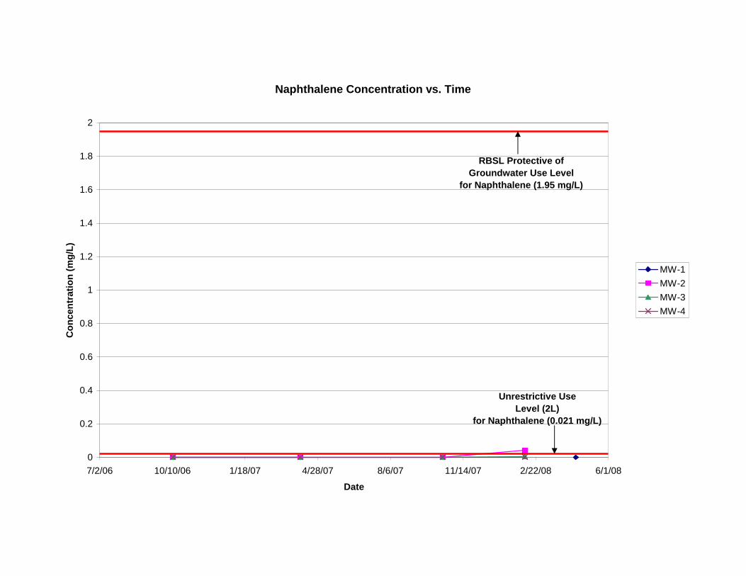
Naphthalene Concentration vs. Time
0
0.2
0.4
0.6
0.8
1
1.2
1.4
1.6
1.8
2
7/2/06 10/10/06 1/18/07 4/28/07 8/6/07 11/14/07 2/22/08 6/1/08
Date
Con
cent
ratio
n (m
g/L)
MW-1MW-2MW-3MW-4
RBSL Protective of Groundwater Use Level
for Naphthalene (1.95 mg/L)
Unrestrictive UseLevel (2L)
for Naphthalene (0.021 mg/L)


Appendix A Ecological Risk Assessment – Level 1 Dry Cleaners Express 1930 N. Poplar Street Southern Pines, Moore County, NC ATC Project No: 45.34341.6305 DSCA Site ID: 63-0005 Checklist A 1. Are there navigable water bodies or tributaries to a navigable water body on or within the
one-half mile of the site?
Based on the Southern Pines Quadrangle United States Geological Survey (USGS) Topographic Map, the nearest mapped surface water body is an intermittent stream located approximately 1,000 feet southeast of the site. However, based on a review of aerial photographs and visual observations, ATC found that a pond associated with the headwaters of the stream is located approximately 400 feet southeast of the site. The intermittent stream drains to Bear Ford Swamp then ultimately into Aberdeen Creek. See the topographic map in Attachment 1 and the United States Fish and Wildlife Service (USFWS) Ecomap in Attachment 2.
2. Are there any water bodies anywhere on or within the one-half mile of the site?
Based on the USGS topographic map, surface water bodies within one-half mile of the site include the above referenced intermittent stream, another intermittent stream located approximately 2,000 feet to the southeast, and two ponds located 2,300 feet to the northeast and 2,300 feet to the east.
3. Are there any wetland areas such as marshes or swamps on or within one-half mile of the
site? Based on the USFWS, two small ponds located approximately 2,300 feet northeast and east
of the site are classified as wetland areas. In addition, wetland areas are located adjacent to Bear Creek Swamp near the one-half mile radius to the southeast.
4. Are there any sensitive environmental areas on or within one-half mile of the site? Based on a review of the USFWS online database and the North Carolina Heritage, no
critical habitats or significant natural areas are located within one-half mile of the site. 5. Are there any areas on or within one-half mile of the site owned or used by local tribes? Based on site observations and historical research, no tribal artifacts or lands have been
identified on or within one-half mile of the site.

6. Are there any habitat, foraging area or refuge by rare, threatened, endangered, candidate and/or proposed species (plants or animals), or any otherwise protected species on or within one-half of the site?
Based on the USFWS online databases, there are no wilderness areas or wildlife refuges
within one-half mile of the site. 7. Are there any breeding, roosting or feeding areas by migratory bird species on or within one-
half of the site? The Migratory Bird Treaty Act was developed to help reduce potential migratory bird strikes
with aircraft, wind turbines and towers. Many species of birds are protected that are common to the United States, Canada, and Mexico. Therefore, many species of birds in Moore County (e.g., Bald Eagle, Canadian Goose, Mourning Dove) are likely to be within one-half mile of the site.
8. Are there any ecologically, recreationally, or commercially important species on or within
one-half mile of the site? Based on site observations and desktop review, ecologically important species could
potentially be located in the woodland area and surface water areas located east and southeast of the site.
9. Are there any threatened and/or endangered species (plant or animal) on or within one-half
mile of the site? ATC reviewed the USFWS online species list. The following species were identified within
Moore County:
• Notropis mekistocholas – Capre Fear Shiner: Endangered • Picoides borealis – Red-cockaded Woodpecker: Endangered • Schwalbea Americana – American Chaffseed: Endangered • Rhus michauxii – Michaux’s Sumac: Endangered
ATC also reviewed the North Carolina Heritage online Southern Pines Quadrangle species
list. The following species were identified:
• Eupatorium resinosum – Pine Barren Boneset: Threatened-Special Concern • Lilium pyrophilum – Sandhills Lily: Endangered- Special Concern • Pyxidanthera barbulata var. brevifolia – Sandhills Pyxie-moss: Endangered • Picoides borealis – Red-cockaded Woodpecker: Endangered

Checklist B 1A. Can chemicals associated with the site leach, dissolve, or otherwise migrate to groundwater? Yes. The primary constituents of concern are tetrachloroethylene (PCE), trichloroethylene
(TCE), and naphthalene. Based on published references [Environmental Protection Agency (EPA) and United States Agency for Toxic Substances and Disease Registry (ATSDR)], PCE and TCE are leachable to groundwater and soluble in groundwater. Napthalene has a lower solubility, but still may leach and dissolve in groundwater. Furthermore, impacted groundwater has been confirmed at the site.
1B. Are chemicals associated with the site mobile in groundwater?
Yes. Chemical mobility is primarily influenced by the chemical solubility and soil-water partition coefficient (Fetter, 1988). Based on these values, the mobility class of PCE and TCE is considered moderate and the mobility class of naphthalene is considered low.
1C. Does groundwater from the site discharge to an ecological receptor habitat?
The primary ecological receptor habitats identified in the site vicinity are the surface water features located 400 to 3,000 feet southeast of the site. However, the plume has been fully defined and does not extend off the site property. As such, the impacted groundwater does not appear likely to discharge to these ecological receptor habitats.
1. Could chemicals associated with the site reach ecological receptors through
groundwater?
No. As discussed above, the plume is confined to the site property and does not appear likely to reach the nearest ecological receptor habitats.
2A. Are chemicals present in surface soils on the site?
Yes. Surficial soils have been impacted at the site. PCE has been detected at concentrations ranging from of 0.0016 to 0.0237 milligrams per kilogram (mg/kg) in surfical soil. Note that these concentrations are less than the lowest Tier 1 Risk-Based Screening Level (RBSL) established by DSCA of 0.034 mg/kg.
2B. Can chemicals be leached from or be transported by erosion of surface soil on the site?
Yes. Based on the groundwater data collected to date and published references, the chemicals can be leached from the soil. However, it should be noted that the area of surficial soil impact is located beneath a paved area or the building. As such, the extent of leaching is likely minimized. No. The surficial soils impacted at the site are located beneath the existing building and a paved area. As such, severe erosion and transport of impacted surficial soils from the site does not appear likely.

2. Could chemicals associated with the site reach ecological receptors through runoff or erosion?
No. Low concentrations of PCE have been identified in surficial soil, but the soil is located in an area where runoff or erosion appears unlikely.
3A. Are chemicals present in the surface soil or on the surface of the ground? Yes. Impacted surficial soils have been documented at the site.
3B. Are potential ecological receptors on the site.
No. The site property is an active shopping center with paved surface cover and no surface water features. As such, ecological receptors are unlikely to be present on the site property.
3. Could chemicals associated with the site reach ecological receptors through direct
contact?
No. Surficial impacted soil has been identified, but is located below paved areas or the on-site building and ecological receptors are unlikely to be present in the area.
4A. Are chemicals on the site volatile? Yes. Chlorinated solvents are considered volatile organic compounds. 4B. Could chemicals on the site be transported in air as dust or particulate matter?
No. The area of impacted soil is located beneath a paved area or the on-site building, so erosion as dust or particulate matter appears unlikely.
4. Could chemicals associated with the site reach ecological receptors through inhalation of volatilized chemicals or adhered chemicals to dust in ambient air or in subsurface burrows?
No. As discussed above, erosion of impacted soils or significant volatilization from impacted soils appears unlikely due to the surface cover (paving or building) located over the impacted soil.
5A. Is Non-Aqueous Phase Liquid (NAPL) present at the site? No. NAPL has not been encountered at the site. 5B. Is NAPL migrating? No. NAPL has not been encountered at the site. 5C. Could NAPL discharge occur where ecological receptors are found?

No. NAPL has not been encountered at the site. 5. Could chemicals associated with the site reach ecological receptors through migration
of NAPL? No. NAPL has not been encountered at the site. 6A. Are chemicals present in surface and shallow subsurface soils or on the surface of the
ground? Yes. Impacted surficial soils have been documented at the site.
6B. Are chemicals found in the soil on the site taken up by plants growing on the site? No. The area of surficial soil impact is located beneath asphalt pavement or the on-site building and plants are not growing in the area.
6C. Do potential ecological receptors on or near the site feed on plants (e.g., grasses, shrubs, forbs, trees, etc.) found on the site?
No. There is no significant vegetation growing in the area of impacted soil, so feeding by ecological receptors is unlikely
6D. Do chemicals found on the site bioaccumulate? No. Based on published references (ATSDR and EPA), PCE, TCE, and naphthalene do not
significantly bioaccumulate. 6. Could chemicals associated with the site reach ecological receptors through direct
ingestion of soil, plants, animals, or contaminants? No. Based on the low contaminant concentrations in surficial soils, surface cover over
the area of impacted soil, commercial site environment, and absence of bioaccumulation for the chemicals of concern, it is not anticipated that chemicals associated with the site would reach ecological receptors through direct ingestion of soil, plants, animals, or contaminants.
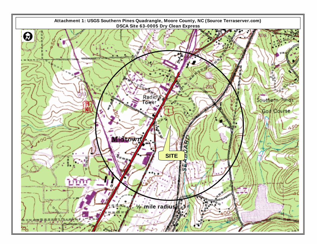
Attachment 1: USGS Southern Pines Quadrangle, Moore County, NC (Source Terraserver.com)DSCA Site 63-0005 Dry Clean Express
SITE
½ mile radius

Attachment 2: USFWS Ecomap, Southern Pines Quadrangle, Moore County, NCDSCA Site: 63-0005 Dry Clean Express
½ mile radius
SITE


Property Owner: Derby Investment Company, LLC
Recorded in Book ____, Page ____ Associated plat recorded in Plat Book ____, Page ____
NOTICE OF DRY-CLEANING SOLVENT REMEDIATION
This documentary component of a Notice of Dry-Cleaning Solvent Remedation (NDCSR or Notice), as well as the plat component, have been filed this _____ day of __________________, 200__ by Derby Investment Company, LLC (hereinafter “Property Owner”). The Notice concerns contaminated property.
A copy of this Notice certified by the North Carolina Department of Environment and Natural Resources, or its successor in function (hereinafter “DENR”) is required to be filed in the Register of Deeds’ Office in the county or counties in which the land is located, pursuant to North Carolina General Statutes (hereinafter “NCGS”), Section (hereinafter “§”) 143-215.104M.
This Notice is required by NCGS § 143-215.104M in order to reduce or eliminate the danger to public health or the environment posed by environmental contamination at a property (hereinafter the “DSCA Site”) being addressed under the Dry-Cleaning Solvent Cleanup Act of 1997, Article 21A, Part 6 NCGS § 143-215.104A et seq, (hereinafter “DSCA”).
Pursuant to NCGS § 143-215.104M, a certified copy of this Notice must be filed within 15 days of receipt of DENR’s approval of the Notice or the effective date of the dry-cleaning solvent remediation agreement, whichever is later. Pursuant to NCGS § 143-215.104M, the copy of the Notice certified by DENR must be recorded in the grantor index under the names of the owners of the land.
The DSCA Site is located at 1930 North Poplar Street, Southern Pines, Moore County, North Carolina and is approximately 8.46 acres in size. The DSCA Site has been used as a retail dry-cleaning facility from 1987 to December 1997. Soil and groundwater are contaminated with dry-cleaning solvents.
Attached hereto as Exhibit A is a reduction, to 8 1/2" x 11", of the survey plat required by NCGS § 143-215.104M. It is a plat that has been prepared and certified by a professional land surveyor and that meets the requirements of NCGS § 47-30. That plat contains the following information:
(1) The location and dimensions of the areas of potential environmental concern with respect to permanently surveyed benchmarks; and
(2) The type, location and quantity of regulated substances and contaminants known to exist on the DSCA Site.
Attached hereto as Exhibit B is a legal description of the DSCA Site that would be sufficient as a
description of the property in an instrument of conveyance.
LAND USE RESTRICTIONS NCGS § 143-215.104M also requires that the Notice identify any restrictions on the current and future use of the DSCA Site that are necessary or useful to maintain the level of protection appropriate for the designated

current or future use of the DSCA Site and that are designated in the dry-cleaning remediation agreement. The restrictions shall remain in force in perpetuity unless canceled by the Secretary of DENR (or its successor in function), or his/her designee, after the hazards have been eliminated, pursuant to NCGS §143-215104M. Those restrictions are hereby imposed on the DSCA Site, and are as follows: 1. The DSCA Site shall be used exclusively for commercial or industrial purposes and related amenities (parking, landscape areas and walkways), and all other uses of the DSCA site are prohibited except as approved in writing by DENR. 2. Without prior written approval from DENR, the DSCA Site shall not be used for:
a. child care centers, schools, parks, recreational areas, athletic fields or sporting activities of any kind;
b. agricultural or grazing purposes or for timber production; c. kennels, private animal pens, or for riding clubs; d. mining or extraction of coal, oil, gas or any other mineral or non-mineral
substances.
3. Surface water and underground water at the DSCA Site may not be used for any purpose without the approval of DENR. 4. No activities that encounter, expose, remove or use groundwater (for example, installation of water supply wells, fountains, ponds, lakes or swimming pools that use groundwater, or construction or excavation activities that encounter or expose groundwater) may occur on the DSCA Site without prior sampling and analysis of groundwater to the satisfaction of DENR in any areas proposed for such activities, and submittal of the analytical results to DENR. If such results disclose to DENR contamination in excess of North Carolina’s groundwater quality standards, the proposed activities may not occur without the approval of DENR on such conditions as DENR imposes, including at a minimum compliance with plans and procedures, approved pursuant to applicable law, to protect public health and the environment during the proposed activities. 5. In January of each year, on or before January 31st, the owner of any portion of the DSCA Site shall submit a notarized Annual DSCA Land Use Restrictions Certification to DENR certifying that this Notice remains recorded at the Moore County Register of Deeds’ office, that the Land Use Restrictions are being complied with. 6. No person conducting environmental assessment or remediation at the Site, or involved in determining compliance with applicable land use restrictions, at the direction of, or pursuant to a permit or order issued by DENR may be denied access to the DSCA Site for the purpose of conducting such activities. 7. The owner of any portion of the DSCA Site shall cause the instrument of any sale, lease, grant, or other transfer of any interest in the property to include a provision expressly requiring the lessee, grantee, or transferee to comply with this Notice. The failure to include such a provision shall not affect the validity or applicability of any land use restriction in this Notice.
EASEMENT (RIGHT OF ENTRY)
The property owner grants and conveys to the Department, its agents, contractors, and employees, and any person performing pollution remediation activities under the direction of the Department, access at reasonable times and under reasonable security requirements to the Property to determine and monitor compliance with the Risk Management Plan and the land use restrictions set forth in this NDCSR. Such investigations and actions are necessary by the Department to ensure that use, occupancy, and activities of and at the Property are consistent with the land use restrictions and to ensure that the structural integrity and continued effectiveness of any engineering controls (if appropriate) described in the NDCSR are maintained. Whenever possible, at least 48 hours of advanced notice will be given to the property owner prior to entry. Advanced notice may not always be possible due to conditions such as response time to complaints and emergency situations.
ENFORCEMENT
The above land use restrictions shall be enforceable without regard to lack of privity of estate or contract, lack of benefit to particular land, or lack of any property interest in particular land. The land use restrictions shall be enforced by any owner of the DSCA Site. The land use restrictions may also be enforced by DENR through the remedies provided in NCGS § 143-215.104P or by means of a civil action; by any unit of local government having jurisdiction over any part of the DSCA Site; and by any person eligible for liability protection under the DSCA who will lose liability protection if the restrictions are violated. Any attempt to cancel any or all of this Declaration without the approval of the Secretary of DENR (or its successor in function), or his/her delegate, shall be subject to enforcement by DENR to the full extent of the law. Failure by any party required or authorized to enforce any of the above restrictions shall in no event be deemed a waiver of the right to do so thereafter as to the same violation or as to one occurring prior or subsequent thereto.
If a land-use restriction set out in a NDCSR required under NCGS § 143-215.104.M is violated, the owner of the contamination site at the time the land-use restriction is violated, the owner’s successors and assigns, and the owner’s agents who direct or contract for alteration of the contamination site in violation of a land-use restriction shall be liable for remediation of all contaminants to unrestricted use standards.
FUTURE SALES, LEASES, CONVEYANCES AND TRANSFERS
When any portion of the DSCA Site is sold, leased, conveyed or transferred, pursuant to NCGS § 143-215.104M the deed or other instrument of transfer shall contain in the description section, in no smaller type than that used in the body of the deed or instrument, a statement that the DSCA Site has been contaminated with dry-cleaning solvent and, if appropriate, cleaned up under the DSCA.
The Property Owner shall notify the Division at least fourteen (14) calendar days before the effective date of any conveyance, grant, gift, or other transfer, whole or in part, of the Owner’s interest in the property. This notice shall include the name, business address and phone number of the transferee and the expected date of transfer.

GENERAL PROVISIONS
The Property Owner shall notify the Division within thirty (30) days following the Owner’s petitioning for or filing of any document initiating a rezoning of the Property that would change the base zone of the Property.
CANCELLATION OF NDSCR
A NDSCR may, at the request of the Property Owner, be canceled by the Division after the risk to public health and the environment associated with the dry-cleaning solvent contamination and any other contaminants included in the DSCA Remediation Agreement have been eliminated as a result of remediation of the Property to unrestricted use standards.

OWNER SIGNATURE
IN WITNESS WHEREOF, Property Owner has caused this instrument to be duly executed this
_____ day of _______________, 200__.
Derby Investment Company, LLC
By: ______________________________
name of contact
STATE OF ______________ ______________ COUNTY I, _________________________, a Notary Public of the county and state aforesaid, certify that ______________ personally came before me this day and acknowledged that he is a Member of Derby Investment Company, LLC, a ______________ limited liability corporation, and its Manager, and that by authority duly given and as the act of the company, the foregoing Notice of Dry-Cleaning Solvent Remediation was signed in its name by him. WITNESS my hand and official stamp or seal, this _____ day of _______________, 200_. _____________________________________________ Name typed or printed: Notary Public My Commission expires: ___________________ [Stamp/Seal]
APPROVAL AND CERTIFICATION OF NORTH CAROLINA DEPARTMENT OF ENVIRONMENT AND NATURAL RESOURCES
The foregoing Notice of Dry-Cleaning Solvent Remediation is hereby approved and certified. North Carolina Department of Environment and Natural Resources By: _________________________________________ ________________________
Jack Butler, Chief Date Superfund Section Division of Waste Management

LIMITED POWER OF ATTORNEY I _________________________________________“Property Owner”, do hereby grant a limited power of attorney to the Division and to the Division’s independent contractors, as follows: The Division and the Division’s independent contractors shall have the limited power of
attorney to record this Notice, including its documentary and survey plat components, in
accordance with N.C.G.S. § 143-215.104M on my “Property Owner” behalf. This limited
power of attorney shall terminate upon completion of the recordation of the Notice.
Signature of Property Owner ____________ ______________ Dated this _____day of ___ ___, 20___. STATE OF ____________________ COUNTY OF ____________________ I, ____________________________________, a Notary Public, do hereby certify that
_________________________________________ personally appeared before me this day and
signed this Limited Power of Attorney”.
WITNESS my hand and official seal this _ __ day of ______ ___, 20 __. _________________________________________
Notary Public
My Commission expires: ___________________
[SEAL]
CERTIFICATION OF REGISTER OF DEEDS The foregoing documentary component of the Notice of Dry-Cleaning Solvent Remediation, and the associated plat, are certified to be duly recorded at the date and time, and in the Books and Pages, shown on the first page hereof. Register of Deeds for Moore County By: ________________________________________ _______________________ Name typed or printed: ___________________________ Date Deputy/Assistant Register of Deeds


EXHIBIT B
LEGAL DESCRIPTION FOR PROPERTY

Site Name: Dry Clean Express Site Address: 1930 N. Poplar Street, Southern Pines, Moore County, NC DSCA ID No: 63-0005
ANNUAL DSCA LAND USE RESTRICTIONS CERTIFICIATION Pursuant to Land Use Restriction Number ______ in a Notice of Dry-Cleaning Solvent Remediation (NDCSR) executed by ___________________ and recorded on __________________ at the Moore County Register of Deeds Office, Derby Investment Company, LLC hereby certifies, as an owner of at least part of the property that is the subject of the NDCSR, that the NDCSR remains recorded at the Moore County Register of Deeds office and the land use restrictions therein are being complied with. Duly executed this _____ day of _______________, 200_. Derby Investment Company, LLC By: Name typed or printed: Member/Manager STATE OF _____________ _____________ COUNTY I, _________________________, a Notary Public of the county and state aforesaid, certify that _____________________ personally came before me this day and acknowledged that he/she is a Member of Derby Investment Company, LLC, a _____________________ limited liability corporation, and its Manager, and that by authority duly given and as the act of the corporation, the foregoing certification was signed in its name by him/her. WITNESS my hand and official stamp or seal, this _____ day of _______________, 200_. _____________________________________________ Name typed or printed: Notary Public My Commission expires: ___________________ [Stamp/Seal]


