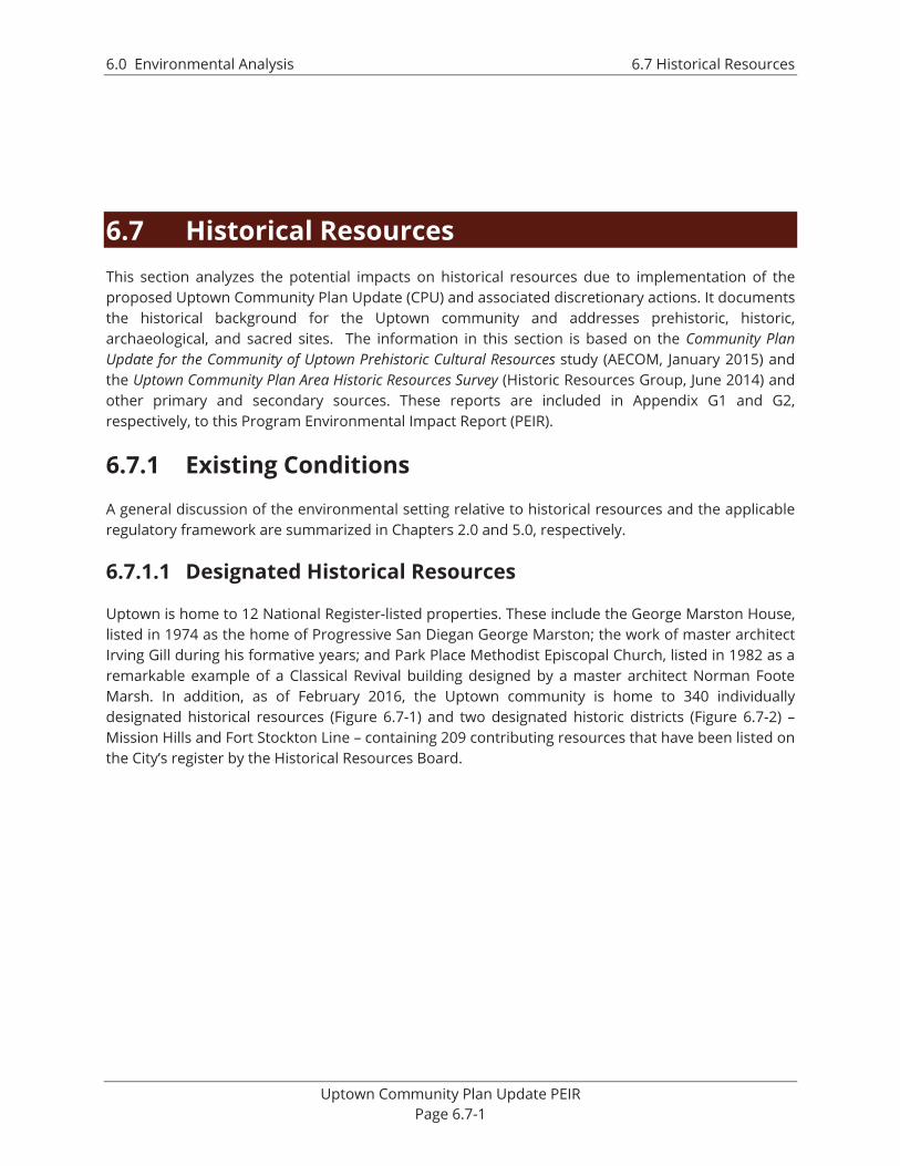
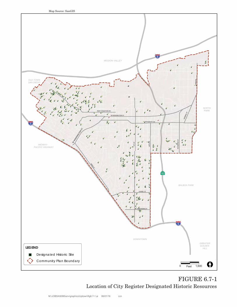
6.0 Environmental Analysis 6.7 Historical Resources Uptown Community Plan Update PEIR Page 6.7-1 6.7 Historical Resources This section analyzes the potential impacts on historical resources due to implementation of the proposed Uptown Community Plan Update (CPU) and associated discretionary actions. It documents the historical background for the Uptown community and addresses prehistoric, historic, archaeological, and sacred sites. The information in this section is based on the Community Plan Update for the Community of Uptown Prehistoric Cultural Resources study (AECOM, January 2015) and the Uptown Community Plan Area Historic Resources Survey (Historic Resources Group, June 2014) and other primary and secondary sources. These reports are included in Appendix G1 and G2, respectively, to this Program Environmental Impact Report (PEIR). 6.7.1 Existing Conditions A general discussion of the environmental setting relative to historical resources and the applicable regulatory framework are summarized in Chapters 2.0 and 5.0, respectively. 6.7.1.1 Designated Historical Resources Uptown is home to 12 National Register-listed properties. These include the George Marston House, listed in 1974 as the home of Progressive San Diegan George Marston; the work of master architect Irving Gill during his formative years; and Park Place Methodist Episcopal Church, listed in 1982 as a remarkable example of a Classical Revival building designed by a master architect Norman Foote Marsh. In addition, as of February 2016, the Uptown community is home to 340 individually designated historical resources (Figure 6.7-1) and two designated historic districts (Figure 6.7-2) – Mission Hills and Fort Stockton Line – containing 209 contributing resources that have been listed on the City’s register by the Historical Resources Board.
6.7 Historical Resources This section analyzes the potential impacts on historical resources due to implementation of the proposed Uptown Community Plan Update (CPU) and associated discretionary actions. It documents the historical background for the Uptown community and addresses prehistoric, historic, archaeological, and sacred sites. The information in this section is based on the Community Plan Update for the Community of Uptown Prehistoric Cultural Resources study (AECOM, January 2015) and the Uptown Community Plan Area Historic Resources Survey (Historic Resources Group, June 2014) and other primary and secondary sources. These reports are included in Appendix G1 and G2, respectively, to this Program Environmental Impact Report (PEIR).
6.7.1 Existing Conditions
A general discussion of the environmental setting relative to historical resources and the applicable regulatory framework are summarized in Chapters 2.0 and 5.0, respectively.
6.7.1.1 Designated Historical Resources
Uptown is home to 12 National Register-listed properties. These include the George Marston House, listed in 1974 as the home of Progressive San Diegan George Marston; the work of master architect Irving Gill during his formative years; and Park Place Methodist Episcopal Church, listed in 1982 as a remarkable example of a Classical Revival building designed by a master architect Norman Foote Marsh. In addition, as of February 2016, the Uptown community is home to 340 individually designated historical resources (Figure 6.7-1) and two designated historic districts (Figure 6.7-2) – Mission Hills and Fort Stockton Line – containing 209 contributing resources that have been listed on the City’s register by the Historical Resources Board.
W W
ASHIN
GTON S
T
BALBOA PARK
GREATERGOLDEN
HILL
NORTHPARK
OLD TOWNSAN DIEGO
DOWNTOWN
MISSION VALLEY
MIDWAY- PACIFIC HIGHWAY
!"_$
!"̂$
AgH
!"̂$
INDIA ST
PAR
K B
L
06TH
AV
W WASHINGTON ST
UNIVERSITY AV
RICH
MO
ND
ST
NORM
AL S
T
LAUREL ST
FORT STOCKTON DR
HAWTHORN ST
1ST
AV
LEGEND
") Designated Historic Site
Community Plan BoundaryCopyright 2012 SanGIS - All Rights Reserved. Full text of this legalnotice can be found at http://www.sangis.org/Legal_Notice.htm
o
FIGURE 6.7-1Location of City Register Designated Historic Resources
Map Source: SanGIS
W W
ASHIN
GTON S
T
BALBOA PARK
GREATERGOLDEN
HILL
NORTHPARK
OLD TOWNSAN DIEGO
DOWNTOWN
MISSION VALLEY
MIDWAY- PACIFIC HIGHWAY
!"_$
!"̂$
AgH
!"̂$
INDIA ST
PAR
K B
L
06TH
AV
W WASHINGTON ST
UNIVERSITY AV
RICH
MO
ND
ST
NORM
AL S
T
LAUREL ST
FORT STOCKTON DR
HAWTHORN ST
1ST
AV
LEGEND
Historic District Boundary
Community Plan BoundaryCopyright 2012 SanGIS - All Rights Reserved. Full text of this legalnotice can be found at http://www sangis org/Legal Notice htm
o
FIGURE 6.7-2Location of City Register Designated Historic District
A Prehistoric Cultural Resources Study and a Historic Resources Survey were prepared for the proposed Uptown CPU and associated discretionary actions. The Cultural Resources Study describes the pre-history of the Uptown area, identifies known significant archaeological resources, provides guidance on the identification of possible new significant archaeological resources, and includes recommendations for the treatment of significant archaeological resources. The Historic Resources Survey provides information regarding the significant historical themes in the development of Uptown, the property types that convey those themes in an important way, and the location of potential historical resources within the community, including individual resources, multiple property listings, and districts.
6.7.2.1 Prehistoric Resources
Cultural sensitivity levels for the Uptown Community Plan area are rated low, moderate, or high based on the results of an archival records search using the California Historical Resources Information System (CHRIS), a literature search at the South Coastal Information Center (SCIC) located a San Diego State University, a records update at the San Diego Museum of Man, a Sacred Lands File check by the Native American Heritage Commission (NAHC), and regional environmental factors.
A low sensitivity rating indicates that there are few or no previously recorded resources within the area. Resources at this level would not be expected to be complex, with little to no site structure or artifact diversity. The potential for identification of additional resources in such areas would be low. A moderate sensitivity rating indicates that some previously recorded resources were identified within the area. These are more complex resources consisting of more site structure, diversity of feature types, and diversity of artifact types. The potential for the presence of additional resources in such areas would be moderate. Areas identified as high sensitivity would indicate that the records search identified several previously recorded sites within the area. These resources may range from moderately complex to highly complex, with more-defined living areas or specialized work space areas, and a large breadth of features and artifact assemblages. The potential for identification of additional resources in such areas would be high. Sensitivity ratings may be adjusted based on the amount of disturbance that has occurred, which may have previously impacted archaeological resources.
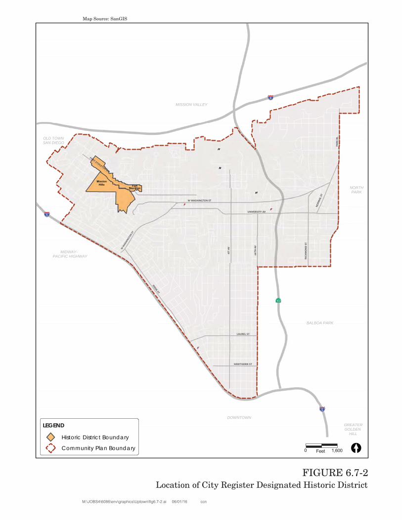
Because the majority of the community is developed and there is very little undeveloped land within the Community Plan area, with the exception of canyon areas, the cultural sensitivity for the entire Uptown community is considered low due to steepness of the canyon slopes. However, at the base of these canyons, especially leading into the Mission Valley area, there is a potential for cultural resources to be present; therefore, the cultural sensitivity rating for these areas is considered high, specifically when in proximity to the San Diego Presidio and areas bordering Old Town. As such, the community of Uptown contains two sensitivity ratings as illustrated in Figure 6.7-3.
FIGURE 6.7-3Cultural Sensitivity Areas – Prehistoric Resources
The Historic Resources Survey was conducted using a four-step approach, which included research, fieldwork, evaluation, and documentation. The research phase involved review of various relevant City documents (municipal codes and regulations, planning reports, previous historic resources surveys, and various historic nominations), as well as various historical materials (period newspaper articles, photographs, maps).
The fieldwork phase consisted of a property-by-property inspection of the entire Community Plan area. Field teams identified individual properties that appeared eligible for individual designation, as well as geographically definable areas that appeared eligible for designation as historic districts. For districts, boundaries were defined and contributing and non-contributing resources were identified.
All properties identified in the field as potentially eligible for designation were then evaluated using the City of San Diego local designation criteria. Properties determined potentially eligible for designation on the City's Register were then evaluated for the National Register and California Register. All properties identified and evaluated as potentially eligible for listing on the San Diego Register, California Register, and/or National Register designation as part of this survey were then documented in a database.
Included as an appendix to the Historic Resources Survey is the Historic Context Statement prepared for the Uptown community. The Historic Context Statement was developed primarily through archival research. It synthesizes information collected from a variety of primary and secondary materials. In addition to consulting the historical resource files at the City Planning and Community Investment Department and the archives at Save Our Heritage Organisation, research was conducted at the San Diego Public Library, the San Diego Historical Society, and the libraries at the University of California, San Diego. Primary sources included historic maps, photographs and newspapers, and media advertisements. Specifically, subdivision maps, in conjunction with Sanborn Fire Insurance Maps, were used to establish broad patterns of development within Uptown. Historic photographs provided imagery of the community’s evolving landscape and predominant architectural styles. Other primary materials included several articles, advertisements, and editorials from the archives of the Los Angeles Times and San Diego Union. Secondary sources of information were consulted to supplement these primary materials, and included later accounts of history recorded in a variety of books, essays, journals, and master’s theses.
6.7.3 Significance Determination Thresholds
Historical resources significance determination, pursuant to the City of San Diego’s Significance Determination Thresholds, consists first of determining the sensitivity or significance of identified historical resources and, secondly, determining direct and indirect impacts that would result from project implementation. Based on the City’s 2011 Significance Determination Thresholds, which have been adopted to guide a programmatic assessment of the proposed Uptown CPU and associated discretionary actions, impacts related to historical resources would be significant if the project would result in:
1) An alteration, including the adverse physical or aesthetic effects and/or the destruction of a historic building (including an architecturally significant building), structure, object or site; or
2) A substantial adverse change in the significance of a prehistoric archaeological resource, a religious or sacred use site, or the disturbance of any human remains, including those interred outside of formal cemeteries.
The City of San Diego’s California Environmental Quality Act (CEQA) Significance Determination Thresholds define a significant historical resource as one which qualifies for the California Register of Historical Resources or is listed in a local historic register or deemed significant in a historical resource survey, as provided under Section 5024.1(g) of the Public Resources Code, although even a resource that is not listed in, or determined eligible for listing in, the California Register, not included in a local register, or not deemed significant in a historical resource survey may nonetheless be historically significant for purposes of CEQA. The City’s Historical Resources Guidelines state the significance of a resource may be determined based on the potential for the resource to address important research questions as documented in a site-specific technical report prepared as part of the environmental review process.
Research priorities for the prehistoric, ethnohistoric, and historic periods of San Diego history are discussed in Appendix A to the City’s Historical Resources Guidelines. As a baseline, the City of San Diego has established the following criteria to be used in the determination of significance under CEQA:
An archaeological site must consist of at least three associated artifacts/ecofacts (within a 50 square meter area) or a single feature and must be at least 45 years of age. Archaeological sites containing only a surface component are generally considered not significant, unless demonstrated otherwise. Such site types may include isolated finds, bedrock milling stations, sparse lithic scatters, and shellfish processing stations. All other archaeological sites are considered potentially significant. The determination of significance is based on a number of factors specific to a particular site including site size, type and integrity; presence or absence of a subsurface deposit, soil stratigraphy, features, diagnostics, and datable material; artifact and ecofact density; assemblage complexity; cultural affiliation; association with an important person or event; and ethnic importance.
The determination of significance for historic buildings, structures, objects and landscapes is based on age, location, context, association with an important person or event, uniqueness, and integrity.
A site will be considered to possess ethnic significance if it is associated with a burial or cemetery; religious social or traditional activities of a discrete ethnic population; an important person or event as defined by a discrete ethnic population; or the mythology of a discrete ethnic population.
Would implementation of the proposed Uptown CPU and associated discretionary actions result in an alteration, including the adverse physical or aesthetic effects and/or the destruction of a historic building (including an architecturally significant building), structure, object, or site?
a. Individual Local Historic Resources
Of the 11,104 properties surveyed in 2004–2006, the survey identified 2,192 properties as potentially significant individual resources, 59 of which are also located in Potential Historic Districts. The resources identified can be found in the Uptown Community Plan Area Historic Resources Survey (Appendix G2). Of the resources identified as potentially significant individual resources, approximately 56 percent are single-family properties, 35 percent are multi-family properties, eight percent are commercial properties, and one percent are institutional properties. Thematically, the potentially significant individual resources are distributed as follows:
The Railroad Boom and Early Residential Development: 1885 to1909: 12 percent
The Panama-California Exposition and Streetcar Suburbs: 1909 to1929: 44 percent
Great Depression and World War II: 1929 to 1948: 21.5 percent
Postwar Development, Suburbanization, the Automobile, and Modernism: 1948 to 1970: 22 percent
Neighborhood Revitalization and the Lesbian, Gay, Bisexual, and Transgender (LGBT) Community: 1970 to Present: 0 percent * (*The 2004 to 2006 survey only evaluated properties constructed prior to 1961.)
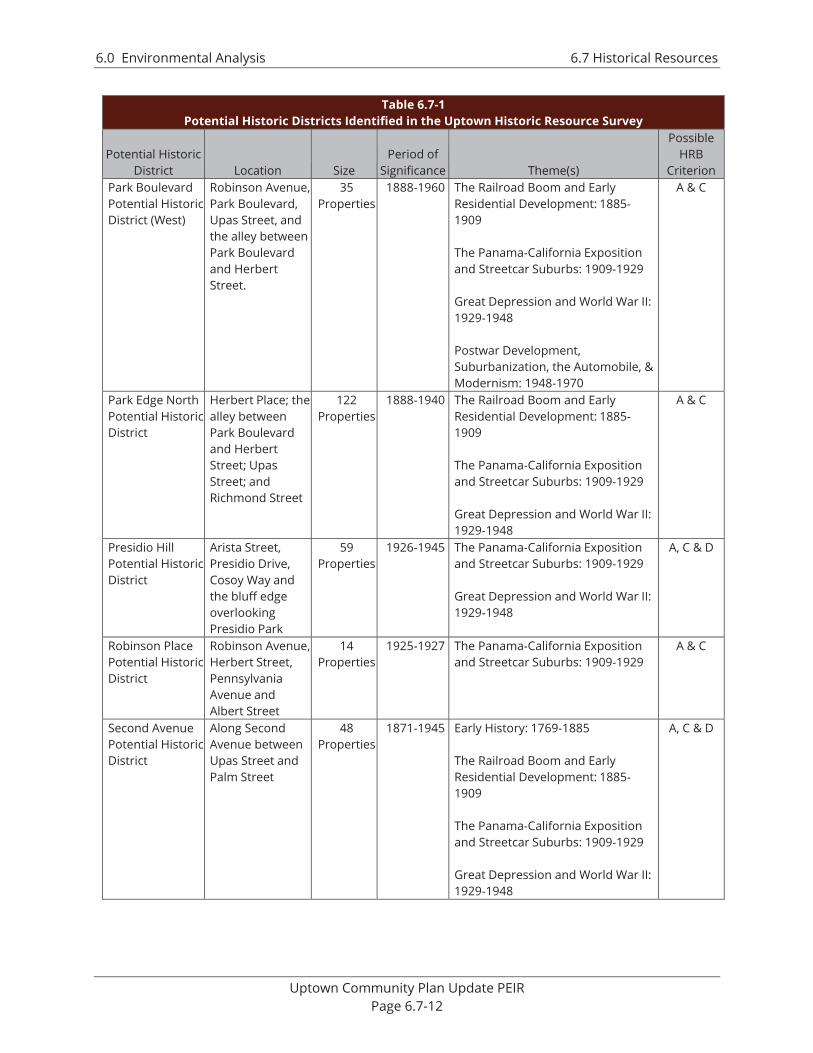
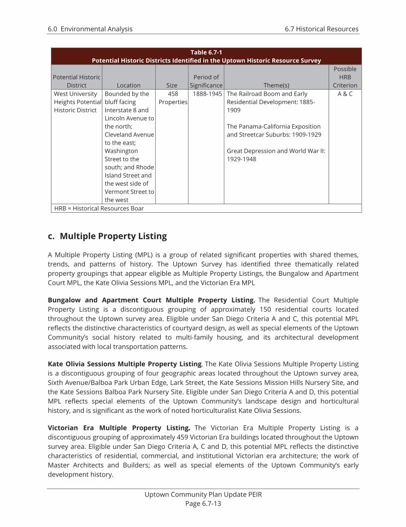
b. Potential Historic Districts Identified in the Historic Resources Survey
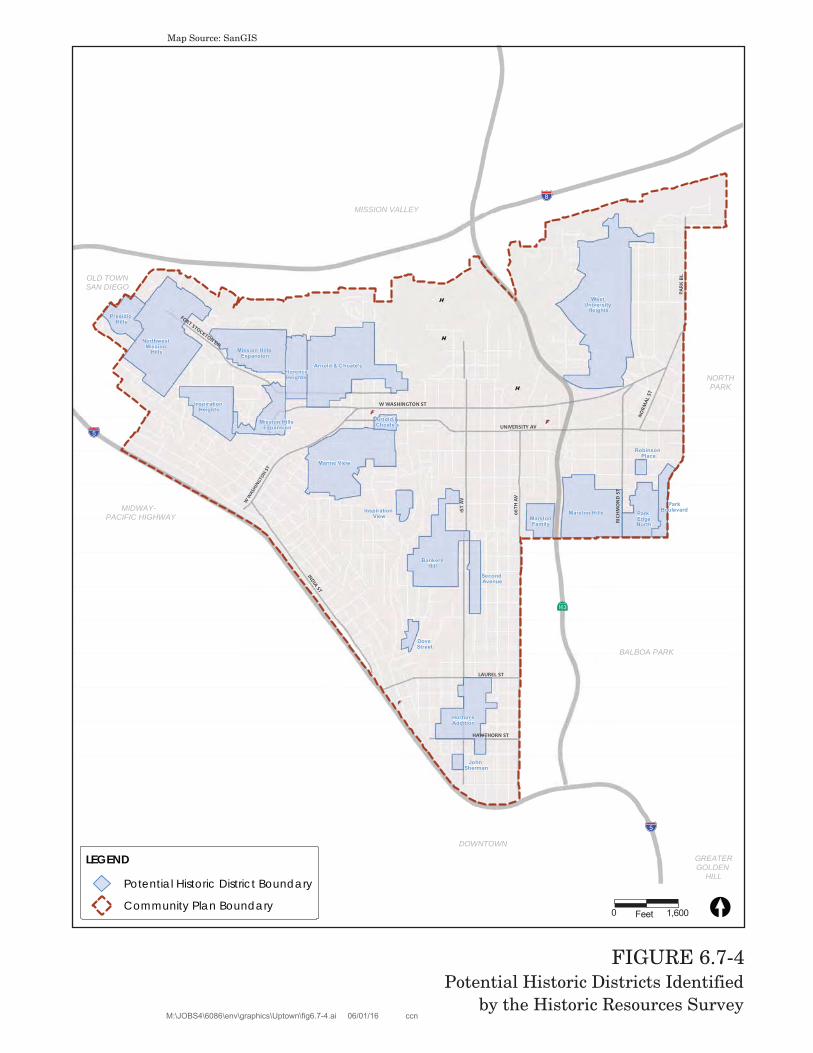
The Historical Resources Survey identified 19 new Potential Historic Districts containing a total of approximately 2,600 properties and roughly 2,000 contributing resources. The name, location, size, period of significance and relationship to Uptown’s significant development themes are summarized in Table 6.7-1, and their locations shown in Figure 6.7-4. More detailed information, including listings of contributing resources, can be found in the Uptown Historic Survey Report.
Table 6.7-1 Potential Historic Districts Identified in the Uptown Historic Resource Survey
Potential Historic District Location Size
Period of Significance Theme(s)
Possible HRB
Criterion Arnold & Choate’s Potential Historic District
Barr Street, Dove Street, University Avenue and Randolph Street
313 Properties
1890-1951 The Railroad Boom and Early Residential Development: 1885-1909 The Panama-California Exposition and Streetcar Suburbs: 1909-1929 Great Depression and World War II: 1929-1948 Postwar Development, Suburbanization, the Automobile and Modernism: 1948-1970.
A & C
Dove Street Potential Historic District
West Palm Street, North Arroyo Drive, Arroyo Drive, and Reynard Way
31 Properties
1928-1948 The Panama-California Exposition and Streetcar Suburbs: 1909-1929 Great Depression and World War II: 1929-1948
A & C
Heart of Banker’s Hill Potential Historic District
Pennsylvania Avenue, First Avenue, Redwood Street and Dove Street
125 Properties
1870-1940 Early History: 1769-1885 The Railroad Boom and Early Residential Development: 1885-1909 The Panama-California Exposition and Streetcar Suburbs: 1909-1929 Great Depression and World War II: 1929-1948
A, C & D
Horton’s Addition Potential Historic District
Laurel Street, 4th Avenue, Grape Street and Brant Street
143 Properties
1871-1940 Early History: 1769-1885 The Railroad Boom and Early Residential Development: 1885-1909 The Panama-California Exposition and Streetcar Suburbs: 1909-1929 Great Depression and World War II: 1929-1948
Table 6.7-1 Potential Historic Districts Identified in the Uptown Historic Resource Survey
Potential Historic District Location Size
Period of Significance Theme(s)
Possible HRB
Criterion Inspiration Heights Potential Historic District
Sunset Boulevard, Saint James Place, Putterbaugh Street and Couts Street
84 Properties
1887 and 1909-1942
The Railroad Boom and Early Residential Development: 1885-1909 The Panama-California Exposition and Streetcar Suburbs: 1909-1929 Great Depression and World War II: 1929-1948
A & C
Inspiration View Potential Historic District
Torrance Street, Ostego Drive, Walnut Avenue and Eagle Street
24 Properties
1925-1936 The Panama-California Exposition and Streetcar Suburbs: 1909-1929 Great Depression and World War II: 1929-1948
A & C
John Sherman Potential Historic District
Grape Street, First Avenue, Fir Street and Front Street
12 Properties
1880-1915 Early History: 1769-1885 The Railroad Boom and Early Residential Development: 1885-1909 The Panama-California Exposition and Streetcar Suburbs: 1909-1929
C & D
Marine View Potential Historic District
University Avenue, Eagle Street, Brookes Avenue and Winder and Welborn Streets
340 Properties
1891-1950 The Railroad Boom and Early Residential Development: 1885-1909 The Panama-California Exposition and Streetcar Suburbs: 1909-1929 Great Depression and World War II: 1929-1948 Postwar Development, Suburbanization, the Automobile, & Modernism: 1948-1970
A & C
Marston Family Potential Historic District
Brookes Avenue, Highway 163, Upas Street and the alley between 6th and 7th Avenues
11 Properties
1904-1918 The Railroad Boom and Early Residential Development: 1885-1909 The Panama-California Exposition and Streetcar Suburbs: 1909-1929
A, B, C & D
Marston Hills Potential Historic District
Pennsylvania Avenue, Highway 163, Upas Street and Richmond and Vermont Streets
88 Properties
1924-1940 The Panama-California Exposition and Streetcar Suburbs: 1909-1929 Great Depression and World War II: 1929-1948
Table 6.7-1 Potential Historic Districts Identified in the Uptown Historic Resource Survey
Potential Historic District Location Size
Period of Significance Theme(s)
Possible HRB
Criterion Mission Hills Historic District Expansion Area
Altamira Place and the bluff immediately north of Hortensia Street to the north; Stephens Street to the east; Sunset Boulevard, Torrance Street, Neale Street and Pringle Street to the south; and St. James Place, Witherby Street, Trias Street and Hortensia Street to the west
517 Properties
1908-1941 The Railroad Boom and Early Residential Development: 1885-1909 The Panama-California Exposition and Streetcar Suburbs: 1909-1929 Great Depression and World War II: 1929-1948
C & D
North Florence Heights Potential Historic District
Hunter Street, Randolph Street, Mission Hills/Pioneer Park, and Stephens Street
96 Properties
1890-1940 The Railroad Boom and Early Residential Development: 1885-1909 The Panama-California Exposition and Streetcar Suburbs: 1909-1929 Great Depression and World War II: 1929-1948
A, B & C
Northwest Mission Hills Potential Historic District
Arista Street and Conde Street to the north; the bluff facing Interstate 8 to the east; Witherby Street, Trias Street and Hortensia Street to the south; and Juan Street and Sunset Boulevard to the west
301 Properties
1908-1950 The Railroad Boom and Early Residential Development: 1885-1909 The Panama-California Exposition and Streetcar Suburbs: 1909-1929 Great Depression and World War II: 1929-1948 Postwar Development, Suburbanization, the Automobile, & Modernism: 1948-1970
Table 6.7-1 Potential Historic Districts Identified in the Uptown Historic Resource Survey
Potential Historic District Location Size
Period of Significance Theme(s)
Possible HRB
Criterion Park Boulevard Potential Historic District (West)
Robinson Avenue, Park Boulevard, Upas Street, and the alley between Park Boulevard and Herbert Street.
35 Properties
1888-1960 The Railroad Boom and Early Residential Development: 1885-1909 The Panama-California Exposition and Streetcar Suburbs: 1909-1929 Great Depression and World War II: 1929-1948 Postwar Development, Suburbanization, the Automobile, & Modernism: 1948-1970
A & C
Park Edge North Potential Historic District
Herbert Place; the alley between Park Boulevard and Herbert Street; Upas Street; and Richmond Street
122 Properties
1888-1940 The Railroad Boom and Early Residential Development: 1885-1909 The Panama-California Exposition and Streetcar Suburbs: 1909-1929 Great Depression and World War II: 1929-1948
A & C
Presidio Hill Potential Historic District
Arista Street, Presidio Drive, Cosoy Way and the bluff edge overlooking Presidio Park
59 Properties
1926-1945 The Panama-California Exposition and Streetcar Suburbs: 1909-1929 Great Depression and World War II: 1929-1948
A, C & D
Robinson Place Potential Historic District
Robinson Avenue, Herbert Street, Pennsylvania Avenue and Albert Street
14 Properties
1925-1927 The Panama-California Exposition and Streetcar Suburbs: 1909-1929
A & C
Second Avenue Potential Historic District
Along Second Avenue between Upas Street and Palm Street
48 Properties
1871-1945 Early History: 1769-1885 The Railroad Boom and Early Residential Development: 1885-1909 The Panama-California Exposition and Streetcar Suburbs: 1909-1929 Great Depression and World War II: 1929-1948
Table 6.7-1 Potential Historic Districts Identified in the Uptown Historic Resource Survey
Potential Historic District Location Size
Period of Significance Theme(s)
Possible HRB
Criterion West University Heights Potential Historic District
Bounded by the bluff facing Interstate 8 and Lincoln Avenue to the north; Cleveland Avenue to the east; Washington Street to the south; and Rhode Island Street and the west side of Vermont Street to the west
458 Properties
1888-1945 The Railroad Boom and Early Residential Development: 1885-1909 The Panama-California Exposition and Streetcar Suburbs: 1909-1929 Great Depression and World War II: 1929-1948
A & C
HRB = Historical Resources Boar
c. Multiple Property Listing
A Multiple Property Listing (MPL) is a group of related significant properties with shared themes, trends, and patterns of history. The Uptown Survey has identified three thematically related property groupings that appear eligible as Multiple Property Listings, the Bungalow and Apartment Court MPL, the Kate Olivia Sessions MPL, and the Victorian Era MPL
Bungalow and Apartment Court Multiple Property Listing. The Residential Court Multiple Property Listing is a discontiguous grouping of approximately 150 residential courts located throughout the Uptown survey area. Eligible under San Diego Criteria A and C, this potential MPL reflects the distinctive characteristics of courtyard design, as well as special elements of the Uptown Community’s social history related to multi-family housing, and its architectural development associated with local transportation patterns.
Kate Olivia Sessions Multiple Property Listing. The Kate Olivia Sessions Multiple Property Listing is a discontiguous grouping of four geographic areas located throughout the Uptown survey area, Sixth Avenue/Balboa Park Urban Edge, Lark Street, the Kate Sessions Mission Hills Nursery Site, and the Kate Sessions Balboa Park Nursery Site. Eligible under San Diego Criteria A and D, this potential MPL reflects special elements of the Uptown Community’s landscape design and horticultural history, and is significant as the work of noted horticulturalist Kate Olivia Sessions.
Victorian Era Multiple Property Listing. The Victorian Era Multiple Property Listing is a discontiguous grouping of approximately 459 Victorian Era buildings located throughout the Uptown survey area. Eligible under San Diego Criteria A, C and D, this potential MPL reflects the distinctive characteristics of residential, commercial, and institutional Victorian era architecture; the work of Master Architects and Builders; as well as special elements of the Uptown Community’s early development history.
W W
ASHIN
GTON S
T
BALBOA PARK
GREATERGOLDEN
HILL
NORTHPARK
OLD TOWNSAN DIEGO
DOWNTOWN
MISSION VALLEY
MIDWAY- PACIFIC HIGHWAY
!"_$
!"̂$
AgH
!"̂$
INDIA ST
PAR
K B
L
06TH
AV
W WASHINGTON ST
UNIVERSITY AV
RICH
MO
ND
ST
NORM
AL S
T
LAUREL ST
FORT STOCKTON DR
HAWTHORN ST
1ST
AV
LEGEND
Potential Historic District Boundary
Community Plan BoundaryCopyright 2012 SanGIS - All Rights Reserved. Full text of this legalnotice can be found at http://www.sangis.org/Legal Notice.htm
Substantial public outreach with the Uptown Community Planning group, regional and local preservation groups, and members of the community occurred throughout the CPU process. This information was considered and often incorporated into the results and recommendations of the survey. As a result, the Uptown Community Plan Area Historic Resources Survey identifies as potentially significant all individual resources specifically identified as such by the community. The exception is properties that have been identified as potentially significant under the theme “Neighborhood Revitalization and the LGBTQ Community: 1970–Present.” When the survey work was conducted in 2004 to 2006, only properties that were 45 years old or older upon completion of the survey in 2006 were evaluated; therefore, no properties constructed after 1961 were evaluated by the survey. Additionally, due to the reconnaissance nature of the survey, properties that were significantly altered from their original appearance were not evaluated further to explore significance related to lesbian, gay, bisexual, transgender, and queer (LGBTQ) history and redevelopment of Hillcrest. In developing the final theme, staff conducted limited research, oral interviews and a walking tour in an effort to identify the location of resources that may be eligible under the LGBTQ Community: 1970–Present theme. Based on the results of this outreach, additional resources have been identified as potentially significant, requiring further site-specific evaluation. These resources are identified in the Historic Resources Survey and the Historic Preservation Element.
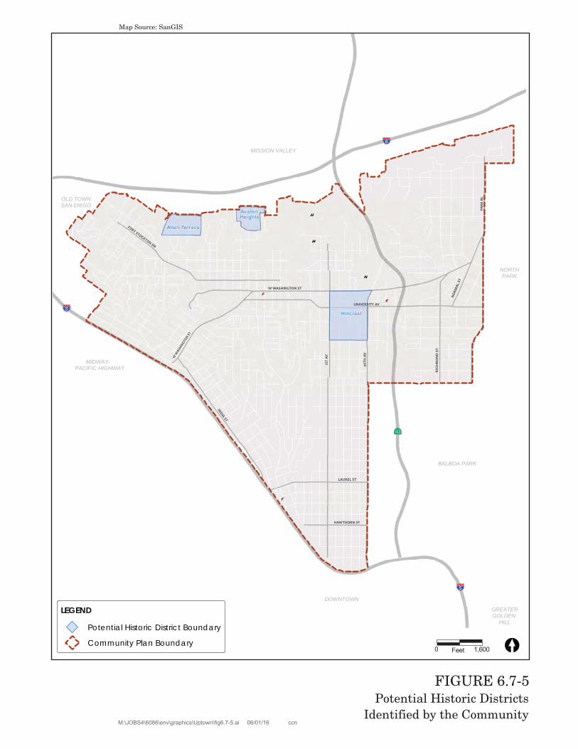
In addition to these individual resources, four additional Potential Historic Districts have been identified by the community (Figure 6.7-5). These include Allen Terrace, Avalon Heights, Hillcrest, and San Diego Normal School/San Diego City Schools Education Complex. The San Diego Normal School/San Diego City Schools Education Complex was the subject of a reconnaissance survey commissioned by the University Heights Historical Society and completed by a qualified historic consultant. Staff conducted a windshield survey to verify the presence of a potential historic district in the other three areas and concurred that these areas may be eligible for designation as Potential Historic Districts. However, the windshield survey undertaken in these areas was not as thorough as the Uptown Community Plan Area Historic Resources Survey (2014) and did not include identification of contributing and non-contributing resources. In regard to Hillcrest, it must be noted that the survey work completed in 2004 to 2006 did not initially identify a potential district in the Hillcrest area. However, the date and reconnaissance nature of the survey significantly limited the evaluation of resources associated with the final theme of revitalization and LGBTQ history. Given the fact that many business catering to and run by members of the LGBTQ community are concentrated within the Hillcrest area, along with residential units occupied by individuals and early advocacy groups, it is appropriate to identify Hillcrest as a potential historic district under Historical Resources Board Criterion A. In addition, because the Hillcrest Potential Historic District area includes 55 properties constructed from 1960 to 1975, and because the 2004 to 2006 survey did not consider any properties constructed post-1960 as potential resources, it is appropriate to consider that the district may also be eligible under Historical Resources Board Criterion C. In order to bring these four potential districts forward for designation, additional, intensive-level research would be required to evaluate the district and define a precise boundary, period of significance, significance criteria, and contributing and non-contributing resources.
W W
ASHIN
GTON S
T
BALBOA PARK
GREATERGOLDEN
HILL
NORTHPARK
OLD TOWNSAN DIEGO
DOWNTOWN
MISSION VALLEY
MIDWAY- PACIFIC HIGHWAY
!"_$
!"̂$
AgH
!"̂$
INDIA ST
PARK
BL
06TH
AV
W WASHINGTON ST
UNIVERSITY AV
RICH
MO
ND
ST
NORM
AL S
T
LAUREL ST
FORT STOCKTON DR
HAWTHORN ST
1ST
AV
LEGEND
Potential Historic District Boundary
Community Plan BoundaryCopyright 2012 SanGIS - All Rights Reserved. Full text of this legal
Uptown is home to 12 National Register-listed properties, 340 individually designated historic resources (see Figure 6.7-1), and two designated historic districts (see Figure 6.7-2) that are protected and preserved through existing General Plan policies, the historical resources regulations and guidelines of the Municipal Code, and established City practices. These protections require historic review of all projects impacting these resources. Projects that do not comply with the U.S. Secretary of the Interior Standards are required to process a discretionary action with deviations that are subject to review under California Environmental Quality Act (CEQA).
The Historical Resources Survey conducted for Uptown identified 2,192 properties as potentially significant individual resources, 59 of which are also located in Potential Historic Districts. The resources identified can be found in the Uptown Historic Survey Report. Of the resources identified as potentially significant individual resources, approximately 56 percent are single-family properties, 35 percent are multi-family properties, eight percent are commercial properties, and one percent institutional properties. In addition to potentially individually significant resources, the survey identified 19 potential Historic Districts as well as three potential MPLs.
Specifically, San Diego Municipal Code Section 143.0212 requires review of ministerial and discretionary permit applications impacting parcels containing buildings 45 years old or older to determine whether or not the project has the potential to adversely impact a resource that may be eligible for individual listing on the local register. When it is determined that a resource may exist and a proposed project would constitute a significant impact to that resource, a site-specific survey is required and may be forwarded to the Historical Resources Board to consider designation and listing of the property. If designated, a Site Development Permit with deviation findings and mitigation would be required for any substantial modification of the resource. If the property were not designated, modification of the property would not be subject to the Historical Resources Regulations. Potential individual resources and resources identified as part of the MPL, which are evaluated as single resources independent of other buildings, would be protected to a large extent through San Diego Municipal Code Section 143.0212. However, because this regulation limits the evaluation of historic resources to the project parcel and individual eligibility, resources identified as potentially contributing to a potential historic district would not be protect unless they were also eligible individually.
The proposed Uptown CPU and associated discretionary actions would have a significant direct impact on historical resources if they result in the demolition, relocation, or substantial alteration of a resource listed in, or formally determined eligible for listing in the National Register of Historic Places (NRHP) or the California Register of Historic Resources (CRHR), including contributors to NRHP and CRHR-eligible Historic Districts, or the San Diego Historical Resources Register, including contributors to San Diego Register Historic Districts, or which otherwise meet CEQA criteria for historic resources, as discussed above. Although the proposed Uptown CPU and associated discretionary actions do not propose specific development, future development and related construction activities facilitated by the proposed Uptown CPU and associated discretionary actions at the project level could result in the alteration of a historic building, structure, object, or site. Direct impacts may include substantial alteration, relocation, or demolition of historic buildings, structures, objects, sites, and districts. Indirect impacts may include the introduction of visual, audible, or
atmospheric effects that are out of character with a historic property or alter its setting, when the setting contributes to the resource’s significance.
Section 143.0212 of the San Diego Municipal Code requires review of ministerial and discretionary permit applications for any parcel identified as sensitive on the Historical Resource Sensitivity Maps specifically to determine whether or not the project has the potential to adversely impact an archaeological resource which may be eligible for individual listing on the local register. In these cases, this review is supplemented with a project-specific records search of the California Office of Historic Preservation’s California Historical Resources Information System (CHRIS) data by qualified staff and a site-specific survey would be required. In addition to these existing protections on historic resources, tThe Uptown CPU contains a Historic Preservation Element that supports the Historic Preservation Element of the General Plan through goals and policies for identifying and preserving historical, archaeological and tribal cultural resources, and educating citizens about the benefits of, and incentives for, historic preservation. Proposed policies supporting the identification and preservation of historical resources are included in the Urban Design and Conservation elements of the proposed Uptown CPU. Policies seek to preserve and enhance the historic character of the Uptown community and facilitate the identification, designation, and preservation of historically and culturally significant resources throughout the Uptown CPU area. In response to this policy, the proposed CPU identifies Potential Historic Districts. Supplemental development regulations to the Historical Resources Regulations would address how and where modifications can be made on residential properties identified as potentially contributing to specified Potential Historic Districts. Development that does not comply with the regulations of the supplemental development regulations would be subject to a Neighborhood Development Permit with deviation findings and mitigation.
While the Municipal Code does provide for the regulation and protection of designated and potential historical resources, and while supplemental development regulations would provide additional protection for Potential Historic Districts, it is impossible to ensure the successful preservation of all historic built environment resources within the plan area. Therefore, impacts to the Potential Historic Districts and individual historic resources would be considered significant and unavoidable.
Impact 6.7-1: Implementation of the proposed Uptown CPU and associated discretionary actions could result in an alteration of a historic building, structure, object, or site.
Issue 2 Prehistoric Resources, Sacred Sites and Human Remains
The Preshistoric Cultural Resources Study identified 14 recorded archaeological sites and 98 previous investigations conducted within the community of Uptown. Although there is very little undeveloped land within the CPU area, future development and related construction activities facilitated by the proposed Uptown CPU at the project level could result in the alteration or destruction of prehistoric resources, objects, or sites and could impact religious or sacred uses; or disturb human remains, particularly at the base of canyons leading into the Mission Valley area and in proximity to the Presidio and areas bordering Old Town. Direct impacts may include substantial alteration or demolition of archaeological sites from grading, excavation, or other ground-disturbing
activities. Indirect impacts may include the potential for vandalism or destruction of an archaeological resource or traditional cultural property.
Avoiding impacts on religious or sacred places or human remains may be unavoidable in certain circumstances when resources are discovered during construction. Although there are no known religious or sacred uses within the CPU area, there is potential for these to be encountered during future construction activities associated with implementation of the proposed Uptown CPU and associated discretionary actions, particularly given the high cultural sensitivity of canyon areas leading into the Mission Valley area, which has been previously identified as an area of concern to the local Native American community, and in proximity to the Presidio and areas bordering Old Town. Similarly, there are no known human remains interred outside of formal cemeteries. However, there are many areas within the City where previously unknown prehistoric human remains and prehistoric sites have been uncovered during both archaeological investigations and grading activities. Therefore, tribal consultation in accordance with AB 52 and the Public Resources Code has been incorporated into the Mitigation Framework for subsequent projects to ensure that tribal cultural resources are addressed early in the development review process. However, the potential for encountering human remains during construction activities remains a possibility.
The City has developed Historic Resource Sensitivity Maps that provide general locations of where Historical Resources are known to occur or have the potential to occur. These maps were developed in coordination with technical experts and tribal representatives. Upon submittal of ministerial and/or discretionary permit applications, a parcel is reviewed against the Historical Resource Sensitivity Maps specifically to determine whether or not the project has the potential to adversely impact an archaeological resource which may be eligible for individual listing on the local register (SDMC Section 143.0212).
Section 143.0212 of the SDMC requires review of ministerial and discretionary permit applications for any parcel identified as sensitive on the Historical Resource Sensitivity Maps specifically to determine whether or not the project has the potential to adversely impact an archaeological resource which may be eligible for individual listing on the local register. In these cases, tThis review is supplemented with a project specific records search of the NAHC Sacred Lands File by qualified staff, and as stated above, a site specific archaeological survey would be required. For any subsequent projects implemented in accordance with the CPU where a recorded archaeological site or Tribal Cultural Resource (as defined in the Public Resources Code) is identified, the City would be required to initiate consultation with identified California Indian tribes pursuant to the provisions in Public Resources Code Section 21080.3.1 and 21080.3.2., in accordance with Assembly Bill 52. Results of the consultation process will determine the nature and extent of any additional archaeological evaluation or changes to the proposed project and appropriate mitigation measures for direct impacts that cannot be avoided.
The proposed Uptown CPU is designed to support the historic preservation goals of the City’s General Plan, and contains policies requiring protection and preservation of significant archaeological resources in the proposed Historic Preservation Element. Native American consultation early in the project review process is also included in the proposed Uptown CPU to identify tribal cultural resources and to develop adequate treatment and mitigation for significant
archaeological sites with cultural and religious significance to the Native American community in accordance with all applicable local, state and federal regulations and guidelines.
While existing regulations, the Municipal Code, and proposed Uptown CPU policies would provide for the regulation and protection of archaeological resources and human remains, it is impossible to ensure the successful preservation of all archaeological resources. Therefore, potential impacts to archaeological resources are considered significant.
Impact 6.7-2: Implementation of the proposed Uptown CPU and associated discretionary actions could adversely impact a prehistoric archaeological resource including religious or sacred use sites and human remains.
6.7.5 Significance of Impacts
Implementation of the Uptown CPU could result in an alteration of a historic building, structure, object, or site (Impact 6.7-1) and could adversely impact a prehistoric archaeological and tribal cultural resources including religious or sacred use sites and human remains (Impact 6.7-2). These impacts would be potentially significant.
6.7.6 Mitigation Framework
The City of San Diego’s General Plan, combined with federal, state, and local regulations, provide a regulatory framework for project-level historical resources evaluation/analysis criteria and, when applicable, mitigation measures for future discretionary projects. All development projects with the potential to affect historical resources—such as designated historical resources; historical buildings, districts, landscapes, objects, and structures; important archaeological sites; tribal cultural resources, and traditional cultural properties—are subject to site-specific review in accordance with the City’s Historical Resources Regulations and Historical Resources Guidelines, through the subsequent project review process. The following mitigation measures (HIST-6.7-1 and HIST 6.7-2) provide a framework that would be required of all development projects with the potential to impact significant historical resources.
HIST 6.7-1: Historic Buildings, Structures, and Objects
Prior to issuance of any permit for a development project implemented in accordance with the proposed Uptown CPU and associated discretionary actions that would directly or indirectly affect a building/structure in excess of 45 years of age, the City shall determine whether the affected building/structure is historically significant. The evaluation of historic architectural resources shall be based on criteria such as: age, location, context, association with an important person or event, uniqueness, or structural integrity, as indicated in the Guidelines.
Preferred mitigation for historic buildings or structures shall be to avoid the resource through project redesign. If the resource cannot be entirely avoided, all prudent and feasible measures to minimize harm to the resource shall be taken. Depending upon project impacts, measures shall include, but are not limited to:
Adding new construction which is compatible in size, scale, materials, color and workmanship to the historical resource (such additions, whether portions of existing buildings or additions to historic districts, shall be clearly distinguishable from historic fabric);
Repairing damage according to the Secretary of the Interior's Standards for Rehabilitation;
Screening incompatible new construction from view through the use of berms, walls and landscaping in keeping with the historic period and character of the resource; and
Shielding historic properties from noise generators through the use of sound walls, double glazing and air conditioning.
Specific types of historical resource reports, outlined in Section III of the Historical Resources Guidelines, are required to document the methods to be used to determine the presence or absence of historical resources, to identify potential impacts from a proposed project, and to evaluate the significance of any historical resources identified. If potentially significant impacts to an identified historical resource are identified these reports will also recommend appropriate mitigation to reduce the impacts to below a level of significance, where possible. If required, mitigation programs can also be included in the report.
HIST-6.7-2: Archaeological and Tribal Cultural Resources
Prior to issuance of any permit for a future development project implemented in accordance with the proposed Uptown CPU and associated discretionary actions that could directly affect an archaeological or tribal cultural resource, the City shall require the following steps be taken to determine: (1) the presence of archaeological or tribal cultural resources and (2) the appropriate mitigation for any significant resources which may be impacted by a development activity. Sites may include, but are not limited to, residential and commercial properties, privies, trash pits, building foundations, and industrial features representing the contributions of people from diverse socio-economic and ethnic backgrounds. Sites may also include resources associated with prehistoric Native American activities.
Initial Determination
The environmental analyst will determine the likelihood for the project site to contain historical resources by reviewing site photographs and existing historic information (e.g. Archaeological Sensitivity Maps, the Archaeological Map Book, and the City’s “Historical Inventory of Important Architects, Structures, and People in San Diego”) and may conduct a site visit, as needed. If there is any evidence that the site contains archaeological or tribal cultural resources, then an archaeological
evaluation consistent with the City Guidelines would be required. All individuals conducting any phase of the archaeological evaluation program must meet professional qualifications in accordance with the City Guidelines.
Step 1:
Based on the results of the Initial Determination, if there is evidence that the site contains a historical resource, preparation of a historic evaluation is required. The evaluation report would generally include background research, field survey, archaeological testing and analysis. Before actual field reconnaissance would occur, background research is required which includes a record search at the SCIC at San Diego State University and the San Diego Museum of Man. A review of the Sacred Lands File maintained by the NAHC must also be conducted at this time. Information about existing archaeological collections should also be obtained from the San Diego Archaeologyical Center and any tribal repositories or museums.
In addition to the record searches mentioned above, background information may include, but is not limited to: examining primary sources of historical information (e.g., deeds and wills), secondary sources (e.g., local histories and genealogies), Sanborn Fire Maps, and historic cartographic and aerial photograph sources; reviewing previous archaeological research in similar areas, models that predict site distribution, and archaeological, architectural, and historical site inventory files; and conducting informant interviews. The results of the background information would be included in the evaluation report.
Once the background research is complete, a field reconnaissance must be conducted by individuals whose qualifications meet the standards outlined in the City Guidelines. Consultants are encouraged to employ innovative survey techniques when conducting enhanced reconnaissance, including, but not limited to, remote sensing, ground penetrating radar, and other soil resistivity techniques as determined on a case-by-case basis. Native American participation is required for field surveys when there is likelihood that the project site contains prehistoric archaeological resources or traditional cultural properties. If through background research and field surveys historical resources are identified, then an evaluation of significance, based on the City Guidelines, must be performed by a qualified archaeologist.
Step 2
Where a recorded archaeological site or Tribal Cultural Resource (as defined in the Public Resources Code) is identified, the City would be required to initiate consultation with identified California Indian tribes pursuant to the provisions in Public Resources Code Section 21080.3.1 and 21080.3.2., in accordance with Assembly Bill 52. It should be noted that during the consultation process tribal representative(s) will be directly involved in making recommendations regarding the significance of a tribal cultural resource which also could be a prehistoric archaeological site. A testing program may be recommended which requires
reevaluation of the proposed project in consultation with the Native American representative which could result in a combination of project redesign to avoid and/or preserve significant resources as well as mitigation in the form of data recovery and monitoring (as recommended by the qualified archaeologist and Native American representative). The archaeological testing program, if required will shall include evaluating the horizontal and vertical dimensions of a site, the chronological placement, site function, artifact/ecofact density and variability, presence/absence of subsurface features, and research potential. A thorough discussion of testing methodologies, including surface and subsurface investigations, can be found in the City Guidelines. Results of the consultation process will determine the nature and extent of any additional archaeological evaluation or changes to the proposed project.
The results from the testing program shall be evaluated against the Significance Thresholds found in the Guidelines. If significant historical resources are identified within the Area of Potential Effect, the site may be eligible for local designation. However, this process would not proceed until such time that the tribal consultation has been concluded and an agreement is reached (or not reached) regarding significance of the resource and appropriate mitigation measures are identified. When appropriate, the final testing report must be submitted to Historical Resources Board staff for eligibility determination and possible designation. An agreement on the appropriate form of mitigation is required prior to distribution of a draft environmental document. If no significant resources are found, and site conditions are such that there is no potential for further discoveries, then no further action is required. Resources found to be non-significant as a result of a survey and/or assessment will require no further work beyond documentation of the resources on the appropriate Department of Parks and Recreation site forms and inclusion of results in the survey and/or assessment report. If no significant resources are found, but results of the initial evaluation and testing phase indicates there is still a potential for resources to be present in portions of the property that could not be tested, then mitigation monitoring is required.
Step 3:
Preferred mitigation for historical resources is to avoid the resource through project redesign. If the resource cannot be entirely avoided, all prudent and feasible measures to minimize harm shall be taken. For archaeological resources where preservation is not an option, a Research Design and Data Recovery Program is required, which includes a Collections Management Plan for review and approval. When tribal cultural resources are present and also cannot be avoided, appropriate and feasible mitigation will be determined through the tribal consultation process and incorporated into the overall data recovery program, where applicable or project specific mitigation measures incorporated into the project. The data recovery program shall be based on a written research design and is subject to the provisions as outlined in CEQA, Section 21083.2. The data recovery program must be reviewed and approved by the City’s Environmental Analyst prior to distribution of a draft
CEQA document and shall include the results of the tribal consultation process. Archaeological monitoring may be required during building demolition and/or construction grading when significant resources are known or suspected to be present on a site, but cannot be recovered prior to grading due to obstructions such as, but not limited to, existing development or dense vegetation.
A Native American observer must be retained for all subsurface investigations, including geotechnical testing and other ground-disturbing activities, whenever a Native American Traditional Cultural Propertytribal cultural resource or any archaeological site located on City property or within the Area of Potential Effect of a City project would be impacted. In the event that human remains are encountered during data recovery and/or a monitoring program, the provisions of Public Resources Code Section 5097 must be followed. In the event that human remains are discovered during project grading, work shall halt in that area and the procedures set forth in the California Public Resources Code (Section 50987.98) and State Health and Safety Code (Section 7050.5), and in the federal, state, and local regulations described above shall be undertaken. These provisions will be outlined in the Mitigation Monitoring and Reporting Program (MMRP) included in a subsequent project-specific environmental document. The Native American monitor shall be consulted during the preparation of the written report, at which time they may express concerns about the treatment of sensitive resources. If the Native American community requests participation of an observer for subsurface investigations on private property, the request shall be honored.
Step 4:
Archaeological Resource Management reports shall be prepared by qualified professionals as determined by the criteria set forth in Appendix B of the Guidelines. The discipline shall be tailored to the resource under evaluation. In cases involving complex resources, such as traditional cultural properties, rural landscape districts, sites involving a combination of prehistoric and historic archaeology, or historic districts, a team of experts will be necessary for a complete evaluation.
Specific types of historical resource reports are required to document the methods (see Section III of the Guidelines) used to determine the presence or absence of historical resources; to identify the potential impacts from proposed development and evaluate the significance of any identified historical resources; to document the appropriate curation of archaeological collections (e.g. collected materials and the associated records); in the case of potentially significant impacts to historical resources, to recommend appropriate mitigation measures that would reduce the impacts to below a level of significance; and to document the results of mitigation and monitoring programs, if required.
Archaeological Resource Management reports shall be prepared in conformance with the California Office of Historic Preservation "Archaeological Resource Management Reports: Recommended Contents and Format" (see Appendix C of the Guidelines), which will be used by Environmental staff in the review of archaeological
resource reports. Consultants must ensure that archaeological resource reports are prepared consistent with this checklist. This requirement will standardize the content and format of all archaeological technical reports submitted to the City. A confidential appendix must be submitted (under separate cover) along with historical resources reports for archaeological sites and tribal cultural resources containing the confidential resource maps and records search information gathered during the background study. In addition, a Collections Management Plan shall be prepared for projects which result in a substantial collection of artifacts and must address the management and research goals of the project and the types of materials to be collected and curated based on a sampling strategy that is acceptable to the City. Appendix D (Historical Resources Report Form) may be used when no archaeological resources were identified within the project boundaries.
Step 5:
For Archaeological Resources: All cultural materials, including original maps, field notes, non-burial related artifacts, catalog information, and final reports recovered during public and/or private development projects must be permanently curated with an appropriate institution, one which has the proper facilities and staffing for insuring research access to the collections consistent with state and federal standards, unless otherwise determined during the tribal consultation process. In the event that a prehistoric and/or historic deposit is encountered during construction monitoring, a Collections Management Plan would be required in accordance with the project MMRP. The disposition of human remains and burial related artifacts that cannot be avoided or are inadvertently discovered is governed by state (i.e., Assembly Bill 2641 [Coto] and California Native American Graves Protection and Repatriation Act of 2001 [Health and Safety Code 8010-8011]) and federal (i.e., Native American Graves Protection and Repatriation Act [U.S.C. 3001-3013]) law, and must be treated in a dignified and culturally appropriate manner with respect for the deceased individual(s) and their descendants. Any human bones and associated grave goods of Native American origin shall be turned over to the appropriate Native American group for repatriation.
Arrangements for long-term curation of all recovered artifacts must be established between the applicant/property owner and the consultant prior to the initiation of the field reconnaissance. When tribal cultural resources are present, or non-burial-related artifacts associated with tribal cultural resources area suspected to be recovered, the treatment and disposition of such resources will be determined during the tribal consultation process. This information must then be included in the archaeological survey, testing, and/or data recovery report submitted to the City for review and approval. Curation must be accomplished in accordance with the California State Historic Resources Commission’s Guidelines for the Curation of Archaeological Collection (dated May 7, 1993) and, if federal funding is involved, Title 36 of the Code of Federal Regulations, Part 79 of the Federal Register. Additional information regarding curation is provided in Section II of the Guidelines.
Development implemented in accordance with the proposed Uptown CPU and associated discretionary actions that would potentially result in impacts to significant historical resources would be required to incorporate feasible mitigation measures adopted in conjunction with the certification of this PEIR and consistent with existing requirements of the Historic Resources Regulations and Historic Resources Guidelines. The mitigation framework combined with the proposed Uptown CPU policies promoting the identification and preservation of historical resources would reduce the program-level impact related to historical resources of the built environment. However, even with implementation of the mitigation framework, the degree of future impacts and applicability, feasibility, and success of future mitigation measures cannot be adequately known for each specific future project at this program level of analysis.
With respect to Potential Historic Districts, while supplemental development regulations would provide some protections, until such time as the Potential Historic Districts are intensively surveyed, verified, and brought forward for designation consistent with City regulations and procedures, potential impacts to the Potential Historic Districts would remain significant and unavoidable. Thus, potential impacts to historical resources including historic structures, objects or sites and historic districts would be significant and unavoidable.
6.7.7.2 Prehistoric Resources, Sacred Sites, and Human Remains
Development implemented in accordance with the proposed Uptown CPU and associated discretionary actions would potentially result in impacts to significant archaeological and tribal cultural resources, and therefore would be required to implement mitigation measure HIST-6.7-2, which addresses measures to minimize impacts to archaeological and tribal cultural resources. This mitigation, combined with the policies of the General Plan and proposed Uptown CPU policies promoting the identification, protection, and preservation of archaeological resources, in addition to compliance with CEQA and Public Resources Code Section 21080.3.1 requiring tribal consultation early in the development review process, and the City’s Historic Resources Regulations (San Diego Municipal Code Section 143.0212), which requires review of ministerial and discretionary permit applications for any parcel identified as sensitive on the Historical Resources Sensitivity Maps would reduce the program-level impact related to prehistoric or historical archaeological resources and tribal cultural resources. However, even with application of the existing regulatory framework and mitigation framework, the feasibility and efficacy of mitigation measures cannot be determined at this program level of analysis. Thus, impacts to prehistoric resources, sacred sites, and human remains would be minimized but not to below a level of significance.