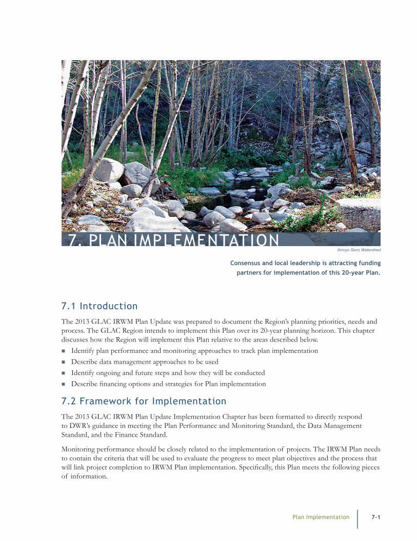
Plan Implementation 7-1 7. PLAN IMPLEMENTATION 7.1 Introduction The 2013 GLAC IRWM Plan Update was prepared to document the Region’s planning priorities, needs and process. The GLAC Region intends to implement this Plan over its 20-year planning horizon. This chapter discusses how the Region will implement this Plan relative to the areas described below. Identify plan performance and monitoring approaches to track plan implementation Describe data management approaches to be used Identify ongoing and future steps and how they will be conducted Describe financing options and strategies for Plan implementation 7.2 Framework for Implementation The 2013 GLAC IRWM Plan Update Implementation Chapter has been formatted to directly respond to DWR’s guidance in meeting the Plan Performance and Monitoring Standard, the Data Management Standard, and the Finance Standard. Monitoring performance should be closely related to the implementation of projects. The IRWM Plan needs to contain the criteria that will be used to evaluate the progress to meet plan objectives and the process that will link project completion to IRWM Plan implementation. Specifically, this Plan meets the following pieces of information. Consensus and local leadership is attracting funding partners for implementation of this 20-year Plan. Arroyo Seco Watershed
Transcript
Plan Implementation 7-1
7. PLAN IMPLEMENTATION
7.1 Introduction
The 2013 GLAC IRWM Plan Update was prepared to document the Region’s planning priorities, needs and process. The GLAC Region intends to implement this Plan over its 20-year planning horizon. This chapter discusses how the Region will implement this Plan relative to the areas described below.
� Identify plan performance and monitoring approaches to track plan implementation � Describe data management approaches to be used � Identify ongoing and future steps and how they will be conducted � Describe financing options and strategies for Plan implementation
7.2 Framework for Implementation
The 2013 GLAC IRWM Plan Update Implementation Chapter has been formatted to directly respond to DWR’s guidance in meeting the Plan Performance and Monitoring Standard, the Data Management Standard, and the Finance Standard.
Monitoring performance should be closely related to the implementation of projects. The IRWM Plan needs to contain the criteria that will be used to evaluate the progress to meet plan objectives and the process that will link project completion to IRWM Plan implementation. Specifically, this Plan meets the following pieces of information.
Consensus and local leadership is attracting funding partners for implementation of this 20-year Plan.
Arroyo Seco Watershed
7-2 Plan Implementation
Greater Los Angeles County Integrated Regional Water Management Plan
� Contain an explanation of whom or what group within the LC will be responsible for IRWM implementation evaluation
� List the frequency of evaluating the LC’s performance at implementing projects in the IRWM Plan
� Explain how IRWM implementation will be tracked with a Data Management System (DMS) and who will be responsible for maintaining the DMS
� Discuss how findings or “lessons learned” from project-specific monitoring efforts will be used to improve the LC’s ability to implement future projects in the IRWM Plan
� Identify who has the primary responsibility for development of the project-specific monitoring plans and who is responsible for project-specific monitoring activities
� Specify the stage of project development at which a project-specific monitoring plan will be prepared
� Provide an explanation of typically required contents of a project-specific monitoring plan
Data Management Standard
The intent of the Data Management Standard is to ensure efficient use of available data, stakeholder access to data, and to ensure the data generated by IRWM implementation activities can be integrated into existing State databases.
As specified in the Integration Standard, IRWM Plans should contain common protocols that gather data in a consistent manner and processes for data and information sharing that assists all IRWM stakeholders in their local and regional efforts. Data integration is best achieved through the use of common and compatible methods for data gathering, analysis, monitoring, and reporting systems used by members of the LC. The data management description in the IRWM Plan should be of sufficient detail so that it is clear to stakeholders how data are collected, validated, and shared in the region. At a minimum, the data management description in the IRWM Plan includes the following components.
� A brief overview of the data needs within the IRWM region
� A description of typical data collection techniques � A description of how stakeholders contribute
data to a DMS � The entity responsible for maintaining data in
the DMS � A description of the validation or quality
assurance/quality control measures that will be implemented by the LC for data generated and submitted for inclusion into the DMS
� An explanation of how data collected for IRWM project implementation will be trans-ferred or shared between members of the LC and other interested parties throughout the IRWM region, including local, State, and federal agencies
� An explanation of how the DMS supports the LC’s efforts to share collected data
� An outline of how the data saved in the DMS will be distributed and remain compatible with State databases including California Environmental Data Exchange Network (CEDEN), Water Data Library (WDL), California Statewide Groundwater Elevation Monitoring (CASGEM), California Environmental Information Catalog (CEIC), and the California Environmental Resources Evaluation System (CERES)
Finance Standard
The intent of the Finance Standard is to ensure that financing of the IRWM Plan has been consid-ered at a programmatic level by the LC; and that a snapshot of financing is documented for stake-holders. Most of the cost of developing, main-taining, and implementing an IRWM Plan is borne by local entities with State grant funding providing a necessary, but relatively small, supplement in funds. With potentially multiple sources of funding being accessed to formulate, maintain, and imple-ment an IRWM Plan, documentation of how the funding pieces fit together is necessary for the LC and its stakeholders to understand how the plan will be implemented. The IRWM Plan contains the following items.
Plan Implementation
Integrated Regional Water Management Plan Greater Los Angeles County
7-3
� A program-level description of the sources of funding, which will be utilized for the develop-ment and ongoing funding of the IRWM Plan
� The potential funding sources for projects and programs that implement the IRWM Plan
In addition to demonstrating potential funding for project construction, the IRWM Plan also contains a discussion of the potential sources of funding for project Operations and Maintenance (O&M).
7.3 Plan Performance and Monitoring
The GLAC Region will review and determine Plan performance in two ways.
� Ongoing Program: The Region will continue monthly LC and SC meetings and other gover-nance and stakeholder outreach processes as described in Chapter 1 as well as the regular project review process described in Chapter 5 of this Plan.
� Plan Update Process: As part of each subse-quent Plan Update (or more frequently if desired or necessary), the Region will review all projects funded through the IRWM implemen-tation program to date and relate the results and outcomes of these projects to the benefits achieved relative to the stated objectives and plan-ning targets described in Chapter 3 of this Plan.
Ongoing Program Operations and Maintenance
A key part of the GLAC Region’s Plan is the governance, stakeholder/DAC outreach and project development and review processes described in the previous chapters of this Update.
The implementation of the Plan relies upon the ongoing LC and SC meetings, project implementa-tion and the continuation of the DAC outreach efforts. The performance will be evaluated through regular meeting notes posted on the GLAC Region website and the project updates regularly being included in the project database.
Periodic Plan Update Process
GLAC IRWM projects that are implemented through the DWR funding program, require that project performance monitoring be developed and results reported as part of project implementation. The project’s proponents are responsible for data that is collected and provided to the Region and DWR as part of the regular reporting process. The project monitoring plans developed by the project proponents during the grant process must include the following information.
� Parameter or constituent being monitored � Measures to remedy or react to problems
encountered during monitoring � Location of monitoring � Monitoring frequency � Monitoring protocols and methodologies and
responsible parties � Data management process for tracking what is
monitored � Procedures to ensure monitoring schedule and
processes can be maintained
This data can also be used by the Region’s LC and SCs to determine the benefits achieved from a project. The required project reports will be posted on the GLAC IRWMP website that updates the Region on project progress and performance. The LC and SCs will be able to correlate a project’s benefit data to the Plan objectives and planning targets and be able to show progress made on these targets through project implementation.
As part of the regular SC meetings, project propo-nents will be invited to provide updates as well as lessons learnedfrom project implementation that can then be used to enhance the development of future IRWM projects for that Subregion and the Region as a whole. These lessons learned can be memorialized in meeting notes and posted on the Region’s website and project database for use in subsequent project selections, review of Regional Management Strategies and subsequent Plan Updates.
7-4 Plan Implementation
Greater Los Angeles County Integrated Regional Water Management Plan
The Region acknowledges that the majority of projects included as part of the IRWM Plan will need to be implemented fully through other funding sources because DWR IRWMP Implementation funding is limited. These proj-ects certainly help the Region meet its objectives and planning targets. However, it will take addi-tional resources to collect and integrate the data supporting the benefits achieved into the Plan Performance process and tie those benefits to the Plan objectives and targets.
7.4 Data Management
GLAC Data Management Approach
Since the GLAC Region has more municipalities and public agencies per square mile than anywhere in California, and each municipality and agency is responsible for monitoring a wide range of parameters for many varied programs, imple-menting a Region-wide comprehensive data collec-tion process into a single DMS, let alone one that is compatible with DWR requirements, would be prohibitively expensive at the current time without a commensurate benefit to stakeholders. Projects funded through the IRWM implementa-tion funding programs are required to provide data from approved project performance monitoring programs in formats already consistent with the list of state agency databases called out in DWR guid-ance. The GLAC Region has, therefore, determined that the project proponents will provide the data required consistent with their agreement with DWR
and as a condition of receiving funding for their project to track progress of the goals and objectives within this Plan. Therefore, the data provided by project proponents can be effectively shared and used by the State and the Region’s stakeholders.
It is, however, recognized that a great deal of valu-able data is collected from studies and projects not funded through the IRWM Program but which could benefit the Region and the State if made accessible. Therefore, if regional stakeholders and agencies wish to provide a link to their datasets on the GLAC Region’s website, these datasets could be accessed by stakeholders, but the Region would not be responsible for determining if these datasets meet DWR requirements nor for including the data into the Plan Performance assessment process.
Current Monitoring Efforts
It is important to note that there are ongoing monitoring programs that are collecting data in the Region not being directly reported to DWR through IRWM Project performance monitoring. Current pertinent monitoring activities in the Region are described briefly below.
Drinking Water Quality
� SDWA compliance monitoring and reporting: All public water systems are required to produce water that complies with the SDWA. To this end, specific monitoring is required and conducted routinely. Results of the monitoring are reported to the CDPH. In addition, moni-
SC AdministratorReviews
SC AdministratorSummarizes
Benefits Tracking
ProponentUploads
Performance Report
Project DatabaseProject Listing
DMSProject Monitoring
Figure 7-1: Plan Performance Process
Plan Implementation
Integrated Regional Water Management Plan Greater Los Angeles County
7-5
toring information is required to be published in the annual Consumer Confidence Report (also required by the SDWA).
� Unregulated Contaminant Monitoring Rule Results: The 1996 SDWA Amendments mandate that USEPA publish a list of unregu-lated contaminants that may pose a potential public health risk in drinking water. This list is called the Contaminant Candidate List (CCL). The initial 1998 accounting listed 60 contami-nants. USEPA uses this list to prioritize research and data collection efforts for future rulemaking purposes. The 1996 SDWA amendments incor-porated a tiered monitoring approach. The rule required all large public water systems and a nationally representative sample of small public water systems serving fewer than 10,000 people to monitor the contaminants.
� Groundwater Contamination: MWD produces periodic summaries of groundwater contamination in Southern California.
� Water Supply: Sources of data for water supply quantities include individual agency UWMPs that are updated every 5 years, MWD’s IRP updates, and MWD’s IRP Report Card. These include the amount of single dry-year and multiple dry-year supplies developed to date, projected single dry-year and multiple dry-year demands over a 20-year planning horizon and the gap between the existing supplies and demands.
Surface Water Quality
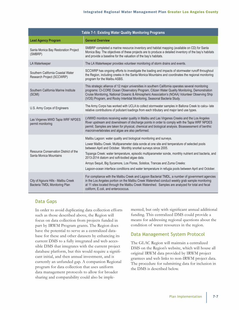
Numerous agencies and organizations have been conducting monitoring of surface water quality in the Region for years. Table 7-1 identifies a few of these programs that supply data to support the implemen-tation of statewide programs such as TMDL devel-opment and implementation of the Clean Water Act 303(d) Listing of impaired water bodies.
Table 7-1: Existing Water Quality Monitoring Programs
Lead Agency Program General Overview
City of Los Angeles lead Ballona Creek Metals and Bacteria TMDLS
The City of Los Angeles coordinates monitoring efforts required by TMDLs in Ballona Creek Watershed, including the Ballona Creek Metals, the Ballona Creek Estuary Toxic Pollutants, and the Ballona Creek Bacteria TMDLs. The County and other stakeholders in the watershed contribute to the effort.
Caltrans Caltrans conducts monitoring aimed at estimating loadings from highway runoff.
City of Los Angeles Cleaner Rivers through Effective Stakeholder-led TMDLs (CREST)
CREST is a stakeholder effort initiated by the City of Los Angeles to develop TMDLs to restore and protect water quality in the Los Angeles River and Ballona Creek. TMDL strategies must include monitoring as the final step.
City of Long Beach Colorado Lagoon OC Pesticides, PCBs, Sediment Toxicity, PAHs, and Metals TMDL
The City of Long Beach leads monitoring efforts for Toxics TMDL in Colorado Lagoon. The County and Caltrans contribute to the effort.
Dominguez Channel and Greater Los Angeles and Long Beach Harbor Waters Toxic Pollutants TMDL
The City of Los Angeles coordinates monitoring efforts for TMDLs in the Dominguez Channel and the Greater Los Angeles and Long Beach Harbor. The County and other stakeholders in the watershed contribute to the effort.
Friends of the Los Angeles River (FoLAR) RiverWatch (319(h) grant program)
A 319(h) grant program monitoring the quality of water at 60 sites along the full length of the Los Angeles River on a monthly basis, surveying the river’s biota in natural bottomed areas and tracking seasonal changes in the river and related habitat. FoLAR publishes a State of the River Report and intends to develop a successful and long-term volunteer river monitoring program.
Heal the Bay Beach Monitoring Heal the Bay reports the monitoring results of total coliform, fecal coliform, enteroccus, and total fecal ratio done by various environmental health laboratories.
Los Angeles Basin Water Augmentation Study
The Council for Watershed Health is monitoring six sites to deter- mine whether infiltration of storm-water results in the subsequent migration of pollutants to groundwater. The Phase II Final Report is available at www.lasgrwc.org
7-6 Plan Implementation
Greater Los Angeles County Integrated Regional Water Management Plan
Table 7-1: Existing Water Quality Monitoring Programs
Lead Agency Program General Overview
Los Angeles Basin Contaminated Sediment Task Force
The task force is conducting a study to identify sources of heavy metals loadings within the Ballona Creek Watershed. Study results could support the development of a TMDL for selected heavy metals.
City of Los Angeles Los Angeles River Metals TMDL Monitoring Plan
The City of Los Angeles leads monitoring efforts required under Metals and Bacteria TMDLs in the Los Angeles River watershed. The County and other stakeholders in the watershed contribute to the effort.
Los Angeles County Department of Public Works
LACDPW monitors runoff from major watersheds, including some tributaries, during multiple storm events as well as during dry weather in order to comply with its NPDES permit. Samples are taken for physical, chemical and biological analysis; toxicity testing, bioassessment and trash monitoring are also performed. Details of the NPDES monitoring program and prior year’s data are found in the annual monitoring reports at http://ladpw.org/wmd/NPDES/report_directory.cfm.
Los Angeles County Department of Public Health, and City of Los Angeles Santa Monica Bay Beaches Bacteria TMDL Monitoring
The TMDL, which has been divided into dry weather and wet weather, each having its own compliance dates and limits, encompasses 27 subwatersheds that cover 44 303(d)-listed beaches from Malibu to Palos Verdes. The Coordinated Shoreline Monitoring Plan (CSMP) provided 67 sampling sites to be monitored on a weekly basis starting in November 2004.
Los Angeles County Department of Public Works, Machado Lake Nutrients & Toxics Monitoring Plan (Nutrients)
The County is conducting nutrients monitoring of its island areas in the watershed. Both dry and storm water monitoring is being conducted at up to 7 sites. Some sites include collection of observational data only.
LACFCD Machado Lake Nutrients & Toxics Monitoring Plan (Toxics)
LACFCD recently obtained approval of its Monitoring Plan from the Los Angeles Water Quality Control Board, Los Angeles Region.
LACFCD Marina del Rey Harbor Toxics TMDL Monitoring Plan
LACFCD will be starting the fourth year of monitoring that includes dry and wet weather sampling. Dry weather sampling is being conducted at 9 sites in the harbor. 5 sites in the watershed are being sampled during wet weather. All monitoring is being done in accordance with Regional Water Quality Control Board approved Coordinated Monitoring Plan. The plan also includes a Pilot Study to deter-mine the best method for storm borne sediment collection.
City of Los Angeles Marina del Rey Bacteria Monitoring Plan
The County and City of Los Angeles coordinates monitoring efforts for bacteria TMDL in Marina del Rey Harbor.
Port of Los Angeles Consolidated Slip Restoration Project Draft Plan
A Consolidated Slip Restoration Project draft plan by the Port of Los Angeles described the extent of sediment contamination in Consolidated Slip and the site’s history, identified data gaps, called for additional sediment sampling to characterize the area extent and vertical depth of Consolidated Slip contamination.
RWQCB SWAMP
The RWQCB has conducted SWAMP-funded monitoring of the North Santa Monica Bay and South Bay watersheds in fiscal years 2008-9 to 2012-13 in collaboration with the Southern California Stormwater Monitoring Coalition, and plans to continue funding monitoring in these watersheds for the next 5 years
Los Angeles River and San Gabriel River Regional Monitoring Program Work Group (including many county, regional, and local agencies, municipali-ties, and advisory organizations)
The Work Groups have developed regional monitoring programs for the Los Angeles and San Gabriel River water sheds and are now working on implementation. The monitoring programs integrate with existing monitoring efforts. The monitoring approach includes use of random sites in order to assess overall watershed health as well as directed sites at high habitat value areas and at the base of sub-watersheds. Probabilistic and targeted sampling are done for water quality, toxicity, and bioassess-ment and habitat condition. Extensive monitoring data are available as part of NPDES monitoring and reporting programs. and through the Council for Watershed Health at http://www.watershedhealth.org/programsandprojects/larwmp.aspx#
Santa Monica Bay Restoration Commission (SMBRC)
The SMBRC is developing new sources and loading monitoring design for point and NPS ocean discharges from the Santa Monica Bay Watershed.
Plan Implementation
Integrated Regional Water Management Plan Greater Los Angeles County
7-7
mented, but only with significant annual additional funding. This centralized DMS could provide a means for addressing regional questions about the condition of water resources in the region.
Data Management System Protocol
The GLAC Region will maintain a centralized DMS on the Region’s website, which will house all original IRWM data provided by IRWM project grantees and web links to non-IRWM project data. The procedure for submitting data for inclusion in the DMS is described below.
Table 7-1: Existing Water Quality Monitoring Programs
Lead Agency Program General Overview
Santa Monica Bay Restoration Project (SMBRP)
SMBRP completed a marine resource inventory and habitat mapping (available on CD) for Santa Monica Bay. The objectives of these projects are to produce a detailed inventory of the bay’s habitats and provide a baseline for the valuation of the bay’s habitats.
LA Waterkeeper The LA Waterkeeper provides volunteer monitoring of storm drains and events.
Southern California Coastal Water Research Project (SCCWRP)
SCCWRP has ongoing efforts to investigate the loading and impacts of stormwater runoff throughout the Region, including creeks in the Santa Monica Mountains and coordinates the regional monitoring program for the Malibu ASBS.
Southern California Marine Institute (SCMI)
This strategic alliance of 12 major universities in southern California operates several monitoring programs: CI-CORE Ocean Observatory Program, Citizen Water Quality Monitoring, Demonstration Cruise Monitoring, National Oceanic & Atmospheric Association’s (NOAA) Volunteer Observing Ship (VOS) Program, and Rocky Intertidal Monitoring, Seasonal Bacteria Study.
U.S. Army Corps of Engineers The Army Corps has worked with UCLA to collect stormwater samples in Ballona Creek to calcu- late relative contributions of pollutant loadings from each tributary and major land use types.
Las Virgenes MWD Tapia WRF NPDES permit monitoring
LVMWD monitors receiving water quality in Malibu and Las Virgenes Creeks and the Los Angeles River upstream and downstream of discharge points in order to comply with the Tapia WRF NPDES permit. Samples are taken for physical, chemical and biological analysis. Bioassessment of benthic macroinvertebrates and algae are also performed.
Resource Conservation District of the Santa Monica Mountains
Malibu Lagoon: water quality and biological monitoring and surveys. Lower Malibu Creek: Multiparameter data sonde at one site and temperature of selected pools between April and October. Monthly snorkel surveys since 2005.Topanga Creek: water temperature, episodic multiparameter sonde, monthly nutrient and bacteria, and 2013-2014 diatom and soft-bodied algae data.Arroyo Sequit, Big Sycamore, Los Flores, Solstice, Trancas and Zuma Creeks:Lagoon-ocean interface conditions and water temperature in refugia pools between April and October.
City of Agoura Hills - Malibu Creek Bacteria TMDL Monitoring Plan
For compliance with the Malibu Creek and Lagoon Bacterial TMDL, a number of government agencies in the Los Angeles portion on the Malibu Creek Watershed conduct weekly grab sample monitoring at 11 sites located through the Malibu Creek Watershed. Samples are analyzed for total and fecal coliform, E.coli, and enterococcus.
Data Gaps
In order to avoid duplicating data collection efforts such as those described above, the Region will focus on data collection from projects funded in part by IRWM Program grants. The Region does have the potential to serve as a centralized data-base for these and other datasets by enhancing its current DMS to a fully integrated and web acces-sible DMS that integrates with the current project database platform, but this would require a signifi-cant initial, and then annual investment, and is currently an unfunded gap. A companion Regional program for data collection that uses uniform data management protocols to allow for broader sharing and comparability could also be imple-
7-8 Plan Implementation
Greater Los Angeles County Integrated Regional Water Management Plan
1. The IRWM project grantee completes monitoring and data collection in accordance with DWR’s approved project-specific monitoring plan, including quality assurance/quality control (QA/QC) procedures.
2. The IRWM project grantee validates data consis-tent with data validation protocols outlined in the project-specific monitoring plan.
3. The IRWM project grantee “spot-checks” data for accuracy at the time of entry to the project database to identify any apparent errors.
4. The IRWM project grantee submits the data to the GLAC Region.
5. The GLAC Region maintains the data in the centralized database.
6. The GLAC Region disseminates the data to stakeholders and members of the public through the IRWM Plan webpage.
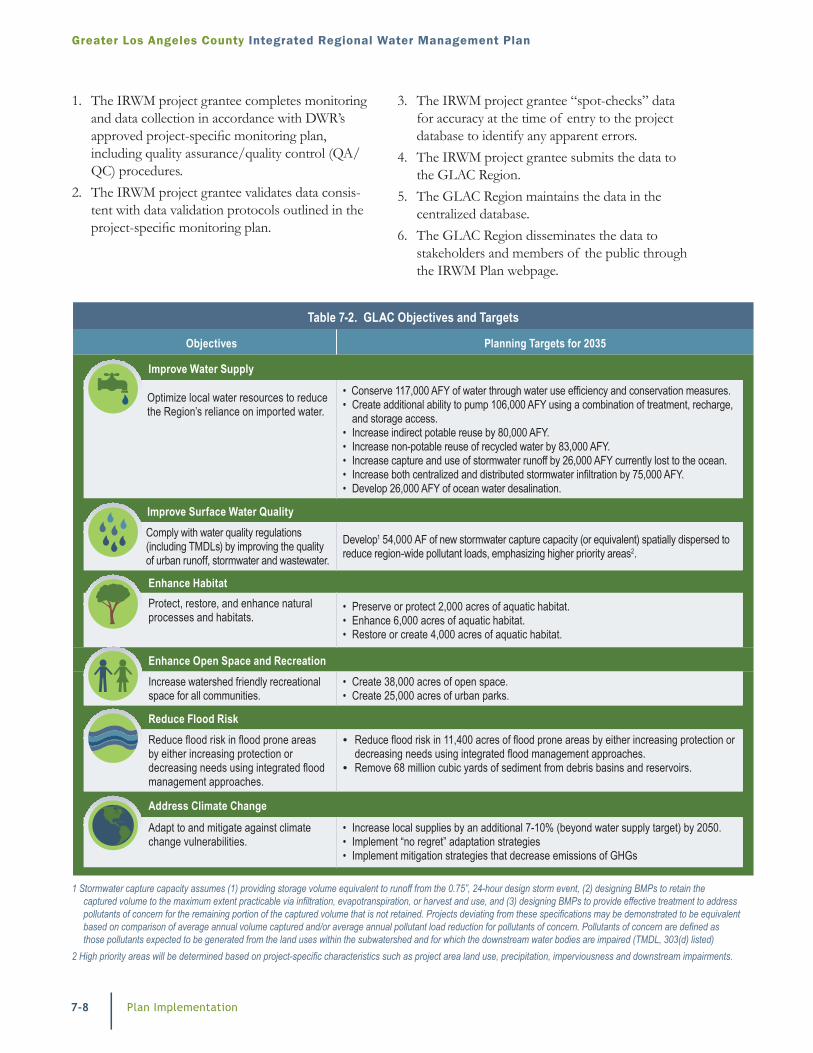
Table 7-2. GLAC Objectives and Targets
Objectives Planning Targets for 2035
Improve Water Supply
Optimize local water resources to reduce the Region’s reliance on imported water.
• Conserve 117,000 AFY of water through water use efficiency and conservation measures.• Create additional ability to pump 106,000 AFY using a combination of treatment, recharge,
and storage access.• Increase indirect potable reuse by 80,000 AFY.• Increase non-potable reuse of recycled water by 83,000 AFY.• Increase capture and use of stormwater runoff by 26,000 AFY currently lost to the ocean.• Increase both centralized and distributed stormwater infiltration by 75,000 AFY.• Develop 26,000 AFY of ocean water desalination.
Improve Surface Water QualityComply with water quality regulations (including TMDLs) by improving the quality of urban runoff, stormwater and wastewater.
Develop1 54,000 AF of new stormwater capture capacity (or equivalent) spatially dispersed to reduce region-wide pollutant loads, emphasizing higher priority areas2.
Enhance HabitatProtect, restore, and enhance natural processes and habitats.
• Preserve or protect 2,000 acres of aquatic habitat.• Enhance 6,000 acres of aquatic habitat.• Restore or create 4,000 acres of aquatic habitat.
Enhance Open Space and RecreationIncrease watershed friendly recreational space for all communities.
• Create 38,000 acres of open space.• Create 25,000 acres of urban parks.
Reduce Flood RiskReduce flood risk in flood prone areas by either increasing protection or decreasing needs using integrated flood management approaches.
• Reduce flood risk in 11,400 acres of flood prone areas by either increasing protection or decreasing needs using integrated flood management approaches.
• Remove 68 million cubic yards of sediment from debris basins and reservoirs.
Address Climate Change
Adapt to and mitigate against climate change vulnerabilities.
• Increase local supplies by an additional 7-10% (beyond water supply target) by 2050.• Implement “no regret” adaptation strategies• Implement mitigation strategies that decrease emissions of GHGs
1 Stormwater capture capacity assumes (1) providing storage volume equivalent to runoff from the 0.75”, 24-hour design storm event, (2) designing BMPs to retain the captured volume to the maximum extent practicable via infiltration, evapotranspiration, or harvest and use, and (3) designing BMPs to provide effective treatment to address pollutants of concern for the remaining portion of the captured volume that is not retained. Projects deviating from these specifications may be demonstrated to be equivalent based on comparison of average annual volume captured and/or average annual pollutant load reduction for pollutants of concern. Pollutants of concern are defined as those pollutants expected to be generated from the land uses within the subwatershed and for which the downstream water bodies are impaired (TMDL, 303(d) listed)
2 High priority areas will be determined based on project-specific characteristics such as project area land use, precipitation, imperviousness and downstream impairments.
Plan Implementation
Integrated Regional Water Management Plan Greater Los Angeles County
7-9
Data collected will be compatible with statewide databases because the project-specific monitoring plans will be developed based on guidance provided for applicable statewide database. While project sponsors will be responsible for submitting data to the appropriate statewide databases, LACFCD will be able to confirm that this has been done based on the confirmation of submittal required.
The DMS will serve the important function of assisting the LC in its goal to share collected data by requiring consistent methodologies for data collection and housing all data in a centralized location that is easily accessed by stakeholders and members of the public. In this way, the DMS assists the LC in accomplishing the objectives of improved data comparability and accessibility.
Compatibility with Statewide Databases
The IRWM project grantee submits the data that is compatible with statewide databases, as applicable.
Data collected will be compatible with statewide databases because the project-specific monitoring plans will be developed based on guidance provided for applicable statewide database. While project sponsors will be responsible for submitting data to the appropriate statewide databases, LACFCD will be able to confirm that this has been done based on the confirmation of submittal required.
The DMS will serve the important function of assisting the LC in its goal to share collected data by requiring consistent methodologies for data collection and housing all data in a centralized location that is easily accessed by stakeholders and members of the public. In this way, the DMS assists the LC in accomplishing the objectives of improved data comparability and accessibility
Data Collection Techniques
Data collected in conjunction with Plan implementa-tion projects will vary based on the type and scope of each individual project. Table 7-3 below outlines the types of data expected to be collected by project type. These data will include, at a minimum, data relevant to surface water, groundwater, water quality, stormwater, and ecosystem restoration.
Table 7-3. Potential Data to be Collected through IRWM Project Implementation
Data Type
Project Type
Wat
er S
uppl
y
Recy
cled
Wat
er
Wat
er Q
ualit
y
Stor
mwa
ter a
nd F
lood
Mgm
t.
Ecos
yste
m R
esto
ratio
n
Grou
ndwa
ter M
anag
emen
t
Stream & River Flows
Stream & River Water Quality
Locations of Sensitive Habitats & Species
Surface Water Deliveries
Groundwater Pumping
Hydrogeologic
Precipitation
Water Demand
Water Related Facilities
Political and Agency Boundaries
Land Use
Contaminant Plume Locations and Extents
7-10 Plan Implementation
Greater Los Angeles County Integrated Regional Water Management Plan
Dissemination of data to statewide programs admin-istered by both the SWRCB and DWR will support statewide data needs. As described previously, individual IRWM project grantees and any additional project sponsor that choose to submit data will be responsible for submitting data to the appropriate statewide database(s) consistent with the approved project-specific monitoring plan. The GLAC Region will confirm that this submittal has occurred based on the project proponent’s reporting.
To this end, the 2013 GLAC Plan Update has estab-lished standard data management documentation practices for IRWM Plan projects and programs that are required to be followed for projects and programs funded through DWR’s IRWM Program. Projects and programs funded outside of the IRWM Program are encouraged to follow similar protocols to maxi-mize usefulness and compatibility of data collected throughout the Region, and to improve poten-tial integration into statewide databases. The data proposed to be collected and anticipated reporting procedures are presented in the sections below. For the purposes of this Plan, the term data refers to and includes technical documentation (such as designs, feasibility studies, and reports), as well as technical information collected as part of project or program planning, design, implementation, and operation.
Integration into State Programs
Data submitted by project grantees to support IRWM Plan performance monitoring will be organized in a format that is compatible with the following major State surface water and ground-water programs by project’s receiving Prop 84 grant funding.
Surface Water Ambient Monitoring Program (SWAMP)
Typical data collection techniques for surface waters include both field measurements and laboratory analysis. Field measurements are either collected using meters or field kits for a common list of constituents including but not limited to: water temperature, pH, conductivity, dissolved oxygen and turbidity. For an example of a field data sheet and complete list of SWAMP-required fields go to: http://swamp.mpsl.mlml.calstate.edu/wp-content/uploads/2009/04/swamp _sop_field_measures_water_sediment_collection_v1_0.pdf.
As described in the Plan Performance and Monitoring Section 7.3, GLAC Region project proponents implementing projects through the IRWM Program as a condition of receiving DWR funds are required to prepare project-specific monitoring plans that adhere to the data collection techniques and procedures established by the specified statewide programs. This requirement will ensure compatibility of data among projects implemented through the IRWM Program, as well as compatibility with relevant statewide databases.
Management and Dissemination of Data
The Region’s website and on-line project database have been created to store data and information about the IRWMP process so that the public can find information about meeting dates, agendas and project data. The website provides information on the IRWM process and posts reports and relevant docu-ments that can be downloaded. Data collected during the IRWM process will be available on the website as well and will be linked to the project database through the correlation of the project monitoring data and benefits tracking. The website will also include links to other existing monitoring programs provided by Regional stakeholders to promote data exchange between these pr ograms and the IRWM.
Data collection, review, and dissemination are activi- ties that occur during both the Plan update process, and subsequently during the implementation of the updated Plan. During the update process, data has been disseminated primarily via project-specific documentation and associated meetings, inter-agency collaboration on issues and projects of mutual interest, discussion at ongoing stakeholder/steering committee and Leadership Committee meetings, and through project database webpage and IRWM Program website postings. Project proponents, SC and LC members, and IRWM planning participants are all jointly responsible for data dissemination.
As described previously, all data will be housed in a centralized DMS on the Region’s website (www.lawaterplan.org), currently maintained by LACFCD as Program Administrator and accessible to all inter-ested parties and stakeholders. Hard copies and CDs may be available to interested parties upon request.
Plan Implementation
Integrated Regional Water Management Plan Greater Los Angeles County
7-11
There is a large list of possible constituents that are measured in surface waters that require labora-tory analysis. Typical laboratory analysis includes fecal indicator bacteria, metals, nutrients, persistent organic pollutants, and turbidity. SWAMP provides guidance on methods and quality assurance. This guidance can be found at: http://www.waterboards. ca.gov/water_issues/programs/swamp/docs/ qapp/qaprp082209.pdf.
Biological monitoring is helpful for determining the health of a system and whether it is able to sustain a diverse community of benthic macro inverte-brates. Standard operating procedures for deter- mining a stream’s physical/habitat condition and benthic invertebrate assemblages can be found at http://swamp.mpsl.mlml.calstate.edu/wpcontent/ uploads/2009/04/swamp_sop_bioassessment_ collection_020107.pdf.
Projects collecting surface water data will be required to adhere to the SWAMP data collection protocols.
Groundwater Ambient Monitoring and Assessment (GAMA)
The GAMA Priority Basin Project is grouped into 35 groundwater basin groups called “study units.” Each study unit is sampled for common contaminants regulated by the CDPH, and also for unregulated chemicals. Testing for these chemi- cals—usually at detection levels well below those achieved by most laboratories—will help public and private groundwater users to manage this resource. Results from the Northern San Joaquin study unit, which includes the western-most portion of the MAC Region (Mokelumne/Amador/Calaveras), can be found at http://pubs.usgs.gov/ fs/2011/3089/. Some of the chemical constitu-ents that are sampled by the GAMA Priority Basin Project include:
� Low-level VOCs � Low-level pesticides � Stable isotopes of oxygen, hydrogen, and carbon � Emerging contaminants (pharmaceuticals,
perchlorate, chromium VI, and other chemicals) � Trace metals (arsenic, selenium, lead, and other
metals) � Radon, radium, and gross alpha/beta radioactivity
� General ions (calcium, magnesium, fluoride) � Nutrients, including nitrate, and phosphates � Bacteria: total and fecal coliform bacteria
Projects collecting groundwater data will be required to adhere to GAMA data collection protocols.
Wetland and Riparian Area Monitoring Program (WRAMP)
The WRAMP is intended to track trends in wetland extent and condition to determine the performance of wetland, stream, and riparian protection programs in California. The program defines standardized assessment methods and data management with the goal of minimizing new costs and maximizing public access to assess- ment information. Additional information on the WRAMP program can be found at the following location http://www.waterboards.ca.gov/mywater- quality/monitoring_council/wetland_workgroup/ docs/2010/tenetsprogram.pdf
All projects that involve wetland restoration must meet the criteria for and be compatible with the State Wetland and Riparian Area Monitoring Plan.
Individual project proponents will be responsible for collecting data in accordance with the approved project-specific monitoring plan, which will clearly identify monitoring and analytical techniques and QA/QC procedures to be implemented, and will describe how those techniques are compatible with the requirements of appropriate statewide database(s). The individual project proponents will be responsible for reviewing the data collec- tion and QA/QC protocols to validate that data was collected in accordance with QA/QC proce- dures required as part of the project monitoring program. In addition, project proponents will be responsible for “spot-checking” all data for accu- racy at the time of entry to the database to iden- tify any apparent errors. Once data collection and QA/QC has been complete in accordance with provisions of the approved project-specific moni- toring plan, the project proponent will submit the compatible data to the website. The project propo- nent will also provide LACFCD with confirmation that the data has been submitted to the appropriate statewide database.
7-12 Plan Implementation
Greater Los Angeles County Integrated Regional Water Management Plan
7.5 Adaptive Management and Planning Needs
An adaptive management process will be used to analyze project and plan performance and identify the need for modification of projects and the need for additional Region planning through the GLAC IRWM Program.
Project Level
Proponents responsible for implementing projects have a vested interest in adjusting project opera- tions for maximum benefit and also have familiarity with the technical aspects of the project. Documents that have been identified as the basis for scientific and technical merit for a project will be used to guide the response. Also proponents of similar projects will be consulted. In addition, SC meetings will be used to share information and experience regarding specific types of project issues.
If an IRWM funded project cannot be implemented as proposed, then a revised project may be proposed at the discretion of the project grantee but is subject to DWR’s and the LC’s approval. Alternatively, if some projects exceed expectations or capacity, then investigations can be made to see if the project can be expanded. For instance, with stormwater capture projects it may be discovered that pollutant loading is higher than expected or the amount of water exceeds the design capture volume of a BMP. In this case, an additional or expanded BMP could be employed to provide the additional needed treatment/capture.
Another response to performance data may be the realization that certain assumptions used to design and/or site the project were incorrect. As an example, TMDL implementation plans often use land use assumptions for initial BMP prioritization and placement. Once BMPs are in place, the data gained on the ground can be used to refine site selection.
For instance, if a certain area is demonstrated to possess higher than assumed pollutant loads, then this information will also be fed back into the BMP prioritization database to allow updated models to be completed and new projects identified.
Plan Level
If the IRWM planning targets are not being met, then a review of the original targets, verification of submitted project data, a request for additional data and consideration of a broader mix of project types and/or water management strategies may be warranted.
If both project and plan level responses do not lead to satisfactory results, then a change in institutional structure may be considered. This could involve identifying and inviting additional stakeholders whose participation would improve success. Changes to the stakeholder process could be explored to bring new ideas. Finally, a change in governance structure or decision making process could be considered.
Regional Planning Needs
Through the adaptive management process, further Regional planning needs can be readily identified. Through the 2013 Plan Update process, several planning needs have already been identified and are summarized here.
Subregional Plans
As part of the 2013 Plan Update process, five Subregional Plans were developed for each of the Region’s Subregions that were desired to be a stand- alone document that could speak to the unique aspects of each Subregion and its needs. These Plans could be regularly updated to reflect the continuously changing interests and stakeholders participating as well as the opportunities to create and develop inter-Regional integrated projects.
Use and Further Development of Planning Tools
The 2013 Update process also included the devel- opment of a few planning tools that if maintained and enhanced could continue to provide benefits to the Region, and to individual stakeholders as well.
Given the resources available to meet the neces- sary Plan Update requirements, the Region’s project database is currently limited to its function as a means for uploading, viewing and evaluating proj- ects. The mapping function that shows the location and main benefit of projects could be expanded to include the geospatial data layers that were used to create the benefits geodatabase described in
Plan Implementation
Integrated Regional Water Management Plan Greater Los Angeles County
7-13
limited funding/resources to implement a robust data tracking system, and recognizes the limited resources relative to the sheer volume of proj-ects and programs, diversity of grantees, and the extensive data regularly collected by the hundreds of entities within the GLAC Region. This limita-tion prevents the Region from reporting all non-IRWMP funded projects that are implemented into a single tracking system to meet the Plan’s objectives and targets identified in Chapter 3. There is no uniform method for collecting project and program data that meet the DWR standards in the IRWM Program and no reliable funding source on an ongoing basis, therefore, it would be prohibi-tively expensive for the Region to develop an assessment tool that would compile and report all data from all projects in the Region and compare that data against the IRWMP objectives. In light of these concerns, the decision was made for the IRWM Plan to limit data tracking to data compiled from IRWM grant-funded projects.
7.6 Financing
Given the size and number of stakeholder in the GLAC Region, funding comprehensive Plan imple- mentation is challenging. The LC has acknowl- edged that significant financial resources will be needed to just operate and maintain the program in-line with DWR IRWMP Plan and Program Standards. The GLAC Region has been successful at obtaining funding through DWR’s plan-ning grant and implementation grant programs, however this funding is dedicated to either indi- vidual project implementation or as required Plan Updates (such as this one completed in 2013) to meet DWR Program guidance.
Funding Needs
Funding needed for IRWM Plan and Program Imple-mentation falls into the three categories of Program O&M, Projects, and Planning as shown in Figure 7-2.
Program O&M activities meet the most basic requirements necessary for the Region to exist and to implement the Plan according to DWR Standards and requirements of an IRWM Region. The Region’s commitment to conducting IRWM related outreach/communication and governance activities are mainly
Chapter 2 and in the Subregional plans. These specific data layers were created to help identify places in the Region that could potentially yield multiple benefit projects, however, it is recognized that data is constantly evolving and new data layers could be added to further enhance the ability to see geographic relationships between stakeholders, their needs, and project opportunities.
Integrated Project Development
Along with the subregional planning and tool devel-opment activities indicated above, the Region could enlist other activities to support further project inte-gration and in particular new Regional projects that were born from the IRWM process. The ability to equitably foster such project develop in a Region the size of GLAC will require significant resources to develop and facilitate workshops, proponent MOUs and project scoping. Use of the tools described above can facilitate this process, however good project development requires human interaction and analysis to determine the best opportunities and foster those opportunities through implementation.
Land Use Planning
The development of the IRWM Plan highlighted the need for further coordination with land use planning departments, water managers and land managers and groups that could further identify areas and opportunities for the Region to address IRWM objectives and targets. Workshops with City Planning department staff, water managers and other land management entities that examine the potential benefits maps presented relative to general plans, master plans and goals could result in the development of more specific project target areas (including water resources) as well as remove areas that should not be considered for these benefits, given potential constraints.
Enhanced Data Management and Plan Performance
After months of deliberation, the GLAC Region decided to limit its data collection to those projects that receive funding through the IRWM Program. Any other entity willing to collect and submit data to DWR or any other State agency is encour-aged, but not required, to do so. The Region has
7-14 Plan Implementation
Greater Los Angeles County Integrated Regional Water Management Plan
described in Chapter 1. Plan performance and data management activities have been described in the previous sections of this Chapter 7. In kind contri-butions and/or resources are necessary to conduct regular LC and SC meetings, outreach to stake- holders and DACs, communicate with DWR and other IRWM Regions, assess Plan performance and maintain data management standards.
The Region’s project development and implemen-tation related activities include the project review and selection processes described in Chapter 5. The Region also has (through both Proposition 50 and Rounds 1 and 2 of Proposition 84 IRWM implementation grant programs) and will continue (through Round 3 of Proposition 84 and subse- quent IRWM Program appropriations) to apply for funding for projects that are a part of the Region’s IRWM. Resources are necessary for the Region to solicit for new projects; work with proponents to include, review and develop projects and concepts; apply for and manage grant funding and provide matching funds for project implementation.
Beyond the O&M and Project activities, there are opportunities for the GLAC Region to go beyond and further enhance the ability to provide regional planning and coordination activities to further benefit the Region’s stakeholders and DWR. Since these additional planning activities are not required, the resources dedicated to them would be discretionary and only provided after the O&M and Project related activities are funded. The Region was awarded funding to pursue this 2013 Plan Update, since no additional funding for future plan updates is known, the depth and breadth of subsequent Plan updates can’t be know at this time. The 2013 Plan Update process has, however identified a few future planning activities (as described in the previous section) that could be conducted as resources are made available.
Funding Sources and Methods
To meet the resource needs identified above, the Region will need to secure funding as both in-kind services as well as monetary resources. Potential funding sources and methods are summarized in Figure 7-3. The Region has determined that local, state and federal funding strategies should be used to implement the resource management strategies.
As discussed in Chapter 5, cost estimates have been developed for the Projects which implement the Plan. In addition to these projects, it is clear that existing local revenue sources will not be sufficient to fund this level of activity during the 20-year plan horizon. These will likely be a combination of local, state, and federal sources. The following is a program-level description of the potential local, state, and federal sources of funding which will be utilized for the development and ongoing funding of the IRWM Plan, and for projects and programs that implement the IRWM Plan.
Sources
� Ratepayers � Operating Funds � Water Enterprise
Funds
� Assessments/Fees/Taxes
� Loans/Grants
Methods
� In-Kind Time � Annual Dues
� As-Needed Assessments
� Grants/Loans
Figure 7-3: Potential IRWMP Funding Sources and Methds
Program O&M
� Outreach Communication � Governance � Plan Performance � Data Management
Projects
� Project Review � Project Prioritization � Grant Applications � Grant Management
Planning
� Plan Updates � Planning Needs
Figure 7-2: GLAC IRWM Program Financing Needs
Plan Implementation
Integrated Regional Water Management Plan Greater Los Angeles County
7-15
Local Financing Strategy
Local in-kind services provided by the staff of the Region’s participating agencies and groups is the most important resource used by the GLAC Region. All of the Region’s governance, outreach/commu-nication, data management, plan performance and project development and review is contributed as in-kind service by the LC and SC Chairs, Vice-Chairs WMAs, members of the LC’s Subcommittees and project proponents. The ability for these agencies to continue to dedicate staff resources for the IRWM Program is critical to its success.
The LC has indicated that local funding measures should also be included as a part of their overall strategy to develop the appropriate revenue to achieve the Regional planning targets in the next 20 years. While existing funding mechanisms are in place for the development of water supply and wastewater facilities and operation and maintenance of these facilities, these revenue sources are subject to voter approval or the Proposition 218 process and are therefore not guaranteed sources of revenue. Therefore, outside funding is a critical revenue source to supplement these important projects.
LACFCD has developed a stormwater quality funding program called the Clean Water Clean Beaches Measure. This measure includes funding for operation and maintenance of projects as well as construction. The measure was originally targeted for a vote of property owners in 2013. However in March 2013, the Board of Supervisors voted not to proceed with the measure due to opposition and determined to hold the measure off for the near term to provide time to work with key stakeholders on elements of implementation. There is now a goal of bringing it to voters in November of 2014. Passage of such a measure is viewed as a critical component of a local funding strategy for GLAC IRWM Plan implementation.
The Region will need to continue to perform part-nering activities including the following activities:
� Continue to work with stakeholders to develop broad support for a Regional Funding Program.
� Continue to foster the development of regional projects that can facilitate partnerships that will better leverage existing funding
� Continue to educate the public on the IRWMP targets, the need for infrastructure to achieve the targets, the need for additional local revenue, etc.
Table 7-4. Comparison of the Three Local Funding Alternatives
Funding Source Equity Implementation Feasibility Stability of Revenue Acceptable Flexibility
Bonds and Property Tax for Capital, Parcel Tax for O&M
All property owners pay for runoff from public places and would be appropriate for funding the general benefits of multipurpose projects. Poor nexus between payment and runoff from private properties.
Parcel taxes cannot be varied to fit well with the existing funding sources of the cities to guarantee that all residents pay their fair share. Parcel taxes could not vary between watersheds.
Property tax revenues could be reduced somewhat if falling property values force the County to lower assessed valuations. Parcel tax revenues are stable.
Requires 2/3 vote.
Can cover all types of costs, including O&M.
Benefit Assessment
Good nexus between payment and contribution to runoff from private property. Must assume that responsi- bility for runoff from streets is proportion to runoff from private property.
Can vary to fit well with the existing funding sources of the cities to guarantee that all resi- dents pay their fair share. Assessments could vary between watersheds.
Revenues are very stable.
Requires half of weighted vote of property owners. Large properties could defeat the vote.
May not cover the costs of general benefits, which could be much of the total.
Utility Fee
Good nexus between payment and contribution to runoff from private property. Must assume that responsi- bility for runoff from streets is proportion to runoff from private property.
Can be varied to fit well with the existing funding sources of the cities to guarantee that all resi- dents pay their fair share. The fees could vary between watersheds.
Revenues are very stable.
Requires either half vote of property owners or 2/3 vote of the general electorate.
May not be used for general government services, but will likely cover more than assessments.
7-16 Plan Implementation
Greater Los Angeles County Integrated Regional Water Management Plan
State Funding Strategy
Voters of the State of California have passed a number of statewide water and watershed funding measures in the past several years including Propositions 12, 13, 40, 50, and most recently Proposition 84, which has provided significant IRWMP funding. The IRWMP LC was formed because of the funding available through the state and has acknowledged that future statewide funding could play a significant role in meeting the planning targets. The following activities are recom-mended as a part of a state funding strategy.
� Evaluate and apply for existing State Funding opportunities such as:
z Pursue Proposition 84, Round 3, grant appli-cations for IRWMP project implementation;
z Evaluate other statewide funding opportuni- ties including Bay-Delta watershed program grants.
� Participate in crafting and/or providing leader-ship of Future Statewide Funding measures including:
z Participate in statewide discussions regarding the future of the IRWM Program;
z Identify appropriate representatives for the IRWMP LC in discussions on development and interpretation of the language in any draft or final funding measures.
� Perform partnering activities such as: z Identify key statewide stakeholders; z Meet with stakeholders to promote state
funding plan and partnerships; z Compile feedback from stakeholders, revise
funding plan based on stakeholders’ input.
Federal Funding Strategy
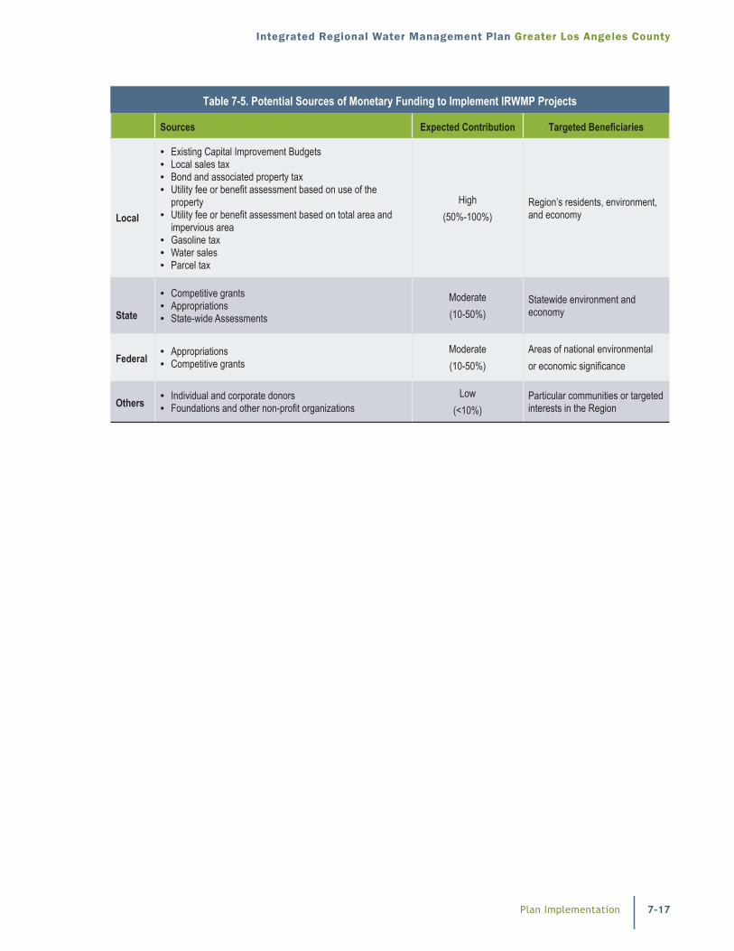
Local agencies and jurisdictions seeking federal funding opportunities and federal agencies may provide opportunities to fund IRWMP projects. While no definitive funding plan has been devel-oped to date; a description of potential funding sources for implementation of IRWMP projects is identified in Table 7-5.
Funding Plan
The GLAC Region has demonstrated a history of effectively managing the Region to promote the IRWM program goals. The GLAC Region is committed to continuing to providing the necessary resources to further both the O&M and Projects Programs of the IRWM. These resources will be provided by the LC and SC member agencies including those elected to serve as Chairs, Vice- Chairs and Administrating agencies/organization. These IRWMP agencies/organizations can only be elected into membership roles if they are willing to provide the necessary in-kind staff time as required to fulfill the activates described in the Plan.
If the Region wishes to pursue additional IRWM planning activities, a funding plan specific to those activities would be determined at that time.
The funding required to implement the projects included as part of the GLAC IRWM Plan is not described here since each project has its own unique funding plan. Projects cannot be included as part of the IRWM without a funding plan for their implementation. Current individual project funding information is available in the project database webpage (www.lawaterplan.org) as part of each project’s information report.
Plan Implementation
Integrated Regional Water Management Plan Greater Los Angeles County
7-17
Table 7-5. Potential Sources of Monetary Funding to Implement IRWMP Projects