Marine Geology, 116 (1994) 5-24 Elsevier Science B.V., Amsterdam 5 800-km-long N-S spreading system of the North Fiji Basin Manabu Tanahashi", Kiyoyuki Kisimoto", Masato Joshima", Philip Jarvis"*' , Yo Iwabuchib, Etienne Ruellan" and Jean-Marie AuzendedY2 "GeologicalSurvey of Japan, 1-1-3, Higaski, Tsukuba 305, Japan bJapaa Hydrographic Department, Maritime Safety Agency, 5-3-1, Tsukiji, C h o , Tokyo, 104, Japan 'Institut de Géodynamique, CNRS, Batiment 3, rue Albert Eiiistein, Sophia Antipolis, 06565 Valbonne Cedex, France dDépartei?ieiit Géosciences Marines, IFREMER, Centre de Brest, B. P. 337,29273 Brest Cedex, France (Received January 25, 1993; revision accepted July 1, 1993) ' ABSTRACT Tanahashi, M., Kisimoto, K., Joshima, M., Jarvis, P., Iwabucyi, Y., Ruellan, E. and Auzende, J.-M., 1993. 800-km-long N-S spreading system of the North Fiji Basin. In: J.-M. Auzende and T. Urabe (Editors), North Fiji Basin: STARMER French-Japanese Program. Mar. Geol., 116: 5-24. The 800-km-long N-S spreading system in the North Fiji Basin consists of six contiguous fan-shaped rift segments each 100-200 km long with various structural styles, such as structural overprinting, triple junction, rift-propagation, voluminous magmatism, and transform or strike-slip fault influence. Deformation of the plate boundary system within the young, hot, weak lithosphere occurred under local stress conditions resulting in a unique rift segmentation distinct from that of mid- oceanic ridges. Spreading across a series of short and variably oriented segments produces series of fanning spreading centers whose rotation pole is located at the end of each segment. The surrounding seafloor basement has adjusted to this setting with non-rigid deformation or with fragmentation. Furthermore, the changing tectonic framework caused by the arc rotation probably makes it difficult to keep the same stress condition for a long period. Small-scale fan-shaped sea-floor spreading is short-lived and results in a rapidly evolving plate boundary geometry. This suggests a more complicated tectonic style for marginal basins than mid-ocean ridge spreading centers. Introduction The tectonic style of the mid-oceanic ridges has been extensively surveyed in recent years and is well documented in excellent reviews (Sempéré and Macdonald, 1987; Macdonald et al., 1988; Kearey and Vine, 1990; Phipps Morgan, 1991; Solomon and Toomey, 1992; Sinton and Detrick, 1992). However, the tectonics of marginal basin forma- tion has not been considered in much detail, because of its extreme complexity. Even in one of the most active marginal basins, the North Fiji Basin, the existence of a linear spreading ridge has not been firmly established (Hamburger and 'Present address: Ocean Research Institute, University of Tokyo, 1-15-1, Minamidai, Nakano, Tokyo 164, Japan 'Present address: ORSTOM, Centre de Noumea, Boite Postale A 5, Noumea, New Caledonia hacks, 1988). We surveyed the central spreading system in the North Fiji Basin in the framework of the STARMER project and compiled swath bathymetry and magnetic anomaly maps. These represent a new view of the detailed tectonic style of the spreading system in this marginal basin. In this paper, we describe the topography and mag- netic anomaly fabric to outline the tectonic style of the 800-km-long N-S central spreading system of the basin. The tectonic interpretations based on the detailed magnetic anomaly data analysis are also discussed by Joshima et al. (1994-this issue) and Huchon et al. (1994-this issue). STARMER project and geophysical data of the North Fiji Basin The STARMER, Japan-France-SOPAC coopera- tive project, 1987-1992, was initiated to investigate 0025-3227/94/$07.00 0 1994 - Elsevier Science B.V. All rights reserved. SSDI O O 2 5 - 3 22 7 ( 9 3) E O O 92- K
800-km-long N-S spreading system of the North Fiji Basin
Manabu Tanahashi", Kiyoyuki Kisimoto", Masato Joshima", Philip Jarvis"*' , Yo Iwabuchib, Etienne Ruellan" and Jean-Marie AuzendedY2
"Geological Survey of Japan, 1-1-3, Higaski, Tsukuba 305, Japan bJapaa Hydrographic Department, Maritime Safety Agency, 5-3-1, Tsukiji, C h o , Tokyo, 104, Japan
'Institut de Géodynamique, CNRS, Batiment 3, rue Albert Eiiistein, Sophia Antipolis, 06565 Valbonne Cedex, France dDépartei?ieiit Géosciences Marines, IFREMER, Centre de Brest, B. P. 337,29273 Brest Cedex, France
(Received January 25, 1993; revision accepted July 1, 1993)
'
ABSTRACT
Tanahashi, M., Kisimoto, K., Joshima, M., Jarvis, P., Iwabucyi, Y., Ruellan, E. and Auzende, J.-M., 1993. 800-km-long N-S spreading system of the North Fiji Basin. In: J.-M. Auzende and T. Urabe (Editors), North Fiji Basin: STARMER French-Japanese Program. Mar. Geol., 116: 5-24.
The 800-km-long N-S spreading system in the North Fiji Basin consists of six contiguous fan-shaped rift segments each 100-200 km long with various structural styles, such as structural overprinting, triple junction, rift-propagation, voluminous magmatism, and transform or strike-slip fault influence. Deformation of the plate boundary system within the young, hot, weak lithosphere occurred under local stress conditions resulting in a unique rift segmentation distinct from that of mid- oceanic ridges. Spreading across a series of short and variably oriented segments produces series of fanning spreading centers whose rotation pole is located at the end of each segment. The surrounding seafloor basement has adjusted to this setting with non-rigid deformation or with fragmentation. Furthermore, the changing tectonic framework caused by the arc rotation probably makes it difficult to keep the same stress condition for a long period. Small-scale fan-shaped sea-floor spreading is short-lived and results in a rapidly evolving plate boundary geometry. This suggests a more complicated tectonic style for marginal basins than mid-ocean ridge spreading centers.
Introduction
The tectonic style of the mid-oceanic ridges has been extensively surveyed in recent years and is well documented in excellent reviews (Sempéré and Macdonald, 1987; Macdonald et al., 1988; Kearey and Vine, 1990; Phipps Morgan, 1991; Solomon and Toomey, 1992; Sinton and Detrick, 1992). However, the tectonics of marginal basin forma- tion has not been considered in much detail, because of its extreme complexity. Even in one of the most active marginal basins, the North Fiji Basin, the existence of a linear spreading ridge has not been firmly established (Hamburger and
'Present address: Ocean Research Institute, University of Tokyo, 1-15-1, Minamidai, Nakano, Tokyo 164, Japan 'Present address: ORSTOM, Centre de Noumea, Boite Postale A 5, Noumea, New Caledonia
hacks, 1988). We surveyed the central spreading system in the North Fiji Basin in the framework of the STARMER project and compiled swath bathymetry and magnetic anomaly maps. These represent a new view of the detailed tectonic style of the spreading system in this marginal basin. In this paper, we describe the topography and mag- netic anomaly fabric to outline the tectonic style of the 800-km-long N-S central spreading system of the basin. The tectonic interpretations based on the detailed magnetic anomaly data analysis are also discussed by Joshima et al. (1994-this issue) and Huchon et al. (1994-this issue).
STARMER project and geophysical data of the North Fiji Basin
The STARMER, Japan-France-SOPAC coopera- tive project, 1987-1992, was initiated to investigate
0025-3227/94/$07.00 0 1994 - Elsevier Science B.V. All rights reserved. SSDI O O 2 5 - 3 22 7 ( 9 3) E O O 9 2- K
6 M. TANAHASHI ET AL.
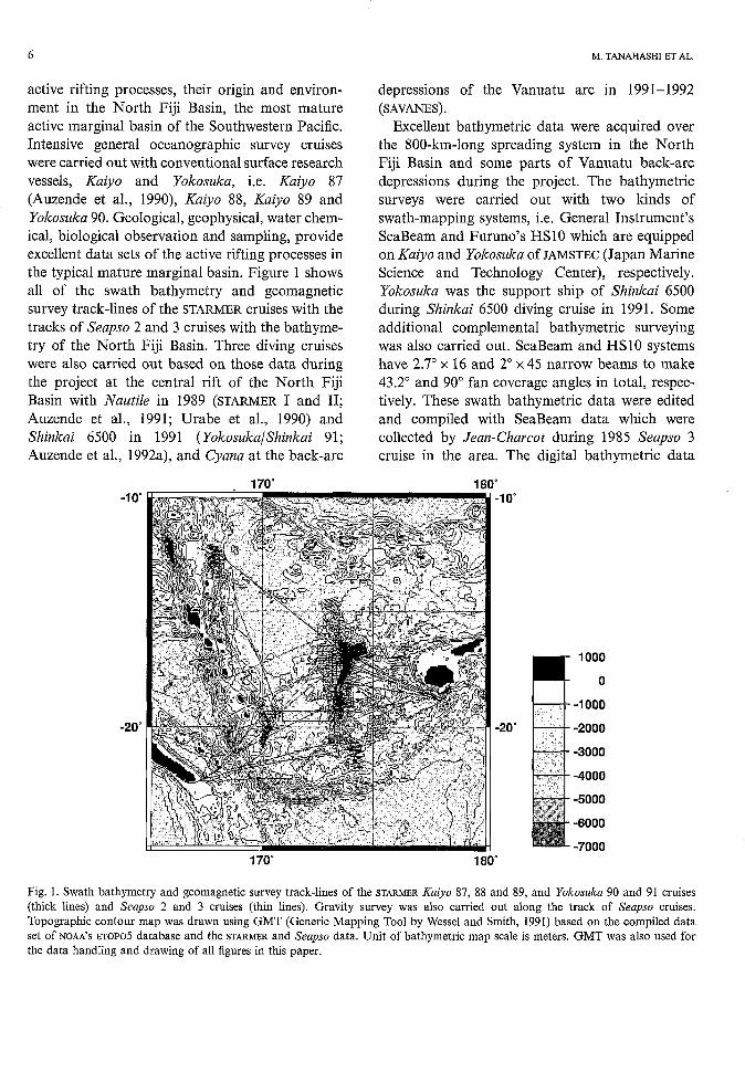
active rifting processes, their origin and environ- ment in the North Fiji Basin, the most mature active marginal basin of the Southwestern Pacific. Intensive general oceanographic survey cruises were carried out with conventional surface research vessels, Kaiyo and Yokosuka, i.e. Kaiyo 87 (Auzende et al., 1990), Kaiyo 88, Kaiyo 89 and Yokosuka 90. Geological, geophysical, water chem- ical, biological observation and sampling, provide excellent data sets of the active rifting processes in the typical mature marginal basin. Figure 1 shows all of the swath bathymetry and geomagnetic survey track-lines of the STARMER cruises with the tracks of Seapso 2 and 3 cruises with the bathyme- try of the North Fiji Basin. Three diving cruises were also carried out based on those data during the project at the central rift of the North Fiji Basin with Nautile in 1989 (STARMER I and II; Auzende et al., 1991; Urabe et al., 1990) and Shinkai 6500 in 1991 (Yokosuka/Shinkai 91; Auzende et al., 1992a), and Cyana at the back-arc
170" -loc
-20"
depressions of the Vanuatu arc in 1991-1992 (SAVANES).
Excellent bathymetric data were acquired over the 800-km-long spreading system in the North Fiji Basin and some parts of Vanuatu back-arc depressions during the project. The bathymetric surveys were carried out with two kinds of swath-mapping systems, i.e. General Instrument's SeaBeam and Furuno's HSlO which are equipped on Kaiyo and Yokosuka Of JAMSTEC (Japan Marine Science and Technology Center), respectively. Yokosuka was the support ship of Shinkai 6500 during Shinkai 6500 diving cruise in 1991. Some additional complemental bathymetric surveying was also carried out. SeaBeam and HSlO systems have 2.7" x 16 and 2" x 45 narrow beams to make 43.2" and 90" fan coverage angles in total, respec- tively. These swath bathymetric data were edited and compiled with SeaBeam data which were collected by Jean-Charcot during 1985 Seapso 3 cruise in the area. The digital bathymetric data
180" -10"
-20"
170" 180"
1 O00
O
-1 O00
-2000
-3000
-4000
-5000
-6000
-7000
Fig. I. Swath bathymetry and geomagnetic survey track-lines of the STARMER Kuiyo 87, 88 and 89, and Yokosuku 90 and 91 cruises (thick lines) and Senpso 2 and 3 cruises (thin lines). Gravity survey was also carried out along the track of Seupso cruises. Topographic contour map was drawn using GMT (Generic Mapping Tool by Wessel and Smith, 1991) based on the compiled data set of NOM'S ETOPOS database and the STARMER and Seapso data. Unit of bathymetric map scale is meters. GMT was also used for the data handling and drawing of all figures in this paper.
800-KM-LONG N-S SPREADING SYSTEM OF THE NORTH FIJI BASIN 7
compilation was mainly performed by Drs. Yo' Iwabuchi, Akira Asada (JHD: Hydrographic Department of Japan) and Takeshi Matsumoto (JAMSTEC). The first compilation map, which was hand-drawn by the cartographer based on digital data of Seapso 3 and Kaiyo 87 and 88, was published as a set of six sheet maps by IFREMER and STA with 1/200,000 scale, in 1989 (Auzende et al., 1989, 1990, 199213). The second compilation was completed and published with two sheets of 1/500,000 scale map, in 1992, at the end of the STARMER project, by JHD with Seapso 3, Kaiyo 87, 88 and 89, and Yokosuka 90 and 91 data. A lj750,OOO scale copy of the map set is supple- mented in this issue. The compiled digital data set allowed us to represent in various ways for the accentuation of the morphotectonic features of the complicated morphology of the spreading system of the basin. Figure 2 is the contour map of the central spreading system topography.
Conventional surface magnetic anomaly obser- vation with a proton magnetometer was carried out during Kaiyo 87, 88 and 89, Yokosuka 90 and YokosukalSlzirzkai 9 1 cruises. Those data were com- piled with the magnetic anomaly data of NOAA'S NGDC aeromagnetic database and GEODAS geo- physical cruise database which includes Seapso 3 and many cruises by ORSTOM, HIG, LDGO, SIO, WHOI and so on. Figures 3a and 3b are the contour and wiggle representation maps of the magnetic anomaly over the central spreading system, respec- tively. Analogue single channel seismic profiling was carried out during the Kaiyo 87, 88 and 89, and Yokosuka 90 cruises. As the sediment is quite thin around the active rifting area, it is useful for the identification and mapping young crustal regions which include the active rifting zones (Tanahashi et al., 1991).
The northern part of the spreading system and parts of the Fiji Transform fault have been mapped for the detailed structural fabric mapping with wide range sidescan sonar systems, SeaMARC II (Kroenke et al., 1991a,b,c) and GLORIA (Jarvis et al., in press). Gravity measurements were not obtained in the surveys of STARMER. Although the data were acquired during Seapso 3 and some other cruises, the density of available data is not comparable with bathymetric and magnetic anom-
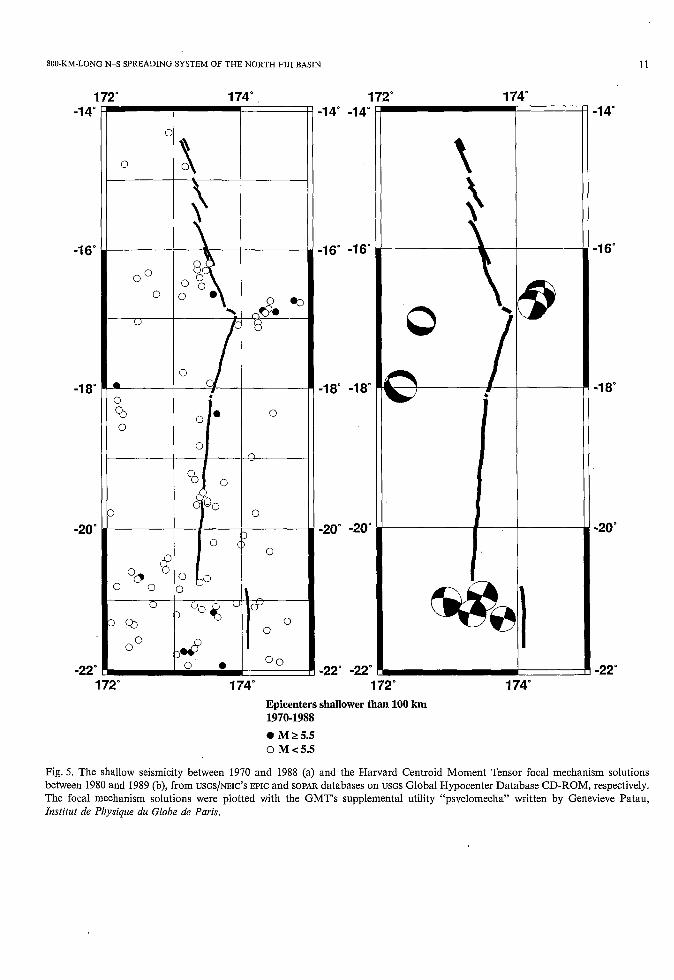
aly data (Fig. 4). Seismicity of the North Fiji Basin has been well reviewed and discussed by Hamburger et al. (1988), Hamburger and Isacks (1988) and Pelletier and Louat (1989). Further, the ISC catalogue of seismicity and several sets of focal mechanism solutions, which were released by USGS/NEIC with CD-ROM, provide a fundamental data set of the seismicity and seismotectonic condi- tion of the area (Fig. 5).
Tectonic framework of the North Fiji Basin
The Southwest Pacific convergence boundary, the Melanesian Borderland (Coleman and Packham, 1976), developed as a suture zone between the Indo-Australian and Pacifi ; Plates. Many marginal basins have been accreted and preserved in the boundary since the Late Cretaceous (Malahoff et al., 1982; Kroenke, 1984; Honza, 1991). There is a series of active marginal basins which have been developed since the Late Miocene or Pliocene in the boundary, i.e. Manus, Woodlark, North Fiji, and Lau-Havre basins, from north to south. The North Fiji Basin is the largest basin among them. It is bounded in the west by the Paleogene to Recent Vanuatu arc, which is accompanied by a trench in the west, and in the east by the Fiji islands platform, which is composed of Paleogene-Recent volcanic and mainly carbonaceous sedimentary sequences. The basin is bounded in the northeast by the Vitiaz paleo-trench, along which no active seismicity and volcanism are observed, and in the southeast by the Hunter Fracture Zone, which is composed of shallow ridges and makes a boundary between the young shallow North Fiji and the old deep South Fiji Basins. The size of the basin is about 1000 km x 1000 km and the area of the basin is therefore about 1,000,000 km'. The average water depth of the basin is about 3000 m. According to the NOAA~NGDC ETOPOS bathymetry data set, the northwestern part and central-eastern part have deep-smooth and shallow-rough topographic characters, respectively (Fig. 1).
The Wadati-Benioff zone along the Vanuatu arc dips east and continues distinctly down to 300 km. Peculiar seismicity deeper than 500 km concen- trates at 13"-15"s and 168"-173"E, and can possi-
8 M. TANAHASHI ET AL.
-1 4
-1 6'
-1 8
-20'
-22"
2" 174' -1 4"
-1 6"
-1 8'
-1 O00
-2000 -20
-3000
-4000
-5000 172" 174'
Fig. 2. Topographic contour map of the central spreading system of the North Fiji Basin based on 1 minute grid file compiled swath bathymetric data acquired during the STARMER and Seupso cruises. Unit of bathymetric map scale is meters.
bly be interpreted as a detached slab. The shallow seismicity of the basin (Hamburger and Isacks, 1989) shows (1) probable sinistral slip seismicity along the E-W Fiji Tranform Fault, which con- nects the northern end of Tonga Trench in the east to the central part of the North Fiji Basin, (2) dispersed seismicity interpreted as occurring along the NE-SW trending sinistral strike slip faults
which are widely distributed in the southern part of the basin, and (3) another E-W possible sinistral slip element is located along the Hazel-Holm Fracture Zone around 13"-155, 168"-173"E, the same region as the deep peculiar seismicity. Hamburger and Isacks (1989) doubted the exis- tence of the linear long spreading center in the North Fiji Basin comparable with the spreading
800-KM-LONG N-S SPREADING SYSTEM OF THE NORTH FIJI BASIN ' -
172' 174' -1 4"
-1 6"
-1 8"
-20"
-22' 172' 174"
14"
16'
~18'
-1 4'
-1 6"
-1 8"
172" +
800
600
400 -20' -20' 200
O
-200
-400
-600
-22 -800 -22 172" 174"
I ' ' I -2500 nT
9
t14'
-1 6"
-1 8"
-20'
-22"
Fig. 3. Magnetic anomaly contour (a: left) and profile (b: right) maps of the central spreading system of the North Fiji Basin. Contour map was drawn based on 1 mile grid file compiled STARMER, Seapso 3 data and NOAA'S aeromagnetic (Cherkis, 1980) and GEODAS database. Wiggle map shows STARMER and Seapso 3 data. Unit of magnetic anomaly contour map is nanotesla.
10
172" 174"
M. TANAHASHI ET AL.
-1 4'
-1 6'
-1 8'
-20"
-22 o
-1 4"
-1 6"
-1 8"
75
50 -20"
25
O
-25
-22" -50 172' 174"
Fig. 4. Free air gravity anomaly contour map of the central spreading system of the North Fiji Basin based on the and NOAA'S
GEODAS database which contains Seupso data. Anomaly unit is milligal.
system of the mid-oceanic ridges mainly based on the differences of these dispersed seismicity from the concentrated seismicity of the mid-oceanic ridges' spreading centers.
Pelletier and Louat (1989) presented an inter- pretation that the North Fiji Basin is divided into three microplates, i.e. the Western, Eastern and South North Fiji Basin Plates, and they interact
with the New Hebrides microplate and Pacific and Indo-Australian plates, based on seismic focal mechanism solutions and relative plate movement analyses. The central spreading system is located on the boundary of Western and Eastern North Fiji Basin microplate and Pacific Plate, in the south and north, respectively. The outstanding linearity of the topography and the magnetic
800-KM-LONG N-S SPREADING SYSTEM OF THE NORTH FIJI BASIN
O
O
1 -1 4"
-16-
-1 8"
-20"
-22'
1 !" 174"
q O0 O 0 0 % \
O
n
O
O
- Y
O o
172" 174"
-14" -14"
-16' -16"
-18' -18"
-20" -20'
-22" -22'
172" 174"
O I
i
172" 174' Epicenters shallower than 100 km
0 M 2 5.5 0 M c 5.5
1970-1988
11
-1 4'
-1 6"
.I 8'
-20"
-22'
Fig. 5. The shallow seismicity between 1970 and 1988 (a) and the Harvard Centroid Moment Tensor focal mechanism solutions between 1980 and 1989 (b), from USGS/NEIC'S EPIC and SOPAR databases on USGS Global Hypocenter Database CD-ROM, respectively. The focal mechanism solutions were plotted with the GMT's supplemental utility "psvelomecha" written by Genevieve Patau, Institut de Physique du Globe de Paris.
12 M. TANAHASHI ET AL.
anomaly of the central spreading center revealed that the spreading system is of comparable dimen- sion as the mid-oceanic ridge spreading system. Thus, the tectonic complexity of these several microplates' interaction probably causes the dis- persed seismicity which Hamburger and Isacks (1989) have noticed.
The North Fiji Basin is the most mature active marginal basin in the present back-arc environ- ment. It is important for the discussion of the origin of the marginal basins wider than linear backarc troughs as the Okinawa, Bonin, Mariana, Vanuatu back-arc, and Lau-Havre Troughs along present active island arcs. Most mature marginal basins have ceased spreading activity such as the Kuril, Japan, West Philippine, Shikoku, Parece Vela, South China, Coral Sea, New Caledonia, South Fiji, and Tasman Basins.
Geologic phenomena of the central spreading system of the North Fiji Basin
An active hydrothermal chimney ("White Lady"), Station 4 at the 17"S, 174"E triple junction is the most outstanding feature revealed during these surveys (Auzende et al., 1991). The chimney is located in the hydrothermal field in the 2 km wide axial graben of the volcanic high which is located in the triple junction. It expels clear hydro- thermal water, 285°C in maximum measured tem- perature. The chemistry of the sampled water suggested that it was condensed from the boiled fluid in the subsurface (Grimaud et al., 1991). It consists of a pure-white sulfate chimney on the sulfide mound in a broad hydrothermal field of the thinly sedimented fresh sheet lava area. Hydrothermally supported fauna are thriving around the chimneys. The active hydrothermal activity persisted for two years between two diving cruises (Auzende et al., 1992a).
Another active but diffuse, low temperature hydrothermal field is developed in the narrow, 10 to several tens of meters wide, axial depressions in the lava plain over the nearly flat 7-10 km wide top of the ridge at site Station 14, 18"50'S, 173'30'E (Auzende et al., 1991). Although the hydrothermal activity does not construct chimneys in fresh lava lakes, its fertility supports considerably large bio-
logic colonies in this field. An anomalous chemical signature in the water column was observed during Kaiyo 87 cruise and interpreted as a part of a megaplume (Nojiri et al., 1989). The abnormally thin (about 3-4 km) crust was observed at this site in the refraction seismic survey with OBSH (Ocean Bottom Seismometer and Hydrophone) and sono- buoys (Tanahashi et al., 1991; Kisimoto et al., 1994-this issue).
Two large-scale dead sulfide chimney forests were discovered in the north of Station 4 (Auzende et al., 1991) and in the south of Station 14 (Auzende et al., 1992a). They suggest intense his- torical, possible black smoker type, hydrothermal activity along the spreading center.
The petrology of basalts which were sampled from the central spreading center south of the triple junction at 17"s shows that N-MORB is predominant (Eissen et al., 1991; Hirose et al., 199 1). In contrast, Hirose et al. (1 99 1) showed that the part of the basalts which were recovered from the northern limb of the 17"s triple junction has some enriched character and suggested that the enriched basalts were segregated from a lower temperature enriched mantle source deeper than the depleted basalts found in the southern limb of the triple junction.
Bathymetric and geomagnetic data of the North Fiji Basin spreading system
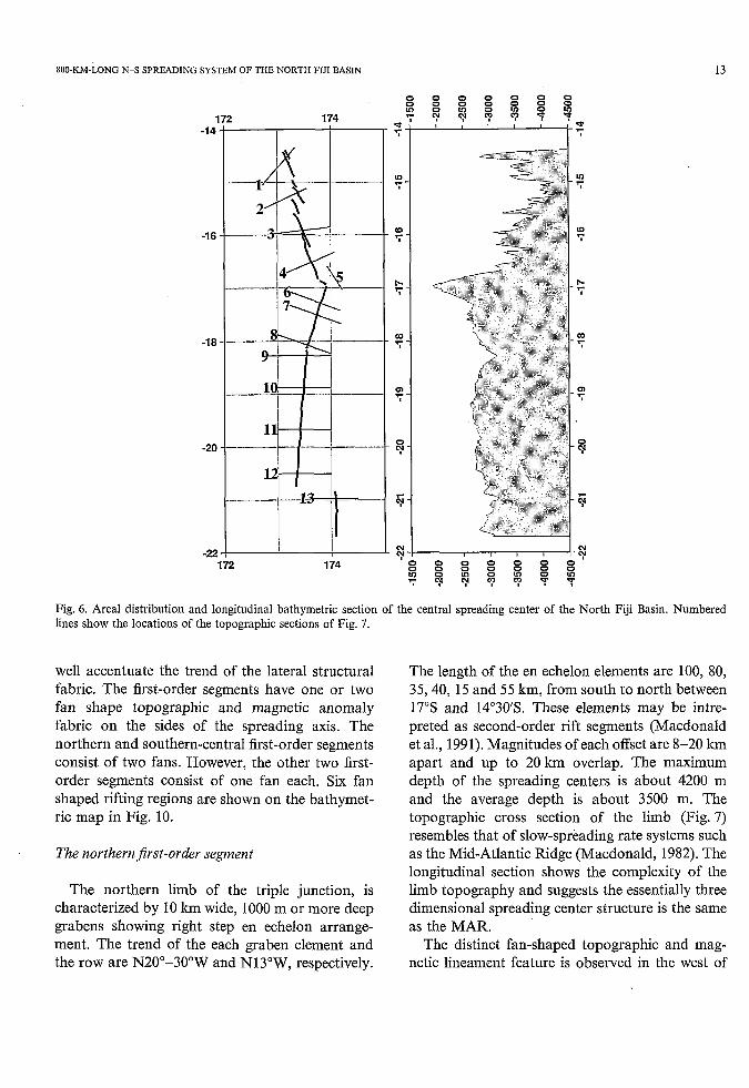
The trace and the longitudinal topographic sec- tion of the North Fiji Basin central spreading center are shown on Fig. 6 . The topographic cross sections are shown on Fig. 7. According to the concept of hierarchy of rift segmentation by Macdonald et al. (1988, 1991) and Grindlay et al. (199 l), we interpreted the central spreading system of the North Fiji Basin is principally divided into four first-order segments, i.e. the northern, northe- rn-central, southern-central and southern seg- ments. The junctions of these segments are the triple junction, a possible propagating rift, and some 75 km offset of the spreading centers. The profile representation on E-W sections of maps of the topography (Fig. 8) and the magnetic anomaly distributions (Fig. 9) using 1 mile grid data of the central spreading system of the North Fiji Basin
SOO-KM-LONG N-S SPREADING SYSTEM OF THE NORTH FIJI BASIN 13
1 -1 4
-1 6
-i a
-20
-22
0 0 0 0 0 0
8 8 8 8 8 8 y y : y T y
174 0 0 0 0 0 0 0 8 8 8 8 8 8 8 T T B T T V V
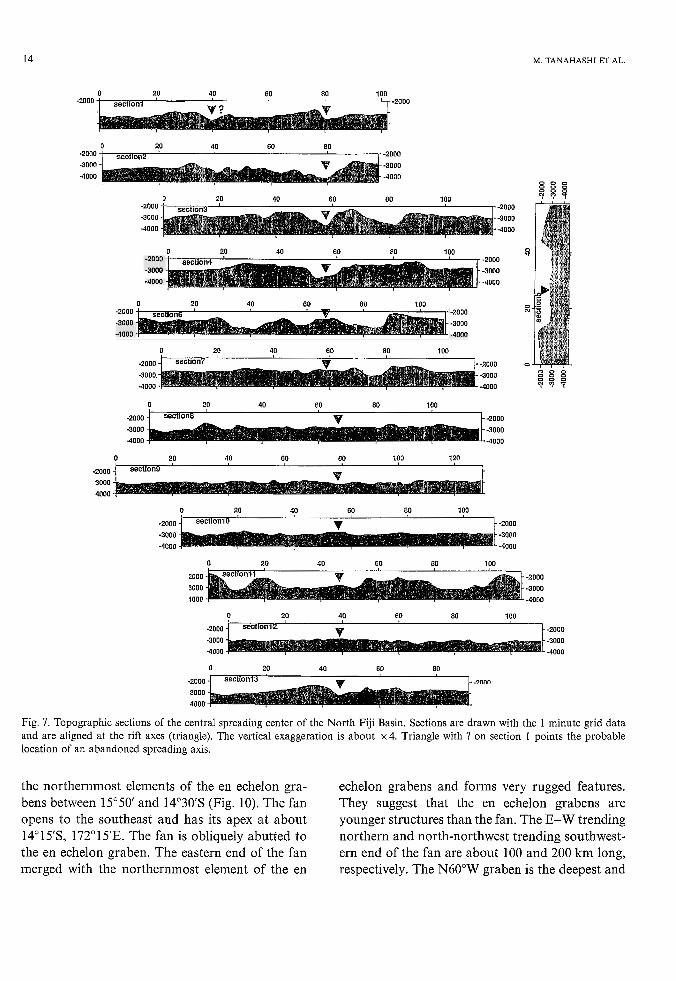
Fig. 6 . Areal distribution and longitudinal bathymetric section of the central spreading center of the North Fiji Basin. Numbered lines show the locations of the topographic sections of Fig. 7.
well accentuate the trend of the lateral structural fabric. The first-order segments have one or two fan shape topographic and magnetic anomaly fabric on the sides of the spreading axis. The northern and southern-central first-order segments consist of two fans. However, the other two first- order segments consist of one fan each. Six fan shaped rifting regions are shown on the bathymet- ric map in Fig. 10.
The northeni$rst-order segment
The northern limb of the triple junction, is characterized by 10 km wide, 1000 m or more deep grabens showing right step en echelon arrange- ment. The trend of the each graben element and the row are N2Oo-3O0W and N13"W, respectively.
The length of the en echelon elements are 100, 80, 35,40, 15 and 55 km, from south to north between 17"s and 14"30'S. These elements may be intre- preted as second-order rift segments (Macdonald et al., 1991). Magnitudes of each offset are 8-20 km apart and up to 20 km overlap. The maximum depth of the spreading centers is about 4200 m and the average depth is about 3500 m. The topographic cross section of the limb (Fig. 7) resembles that of slow-spreading rate systems such as the Mid-Atlantic Ridge (Macdonald, 1982). The longitudinal section shows the complexity of the limb topography and suggests the essentially three dimensional spreading center structure is the same as the MAR.
The distinct fan-shaped topographic and mag- netic lineament feature is observed in the west of
14
O 20 40 60 80 100 t , -2000 -zoo' i section1 ' --
M. TANAHASHI ET AL.
a 20 40 60 80 I. -2000
O 20 40 60 80 1 O0
O 20 40 60 80 1 O0 o -2000 -2000
-4000 -4000
-3000 -3000
O 20 40 60 80 100 -2000 -2000
-3000 -3000
-4000 -4000
w
O 20 40 60 80 100
-2000 -2000 o B Z X -3000 -3000
-4000 -4000 B l ' f O 0 0
O ao 40 60 80 100
-2000 -2000
-3000 -3000 -4000 -4000
O 20 40 60 80 100 120
-2000 section9 c .... .
O 20 40 60 80 100
O 20 40 60 80 100
-2000 -2000 -3000 -3000 -4000 -4000
O 20 40 60 80
.2000 C m n n section13
Fig. 7. Topographic sections of the central spreading center of the North Fiji Basin. Sections are drawn with the 1 minute grid data and are aligned at the rift axes (triangle). The vertical exaggeration is about x 4. Triangle with ? on section 1 points the probable location of an abandoned spreading axis.
the northernmost elements of the en echelon gra- bens between 15'50 and 14'30s (Fig. 10). The fan opens to the southeast and has its apex at about 14"15'S, 172'1 SE. The fan is obliquely abutted to the en echelon graben. The eastern end of the fan merged with the northernmost element of the en
echelon grabens and forms very rugged features. They suggest that the en echelon grabens are younger structures than the fan. The E-W trending northern and north-northwest trending southwest- ern end of the fan are about 100 and 200 km long, respectively. The N60'W graben is the deepest and
800-KM-LONG N-S SPREADING SYSTEM OF THE NORTH FIJI BASIN
172' 174" -1 4"
-1 6'
-1 8"
-20"
-22"
I I -1 4"
-1 6"
-1 8"
-20"
-22" 172" 1 74" -
+3000 m -3000 m -9000 m
Fig. 8. E-W profile representation of the topography of the central spreading center of the North Fiji Basin from the 1 minute grid data. Areas those are shallower and deeper than the base depth (3000 m) are drawn in black and white, respectively.
15
most distinct feature inside of the fan and is seemingly a central, ceased spreading axis (Fig. 7) of the fan.
A 55 km long 5 km wide narrow ridge, which runs slightly east of the graben between 14'50' and 14"30'S with N40"W trend, 15" more westerly trend than those en echelon grabens, intersects and overlaps with the graben at its northern part. The ridge is accompanied with a parallel deep and another ridge in the east. The overlapping feature of the ridge on the graben suggests the ridge is a younger structure than the en echelon graben.
The southern two grabens of the en echelon array, between 15'30' and 17"S, are bounded by topographic highs up to 100 km wide in the south, and narrow to the junction with the northern fan at the northern end (Fig. 10). This part made another fan structure whose length is about 200 km. It is suggested from the single-channel seismic profiles that the graben and highs, which show sediment free character, cut into the consider- ably thickly sedimented older seafloor (Tanahashi et al., 1991). The magnetic anomaly pattern of the fan shows distinct linear trends over the highs adjacent 70 the central grabens. The center of the graben corresponds to the negative anomaly zone between those anomalies over the highs. Joshima et al. (1994-this issue) suggest that the spreading activity along this limb stopped during Matuyama reverse period, and is resting or is just commencing the renewal activity. Some geochemical anomalies and the existence of the fresh neovolcanic zone (Auzende et al., 1988a, 1992a; Gràcia-Mont et al., 1994-this issue) suggest there is rejuvenated spread- ing activity. The western magnetic lineation is more distinct than the eastern one, and it twists 15" clockwise at the junctions of two grabens (Figs. 3 and 9). The junction separated the fan into two parts. Relatively high seismicity is also observed in this junction (Fig. 5). The southern part of the fan is wider than the linear trend of the northern part, i.e. the western border of the fan shows an arcuate bend to west.
This new southern fan apparently overlaps the old northern fan. It may be a northward propagat- ing rift penetrating into old basement. The north- ern fan may be an older propagated rifting segment which has ceased its spreading activity. This class
16 M. TANAHASHI ET AL.
172" 174" -1 4"
-1 6"
-1 8"
-20"
-22"
-1 4"
-1 6"
-1 8"
-20'
-22" 172" 174"
u -5000 nT Fig. 9. E-W profile representation of the magnetic anomaly of the central spreading center of the North Fiji Basin from the 1 minute grid data. Positive and negative data are drawn in black and white, respectively.
172" 174" -1 4"
-1 6"
-1 8"
-20"
-22'
-14"
-16"
-18"
-20"
-22" 172" 174"
+3000 m -3000 m
Fig. 10. Distribution of the fan shaped segments (gray lines) and axis traces (white lines) of the central spreading system of the North Fiji Basin drawn over the topographic map (Fig. 8).
SOO-KM-LONG N-S SPREADING SYSTEM OF THE NORTH FIJI BASIN 17
of "propagation" makes fan spreading basement which usually requires non-rigid deformation or the fragmentation of the surrounding basement, and differ from Hey's (1977) propagating rift model which fundamentally assumes the rigid plate hypothesis.
The triple junction
The junction between the northern and northe- rn-central first-order segments is the triple junction which consists of the north-northwestern limb of the graben, the east-northeastern limb of 35 km wide graben which wedges into the east and contin- ues possibly to the Fiji Transform Fault, and a south-southwestern active spreading ridge. There is a large-scale topographic high at the triple junction. The geologic description and tectonic interpretations were given by Lafoy et al. (1991) and Tanahashi et al. (1991). The topographic highs, which have distinct sharp cliffs as the boundaries of the NE-SW graben in which the present topo- graphic high is located, are possibly composed of split and a dismembered volcanic high at the old triple junction (Tanahashi et al., 1991). The NE-SW graben narrows to the east and possibly continues to the sinistral Fiji Transform Fault. Several low relief ridges run from the triple junc- tion to the north on the graben floor and are interpreted as possible propagating ridges (Lafoy et al., 1991). There are E-W trending sinistral focal mechanisms located along the graben bound- ing faults (Fig. 5). However, there is an E-W trending dextral fault mechanism given for the M5.4 earthquake in February, 1970 by Eguchi (1984) and this is interpreted as the transform movement between the west-northwest and south- southwest limbs of the junction (Tanahashi et al., 1991). Earthquakes with west-northwest trending normal fault type mechanisms to the west of the triple junction suggest complex intraplate deformations.
The northern-central first-order segment
The south-southwestern (N1 5"-2O"E) limb of the triple junction is characterized by a fairly smooth, southward deepening floor with a bend at
17'20's and the bulge at around 17'40's on the longitudinal topographic section (Fig. 6). The northern end of the segment, the volcanic high at the triple junction, is conspicuously high along the spreading system. It suggests the dual origin of the high with the along axis 2-D volcanism and point source volcanism at the triple junction which may be supplied from a deeper source than the along axis volcanism. The split, dismembered highs, which surround the northeastern graben, suggest such volcanism in a previous tectonic stage.
The cross section 6 (Fig. 7) shows a 12 km wide 500 m high ridge with a 2 km wide 100 m deep axial graben. It resembles intermediate and fast- spreading rate systems such as the East Pacific Rise (Macdonald, 1982). But, section 7 shows a more ambiguous ridge and axis structure even only 25 km south from the position of section 6. Section 8 at the southernmost part of the segment shows an almost flat profile. The spreading axis trace of the southern part of the segment is not as clear in the plan view. This wide, low-topography profile possibly corresponds to a high spreading rate with insufficient magmatic supply.
Ridges and troughs along the axial graben are developed within a 60 km wide graben. The graben is apparently the continuation of the northeastern graben of the triple junction. The eastern boundary fault sharply cuts the elongated high from the east of the triple junction. It shows an arcuate trace with two westerly concave forms. The topographic lineaments east of the boundary shows N-S trend. The western boundary of the graben shows an easterly concave structure in the western part of the triple junction and less distinct topography in the southern part of the segment. The seafloor west of the boundary shows mainly a NE-SW trend of wide structure and some N-S trend lineaments.
The lineaments of the ridges and troughs collec- tively show a fan shape pattern. The fan has about a 25" opening with the pivot at around 16'54's and 173'53'E. The lineaments of ridges far from the axis on both sides show a more easterly trend (N25"E) than the axis trend. The 20 km wide axial region apparently changed direction westerly and overlapped on the older structure. The magnetic anomaly pattern also suggests that the spreading
18 M. TANAHASHI ET AL.
axis jumped to the east of the graben. The center of the positive magnetic anomaly along the axis in the southern part of the segment lies in the west from the axis.
The junction of the overlapping spreading center and the propagating rift
The topographic fabric of the junction between the N15"-20"E northern-central and N5"E southe- rn-central first-order rift segments shows a V-shape geometry, which suggests a spreading direction adjustment with the northward rift propagation (Hey, 1977). The longitudinal topographic profile along the spreading axis shows a 400 m deeper depression than the main parts of northern- and southern-central segment axes. A high-amplitude positive magnetic anomaly, which characterizes the tip of propagating ridges (Hey et al., 1986), is observed at the tip of the southern-central rift segment.
The traces of the ridges to the west of the junction curve to east in the southernmost part of the northern-central fan segment. Although some traces in the east of those arcuate structures appa- rently continue to the lineament in the north, some arcuate structures in the southwestern part are isolated from the lineament parallel to the present axis. The southern end of the arcuate structures are cut by the N33"E trending structures which is a possible inner pseudofault. The N15"W trending possible outer pseudofault structure is observed in the boundary of the segments in the east of the axis. These boundaries consist of the sides of the southward opening fan structure of the southern- central spreading segment. Isolated arcuate ridges resemble the self-decapitated overlapping ridges recognized in the East Pacific Rise (Macdonald et al., 1988; Carbotte and Macdonald, 1992). The series of arcuate structures makes a junction struc- ture with the N-S trending central-south segment. De Alteriis et al. (submitted) interpreted the junc- tion as the overlapping spreading center with the intermittent propagation from the south to north. The arcuate structures are interpreted to be decapitated at the propagation episode.
The southern-central first-order segment
The N-S spreading center has the most charac- teristic structural features of a spreading center. The segment shows distinct linearity on the mag- netic and topographic maps.
The NS"E-trending, broad, central magnetic anomaly (Figs. 3a and 9) which narrows to both north and south ends and makes two fan regions whose axes are interepreted as second-order rift segments (Macdonald et al., 1991), characterizes the magnetic structure of the segment. A clear 5-8 km wide, narrow, positive axial line is observed within a broad small negative or near-zero anom- aly zone which is bordered by the positive anomaly. It is interpreted the axial line as the fresh neovol- canic zone, the near-zero zone as the homogeneous normal magnetized and partly weathered demagne- tized zone, and the marginal positive zones as the eastern and western margins of N-S trending normal magnetized block, respectively. The inter- preted normally magnetized zone is estimated to have spread during the Brunhes normal period (younger than 0.78 Ma; Spell and Mcdougall, 1992). The narrow positive anomalies, which are well observed outside of the broad positive zone between 18"20' and 19"1O'S, are interpreted as the Jaramillo zones. The weak magnetic anomaly region in the central anomaly is developed between 19"40' and 19'55's. The region corresponds to the area where volcanic chains are developed. This region divides the segment into northern and southern fans.
The topographic map and cross section in the northern fan shows a 10-15 km wide axial bulge with 4-6 km wide flat top without a distinct axial graben. It resembles the bathymetry of the fast- spreading center such as East Pacific Rise (Macdonald, 1982). The diving survey revealed axial depressions in the fresh sediment-free col- lapsed lava lake which characterizes the axial region (Auzende et al., 1992a). The depressions are a few tens of meters wide and a few meters deep.
The longitudinal topographic profile along the axis of 19"-19"3O'S shows the most developed swell which deepens to the north. There is an overlapping spreading center (OSC; Macdonald et al., 1984) at 19"s. The size of the overlapping
800-KM-LONG N-S SPREADING SYSTEM OF THE NORTH FIJI BASIN 19
basin is 2 km and 6 km in width and length,. respectively. The western ridge, which probably was the tip of the southern segment, is almost decapitated. The estimated sense of offset was right step. The 30 km long, N8'E third-order segment south of the 19' OSC has the most voluminous bulge. The southern end of the third-order segment is defined by another OSC at 19'19's. The OSC shows 2 km left step and 3 km ridge overlap. The 35 kin long, N5'E third-order segment south of 19'19's OSC has a flat top as the northern part of the southern-central segment. The southern end of the N5'E third-order segment is a topographic low several tens of meters deep at 19'37's. The offset at the depression is not obvious.
The complex topography observed in the area between 19'40's and 20's corresponds to the weak magnetic anomaly region at the junction of two fans. The trace of the axis is less clear and the axial domain is fragmented into some short third- or fourth-order segments. Another 11 km long and 3.5 km wide small overlapping basin (Auzende et al., 1988a) is observed on the axis at 19'50's. The OSC is a topographic low about 100 m along the segment axis and the most prominent one among the OSCs in the southern-central segment (Fig. 6). The OSC with regional topographic low suggests the portion behaves non-rigidly with rela- tively low magma-productivity and fast-spreading rate (Macdonald et al., 1988).
This region is the junction of the N-S spreading center and several characteristic volcanic chains which are developed on both sides of the axis, aligned to the axis at near right angles, and curve north diverging from the axis to be almost parallel to the spreading axis. The volcanic chains are composed of some isolated or semi-isolated conical highs. They are also developed in the northern part of the segment. Although the chains meet at the zone, they do not show a symmetry. There is no apparent volcanic chain element on the present bulge, but the volcanic chain is apparently pro- duced at near off-axis. Assuming the magmatic source is anchored below the asthenosphere, the arcuate volcanic chain trace may suggest that the absolute motion of the segment is northward and decreasing such component or increasing spreading rate. It suggests that the source of the volcanic
chains has some mantle plume nature. Although the bulge along the spreading segment axis is less developed than the northern part, the width of the possible Brunhes anomaly zone is largest in this segment. It suggests that this portion is the most active area of magmatic supply and a center of some mantle upwelling. Relatively high seismicity is observed in this junction (Fig. 5). Along axis 2-D magmatic supply in this junction apparently seems to be less than in other parts because of the high spreading rate. The deficiency of magma for plate accretion may be compensated by the upwell- ing of deeper source magma. And upwelling itself may be the origin of the high spreading rate of this junction.
The southern fan has a less developed axial bulge than the northern one. It is split into two, makes a clear axial graben at 20°40'S, and the bulge is indistinct. There is a parallel or semi- parallel series of low profile ridges and troughs along the axis (Fig. 7). On the western side, those trends bend to the possible point of the southern end of the spreading segment. However, on the eastern side, the trends are almost parallel to the axis and are cut by a northeast or east trending zigzag trough. The trough marks the northwestern margin of the junctional structure between the southern-central and southern first-order spread- ing segments.
75 k m offset between southern-central and southern firs t-order seginen t
The boundary area between the southern-central and southern first-order rift segments was not very well mapped. If the interpreted axis location of the southern segment is correct, the offset is about 75 km which shifts the southern segment to the east. The topography of the boundary region is roughly northeast trending, but it shows some 3-D features. Some focal mechanism solutions around here are interpreted as the northeast trending sinistral strike-slip faults (Hamburger and hacks, 1988) along the boundary trend. There is a 35 km wide set of three positive and two negative N50"-55"E magnetic anomaly lineations in the east of the southern tip of the southern-central segment. It may suggest that the boundary corres-
20 M. TANAHASHI ET AL.
ponds to a kind of spreading structure such as a leaky transform fault. Alternatively, there is a possibility that the magnetic lineation set corres- ponds to transferred lithosphere between propagat- ing and doomed rifts (Joshima et al., 1994-this issue).
The southern first-order segment
Although the segment was not well mapped and the structure of.the western part is not clear, a N-S trending, 4 km wide and 500 m deep graben along 174"E is interpreted as a spreading center based on the positive magnetic anomaly along it. Although the seismicity is fairly active around the segment, the spreading activity is not confirmed. North-northeast magnetic and topographic linea- ments in the eastern side of the axis are developed 174'20-30'E and suggest a northward opening fan structure whose pivot is located at around 21 "55's and 174"OSE. The fan seems to be cut by the northeast fault obliquely in the northern end.
Tectonic style of the North Fiji Basin spreading center
The central spreading center of the North Fiji Basin is interpreted to be segmented into four first- order segments. The northern segment consists of two southerly opening fans whose axes are oblique. The segment has a deep graben profile like the Mid-Atlantic Ridge. The northern-central segment has one southerly opening fan. The southern- central segment has two fans, whose pivots are in the northern and southern ends. The junction between the two fans has a peculiar complicated structure including overlapping spreading centers. It suggests large scale magmatism in the junction which is the most rapidly spreading region. The southern segment has a northerly opening fan whose axis is the deep graben of the northern segment.
The total system roughly defines a single N-S trending spreading system. The segments of the system each have different trends. They have dis- tinctive fan-shaped magnetic lineation and topo- graphic lineament patterns. The fan-shaped lineation sets suggest a semi-rigid nature of the
plate movements. They suggest a large contrast of the spreading rate from the pole to another end of the segment. They also require the substantial intra-plate deformations in the surrounding base- ment. When the all spreading center adjustments were performed rigidly, the propagating rift traces with fundamentally parallel lineations should be more distinct. There is a unique junction structure of rifts at the 18"s of the North Fiji Basin spreading system. It is interpreted as the junction of the northward propagating ridge and the end of the northern fan spreading ridge. The propagating ridge is interpreted to be developed as an intermit- tent overlapping spreading and propagating rift (De Alteriis et al., submitted). It suggests that the rigid nature of the surrounding plate is less distinct than that of the mid-ocean ridge propagating rift region.
The segmentation of the North Fiji Basin rifts probably reflects both a magmatic source segmen- tation, which is suggested at the mid-oceanic ridges (Macdonald et al., 1988) and the complexity of the surrounding micro-plates as well. The variabil- ity of the rift trends probably reflects the response of non-rigid microplates to the motion of sur- rounding major plates. Even at the mid-oceanic spreading ridges the propagating short curved ridges can occur along the margins of the micro- plates deforming with the rotation, such as the Easter (Naar and Hey, 1991) and Juan Fernandez (Larson et al., 1992) microplates.
Transform faults are not well developed in the central spreading system of the North Fiji Basin. The sinistral motion of the area between the Pacific and Indo-Australian plates probably guides the Hunter fracture zone and the Fiji Transform Fault as the major sinistral transform faults. A short offset between the northern segment and northern- central segment could be interpreted as dextral transform fault (Tanahashi et al., 1991) based on the geometry and the seismic focal mechanism solution (Eguchi, 1984).
There is a 75 km-offset between southern-central and the southern segment. It is interpreted as a reactivated fault which was developed as a trans- form fault during an initial opening phase by Auzende et al. (1988b). In contrast, Pelletier and Louat (1991) interpreted the structure as the sinis-
800-KM-LONG N-S SPREADING SYSTEM OF THE NORTH FIJI BASIN 21
tra1 transform fault which bounds the Indo- Australian and western North Fiji Basin plates. Maillet et al. (1990) interpreted that the southern- central segment propagates to the south, the east- erly offset southern segment is a dying rift, and the offset structure as the dextral transform zone. Now, we know that the boundary zone has a parallel magnetic lineation set, and that the south- ern end of the southern-central segment has a fan shape and not a simple propagating ridge structure. The focal mechanisms at the structure, N20"E sinistral or N70"W dextral, and the possible direc- tion of the faults, N60"E, may suggest the structure is a sinistral strike-slip fault. The offset structure may be interpreted as a sinistral synthetic strike- slip fault of the Hunter Fracture Zone, instead of a dextral transform fault.
Lack of other transform faults along this 800 km long spreading system suggests that the spreading system is less rigid than that of the mid-oceanic ridges. Faster spreading ridges have less transform faults (Sandwell, 1986) and non-rigid struc- tures such as the overlapping spreading center (Macdonald et al., 1984). The spreading rate along the central spreading system is not so high, if the interpretation of the Brunhes normal zone is cor- rect. The half-spreading rate of the North Fiji Basin spreading system is interpreted up to 3.52cm/yr at the center of the southern-central segment. The topographic resemblance of the southern-central segment to the fast-spreading system is possibly interpreted as the result of less rigidity of the basin than the typical oceanic litho- sphere. The lack of transform faults between fan regions requires the rotation pole of the spreading near the end of the segment. It makes the large production rates contrast between the pole and another end of each spreading segment.
The whole North Fiji Basin is supposed to be younger than about 10 Ma (Auzende et al., 1988b). And the.heat-flow data in the basin is higher than that in East Pacific and the Indian Ridges on the same age crust (Recy and Dupont, 1982), and the crustal thickness is about 3-5 km (Kisimoto et al., 1994-this issue). It is thinner than average oceanic crust of 6-7 km. The widely dispersed seismicity is observed and the tectonic environment is com- plex. This results in non-rigid behavior of the
North Fiji Basin plate lithosphere. The distinct linearity of the spreading segments fundamentally supports rigid plate tectonics rather than the diffuse spreading style proposed by Hamburger and Isacks (1988).
As Hamburger and Isacks (1988) suggest, the pull-apart stress condition and continuous modifi- cation of the tectonic framework with the rotation of Vanuatu arc and Fiji platform probably produce the dispersed many weak parts within the basin. Tensile stress caused by the pull-apart tectonics and possible mantle upwelling make some distrib- uted fractures in the basin. The fractures will be connected with the propagation and make a net- work of short spreading segments with various directions. Then each short segment spreads to produce rigid platelets which rotate around an end of the segment. The surrounding older plates will be deformed rigidly by fragmentation and/or non- rigidly. At the extent of the deformation accommo- dation of those surrounding plates, the fan spread- ing of the segment with the rotation of platelet will be ceased. Other segments may continue to spread and propagate to the old plates to modify the spreading system geometry. This tectonic stage probably corresponds to the present North Fiji Basin spreading system.
Conclusion
It is interpreted that the complex stress environ- ment and non-rigid nature of the young, hot, and weak micro-plate lithosphere of the North Fiji Basin possibly controls the complicated tectonic style of its central spreading system.
Rigid seafloor spreading along the relatively short segments with various directions produces series of fan spreading systems. But the fan spread- ing systems, which have large spreading rate con- trasts along the segment, cannot persist for a long period of time. When the contradiction between the produced plates and the surrounding plate deformation along the spreading system reached a limit, the spreading center activity ceased. Such contradiction is emphasized by the continuously changing basin framework including the Vanuatu arc and Fiji platform rotations caused by the major plates interaction. The driving force for the basin
22 M. TANAHASHI ET AL.
spreading such as the pull-apart stretching of the basin or some contribution by the anchored magma supply will produce a new spreading system along the weakest lines of the surround- ing plates.
This kind of structural style is possibly common for the most of the marginal basin development, because they were developed generally as short lived young, hot lithosphere under a complex stress environment as the North Fiji Basin.
Acknowledgements
The STARMER project is funded by the Science and Technology Agency, Japan and IFREMER, France. This study was performed using the Special Coordination Funds for Promoting Science and Technology of the Science and Technology Agency of the Japanese Government.
We are grateful to the executive and scientific committees of the programme. We are also grateful to captains, crews and technical staff of Kaiyo, Yokosuka, Nadir, Nautile, Dolphin3K and Slzinkai6500. Discussion and cooperation with our Co-researchers of the STARMER project, specially, Drs. Eiichi Honza and Tetsuro Urabe of Geological Survey of Japan, Drs. Takeshi Matsumoto, Jiro Naka, and Takeo Tanaka of Japan Marine Science and Technology Center, Drs. Patrick Maillet and Jean-Philip Eissen of ORSTOM are very helpful and also greatly thanked. We also wish to thank to Drs. Jeffrey A. Karson, Duke University, and Ken C. Macdonald, University of California, Santa Barbara, for their critical reading of the manuscript and useful comments.
References
Auzende, J.-M., Eissen, J.-P., Lafoy, Y., Gente, P. and Charlou, J.L., 1988a. Seafloor spreading in the North Fiji Basin (southwest Pacific). Tectonophysics, 146: 317-352.
Auzende, J.-M., Lafoy, Y. and Marsset, B., 1988b. Recent geodynamic evolution of the north Fiji basin (southwest Pacific). Geology, 16: 925-929.
Auzende, J.-M.. Honza, E., Boespflug, X., Deo, S., Eissen, J.-P., Hashimoto, J., Huchon, P., Ishibashi, J., Iwabuchi, Y., Jarvis, P., Joshima, M., Kisimoto, K., Kuwahara, Y., Lafoy, Y., Matsumoto, T., Maze, J.-P., Mitsuzawa, K., Monma,
H., Naganuma, T., Nojiri, Y., Ohta, S., Otsuka, K., Okuda, Y., Ondreas, H., Otsuki, A., Ruellan, E., Sibuet, M., Tanahashi, M., Tanaka, T. and Urabe, T., 1990. Active spreading and hydrothermalism in North Fiji Basin (SW Pacific). Results of Japanese French cruise Kaiyo 87. Mar. Geophys. Res., 12: 269-283.
Auzende, J.-M., Urabe, T., Bendel, V., Deplus, C., Eissen, J.-P., Grimaud, D., Huchon, P., Ishibashi, J., Joshima, M., Lagabrielle, Y., Mevel, C., Naka, J., Ruellan, E., Tanaka, T. and Tanahashi, M., 1991. In situ geological and geochemi- cal study of an active hydrothermal site on the North Fiji Basin ridge. In: K.A.W. Crook (Editor), The Geology, Geophysics and Mineral Resources of the South Pacific, Mar. Geol., 98: 259-269.
Auzende, J.-M., Tanahashi, M., Bendel, V., Fujikura, K., Geistdoerfer, P., Gràcia-Mont, E., Joshima, M., Kisimoto, K., Mitsuzawa, K., Murai, M., Nojiri, Y., Ondreas, H., Pratt, C. and Ruellan, E., 1992a. Preliminary results of Shinkai 6500 dives on the North Fiji Basin Ridge (SW Pacific)-STARMER. C.R. Acad. Sci. Paris, Ser. II, 314 491-498 (in French with English abstr.).
Auzende, J.-M., Honza, E., Maze, J.-P. and the Starmer Group, 1992b. Comments on the SeaBeam map of the North Fiji Basin ridge between 16"lO'S and 21"40'S. Ofioliti, 17(1): 43-53.
Carbotte, S. and Macdonald, K., 1992. East Pacific Rise 8"-10"30'N: Evolution of ridge segments and discontinuities from SeaMARC II and three-dimensional magnetic studies. J. Geophys. Res., 97: 6959-6982.
Cherkis, N.Z., 1980. Aeromagnetic investigations and sea' floor spreading history in the Lau basin and the northern Fiji Plateau. In: W.J. Clark (Editor), Symposium on Petroleum Potential in Island Arcs, Small Ocean Basins, Submerged Margins and Related Areas. U.N. ESCAP, CCOP/SOPAC Tech. Bull., 3: 37-45.
Coleman, P.J. and Packham, G.H., 1976. The Melanesian Borderlands and India-Pacific plates' boundary. Earth Sci. Rev., 12: 197-233.
De Alteriis, G., Ruellan, E., Auzende, J.-M., Ondreas, H., Bendel, V., Gràcia-Mont, E., Lagabrielle, Y., Huchon, P. and Tanahashi, M., 1993. Propagating rifts in the North Fiji Basin (southwest Pacific). Geology, 21: 583-586.
Eguchi, T., 1984. Seismotectonics of the Fiji Plateau and Lau Basin. Tectonophysics, 102: 17-32.
Eissen, J.-P., Lefevere, P., Maillet, P., Morvant, G. and Nohara, M., 1991. Petrology and geochemistry of the Central North Fiji Basin spreading center (SW Pacific) between 16"s and 22"s. In: K.A.W. Crook (Editor), The Geology, Geophysics and Mineral Resources of the South Pacific. Mar. Geol.,
Gràcia, E., Ondréas, H., Brendel, V. and STARMER Group, 1994. Multi-scale morphologic variability of the North Fiji Basin ridge (Southwest Pacific). In: J.-M. Auzende and T. Urabe (Editors), North Fiji Basin: STARMER French-Japanese Program. Mar. Geol., 116: 133-151.
Grindlay, N.R., Fox, P.J. and Macdonald, K.C., 1991. Second- order ridge axis discontinuities in the South Atlantic: Morphology, structure, and evolution. Mar. Geophys. Res.,
98: 201-239.
13: 21-49.
800-KM-LONG N-S SPREADING SYSTEM OF THE NORTH FIJI BASIN 23
Grimaud, D., Ishibashi, J., Lagabrielle, Y., Auzende, J.-M. and Urabe, T., 1991. Chemistry of hydrothermal fluids from the 17”s active site on the North Fiji Basin ridge (SW Pacific). Chem. Geol., 93: 209-218.
Hamburger, M.W. and Isacks, B.L., 1988. Diffuse back-arc deformation in the southwestern Pacific. Nature, 332
Hey, R., 1977. A new class of “Pseudofaults” and their bearing on plate tectonics: A propagating rift model. Earth Planet. Sci. Lett., 37: 321-325.
Hey, R.N., Kleinrock, M.C., Miller, S.P., Atwater, T.M. and Searle, R.C., 1986. Sea Beamldeep-tow investigation of an active oceanic propagating rift system, Galapagos 95.5”W. J. Geophys. Res., 91: 3369-3393.
Hirose, K., Nohara, M. and Tanahashi, M., 1991. Petrology of basalts from slow and fast spreading ridges of the North Fiji Basin. EOS, 72: 545.
Honza, E., 1991. The Tertiary arc chain in the Western Pacific. Tectonophysics, 187: 285-303.
Huchon, P., Gràcia, E., Ruellan, E., Joshima, M. and Auzende, J.-M., 1994. Kinematics of active spreading in the central North Fiji Basin (Southwest Pacific). In: J.-M. Auzende and T. Urabe (Editors), North Fiji Basin: STARMER
French-Japanese Program. Mar. Geol., 116: 69-87. Jarvis, P., Kroenke, L., Price, R. and Maillet, P., 1993.
GLORIA imagery of the seafloor structure in the Northern North Fiji Basin. Geo-Mar. Lett., 13: 90-97.
Joshima, M., Iwabuclii, Y. and Ookuma, S., 1994. Magnetic anomaly patterns around the central rift area in the North Fiji Basin: Inversion approach for detailed structure. In: J.- M. Auzende and T. Urabe (Editors), North Fiji Basin: STARMER French-Japanese Program. Mar. Geol., 116:
Karig, D.E., 1971. Origin and development of marginal basins in the western Pacific. J. Geophys. Res., 8 4 6796-6802.
Kearey, P. and Vine, F.J., 1990. Global Tectonics. Blackwell, London, 302 pp.
Kisimoto, K., Tanahashi, M. and Auzende, J.-M., 1994. Crustal structure variation along the central riftlridge axis in the North Fiji Basin: Implications from seismic reflection and refraction data. In: J.-M. Auzende and T. Urabe (Editors), North Fiji Basin: STARMER French-Japanese Program. Mar. Geol., 116: 101-111.
Kroenke, L.W., 1984. Cenozoic tectonic development of the Southwest Pacific. U.N. ESCAP, CCOP/SOPAC Tech. Bull., 6, 126pp.
Kroenke, L.W., Price, R.C. and Jarvis, P.A., 1991a. North Fiji Basin, Triple Junction, SeaMARC II Sidescan Sonar Imagery and Bathymetry, 1: 250,000, Pacific Seafloor Atlas, Hawaii Inst. Geophys., Honolulu, HI, Sheet no. 12.
Kroenke, L.W., Price, R.C. and Jarvis, P.A., 1991b, North Fiji Basin, Triple Junction, Geology, 1: 250,000, Pacific Seafloor Atlas, Hawaii Inst. Geophys., Honolulu, HI, Sheet no. 13.
Kroenke, L.W., Price, R.C. and Jarvis, P.A., 1991c, North Fiji Basin, Northern Limb of the Triple Junction, SeaMARC II Sidescan Sonar Imagery and Bathymetry, 1: 250,000, Pacific Seafloor Atlas, Hawaii Inst. Geophys., Honolulu, HI, Sheet no. 14.
‘
599-604.
89-100.
Lafoy, Y., Auzende, J.-M., Ruellan, E., Huchon, P. and Honza, E., 1991. The 16”40’S triple junction in the North Fiji Basin (SW Pacific). Mar. Geophys. Res., 12: 285-296.
Larson, R.L., Searle, R.C., Kleinrock, M.C., Schouten, H., Bird, R.T., Naar, D.F., Rusby, R.I., Hooft, E.E. and Lasthiotakis, H., 1992. Roller-bearing tectonic evolution of the Juan Fernandez microplate. Nature, 356: 571-576.
Macdonald, KC., 1982. Mid-ocean ridges: fine scale tectonic, volcanic and hydrothermal processes within a plate boundary zone. Ann. Rev. Earth planet. Sci., 10: 155-190.
Macdonald, K.C., Sempéré, J.-C. and Fox, P.J., 1984. East Pacific Rise from Siqueiros to Orozco Fracture Zones: Along- strike continuity of axial neovolcanic zone and structure and evolution of overlapping spreading centers. J. Geophys. Res.,
Macdonald, K.C., Fox, P.J., Perram, L.J., Eisen, M.F., Haymon, R.M., Miller, S.P., Carbotte, S.M., Cormier, M.-H. and Shor, A.N., 1988. A new view of the mid-ocean ridge from the behavior of ridge-axis discontinuities. Nature,
Maillet, P., Monzier, M., Eissen, J.-Ph. and Louat, R., 1989. Geodynamics of an arc-ridge junction: the case of the New Hebrides Arc/North Fiji Basin. Tectonophysics, 165:
Malahoff, A., Hammond, S.R., Naughton, J.J., Keeling, D.L. and Richmond, R.N., 1982. Geophysical evidence for post- Miocene rotation of the island of Viti Levu, Fiji, and its relationship to the tectonic development of the North Fiji Basin. Earth Planet. Sci. Lett., 57: 398-414.
Naar, D.F. and Hey, R.N., 1991. Tectonic evolution of the Easter microplate. J. Geophys. Res., 76: 7961-7993.
Nojiri, Y., Ishibashi, J., Kawai, T., Otsuki, A. and Sakai, H., 1989. Hydrothermal plumes along the North Fiji Basin spreading axis. Nature, 342: 667-670.
Pelletier, B. and Louat, R., 1989. Relative movements of plates in the Southwest Pacific. C.R. Acad. Sci. Paris, Ser. II, 308: 123-130 (in French with English abstr.).
Phipps Morgan, J., 1991. Mid-ocean ridge dynamics: Observations and theory. US. National Report to International Union of Geodesy and Geophysics 1987-1990. Rev. Geophys., Suppl., pp. 807-822.
Recy, J. and Dupont, J., 1982. The South-west Pacific: Structural data. Map 1: 12,000,000 at the Equator. Notice Explicative, No. 97, ORSTOM, Paris, 50 pp. (in French and English).
Sandwell, D.T., 1986. Thermal stress and the spacings of transform faults. J. Geophys. Res., 91: 6405-6417.
Sempéré, J.-C. and Macdonald, K.C., 1987. Marine tectonics: processes at mid-ocean ridges. Rev. Geophys., 25: 1313-1347.
Sinton, J.M. and Detrick, R.S., 1992. Mid-ocean ridge magma chambers. J. Geophys. Res., 97: 197-216.
Solomon, S.C. and Toomey, D.R., 1992. The structure of mid- ocean ridges. Annu. Rev. Earth Planet. Sci., 20: 329-364.
Spell, T. and Mcdougall, I., 1992. Revisions to the age of the Brunhes-Matsuyama boundary and the Pleistocene geomag- netic polarity timescale. Geophys. Res. Lett., 19: 1181-1 184.
89: 6049-6069.
335: 217-225.
251-268.
24 M. TANAHASHI ET AL.
Tamaki, K. and Honza, E., 1991. Global tectonics and forma- tion of marginal basins: Role of the western Pacific. Episodes,
Tanahashi, M., Kisimoto, K., Joshima, M., Lafoy, Y., Honza, E. and Auzende, J.M., 1991. Geological structure of the central spreading system, North Fiji Basin. In: K.A.W. Crook (Editor), The Geology, Geophysics and Mineral Resources of the South Pacific. Mar. Geol., 98: 187-200.
D., Huchon, P., Ishibashi, J., Joshima, M., Lagabrielle, Y., Mevel, C., Naka, J., Ruellan, E., Tanaka, T. and Tanahashi, M., 1990. Hydrothermal deposits at the central spreading axis of the North Fiji Basin (SW Pacific): Preliminary report of the Nautile dives of STARMER Cruise. Mining Geol., 40: 117-124 (in Japanese with English abstr.).
Wessel, P. and Smith, W.H.F., 1991. Free software helps map and display data. EOS Trans. Am. Geophys. Union, 72(441): 445-446.
Reprinted from
INTERNATIONAL JOURNAL OF MARINE GEOLOGY, GEOCHEMISTRY AND GEOPHYSICS
800-km-long N-S spreading system of the North Fiji Basin
Manabu Tanahashi", Kiyoyuki Kisimoto", Masato Joshima", Philip Jarvis".' , Yo Iwabuchib, Etienne Ruellan" and Jean-Marie Auzended,'
'Geological Survey of Japan, 1-1-3, Higashi, Tsukuba 305, Japan 'Japan Hydrographic Department, Maritime Safety Agency, 5-3-1, Tsukiji, Chuo, Tokyo, 104, Japan
C6istitut de Géodyiianiique, CNRS, Batiinerit 3, rue Albert Einstein, Sopliia Antipolis, 06565 Valborine Cedex, France dDéparternent Gèosciences Marines, IFiiEMER, Centre de Brest, B. P. 337,29273 Brest Cedex, France
(Received January 25, 1993; revision accepted July 1, 1993)


![Fiji Independence Order 1970 and Constitution of Fiji [Cap 1]](https://static.documents.pub/doc/80x56/61f3f04280595c1aee39c593/fiji-independence-order-1970-and-constitution-of-fiji-cap-1.jpg)


