85
87th Air Base Wing Joint Base McGuire-Dix-Lakehurst Restoration Advisory Board 8 December 2016

87th Air Base Wing
Joint Base McGuire-Dix-Lakehurst Restoration Advisory Board
8 December 2016

87th Air Base Wing
Mr. Curtis Frye, P.E.Chief, JBMDL Environmental Restoration Program
AFCEC/CZOE
Review of Action Items
3“WIN AS ONE”
Action Items BOMARC Sites OT016, WP005, and ST015
Surface Water Evaluation Inquiries were made during the August 2016 RAB
meeting with respect to the sampling history and delineation efforts within the BOMARC study area. Arcadis has prepared a presentation to brief the RAB on the BOMARC surface water evaluation to address these questions

4“WIN AS ONE”
Action ItemsMr. Tamn had requested an update on any
fuel line leaks at McGuire The Remedial Investigation Report for OU-6
addresses the impacts from historic fuel line leaks. This document is currently being finalized. The draft Remedial Investigation was published in 2014 An OU-6 overview will be presented tonight in
the JB MDL PBR Contract Basewide Update

87th Air Base Wing
Mr. Tim Llewellyn, Project ManagerARCADIS
Update on McGuire Operable Units 1 and 3 Landfill Sites

6
Agenda(OU1 and OU3 Landfill Sites)
Overall Project Status
Site location and nomenclature
Site history and current conditions
Discussion of pertinent site data (OU1 only)
Discussion of the Remedial Alternative Development

7
In 2014, the Operable Unit 1 (OU-1) and Operable Unit 3 (OU-3) Feasibility Studies (FS) for OU1 and OU3 were at Draft and Draft Final iterations
Arcadis resumed work on (F)FS documents:
• Revised to reevaluate data to the Class I-PL standards
• Additional samples collected during July/November 2016
• OU-1 – Internal Draft in review with Air Force
• OU-3 – Draft Final in review with regulatory agencies
Overall Project Status
8
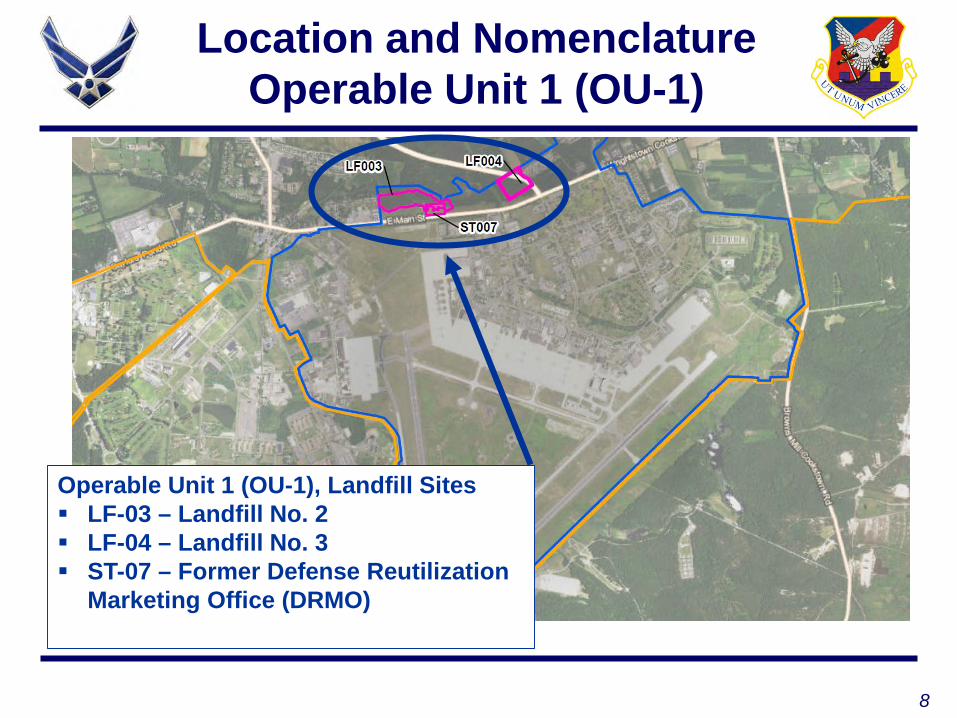
Location and NomenclatureOperable Unit 1 (OU-1)
Operable Unit 1 (OU-1), Landfill Sites LF-03 – Landfill No. 2 LF-04 – Landfill No. 3 ST-07 – Former Defense Reutilization
Marketing Office (DRMO)

9
OU-1 Site History(LF-03,ST-07, and LF-04)
LF-03/ST-07• Operated from 1950 - 1960s• Trench and fill• Mixed municipal waste• Generally a continuous waste mass• ST007: PCB removal action conducted during 2011
LF-04• Operated for a shorter duration 1956/57• 8 discrete waste burial pits

10
OU-1 Recent Investigations
LF-03• Baseline Ecological Risk Assessment • Surface water sampling and culvert investigation• Installation of a new monitoring well• “Pinelands” groundwater sampling• Slope stability analysis and landfill cover assessment
LF-04• Baseline Ecological Risk Assessment• Surface water sampling• “Pinelands” groundwater sampling

11
OU-1 Current Site Conditions
LF-03• Generally flat with the exception of the North Run
Embankment • Mixed open fields with heavy vegetation• North Run embankment• Groundwater flows to the North Run
LF-04• Gently sloping topography and heavily forested• Bisected by Defense Access Highway• Groundwater flows to the North Run

12
OU1 – Site Layout(LF-03/ST-07)
LF-03
ST-07
Groundwater Flow
13
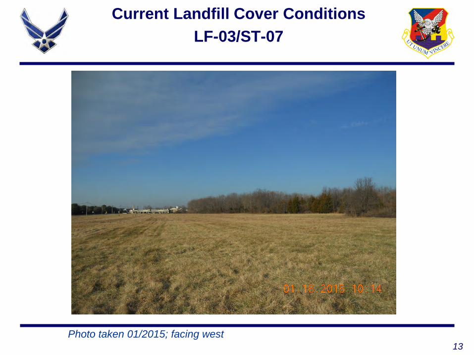
Current Landfill Cover ConditionsLF-03/ST-07
Photo taken 01/2015; facing west

14
Current Landfill Cover ConditionsNorth Run Embankment
Photo taken 01/2015; facing north toward North Run
15
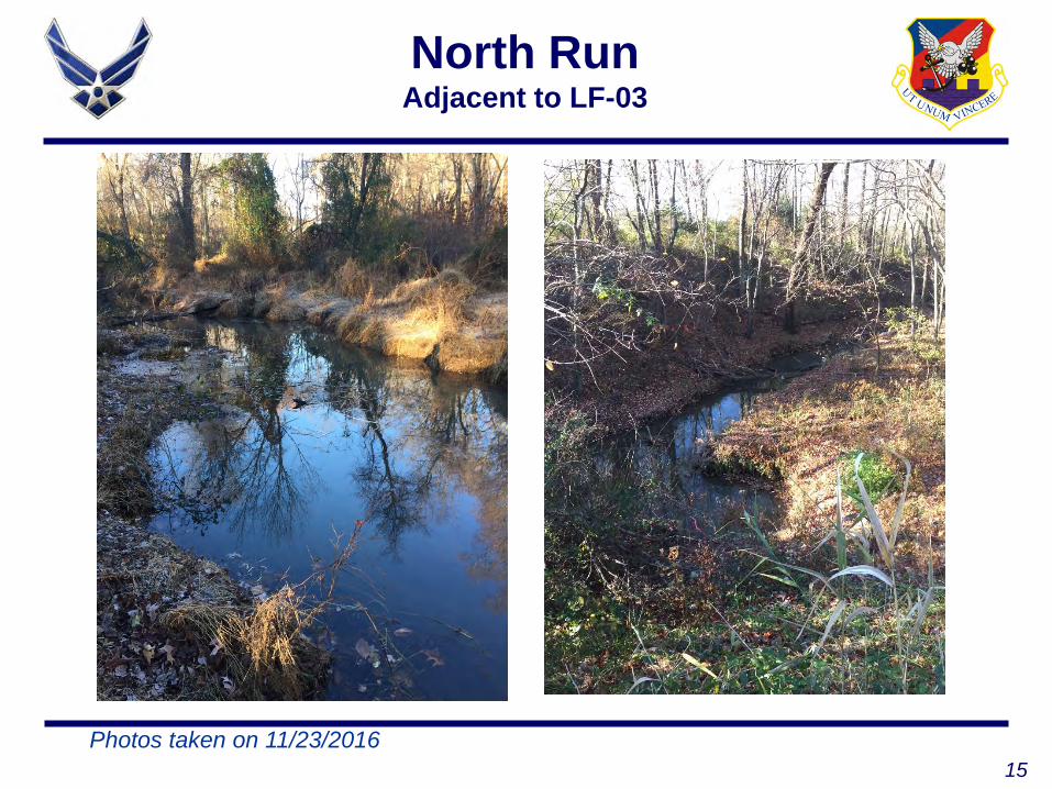
North RunAdjacent to LF-03
Photos taken on 11/23/2016
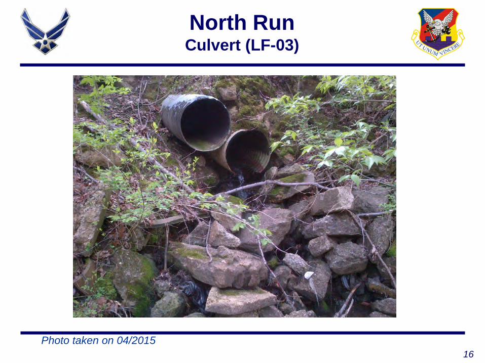
16
North RunCulvert (LF-03)
Photo taken on 04/2015

17
OU-1 – Site Layout(LF-04)

18
Landfill Cover ConditionLF-04
Photo taken on 04/2015
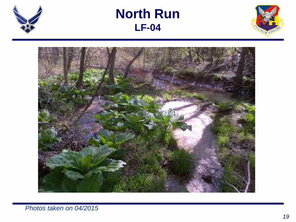
19
North RunLF-04
Photos taken on 04/2015

20
Surface Water Sample Results
Screening Criteria• Pineland non-degradation standards (e.g., Practical
Quantitiation Limit (PQL) and Background Threshold Values (BTVs)
• Health Based Standards (e.g., NJDEP Fresh Water Acute Toxicity and EPA MCL [Drinking Water Standard])
Metals• Excludes nutrient metals (e.g., potassium, calcium,
magnesium, sodium) • Higher of the BTV or PQL
BTV: Background Threshold ValuePQL: Practical Quantitation Limit
MCL: Maximum Contaminant Limit

21
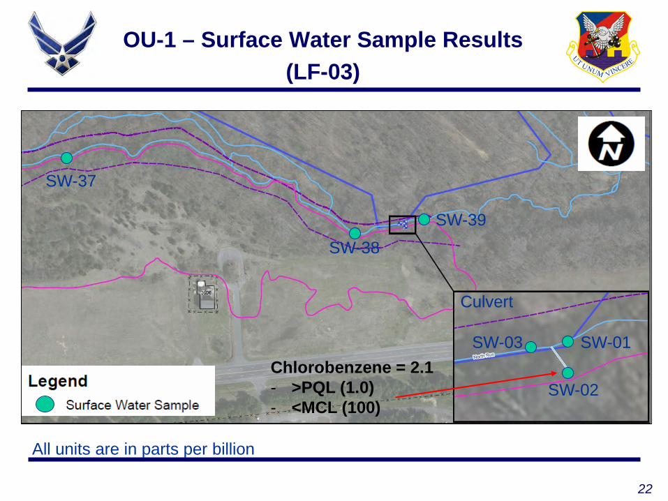
OU-1 – Surface Water Sample Results(LF-03)
SW-37- Toluene = 1.8
- >PQL (1.0)- <MCL (1,000)
- Pyrene = 0.54; >PQL (0.1)- Arsenic = 3.3; >PQL (3.0), <MCL (10)- Iron = 45,000; >BTV(4,990)
SW-38SW-39
SW-01
SW-02
SW-03
Culvert
All units are in parts per billion
22
OU-1 – Surface Water Sample Results(LF-03)
SW-37
SW-38SW-39
SW-01
SW-02
SW-03
Culvert
Chlorobenzene = 2.1- >PQL (1.0)- <MCL (100)
All units are in parts per billion

23
OU-1 – Surface Water Sample Results(LF-04)
SW-05SW-06
Bis(2-Ethylhexyl)phthalate = 8.7- >PQL (3.0)- >MCL(6.0)
All units are in parts per billion

24
OU-1 Focused Feasibility Study (FFS) Summary and Alternative Development

25
OU-1Use of a Presumptive Remedy
Question: What is a presumptive remedy?Answer: Preferred technologies for common categories of sites (e.g., landfills)
Presumptive remedies streamline the remedy selection process (i.e., removal not considered as an option)
Evaluates technologies that are best suited for the site Ensures consistent selection of remedial actions Landfill sites must exhibit “appropriate”
characteristics for applicability of a presumptive remedy (e.g., type of waste, volume, low risks/hazards)
26
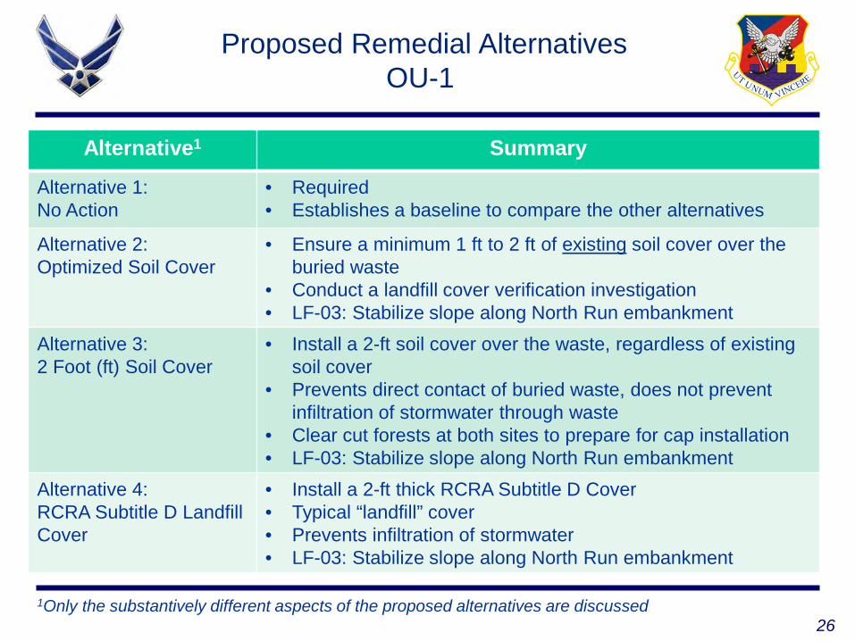
Alternative1 Summary
Alternative 1: No Action
• Required• Establishes a baseline to compare the other alternatives
Alternative 2: Optimized Soil Cover
• Ensure a minimum 1 ft to 2 ft of existing soil cover over the buried waste
• Conduct a landfill cover verification investigation• LF-03: Stabilize slope along North Run embankment
Alternative 3:2 Foot (ft) Soil Cover
• Install a 2-ft soil cover over the waste, regardless of existing soil cover
• Prevents direct contact of buried waste, does not prevent infiltration of stormwater through waste
• Clear cut forests at both sites to prepare for cap installation• LF-03: Stabilize slope along North Run embankment
Alternative 4:RCRA Subtitle D Landfill Cover
• Install a 2-ft thick RCRA Subtitle D Cover• Typical “landfill” cover• Prevents infiltration of stormwater• LF-03: Stabilize slope along North Run embankment
1Only the substantively different aspects of the proposed alternatives are discussed
Proposed Remedial AlternativesOU-1
27
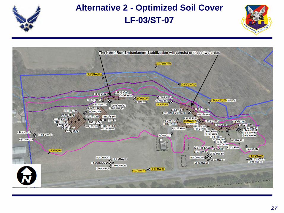
Alternative 2 - Optimized Soil CoverLF-03/ST-07

28
Subgrade Plan for Alternatives 3 and 4 LF-03/ST-07

29
Final Grading Plan for Alternatives 3 and 4LF-03/ST-07
30
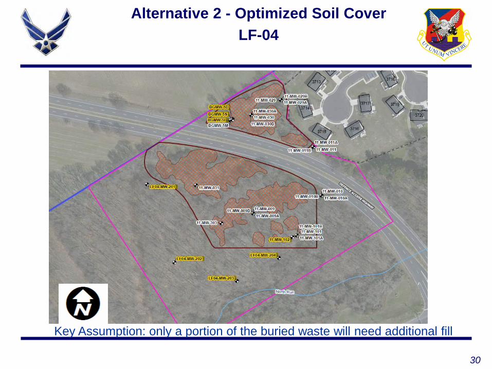
Alternative 2 - Optimized Soil CoverLF-04
Key Assumption: only a portion of the buried waste will need additional fill

31
Subgrade Plan for Alternatives 3 and 4LF-04

32
Final Grading Plan for Alternatives 3 and 4LF-04

33
OU-1 Path Forward
Date Activity
Nov 18, 2016 Internal Draft FFS submitted to JB MDL
Jan 2017 Draft FFS submitted for regulatory review
April 2017 Finalize FFS
Aug 2017 Finalize Proposed Plan
Feb 2018 Finalize Record of Decision
34
Operable Unit 3 (OU-3) Discussion

35
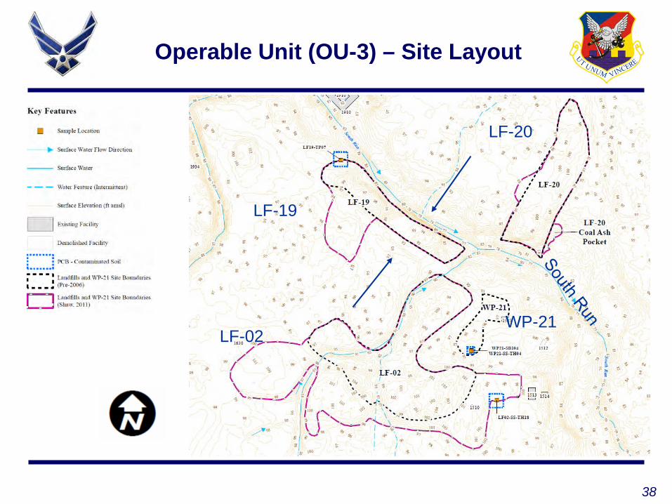
Location and NomenclatureOperable Unit 3 (OU-3)
Operable Unit 3, Landfill Sites LF-02 – Landfill No. 4 LF-19 – Landfill No. 5 LF-20 – Landfill No. 6 WP-21 – Former Waste Water
Treatment Plant Disposal Area
36
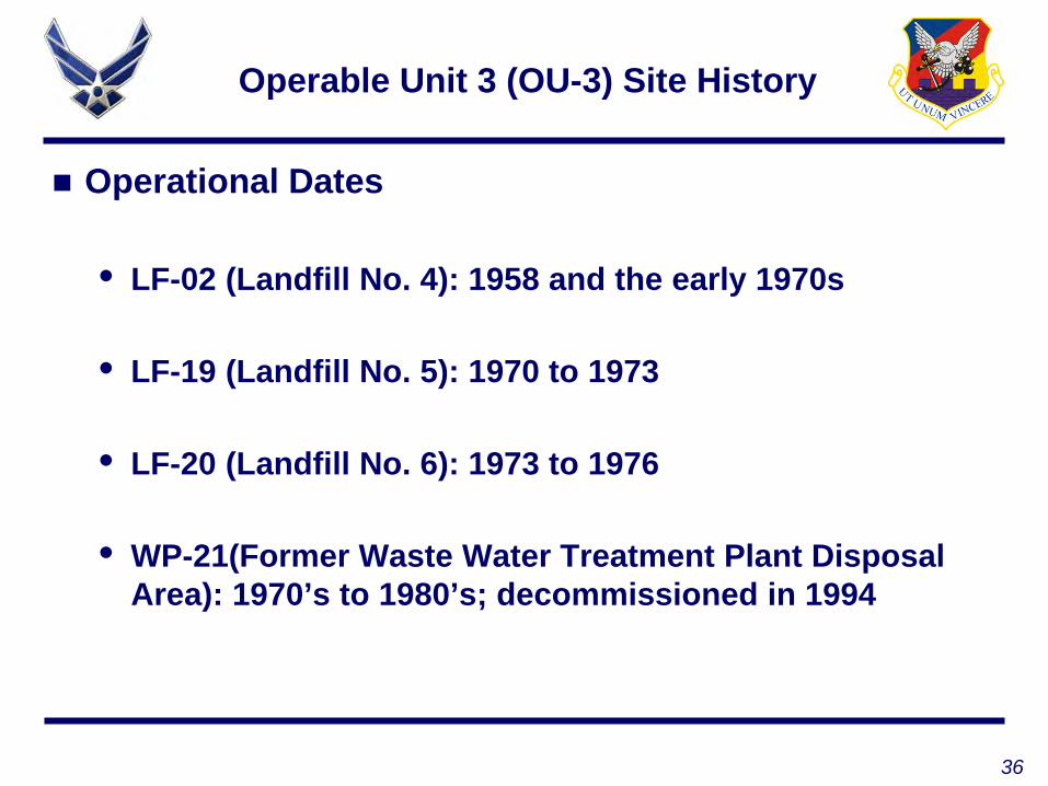
Operable Unit 3 (OU-3) Site History
Operational Dates
• LF-02 (Landfill No. 4): 1958 and the early 1970s
• LF-19 (Landfill No. 5): 1970 to 1973
• LF-20 (Landfill No. 6): 1973 to 1976
• WP-21(Former Waste Water Treatment Plant Disposal Area): 1970’s to 1980’s; decommissioned in 1994

37
Operable Unit 3(OU-3) Recent Investigations
Additional 11 monitoring wells installed during 2012
“Pinelands” groundwater sampling – two rounds during 2016
Annual landfill inspections conducted for 2015 and 2016
38
Operable Unit (OU-3) – Site Layout
LF-19
LF-20
LF-02WP-21

39
Current Landfill Cover Conditions
LF-02: Photo taken 11/2016; facing southeast
LF-19: Photo taken 11/2016; facing southeast
40
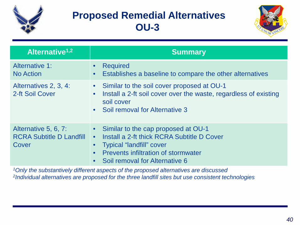
Alternative1,2 Summary
Alternative 1: No Action
• Required• Establishes a baseline to compare the other alternatives
Alternatives 2, 3, 4:2-ft Soil Cover
• Similar to the soil cover proposed at OU-1• Install a 2-ft soil cover over the waste, regardless of existing
soil cover• Soil removal for Alternative 3
Alternative 5, 6, 7:RCRA Subtitle D Landfill Cover
• Similar to the cap proposed at OU-1• Install a 2-ft thick RCRA Subtitle D Cover• Typical “landfill” cover• Prevents infiltration of stormwater• Soil removal for Alternative 6
1Only the substantively different aspects of the proposed alternatives are discussed2Individual alternatives are proposed for the three landfill sites but use consistent technologies
Proposed Remedial AlternativesOU-3
41
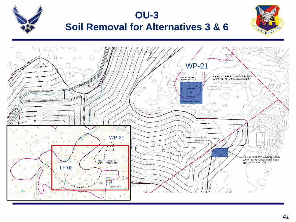
OU-3Soil Removal for Alternatives 3 & 6
LF-02
WP-21
WP-21

42
OU-3 Surface Water Sample Locations
LF-19
LF-20
LF-02WP-21
SW-A
SW-B
SW-C
43
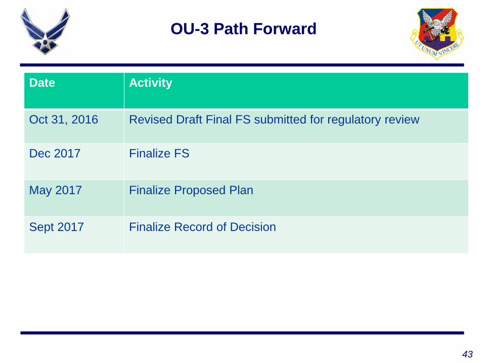
OU-3 Path Forward
Date Activity
Oct 31, 2016 Revised Draft Final FS submitted for regulatory review
Dec 2017 Finalize FS
May 2017 Finalize Proposed Plan
Sept 2017 Finalize Record of Decision

44
Questions?

87th Air Base Wing
Mr. Tim Llewellyn, Project ManagerARCADIS
Review of BOMARC Surface Water Data

46“WIN AS ONE”
BOMARC Surface Water
OT016, WP005, and ST015 Surface Water Evaluation
This presentation has been prepared to address these questions posed during the August 2016 RAB meeting with respect to the sampling history and delineation efforts within the BOMARC study area
47“WIN AS ONE”
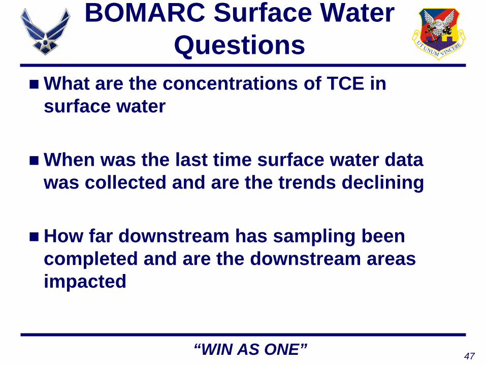
BOMARC Surface Water Questions
What are the concentrations of TCE in surface water
When was the last time surface water data was collected and are the trends declining
How far downstream has sampling been completed and are the downstream areas impacted

48“WIN AS ONE”
BOMARC Site Location
BOMARC SITE
49“WIN AS ONE”
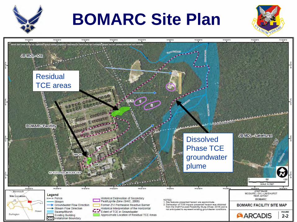
BOMARC Site Plan
Residual TCE areas
Dissolved Phase TCE groundwater plume
50“WIN AS ONE”
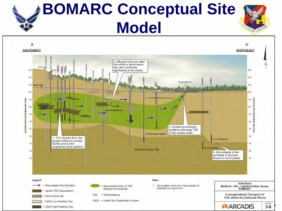
BOMARC Conceptual Site Model

51“WIN AS ONE”
Regional WatershedBOMARC SITE
Surface waters from BOMARC discharge to Success Branch generally moving north/northeast to Borders Mill Branch to Ridgeway Branch ultimately feeding into Union Branch and Toms River
General Flow Direction TCE Plume Discharge Area
52“WIN AS ONE”
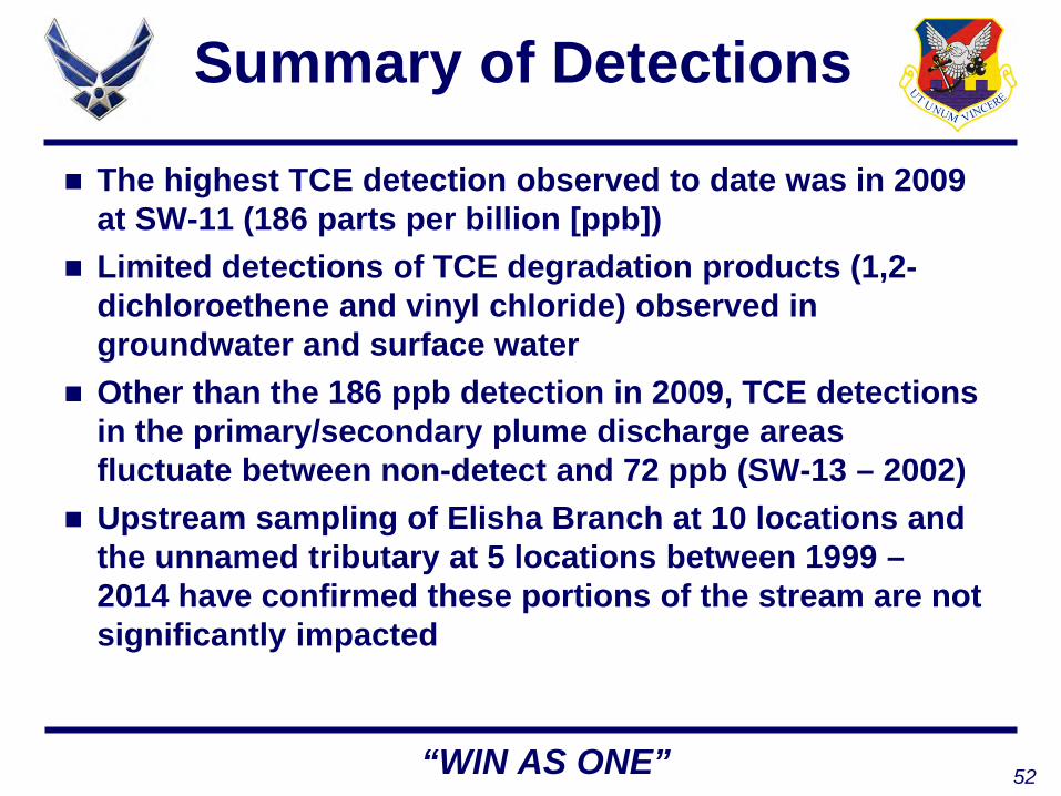
Summary of Detections
The highest TCE detection observed to date was in 2009 at SW-11 (186 parts per billion [ppb])
Limited detections of TCE degradation products (1,2-dichloroethene and vinyl chloride) observed in groundwater and surface water
Other than the 186 ppb detection in 2009, TCE detections in the primary/secondary plume discharge areas fluctuate between non-detect and 72 ppb (SW-13 – 2002)
Upstream sampling of Elisha Branch at 10 locations and the unnamed tributary at 5 locations between 1999 –2014 have confirmed these portions of the stream are not significantly impacted

53“WIN AS ONE”
Summary of Detections Continued
Sampling of Success Branch immediately downstream of the plume discharge areas conducted between 2001 and 2014 has confirmed TCE impacts
TCE concentrations continue to decline further downstream in Success Branch and Borders Mill Branch to the north/northeast and areas further away from the primary/secondary plume discharge areas but TCE is present
Overall, TCE detections observed between 1999 and 2014 show declining trends
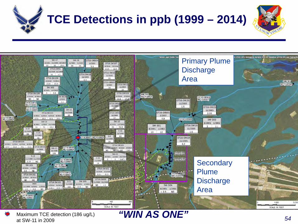
54“WIN AS ONE”Maximum TCE detection (186 ug/L) at SW-11 in 2009
TCE Detections in ppb (1999 – 2014)
Primary Plume Discharge Area
Secondary Plume Discharge Area
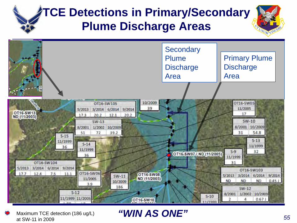
55“WIN AS ONE”Maximum TCE detection (186 ug/L) at SW-11 in 2009
TCE Detections in Primary/Secondary Plume Discharge Areas
Secondary Plume Discharge Area
Primary Plume Discharge Area

56“WIN AS ONE”
TCE Detections Upstream Areas
TCE detections at upstream locations along Elisha Branch were all below 1 ppb.

57
TCE Detections Downstream Areas
Further downstream (~1,500 feet) of TCE plume discharge areas (TCE ranged from non-detect to 12 ppb)
Immediately downstream of TCE plume discharge areas (TCE ranged from non-detect to 34 ppb)

58“WIN AS ONE”
TCE Trend at SW104 (primary plume discharge area)
0
10
20
30
40
50
60
7/6/2009 1/22/2010 8/10/2010 2/26/2011 9/14/2011 4/1/2012 10/18/2012 5/6/2013 11/22/2013 6/10/2014 12/27/2014
TCE
(ug/
L)
Date
OT16-SW104

59“WIN AS ONE”
TCE Trend at SW105 (primary plume discharge area)
0
10
20
30
40
50
60
70
4/19/2001 1/14/2004 10/10/2006 7/6/2009 4/1/2012 12/27/2014 9/22/2017
TCE
(ug/
L)
Date
OT16-SW105

60“WIN AS ONE”
Surface Water TCE Screening Criteria
Using the latest TCE toxicology values from USEPA Guidance published in 2014 the calculated risk-based level for a recreational exposure scenario to surface water is 38.3 ppb
Of the 61 locations samples between 1999 and 2009, 4 locations have exhibited TCE concentrations in exceedance of the recreational risk-based level
All 4 locations with TCE detections above the risk-based level are located within or directly downstream of the plume discharge area and limited to Success Branch
TCE has not been detected above the calculated risk-based level (38.3 ppb) since October 2009

61
Questions?
87th Air Base Wing
Mr. Tim Llewellyn, Project ManagerARCADIS
JB MDL PBR CONTRACT UPDATE

63“WIN AS ONE”
McGuire Summary
NPL Site StatusOU# Description Final FS Final PP Final ROD
OU1 3 Landfill Sites Under AF review Summer 2017 Winter 2018
OU2 10 Industrial Sites Summer 2017 Winter 2018 Summer 2018
OU3 4 Landfill Sites Under EPA/NJDEP review Spring 2017 Fall 2017
OU4 1 Jet Fuel Storage site Summer 2017 Winter 2017 Summer 2018
OU5 3 Misc. Sites Fall 2017 Winter 2018 Summer 2018
OU6 Fuel Spills under Apron Fall 2017 Winter 2018 Fall 2018
OU7 4 Industrial Sites Fall 2017 Winter 2018 Fall 2018
OU8 5 Sites on the Airfield Fall 2017 Winter 2018 Fall 2018

64“WIN AS ONE”
McGuire SummarySecond major groundwater sampling event completed in November
Total of 10 weeks in the field with 3 crews sampling a total of approximately 600 wells The new data was required to fully evaluate
compliance with the Pineland Standards Data will be used for remedy evaluation in the FS
documents Data evaluation now in progress and NPL
documents moving forward

65“WIN AS ONE”
McGuire Summary NPL Sites (Continued)
Pilot scale tests of potential remedies are complete at several sites Multiphase extraction at OU2 (solvents) Natural Source Zone Depletion at OU4
(jet fuel) Phase I: In-Situ Microcosms/enhanced
bioremediation at OU7 and OU8 (dissolved phase solvents)
66
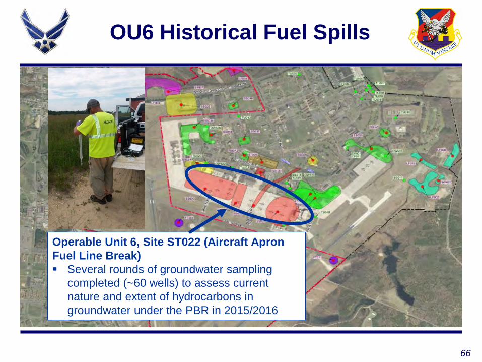
OU6 Historical Fuel Spills
Operable Unit 6, Site ST022 (Aircraft Apron Fuel Line Break) Several rounds of groundwater sampling
completed (~60 wells) to assess current nature and extent of hydrocarbons in groundwater under the PBR in 2015/2016
67“WIN AS ONE”
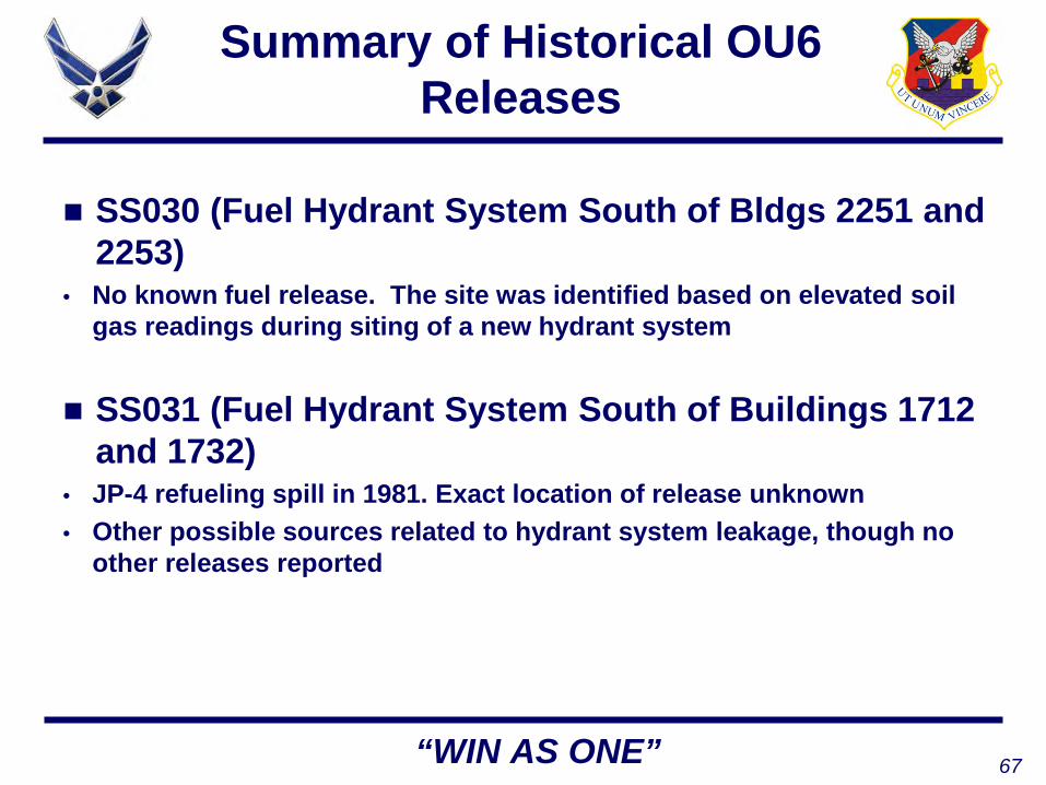
Summary of Historical OU6 Releases
SS030 (Fuel Hydrant System South of Bldgs 2251 and 2253)
• No known fuel release. The site was identified based on elevated soil gas readings during siting of a new hydrant system
SS031 (Fuel Hydrant System South of Buildings 1712 and 1732)
• JP-4 refueling spill in 1981. Exact location of release unknown• Other possible sources related to hydrant system leakage, though no
other releases reported
68“WIN AS ONE”
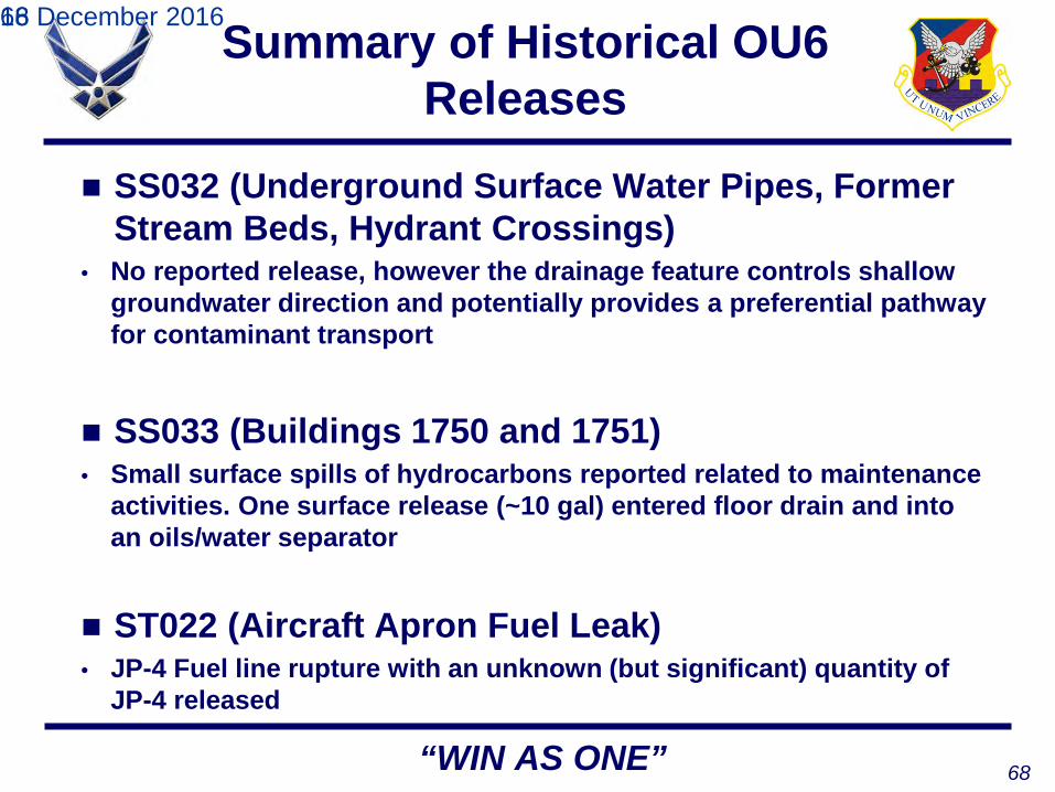
Summary of Historical OU6 Releases
16 December 201668
SS032 (Underground Surface Water Pipes, Former Stream Beds, Hydrant Crossings)
• No reported release, however the drainage feature controls shallow groundwater direction and potentially provides a preferential pathway for contaminant transport
SS033 (Buildings 1750 and 1751)• Small surface spills of hydrocarbons reported related to maintenance
activities. One surface release (~10 gal) entered floor drain and into an oils/water separator
ST022 (Aircraft Apron Fuel Leak)• JP-4 Fuel line rupture with an unknown (but significant) quantity of
JP-4 released

69“WIN AS ONE”
Location of Groundwater Plumes
ST-22JP-4 Release
1988
SS-30 Elevated Soil
Gas 1995
SS-31No release reported but coincident
with hydrant system pipeline
SS-31Possible location of
refueling spill
SS-33Supply warehouse and
maintenance/repair; small spills
70“WIN AS ONE”
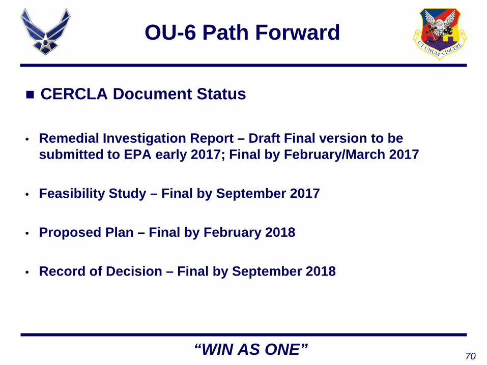
OU-6 Path Forward
CERCLA Document Status
• Remedial Investigation Report – Draft Final version to be submitted to EPA early 2017; Final by February/March 2017
• Feasibility Study – Final by September 2017
• Proposed Plan – Final by February 2018
• Record of Decision – Final by September 2018
71
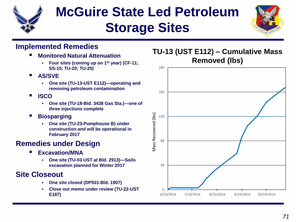
McGuire State Led Petroleum Storage Sites
Implemented Remedies Monitored Natural Attenuation
Four sites (coming up on 1st year) (CF-11; SS-15; TU-20; TU-25)
AS/SVE One site (TU-13-UST E112)—operating and
removing petroleum contamination ISCO
One site (TU-18-Bld. 3438 Gas Sta.)—one of three injections complete
Biosparging One site (TU-23-Pumphouse B) under
construction and will be operational in February 2017
Remedies under Design Excavation/MNA
One site (TU-03 UST at Bld. 2913)—Soils excavation planned for Winter 2017
Site Closeout One site closed (DP501-Bld. 1907) Close out memo under review (TU-22-UST
E187)
TU-13 (UST E112) – Cumulative Mass Removed (lbs)
0
40
80
120
160
200
6/19/2016 7/19/2016 8/19/2016 9/19/2016 10/19/2016
Mas
s Rec
over
ed (l
bs)

72“WIN AS ONE”
BOMARC Update Feasibility Study under NJDEP review OT-16 (Missile Launcher),
WP-05 (JP-X Discharge Pit), and ST-15 (MOGAS UST)
BOMARC SITE
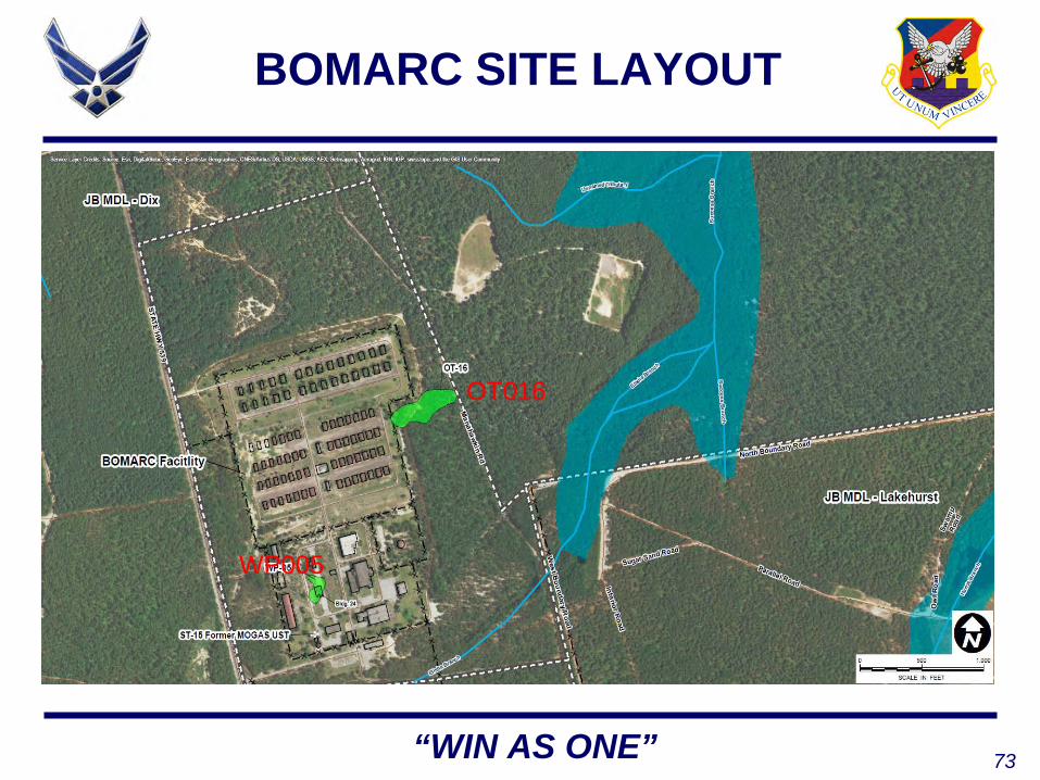
73“WIN AS ONE”
BOMARC SITE LAYOUT
OT016
WP005
74“WIN AS ONE”
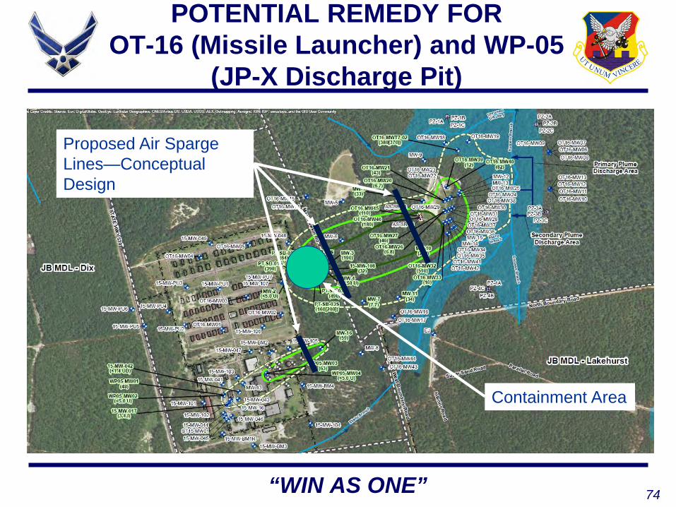
POTENTIAL REMEDY FOR OT-16 (Missile Launcher) and WP-05
(JP-X Discharge Pit)
Proposed Air Sparge Lines—Conceptual Design
Containment Area

75“WIN AS ONE”
BOMARC OT-16/WP-05 SCHEDULE
Feasibility Study Draft FS to NJDEP September 2016 (delayed from May to enable discussions
ahead of submittal) Final FS Winter 2016/2017
Proposed Plan Draft to NJDEP February 2017 Final PP (and public meeting) June 2017
Record of Decision Draft to NJDEP September 2017 Final ROD January 2018
Remedial Action Winter 2018

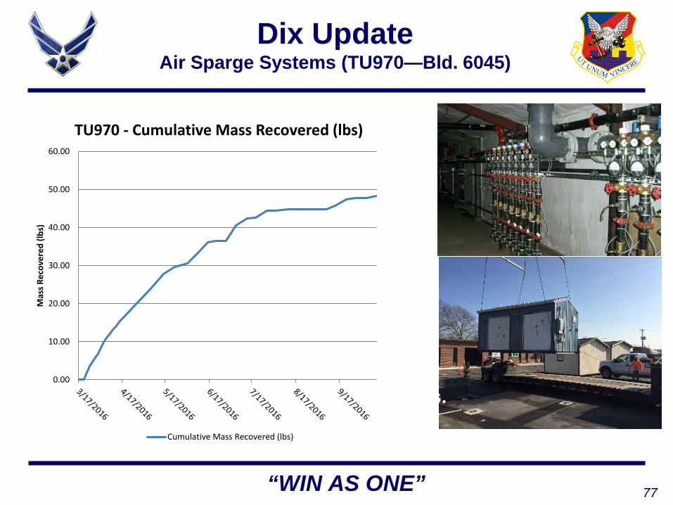
76“WIN AS ONE”
Dix Update Air Sparge Systems (TU-19a—Former Taxi Stand)
AS/SVE systems operational at all three sites.
0.00
50.00
100.00
150.00
200.00
250.00
Mas
s Rec
over
ed (l
bs)
TU-19a - Cumulative Mass Recovered (lbs)
Cumulative Mass Recovered (lbs)
77“WIN AS ONE”
Dix Update Air Sparge Systems (TU970—Bld. 6045)
AS/SVE systems operational at all three sites. 0.00
10.00
20.00
30.00
40.00
50.00
60.00
Mas
s Rec
over
ed (l
bs)
TU970 - Cumulative Mass Recovered (lbs)
Cumulative Mass Recovered (lbs)

78“WIN AS ONE”
Dix Update Air Sparge Systems (NW-44—Bld. 5136)
AS/SVE systems operational at all three sites. 0.00
20.00
40.00
60.00
80.00
100.00
120.00
140.00
160.00
Mas
s Rec
over
ed (l
bs)
NW-44 - Cumulative Mass Recovered (lbs)
Cumulative Mass Recovered (lbs)

79“WIN AS ONE”
Lakehurst Update
Areas A/B and C Semi-Annual sampling completed in
October 2016 Active remedies being designed for
4 sites to meet GW standards by 2021. Draft designs nearly completed for 3 of the 4 sites.
Pre-Design investigations complete at all 4 sites
Pilot Studies complete at 3 of 4 sites MNA remedies approved from 2
sites to meet GW standards by 2021Area D Annual GW sampling completed in
November 2016

80“WIN AS ONE”
Lakehurst Update
Area H Active pump and treat system
continues to operate Semi-Annual sampling
completed in October 2016
Areas I/J and K Annual GW sampling
completed in November 2016

81“WIN AS ONE”
Lakehurst Update
Soil collected during Area C Site AT016 Pre-Design Investigation Work
Groundwater Sampling to Support Design Investigations at Area C
82
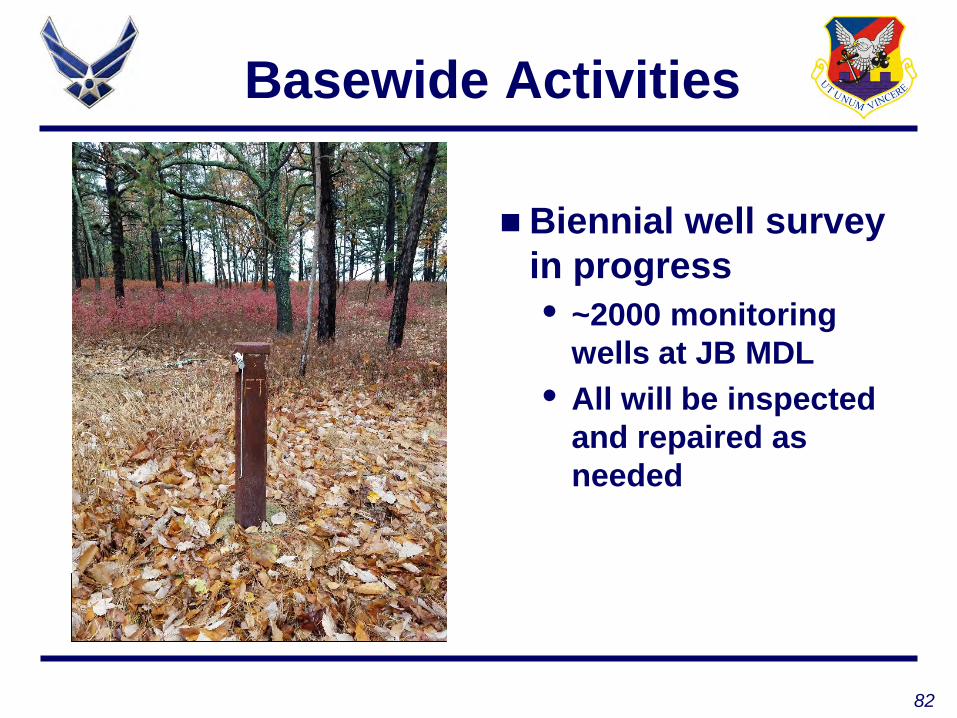
Basewide Activities
Base-wide Well Inspection Ongoing (Well FT at Area D)
Biennial well survey in progress• ~2000 monitoring
wells at JB MDL• All will be inspected
and repaired as needed

83
Questions?

84
RAB Agenda Ideas
“WIN AS ONE”
Tentative RAB date: 2017 schedule is to be determined Suggested agenda topics

85
PUBLIC COMMENTS


