POLICY OSL2 Conservation, Enhancement and Creation of Local Green Spaces and Other Parks and Green Spaces to Accommodate Growth No development will be permitted within the local green spaces listed in Policy OSL1 and shown on the local green spaces proposals map if it would impair the effectiveness of the site in serving one or more of the following purposes: a) Providing a resource for formal and informal recreation and/or a venue for formal events; b) Forming a green foreground or background which is important to the character of Liskeard’s setting; c) Helping to preserve the cherished views of the town centre, or of individual buildings or groups of buildings, or of the surrounding rural and heritage landscapes both into and out of the town; d) Providing areas of rural tranquility which surround or penetrate the built-up area of Liskeard and helps to maintain the relationship between the town and surrounding countryside; e) Contributing to the character and visual setting of the town by their open nature f) Conserving and enhancing biodiversity, ecological assets, ancient woodland, priority habitat deciduous woodland, watercourses and other landscape features important to the local community POLICY OSL3 Play Provision in Neighbourhood Areas The Neighbourhood Plan supports the provision of neighbourhood equipped areas for play (NEAPS) at Castle Park, Thorn Park and Rapsons Park, and of ‘natural play facilities’ at Sungirt Woods, Lanchard Woods and ‘Roundbury Park’. New housing or mixed use developments shall provide equipped formal and natural play in accordance with tables shown or provide contributions towards facilities as set out in order to provide each of the five neighbourhoods (see diagram pg 67) in the town with a range of equipped and natural play across all age ranges. NEAPS are also required within the urban extensions to be provided at Addington, Tencreek and Charter Way. 65
Transcript
POLICY OSL2Conservation, Enhancement andCreation of Local Green Spaces andOther Parks and Green Spaces toAccommodate Growth
No development will be permitted within thelocal green spaces listed in Policy OSL1 andshown on the local green spaces proposals mapif it would impair the effectiveness of the site inserving one or more of the following purposes: a) Providing a resource for formal and informal recreation and/or a venue for formal events; b) Forming a green foreground or background which is important to the character of Liskeard’s setting; c) Helping to preserve the cherished views of the town centre, or of individual buildings or groups of buildings, or of the surrounding rural and heritage landscapes both into and out of the town; d) Providing areas of rural tranquility which surround or penetrate the built-up area of Liskeard and helps to maintain the relationship between the town and surrounding countryside; e) Contributing to the character and visual setting of the town by their open nature f) Conserving and enhancing biodiversity, ecological assets, ancient woodland, priority habitat deciduous woodland, watercourses and other landscape features important to the local community
POLICY OSL3Play Provision in NeighbourhoodAreasThe Neighbourhood Plan supports theprovision of neighbourhood equipped areasfor play (NEAPS) at Castle Park, Thorn Park and Rapsons Park, and of ‘natural play facilities’ at Sungirt Woods, Lanchard Woods and ‘Roundbury Park’.
New housing or mixed use developments shallprovide equipped formal and natural play inaccordance with tables shown or providecontributions towards facilities as set out inorder to provide each of the fiveneighbourhoods (see diagram pg 67) in thetown with a range of equipped and naturalplay across all age ranges.
NEAPS are also required within the urbanextensions to be provided at Addington,Tencreek and Charter Way.
65
Application StandardConnection, design and management Open space scheme shall incorporate areas of existing on site and off
site landscape features such as mature woodlands, copses individual trees, wildflower meadows and hedgerows, watercourses etc and include appropriate new planting. Design should allow for good natural surveillance and overlooking, with lighting in appropriate circumstances such as a key route to school or workplace. A mechanism for long-term management of the developing landscape shall be submitted.
Open space development that encourages and contributes to improving the interconnectedness of green spaces, green corridors, significant woodlands, vegetation areas and road verges and tree-planted streets, will be encouraged.
Housing development open spaces Open spaces should be provided within or adjoining new housing development including housing specifically built for the elderly, in addition to the play space requirement. Open spaces should ideally be created around existing landscape features on the site and connect to landscape and green infrastructure off site. They should allow for additional landscaping as appropriate.
Non- housing developments In addition to the standards detailed above, informal open space provision will be encouraged as part of business park, retail and large-scale commercial developments; this is for the benefit and well being ofthe workforce and also visitors to the site. Any spaces provided should have regard to the nature and location of the development.
Exclusions from open space Open space must be usable for recreation unless set aside for biodiversity reserve. In Open Space Working Group Report, Appendix E lists the types of green and open space that shall not be used to fulfil the open space standard obligations.
LOCAL OPEN SPACE STANDARDS
66
Reasoned JustificationPolicy OSL1 - These areas are of particularimportance to the local community and fulfil therequirements of the NPPF for Local Green Spacedesignation in that each green space: a) Is in reasonably close proximity to the community it serves; b) Is demonstrably special to a local community and holds a particular local significance, for example because of its beauty, historic significance, recreational value (including as a playing field), tranquility or richness of its wildlife; c) and concerned is local in character and is not an extensive tract of land. A full up to date robust assessment of open spaces inLiskeard was carried out in 2015 using the Green Flagassessment procedure (available herehttp://bit.ly/2nwg7sk).
Policy OSL2 - The Neighbourhood Plan Open Spacesand Leisure Working Group audited (through site visits)44 open spaces within Liskeard town area (i.e. withinthe limits of the built up area, there being no publicaccessible spaces except public rights of way, outsidethe town limits), using the Green Flag Award4 qualitysystem as a basis for the appraisal. It revealed only 22ha of publicly accessible open space. This publicaccessible amount of open space is below the levelrecommended by the Cornwall Council Open Spacestrategy which requires 43 sq m/person. It is thereforeessential that existing green spaces be protected.
The Liskeard Town Council Open Space Audit of 2014recognized the potential role of the town’s attractiveand popular green hinterland and the link to the WorldHeritage Site at Caradon, and in January 2014 the
Town Council adopted the policy: “to protect andenhance the character and accessibility of the naturalgreen spaces around the boundary of the town,accessed via green corridors and quiet lanes, whichwould also fulfil the objective of the Cornwall LocalPlan to maintain the physical link between Liskeardand the world mining heritage site at Minions”.
Policy OSL3 - Equipped play provision in the townshould reflect neighbourhood accessibility andprovision across age groups. However, it is currentlyinadequate. Rapson’s park provides basic youngteenage play and skate ramp but needs additionalinvestment to improve natural surveillance, safe access(currently through a car park) and landscape design.The children’s play area at Castle Park needssignificant improvement. Carnclaze Close, Treveccaand Thorn Park are well equipped though require morefamily seating and better disabled access. A new playarea is planned in the new Addington development.There are other local Areas for Play around the townfor doorstep use by toddlers but cannot to beconsidered strategic play areas. It is also desirable toprovide areas for natural play that allow children to createdens and mazes, construct willow domes and arches, digmud pits or create steeping stone or balance log paths.Making accessible and managed woodland spaces in thetown such as at Sungirt, Lanchard and CatchfrenchCrescent woods could provide more play at reasonablecost. A rural edge of town play area with good parkingaccess would be highly valued by families.
Comment Where appropriate, investment throughplanning obligations related to developments whichbring additional population to Liskeard will be directedtowards the maintenance, conservation andenhancement of the key existing public parks atWestbourne Gardens, Castle Park, Thorn Park andRapsons Open Space, and improved access andfacilities at natural spaces Catchfrench CrescentWoods, Sungirt Woods and Lanchard Woods. The intention will be to bring greater diversity and lowermaintenance costs, for example by utilizing gravelpaths, mowing regimes and natural planting with low-cost native plants, provision of simple timber or granitesseats, localised community planting/gardens etc toprovide more varied, accessible and interesting facilities.
Where appropriate, investment through planningobligations related to developments which bringadditional population to Liskeard will be directedtowards the maintenance, conservation andenhancement of these facilities.
67
NEIGHBOURHOODS AROUND LISKEARD
POLICY OSL4 Locations for Enhanced Public RealmAccess and EnvironmentalImprovements Schemes to enhance the Public Realm for pedestriancomfort, improved convenience of access andconnectivity, including improved access for mobilityimpaired users through improved surfaces, levelchanges, handrails etc, quality signage, tree planting,cycle parking, public seating and trolley friendly surfaceswill be implemented. Contributions will be soughttowards works from development in the town as alldevelopment directly affects the town's public realm.The main focus will be on:
a) The Dean St/Barras St/Windsor Place junction with barrier free pedestrian-prioritised design linking in with the existing Dean St civic space b) Bay Tree Hill – in accordance with CLP retained policy (Lisk 5 - former Caradon Local Plan), with possible timed road closures. c) Liskeard Railway Station (including links between mainline and branch line stations) with disabled parking, kiss ‘n ride, rail staff parking and taxi rank to reduce conflicts and promote sense of place for arriving passengers. d) ‘Pedestrian and cycle links between the Station and the Town Centre.’ e) Conserve and enhance The Parade as civic space.
OBJECTIVE 2Enhance access within the town centre for pedestrians by: a) Use of shared surfaces e.g. (Dean St/Barras St/The Parade) b) Bay Tree Hill re-modelling - (Caradon saved policy) c) Liskeard Station gateway, enhancement of public realm, signage d) Improved pedestrian crossings, signage, street trees Promoting better access for disabled (TC Obj 4)
Projects I & J – Whilst Liskeard’s open spacesscore reasonably on maintenance and access(other than for disabled), they are poor in provisionof cultural heritage, interpretation and education, oradequate responsiveness to the needs of people interms of signage, seating, interest, or otherelements that would make them attractive. In anage of increasing obesity and mental healthproblems, this low quality indication suggests ouropen spaces are failing to provide basic levels ofservice that might contribute to reducing pressureon other services such as health and education.
PROJECT I (OSL)Parks and Open Space ManagementRefresh Set up a town-wide initiative and strategy withaction plan to support the positive and progressivemanagement of parks and green spaces aroundthe town based on simple objectives for openspace types and new partnerships. As part of thisstrategy, review how the local authorities can work
with community groups to utilise funding to createfacilities (podium, utilities etc) for ‘party in the park’events/live music in Westbourne Gardens, CastlePark and Sungirt Woods.
See also H (TC) Castle Park Improvement Scheme- to improve a valuable public and historic resource,providing improved leisure and historic resourceinterpretation to support the Town Centre
PROJECT J (OSL)Town Council Open Space Audit review Review the 2014 town council open space audit &policy 2014 to identify specific design andmanagement proposals for each park and greenspace, as listed in Policy OSL1. Set out a spatialstrategy, in partnership with other stakeholders, forthe enhancement of their relationship to the wider,landscape and heritage and ensuring accessconnections in this plan are accounted for. Include alandscape and heritage assessment study of the rural hinterland.
68
Reasoned Justification Land use planning has a key role in delivering theConnecting Cornwall Transport strategy. By shapingthe pattern of development and influencing thelocation, scale, density, design and mix of land uses,planning can help to reduce the need to travel,reduce the length of journeys and make it safer andeasier for people to access jobs, shopping, leisurefacilities and services by public transport, walking,and cycling. The way we design and use publicspaces also helps tackle climate change and healthand well-being.
Pedestrian use of Barras Street in Liskeard has beenshown by Cornwall Council to have consistentlyfallen year on year in the past decade whilst trafficlevels make it one of the busiest trafficked towncentre main streets in the county. The need is tocreate a better balance between traffic and othertown users, improve conditions for walking andcycling in the town, and improve the visual quality of
the streetscape. There are key focal areas within thepublic realm of Liskeard that have consistently beenmentioned in surveys as being of concern or causingdifficulty to users. These include the main junction atBarras St/Dean St/Windsor Place where barriers,footway levels and signage are all combining toprevent a good walking or visual environment; andBay Tree Hill which is a natural urban three sidedspace that is dominated by vehicles although couldhave far more pedestrian priority within it. Otherspaces, such as the area fronting the RailwayStation, could contribute more as an importantgateway to the town.
Comment Where appropriate, investment throughplanning obligations related to developments whichbring additional population and traffic to Liskeard willbe directed towards these improvements.
POLICY OSL5Open Space and DeveloperContributions Developers of housing sites (including affordable andstarter homes), larger holiday accommodation(hotels, caravan parks etc.) and developments thatimpact upon access to public open space will berequired to make financial contributions towards thecreation and maintenance of new and/or theextension and enhancement of existing public openspace facilities. The level of contribution for each sitewill be determined taking into account the table
below. On-site open space must be laid out prior tooccupation of 75% of dwellings in any phase, andoff-site contributions to be paid prior to occupationof 50% of dwellings.
Where on-site provision is required, the localplanning authority may seek the option of acommuted capital sum to construct the facility. Inthese circumstances, a serviced site (as appropriatefor the facility concerned) may be transferred to thetown council free of charge by the developer.
OBJECTIVE 3Encourage the creation of new green spaces (formal and informal) by: a) Applying conditions to planning approvals b) Providing new sports and multi-use park off St Cleer Rd at Roundbury c) Conserve existing and extend provision of orchards and allotments through developer contributions OBJECTIVE 4Encourage greater access to sports facilities by: a) Encourage multi-functional use of existing pitches/spaces and developer led provision of additional space (e.g. Roundbury)
69
Type Provision to meet Provision to Future quantity Minimum quantityexisting shortfall meet additional provision minimal needed for new
requirements from standard town-wide housing (m2/dwell)population growth (m2/person)
1 Parks and New ‘Roundbury Park’ proposal New ‘Roundbury Park’ 8.75 20.12Amenity (Policy OSL6 and former proposal
Caradon L.P. ALT15) (Policy OSL6)
Conserving & enhancing Conserving & enhancingour parks and green spaces our parks and green spacesto accommodate greater to accommodate greateruse (Policy OSL3) use (Policy OSL3)
Urban boundary planting at Tencreek and Charter Way
2 Natural New ‘Roundbury Park’ ‘Natural play facilities’ at 15.44 28.49Space proposal (Policy OSL6) Sungirt woods, Lanchard
Woods and Roundbury Park.(Policy OSL4)Urban boundary planting at Tencreek and Charter way
Buffer land adjoining employment land allocation, east of Charter Way(Policy EM1)
3 Public New ‘Roundbury Park’ New ‘Roundbury Park’ 15.3 - typ8 35.26sport proposal (Policy OSL6) proposal (Policy OSL6)
4 Children’s Neighbourhood Equipped Neighbourhood Equipped 0.7 1.61Equipped Play Areas for Play (NEAPS) at Areas for Play (NEAPS) at
Castle Park, Thorn Park Castle Park, Thorn Park and Rapsons Park and Rapsons Park(Policy OSL4) and allocated (Policy OSL4) and allocatedat Addington, Tencreek at Addington, Tencreek and Charter Way and Charter Way
5 Teen Neighbourhood Equipped Neighbourhood Equipped 0.25 0.58Provision Areas for Play (NEAPS) at Areas for Play (NEAPS) at
Castle Park, Thorn Park Castle Park, Thorn Park and Rapsons Park and Rapsons Park(Policy OSL4) and allocated (Policy OSL4) and allocated at Addington, Tencreek and at Addington, Tencreek andCharter Way Charter Way
6 Allotments New allotments and/or New allotments and/or 0.75 1.73community orchard at community orchard atBoveway Lane (Maudlin)/ Addington, Boveway Lane/Carthew Close, Charter Way (Maudlin)/Carthew Close,and Culverland Rd Charter Way, Woodgate Rd
and Culverland Rd areas
7 Cemeteries Adequate capacity in the 2.13 ~existing cemetery; future expansion space allocated on the adjacent (temporary) rugby practice pitch
8 School Pitches ~ ~ 15.3 - typ3 ~and clubs
TOTAL 43.36
TOTAL for 1-6 32.12 87.78
PROPOSED QUANTITY PROVISION STANDARDS FOR STRATEGIC OPEN SPACE IN LISKEARD
70
POLICY OSL6Meeting the Communities Need forSports and Leisure Approximately 8.8 hectares of land adjacent to StCleer Road and identified on the proposals map isallocated for open recreational use. Land use willcomprise playing fields, play areas, public openspace, and ancillary buildings such as changingrooms, cycle hire shop, café and shelters.
Where appropriate, investment through planningobligations related to developments which bringadditional population to Liskeard will be directedtowards the creation of this new park.
In addition, parkland and natural areas will beprovided in the mixed-use urban extensions to beprovided at Addington (3.08ha), Tencreek (4.1ha)and Charter Way (4.8ha), and as part of theemployment land allocation on land east of CharterWay (Policy EM1)
Reasoned JustificationPolicy OSL5 - The Neighbourhood Plan OpenSpaces Audit revealed only 22 ha of publiclyaccessible open space. This public accessibleamount of open space is below the level recommended by the Cornwall Council Open Spacestrategy (which requires 43 sq m/person). It istherefore essential that new open and green spacesare provided to meet community requirements.
The Audit also found many of Liskeard’s parks to belacking in cultural resonance, provision of facilities for allages such as places to sit and relax, imaginative plantingor natural habitats that encourage wildlife, although theywere generally well kept with grass cut and litter usually
collected. In order to meet the needs of the existingpopulation and those living in new developments, it isnecessary to invest in improving a few parks and naturalgreen spaces as the primary community spaces, inaddition to the provision of new facilities.
Policy OSL6 - There is also a shortage of playingpitches to meet current and forecast needs, requiringrugby and football clubs to use school pitches andlimiting their development. The allocation for playingfields of land at Roundbury, on the St Cleer Road willprovide playing pitches and running track as well asleisure facilities such as a cycling hub, play area, carparking and changing rooms/café, all in a naturallylandscaped park that should blend into the countryside.Consideration could also be given here to specialisedplay provision for disabled children.
Policy OSL7 - More innovative uses encouraged inappropriate locations will add to the attraction andversatility of green spaces, providing a betterexperience for users.
POLICY OSL7Provision of Orchards and Allotments Protect existing allotments at Pengover Road,Dungarth Road and extend provision of orchardsand allotments through developer contributions onor offsite at Maudlin Farm, Woodgate Road,Culverland Road, Charter Way, Tencreek andAddington
71
Comment For smaller developments (11 or moredwellings) within acceptable range of some form ofopen space (in accordance with adopted standards)contributions will be sought off site entirely via aSection 106 agreement or planning condition. Forlarger developments this will be a combination of on-site provision and some off-site. To help work throughthe requirements the Open Space Planning toolkit hasbeen prepared by Cornwall Council for use on alldevelopments.
Liskeard has a good supply of natural green spacesaround and within the town but their undesignatednature and lack of any positive management meansthey have lacked design, management or investmentto provide adequate walking and cycling to and fromthem and within and through them. The intention is toensure that these areas are clearly available for accessby residents of all types and ages, are safe andconvenient whilst recognizing their rural nature andavoiding the urbanizing of their features. Spacesshould have quality access and should be managedto maintain biodiversity and rural character. Theintention is also to prioritise those that have public
rights of way through them or that form natural routesto and from local facilities such as schools, shops etc.
‘Roundbury Park’ continues the allocation of land inthe former Caradon Local Plan saved policy ALT15.
PROJECT K (OSL)Roundbury Park development briefPrepare a development brief, design andprocurement strategy and outline management planfor Roundbury Park.
PROJECT L (OSL)Allotment and community orchard planEnhance community orchards and allotments atPengoverRoad, Trevecca Cottages, and DungarthRoad. Create community orchards and allotments atBoveway Lane (Maudlin Farm)/Carthew Close,Charter Way and Culverland Road. Identify sites for community orchards in the south(Lamellion) and west of the town.
OBJECTIVE 5Protect and enhance the character of the surrounding countryside by: a) Conserving and enhancing designated landscapes, heritage assets and areas of local significance, that are valued for their tranquility, views and contribution to health and well-being b) Promoting the use of low-impact lighting into our countryside in support of a dark skies objective (plus sustainable low-energy lighting within the town) c) Fulfilling and enhancing [Local Plan objectives] relating to the World Heritage Mining area d) Designate area of local landscape and heritage value as a precursor to extension of the local AGLV to provide stronger protection for heritage assets and valued landscape.
POLICY OSL8Routes and Settings of Caradon Trail,Liskeard Caradon Railway WorldHeritage Site and Looe Valley CycleTrail Development which would adversely impact on theroutes and settings of the designated Caradon Trail(green corridor) and proposed looe valley cycle trail,in terms of its location, functional connection,
appearance, heritage value and interpretation, andthe safety of pedestrian and cyclist users, will notbe permitted.
Development on or adjacent to the LiskeardCaradon railway line designated WHS will not bepermitted unless it conserves and enhances theasset, its setting and landscape context. Fullheritage impact assessment will be required for anydevelopment in the WHS buffer zone.
72
POLICY OSL9Dark Sky Designs which incorporate measures to reducelight pollution, into adjoining properties or theopen countryside will be supported. Proposalsmust include an assessment of the impact of lightpollution from the development on local amenity,surrounding countryside and dark landscapes, aswell as nature conservation, identifying mitigatingmeasures to be incorporated.
These could include: • The use of full cut off streetlights in rural edge highway and public space lighting • Restricted and careful use of flood and security lighting including effective baffling and motion sensors
• Low colour temperature lighting
• Landscaping to reduce glare and light throw, off site
73
Reasoned JustificationPolicy OSL8 – The landscape surrounding Liskeardhas escaped the plot and paddock landfragmentation often associated with the urban fringeand by-pass development, providing a setting whichis highly valued locally and through which pass theCaradon Trail and the proposed Looe Valley Trail,enabling re-connection with the landscape andheritage of the area. Developments which mightcause the blockage or relocation of these routes ortheir connections with the town, spoil theappearance of the routes, harm the heritage valueof features, and reduce the safety and convenienceof users, is undesirable.
The settings of World Heritage Sites are recognisedas making a fundamental contribution to theirOutstanding Universal Value and the agreedStatement of Outstanding Universal Value is anessential reference point when consideringdevelopment affecting the setting of a WorldHeritage Site. Cornwall & W Devon mininglandscape supplementary planning doc. (draft Feb.2016) states that “ policy frameworks at all levelsshould conserve the outstanding universal value,integrity & authenticity of each WHS and its setting,given that WHS are designated heritage assets ofthe highest significance.”
Policy OSL9 - National Planning Policy Framework(para 125) says that ‘by encouraging good design,planning policies and decisions should limit the
impact of light pollution from artificial light on localamenity, intrinsically dark landscapes and natureconservation’. Careful design can also contribute tothe proposed ‘Dark Sky Park’ initiative BodminMoor, the proposed buffer zone which enters theLiskeard Neighbourhood Development Plan area.
Policy OSL10 - to the west and north of the townlies the locally cherished landscape including theWorld Heritage Site Liskeard & Caradon railwaytrack-bed and Ladye Park/Old Park valley with itsmedieval landscape, associated Ducal deer park,and the historically significant Moorswater valley.These important landscapes are highly valuedlocally for their contribution to the character anddistinctiveness of Liskeard and should be retained,respected and enhanced. They are considered tobe of equal and in places superior quality to thealready designated Area of Great Landscape Valuenorth from Treworgey to St Cleer and also forms animportant part of the distinctive setting of Liskeard.
The Cornwall Local Plan describes Liskeard’s setting“on its hilltop, overlooking wide tranches oflandscape as an important characteristic” and Inrecognition and regard for our local designatedAGLV’s there is support in policy 22 for providing astrong statement on their extent and significance;“to inform and produce strong revised statements ofthese local designations of landscape value”.As part of the WHS initiative, the Caradon Hill AreaHeritage Project, supported by the Cornwall HistoricEnvironment Service, carried out a detailed study ofthe area from the North of Liskeard to the miningsite at Caradon Hill, which indicates that the wholearea is medieval in terms of field structure,landscape and farming settlements, including thesite of a large ducal deer park.
The above is reinforced by the Open Space WorkingGroups community engagement event, where theirstudy of the area was open to public consultationand received support as an area of local significance.
POLICY OSL10Area of Local Landscape and Heritage Value The area between the development limit and theCaradon AGLV, (CL8 & 9 saved policies), isdesignated as an area of local landscape andheritage value with a view to future redesignation asan extension to the area of great landscape value. Within this area, any development which ispermitted should recognize and respect thelandscape character, pattern and scale ofsettlement, and reflect the traditional building styles,materials and design of the local area. Proposals to create greater recreational linkages inthe form of permissive paths connecting to theexisting network of paths and bridleways, signageand interpretive material will be supported. .
74
75
National Planning Policy Framework says thatpolicies may “identify and protect areas of tranquilitywhich have remained relatively undisturbed by noiseand are prized for their recreational and amenityvalue for this reason” (NPPF para 123). This isreiterated in Cornwall Local Plan Policy 23 whichsays that “Development must take into account andrespect the sensitivity and capacity of the landscapeasset, considering cumulative impact and the wishto maintain dark skies and tranquility in areas thatare relatively undisturbed”.
Liskeard people see this area as a valuable localresource – it has quiet, Cornish lanes, abundance offlora and fauna and sweeping landscape views andas such is well-used and enjoyed by walkers,cyclists, horse riders, running groups, families withbuggies, dog walkers etc. thus contributing to thelocal communities 'health and well-being’ ( One ofNPPF core planning principles and CLP policy 17). It is traversed by the designated Caradon heritagetrail and proposed Looe Valley trail, forming a greencorridor that supports both recreation and natureconservation. This areas protection andenhancement could also provide economic benefitsto the town through its attractive setting andheritage assets, especially the World Heritage Siterailway track bed link.
CommentA ‘dark sky park’ is an area of land that isrecognised internationally as having an exceptionalquality of starry nights and a nocturnal environmentthat is protected for its scientific, natural,educational, cultural heritage, and/or publicenjoyment. As well as helping to protect the nightsky from light pollution, Dark Sky designationprovides a focus for awareness and learning aboutthe stars and solar systems, brings health and bio-diversity benefits, and provides an opportunity forlocal tourism. Within and on the boundaries of suchParks, steps to reduce light pollution, such asInstalling lights that point down not up, turning lightsoff when not needed, using automatic timers andonly lighting where necessary, are encouraged.Recent light readings show the quality of the nightsky over Bodmin Moor is amongst the best in theworld. The current proposal is for the core area tofollow the designated Bodmin Moor AONBboundary, with a 2 mile buffer area around this inwhich good lighting practice would be encouragedwith communities reaping some of the benefits. That
2 mile buffer includes the northern part of theLiskeard Neighbourhood Plan area.
POLICY OSL 11Cherished ViewsAny development proposals affecting the cherishedviews set out in this document must demonstratethe impact on the cherished view by providing ananalysis through an accurate visual representationalassessment and statement*. Such statements mustset out a description of the cherished view anddescribe the nature of the impact or harm to theview from the proposals, taking into account thecumulative impact on the view, caused by anyexisting unimplemented development proposals andidentify any mitigating measures to be incorporatedinto the development as necessary.
*These will normally be set out in the Design andAccess Statement or Environmental Statementaccompanying a planning application. Each shouldconsider the impact of the view taking into accountthe foreground, middle ground and backgroundimpacts.
Reasoned Justification The existence of particular and familiar views adds topeoples’ enjoyment of their locality, their sense ofplace and local distinctiveness, and even their senseof belonging to a particular place and community.Such views can become cherished because of thepresence of distinctive buildings in the townscapeand landscape, or because they frame the setting forpeople’s everyday existence within their communityand family life, having value as the place where theirlife experiences occur and giving a sense ofpermanence and continuity. They may underpin localdiversity and character, or project national identity ina locally relevant way. This ‘attachment to theordinary landscape’ has important implications forpsychological and thereby to social well-being, and isan essential element in sustainable development.
CommentThe ‘Open Space’ Working Group has examined thelandscape and townscape of Liskeard and throughits workshop meetings and consultation haveidentified cherished views for Liskeard.
OBJECTIVE 6Make provision for enhanced connectivity throughout the town and into the near countryside by:
a) Facilitating safe access for walkers, cyclists, horse- riders & others including crossings b) Designation of footpaths, bridleways, trails, quiet lanes and green corridors c) Protecting and enhancing designated trails (Caradon Trail) and supporting creation of new ones
(Round Liskeard Trail, Looe Valley Trail), as part of leisure and sustainable transport strategies
POLICY OSL12BProtection Of Pedestrian, EquestrianAnd Cycle Links And CorridorsDevelopment which would adversely impact on theroute and setting of the round Liskeard Trail and linksto Caradon and Looe Valley cycle trail, in terms of itslocation, functional connection, appearance, heritagevalue and interpretation, and the safety of pedestrianand cyclist users, will be not be permitted. Furtherprotect trail routes by seeking Quiet Lane status’
Reasoned JustificationLiskeard has a series of open spaces scattered in valleysand hilltops across the town, the linking of these areaswill form an important way of being able to enjoy thembetter as well as providing an important green networkthat will support biodiversity. The aim is to improve theselinks as comfortable walking and, where possible, cyclinglinks (see connectivity map). As well as the physicalability of local residents to access natural green space itis important to address how equal access to nature is fordifferent groups in the community. Emotionalconnectivity, whilst not a spatial plan issue, will beenhanced through better physical linkages. NPPF Para125 and policy 23 of Cornwall Local Plan, quoted earlier,are relevant here also.
Comment. These linkages may be main roads withspace for avenue tree planting and space for good cyclelanes, or at times they may be narrow lanes with lowtraffic volumes or alleys that have been built into housingestates. Importantly too there are a range of old greenlanes such as Sungirt Lane, Lanchard or Boveway Lanes,that have become part of the fabric of the town and actas regular public footpaths. Crossing points at busyroads need to be provided with traffic islands and dropkerbs, and planting improved and managed to enhancetheir amenity and natural habitats wherever possible.Opportunities to provide ‘fitness trails’ with exerciseequipment suitable for unsupervised use at appropriateintervals should be considered.
Where appropriate, investment through planningobligations related to developments which bringadditional population to Liskeard will be directedtowards new or improved pedestrian and cycle linksand corridors that form part of this network.
"Local amenities" are: shops and services, a primary [orsecondary] school with available places, healthcarefacilities, cultural, religious and recreational facilities,libraries, places of worship, cinemas, sports &community centres, evening classes, play parks andopen spaces, rail station, and regular bus-service stop.
POLICY OSL12APedestrian, Equestrian And Cycle LinksAnd Corridors When formulating S106 agreements associated withnew residential development, consideration shouldbe given to the inclusion of proposals that provideor support facilities that form part of the strategicpedestrian, equestrian and cycle network forLiskeard in order to:
a) Create new and improve existing walking, equestrian and cycling connections where routes are disjointed, enhance surfaces, and create safe priority road crossings and/or inline highway routes; b) Create new designated footpaths, bridleways and cycle paths to improve the movement network for these modes and enhance permeability; and c) Create direct and safe routes to local amenities d) Provide linkages or safe road crossings between parts of existing or proposed routes e) enhance the function and appearance of designated quiet lanes
76
PROJECT M (OSL)Walking, equestrian and cycling localinfrastructure plan for LiskeardPartner with Cornwall Council, Sustrans, RamblersAssociation, East Cornwall Riding Club (and otherrelevant bodies such as Living Streets, Walkers areWelcome, Cornwall Cycle Club etc) to prepare awalking, equestrian and cycling local infrastructureplan for Liskeard as figure 37, in collaboration withthe Highway Authority, including:
a) Quiet lanes – designation and traffic calming b) Caradon Trail c) Round Liskeard Trail d) Connecting the Caradon Trail and new round Liskeard Trail to a new Looe Valley Canal Cycle Trail e) Green Avenues f) Pedestrian improvements to busy streets g) ‘fitness trails’ with exercise equipment suitable for unsupervised use at appropriate intervals
PROJECT N (OSL)Liskeard street design guideIn partnership with Cornwall Council Highways andtheir contractors/consultants, develop a simpledesign guide/strategy plan for town centre streetdesign and asset management in order to conservethe traditional character of our street elementswhilst enhancing pedestrian, and cycle access thatassists the viability and vitality of the town.
77
OBJECTIVE 7Support the enhancement of community leisure facilities in and around the town by: a) Protection of existing sites, and allocation of land for additional ones b) Developing Cattle market hub ‘the Shed’ as part of overall redevelopment of site c) Enhancing orchards and allotments supporting indoor soft play/bowling d) Supporting events/live music in Westbourne Gardens, Castle Park and Sungirt Woods
POLICY OSL13Protection of Existing Cultural,Community, Arts, Recreational andSports and Leisure Facilities The loss of existing community, sport, leisure andrecreational facilities will be not be permitted,unless replacement facilities of at least equivalentvalue in terms of quality, accessibility and cost ofaccess are provided and fully commissioned tothe satisfaction of the planning authority inconsultation with the town council before theexisting facilities are closed.
POLICY OSL14Provision of Additional Cultural,Community, Arts, Recreational andSports and Leisure FacilitiesThe inclusion of new community facilities in newdevelopments and redevelopments within thetown centre, in particular facilities that provide forcinema, high quality indoor leisure such asbowling and soft play for young children withinthem will be supported provided that they:
a) Are designed in a way that integrates them into the historic built environment;
b) Provide for their flexible use as community and other facilities, and
c) Are well linked by public transport and by pedestrian and cycle access routes to all town neighbourhoods
Reasoned JustificationCultural, community, arts, recreational and sportsand leisure facilities are important to the health andwell-being of communities and therefore an essentialpart of the ‘social infrastructure’ of a town. It isimportant that these facilities and services areaccessible to all.
Policy OSL12 - Policy 4.3 of the CLP 2016 says thatthe loss of community facilities will only beacceptable where there is no need for the facility orservice or it is not viable or adequate facilities orservices exist or the service can be re-provided inlocations that are similarly accessible by walking,cycling or public transport. Policy OSL12 is intendedto clarify this policy to make it clear that replacementfacilities should be at least equivalent to those beinglost, what criteria and timescales should be involved,and that the Town Council as a local service providershould be involved in any judgement made.
Policy OSL13 - Any population growth must besupported by adequate ‘social infrastructure’. Nonsport leisure and other cultural provision, whether forarts or performance, conferences or presentation, isprovided in general purpose buildings such asLiskerrett Community Centre and the Public Hall inthe town. These buildings tend to be inflexible andare largely difficult to access for disabled users. Theschool provides halls for hire though these are againdifficult to provide full public access to when duringschool terms. There is little ability to provide forrelaxed or boutique entertainment or leisure activitiessuch as pop up cinema, theatre in the round,conferencing with modern facilities for business use,or for quality exhibition space. There is potential with land aggregation and publicproperty rationalisation around the cattle market tocombine or share public and community uses in amulti-purpose type building in the town centre thatwould provide a communal arts and cultural hub,adaptable for theatre, conferences, community andoffice use.
78
CommentWhere appropriate, investment through planningobligations related to developments which bringadditional population to Liskeard will be directedtowards new cultural, community, arts andrecreational facilities.
Reasoned JustificationLiskeard has important social, economic and physicallinks with Cornish mining heritage and these provide anopportunity to develop an ‘offer’ to the residents thatwill help embed a stronger sense of place and culturalheritage for Liskeard’s community with benefits forhealth and well-being, whilst promoting tourism visits tothe town for the benefit of the local economy.
PROJECT O (OSL)Open Space & Leisure Survey and map the buffer zone of the WHS LiskeardCaradon Rail corridors along the designated heritageCaradon Trail. This will define the heritage setting ofthese assets.
CommentThis project will build upon the excellent work already inplace as a result of the Caradon Hill Heritage Projectand the wider World Heritage Site initiative.
PROJECT P (OSL) WHS Interpretation And Local Marketing Prepare and implement an interpretation strategy tomarket, educate and raise awareness of the worldheritage site and related to the heritage assets of thetown and surrounding countryside in accordance with
OBJECTIVE 8Promote Liskeard as a destination for locals and visitors to support the local economy and increasefootfall by: a) Well-publicised walks & trails (eg Henry Rice) as well as marketing formal leisure facilities b) Promoting designated trails (eg Caradon Trail) and the World Heritage Site c) Creating new trails (eg Round Liskeard Trail, Looe Valley Cycle Trail)
79
the requirements of the WHS Management Plan. Linkthis to direction signing and information regardingsustainable movement routes for residents and visitorsin order to enhance knowledge and appreciation of thelocality and support the local economy.
Policies OSL8, OSL10, Project M are also relevant
A PLACE WITH ASUSTAINABLEFUTURE
80
Strategic ApproachThe evidence collected indicates thatsustainable development standards canbest be achieved by;
• New development being designed from the outset to contribute to sustainable development
• New development being readily adaptable to meet future requirements and advances in technology
• Provision for the retro-fitting of early development to modern standards
• Enabling the adoption of improved communication methods
OVERVIEWThis Neighbourhood Plan has as its underpinning motif the intention to plan in asocially, economically and environmentally responsible way. In each section policiesare included which deal with the specific aspects of housing, employment, retail andleisure. All development should however conform to general standards which will helpthe community of Liskeard achieve a sustainable future.
SUSTAINABLE DEVELOPMENT STANDARDS
OBJECTIVE 1 Encouraging sustainability in design by: a) Energy efficient buildings b) Use of sustainable energy and materials c) Adaptable and extendable designs d) Effective landscaping
81
POLICY SUS1Sustainable Development StandardsAll new developments will be expected todemonstrate sustainable design that incorporates: • Orientation and designs that maximise solar gain for heating and natural lighting, minimise heat loss, minimise energy consumption, and utilise natural cooling in summer, • Provision of shelter belt planting in areas exposed to wind, • Use of renewable energy sources, in suitable locations, • Use of sustainable water sources (rainwater harvesting, greywater recycling) and efficient use of all water for both internal and external water consumption. • Measures to reduce surface water run-off including soak-aways, swales and basins, green roofs and sustainable urban drainage systems. • Use of sustainable lighting design to minimise energy consumption and intrusive light spillage, both within the development and its surroundings • Designs that are adaptable and extendable to meet changing life stages and new technologies, • Renewable, local, recycled or recyclable long-life materials • Landscaping that sustains and promotes biodiversity, • Landscaping and layouts that provide refuge, calm and tranquility, • Sustainable travel to work measures.
Wherever possible, new development should bedesigned to facilitate the retro-fitting of modernstandards to adjoining earlier developments.
In developing schemes to deliver specialised housing(e.g. later living), skillful use of soft landscaping,height changes across open spaces, and mixes ofpaving, water and glass to demark areas is preferredto the creation of gated or walled communities.
Reasoned JustificationNPPF Para 96 says that in determining planningapplications, local planning authorities shouldexpect new development to take account of
landform, layout, building orientation, massing andlandscaping to minimise energy consumption. Renewable energy sources, such as rooftop solarPVs and ground source heating, and heatexchangers are most effective when built-in to newdevelopment. In summer, the careful positioning ofsustainable water sources and efficient usemeasures can reduce demand and minimise bothprivate and public costs. Sustainable surface waterarrangements can also reduce costs and floodingrisks whilst providing enhanced biodiversityopportunities. Developments which are designedwith the potential to meet the changing needs ofpeople and families over time, and adaptable to newtechnologies, will have a longer useful life.Environmental impacts, such as the ‘embodiedenergy’ used in creating new material, can bereduced by following a benign and energy efficientmaterial selection hierarchy. Thoughtfully designedlandscaping can help with energy efficiency, supportbiodiversity, and assist with health and well-being.
The community engagement during the early part ofthe NDP process indicated a desire amongst thepublic for more sustainable energy sources to beused in conjunction with improved energy efficiency.In part response the Town Council commissioned‘Energy Analysis’ in 2015/6 (Funded by a WRAPgrant) to carry out an audit of suitable sites forrenewable energy projects in the Liskeard area, andsome of their recommendations on Solar PVinstallations are already in place. The summary oftheir findings (October 2016) is included in theevidence base, and highlights the benefits ofcommunity-funded and run renewable energyprojects as a way to reduce energy costs, mitigatethe effects of climate change, and provide anincome to fund community projects. Policy SUS 1calls for the use of renewable energy sources insuitable locations, and the accompanying reportmaps out the general areas where communityenergy projects could proceed, with public supportand involvement.
The retro-fitting of existing buildings to approachthe standards set out in the policy is desirable, butcannot be achieved directly through land use policy.However where new developments are beingconstructed alongside, opportunities may exist toenable such retro-fitting to take place, for exampleby sharing newly installed ducting.
82
POLICY SUS 2 Improved CommunicationsNew live-work or business accommodation sites shallbe provided with a superfast fibre connection, or ductingto facilitate such connection when it becomes available.
Reasoned Justification Where proposals from mobile phone networkoperators to improve mobile coverage requireplanning permission, they will be supported where:
i) the applicant has fully explored the opportunities to erect apparatus on existing buildings, masts or other structures;ii) the numbers of radio and telecommunications masts are kept to a minimum consistent with the efficient operation of the network and have been sited and designed to minimise the impacts on local character.
Where proposals are in particularly sensitive areas,applicants will be required to provide additionalinformation to support their application throughmeans including photomontages, accurate visualimagery to industry standards or mapsdemonstrating sightlines.
CommentGenerally full planning permission is only required if amast is greater than 15 metres in height (althoughthere are some exceptions). New masts below thisheight are dealt with under Part 24 of theGeneral Permitted Development Order (Amendment)(England) (2001). Other telecommunicationsdevelopment may be erected on buildings or onexisting masts, in these cases planning permissionmay not be required, subject to criteria set out in theOrder. Project C (EM) will be supported in associationwith the innovation hub.See PROJECTS Q (SUS) and R (SUS) Pg 90
OBJECTIVE 2 Reducing the need to travel, supporting economic development and social inclusion by a) Enabling improved communications technology
Gated developments are not considered appropriateas they are socially divisive, create resentment andare therefore not good for social cohesion, caninterrupt patterns of pedestrian movement and mayalert criminals to enclaves of wealthy homeowners,with walls providing blind spots for criminal activityand blocking access to the police. Soft landscaping,height changes across open spaces, subtle mixes ofpaving, water and glass can be used more effectivelyto set tone and keep passers-by from residents onlyspaces without incurring these problems.
Comment CLP Policy 14 deals with general internaland storage space, open space, parking, noise/dustetc., whilst Policy 15 deals generally with energymatters. Policy 26 deals with flooding issues. Referenceshould also be made to the Cornwall CouncilsSustainable Building Guide for further details. Proposedheating and cooling systems should be selected inaccordance with thefollowing order of preference:
- Passive design- Solar water heating
- Combined heat and power for heating andcooling preferably fuelled by renewables
- Community heating for heating and cooling- Heat pumps- Gas condensing boilers and- Gas central heating
Larger developments should consider the generationof a proportion of the site’s electricity or heat needsfrom renewables, wherever feasible.Developers and builders are encouraged toregister with the Considerate ConstructorsScheme when developing in the LiskeardNeighbourhood Plan area. The constructionindustry has a huge impact on all our lives, withmost construction work taking place in sensitivelocations. The Code of Considerate Practicecommits those sites, companies and suppliersregistered with the Scheme to care aboutappearance, respect the community, protect theenvironment, secure everyone’s safety and valuetheir workforce, and can make a valid contribution tosustainable development.
83
DELIVERY PLAN
84
In order for the vision, objectives and policies of this Plan to be delivered, a range oforganisations and groups will need to work in close collaboration, bringing togetherfunding from many sources, in particular from planning obligations (Including Section 106agreements, Community Infrastructure Levy if it becomes available, and Highwaysagreements). The Delivery Plan sets out the mechanism for this to happen during thelifetime of this Neighbourhood Plan.
DELIVERY PLAN
OBJECTIVE 1To deliver this Neighbourhood Development Plan and the community aspirations it embodies bytaking action on the tasks, organising resources and making the best use of funding streamsthrough planning obligations, grant aid and public investment.
85
CommentTable 1 sets out the policies and proposals of this NDP, identifying the tasksnecessary to ensure that the plans intentions are delivered, and identifying thekey organisations involved in that delivery. It forms the basis for partnershipworking. The timescales set out in Tables 1 and 2 following are defined as: • Immediate - upon approval of the Neighbourhood Plan • Short - within one year of the approval of the Plan • Medium - between one and five years of the Plan being approved • Long - between five years of the Plan being approved and the end period of the Plan • Ongoing - throughout the lifetime of the Plan An annual monitoring report will be produced to indicate progress with theplans intentions.
TABLE 1: POLICIES AND PROPOSALS
Policy/Proposal Actions/tasks Timescale By whom?NP1 Settlement Boundary Use in planning application assessments to ensure Immediate and Cornwall Council planners sustainable development is achieved Ongoing and developersEM1 Employment and Ensuring larger scale housing contributes to economic Immediate and Cornwall Council plannersHousing Balance development Ongoing and developersEM2 Employment Land Promoting development of employment sites Immediate and Cornwall Council planners,Allocation Ongoing economic development bodies, Liskeard Town CouncilEM3 Employment Land Promoting development of employment sites Short/Medium Cornwall Council planners,Allocation Outside economic developmentDesignated Area bodies, Menheniot Parish CouncilEM4 Safeguarding Existing Ensuring inappropriate developments that detract from Immediate and Cornwall Council plannersEmployment Land employment provision on the identified sites are resisted. OngoingEM5 Home Based Encouraging appropriate home based enterprises and Immediate and Cornwall Council,Enterprise their growth Ongoing Liskeard Town CouncilEM6 Innovation/Business Identifying potential sites and opportunities Medium Cornwall Council, LiskeardSupport Hub Town Council, economic development bodies
Policy/Proposal Actions/tasks Timescale By whom?NP1 Settlement Boundary Use in planning application assessments to ensure Immediate and Cornwall Council planners sustainable development is achieved Ongoing and developersEM1 Employment and Ensuring larger scale housing contributes to economic Immediate and Cornwall Council plannersHousing Balance development Ongoing and developersEM2 Employment Land Promoting development of employment sites Immediate and Cornwall Council planners,Allocation Ongoing economic development bodies, Liskeard Town CouncilEM3 Employment Land Promoting development of employment sites Short/Medium Cornwall Council planners,Allocation Outside economic developmentDesignated Area bodies, Menheniot Parish CouncilEM4 Safeguarding Existing Ensuring inappropriate developments that detract from Immediate and Cornwall Council plannersEmployment Land employment provision on the identified sites are resisted. OngoingEM5 Home Based Encouraging appropriate home based enterprises and Immediate and Cornwall Council,Enterprise their growth Ongoing Liskeard Town CouncilEM6 Innovation/Business Identifying potential sites and opportunities Medium Cornwall Council, LiskeardSupport Hub Town Council, economic development bodiesEM7 Redevelopment and Encouraging and facilitating improvements Immediate and Cornwall Council, LiskeardEnhancement of Existing Ongoing Town Council, economicEmployment Sites development bodiesEM8 Rural Workshop Permitting appropriate development of employment sites Immediate and Cornwall Council, LiskeardDevelopment Ongoing Town Council, economic development bodiesH1 Meeting the Housing Monitoring and reviewing Liskeard NDP as necessary Ongoing and Liskeard Town Council,Requirements of the to ensure housing delivery Long Cornwall CouncilCornwall Local Plan H2 Brownfield Land First Promoting urban capacity sites. Monitoring and reviewing Ongoing and Liskeard Town Council, position as necessary to ensure delivery Long Cornwall Council and DevelopersH3 Employment and Ensuring larger scale housing contributes to economic Immediate and Cornwall Council plannersHousing Balance development Ongoing and developers. Economic development bodiesH4 Allocation to Meet Liaison with developers to ensure site is delivered and Immediate and Cornwall Council plannersCurrent Target incorporates appropriate requirements Medium developers and Liskeard Town CouncilH5 Ensuring Housing Monitoring of rolling housing trajectory against delivery and Short and Cornwall Council plannersDelivery to Meet the application of additional site criteria if necessary Ongoing and Liskeard Town Target Up to 2030 CouncilH6 Agricultural and Identifying opportunities for special need dwellings Ongoing Liskeard Town CouncilSpecialist-Need Dwellings H7 Redressing the Monitoring change in housing tenure, size and mix Ongoing Cornwall Council PlannersImbalance in Housing developers and Tenure, Size and Mix Liskeard Town CouncilH8 Supporting the Encouraging mix-use developments within or on edge of Ongoing Cornwall Council PlannersTown Centre town centre boundary developers and Liskeard Town CouncilH9 General Design Ensuring high quality design in all housing development Ongoing and Cornwall Council PlannersPrinciples Long and developersTC1 New Large Scale Monitoring provision against Cornwall Local Plan Capacity Ongoing Cornwall Council PlannersRetail Development Indicators and Liskeard TC TC2 Impact Assessment Ensuring that impact assessments for developments of Ongoing Cornwall Council Plannersof Retail Developments 200 Sqm or above are requiredTC3 Development in The Ensuring high quality design in all town centre development Ongoing Cornwall Council PlannersTown Centre Generally Links to Project TC2 & 4 and Historic LiskeardTC8 Design of New Project with supportDevelopment in The Town of Liskeard Town CouncilCentre and Liskeard Conservation AreaTC9 Shopfront and Other Commercial Signage in The Town Centre and Liskeard Conservation AreaTC10 Shop Fronts in The Town Centre and Liskeard Conservation Area 86
Policy/Proposal Actions/tasks Timescale By whom?TC4 Liskeard Cattle Market Continue participation in Cornwall Council Cattle Market Short and Cornwall Council, Working Group and inclusion of updates in Liskeard Medium Liskeard Town Council Neighbourhood Development Plan as required. and developers Link to Project TC1TC5 Development in The Implement and adjust in accordance with changes to Ongoing Cornwall Council plannersTown Centre Primary Use Classes OrderShopping Area and Upper Floors In Primary Retail FrontageTC6 Development in The Primary Retail FrontagesTC7 Liskeard Town Centre Link to Project TC5 Short and CoC, Traders etc withIntegrated Wi-Fi & Web Medium support of Liskeard TownPresence Strategy CouncilTC11 Local Listing of Links to Project TC4 Ongoing Historic Liskeard Project,Buildings of Significance with support of Liskeardin The Town Centre and Town CouncilLiskeard Conservation AreaTC12 Maintenance and Ensue that design principles are taken into account in planning Ongoing Cornwall Council,Improvement of Buildings application assessment and guide work that does not require Historic Liskeard Project,and Public Ream in The planning permissions with support of LiskeardTown Centre Town CouncilOSL1 Green Spaces Implementation Ongoing Cornwall Council,OSL2 Conservation, Liskeard Town CouncilEnhancement and Creation of Local Green SpacesOSL3 Play Provision in Ensure provision where allocated or off-site contributions Immediate and Cornwall Council inNeighbourhood Areas towards provision is included in S106 agreements ongoing consultation with LiskeardOSL5 Open Space and Link to OS&L Projects 1 and 2, and Project TC3 Town CouncilDeveloper Contributions OSL6 Meeting the Communities Need for Sports and Leisure OSL7 Provision of Orchards and Allotments OSL4 Public Realm Ensure policy is reflected in future CC programmes and Immediate and Cornwall Council,Access and Circulation redevelopment/improvement programmes ongoing Network Rail, busImprovements operators etc in consultation with Liskeard Town CouncilOSL8 Routes and Settings Implement policies, and carry out re-assessment of Medium Cornwall Council inof Caradon Trail, Etc AGLV boundaries consultation with andOSL9 Dark Sky support of Liskeard TCOSL10 Area of Local and other relevant bodiesLandscape and Heritage (e.g World Heritage,Value CPRE, Natural England)OSL 11 Cherished Views Identify impact on cherished views and apply Ongoing Cornwall Council mitigation measures plannersOSL12A Pedestrian, Ensure provision or off-site contributions towards provision Immediate and Cornwall Council inEquestrian and Cycle Links is included in S106 agreements ongoing consultation with LiskeardAnd Corridors Town Council and other OSL12B Protection relevant bodies (e.g. of Pedestrian, Equestrian Sustrans CTC, riding and Cycle Links and groupsCorridorsOSL13 Protection of Implementation of policy. Monitor proposals and make Immediate and Cornwall CouncilExisting Cultural, Community, representations as required ongoing Liskeard Town CouncilArts, Recreational and and other relevantSports & Leisure Facilities bodiesOSL14 Provision of Implementation/promotion of policy and ensuring high Immediate and Cornwall Council, Additional Cultural, quality design principles are taken into account with all ongoing Historic Liskeard Project,Community, Arts, planning CoC, Traders etc withRecreational and Sports support of Liskeardand Leisure Facilities Town Council
87
Policy/Proposal Actions/tasks Timescale By whom?SUS1 Sustainable Ensuring high quality sustainable design in all development Immediate and Cornwall Council,Development Standards ongoing developers & Liskeard TCSUS2 Improved Encourage engagement by businesses located in the Medium CoC, Traders etc withCommunications Town Centre support of Liskeard Town Council
88
POLICY DP1Community PrioritiesThe use of Community Infrastructure Levy, planningobligation funding, grant aid and investment in thetown should be directed towards the projects andinitiatives detailed in this Neighbourhood Plan.
1. Community Infrastructure Levy receipts by the Town Council will be directed towards support for the Projects set out in Table 2. Given the uncertainty on when CIL receipts will become available, the priority and level of support will be determined on an ad-hoc basis by the Town Council in consultation with the local community.
2. The use of Community Infrastructure Levy receipts by Cornwall Council that are directed to the Liskeard NDP area should provide funding for the strategic open space requirements set out in policy OSL5, and the projects set out in table 2 below, recognising the Town Council/community prioritisation of them.
Reasoned JustificationTo ensure that Liskeard achieves the vision of beinga modern Cornish Market Town, that the needs ofexisting and new population are met, that anyadverse impacts of growth and climate change aremitigated against, and that existing infrastructure ismaintained at suitable levels to accommodate boththe existing and additional populations. The Plan’spolicies, proposals and projects should be the mainrecipients of planning gain monies (such as S106agreements, CIL, and any other such schemes) inthe area. The lists below set out the main priorityareas for such spending.The NPPF (175) says the Community InfrastructureLevy (CIL) should “place control over a meaningfulproportion of the funds raised with theneighbourhoods where development takes place”. In areas with approved Neighbourhood Plans, theGovernment has decided that 25% of CIL moneyshould be spent in the local area.
The Liskeard Neighbourhood Plan Steering Groupstrongly supports this principle and urges CornwallCouncil to use this Neighbourhood Plan as thebasis for allocating CIL and S106 money in the area.If CIL financing becomes available a plan to use the25% retained locally is necessary to ensure that thefunding is used effectively.
Comment A suggested process for the delivery and priority ofProjects is set out in Table 2, which will involvecommunity groups in decisions about the scope,importance and timing of the projects. (Liskeard TownForum has established a fund to support townregeneration projects in the NDP). While the projectsdo not form part of the policies of the Plan, they playan important and significant part in its delivery.
The recommendations should guide CornwallCouncil, developers, and other relevant agencies inhow the community wants development to beshaped in the Liskeard area. However, therecommendations should inform Cornwall Councilpolicy - in particular on the spending of Section 106and Community Infrastructure Levy funds to meetthe local community’s priorities. (see also Objective 6 in ‘A Place to Live’ sectionwith regard to infrastructure)
Table 2 should also guide the Town Council in itsallocation of resources.
Project Actions/tasks Timescale By whom?A (EM) page 33 Establishment of an innovation/business support hub Medium Facilitated by the townto create an innovation/ to serve the town/CNA, through a shared project initiative council, but must be ledbusiness support hub to bring together and manage the necessary provision by business community Links with Policy EM6 and Employment Project 2B (EM) page 33 Establishment of a training and development hub to serve Short Facilitated by the townto develop a training the town/CNA, through a shared project initiative to bring council, but must be ledand skills centre together and manage the necessary provision by business community - Links with Policy EM6 possibly linked with community college and commercial employers, or other organisations C (EM) page 33 Will be supported in connection with the innovation Short/ Facilitated by the townto maximise the benefit of hub concept Medium council, but must be ledsuper-fast broadband and by business communityintroduce ‘gigabyte’ broadband D (TC) page 55 Neighbourhood Plan Steering Group and Town Council Short Led by Cornwall CouncilLiskeard Cattle Market membership of Cornwall Council led working group with support of LiskeardWorking Group Town CouncilE (TC) page 55 To create a public WiFi service and enhanced web presence to Medium, Facilitated by TownLiskeard Town Centre assist the town centre offer keep up with its rivals, giving Ongoing Council, but must be ledIntegrated Wifi & Web the opportunity to generate revenue, attract more visitors, by business communityPresence Strategy keep visitors for longer periods, and maintain a competitive edge. Links with Employment Project 3.F (TC) page 58 A scheme to provide guidance (and funding) to encourage Medium Facilitated by the townLiskeard Shopfront the repair and reinstatement of historic shopfronts including council, but must be ledImprovement Scheme a subtler and traditional approach to shop signs and window by business community advertisements in order to heighten the impact and quality of the surviving historic shop fronts.G (TC) page 61 To provide guidance and signpost funding to aid the proper repair Medium, Facilitated by Town Historic Liskeard Project and management of the Town’s important buildings, including Ongoing Council but community/ greater public access and interpretation, and including business community led reinstatement of key features such as the railings in front of the Victorian terraces. H (TC) page 61 Improve a valuable public and historic resource, providing Medium Community ledCastle Park Improvement improved leisure and historic resource interpretation toScheme support the Town CentreI (OSL) page 68 Set up a town-wide initiative and strategy with action plan to Medium Led by Town CouncilParks and Open Space support the positive and progressive management of parks with community supportManagement Refresh and green spaces around the town based on simple objectives for open space types and new partnerships. As part of this strategy, review how the local authorities can work with community groups to utilise funding to create facilities (podium, utilities etc) for eg ‘ Party n the Park’ events/live music in Westbourne Gardens, Castle Park and Sungirt Woods J (OSL) page 68 Review the 2014 Town Council Open Space Audit & Policy Immediate Led by Town CouncilProject 2 - 2014 to identify specific design and management proposals with NP team andTown Council Open Space for each park and green space, as listed in Policy OSL1 community supportAudit review Set out a spatial strategy for the enhancement of their in partnership with other relationship to the wider, landscape and heritage and ensuring stakeholders
access connections in this plan are accounted for. Include a landscape and heritage assessment study of the rural hinterland. Liskeard Open Space and Leisure strategy, 2016 K (OSL) page 72 Prepare a development brief, design and procurement strategy Short/Medium Led by Town Council,Roundbury Park and outline management plan for Roundbury Park in partnership withdevelopment brief Cornwall Council and other stakeholdersL (OSL) page 72 Enhance community orchards and allotments at Pengover Medium Led by Town CouncilProject 5 - Road, Trevecca Cottages, and Dungarth Road. with community supportAllotment and community Create community orchards and allotments at Boveway in partnership with otherorchard plan Lane (Maudlin Farm)/Carthew Close, Charter Way and stakeholders Culverland Road Identify sites for community orchards in the south (Lamellion) and west of the town
89
TABLE 2: PROJECTS
Policy/Proposal Actions Timescale By whom?M (OSL) page 77 To prepare a Walking, Equestrian and Cycling Local Infrastructure Short/Medium Partner with Cornwall Walking, Equestrian and Plan for Liskeard in collaboration with the highway authority, Council, Sustrans,Cycling Local Infrastructure including: Ramblers Association,Plan for Liskeard • Quiet lanes – designation and traffic calming East Cornwall Riding • Caradon Trail Club (and other relevant • Round Liskeard Trail bodies such as Living • Connecting the Caradon Trail and new Round Liskeard Trail Streets, Walkers are to a new Looe Valley Canal cycle trail Welcome, Cornwall Cycle • Green Avenues Club etc) plus community • Pedestrian improvements to busy streets support • link housing settlements with facilities and essential services, including a hopper bus serviceN (OSL) page 77 Develop a simple design guide/strategy plan for town centre Medium In partnership withProject 8 - street design and asset management in order to conserve Cornwall Council Liskeard Street Design the traditional character of our street elements whilst HighwaysGuide enhancing pedestrian, and cycle access that assists the and their contractors viability and vitality of the town /consultantsO (OSL) page 79 Survey & map the buffer zone of the WHS Liskeard Caradon Rail Short Neighbourhood PlanWHS and Heritage Trail track and of the green corridors along the designated Team, Liskeard TC and setting map heritage Caradon Trail. This will define the heritage community support inc setting of these assets heritage groupsP (OSL) page 79 Prepare and implement an interpretation strategy to market, Medium Facilitated by Town WHS interpretation and educate and raise awareness of the World Heritage Site Council but led by local marketing and related to the heritage assets of the town and community/NP team in surrounding countryside in accordance with the requirements partnership with other of the WHS management plan. Link this to direction signing stakeholders (inc and information regarding sustainable movement routes for business links) residents and visitors in order to enhance knowledge and appreciation of the locality and support the local economyQ (SUS) page 83 Community energy scheme – encouraging developers to enable Medium Community led withCommunity energy purchasers of new estate properties to benefit from renewable facilitation by TownScheme energy through bulk buying and installation of solar PV or Council thermal equipment on appropriately oriented housesR (SUS) page 83 Community funded energy scheme: promote energy Medium Community led withCommunity energy conservation and carbon reduction by facilitating facilitation by Town Scheme community-led and funded renewable energy projects Council (e.g. through under-righting of grant applications)
Clarity of Planning ObligationsOne of the key aims of this Plan is to ensure thatdevelopment brings clear benefits. Sometimes S106negotiations between Cornwall Council and developersappear to be opaque and not to be particularly tuned tolocal needs, leading to community dissatisfaction andloss of credibility for the planning system.
In order to overcome this problematic issue, this Planrecommends a more open, transparent andaccountable process for allocating the funds payableto the community from new developments in the Area.
Cornwall Council are requested to consult with theTown Council, local residents and groups on thecontent of any draft planning agreement as follows: • When available, draft agreements should be published with all relevant planning applications. • The final text of an agreement should be published on the cornwall council website as
soon as possible after approval is given to an application. this should include a clear breakdown of which payments will be made to whom and at what time. • Cornwall Council should provide updates when money is spent and on what it has been spent.
90
GLOSSARY WHAT THE JARGON WORDS MEANCommunity PlanCommunity plans are produced through collaborationbetween local residents and representatives of public,voluntary and private sector organisations andbusinesses. Community plans seek to influence andinform public bodies, organisations and other serviceproviders about the priorities for people in the plan area.
Cornwall Local PlanA plan setting out the spatial vision and strategicobjectives of the planning framework for Cornwall.Our Neighbourhood Plan must conform to thestrategic principles and polices of the Local Plan.
Habitats Regulation AssessmentThis is a requirement for plans that are likely to leadto significant effects on European sites of natureconservation importance.
Homeworking This is defined as a householder and one or twoother people working in a way which does notintrude on neighbouring properties adversely, forinstance by increasing traffic, receiving largevehicles, generating noise of odours, or by workinganti-social hours.Local Planning AuthorityA local planning authority is the local authority orcouncil that is empowered by law to exercisestatutory town planning functions for a particulararea of the United Kingdom
Localism ActThe Localism Act 2011 includes five key measuresthat underpin the government’s approach todecentralisation. • Community rights • Neighbourhood planning • Housing • General power of competence • Empowering cities and other local areas National Planning Policy Framework (NPPF)The NPPF sets out the planning policies for England.This was a key part of the reforms to make theplanning system less complex and more accessible,and to promote sustainable growth. The Frameworksets out planning policies for England and how theyare expected to be applied. It provides guidance forlocal planning authorities and decision-takers, bothin drawing up plans and making decisions aboutplanning applications.
Neighbourhood AreaA neighbourhood area has to be formally designatedfor a neighbourhood plan or order to be produced
Neighbourhood PlansNew type of plans introduced by the Localism Act.They will be prepared by town/parish councils, orconstituted Neighbourhood Forums, and developdetailed planning policies for a town/parish (or partof them) in general conformity with the council’sLocal Plan or LDF.
Planning Advisory ServiceThe Planning Advisory Service helps councilsprovide faster, fairer, more efficient and better qualityplanning services. See www.pas.gov.uk
Qualifying BodyThis can be described as: a parish council,organisation or body designated as aneighbourhood forum, authorised to act in relation toa neighbourhood area for the purposes of aneighbourhood development plan
Statement of Community InvolvementA document setting out how the public have beeninvolved at every stage in the production of the LocalPlan, Neighbourhood Plan, or major Planningapplication.
Statutory ConsulteesStatutory consultees for the purposes ofneighbourhood planning are defined within theNeighbourhood Planning (General) Regulations
Steering GroupA steering group is a committee of individuals madeup of community representatives who will driveforward the neighbourhood planning project onbehalf of the town or parish council.
Strategic Environmental AssessmentAn assessment of certain plans and policies on theenvironment.
Sustainability AppraisalAn appraisal of the impacts of policies andproposals on economic, social and environmentalissues. This can also be a useful tool to assistselecting suitable sites for development.
Sustainability Appraisal (includingEnvironmental Appraisal)An appraisal of the economic, environmental andsocial effects of a plan from the outset of thepreparation process to allow decisions to be madethat accord with sustainable development.(Environmental appraisal covers only environmentalimpacts)
Town and Country Planning Act 1990The Town and Country Planning Act 1990 is an actof the British Parliament regulating the developmentof land in England and Wales.
Date Created: 2-8-2017 | Map Centre (Easting/Northing): 225025 / 64526 | Scale: 1:10000 | ' Crown copyright and database right. All rights reserved (100053848) 2017
Legend
Designated Area /Parish Boundary
EM2 - EmploymentLand
Existing HousingPermissions (incOS)
Mixed Communityand Employment
TC4 - Cattle MarketRegeneration
EM7 - Redev/Enhancement ofEmp. Sites
NP1 - DevelopmentBoundary
H4 - Housing LandAllocation (Inc OS)
EM4 - SafeguardedEmployment Land
ExistingEmploymentPermission
EM3 - EmploymentLand
LISK7 - EducationalReserve in CLP
HOUSING AND EMPLOYMENT
Date Created: 2-8-2017 | Map Centre (Easting/Northing): 225094 / 64751 | Scale: 1:10000 | ' Crown copyright and database right. All rights reserved (100053848) 2017
Legend
Designated Area /Parish Boundary
H4 - Proposed OpenSpace/Parkland
OSL1 - Local GreenSpaces
OSL6 - RoundburyPark
NP1 - DevelopmentBoundary
CommunityWoodland (OutsideNDP)
LOCAL GREEN SPACES
93
5
5
94
Date Created: 1-7-2017 | Map Centre (Easting/Northing): 225463 / 64946 | Scale: 1:25000 | ' Crown copyright and database right. All rights reserved (100053848) 2017
Legend
Caradon WHSRailway
OSL9 - Dark Sky
Designated Area /Parish Boundary
Area of GreatLandscape Value
OS10 - Area ofLandscape/HeritageValue
Priority HabitatWoodland
County Wildlife Site
Ducal Deer Park
OS11 - CherishedView
Ancient Woodand
LANDSCAPE, HERITAGE AND BIODIVERSITY
Date Created: 30-6-2017 | Map Centre (Easting/Northing): 225245 / 64416 | Scale: 1:5000 | ' Crown copyright and database right. Allrights reserved (100053848) 2017 ' Contains Ordnance Survey Data : Crown copyright and database right 2017 ' English Heritage
Legend
Henry RiceBuildings
TC3 - Town CentreBoundary
LiskeardConservation Area
NP1 - DevelopmentBoundary
TC11 - LocallyListed Structures
Listed Buildings
I
II
II*
ScheduledMonuments
TOWN CENTRE HERITAGE
95
For more information please visit: www.planliskeard.co.uk or contact: Town Clerk, Liskeard Town Council, 3-5 West Street, Liskeard, Cornwall, PL14 6BW
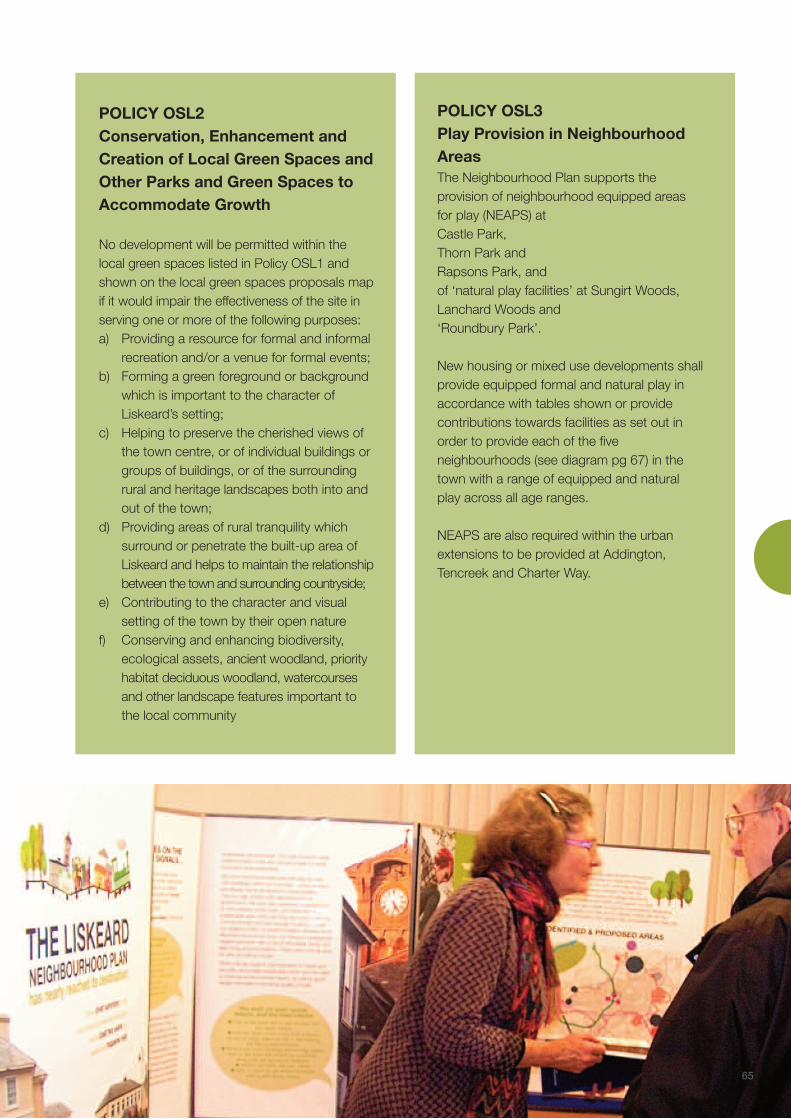


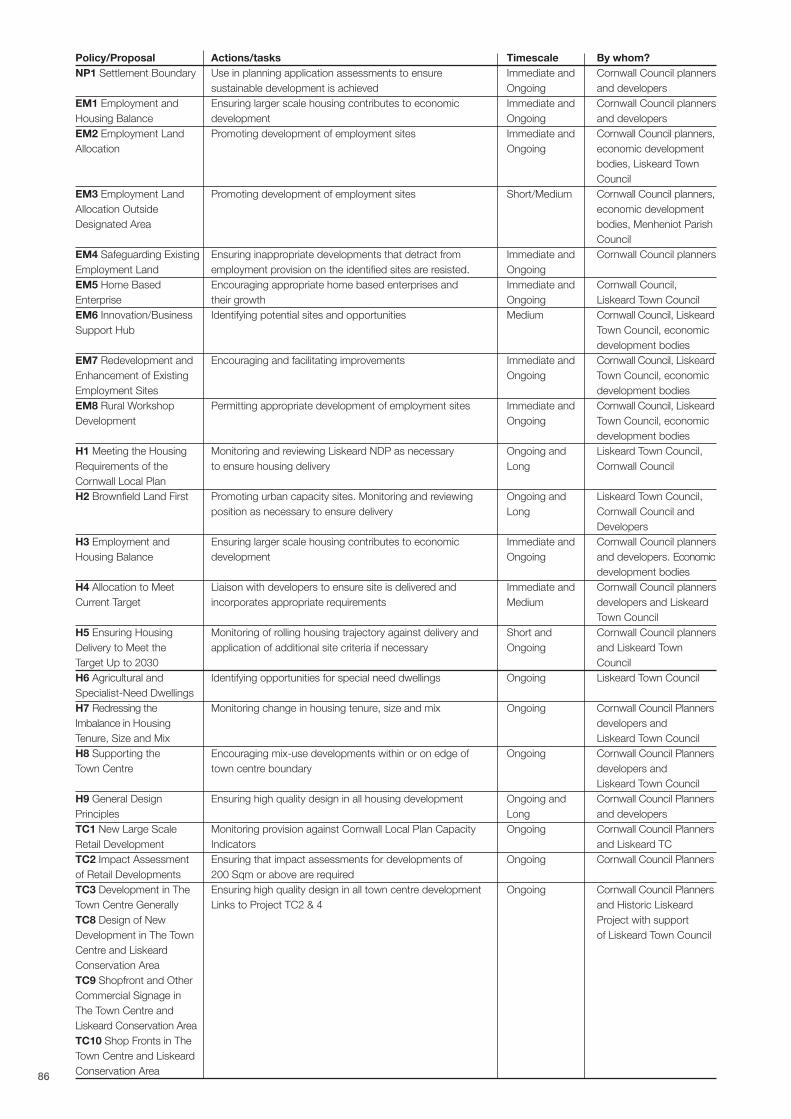
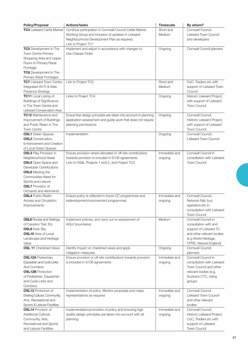
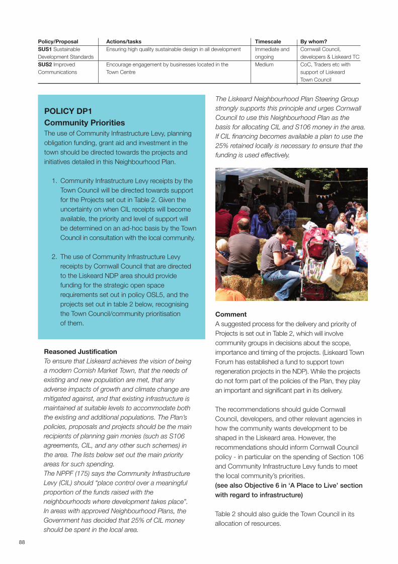
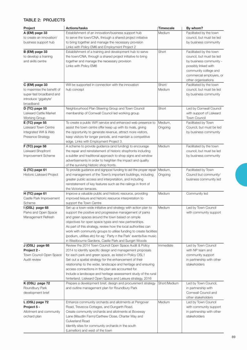


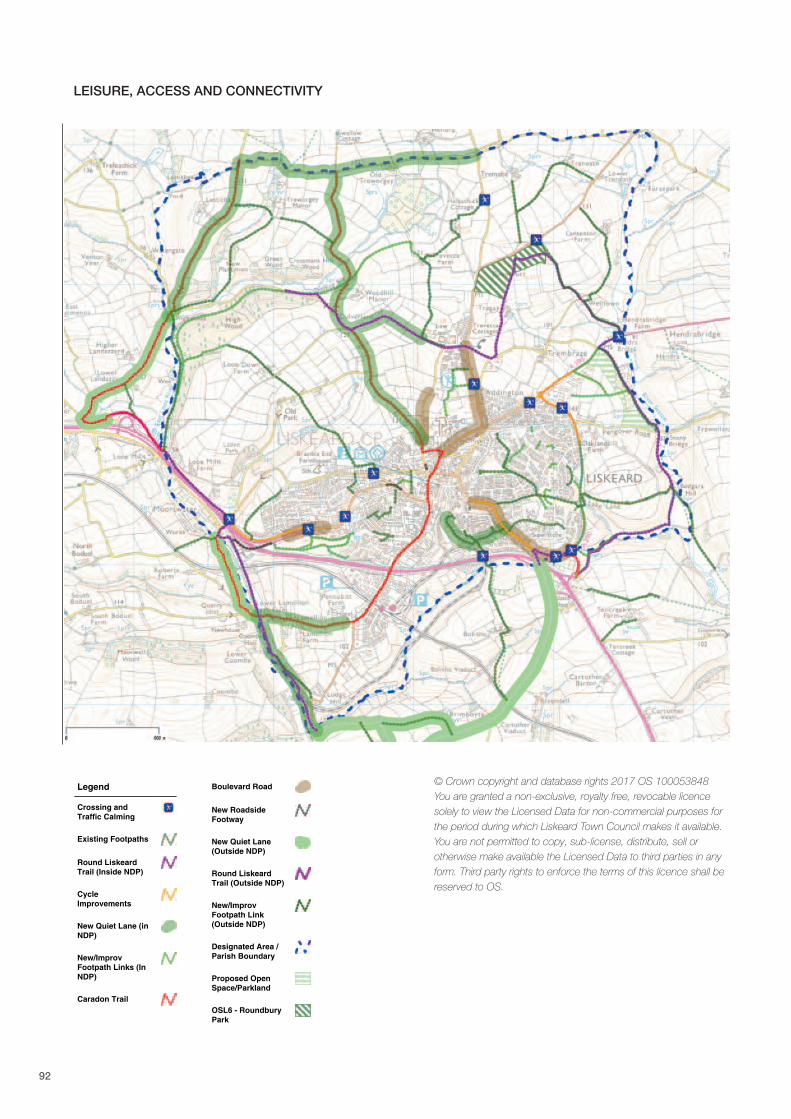
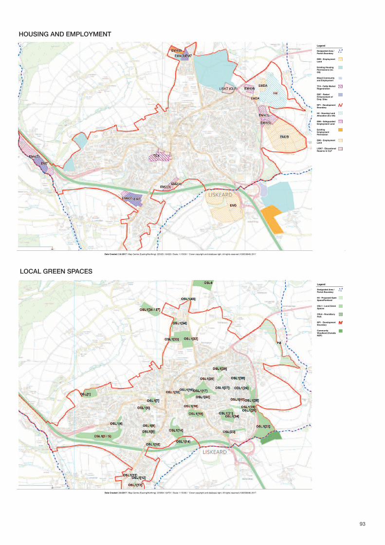


![bioone.org€¦ · 0 lf h / d f n lq j wk h 8 6 3 ' h x e lt x lwlq d wlq j ( q ]\ p h + d y h 6 h y h uh 0 d oh 6 x e ih uwlolw\ $ v v r f ld wh g z lwk ' h ih f wv lq) h uwlol]d](https://static.documents.pub/doc/80x56/5eb66830c21bf6534935e481/0-lf-h-d-f-n-lq-j-wk-h-8-6-3-h-x-e-lt-x-lwlq-d-wlq-j-q-p-h-d-y-h-6-h.jpg)


