9000 Wilshire Boulevard Commercial Project Draft Environmental Impact Report SCH#2016081005 prepared by City of Beverly Hills Planning Division, Department of Community Development 455 North Rexford Drive Beverly Hills, CA 90210 Contact: Masa Alkire, AICP, Principal Planner prepared with the assistance of Rincon Consultants 706 South Hill Street, Suite 1200 Los Angeles, CA 90014 January 2017
Transcript
9000 Wilshire Boulevard Commercial Project
Draft Environmental Impact Report SCH#2016081005
prepared by City of Beverly Hills
Planning Division, Department of Community Development 455 North Rexford Drive
Beverly Hills, CA 90210 Contact: Masa Alkire, AICP, Principal Planner
prepared with the assistance of Rincon Consultants
706 South Hill Street, Suite 1200 Los Angeles, CA 90014
January 2017
This report prepared on 50% recycled paper with 50% post-consumer content.
Table of Contents
Draft Environmental Impact Report i
Table of Contents
Executive Summary ....................................................................................................................................... 1 Project Synopsis .................................................................................................................................... 1 Project Objectives ................................................................................................................................. 5 Alternatives ........................................................................................................................................... 5 Areas of Known Controversy ................................................................................................................. 7 Issues to be Resolved ............................................................................................................................ 7 Issues Not Studied in Detail in the EIR .................................................................................................. 7 Summary of Impacts and Mitigation Measures .................................................................................... 8
1 Introduction ........................................................................................................................................ 15 1.1 Environmental Impact Report Background ............................................................................ 15 1.2 Purpose and Legal Authority................................................................................................... 15 1.3 Scope and Content .................................................................................................................. 19 1.4 Issues Not Studied in Detail in the EIR .................................................................................... 19 1.5 Lead, Responsible, and Trustee Agencies ............................................................................... 23 1.6 Environmental Review Process ............................................................................................... 24
6 Alternatives ......................................................................................................................................... 95 6.1 Alternative 1: No Project Alternative ...................................................................................... 96 6.2 Alternative 2: 9006-9010 Building to Remain ......................................................................... 97 6.3 Alternative 3: 9006-9010 Building Façade to Remain (Niche Scheme) .................................. 99 6.4 Alternative 4: 9006-9010 Building Façade to Remain (Cantilever Scheme) ......................... 101 6.5 Alternatives Considered But Rejected .................................................................................. 102 6.6 Environmentally Superior Alternative .................................................................................. 103
City of Beverly Hills 9000 Wilshire Boulevard Commercial Project
ii
7 References......................................................................................................................................... 107 7.1 Bibliography .......................................................................................................................... 107 7.2 List of Preparers .................................................................................................................... 108
City of Beverly Hills 9000 Wilshire Boulevard Commercial Project
iv
This page left intentionally blank.
Executive Summary
Draft Environmental Impact Report 1
Executive Summary
This document is an Environmental Impact Report (EIR) analyzing the environmental effects of the proposed 9000 Wilshire Boulevard Commercial Project (proposed project). This section summarizes the characteristics of the proposed project, alternatives to the proposed project, and the environmental impacts and mitigation measures associated with the proposed project.
Project Synopsis
Project Applicant 9000 Wilshire LLC 1805 Colorado Avenue Santa Monica, CA 90404 (310) 447-3000
Lead Agency Contact Person Masa Alkire, AICP, Principal Planner City of Beverly Hills Community Development Department 455 North Rexford Drive, First Floor Beverly Hills, CA 90210 (310) 285-1135
Project Description This EIR has been prepared to examine the potential environmental effects of the 9000 Wilshire Boulevard Commercial Project. The following is a summary of the full project description, which can be found in Section 2.0, Project Description.
The project site is comprised of two lots located at 9000-9010 Wilshire Boulevard on the southwest corner at the intersection of Wilshire Boulevard and S. Almont Drive in the City of Beverly Hills. The project site is relatively flat and rectangular with an area of 15,876 square feet (0.36 acres), and the Assessor Parcel Numbers are 4331-028-003 and 4331-028-004. The site is located in a C-3 Commercial Zone, with a General Plan Land Use designation of Low Density Commercial, which allows commercial development with a Floor Area Ratio up to 2.0 and height of 45 feet (Beverly Hills, 2010a). The proposed project would not require amendments to the City’s General Plan or the Beverly Hills Municipal Code (BHMC).
The project site is currently developed with a one-story retail building located at 9006-9010 Wilshire Boulevard and a two-story retail building located at 9000 Wilshire Boulevard. The two-story building is currently occupied by an antique/art shop, and the one-story building consists of three retail spaces that are occupied by a café, vape shop/lounge, and an insurance office. These two buildings cover an area (building footprint) of 6,832 square feet, approximately 44 percent of the project site. A paved parking lot approximately 5,500 square feet in size is located behind the buildings, adjacent to the alley along the southern boundary of the site.
City of Beverly Hills 9000 Wilshire Boulevard Commercial Project
2
Project Characteristics The proposed project would involve demolition of the two existing commercial retail buildings and removal of the paved parking lot. After demolition, a new 31,702 square-foot building would be constructed, which would consist of three stories of commercial office development and four levels of subterranean parking. The proposed project would also include a rooftop lunchroom, drought-tolerant landscaping, bike storage, and a total of 91 parking spaces for occupants. Plans for the proposed project are included in Appendix A of this EIR. Table 1 summarizes the project characteristics.
Table 1 Project Characteristics
Address 9000-9010 Wilshire Boulevard
APN 4331-028-003 & 4331-028-004
Height/Stories 45 feet + 15 feet for rooftop lunchroom1
3 stories above grade, plus rooftop lunchroom and terrace eating area 4 stories below grade for basement parking
Lot Area 15,876 square feet (sf)
Building Footprint Approx. 14,558 sf
Total Floor Area 31,702 sf2
Parking Level 4 6,091 sf
Parking Level 3 14,101 sf
Parking Level 2 14,101 sf
Parking Level 1 13,154 sf
Ground Floor 8,006 sf
2nd Floor 11,348 sf
3rd Floor 12,348 sf
Rooftop Lunchroom 2,049 sf
Land Uses:
Commercial Office (Ground, 2nd, 3rd Floors) 31,702 sf
Rooftop Lunchroom 2,049 sf
Below-Grade Parking (Levels 1-4) 47,447 sf 1 Rooftop penthouse structures, including lunchroom and eating area, in accordance with BHMC §10-3-3107 are exempt from the height restrictions given that additional height does not exceed 15 feet 2 The total floor area is calculated pursuant to BHMC §10-3-100 and does not include parking areas, elevator shafts, stair shafts, rooms housing building operating equipment or machinery rooms, rooftop lunchrooms, or areas outside the surrounding walls of a building or structure. Total floor area is the sum of the ground, 2nd and 3rd floors.
sf = square feet
The 14,558 square-foot building footprint would occupy approximately 92 percent of the 15,876 square-foot lot. The proposed building would have a total floor area of 31,702 square feet of commercial space (not including parking areas, elevator and stair shafts, mechanical rooms housing operating equipment or machinery) and a 2,049 square-foot rooftop lunchroom for building occupants only. Outdoor patios would be provided on the second floor and roof. The proposed building would also include four levels of subterranean parking with a total floor area of 47,447 square feet. The proposed building would have a height of 45 feet to the top of the roof. The proposed rooftop penthouse structures, including a lunchroom, eating area, and painted steel brise soleil (perforated screen to filter sunlight), would extend
Executive Summary
Draft Environmental Impact Report 3
an additional 15 feet from the top of the roof. Architecturally, the building would be characterized by clear glass curtain walls with dark metal panels between floors and at the rooftop parapet. A green wall planting with climbing vegetation at the outdoor terrace on the second floor would serve as an accent, visible from street level at Wilshire Boulevard.
Table 2 compares existing conditions to the proposed project with respect to building footprint and height.
Table 2 Summary of Proposed Changes Existing Development Proposed Project Change
Building Footprint 9000 Wilshire Blvd: 3,825 sf 9006-9010 Wilshire Blvd: 3,007 sf Total: 6,832 sf
1 Rooftop penthouse structures, including lunchroom and eating area, in accordance with BHMC §10-3-3107 are exempt from the height restrictions given that additional height does not exceed 15 feet.
Drought-tolerant landscape would be integrated throughout the building. Ornamental grasses, shrubs, and herbaceous plants would border the rooftop lunch terrace and second floor terrace area. Bamboo would be planted as a screen for the rooftop lunch terrace, second floor terrace area, and the southwest corner of the ground floor. A green wall planting with climbing vines would be planted on the second floor terrace area, against the building to the west of the site. A large privacy screen of juniper trees, eventually reaching a height of 15-30 feet at maturity, would be planted at the southern edge of the project site. One Chinese elm street tree would be removed from S. Almont Drive near the southeast corner of the site to clear space for the proposed curb cut.
Parking and Site Access The proposed project would include four levels of subterranean parking with 91 parking spaces with a total area of 47,447 square feet. Four spaces would be accessible to persons with disabilities and 11 racks would be installed for bicycle parking. Vehicular access to the project site would be provided from S. Almont Drive and the rear alley. Pedestrians would access the proposed building from double-door entrances on Wilshire Boulevard and S. Almont Drive and an egress door at the northwest corner of the building on Wilshire Boulevard.
The existing curb cut on S. Almont Drive would be removed and a new one would be constructed at the southeast edge of the site. This 42-foot, 6-inch-wide curb cut would serve as an entry/exit point for a 22-foot-wide driveway leading to the underground parking garage and the exit to an adjacent loading dock. Vehicles would enter the loading dock via the alley. A 2-foot, 6-inch strip along the southern boundary of the project site would be set aside as a public right-of-way dedication for the alley.
Utilities The City of Beverly Hills Public Works Department provides the following utility services: solid waste, water, wastewater, and stormwater. Southern California Edison supplies electricity and the Southern California Gas Company provides natural gas to the City of Beverly Hills.
City of Beverly Hills 9000 Wilshire Boulevard Commercial Project
4
Construction and Grading Construction of the proposed project is expected to occur over approximately 18 months. Construction activities would be separated into four phases. The first phase would include initial site preparation and demolition of existing buildings; the second phase would include shoring and mass excavation; and the third phase would include construction of subterranean parking and the building, glazing system installation, and roofing. During the second phase, the maximum depth of excavation would be approximately 44 feet and the total amount of exported soil associated with excavation would be approximately 25,872 cubic yards. The fourth construction phase would involve core and shell buildout, which would include the elevator installation. Construction equipment for the project would include earthwork equipment such as drills for shoring, crane, concrete pump, and miscellaneous small tools.
Green Building Features The proposed project’s overall design would meet Leadership in Energy and Environmental Design (LEED) Gold or equivalent standards, , which would be achieved by using less water and energy and reducing greenhouse gas emissions compared to a non-certified LEED commercial building. A building can earn credits toward LEED certification through performance in five key areas including sustainable sites, water savings, energy and atmosphere, materials and resources, and indoor environmental quality. The sixth category, innovation and design process, awards points for exceeding the minimum criteria in the first five categories (LEED, 2016). Solar panels and water conservation elements would be incorporated into the project design to reduce the building’s energy utilization and achieve LEED certification. Half of the roof would contain solar panels to capture solar energy.
Applicant Proposed Project Design Features (PDFs) The City of Beverly Hills General Plan, Chapter 5 (Open Space), contains policies intended to protect, enhance and expand open space resources, remaining natural areas, and significant wildlife and vegetation in the City (Goal OS 1) including nesting birds. Implementation of Biological PDF 1, intended to be applied to the project permit conditions of approval for consistency with the City’s General Plan, would ensure no impacts would occur to nesting birds and consistency with the City of Beverly Hills General Plan (Goal OS 1 and Policy OS 1.1), the California Department of Fish and Game (CDFG) Code, and the Migratory Bird Treaty Act. Biological PDF 1 ensures consistency with General Plan Goal OS 1 by requiring protection for nesting birds within the City.
Biological PDF 1 – Avoid Bird Nesting Season or Conduct a Nesting Bird Survey and Provide Buffers. Vegetation removal and initial ground disturbance must occur either:
a) Outside the bird and raptor breeding season, which is typically January 1 through August 31, or b) If vegetation clearing occurs during the breeding season, one pre-construction bird nesting
survey shall be conducted not more than one week prior to vegetation clearing to determine the locations of nesting birds. The bird survey shall be conducted by a qualified biologist. If a nesting bird or special status species is located, consultation with the local California Department of Fish and Wildlife (CDFW) representative shall occur to determine what avoidance actions may be taken. Generally, if an active bird nest is found, a minimum 100-foot buffer (or as otherwise directed by CDFW) would be established surrounding the nest(s), which shall be flagged for avoidance. The results of the nesting bird survey(s) and any buffer efforts as a result of those surveys shall be documented in a brief letter report and submitted to the City and the CDFW prior to commencement of clearing.
Implementation of Geological PDF 1 and Geological PDF 2 from the Geotechnical Engineering Investigation for the Proposed Commercial Office Building, 9000 Wilshire Boulevard, Beverly Hills, California would ensure that the proposed building would not be affected by expansive soils.
Executive Summary
Draft Environmental Impact Report 5
Geological PDF 1 – Foundation Design. Due to the depth of the proposed subterranean levels relative to the historically highest groundwater level, the proposed structure shall be designed to resist hydrostatic and uplift pressures based on the historically highest groundwater level. Therefore, the proposed structure shall be supported on a mat foundation bearing on the underlying native soils, at the lowest level of the subterranean parking garage. An allowable bearing pressure of 5,000 pounds per square foot shall be utilized in the design of the proposed mat foundation. The mat foundation shall be designed utilizing a modulus of subgrade reaction of 200 kilo pounds (kips) per cubic foot. The thickness of the mat foundation shall be designed by the project structural engineer. The bottom of the mat foundation shall be a minimum of 18 inches in depth below the lowest adjacent grade at the perimeter of the structure. Proper waterproofing shall be provided below the base of the mat and a waterproofing consultant shall be retained in order to recommend appropriate products and methods to waterproof below the mat.
Where necessary, uplift anchors may be designed to provide resistance against the anticipated hydrostatic uplift pressures acting on the mat foundations. Uplift anchors shall be a minimum of 12 inches in diameter, and shall be embedded a minimum of 20 feet into the underlying native soils. Uplift anchors shall be designed using a frictional capacity of at least 1.5 kips per lineal foot.
Geological PDF 2 – Concrete Slabs-on-Grade. Slabs-on-grade shall be cast over undisturbed native soils or properly compacted fill materials. Any geologic materials loosened or over-excavated shall be wasted from the site or properly compacted to 90 percent of the maximum dry density. Outdoor concrete flatwork shall be a minimum of 4 inches in thickness and shall be cast over undisturbed native soils or properly compacted fill material.
Project Objectives Promote economic sustainability by attracting prominent firms in key business sectors that
contribute to the City’s identity, culture, and economy; provide high-paying jobs; and generate revenue for the City. Such businesses include entertainment-related and other high-profile firms that seek Class-A creative office buildings.
Build to a standard considered Class-A office, which includes features such as high-quality architectural design and building materials, prominent placement of the building on the site, and floor plates that accommodate Class-A office users and allow efficient use of the space.
Design a commercial building located adjacent to a residential neighborhood that ensures the integrity and quality of both the commercial and residential neighborhoods.
Design and construct a project in accordance with the City’s Green Building Ordinance that incorporates energy, water, and natural resource conservation features and a construction program that minimizes waste and the use of toxic and hazardous materials.
Alternatives As required by the California Environmental Quality Act (CEQA), this EIR examines alternatives to the proposed project. Studied alternatives include the following four alternatives. Based on the alternatives analysis, Alternative 3 was determined to be the environmentally superior alternative.
Alternative 1: No Project/Existing 9000-9010 Buildings to Remain Alternative 2: 9006-9010 Building to Remain Alternative 3: 9006-9010 Building Façade to Remain (Niche Scheme) Alternative 4: 9006-9010 Building Façade to Remain (Cantilever Scheme)
City of Beverly Hills 9000 Wilshire Boulevard Commercial Project
6
Alternative 1 (No Project/Existing 9000-9010 Buildings to Remain) assumes that the proposed commercial building, subterranean parking, and other accessories associated with the proposed project would not be constructed. Current uses on the project site consist of a one-story retail building located at 9006-9010 Wilshire Boulevard and a two-story retail building located at 9000 Wilshire Boulevard that would remain. Of the two commercial buildings, the one-story retail building at 9006-9010 Wilshire Boulevard was constructed in 1924 and designed in the Mediterranean Revival style. This building is eligible for listing in the National Register of Historic Places (NRHP) and the California Register of Historic Resources (CRHR) under Criteria A/1 for its association with the early commercial development of Wilshire Boulevard and Criteria C/3 as a rare remaining example of Mediterranean Revival commercial architecture along the Wilshire corridor within Beverly Hills. Under this alternative, demolition of the 9006-9010 Wilshire building would not occur and significant impacts to potential historic resources would be avoided. In addition, no construction would occur; therefore, the mitigation measures associated with monitoring for cultural resources and the reviews and plans for traffic and transportation would not be required. However, Alternative 1 would not fulfill the Project Objectives because the existing conditions would not promote high-profile economic activity on the project site, and there would be no design or construction of a Class-A commercial building under the City’s Green Building Ordinance.
Alternative 2 (9006-9010 Building to Remain) would involve demolition of the two-story retail building located at 9000 Wilshire Boulevard to construct a commercial office building with a roof deck. Under this alternative, the 9006-9010 Wilshire building would not be demolished and the preserved building would be used as an entryway/lobby to the rest of the building, which would result in an office use instead of the current retail use. Preservation of the 9006-9010 Wilshire building under Alternative 2 would eliminate the significant and unavoidable historic impact. However, under this alternative, the proposed building would exceed the maximum allowed height and Floor Area Ratio in the C-3 Commercial Zone, and the proposed number of parking spaces would not meet the minimum parking requirement. Therefore, development under this alternative would require either legislative approvals to modify the General Plan and Zoning Code, or local landmarking of the 9006-9010 Wilshire building and discretionary approvals (Historic Incentive Permit) that would not be required under the proposed project. In addition, in comparison to the proposed project, this alternative would result in an increase in traffic impacts on local roadways and would require an additional CMP traffic impact analysis. Also, as with the proposed project, the same mitigation measures during the construction period for cultural resources and transportation/traffic would be required. Overall, Alternative 2 would not be considered environmentally superior, particularly due to the legislative or discretionary approvals that would be required under this alternative.
Alternative 3 (9006-9010 Building Façade to Remain [Niche Scheme]) would involve demolition of the two-story retail building located at 9000 Wilshire Boulevard to construct a three-story commercial office building with a roof deck. Partial demolition of the 9006-9010 Wilshire building would occur to keep the façade and tile roof architecture that qualifies that building as eligible for listing in both the NRHP and the CRHR. The preserved portion of the building would be used as an entryway/lobby to the rest of the building, which would result an office use instead of retail. Preservation of the façade would minimize the impact to historic resources, which would reduce the impact to less than significant, as opposed to significant and unavoidable under the proposed project. Under this alternative, traffic impacts to residential streets and the CMP would be less than those of the proposed project due to an overall decrease in vehicle trips. In addition, the building height, Floor Area Ratio, and parking spaces would be consistent with the requirements established for the C-3 Commercial Zone. During construction, as with the proposed project, implementation of the same mitigation measures for cultural resources and transportation/traffic would be required. Overall, in comparison to the proposed project, Alternative 3 would eliminate the significant and unavoidable historic impact and would also result in decreased
Executive Summary
Draft Environmental Impact Report 7
impacts related to transportation and traffic. Therefore, Alternative 3 would be the environmentally superior alternative.
Alternative 4 (9006-9010 Building Façade to Remain [Cantilever Scheme]) would involve demolition of the two-story retail building located at 9000 Wilshire Boulevard to construct a commercial office building with a roof deck. Similar to Alternative 3, partial demolition of the rear part of the 9006-9010 Wilshire building would occur and the preserved building would be used as an entryway/lobby to the rest of the building, which would result in an office use instead of the current retail use. However, the proposed project would overhang the remaining façade of the 9006-9010 Wilshire building and would not provide enough visual distinction between the preserved and new buildings. Preservation of the façade would minimize the impact to historic resources as opposed to current plans for the proposed project, but not to a level of less than significant. In addition, under this alternative, impacts related to residential streets and the CMP would be greater than those of the proposed project due to overall increase in vehicle trips. In addition, the proposed building would exceed the maximum allowed height and Floor Area Ratio in the C-3 Commercial Zone, and the proposed number of parking spaces would not meet the minimum parking requirement. Therefore, development under this alternative would require legislative approvals to amend the General Plan and Zoning Code that would not be required under the proposed project. During the construction period, as with the proposed project, implementation of the same mitigation measures for cultural resources and transportation/traffic would be required. Overall, in comparison to the proposed project, Alternative 4 would reduce the significant and unavoidable historic impact, but not to a level of less than significant. In addition, impacts to land use and planning and transportation and traffic would increase. As such, Alternative 4 would not be the environmentally superior alternative.
Refer to Section 6.0, Alternatives, for the complete alternatives analysis.
Areas of Known Controversy The EIR scoping process did not identify any areas of known controversy for the proposed project. Responses to the Notice of Preparation of a Draft EIR and input received at the EIR scoping meeting held by the City are summarized in Section 1.0, Introduction.
Issues to be Resolved The proposed project would require a demolition and building permit. In addition, Planning Commission approval of a discretionary permit/entitlement for Development Plan Review of a new building and a rooftop lunchroom would be required.
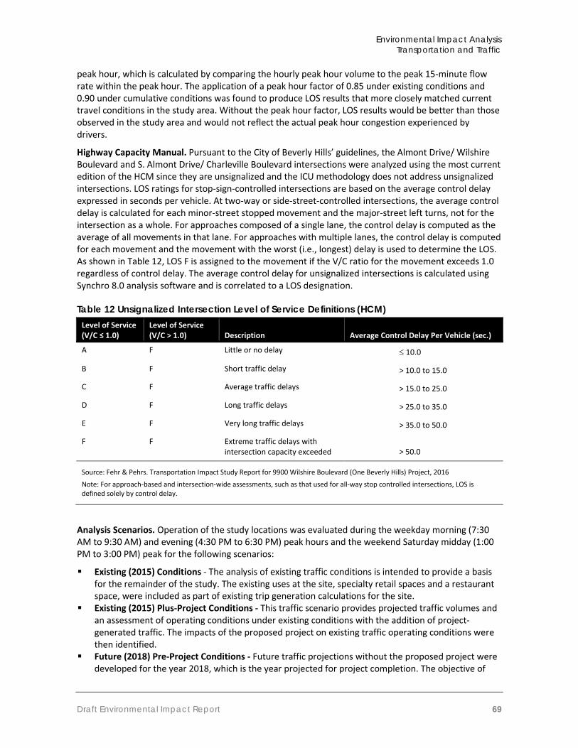
Issues Not Studied in Detail in the EIR Table 5 in Section 1.4 summarizes issues from the environmental checklist that were addressed in the Initial Study (Appendix B). As indicated in the Initial Study, there is no substantial evidence that significant impacts would occur to the following issue areas: Aesthetics, Agricultural Resources, Air Quality, Biological Resources, Geology/Soils, Greenhouse Gas Emissions, Hazards and Hazardous Materials, Hydrology, Land Use and Planning, Mineral Resources, Noise, Population/Housing, Public Services, Recreation, and Utilities. Impacts to Cultural Resources were found to be potentially significant and are addressed in this EIR. Impacts to Traffic/Transportation were not found in the Initial Study to be potentially significant; however it is further analyzed in this EIR for the purposes of public review and comment.
City of Beverly Hills 9000 Wilshire Boulevard Commercial Project
8
Summary of Impacts and Mitigation Measures Table 3 summarizes the environmental impacts of the proposed project, proposed mitigation measures, and residual impacts (the impact after application of mitigation, if required). Although distinct from mitigation measures, project design features (PDFs) are also listed because they will be included as conditions of approval by the City to avoid potential biological and geological impacts. Impacts are categorized as follows:
Significant and Unavoidable: An impact that cannot be reduced to below the threshold level given reasonably available and feasible mitigation measures. Such an impact requires a Statement of Overriding Considerations to be issued if the project is approved per §15093 of the CEQA Guidelines.
Less than Significant with Mitigation Incorporated: An impact that can be reduced to below the threshold level given reasonably available and feasible mitigation measures. Such an impact requires findings under §15091 of the CEQA Guidelines.
Less than Significant: An impact that may be adverse, but does not exceed the threshold levels and does not require mitigation measures. However, mitigation measures that could further lessen the environmental effect may be suggested if readily available and easily achievable.
No Impact: The proposed project would have no effect on environmental conditions or would reduce existing environmental problems or hazards.
Table 3 Summary of Environmental Impacts, Mitigation Measures, and Residual Impacts Impact Mitigation Measure (s) Residual Impact
Cultural Resources
Impact CR-1 The project site contains a building that is eligible for listing as a historic resource. Construction of the proposed project would involve demolition of the building located at 9006-9010 Wilshire Boulevard. Due to this irreversible loss of a potential historic resource, this impact would be significant and unavoidable
MM CR-1 Building Recordation. Impacts resulting from the demolition of the commercial building at 9006-9010 Wilshire Boulevard shall be minimized through archival documentation of as-built and as-found condition. Prior to issuance of demolition permits, the lead agency shall ensure that documentation of the buildings and structures proposed for demolition is completed that follows the general guidelines of Historic American Building Survey (HABS) documentation. The documentation shall include high resolution digital photographic recordation, a historic narrative report, and compilation of historic research. The documentation shall be completed by a qualified architectural historian or historian who meets the Secretary of the Interior’s Professional Qualification Standards for History and/or Architectural History. The original archival-quality documentation shall be offered as donated material to repositories that will make it available for current and future generations. Archival copies of the documentation also would be submitted to the City of Beverly Hills and the Beverly Hills Public Library, where it would be available to local researchers. Completion of this mitigation measure shall be monitored and enforced by the City of Beverly Hills. MM CR-2 Interpretive Plaque. Impacts related to the loss of the commercial building at 9006 Wilshire Boulevard shall be reduced through the installation of an interpretive plaque at the site discussing the history of the building, its significance, important details and features, and the historic Wilshire corridor. The plaque can be installed on a publicly-accessed building on the project site or a publicly-accessed
Although the photo documentation will reduce the impact to a certain degree, it would remain Significant and Unavoidable.
Executive Summary
Draft Environmental Impact Report 9
Impact Mitigation Measure (s) Residual Impact outdoor location. The plaque shall include images and details from the HABS documentation and any collected research pertaining to the historic property. The content shall be prepared by a qualified architectural historian or historian who meets the Secretary of the Interior’s Professional Qualification Standards for History and/or Architectural History (NPS 1983). Installation of the plaque shall be completed within one year of the date of completion of the proposed project. Completion of this mitigation measure shall be monitored and enforced by the City of Beverly Hills. MM CR-3 Salvaging Plan. Impacts related to the loss of the commercial building at 9006 Wilshire Boulevard shall be reduced through the salvaging of historic architectural features and materials to be offered to architectural salvaging organizations. An inventory with brief descriptions of salvageable items shall be created to provide to architectural salvaging organizations. Completion of this mitigation measure shall be monitored and enforced by the City of Beverly Hills.
Impact CR-2 Construction of the proposed project would involve ground-disturbing activities such as grading and surface excavation, which have the potential to unearth or adversely impact previously unidentified archaeological resources, paleontological resources, human remains, and/or tribal cultural resources. Impacts would be less than significant with mitigation incorporated.
MM CR-4 Retain a Qualified Principal Investigator. A qualified principal investigator, defined as an archaeologist, who meets the Secretary of the Interior’s Standards for professional archaeology and has previous experience working in Los Angeles County, shall be retained to carry out all mitigation measures related to archaeological and historical resources (hereafter qualified archaeologist). The qualified archaeologist shall be contacted in the event of an inadvertent archaeological discovery. MM CR-5 Preconstruction Worker Training. At the project kickoff and before construction activities begin, the qualified archaeologist or their designee will provide training to construction personnel on information regarding regulatory requirements for the protection of cultural resources including tribal cultural resources. As part of this training, construction personnel will be briefed on proper procedures to follow should unanticipated cultural resources discoveries be made during construction. Workers will be provided contact information and protocols to follow in the event that inadvertent discoveries are made. If necessary, the qualified archaeologist can create a training video, PowerPoint presentation, or printed literature that can be shown to new workers and contractors to avoid continuous training throughout the course of the project. MM CR-6 Retain a Native American Monitor. A Native American monitor who is ancestrally related to the project area shall be retained to be on site to monitor all project-related, ground-disturbing construction activities (i.e., grading, excavation, potholing, etc.) within previously undisturbed soils. The Gabrieleño Band of Mission Indians – Kizh Nation shall provide the Native American monitor. Should the Gabrieleño Band of Mission Indians – Kizh Nation not have sufficient qualified staff, or not provide services at market rates, the applicant may contract with a different firm to provide a Native American monitor,
Less than significant
City of Beverly Hills 9000 Wilshire Boulevard Commercial Project
10
Impact Mitigation Measure (s) Residual Impact
subject to approval by the City of Beverly Hills Director of Community Development. MM CR-7 Unanticipated Discovery of Archaeological Resources. In the event that archaeological resources are exposed during construction, work in the immediate vicinity and within 50 feet of the find must stop until a qualified archaeologist can evaluate the significance of the find. Construction activities may continue in areas 50 feet away from the find. If the discovery proves significant under CEQA (Section 15064.5f; PRC 21082), additional work such as testing or data recovery may be warranted. A Cultural Resources Monitoring and Mitigation Plan will be developed to outline monitor procedures. MM-CR-8 Unanticipated Discovery of Tribal Cultural Resources. In the event the Native American monitor identifies cultural or archeological resources, the monitor shall be given the authority to temporarily halt construction in the immediate vicinity and within 50 feet of the discovery and to contact the qualified archaeologist to investigate the find and determine if it is a tribal cultural resource under CEQA by the City of Beverly Hills in consultation with the ancestrally related tribe(s) and qualified archaeologist. Construction activities can continue in areas 50 feet away from the find and not associated with the cultural resource location. If the discovery proves to be significant, additional work such as testing or data recovery may be warranted. A Cultural Resources Monitoring and Mitigation Plan will be developed to outline monitor procedures. MM CR-9 Unanticipated Discovery of Human Remains. In the event that human remains are encountered at the project site, all work in the immediate vicinity of the burial must cease, and any necessary steps to ensure the integrity of the immediate area shall be taken. The Los Angeles County Coroner will be immediately notified. The Coroner must then determine whether the remains are Native American. Should the Coroner determine the remains are Native American, the Coroner has 24 hours to notify the Native American Heritage Commission (NAHC), who shall in turn, notify the person they identify as the most likely descendent (MLD). Further actions shall be determined in part by the recommendations of the MLD. The MLD has 48 hours of being granted access to the project site to complete their inspection and make recommendations or preferences for treatment of the remains. If the MLD does not make recommendations within 48 hours, the owner shall, with appropriate dignity, re-inter the remains in an area of the property secure from further disturbance. Alternatively, if the owner does not accept the MLD’s recommendations, the owner or the descendent may request mediation by the NAHC. Procedures of conduct following the discovery of human remains have been mandated by Health and Safety Code §7050.5, Public Resources Code §5097.98, and the California Code of Regulations §15064.5(e) (CEQA).
Executive Summary
Draft Environmental Impact Report 11
Impact Mitigation Measure (s) Residual Impact
Transportation and Traffic
Impact T-1 Implementation of the proposed project would generate traffic at study area intersections; however, project-generated traffic would not cause any intersection to exceed city standards under existing plus project traffic conditions. Impacts associated with the proposed project would be less than significant.
None required Less than significant
Impact T-2 Implementation of the proposed project would increase traffic on residential streets east and south of the project site along S. Almont Drive. However, project-generated traffic would not exceed city thresholds under existing plus project conditions on any street segment. Impacts to residential streets would therefore be less than significant.
None required Less than significant
Impact T-3 Project driveways would provide adequate site access and would not create hazardous traffic conditions. Therefore, impacts associated with the proposed project would be less than significant with implementation of mitigation.
MM TRAF-1 Driveway Plans. As a condition of approval, the applicant shall design the driveway ingress/egress to include pedestrian safety measures such as flashing lights along S. Almont Drive to indicate to pedestrians when vehicles are exiting the project driveway. The project shall include a pavement stop marking for vehicles leaving the project driveway and loading area prior to entering the public sidewalk and driveway visibility triangles such that drivers’ and pedestrians’ views are not blocked by the proposed wall and hedge on the southern property line of the site.
Less than significant
Impact T-4 The proposed project does not include design features that would impede emergency access vehicles. Impacts associated with the proposed project would be less than significant.
None required Less than significant
Impact T-5 The proposed project would not involve any disruptions to the local active transportation system. Further, the proposed project would not conflict with applicable policies associated with public transit. Therefore, impacts in this regard would be less than significant with implementation of mitigation.
Refer to MM TRAF-1 Driveway Plans. Refer to MM TRAF-1. Less than significant
Impact T-6 Construction activities for the proposed project would result in traffic impacts due to haul truck traffic, equipment and material deliveries, worker traffic, and worker parking. Impacts associated with construction of the proposed project
MM TRAF-2 Construction Traffic Management Plan. The applicant shall create a Construction Traffic Management Plan to minimize traffic flow interference from construction activities. The Construction Traffic Management Plan shall be subject to review and approval by the Director of Community Development or his/her designee and shall include plans to accomplish the following:
Less than significant
City of Beverly Hills 9000 Wilshire Boulevard Commercial Project
12
Impact Mitigation Measure (s) Residual Impact
would be less than significant with mitigation incorporated.
Every stage of construction requires a traffic plan to be reviewed by the Director of Community Development or his/her designee;
Maintain existing access for land uses in the proximity of the project site during project construction;
Schedule deliveries and pick-ups of construction materials for non-peak travel periods, to the maximum extent feasible;
Coordinate haul trucks, deliveries and pick-ups to reduce the potential for trucks waiting to load or unload for protracted periods of time; the project shall be limited to a certain number of truck trips per hour, to be identified by the Director of Community Development;
Wash the tires of trucks before trucks leave the project site;
Minimize obstruction of through-traffic lanes on Wilshire Boulevard;
Designated transport routes for heavy trucks and haul trucks to be used over the duration of the proposed project;
No staging of trucks shall occur within the public right-of-way within the City of Beverly Hills;
Establish requirements for loading/unloading and storage of materials on the project site, where parking spaces would be encumbered, length of time traffic travel lanes can be encumbered, sidewalk closings or pedestrian diversions to ensure the safety of the pedestrian and access to local businesses;
Coordinate with adjacent businesses and emergency service providers to ensure adequate access exists to the project site and neighboring businesses; and
No construction worker parking shall be allowed on streets and alleys adjacent to the project site. Provide a construction parking plan.
The Construction Traffic Management Plan shall be submitted and approved by the Director of Community Development or his/her designee prior to issuance of a demolition, grading, or building permit, whichever comes first.
MM TRAF-3 Construction Workers Parking Plan. The applicant shall submit a Construction Workers Parking Plan identifying parking locations for construction workers prior to the issuance of demolition, grading, or building permit, whichever comes first. To the maximum extent feasible, all worker parking shall be accommodated on the project site. During construction activities when construction worker parking cannot be accommodated on the project site, the Plan shall identify alternate parking locations for construction workers and specify the method of transportation to and from the project site for approval by the Director of Community Development or his/her designee prior to issuance of a demolition, grading or building permit, whichever comes first. The Construction Workers Parking Plan must include appropriate measures to ensure that the parking location requirements for construction workers will be strictly enforced. These include
Executive Summary
Draft Environmental Impact Report 13
Impact Mitigation Measure (s) Residual Impact
but are not limited to the following measures: All construction contractors shall be provided with
written information on where their workers and their subcontractors are permitted to park and provide clear consequences to violators for failure to follow these regulations. This information will clearly state that no parking is permitted on residential streets including S. Almont Drive and Charleville Boulevard; and
In lieu of the above, the project applicant/construction contractor has the option of phasing demolition and construction activities such that all construction worker parking can be accommodated on the project site throughout the entire duration of demolition, excavation and construction activities.
Project Design Feature (s)
Biological PDF 1 – Avoid Bird Nesting Season or Conduct a Nesting Bird Survey and Provide Buffers. Vegetation removal and initial ground disturbance must occur either: Outside the bird and raptor breeding season, which is typically January 1 through August 31, or If vegetation clearing occurs during the breeding season, one pre-construction bird nesting survey shall be
conducted not more than one week prior to vegetation clearing to determine the locations of nesting birds. The bird survey shall be conducted by a qualified biologist. If a nesting bird or special status species is located, consultation with the local California Department of Fish and Wildlife (CDFW) representative shall occur to determine what avoidance actions may be taken. Generally, if an active bird nest is found, a minimum 100-foot buffer (or as otherwise directed by CDFW) would be established surrounding the nest(s), which shall be flagged for avoidance. The results of the nesting bird survey(s) and any buffer efforts as a result of those surveys shall be documented in a brief letter report and submitted to the City and the CDFW prior to commencement of clearing.
Geological PDF1 – Foundation Design. Due to the depth of the proposed subterranean levels relative to the historically highest groundwater level, the proposed structure shall be designed to resist hydrostatic and uplift pressures based on the historically highest groundwater level. Therefore, the proposed structure shall be supported on a mat foundation bearing on the underlying native soils, at the lowest level of the subterranean parking garage. An allowable bearing pressure of 5,000 pounds per square foot shall be utilized in the design of the proposed mat foundation. The mat foundation shall be designed utilizing a modulus of subgrade reaction of 200 kilo pounds (kips) per cubic foot. The thickness of the mat foundation shall be designed by the project structural engineer. The bottom of the mat foundation shall be a minimum of 18 inches in depth below the lowest adjacent grade at the perimeter of the structure. Proper waterproofing shall be provided below the base of the mat and a waterproofing consultant shall be retained in order to recommend appropriate products and methods to waterproof below the mat. Where necessary, uplift anchors may be designed to provide resistance against the anticipated hydrostatic uplift pressures acting on the mat foundations. Uplift anchors shall be a minimum of 12 inches in diameter, and shall be embedded a minimum of 20 feet into the underlying native soils. Uplift anchors shall be designed using a frictional capacity of at least 1.5 kips per lineal foot.
Geological PDF 2 – Concrete Slabs-on-Grade. Slabs-on-grade shall be cast over undisturbed native soils or properly compacted fill materials. Any geologic materials loosened or over-excavated shall be wasted from the site or properly compacted to 90 percent of the maximum dry density. Outdoor concrete flatwork shall be a minimum of 4 inches in thickness and shall be cast over undisturbed native soils or properly compacted fill material.
City of Beverly Hills 9000 Wilshire Boulevard Commercial Project
14
This page left intentionally blank.
Introduction
Draft Environmental Impact Report 15
1 Introduction
This document is an Environmental Impact Report (EIR) for a proposed commercial office development located at 9000 Wilshire Boulevard, Beverly Hills, California. The proposed 9000 Wilshire Boulevard Commercial Project (hereafter referred to as the “proposed project” or “project”) would be constructed on a site currently occupied by two commercial buildings. The project would involve demolition of the existing commercial buildings, removal of the paved parking lot and construction of a three-story commercial building. Other components of the project include four levels of subterranean parking, outdoor patios, bike storage, rooftop lunch terrace, and a total of 91 parking spaces for building occupants.
This section discusses (1) the project and EIR background; (2) the legal basis for preparing an EIR; (3) the scope and content of the EIR; (4) issue areas found not to be significant by the Initial Study; (5) the lead, responsible, and trustee agencies; and (6) the environmental review process required under the California Environmental Quality Act (CEQA). The proposed project is described in detail in Section 2.0, Project Description.
1.1 Environmental Impact Report Background The City of Beverly Hills distributed a Notice of Preparation (NOP) of the EIR for a 30-day agency and public review period starting on August 1, 2016 and ending on August 30, 2016. In addition, the City held an EIR Scoping Meeting on August 9, 2016. The meeting, held from 6:00 PM to 7:30 PM, was aimed at providing information about the proposed project to members of public agencies, interested stakeholders and residents/community members. The meeting was held at Beverly Hills City Hall at 455 North Rexford Drive. The City received letters from four agencies in response to the NOP during the public review period, as well as various verbal comments during the EIR Scoping Meeting. The NOP is presented in Appendix B of this EIR, along with the Initial Study that was prepared for the project and the NOP responses received. Table 4 on the following page summarizes the content of the letters and verbal comments and where the issues raised are addressed in the EIR.
1.2 Purpose and Legal Authority The proposed project requires the discretionary approval of the City of Beverly Hills Planning Commission; therefore, the project is subject to the environmental review requirements of CEQA. In accordance with Section 15121 of the CEQA Guidelines (California Code of Regulations, Title 14), the purpose of this EIR is to serve as an informational document that:
“...will inform public agency decision makers and the public generally of the significant environmental effects of a project, identify possible ways to minimize the significant effects, and describe reasonable alternatives to the project.”
This EIR has been prepared as a project EIR pursuant to Section 15161 of the CEQA Guidelines. A Project EIR is appropriate for a specific development project. As stated in the CEQA Guidelines:
“This type of EIR should focus primarily on the changes in the environment that would result from the development project. The EIR shall examine all phases of the project, including planning, construction, and operation.”
City of Beverly Hills 9000 Wilshire Boulevard Commercial Project
16
This EIR is to serve as an informational document for the public and City of Beverly Hills decision makers. The process will include public hearings before the Planning Commission to consider certification of a Final EIR and approval of the proposed project.
Table 4 NOP Comments and EIR Response
Commenter Comment/Request How and Where it was Addressed
Agency Comments Los Angeles County Metropolitan Transportation Authority (LACMTA)
Contact the Metro Bus Operations Control Special Events Coordinator and the Metro Stops and Zones Department regarding construction activities that may impact Metro transit services.
Comments are addressed in Section 4.2, Transportation and Traffic.
Address the effects of noise and vibration from the future completion of the Metro Purple Line Extension in a recorded Noise and Vibration Easement Deed. Any mitigation will be the responsibility of the project applicants.
States the proposed project must not disrupt construction, operation, and maintenance of the Purple Line Extension and its subway tunnels. The Director of Project Engineering Facilities should be contacted regarding potential impacts on the Purple Line Extension.
Encourages the project applicant to provide safe and convenient connections for pedestrians and bicyclists between project and future Wilshire/ Rodeo Purple Line Metro station.
Recommends collaboration between the City and project applicant to provide secure bicycle parking for future project occupants.
States the proposed project would be required to comply with the State of California Congestion Management Program (CMP) statute for a Transportation Impact Analysis (TIA) covering roadways and transit.
A Traffic Impact Study was prepared for the proposed project by KOA Corporation on December 11, 2015.
California Department of Transportation (Caltrans)
Encourages the supply of electric charging stations at some of the spaces in the parking structure to accommodate occupants with electric vehicles.
Comments are addressed in Section 4.2, Transportation and Traffic.
Recommends signage on Wilshire Boulevard and S. Almont Drive to raise awareness of the availability of bicycle parking within the project’s garage.
Encourages implementation of a public bike rack for visitors and “smart bike” users along Wilshire Boulevard (near the main entrance) for convenience.
Encourages upgrading the standard
Introduction
Draft Environmental Impact Report 17
Commenter Comment/Request How and Where it was Addressed
crosswalks at nearby intersections such as Wilshire Boulevard and La Peer Drive to high-visibility continental, or “zebra-striped”, crosswalks.
States the proposed project would require a Caltrans transportation permit for the transportation of heavy construction equipment and/or materials which requires the use of oversized-transport vehicles.
Recommends that large size truck trips be limited to off-peak commute periods.
States that the proposed project would be required to implement design measures to discharge clean runoff water to reduce adverse impacts to storm water runoff.
As discussed in Section IX, Hydrology and Water Quality, of the Initial Study (Appendix B), Best Management Practices (BMPs) would be required during construction and operation of the project to lessen the amount of runoff from the project site to the maximum extent practicable. In addition, the City requires that applicants prepare an urban runoff mitigation plan prior to construction of a project.
Native American Heritage Commission (NAHC)
States that the proposed project is subject to the requirements and provisions under Assembly Bill (AB 52) for tribal cultural resources.
Consultation required by AB 52 was carried out by the City of Beverly Hills. Subsequent issues are discussed in Section 4.1, Cultural Resources, of this EIR and a Cultural Resources Assessment is provided as Appendix C.
South Coast Air Quality Management District (SCAQMD)
Recommends use of CEQA Air Quality Handbook for guidance in preparing air quality analysis and use CalEEMod for analysis.
Section III, Air Quality, in the Initial Study (Appendix B) found, through analysis of California Emissions Estimator Model (CalEEMod) results, that the proposed project’s emissions would be below the SCAQMD’s thresholds for construction and operational emissions and the project would be consistent with the SCAQMD’s Air Quality Management Plan. Further analysis in this EIR was not warranted. Refer to Appendix B for a detailed discussion of air quality impacts and CalEEMod calculations.
Requests construction-related and operation-related air quality analysis, including impacts from indirect sources.
Requests calculation of regional and localized air quality impacts and comparison to SCAQMD thresholds.
Requests mitigation measures to minimize or eliminate significant adverse impacts to air quality.
Public Comments Traffic Regarding the building on the southeast
corner of Wilshire Boulevard/ S. Almont Drive (former ICM building): Currently, much of the office building
sits empty and there is concern that if/when the building does lease up, traffic/ congestion impacts will increase.
Four auto dealerships lease spaces in the parking lot, speed north and south on S. Almont Drive between Wilshire and Olympic.
Residents report the auto
Comments are addressed in Section 4.2, Transportation and Traffic.
City of Beverly Hills 9000 Wilshire Boulevard Commercial Project
18
Commenter Comment/Request How and Where it was Addressed
dealerships to police for bad behavior but do not see improvement.
There has been a dramatic increase in traffic on S. Almont Drive since the used BMW dealership opened and other dealerships leased spaces in the building on the southeast corner of the Wilshire Boulevard/ S. Almont Drive intersection. Resident noted that because these dealerships have increased the traffic on S. Almont Drive, the baseline increased and therefore the traffic thresholds give more leeway to add even more trips with the proposed project.
S. Almont Drive is an alternative to La Peer to get to Wilshire Boulevard; S. Almont Drive does not have speed bumps (one resident says “we’d rather not have bumps,” but recognizes that makes S. Almont Drive a place where speeding occurs).
There are many children (10-20) and pets on S. Almont Drive; expressed concern for safety related to heavy/speeding traffic.
New driveway on S. Almont Drive proposed by the project will be bad for traffic, vehicle conflicts, and congestion.
Alleys within block are one-way. Concern that with hedges on both sides of eastbound alley where it exits to S. Almont Drive, visibility of pedestrians and vehicles on S. Almont Drive will be bad for vehicles in the alley.
Concern about conflicts between vehicles that are exiting the eastbound alley onto S. Almont Drive and vehicles turning into/out of the new project driveway from S. Almont Drive.
Historic Resources and Proposed Architecture and Use
Resident noted appreciation for the value of the existing building as history. Destroying classic buildings on Wilshire is a shame. Maintain the distinctive personality of Beverly Hills for residents and tourists.
Comments are addressed in Section 4.1, Cultural Resources.
The proposed architecture does not match the neighborhood, is out of character with the block.
One of the things that makes Beverly Hills charming is that it has stores/shops that give flavor to the neighborhood – things other than office buildings. There is a vacant office building next door; why
Introduction
Draft Environmental Impact Report 19
Commenter Comment/Request How and Where it was Addressed
build another one?
Construction Impacts Residential construction on the block already causes impacts (especially due to noncompliance with regulations).
Comments are addressed in Section 4.2, Transportation and Traffic.
Construction on that intersection would
render the alley useless and residents would have to drive the wrong way in the alley during construction.
1.3 Scope and Content This EIR addresses impacts identified by the Initial Study to be potentially significant. The following issues were found to include potentially significant impacts and have been studied in the EIR:
Cultural Resources Transportation and Traffic
In preparing the EIR, use was made of pertinent City policies and guidelines, certified EIRs and adopted CEQA documents, and other background documents. A full reference list is contained in Section 7.0, References and Preparers.
The alternatives section of the EIR (Section 6.0) was prepared in accordance with Section 15126.6 of the CEQA Guidelines and focuses on alternatives that are capable of eliminating or reducing significant adverse effects associated with the project while feasibly attaining most of the basic project objectives. In addition, the alternatives section identifies the "environmentally superior" alternative among the alternatives assessed. The alternatives evaluated include the CEQA-required "No Project" alternative and three alternative development scenarios for the project area.
The level of detail contained throughout this EIR is consistent with the requirements of CEQA and applicable court decisions. Section 15151 of the CEQA Guidelines provides the standard of adequacy on which this document is based. The Guidelines state:
“An EIR should be prepared with a sufficient degree of analysis to provide decision-makers with information which enables them to make a decision which intelligently takes account of environmental consequences. An evaluation of the environmental effects of the proposed project need not be exhaustive, but the sufficiency of an EIR is to be reviewed in light of what is reasonably feasible. Disagreement among experts does not make an EIR inadequate, but the EIR should summarize the main points of disagreement among the experts. The courts have looked not for perfection, but for adequacy, completeness, and a good faith effort at full disclosure.”
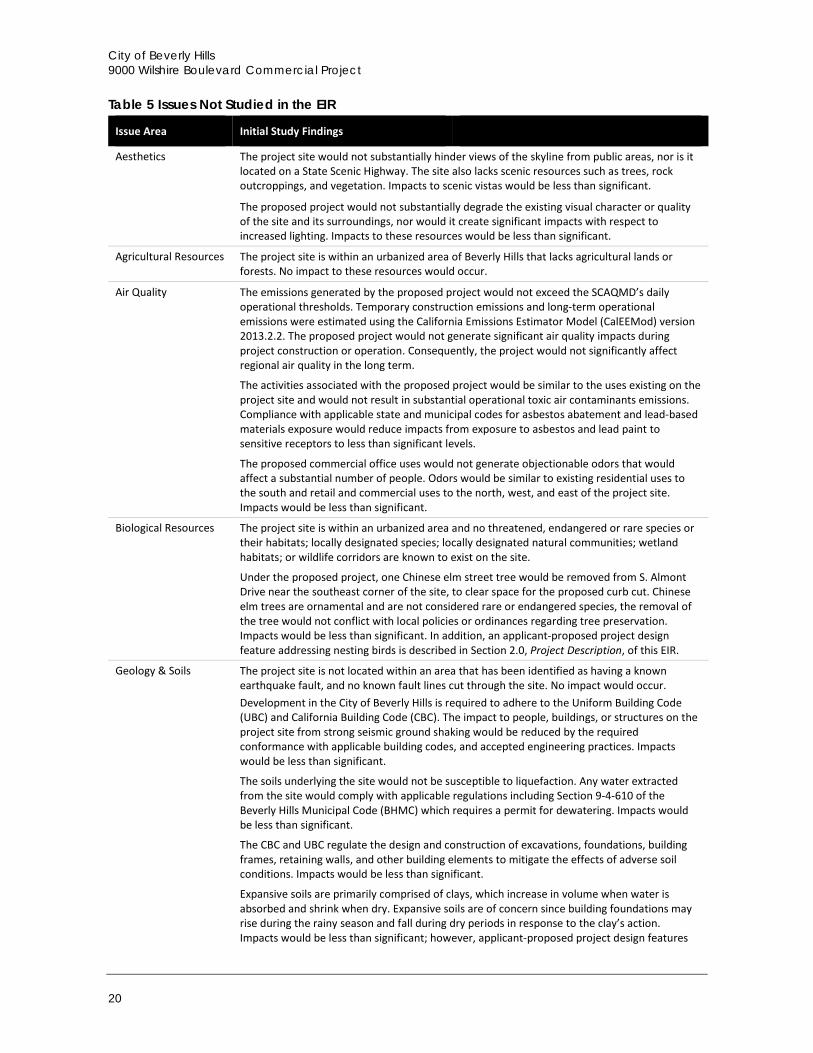
1.4 Issues Not Studied in Detail in the EIR Table 5 summarizes issues from the environmental checklist that were addressed in the Initial Study (Appendix B). As indicated in the Initial Study, there is no substantial evidence that significant impacts would occur in any of these issue areas.
City of Beverly Hills 9000 Wilshire Boulevard Commercial Project
20
Table 5 Issues Not Studied in the EIR
Issue Area Initial Study Findings
Aesthetics The project site would not substantially hinder views of the skyline from public areas, nor is it located on a State Scenic Highway. The site also lacks scenic resources such as trees, rock outcroppings, and vegetation. Impacts to scenic vistas would be less than significant.
The proposed project would not substantially degrade the existing visual character or quality of the site and its surroundings, nor would it create significant impacts with respect to increased lighting. Impacts to these resources would be less than significant.
Agricultural Resources The project site is within an urbanized area of Beverly Hills that lacks agricultural lands or forests. No impact to these resources would occur.
Air Quality The emissions generated by the proposed project would not exceed the SCAQMD’s daily operational thresholds. Temporary construction emissions and long-term operational emissions were estimated using the California Emissions Estimator Model (CalEEMod) version 2013.2.2. The proposed project would not generate significant air quality impacts during project construction or operation. Consequently, the project would not significantly affect regional air quality in the long term.
The activities associated with the proposed project would be similar to the uses existing on the project site and would not result in substantial operational toxic air contaminants emissions. Compliance with applicable state and municipal codes for asbestos abatement and lead-based materials exposure would reduce impacts from exposure to asbestos and lead paint to sensitive receptors to less than significant levels.
The proposed commercial office uses would not generate objectionable odors that would affect a substantial number of people. Odors would be similar to existing residential uses to the south and retail and commercial uses to the north, west, and east of the project site. Impacts would be less than significant.
Biological Resources The project site is within an urbanized area and no threatened, endangered or rare species or their habitats; locally designated species; locally designated natural communities; wetland habitats; or wildlife corridors are known to exist on the site.
Under the proposed project, one Chinese elm street tree would be removed from S. Almont Drive near the southeast corner of the site, to clear space for the proposed curb cut. Chinese elm trees are ornamental and are not considered rare or endangered species, the removal of the tree would not conflict with local policies or ordinances regarding tree preservation. Impacts would be less than significant. In addition, an applicant-proposed project design feature addressing nesting birds is described in Section 2.0, Project Description, of this EIR.
Geology & Soils The project site is not located within an area that has been identified as having a known earthquake fault, and no known fault lines cut through the site. No impact would occur. Development in the City of Beverly Hills is required to adhere to the Uniform Building Code (UBC) and California Building Code (CBC). The impact to people, buildings, or structures on the project site from strong seismic ground shaking would be reduced by the required conformance with applicable building codes, and accepted engineering practices. Impacts would be less than significant.
The soils underlying the site would not be susceptible to liquefaction. Any water extracted from the site would comply with applicable regulations including Section 9-4-610 of the Beverly Hills Municipal Code (BHMC) which requires a permit for dewatering. Impacts would be less than significant.
The CBC and UBC regulate the design and construction of excavations, foundations, building frames, retaining walls, and other building elements to mitigate the effects of adverse soil conditions. Impacts would be less than significant.
Expansive soils are primarily comprised of clays, which increase in volume when water is absorbed and shrink when dry. Expansive soils are of concern since building foundations may rise during the rainy season and fall during dry periods in response to the clay’s action. Impacts would be less than significant; however, applicant-proposed project design features
Introduction
Draft Environmental Impact Report 21
Issue Area Initial Study Findings
regarding construction methods and expansive soils are addressed in Section 2.0, Project Description, of this EIR.
The lack of elevation difference on the project site, the relatively flat surroundings, and the fact that the project site is not located within the landslide hazard zone on the City of Beverly Hills Seismic Hazards Map, result in no potential for landslides. Impacts would be less than significant.
The project does not include a septic system; therefore, there is no potential for adverse effects due to soil incompatibility. No impact would occur.
Greenhouse Gas Emissions
Greenhouse gas (GHG) emissions associated with the proposed project were estimated using CalEEMod. Based on output results from CalEEMod, the proposed project would not generate GHG emissions that would exceed thresholds. Impacts would be less than significant.
Hazards & Hazardous Materials
Local, state, and federal regulations and standards are in place to regulate the transportation, use, and disposal of hazardous materials. In addition, there are several local departments and agencies that are able to respond to foreseeable upset and accident conditions involving the release of hazardous materials into the environment. Impacts would be less than significant.
Any hazardous materials emitted by or involved with the proposed project would be regulated by federal, state, and local standards from OSHA, the State of California Occupational Safety and Health Administration, and the Beverly Hills Fire Department (BHFD). In addition, the project would not emit hazardous emissions or handle hazardous materials within one-quarter mile of a school. Impacts would be less than significant.
Three Leaking Underground Storage Tanks (LUSTs) were found within one mile of the project site. However, all LUSTs are designated as “case closed,” requiring no further assessment or cleanup. Therefore, no environmental issues are associated with the LUSTs. Other evidence of recognized hazardous environmental conditions such as above ground or below ground tanks, pits, ponds, significantly stained soil or asphalt/ concrete or stressed vegetation were not observed. Impacts would be less than significant.
The project site is located approximately five miles northeast of the Santa Monica Municipal Airport. The project site is not within an area covered by an airport land use plan, nor is it located in the vicinity of a private air strip. Impacts would be less than significant.
The applicant would be required to comply with all applicable City codes and regulations pertaining to emergency response and evacuation plans maintained by the police and fire departments in the City of Beverly Hills. Construction activities associated with the project do not include permanent or temporary street closures or changes in traffic flow. Impacts to emergency response plans or emergency evacuation plans would not occur.
The applicant would be required to provide proof of compliance with all applicable building and fire code requirements. Therefore, significant impacts to people or structures as a result of wildland fires would not occur.
Hydrology & Water Quality
Conformance with Section 402 of the Clean Water Act (CWA) and the BHMC would ensure that the proposed project does not violate any water quality standards or waste discharge requirements, substantially decrease groundwater, or interfere with groundwater recharge. Impacts would be less than significant.
Development under the proposed project would not result in a net deficit in aquifer volume or a lowering of the groundwater table. The project would not result in an exceedance of safe yield or a significant depletion of groundwater supplies. Impacts would be less than significant.
The applicant would be required to comply with the BHMC Section 9-4-506, which requires the implementation of BMPs. The BMPs applied during project construction would prevent sediment flow into a water source. These construction and erosion control practices would reduce the potential for adverse effects caused by excavation and general construction. The project site is nearly level. Development of the proposed project would not introduce new surface water discharges as there are already structures on the project site, would not substantially increase runoff volumes, and would not result in flooding on- or off-site. Impacts would be less than significant.
City of Beverly Hills 9000 Wilshire Boulevard Commercial Project
22
Issue Area Initial Study Findings
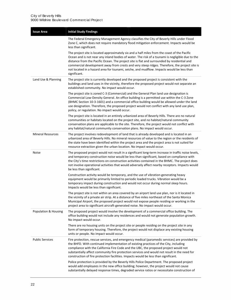
The Federal Emergency Management Agency classifies the City of Beverly Hills under Flood Zone C, which does not require mandatory flood mitigation enforcement. Impacts would be less than significant.
The project site is located approximately six and a half miles from the coast of the Pacific Ocean and is not near any inland bodies of water. The risk of a tsunami is negligible due to the distance from the Pacific Ocean. The project site is flat and surrounded by residential and commercial development away from crests and very steep ridges. Therefore, the project site is not located in a hazard area for tsunami, seiche, and mudflow. Impacts would be less than significant.
Land Use & Planning The project site is currently developed and the proposed project is consistent with the buildings and land uses in the vicinity, therefore the proposed project would not separate an established community. No impact would occur.
The project site is zoned C-3 (Commercial) and the General Plan land use designation is Commercial Low-Density General. An office building is a permitted use within the C-3 Zone (BHMC Section 10-3-1601) and a commercial office building would be allowed under the land use designation. Therefore, the proposed project would not conflict with any land use plan, policy, or regulation. No impact would occur.
The project site is located in an entirely urbanized area of Beverly Hills. There are no natural communities or habitats located on the project site, and no habitat/natural community conservation plans are applicable to the site. Therefore, the project would not conflict with any habitat/natural community conservation plans. No impact would occur.
Mineral Resources The project involves redevelopment of land that is already developed and is located in an urbanized area of Beverly Hills. No mineral resources of value to the region or the residents of the state have been identified within the project area and the project area is not suited for resource extraction given the urban location. No impact would occur.
Noise The proposed project would not result in a significant long-term increase in traffic noise levels, and temporary construction noise would be less than significant, based on compliance with the City’s time restrictions on construction activities contained in the BHMC. The project does not involve operational activities that would adversely affect nearby receptors. Impacts would be less than significant.
Construction activity would be temporary, and the use of vibration-generating heavy equipment would be primarily limited to periodic loaded trucks. Vibration would be a temporary impact during construction and would not occur during normal sleep hours. Impacts would be less than significant.
The project site is not within an area covered by an airport land use plan, nor is it located in the vicinity of a private air strip. At a distance of five miles northeast of the Santa Monica Municipal Airport, the proposed project would not expose people residing or working in the project area to significant aircraft-generated noise. No impact would occur.
Population & Housing The proposed project would involve the development of a commercial office building. The office building would not include any residences and would not generate population growth. No impact would occur.
There are no housing units on the project site or people residing on the project site in any form of temporary housing. Therefore, the project would not displace any existing housing units or people. No impact would occur.
Public Services
Fire protection, rescue services, and emergency medical (paramedic services) are provided by the BHFD. With continued implementation of existing practices of the City, including compliance with the California Fire Code and the UBC, the proposed project would not substantially affect community fire protection services and would not result in the need for construction of fire protection facilities. Impacts would be less than significant.
Police protection is provided by the Beverly Hills Police Department. The proposed project would add employees in the new office building; however, the project would not cause substantially delayed response times, degraded service ratios or necessitate construction of
Introduction
Draft Environmental Impact Report 23
Issue Area Initial Study Findings
new facilities, due to the site location within an already developed and well-served area with a low response time of 2.8 minutes. Impacts would be less than significant.
The project site is served by the Beverly Hills Unified School District. The proposed project would not involve any new residents, and therefore would not result in any additional students in the school district. There would be no impact.
The Beverly Hills Recreation and Parks Department is responsible for maintaining and planning for parkland in the City of Beverly Hills. The use of parks for recreational purposes is not typical for an office use, and the proposed project would include a rooftop lunchroom for building occupants. Therefore, impacts would be less than significant.
There are no public services or public facilities, such as libraries or hospitals, for which significant impacts are anticipated.
Recreation Use of parks for recreational purposes is not typical for an office use. In the event that employees would use parks, it would likely be for passive activities, such as meditation or relaxation, or as a space to eat lunch. The proposed project would include a rooftop lunchroom for building occupants. Therefore, due to the distance from parks and limited use of parks by project employees, impacts from the proposed project would be less than significant.
The project applicant would be required to pay the City’s Park and Recreation Facilities Construction Tax, pursuant to BHMC Section 3-1-703. The proposed project would not directly affect any existing or planned parks. Impacts would be less than significant.
Utilities
The Los Angeles Regional Water Quality Control Board (LARWQCB) stipulates standards and regulations for utility service providers such as the Los Angeles Hyperion Wastewater Treatment Plant (HTP). A substantial increase in wastewater diverted to the HTP could conflict with pollutant standards and regulations of the LARWQCB. The project would not exceed the wastewater limits of the HTP. Therefore, the plant would be able to adequately treat project-generated sewage in addition to existing sewage, and the treatment requirements of the LARWQCB would not be exceeded. Impacts would be less than significant.
The overall effect of the proposed project would be to ultimately reduce pollutants from the site that enter the storm drain system since the new development would be subject to current regulatory requirements, which are more stringent than regulations to which the existing onsite development was subject. Impacts would be less than significant.
There would be sufficient water supplies available to serve the project from existing entitlements and resources. No new or expanded entitlements would be needed to serve the proposed project. The proposed project would not result in a substantial physical deterioration of public water facilities. Impacts would be less than significant.
The proposed project would not result in an increase in solid waste beyond the capacity of the three designated landfills. Continued compliance with solid waste diversion requirements and the implementation of standard building regulations would be sufficient to address impacts related to solid waste generation. Impacts would be less than significant.
1.5 Lead, Responsible, and Trustee Agencies The CEQA Guidelines define lead, responsible and trustee agencies. The City of Beverly Hills is the lead agency for the project because it holds principal responsibility for approving the project.
A responsible agency refers to a public agency other than the lead agency that has discretionary approval over the project. Responsible agencies include the LARWQCB, which regulates water quality in the region, and the SCAQMD, which regulates air quality in the region. The SCAQMD submitted comments in the Initial Study, which is provided in Appendix B. The EIR will also be submitted to these agencies for review and comment.
City of Beverly Hills 9000 Wilshire Boulevard Commercial Project
24
A trustee agency refers to a state agency having jurisdiction by law over natural resources affected by a project. There are no trustee agencies for the proposed project.
1.6 Environmental Review Process The environmental impact review process, as required under CEQA, is summarized below and illustrated in Figure 1. The steps are presented in sequential order.
1 Notice of Preparation (NOP) and Initial Study. After deciding that an EIR is required, the lead agency (City of Beverly Hills) must file a NOP soliciting input on the EIR scope to the State Clearinghouse, other concerned agencies, and parties previously requesting notice in writing (CEQA Guidelines Section 15082; Public Resources Code Section 21092.2). The NOP must be posted in the County Clerk’s office for 30 days. The NOP may be accompanied by an Initial Study that identifies the issue areas for which the project could create significant environmental impacts.
2 Draft EIR Prepared. The Draft EIR must contain: a) table of contents or index; b) summary; c) project description; d) environmental setting; e) discussion of significant impacts (direct, indirect, cumulative, growth-inducing and unavoidable impacts); f) a discussion of alternatives; g) mitigation measures; and h) discussion of irreversible changes.
3 Notice of Completion (NOC). The lead agency must file a NOC with the State Clearinghouse when it completes a Draft EIR and prepare a Public Notice of Availability of a Draft EIR. The lead agency must place the NOC in the County Clerk’s office for 30 days (Public Resources Code Section 21092) and send a copy of the NOC to anyone requesting it (CEQA Guidelines Section 15087). Additionally, public notice of Draft EIR availability must be given through at least one of the following procedures: a) publication in a newspaper of general circulation; b) posting on and off the project site; and c) direct mailing to owners and occupants of contiguous properties. The lead agency must solicit input from other agencies and the public, and respond in writing to all comments received (Public Resources Code Sections 21104 and 21253). The minimum public review period for a Draft EIR is 30 days. When a Draft EIR is sent to the State Clearinghouse for review, the public review period must be 45 days unless the State Clearinghouse approves a shorter period (Public Resources Code 21091).
4 Final EIR. A Final EIR must include: a) the Draft EIR; b) copies of comments received during public review; c) list of persons and entities commenting; and d) responses to comments.
5 Certification of Final EIR. Prior to making a decision on a proposed project, the lead agency must certify that: a) the Final EIR has been completed in compliance with CEQA; b) the Final EIR was presented to the decision-making body of the lead agency; and c) the decision making body reviewed and considered the information in the Final EIR prior to approving a project (CEQA Guidelines Section 15090).
6 Lead Agency Project Decision. The lead agency may a) disapprove the project because of its significant environmental effects; b) require changes to the project to reduce or avoid significant environmental effects; or c) approve the project despite its significant environmental effects, if the proper findings and statement of overriding considerations are adopted (CEQA Guidelines Sections 15042 and 15043).
7 Findings/Statement of Overriding Considerations. For each significant impact of the project identified in the EIR, the lead agency must find, based on substantial evidence, that either: a) the project has been changed to avoid or substantially reduce the magnitude of the impact; b) changes to the project are within another agency's jurisdiction and such changes have or should be adopted; or c) specific economic, social, or other considerations make the mitigation measures or project alternatives infeasible (CEQA Guidelines Section 15091). If an agency approves a project with unavoidable significant environmental effects, it must prepare a written Statement of Overriding Considerations that sets forth the specific social, economic, or other reasons supporting the agency’s decision.
Introduction
Draft Environmental Impact Report 25
Figure 1 Environmental Review Process
City of Beverly Hills 9000 Wilshire Boulevard Commercial Project
26
8 Mitigation Monitoring Reporting Program. When the lead agency makes findings on significant effects identified in the EIR, it must adopt a reporting or monitoring program for mitigation measures that were adopted or made conditions of project approval to mitigate significant effects.
9 Notice of Determination (NOD). The lead agency must file a NOD after deciding to approve a project for which an EIR is prepared (CEQA Guidelines Section 15094). A local agency must file the NOD with the County Clerk. The NOD must be posted for 30 days and sent to anyone previously requesting notice. Posting of the NOD starts a 30 day statute of limitations on CEQA legal challenges (Public Resources Code Section 21167[c]).
Project Description
Draft Environmental Impact Report 27
2 Project Description
This section describes the proposed project, including the project applicant, the project site and surrounding land uses, major project characteristics, project objectives, and discretionary actions needed for approval.
2.1 Project Applicant 9000 Wilshire LLC 1805 Colorado Avenue Santa Monica, CA 90404 (310) 447-3000
2.2 Lead Agency Contact Person Masa Alkire, AICP, Principal Planner City of Beverly Hills Community Development Department 455 North Rexford Drive, First Floor Beverly Hills, CA 90210 (310) 285-1135
2.3 Project Location The project site is located at 9000-9010 Wilshire Boulevard on the southwest corner at the intersection of Wilshire Boulevard and S. Almont Drive in the City of Beverly Hills. The project site is relatively flat and rectangular with an area of 15,876 square feet (0.36 acres). The project site is denoted by Assessor Parcel Numbers 4331-028-003 and 4331-028-004. The site is currently developed with a one-story retail building and a two-story retail building on the northern portion of the site. These two buildings cover an area (building footprint) of 6,832 square feet, approximately 44 percent of the project site. A paved parking lot approximately 5,500 square feet in size is located behind the buildings, adjacent to the alley along the southern boundary of the project site. The buildings are served by an existing access drive on S. Almont Drive and via the alley at the rear of the site. The site is regionally accessible from the San Diego Freeway (Interstate 405, or I-405) and the Santa Monica Freeway (Interstate 10, or I-10), and locally accessible from Santa Monica Boulevard (State Route 2) and Wilshire Boulevard. Figure 2 shows the regional location of the project site and Figure 3 shows the location of the site in its neighborhood context. The site is in an urban area, has been previously graded and developed, and is surrounded by roads and urban structures (office buildings, residential buildings, and commercial buildings).
City of Beverly Hills 9000 Wilshire Boulevard Commercial Project
28
Figure 2 Regional Location
Project Description
Draft Environmental Impact Report 29
Figure 3 Project Site Location
City of Beverly Hills 9000 Wilshire Boulevard Commercial Project
30
2.4 Existing Site Characteristics
2.4.1 Current Land Use Designation and Zoning The project site is currently developed with a one-story retail building located at 9006-9010 Wilshire Boulevard and a two-story retail building located at 9000 Wilshire Boulevard. The two-story building is currently occupied by an antique/art shop, and the one-story building consists of three retail spaces that are occupied by a café, vape shop/lounge, and an insurance office. The project site has a General Plan land use designation of Commercial Low-Density General. The site is zoned C-3 (Commercial), as defined by the City’s Zoning Ordinance and the Land Use Element of the General Plan. Uses permitted in the C-3 Commercial Zone include a wide range of low- to high-intensity commercial uses, such as cafes, offices, and retail shops. The proposed project would not require amendments to the City’s General Plan or the BHMC.
2.4.2 Surrounding Land Uses The project site is bordered by a commercial development to the west, S. Almont Drive to the east, Wilshire Boulevard to the north, and an alley to the south. There is a six-story retail and office building immediately to the west of the project site, a three-story office building to the east across S. Almont Drive, a three-story office building to the north across Wilshire Boulevard, and a single-family home to the south of the alley.
2.5 Project Characteristics The project site is comprised of two lots located on the southwest corner at the intersection of Wilshire Boulevard and S. Almont Drive. The proposed project would involve demolition of current buildings and construction of a commercial office building.
The proposed project would involve demolition of the existing commercial buildings and the removal of the paved parking lot. The two-story building on the east side of the site is currently occupied by an antique/art shop, and the one-story building on the west side of the site consists of three retail spaces that are occupied by a café, vape shop/lounge, and an insurance office. After demolition, a new commercial office development with a 14,558 square-foot building footprint would be constructed, which would consist of three stories of commercial office development and four levels of subterranean parking. The project would also include a rooftop lunchroom, drought-tolerant landscape, bike storage, and a total of 91 parking spaces for occupants.
2.5.1 Proposed Site Plan Figures 4a through 4f show proposed site plans, including subterranean parking plans, office level plans, and rooftop plans. Figure 5 shows photographs of the existing buildings on the project site that would be demolished to accommodate the proposed project, and Figure 6 shows renderings of the proposed project. Table 6 shows the characteristics of the proposed commercial office building.
City of Beverly Hills 9000 Wilshire Boulevard Commercial Project
32
Figure 4b Office Plan Level 1
Project Description
Draft Environmental Impact Report 33
Figure 4c Office Plan Level 2
City of Beverly Hills 9000 Wilshire Boulevard Commercial Project
34
Figure 4d Office Plan Level 3
Project Description
Draft Environmental Impact Report 35
Figure 4e Office Plan Lunchroom Level
City of Beverly Hills 9000 Wilshire Boulevard Commercial Project
36
Figure 4f Rooftop Plan
Project Description
Draft Environmental Impact Report 37
Figure 5 Site Photographs
City of Beverly Hills 9000 Wilshire Boulevard Commercial Project
38
Figure 6 Project Renderings
Project Description
Draft Environmental Impact Report 39
Table 6 Project Characteristics
Address 9000-9010 Wilshire Boulevard
APN 4331-028-003 & 4331-028-004
Height/Stories 45 feet + 15 feet for rooftop lunchroom1
3 stories above grade, plus rooftop lunchroom and terrace eating area 4 stories below grade for basement parking
Lot Area 15,876 square feet (sf)
Building Footprint Approx. 14,558 sf
Total Floor Area 31,702 sf2
Parking Level 4 6,091 sf
Parking Level 3 14,101 sf
Parking Level 2 14,101 sf
Parking Level 1 13,154 sf
Ground Floor 8,006 sf
2nd Floor 11,348 sf
3rd Floor 12,348 sf
Rooftop Lunchroom 2,049 sf
Land Uses:
Commercial Office (Ground, 2nd, 3rd Floors) 31,702 sf
Rooftop Lunchroom 2,049 sf
Below-Grade Parking (Levels 1-4) 47,447 sf 1 Rooftop penthouse structures, including lunchroom and eating area, in accordance with BHMC §10-3-3107 are exempt from the height restrictions given that additional height does not exceed 15 feet 2 The total floor area is calculated pursuant to BHMC §10-3-100 and does not include parking areas, elevator shafts, stair shafts, rooms housing building operating equipment or machinery rooms, rooftop lunchrooms, or areas outside the surrounding walls of a building or structure. Total floor area is the sum of the ground, 2nd and 3rd floors.
sf = square feet
The 14,558 square-foot building footprint would occupy approximately 92 percent of the 15,876 square-foot lot. The proposed building would have a total floor area of 31,702 square feet of commercial space (not including parking areas, elevator and stair shafts, mechanical rooms housing operating equipment or machinery) and a 2,049 square-foot rooftop lunchroom for building occupants only. Outdoor patios would be provided on the second floor and roof. The proposed building would also include 47,447 square feet of parking area in four subterranean levels. The proposed building would have a height of 45 feet to the top of the roof. The proposed rooftop penthouse structures, including a lunchroom, terrace eating area, and painted steel brise soleil (perforated screen to filter sunlight), would extend an additional 15 feet from the top of the roof. Architecturally, the building would be characterized by clear glass curtain walls with dark metal panels between floors and at the rooftop parapet. A green wall planting with climbing vegetation at the outdoor terrace on the second floor would serve as an accent, visible from street level at Wilshire Boulevard.
Table 7 compares existing conditions to the proposed project with respect to building footprint and height.
City of Beverly Hills 9000 Wilshire Boulevard Commercial Project
40
Table 7 Summary of Proposed Changes Existing Development Proposed Project Change
Building Footprint 9000 Wilshire Blvd: 3,825 sf 9006-9010 Wilshire Blvd: 3,007 sf Total: 6,832 sf
Parking 9000-9010 Wilshire Blvd: 20 spaces 91 spaces +71 spaces 1 Rooftop penthouse structures, including lunchroom and eating area, in accordance with BHMC §10-3-3107 are exempt from the height restrictions given that additional height does not exceed 15 feet.
Drought-tolerant landscape would be integrated throughout the building. Ornamental grasses, shrubs, and herbaceous plants would border the rooftop lunch terrace and second floor terrace area. Bamboo would be planted as a screen for the rooftop lunch terrace, second floor terrace area, and the southwest corner of ground floor. A green wall planting with climbing vines would be planted on the second floor terrace area, against the building to the west of the site. A large privacy screen of juniper trees, eventually reaching a height of 15-30 feet at maturity, would be planted at the southern edge of the project site. One Chinese elm street tree would be removed from S. Almont Drive near the southeast corner of the site to clear space for the proposed curb cut.
2.5.2 Parking and Site Access The proposed project would include four levels of subterranean parking, with 91 parking spaces with a total area of 47,447 square feet. Four spaces would be accessible to persons with disabilities and eleven racks would be installed for bicycle parking. Vehicular access to the project would be provided from S. Almont Drive and the rear alley. Pedestrians would access the proposed building from double-door entrances on Wilshire Boulevard and S. Almont Drive and an egress door at the northwest corner of the building on Wilshire Boulevard.
The existing curb cut on S. Almont Drive would be removed and a new one would be constructed at the southeast edge of the site. This approximately 42-foot-wide curb cut would serve as an entry/exit point for a 22-foot-wide driveway leading to the underground parking garage and the exit to an adjacent 12-foot, 6-inch-wide loading dock. Vehicles would enter the loading dock via the alley. A 2-foot, 6-inch strip along the southern boundary of the project site would be set aside as a dedication for the alley.
2.5.3 Utilities The City of Beverly Hills Public Works Department provides the following utility services: solid waste, water, wastewater, and stormwater. Southern California Edison supplies electricity and the Southern California Gas Company provides gas to the City of Beverly Hills.
2.5.4 Construction and Grading Construction of the proposed project is expected to occur over approximately 18 months. Construction activities would be separated into four phases. The first phase would include initial site preparation and demolition of existing buildings; the second phase would include shoring and mass excavation; and the third phase would include construction of the subterranean parking and proposed building, glazing system installation, and roofing. During the second phase, the maximum depth of excavation would be approximately 44 feet and the total amount of exported soil associated with excavation would be approximately 25,872 cubic yards. The fourth construction phase would involve core and shell buildout,
Project Description
Draft Environmental Impact Report 41
which would include the elevator installation. Construction equipment for the project would include earthwork equipment such as drills for shoring, crane, concrete pump, and miscellaneous small tools.
2.5.5 Green Building Features The proposed project’s overall design would meet Leadership in Energy and Environmental Design (LEED) Gold or equivalent standards, which would be achieved by using less water and energy and reducing greenhouse gas emissions compared to a non-certified LEED commercial building. A building can earn credits toward LEED certification through performance in five key areas including sustainable sites, water savings, energy and atmosphere, materials and resources, and indoor environmental quality. The sixth category, innovation and design process, awards points for exceeding the minimum criteria in the first five categories (LEED, 2016). Solar panels and water conservation elements would be incorporated into the project design to reduce the building’s energy utilization and achieve LEED certification. Half of the roof would contain solar panels to capture solar energy.
2.5.6 Applicant-Proposed Project Design Features (PDFs) The following are project design features (PDFs) proposed by the applicant which would reduce or negate impacts concerning nesting birds and expansive soils. The City of Beverly Hills General Plan, Chapter 5 (Open Space), contains policies intended to protect, enhance and expand open space resources, remaining natural areas, and significant wildlife and vegetation in the City (Goal OS 1) including nesting birds. Implementation of Biological PDF 1, intended to be applied to the project permit conditions of approval for consistency with the City’s General Plan, would ensure no impacts would occur to nesting birds and consistency with the City of Beverly Hills General Plan (Goal OS 1 and Policy OS 1.1), the California Department of Fish and Game (CDFG) Code, and the Migratory Bird Treaty Act. Biological PDF 1 ensures consistency with General Plan Goal OS 1 by requiring protection for nesting birds within the City.
Biological PDF 1 – Avoid Bird Nesting Season or Conduct a Nesting Bird Survey and Provide Buffers. Vegetation removal and initial ground disturbance must occur either:
a) Outside the bird and raptor breeding season, which is typically January 1 through August 31, or
b) If vegetation clearing occurs during the breeding season, one pre-construction bird nesting survey shall be conducted not more than one week prior to vegetation clearing to determine the locations of nesting birds. The bird survey shall be conducted by a qualified biologist. If a nesting bird or special status species is located, consultation with the local California Department of Fish and Wildlife (CDFW) representative shall occur to determine what avoidance actions may be taken. Generally, if an active bird nest is found, a minimum 100-foot buffer (or as otherwise directed by CDFW) would be established surrounding the nest(s), which shall be flagged for avoidance. The results of the nesting bird survey(s) and any buffer efforts as a result of those surveys shall be documented in a brief letter report and submitted to the City and the CDFW prior to commencement of clearing.
The applicant is proposing implementation of Geological PDF 1 and Geological PDF 2 from the Geotechnical Engineering Investigation [for the] Proposed Commercial Office Building, 9000 Wilshire Boulevard, Beverly Hills, California to ensure that the proposed building would not be affected by expansive soils.
Geological PDF 1 – Foundation Design. Due to the depth of the proposed subterranean levels relative to the historically highest groundwater level, the proposed structure shall be designed to resist hydrostatic and uplift pressures based on the historically highest groundwater level. Therefore the proposed structure shall be supported on a mat foundation bearing on the underlying native soils, at the lowest level of the subterranean parking garage. An allowable bearing pressure of 5,000
City of Beverly Hills 9000 Wilshire Boulevard Commercial Project
42
pounds per square foot shall be utilized in the design of the proposed mat foundation. The mat foundation shall be designed utilizing a modulus of subgrade reaction of 200 kips per cubic foot. The thickness of the mat foundation shall be designed by the project structural engineer. The bottom of the mat foundation shall be a minimum of 18 inches in depth below the lowest adjacent grade at the perimeter of the structure. Proper waterproofing shall be provided below the base of the mat and a waterproofing consultant shall be retained in order to recommend appropriate products and methods to waterproof below the mat.
Where necessary, uplift anchors may be designed to provide resistance against the anticipated hydrostatic uplift pressures acting on the mat foundations. Uplift anchors shall be a minimum of 12 inches in diameter, and shall be embedded a minimum of 20 feet into the underlying native soils. Uplift anchors shall be designed using a frictional capacity of at least 1.5 kips per lineal foot.
Geological PDF 2 – Concrete Slabs-on-Grade. Slabs-on-grade shall be cast over undisturbed native soils or properly compacted fill materials. Any geologic materials loosened or over-excavated shall be wasted from the site or properly compacted to 90 percent of the maximum dry density. Outdoor concrete flatwork shall be a minimum of 4 inches in thickness and shall be cast over undisturbed native soils or properly compacted fill material.
2.6 Project Objectives Promote economic sustainability by attracting prominent firms in key business sectors that contribute to the City’s identity, culture, and economy, provide high-paying jobs, and generate revenue for the City. Such businesses include entertainment-related and other high-profile firms that seek Class-A creative office buildings. Build to a standard considered Class-A office, which includes features such as high-quality architectural design and building materials, prominent placement of the building on the site, and floor plates that accommodate Class-A office users and allow efficient use of the space. Design a commercial building located adjacent to a residential neighborhood that ensures the integrity and quality of both the commercial and residential neighborhoods. Design and construct a project in accordance with the City’s Green Building Ordinance that incorporates energy, water, and natural resource conservation features and a construction program that minimizes waste and the use of toxic and hazardous materials.
2.7 Required Approvals The proposed project would require a demolition and building permit. In addition, a discretionary permit/entitlement for Development Plan Review of a new building and a rooftop lunchroom would be required.
Environmental Setting
Draft Environmental Impact Report 43
3 Environmental Setting
This section provides a general overview of the environmental setting for the proposed project. More detailed descriptions of the environmental setting for each environmental issue area can be found in Section 4.0, Environmental Impact Analysis.
3.1 Regional Setting The project site is located in the City of Beverly Hills, approximately nine miles west of the civic center of the City of Los Angeles. It is located on the southwest corner of the intersection of Wilshire Boulevard and S. Almont Drive. The approximately 16,000-square foot site is currently occupied by two retail buildings on the northern portion of the project site. Figure 2 in Section 2.0, Project Description, shows the location of the project site in the region. Figure 3 shows the location of the project site in relationship to the surrounding neighborhood.
A grid system of east-west and north-south roadways, including arterials, collectors, and local streets, provide vehicular access throughout the City. The major roadways include Santa Monica Boulevard, Wilshire Boulevard, Sunset Boulevard, Whittier Drive, and Beverly Drive. The closest freeways are Interstate 405 (I-405) and Interstate 10 (I-10). I-405 is located over two miles west of the project site, and I-10 is located over two miles south of the Project site.
The Mediterranean climate of the region and the coastal influence produce moderate temperatures year round, with rainfall concentrated in the winter months. Although air quality in the area has steadily improved in recent years, the Los Angeles region remains a nonattainment area for ozone (urban smog). The City of Beverly Hills is located approximately seven miles inland from the coastline of the Pacific Ocean.
3.2 Project Site Setting As shown in Figure 3 in Section 2.0, Project Description, the project site is bordered by a commercial development to the west, S. Almont Drive to the east, Wilshire Boulevard to the north, and an alley to the south. There is a six-story retail and office building immediately to the west of the project site, a three-story office building to the east across S. Almont Drive, a three-story office building to the north across Wilshire Boulevard, and a single-family home to the south of the alley.
The project site is currently occupied by two commercial buildings and has a General Plan land use designation of Commercial Low-Density General. The site is zoned C-3 (Commercial), as defined by the City’s Zoning Ordinance and the Land Use Element of the General Plan. Uses permitted in the C-3 designation include a wide range of low- to high-intensity commercial uses, such as cafes, retail shops, and office buildings.
3.3 Cumulative Development In addition to the specific impacts of individual projects, CEQA requires EIRs to consider potential cumulative impacts of the proposed project. CEQA defines “cumulative impacts” as two or more individual impacts that, when considered together, are substantial or will compound other environmental impacts. Cumulative impacts are the combined changes in the environment that result
City of Beverly Hills 9000 Wilshire Boulevard Commercial Project
44
from the incremental impact of development of the proposed project and other nearby projects. For example, traffic impacts of two nearby projects may be less than significant when analyzed separately, but could have a significant impact when analyzed together. Cumulative impact analysis allows the EIR to provide a reasonable forecast of future environmental conditions and can more accurately gauge the effects of a series of projects.
CEQA requires cumulative impact analysis in EIRs to consider either a list of planned and pending projects that may contribute to cumulative effects or a forecast of future development potential. Currently planned and pending projects in Beverly Hills and surrounding areas, including the City of Los Angeles and the City of West Hollywood, are listed in Table 8. In particular, the 154-168 N. La Peer Drive Project, 8600 Wilshire Boulevard Project, 8769 Wilshire Boulevard Project, 9200 Wilshire Boulevard Project, 9230 Wilshire Boulevard Project, and the 9876 Wilshire Boulevard Project are either located in close proximity or along the same major arterial as the project site and construction schedules may overlap. These projects are considered in the cumulative analyses in Section 4.0, Environmental Impact Analysis.
Table 8 Cumulative Projects List
Project No. Project Location1 Land Use
City of Beverly Hills
1 257 N. Canon Drive Commercial
2 246 N. Canon Drive Restaurant
3 9262 Burton Way Condominiums
4 325 N. Maple Drive Office
5 450-60 N. Palm Drive Condominiums
6 154-168 N. La Peer Drive Condominiums
7 425 N. Palm Drive Condominiums
8 432 N. Oakhurst Drive Condominiums
9 8955 W. Olympic Boulevard Auto Sales
10 332 N. Oakhurst Drive Condominiums
11 121 San Vicente Boulevard Medical Office
12 207 S. Robertson Boulevard Office
13 8600 Wilshire Boulevard Mixed-Use
14 8767 Wilshire Boulevard Mixed-Use
15 9200 Wilshire Boulevard Mixed-Use
16 305-239 S. Elm Drive Condominiums
17 9876 Wilshire Boulevard Mixed-Use
18 9230 Wilshire Boulevard Auto Sales
Environmental Setting
Draft Environmental Impact Report 45
Project No. Project Location1 Land Use
City of West Hollywood
19 8816 Beverly Boulevard Mixed-Use
20 612 Croft Avenue Condominiums
21 8451 Melrose Avenue Retail
22 8551 Melrose Avenue Retail
23 8564 Melrose Avenue Retail/Commercial
24 8583 Melrose Avenue Retail/Commercial
25 8650 Melrose Avenue Mixed-Use
26 8711 Melrose Avenue Commercial
27 8715 Melrose Avenue Mixed-Use
28 507 Orlando Avenue Apartments
29 9001 Santa Monica Boulevard Mixed-Use
30 9040-9098 Santa Monica Boulevard Mixed-Use
31 645-681 N. Robertson Boulevard Mixed-Use
City of Los Angeles
32 300 S. Wetherly Drive Condominiums
33 6535 Wilshire Boulevard Mixed-Use
34 8723 W. Alden Drive Medical Building
35 316 N. La Cienega Boulevard Mixed-Use
36 9786 W. Pico Boulevard Cultural Space
37 1022 S. La Cienega Boulevard Assisted Living
38 100 N. La Cienega Boulevard Commercial
39 9760 W. Pico Boulevard High School
40 375 N. La Cienega Boulevard Mixed-Use
41 1055 La Cienega Boulevard Day School
42 333 S. La Cienega Boulevard Mixed-Use
1 Cumulative project details were sourced from the Traffic Impact Study prepared for the project by KOA Corporation, in December 2015 (see Appendix D-1 of this EIR).
City of Beverly Hills 9000 Wilshire Boulevard Commercial Project
46
This page left intentionally blank.
Environmental Impact Analysis
Draft Environmental Impact Report 47
4 Environmental Impact Analysis
This section discusses the possible environmental effects of the 9000 Wilshire Boulevard Commercial Project for the specific issue areas that were identified through the scoping process as having the potential to experience significant effects. “Significant effect” is defined by the CEQA Guidelines §15382 as:
“…a substantial, or potentially substantial, adverse change in any of the physical conditions within the area affected by the project including land, air, water, minerals, flora, fauna, ambient noise, and objects of historic or aesthetic significance. An economic or social change by itself shall not be considered a significant effect on the environment, but may be considered in determining whether the physical change is significant.”
The assessment of each issue area begins with a discussion of the environmental setting related to the issue, which is followed by the impact analysis. In the impact analysis, the first subsection identifies the methodologies used and the “significance thresholds,” which are those criteria adopted by the City and other agencies, universally recognized, or developed specifically for this analysis to determine whether potential effects are significant. The next subsection describes each impact of the proposed project, mitigation measures for significant impacts, and the level of significance after mitigation. Each effect under consideration for an issue area is separately listed in bold text with the discussion of the effect and its significance. Each bolded impact statement also contains a statement of the significance determination for the environmental impact as follows:
Significant and Unavoidable: An impact that cannot be reduced to below the threshold level given reasonably available and feasible mitigation measures. Such an impact requires a Statement of Overriding Considerations to be issued if the project is approved per §15093 of the CEQA Guidelines.
Less than Significant with Mitigation Incorporated: An impact that can be reduced to below the threshold level given reasonably available and feasible mitigation measures. Such an impact requires findings under §15091 of the CEQA Guidelines.
Less than Significant: An impact that may be adverse, but does not exceed the threshold levels and does not require mitigation measures. However, mitigation measures that could further lessen the environmental effect may be suggested if readily available and easily achievable.
No Impact The proposed project would have no effect on environmental conditions or would reduce existing environmental problems or hazards.
Following each environmental impact discussion is a list of mitigation measures (if required) and the residual effects or level of significance remaining after implementation of the measure(s). In cases where the mitigation measure for an impact could have a significant environmental impact in another issue area, this impact is discussed and evaluated as a secondary impact. The impact analysis concludes with a discussion of cumulative effects, which evaluates the impacts associated with the proposed project in conjunction with other planned and pending developments in the area listed in Section 3.0, Environmental Setting.
The Executive Summary of this EIR summarizes all impacts and mitigation measures that apply to the proposed project.
City of Beverly Hills 9000 Wilshire Boulevard Commercial Project
48
This page left intentionally blank.
Environmental Impact Analysis Cultural and Tribal Resources
Draft Environmental Impact Report 49
4.1 Cultural and Tribal Resources This section assesses potential impacts to cultural resources from the proposed project. Rincon Consultants, Inc. (Rincon) conducted a cultural resources assessment for the project which included a records search at the South Central Coastal Information Center (SCCIC), a survey of the project area, archival research, a historic evaluation and preparation of a historic assessment report. The Cultural Resources Assessment documents the historic resources on the project site. The information below is derived from the Cultural Resources Assessment, which is included as Appendix C of this EIR.
4.1.1 Setting a. Regulatory Setting
This section includes a discussion of the applicable federal, state, and local laws, ordinances, regulations, and standards governing cultural resources, which must be adhered to before and during implementation of the proposed project.
National Register of Historic Places. The National Register of Historic Places (NRHP) was established by the National Historic Preservation Act (NHPA) of 1966 as “an authoritative guide to be used by federal, State, and local governments, private groups and citizens to identify the Nation’s cultural resources and to indicate what properties should be considered for protection from destruction or impairment" (CFR 36 CFR 60.2). The NRHP recognizes properties that are significant at the national, state, and local levels. To be eligible for listing in the NRHP, a resource must be significant in American history, architecture, archaeology, engineering, or culture. Districts, sites, buildings, structures, and objects of potential significance must also possess integrity of location, design, setting, materials, workmanship, feeling, and association. A property is eligible for the NRHP if it is significant under one or more of the following criteria:
Criterion A: It is associated with events that have made a significant contribution to the broad patterns of our history;
Criterion B: It is associated with the lives of persons who are significant in our past;
Criterion C: It embodies the distinctive characteristics of a type, period, or method of construction, or represents the work of a master, or possesses high artistic values, or represents a significant and distinguishable entity whose components may lack individual distinction; and/or
Criterion D: It has yielded, or may be likely to yield, information important in prehistory or history.
California Register of Historical Resources. CEQA (Section 21084.1) requires a lead agency determine whether a project could have a significant effect on historical resources and tribal cultural resources (PRC Section 21074 [a][1][A]-[B]). A historical resource is a resource listed in or determined to be eligible for listing in the California Register of Historical Resources (CRHR) (Section 21084.1), a resource included in a local register of historical resources (Section 15064.5[a][2]), or any object, building, structure, site, area, place, record, or manuscript that a lead agency determines to be historically significant (Section 15064.5[a][3]).
PRC Section 5024.1, Section 15064.5 of the CEQA Guidelines, and PRC Sections 21083.2 and 21084.1 were used as the basic guidelines for this cultural resources study. PRC Section 5024.1 requires an evaluation of historical resources to determine their eligibility for listing in the CRHR. The purpose of the register is to maintain listings of the state’s historical resources and to indicate which properties are to be protected from substantial adverse change. The criteria for listing resources in the CRHR were
City of Beverly Hills 9000 Wilshire Boulevard Commercial Project
50
expressly developed to be in accordance with previously established criteria developed for listing in the NRHP, as enumerated according to CEQA below.
(3) […] Generally, a resource shall be considered by the lead agency to be ”historically significant” if the resource meets the criteria for listing on the California Register of Historical Resources (Pub. Res. Code, § 5024.1, Title 14 CCR, Section 4852) including the following:
(1) Is associated with events that have made a significant contribution to the broad patterns of California's history and cultural heritage;
(2) Is associated with the lives of persons important in our past;
(3) Embodies the distinctive characteristics of a type, period, region, or method of construction, or represents the work of an important creative individual, or possesses high artistic values; or
(4) Has yielded, or may be likely to yield, information important in prehistory or history.
(4) The fact that a resource is not listed in, or determined to be eligible for listing in the California Register of Historical Resources, not included in a local register of historical resources (pursuant to section 5020.1(k) of the Public Resources Code), or identified in an historical resources survey (meeting the criteria in section 5024.1(g) of the Public Resources Code) does not preclude a lead agency from determining that the resource may be an historical resource as defined in Public Resources Code sections 5020.1(j) or 5024.1.
(b) A project with an effect that may cause a substantial adverse change in the significance of an historical resource is a project that may have a significant effect on the environment.
In addition, if a project can be demonstrated to cause damage to a unique archaeological resource, the lead agency may require reasonable efforts to permit any or all of these resources to be preserved in place or left in an undisturbed state. To the extent that resources cannot be left undisturbed, mitigation measures are required (PRC, Section 21083.2[a], [b], and [c]).
PRC, Section 21083.2(g) defines a unique archaeological resource as an artifact, object, or site about which it can be clearly demonstrated that, without merely adding to the current body of knowledge, there is a high probability that it:
1. Contains information needed to answer important scientific research questions and that there is a demonstrable public interest in that information;
2. Has a special and particular quality such as being the oldest of its type or the best available example of its type; or
3. Is directly associated with a scientifically recognized important prehistoric or historic event or person.
Impacts to significant cultural resources that affect the characteristics of any resource that qualify it for the NRHP or adversely alter the significance of a resource listed in or eligible for listing in the CRHR are considered a significant effect on the environment. These impacts could result from physical demolition, destruction, relocation, or alteration of the resource or its immediate surroundings such that the significance of an historical resource would be materially impaired (CEQA Guidelines, Section 15064.5 [b][1], 2000). Material impairment is defined as demolition or alteration in an adverse manner [of] those characteristics of an historical resource that convey its historical significance and that justify its inclusion in, or eligibility for inclusion in, the CRHR (CEQA Guidelines, Section 15064.5[b][2][A]).
Environmental Impact Analysis Cultural and Tribal Resources
Draft Environmental Impact Report 51
Assembly Bill 52. As of July 1, 2015, California Assembly Bill 52 of 2014 (AB 52) was enacted and expands CEQA by defining a new resource category, “tribal cultural resources.” Assembly Bill 52 establishes that “A project with an effect that may cause a substantial adverse change in the significance of a tribal cultural resource is a project that may have a significant effect on the environment” (PRC Section 21084.2). It further states that the lead agency shall establish measures to avoid impacts that would alter the significant characteristics of a tribal cultural resource, when feasible (PRC Section 21084.3). PRC Section 21074 (a)(1)(A) and (B) defines tribal cultural resources as “sites, features, places, cultural landscapes, sacred places, and objects with cultural value to a California Native American tribe” and meets either of the following criteria:
a) Listed or eligible for listing in the California Register of Historical Resources, or in a local register of historical resources as defined in Public Resources Code section 5020.1(k), or
b) A resource determined by the lead agency, in its discretion and supported by substantial evidence, to be significant pursuant to criteria set forth in subdivision (c) of Public Resources Code Section 5024.1. In applying the criteria set forth in subdivision (c) of Public Resource Code Section 5024.1, the lead agency shall consider the significance of the resource to a California Native American tribe.
In recognition of California Native American tribal sovereignty and the unique relationship of California local governments and public agencies with California Native American tribal governments, and respecting the interests and roles of project proponents, it is the intent AB 52 to accomplish all of the following:
(1) Recognize that California Native American prehistoric, historic, archaeological, cultural, and sacred places are essential elements in tribal cultural traditions, heritages, and identities.
(2) Establish a new category of resources in CEQA called “tribal cultural resources” that considers the tribal cultural values in addition to the scientific and archaeological values when determining impacts and mitigation.
(3) Establish examples of mitigation measures for tribal cultural resources that uphold the existing mitigation preference for historical and archaeological resources of preservation in place, if feasible.
(4) Recognize that California Native American tribes may have expertise with regard to their tribal history and practices, which concern the tribal cultural resources with which they are traditionally and culturally affiliated. Because CEQA calls for a sufficient degree of analysis, tribal knowledge about the land and tribal cultural resources at issue should be included in environmental assessments for projects that may have a significant impact on those resources.
(5) In recognition of their governmental status, establish a meaningful consultation process between California Native American tribal governments and lead agencies, respecting the interests and roles of all California Native American tribes and project proponents, and the level of required confidentiality concerning tribal cultural resources, at the earliest possible point in CEQA environmental review process, so that tribal cultural resources can be identified, and culturally appropriate mitigation and mitigation monitoring programs can be considered by the decision making body of the lead agency.
(6) Recognize the unique history of California Native American tribes and uphold existing rights of all California Native American tribes to participate in, and contribute their knowledge to, the environmental review process pursuant to CEQA.
(7) Ensure that local and tribal governments, public agencies, and project proponents have information available, early in CEQA environmental review process, for purposes of identifying
City of Beverly Hills 9000 Wilshire Boulevard Commercial Project
52
and addressing potential adverse impacts to tribal cultural resources and to reduce the potential for delay and conflicts in the environmental review process.
(8) Enable California Native American tribes to manage and accept conveyances of, and act as caretakers of, tribal cultural resources.
(9) Establish that a substantial adverse change to a tribal cultural resource has a significant effect on the environment.
AB 52 also establishes a formal consultation process for California tribes regarding those resources. The consultation process must be completed before a CEQA document can be certified. AB 52 requires that lead agencies “begin consultation with a California Native American tribe that is traditionally and culturally affiliated with the geographic area of the proposed project.” Native American tribes to be included in the process are those that have requested notice of projects proposed within the jurisdiction of the lead agency.
Beverly Hills Historic Preservation Ordinance. The City’s Historic Preservation Ordinance (Municipal Code Title 10 Chapter 3 Article 32; BHMC 10-3-3212) authorizes the Cultural Heritage Commission to recommend the nomination of properties as local landmarks to the City Council. The Council may designate local landmarks and historic districts by the procedures outlined in the ordinance. An eligible property may be nominated and designated as a landmark if it satisfies the requirements set forth below.
A) A landmark must satisfy all of the following requirements:
1. It is at least forty five (45) years of age, or is a property of extraordinary significance;
2. It possesses high artistic or aesthetic value, and embodies the distinctive characteristics of an architectural style or architectural type or architectural period;
3. It retains substantial integrity from its period of significance; and
4. It has continued historic value to the community such that its designation as a landmark is reasonable and necessary to promote and further the purposes of this article.
B) In addition to the requirements set forth in subsection A of this section, a landmark must satisfy at least one of the following requirements:
1. It is listed on the national register of historic places;
2. It is an exceptional work by a master architect;
3. It is an exceptional work that was owned and occupied by a person of great importance, and was directly connected to a momentous event in the person's endeavors or the history of the nation. For purposes of this subsection B3, personal events such as birth, death, marriage, social interaction, and the like shall not be deemed to be momentous;
4. It is an exceptional property that was owned and occupied by a person of great local prominence;
5. It is an iconic property; or
6. The landmark designation procedure is initiated, or expressly agreed to, by the owner(s) of the property. (Ord. 15-O-2682, eff. 11-19-2015).
Beverly Hills General Plan. The Historic Preservation Element of the Beverly Hills General Plan has two overarching goals. First, significant cultural resources of the City should be valued and preserved. Secondly, the City’s wealth of historic resources should be acknowledged and actively promoted. The Historic Preservation Element also includes policies that support these goals and protect archaeological
Environmental Impact Analysis Cultural and Tribal Resources
Draft Environmental Impact Report 53
and historical resources (Beverly Hills, 2010b). The goals and policies applicable to the proposed project are presented below.
Goal HP 1: Value and Preserve Significant Cultural Resources. A community with well-preserved and maintained historic and cultural resources that provide a sense of permanence foster civic pride and stewardship, and contribute to the unique identity and charm of the City.
Policy HP 1.7: Explore Options to Establish a Formally-Funded Historic Archive. Explore the feasibility (funding mechanisms, capacity, staffing, and other opportunities) of expanding the City’s informal historic repository to include a comprehensive database (ownership history and photographs) of historic resources. Consider requiring documentation of all structures, whether designated as historic or not, prior to demolition in order to document the City over time.
Policy HP 1.8: Prehistoric or Historic Subsurface Archaeological Features. Temporarily suspend all earth disturbing activity within 100-feet of a potential resource, if any such resources are discovered during construction-related earth-moving activities, to assess the significance of the find, and require appropriate mitigation before work resumes.
Policy HP 1.9: Paleontological Resources Unearthed During Construction Activities. In the event that excavation reveals any paleontological resources, suspend earth disturbing work until the resources is evaluated. Allow work to resume only after the find has been appropriately mitigated.
b. Historical Background
Prehistory
The project site is located within the City of Beverly Hills. The prehistoric chronological sequence that is applicable to near-coastal and many inlands areas within southern California is generally divided into four periods: Early Man, Milling Stone, Intermediate, and Late Prehistoric. The Early Man - Horizon I period (ca. 10,000 – 6,000 B.C.) is represented by numerous pre-8,000 B.C. sites identified along the mainland coast and Channel Islands. Early Man - Horizon I sites are generally associated with a greater emphasis on hunting than in later periods, though recent data indicates that the economy was a diverse mixture of hunting and gathering, including a significant focus on aquatic resources. The Milling Stone – Horizon II period (ca. 6,000 – 3,000 B.C.) is characterized by subsistence strategies centered on collecting plant foods and small animals, including an apparent importance of seed processing suggested by the appearance and abundance of stone grinding implements, namely milling stones and handstones. The Intermediate – Horizon III period (ca. 3,000 B.C. – A.D. 500) is characterized by a shift toward a hunting and maritime subsistence strategy, along with a wider use of plant foods. A pronounced trend occurred toward greater adaptation to regional or local resources including an increased variety and abundance of fish, land mammals, and sea mammals along the coast. Tool kits for hunting, fishing, and processing food and other resources reflect this increased diversity, with larger knives, flake scrapers, shell fishhooks, and drill-like implements, and various projectile points being more common than in the preceding period. An increase in mortars and pestles also became more common, indicating an increasing reliance on acorns. The Late Prehistoric – Horizon IV period (ca. A.D. 500 – Historic Contact) experienced further increase in the diversity of food resources demonstrated by more classes of artifacts, including finely sharpened projectile points associated with usage of the bow and arrow. Other items include steatite cooking vessels and containers, a variety of bone tools, and personal ornaments made from shell, bone, and stone. During this period, there was also an increase in population size accompanied by the advent of larger, more permanent villages.
Ethnography
The project lies within an area traditionally occupied by the Native American group known as the Gabrieleño. The name Gabrieleño was applied by the Spanish to those natives that were attached to
City of Beverly Hills 9000 Wilshire Boulevard Commercial Project
54
Mission San Gabriel. Today, most contemporary Gabrieleño prefer to identify themselves as Tongva. Tongva territory included the Los Angeles basin and southern Channel Islands as well as the coast from Aliso Creek in the south to Topanga Creek in the north. The Tongva language belongs to the Takic branch of the Uto-Aztecan language family, which can be traced to the Great Basin region.
The Tongva established large permanent villages and smaller satellite camps throughout their territory. Society was organized along patrilineal non-localized clans, a common Takic pattern. Tongva subsistence was oriented around acorns supplemented by roots, leaves, seeds, and fruits of a wide variety of plants. Meat sources included large and small mammals, freshwater and saltwater fish, shellfish, birds, reptiles, and insects. Tongva employed a wide variety of tools and implements to gather and hunt food. The digging stick, the bow and arrow, traps, nets, blinds, throwing sticks and slings, spears, harpoons, and hooks were common tools. Like the Chumash, the Tongva made oceangoing plank canoes (known as ti’at) capable of holding 6 to 14 people and used for fishing, travel, and trade between the mainland and the Channel Islands.
History
Post-Contact history for the State of California is generally divided into three periods: the Spanish Period (1769–1822), Mexican Period (1822–1848), and American Period (1848–present). Although Spanish, Russian, and British explorers visited the area for brief periods between 1529 and 1769, the Spanish Period in California begins with the establishment of a settlement at San Diego in 1769 and the founding of Mission San Diego de Alcalá, the first of 21 missions constructed between 1769 and 1823. Independence from Spain in 1821 marks the beginning of the Mexican Period, and the signing of the Treaty of Guadalupe Hidalgo in 1848, ending the Mexican-American War, signals the beginning of the American Period when California became a territory of the United States.
Spanish exploration of California began when Juan Rodriguez Cabrillo led the first European expedition into the region in 1542. For more than 200 years after his initial expedition, Spanish, Portuguese, British, and Russian explorers sailed the California coast and made limited inland expeditions, but they did not establish permanent settlements. In 1769 Captain Gaspar de Portolá led an expedition composed of soldiers, missionaries, Native Americans from Baja California, and Mexican civilians into what was then known as Alta California. The first Spanish settlements were founded at the presidio of San Diego (a military outpost) and Mission San Diego Alcalá. The expedition proceeded north and reached the present-day boundaries of Los Angeles two months later. On September 8, 1771, Fathers Pedro Benito Cambón and Angel Fernandez Somera y Balbuena established the Mission San Gabriel Arcángel east of present-day downtown Los Angeles. In addition to Mission San Gabriel, the Spanish also established a pueblo (town) in the Los Angeles Basin known as El Pueblo de la Reina de los Angeles de la Porciúncula in 1781. This was one of only three pueblos established in Alta California and eventually became the City of Los Angeles. It was also during this period that the Spanish crown began to make land grants permitting soldiers and other prominent citizens to establish ranchos. To manage and expand their herds of cattle on these large ranchos, colonists enlisted the labor of the surrounding Native American population. Native populations were also negatively affected by the mission system which was put in place to administer them as well as convert them to Christianity. The increased European presence during this period led to the spread of diseases foreign to the Native Americans, contributing to the devastation of their population.
The Mexican Period commenced when news of the success of the Mexican War of Independence (1810-1821) against the Spanish crown reached California in 1822. This period saw the federalization and distribution of mission lands in California with the passage of the Secularization Act of 1833. This Act enabled Mexican governors in California to distribute former mission lands to individuals in the form of land grants. Successive Mexican governors made more than 700 land grants between 1834 and 1846, putting most of the state’s lands into private ownership for the first time. During the supremacy of the ranchos, landowners largely focused on the cattle industry and devoted large tracts to grazing. The land
Environmental Impact Analysis Cultural and Tribal Resources
Draft Environmental Impact Report 55
within which the project site is located was once part of Rancho El Rodeo de las Aguas, initially claimed in 1822 by Mexican settlers Maria Rita Valdez Villa and her husband Vicente Valdez, a Spanish soldier.
The American Period officially began with the signing of the Treaty of Guadalupe Hidalgo in 1848, and California was made a state with the Compromise of 1850. The Gold Rush began in 1848, resulting in an influx of people to California seeking gold. Cattle were no longer desired mainly for their hides but were important for their meat and to produce other goods. Eventually the cattle boom ended, and severe drought years reduced the productivity of the ranchos. Many ranchos in Los Angeles County were sold or otherwise acquired by Americans in the mid-1800s, and most were subdivided into agricultural parcels or towns. The County of Los Angeles was established on February 18, 1850, and the City of Los Angeles incorporated two months later. By 1876, the County had a population of 30,000.
The City of Beverly Hills is situated on the former rancho lands of the 4,449-acre El Rodeo de las Aguas, initially claimed in 1822 by Mexican settlers Maria Rita Valdez Villa and husband Vicente Valdez, a Spanish soldier. By 1906, the rancho was under the ownership of oil investor Burton Green with several partners. After locating water instead of oil, the partners reorganized the former rancho lands as the Rodeo Land and Water Company and began development of a new community. Green later named the town Beverly Hills, in honor of the Massachusetts city where he spent his childhood. From 1920 to 1930, Beverly Hills expanded from a city of 700 to 17,000 residents and became the preferred community of the region’s wealthy and elite, over Hollywood and the Wilshire district. The City’s reputation as a destination for the glamorous and wealthy has continued over the decades through the addition of luxury retailers and the images projected by countless films and television programs. Today, the City has a population of over 34,000 residents.
The early commercial development of Beverly Hills was carefully controlled within a 20-square block known as the triangle, which was designed to prevent commercial sprawl that could diminish the character of the City. Located between Santa Monica Boulevard to the north, Rexford Drive to the east and Wilshire Boulevard to the southwest, nearly all of the City’s earliest shops and businesses were situated within this district. Businesses in the triangle catered to the needs of local residents and included grocers, auto repair garages, and fine clothing and furniture retailers. A handful of local architects were responsible for constructing most of the early buildings within the triangle, designed in period revival-styles including Spanish Colonial, Tudor, Mediterranean and French. The buildings were typically small in scale and height and were frequently altered or reconstructed over the decades to suit the changing tastes of residents and property owners.
Commercial development expanded beyond the triangle during the real estate boom in the 1920s, particularly along Wilshire Boulevard to the eastern City limits. As the automobile replaced the streetcar as the primary mode of transportation, Wilshire Boulevard became a critical artery in the network of roads through Los Angeles, prompting new development along the corridor. By the mid-1920s, Wilshire Boulevard had become one of the most heavily-traveled streets through Los Angeles. With the exception of several notable developments along Wilshire Boulevard including the Beverly-Wilshire Hotel, most of the commercial development during this period was modest in scale and catered to commuters rather than local clientele. These shops were largely one and two story structures designed in revival and vernacular styles and featured ample rear or side parking lots. Businesses noted along Wilshire Boulevard through the 1920s included cafes, auto dealers, markets and garages. The building located at 9006-9010 Wilshire Boulevard is representative of commercial buildings of the period: a one-story, modestly-scaled building in a period revival style with a rear parking lot.
The City contained nearly 300 commercial buildings by the 1930s. In subsequent years, commercial development along Wilshire Boulevard shifted away from small-scale, commuter-friendly necessities towards larger and grander developments that reflected the City’s wealth and affluence. The simple Revival-style neighborhood shops gave way to elegantly designed structures, constructed in Regency, Art Deco and Streamline Moderne styles. By the 1940s, Wilshire Boulevard was bustling with motion picture
City of Beverly Hills 9000 Wilshire Boulevard Commercial Project
56
theaters, banks, and high-end retailers, many designed by renowned architects and reflecting the growing affluence of the community. The continued development trend during the post-World-War II period was towards larger, architect-designed buildings along Wilshire Boulevard. These Modern designed buildings were mostly offices and averaged 4 to 5 stories in height. The shift from low-scale brick and stucco buildings towards larger-massed, high-rise structures constructed of glass, steel and concrete marked a shift in the character of Wilshire Boulevard, a trend that continues today.
The building at 9006-9010 Wilshire Boulevard reflects a Mediterranean Revival style in its use of materials, design, and composition. The Mediterranean Revival style was an eclectic design style that became popular during the 1920s and 1930s. It was termed Mediterranean to reflect its more comprehensive use of motifs from Italian, Spanish and Greek architectural traditions. Characteristics of this style typically include formal, symmetrical facades, smooth stucco or plaster siding, red tile roofs, ornate low-relief stonework and Classical or Beaux Arts details such as columns or pilasters, cornices, balustrades and arcades.
c. Existing Conditions
The project site includes two adjacent parcels located at the southwest corner of Wilshire Boulevard and S. Almont Drive: 9000 Wilshire Boulevard and 9006-9010 Wilshire Boulevard. The site is currently developed with a one-story retail building at 9006-9010 Wilshire Boulevard (constructed 1924) and a two-story retail building at 9000 Wilshire Boulevard (constructed 1977). These two buildings cover an area (building footprint) of 6,832 square feet, approximately 44 percent of the project site. A paved parking lot approximately 5,500 square feet in size is located behind the buildings, adjacent to the alley. The entire ground surface within the project area is covered by buildings and paved surfaces such as parking lots and sidewalks, and thus soils within the project site have been previously graded and disturbed. The proposed project would involve demolition of the existing two commercial buildings and the removal of the paved parking lot. Of the two commercial buildings, the one-story retail building at 9006-9010 Wilshire Boulevard was constructed in 1924 and is designed in the Mediterranean Revival style.
The results of a Cultural Resources Assessment found that the building at 9006-9010 Wilshire Boulevard is eligible for listing in the NRHP and the CRHR under Criterion A/1 for its association with the early commercial development of Wilshire Boulevard and Criterion C/3 as a rare remaining example of Mediterranean Revival commercial architecture along the Wilshire corridor within Beverly Hills. The results of the Cultural Resources Assessment also found that the building at 9006-9010 Wilshire Boulevard meets Criteria A.1 through A.4 of the City of Beverly Hills Landmark criteria: it is over 45 years of age, it embodies the distinctive characteristics of an architectural style, type and period, it retains substantial integrity from its period of significance, and it has continued historic value to the community such that its designation as a landmark is reasonable and would promote and further the purposes of Article 32 of the City of Beverly Hills municipal code, which is to provide the ability to acknowledge, honor and encourage the continued maintenance and preservation of those select properties in the city that, through exceptional architecture or a direct connection to important historical events, contribute to an understanding and appreciation of the city’s history (BHMC 10-3-3203). However, the building does not appear to meet the remaining criteria B.1 through B.6: it is not listed on the NRHP, it was not designed by a master architect, it was not owned or occupied by a person of great importance and directly connected to a momentous event in the person’s endeavors or the history of the nation, it was not owned or occupied by a person of great local prominence, it is not an iconic property, nor was the landmark designation initiated or expressly agreed to by the property owner. Therefore the building is not eligible for landmark status. The full study is attached as Appendix C in this EIR.
Rincon’s windshield survey, consisting of driving through the relevant commercial areas of Beverly Hills, and subsequent parcel research of construction dates of other commercial properties along Wilshire Boulevard, revealed that the building at 9006 Wilshire Boulevard is the earliest intact commercial
Environmental Impact Analysis Cultural and Tribal Resources
Draft Environmental Impact Report 57
building along Wilshire Boulevard in Beverly Hills. The building reflects the earliest period of development along one of the most important thoroughfares of southern California. In addition, it is one of the few remaining examples of Mediterranean Revival-style commercial architecture outside of Beverly Hills’ focused triangle of commercial development.
Although the building at 9006-9010 Wilshire Boulevard does not appear to satisfy the City of Beverly Hill’s landmark designation criteria B.1 through B.6 , as required in the City’s Historic Preservation Ordinance (BHMC Section 10-3-3212), the building at 9006-9010 Wilshire Boulevard meets the criteria to be considered a historic resource for the purposes of CEQA. Refer to the state and City’s criteria under the Regulatory Setting discussion for further detail.
The cultural resources records search, NAHC Sacred Lands File search, and Native American Scoping conducted for the project did not result in the identification of archaeological resources or tribal cultural resources at or near the project site.
The City of Beverly Hills prepared and mailed letters to Native American contacts on June 8, 2016 in accordance with the requirements of AB 52. On July 6, 2016, Andrew Salas of the Gabrieleño Band of Mission Indians- Kizh Nation responded. Through the City’s consultation with Mr. Salas, the parties agreed that a Native American Monitor would be on site to monitor all project-related, ground-disturbing construction activities (i.e., grading, excavation, potholing, etc.) within previously undisturbed soils. In addition, a certified professional archaeologist will train construction workers at the beginning of the project and will be on call should project workers or the Native American Monitor identify any potential archaeologist resources.
4.1.2 Impact Analysis a. Methodology and Significance Thresholds
The analysis of cultural resources impacts is based on empirical research presented in the Cultural Resources Assessment prepared for the proposed project. The full report is included as Appendix C of this EIR. The methodologies and significance thresholds employed for the cultural resources impact analyses are described below and in the Regulatory Setting, above.
In accordance with Appendix G of the State CEQA Guidelines, an impact to Cultural Resources is considered significant if it can be demonstrably argued that the project would:
1 Cause a substantial adverse change in the significance of a historical resource as defined in CEQA Guidelines §15064.5;
2 Cause a substantial adverse change in the significance of an archaeological resource pursuant to CEQA Guidelines §15064.5;
3 Directly or indirectly destroy a unique paleontological resource or site or unique geologic feature; and/or
4 Disturb any human remains, including those interred outside of dedicated cemeteries.
All topics were determined to have potentially significant impacts in the Initial Study prepared for the proposed project (see Appendix B).
The significance of an archaeological deposit and subsequently the significance of any impact are determined by the criteria established in the State CEQA Guidelines, as provided in the Regulatory Setting.
If an archaeological resource does not meet either the historical resource or the more specific “unique archaeological resource” definition, impacts do not need to be mitigated [13 PRC 15064.5 (e)]. Where
City of Beverly Hills 9000 Wilshire Boulevard Commercial Project
58
the significance of a site is unknown, it is presumed to be significant for the purpose of the EIR investigation.
Recent revisions to Appendix G of the State CEQA Guidelines include thresholds for potential impacts to Tribal Cultural Resources. Impacts to Tribal Cultural Resources were not addressed in the Initial Study published in July 2016; as such, the analysis is included in this EIR. In accordance with Appendix G of the State CEQA Guidelines, an impact to Tribal Cultural Resources from the proposed project would be significant if the project would:
1 Cause a substantial adverse change in the significance of a tribal cultural resource, defined in Public Resources Code section 21074 as either a site, feature, place, cultural landscape that is geographically defined in terms of the size and scope of the landscape, sacred place, or object with cultural value to a California Native American tribe, and that is:
a. Listed or eligible for listing in the California Register of Historical Resources, or in a local register of historical resources as defined in Public Resources Code section 5020.1(k), or
b. A resource determined by the lead agency, in its discretion and supported by substantial evidence, to be significant pursuant to criteria set forth in subdivision (c) of Public Resources Code Section 5024.1. In applying the criteria set forth in subdivision (c) of Public Resource Code Section 5024.1, the lead agency shall consider the significance of the resource to a California Native American tribe.
b. Project Impacts and Mitigation Measures
Threshold: Cause a substantial adverse change in the significance of a historical resource as defined in CEQA Guidelines §15064.5.
Impact CR-1 THE PROJECT SITE CONTAINS A BUILDING THAT IS ELIGIBLE FOR LISTING AS A HISTORIC RESOURCE. CONSTRUCTION OF THE PROPOSED PROJECT WOULD INVOLVE DEMOLITION OF THE BUILDING LOCATED AT 9006-9010 WILSHIRE BOULEVARD. DUE TO THIS IRREVERSIBLE LOSS OF A POTENTIAL HISTORIC RESOURCE, THIS IMPACT WOULD BE SIGNIFICANT AND UNAVOIDABLE.
As discussed in Existing Conditions, the results of a Cultural Resources Assessment found that the building at 9006-9010 Wilshire Boulevard is eligible for listing in the NRHP and the CRHR under Criterion A/1 for its association with the early commercial development of Wilshire Boulevard and Criterion C/3 as a rare remaining example of Mediterranean Revival commercial architecture with character-defining features such as a formal, symmetrical façade, a smoothly plastered exterior, red tile roof, ornate low-relief stonework, entablature, and pilasters. The results of the Cultural Resources Assessment also found that the building at 9006-9010 Wilshire Boulevard meets Criteria A.1 through A.4 of the City of Beverly Hills Landmark criteria, but does not meet Criteria B.1 through B.6 (BHMC 10-3-3212). Only one other Mediterranean/Spanish Revival building remains along Wilshire Boulevard in Beverly Hills. As such, the building is considered a historic resource in accordance with CEQA.
According to CEQA (Section 21084.1), a project that may cause a substantial adverse change in the significance of an historic resource is a project that may have a significant effect on the environment. Substantial adverse change is defined as demolition, destruction, relocation, or alteration activities that would impair the significance of the historic resource. Because the project would result in the demolition of the building at 9006-9010 Wilshire Boulevard, the proposed project would result in a substantial adverse change to a historic resource.
In situations where relocation is the only feasible alternative to demolition, relocation may mitigate below a level of significance provided that the new location is compatible with the original character and use of the historical resource and the resource retains its eligibility for listing on the California Register (14 CCR Section 4852(d)(1)). Because the significance of the subject property is so closely linked to its
Environmental Impact Analysis Cultural and Tribal Resources
Draft Environmental Impact Report 59
location on Wilshire Boulevard, relocation of the building at 9006 Wilshire Boulevard would still constitute an adverse change to the resource.
Although not capable of reducing impacts to below the level of significance, three mitigation measures have been identified that would minimize project impacts related to the demolition of the commercial building at 9006-9010 Wilshire Boulevard to the maximum extent practicable. The building is eligible for the CRHR and NRHP landmark list. The significance of the building is tied directly to its location on Wilshire Boulevard as a rare, intact example of the Mediterranean Revival style commonly utilized in the earliest commercial structures along this important Southern California thoroughfare and in Beverly Hills in general. The building is one of the last remaining intact buildings that reflects early commercial development outside the Beverly Hills commercial triangle.
Mitigation Measures. Mitigation Measures CR-1 through CR-3 are proposed to minimize impacts related to demolition of a historic resource.
MM CR-1 Building Recordation. Impacts resulting from the demolition of the commercial building at 9006-9010 Wilshire Boulevard shall be minimized through archival documentation of as-built and as-found condition. Prior to issuance of demolition permits, the lead agency shall ensure that documentation of the buildings and structures proposed for demolition is completed that follows the general guidelines of Historic American Building Survey (HABS) documentation. The documentation shall include high resolution digital photographic recordation, a historic narrative report, and compilation of historic research. The documentation shall be completed by a qualified architectural historian or historian who meets the Secretary of the Interior’s Professional Qualification Standards for History and/or Architectural History. The original archival-quality documentation shall be offered as donated material to repositories that will make it available for current and future generations. Archival copies of the documentation also would be submitted to the City of Beverly Hills and the Beverly Hills Public Library, where it would be available to local researchers. Completion of this mitigation measure shall be monitored and enforced by the City of Beverly Hills.
MM CR-2 Interpretive Plaque. Impacts related to the loss of the commercial building at 9006 Wilshire Boulevard shall be reduced through the installation of an interpretive plaque at the site discussing the history of the building, its significance, important details and features, and the historic Wilshire corridor. The plaque can be installed on a publicly-accessed building on the project site or a publicly-accessed outdoor location. The plaque shall include images and details from the HABS documentation and any collected research pertaining to the historic property. The content shall be prepared by a qualified architectural historian or historian who meets the Secretary of the Interior’s Professional Qualification Standards for History and/or Architectural History (NPS, 1983). Installation of the plaque shall be completed within one year of the date of completion of the proposed project. Completion of this mitigation measure shall be monitored and enforced by the City of Beverly Hills.
MM CR-3 Salvaging Plan. Impacts related to the loss of the commercial building at 9006 Wilshire Boulevard shall be reduced through the salvaging of historic architectural features and materials to be offered to architectural salvaging organizations. An inventory with brief descriptions of salvageable items shall be created to provide to architectural salvaging organizations. Completion of this mitigation measure shall be monitored and enforced by the City of Beverly Hills.
Significance after Mitigation. Implementation of Mitigation Measures CR-1 through CR-3 would minimize significant direct impacts to the historic resource to the maximum extent feasible. However, the demolition of this historical resource would still remain a significant and unavoidable adverse impact after implementation of required mitigation.
City of Beverly Hills 9000 Wilshire Boulevard Commercial Project
60
Threshold: Cause a substantial adverse change in the significance of an archaeological resource pursuant to CEQA Guidelines §15064.5.
Threshold: Directly or indirectly destroy a unique paleontological resource or site or unique geologic feature.
Threshold: Disturb any human remains, including those interred outside of dedicated cemeteries.
Threshold: Cause a substantial adverse change in the significance of a tribal cultural resource, defined in Public Resources Code section 21074 as either a site, feature, place, cultural landscape that is geographically defined in terms of the size and scope of the landscape, sacred place, or object with cultural value to a California Native American tribe, and that is: a. Listed or eligible for listing in the California Register of Historical Resources, or in a local register of historical resources as defined in Public Resources Code section 5020.1(k), or b. A resource determined by the lead agency, in its discretion and supported by substantial evidence, to be significant pursuant to criteria set forth in subdivision (c) of Public Resources Code Section 5024.1. In applying the criteria set forth in subdivision (c) of Public Resource Code Section 5024.1, the lead agency shall consider the significance of the resource to a California Native American tribe.
Impact CR-2 CONSTRUCTION OF THE PROPOSED PROJECT WOULD INVOLVE GROUND-DISTURBING ACTIVITIES SUCH AS GRADING AND SURFACE EXCAVATION, WHICH HAVE THE POTENTIAL TO UNEARTH OR ADVERSELY IMPACT PREVIOUSLY UNIDENTIFIED ARCHAEOLOGICAL RESOURCES, PALEONTOLOGICAL RESOURCES, HUMAN REMAINS, AND/OR TRIBAL CULTURAL RESOURCES. IMPACTS WOULD BE LESS THAN SIGNIFICANT WITH MITIGATION INCORPORATED.
As discussed in Existing Conditions, the project site is within an urbanized area and has been previously graded and paved. Because the project site has been developed previously, any surficial paleontological resources, archaeological resources, human remains, or tribal cultural resources that may have been present at one time have likely been disturbed and the likelihood of encountering intact resources is low. However, excavation to the depths proposed by the project for the subterranean parking garages has not occurred under previous development.
Although project implementation is not expected to uncover archaeological resources, paleontological resources, human remains, or tribal cultural resources, the possibility for such resources exists and therefore impacts would be potentially significant.
Mitigation Measures. The following mitigation measures would reduce impacts related to previously unidentified cultural resources to a less than significant level.
MM CR-4 Retain a Qualified Principal Investigator. A qualified principal investigator, defined as an archaeologist, who meets the Secretary of the Interior’s Standards for professional archaeology and has previous experience working in Los Angeles County, shall be retained to carry out all mitigation measures related to archaeological and historical resources (hereafter
Environmental Impact Analysis Cultural and Tribal Resources
Draft Environmental Impact Report 61
qualified archaeologist). The qualified archaeologist shall be contacted in the event of an inadvertent archaeological discovery.
MM CR-5 Preconstruction Worker Training. At the project kickoff and before construction activities begin, the qualified archaeologist or their designee will provide training to construction personnel on information regarding regulatory requirements for the protection of cultural resources including tribal cultural resources. As part of this training, construction personnel will be briefed on proper procedures to follow should unanticipated cultural resources discoveries be made during construction. Workers will be provided contact information and protocols to follow in the event that inadvertent discoveries are made. If necessary, the qualified archaeologist can create a training video, PowerPoint presentation, or printed literature that can be shown to new workers and contractors to avoid continuous training throughout the course of the project.
MM CR-6 Retain a Native American Monitor. A Native American monitor who is ancestrally related to the project area shall be retained to be on site to monitor all project-related, ground-disturbing construction activities (i.e., grading, excavation, potholing, etc.) within previously undisturbed soils. The Gabrieleño Band of Mission Indians – Kizh Nation shall provide the Native American monitor. Should the Gabrieleño Band of Mission Indians – Kizh Nation not have sufficient qualified staff, or not provide services at market rates, the applicant may contract with a different firm to provide a Native American monitor, subject to approval by the City of Beverly Hills Director of Community Development.
MM CR-7 Unanticipated Discovery of Archaeological Resources. In the event that archaeological resources are exposed during construction, work in the immediate vicinity and within 50 feet of the find must stop until a qualified archaeologist can evaluate the significance of the find. Construction activities may continue in areas 50 feet away from the find. If the discovery proves significant under CEQA (Section 15064.5f; PRC 21082), additional work such as testing or data recovery may be warranted. A Cultural Resources Monitoring and Mitigation Plan will be developed to outline monitor procedures.
MM-CR-8 Unanticipated Discovery of Tribal Cultural Resources. In the event the Native American monitor identifies cultural or archeological resources, the monitor shall be given the authority to temporarily halt construction in the immediate vicinity and within 50 feet of the discovery and to contact the qualified archaeologist to investigate the find and determine if it is a tribal cultural resource under CEQA by the City of Beverly Hills in consultation with the ancestrally related tribe(s) and qualified archaeologist. Construction activities can continue in areas 50 feet away from the find and not associated with the cultural resource location. If the discovery proves to be significant, additional work such as testing or data recovery may be warranted. A Cultural Resources Monitoring and Mitigation Plan will be developed to outline monitor procedures.
MM CR-9 Unanticipated Discovery of Human Remains. In the event that human remains are encountered at the project site, all work in the immediate vicinity of the burial must cease, and any necessary steps to ensure the integrity of the immediate area shall be taken. The Los Angeles County Coroner will be immediately notified. The Coroner must then determine whether the remains are Native American. Should the Coroner determine the remains are Native American, the Coroner has 24 hours to notify the Native American Heritage Commission (NAHC), who shall in turn, notify the person they identify as the most likely descendent (MLD). Further actions shall be determined in part by the recommendations of the MLD. The MLD has 48 hours of being granted access to the project site to complete their inspection and make recommendations or preferences for treatment of the remains. If the MLD does not make recommendations within 48 hours, the owner shall, with appropriate dignity, re-inter the
City of Beverly Hills 9000 Wilshire Boulevard Commercial Project
62
remains in an area of the property secure from further disturbance. Alternatively, if the owner does not accept the MLD’s recommendations, the owner or the descendent may request mediation by the NAHC. Procedures of conduct following the discovery of human remains have been mandated by Health and Safety Code §7050.5, Public Resources Code §5097.98, and the California Code of Regulations §15064.5(e) (CEQA).
Significance after Mitigation. Through the monitoring of ground disturbance and evaluation of any unidentified cultural resources, should they be discovered, implementation of Mitigation Measures CR-4 through CR-9 would reduce impacts to previously unidentified archaeological resources, paleontological resources, human remains, and tribal cultural resources to a less than significant level.
c. Cumulative Impacts
The proposed project, in conjunction with other nearby planned, pending, and potential future projects in the City of Beverly Hills, City of Los Angeles, and City of West Hollywood as discussed in Section 3.0, Environmental Setting, would have the potential to adversely impact additional cultural resources. While the proposed project would result in a significant impact to a cultural resource, the project would not be expected to result in cumulative adverse impacts to historic resources as it is the only proposed project in the vicinity that involves the demolition of a historic building. With the proposed mitigation measures identified in this section of the EIR, such impacts to cultural resources would be significant and unavoidable at the project level; however, these impacts are site-specific and not cumulative in nature. As such, the proposed project would not contribute to cumulative impacts on cultural resources outside the project site. In addition, individual development proposals are reviewed separately by the appropriate jurisdiction and undergo environmental review when it is determined that the potential for significant impacts exist. In the event that future cumulative projects would result in impacts to known or unknown cultural resources, impacts to such resources would be addressed on a case-by-case basis. Therefore, impacts related to historical resources would not be cumulatively considerable.
Environmental Impact Analysis Transportation and Traffic
Draft Environmental Impact Report 63
4.2 Transportation and Traffic This section analyzes the potential for the proposed project to cause significant impacts to the existing traffic and transportation facilities in the City of Beverly Hills and the surrounding areas of the City of Los Angeles and the City of West Hollywood. The analysis in this section is based on a Traffic Impact Study prepared for the proposed project by KOA Corporation in December 2015. The full study is provided in Appendix D-1 of this EIR and a supplemental Technical Memorandum is provided in Appendix D-2.
4.2.1 Setting a. Existing Street System
The project site is located at 9000-9010 Wilshire Boulevard in the City of Beverly Hills. The property is on the southwestern corner of the intersection of Wilshire Boulevard and Almont Drive, along the eastern edge of the City of Beverly Hills. For the traffic impact analysis, four study intersections were defined for the overall study area:
The traffic impact analysis also included 24-hour traffic counts on three roadway segments. Figure 3 in Section 2.0, Project Description, shows the location of the project site and the surrounding roads within the study area. Most roadways within the project study area are local roadways, and there is a one-way eastbound alley between Doheny Drive and S. Almont Drive that is adjacent to the southern boundary of the project site. The following describe the major roadways within the study area.
Wilshire Boulevard. Wilshire Boulevard is a six-lane east-west arterial roadway that traverses the City. The roadway provides six travel lanes, continuous turn lanes at the intersections and restricted on-street parking at most segments. Land uses along Wilshire Boulevard are primarily commercial including retail.
Doheny Drive. Doheny Drive is a two-lane north-south roadway west of the project site. The primary land uses along Doheny Drive near the project site are residential uses. This roadway provides two travel lanes, continuous turn-lane pockets at the intersections and on-street parking at most segments. During peak periods, four travel lanes along Doheny Drive are provided between Wilshire Boulevard and Charleville Boulevard.
La Peer Drive. La Peer Drive is a two-lane roadway within the immediate vicinity of the project site. The roadway serves primarily residential uses and provides two travel lanes, left-turn pockets at major intersections and limited on-street parking along some segments.
Wetherly Drive. Wetherly Drive is a north-south roadway west of the project site. The roadway serves primarily residential uses, providing two travel lanes with limited parking allowed on some segments.
Almont Drive. Almont Drive is a north-south roadway and defines the eastern edge of the project site. The roadway serves primarily residential uses, providing two travel lanes with limited parking allowed on some segments.
b. Existing Public Transit
The following transit lines operate within or near the project study area with service provided by the Antelope Valley Transit Authority and Metropolitan Transportation Authority (Metro):
City of Beverly Hills 9000 Wilshire Boulevard Commercial Project
64
Metro Line 20. Line 20 provides service between Downtown Los Angeles and the City of Santa Monica with service along Wilshire Boulevard. It travels along Wilshire Boulevard connecting the communities of Santa Monica, Westwood, Beverly Hills, and Downtown Los Angeles. . Line 20 is a local service bus and has frequent bus stops along Wilshire Boulevard. Most stops are approximately one to two blocks apart. Service is provided every 6 to 15 minutes during peak hours on weekdays and bus headways are approximately ten minutes on Saturdays and Sundays.
Metro Rapid Line 720. Line 720 provides an express service between East Los Angeles and the City of Santa Monica with principal service along Wilshire Boulevard as part of Metro’s Rapid network. The line travels along Wilshire Boulevard connecting the communities of Santa Monica, Westwood, Beverly Hills, Downtown Los Angeles, Boyle Heights, East Los Angeles, and Commerce. Line 720 is an express service bus route with one stop located within the study area at Wilshire Boulevard & Beverly Drive. Buses operate along Wilshire Boulevard every 2 to 10 minutes during peak hours on weekdays. On weekends headways are every four to ten minutes.
Antelope Valley Transit Line 786. Line 786 provides a commuter service between the cities of Lancaster and Palmdale to the communities of West Los Angeles and Century City. It travels along Westwood Boulevard, Santa Monica Boulevard, Wilshire Boulevard, and La Brea Avenue connecting the communities of Westwood, Beverly Hills, Hancock Park, and Hollywood. Line 786 is a commuter service bus route with two stops located within the study area at Wilshire Boulevard & Doheny Drive and Wilshire Boulevard & La Peer Drive. Buses travel every 35 minutes during peak hours on weekdays and do not operate on the weekends.
Metro Line 220/17. Metro Line 220 provided service that extended as far south from Beverly Hills as the Los Angeles International Airport (LAX) via Robertson Boulevard, Culver Boulevard, Pershing Drive, and Imperial Highway. Line 220 has been discontinued since June 26, 2016 and is now a branch of Metro Line 16, operating from Downtown Los Angeles via 3rd Street to Cedars-Sinai Hospital, and then continuing down Robertson Boulevard to Culver City Expo Station. Line 220 has been renumbered to Metro Line 17 and has one stop at the Robertson Boulevard & Pico Boulevard intersection. Buses operate along Robertson Boulevard every 30 minutes during peak hours on weekdays and do not operate on the weekends.
c. Existing Bicycle Master Plan and Bicycle Facilities
Bicycle facilities generally consist of three types of facilities: Class I are multi-use or shared use paths; Class II are bike lanes; and Class III are bike routes or signed shared roadways. There are no bicycle facilities within the project study area (Beverly Hills, 2010c).
d. Existing Pedestrian Facilities
A majority of the roadways within the study area have sidewalks and crosswalks. Within the project study area there are sidewalks along Wilshire Boulevard, Doheny Drive, S. Almont Drive, La Peer Drive, and Charleville Boulevard. There are also cross walks provided on at least two approaches at all intersections in the project study area.
e. Existing Intersection and Roadway Volumes and Lane Configurations
Fieldwork within the project study area was undertaken to identify the conditions of major roadways, to identify traffic control, approach lane configuration, and other characteristics of each study intersection. Weekday AM and PM peak-hour turning movements and weekend PM peak-hour turning movements at the four study intersections were collected on Tuesday, June 30, 2015 and Saturday, June 27, 2015. Intersection counts were taken at all study intersections at the following times:
Weekday morning peak-hour (7:30 AM to 9:30 AM) Weekday afternoon peak-hour (4:30 PM to 6:30 PM) Weekend mid-day peak-hour (1:00 PM to 3:00 PM)
Environmental Impact Analysis Transportation and Traffic
Draft Environmental Impact Report 65
Existing lane configurations and traffic count data sheets are provided in Appendix B of the Traffic Impact Study in Appendix D-1 of this EIR. Twenty-four hour roadway segment counts were also collected on the same dates at three locations adjacent to the project site. Results are summarized in Table 9.
Table 9 Existing (2015) Daily Traffic Volumes on Adjacent Residential Streets Total Daily Traffic
Roadway Segments Weekday Weekend
S. Almont Drive, between Wilshire Boulevard and Charleville Boulevard 1,139 662
S. Almont Drive, between Charleville Boulevard and Gregory Way 956 573
Charleville Boulevard, between S. Almont Drive and La Peer Drive 3,389 1,463
Source: KOA Corporation, December 2015. (see Appendix D-1 for the full Traffic Impact Study)
f. Existing Intersection Levels of Service
The operation of roadway facilities are described by the level of service (LOS), which is a qualitative description of traffic flow based on factors such as speed, travel time, delay, and freedom to maneuver. Six levels are defined from LOS A, with the least congested operating conditions, to LOS F, with the most congested operating conditions. LOS E represents “at-capacity” operations. Operations are designated as LOS F when volumes exceed capacity, resulting in stop-and-go conditions (see Methodology and Significance Thresholds for further explanation).
Based on the 2015 peak-hour traffic counts, an Intersection Capacity Utilization (ICU) value that equates to a volume-to-capacity (V/C) ratio and corresponding LOS value were determined for each signalized intersection under existing conditions. The Highway Capacity Manual (HCM) methodology was also used to analyze vehicle delay in seconds for unsignalized intersections. The results of the existing LOS analysis are presented in Table 10 and the corresponding LOS calculation sheets are included as Appendix A of the Traffic Impact Study in Appendix D-1 of this EIR.
City of Beverly Hills 9000 Wilshire Boulevard Commercial Project
66
Table 10 Existing (2015) Intersection Level of Service
Intersection Control Peak Hour
Existing (2015)
ICU V/C Ratio
HCM Delay (sec.) LOS
Doheny Drive/ Wilshire Boulevard Signalized WKDY AM
0.838 – D
WKDY PM 0.861 – D WKND 0.660 – B
Almont Drive/ Wilshire Boulevard1 Unsignalized WKDY AM
– N/A3 F
WKDY PM – N/A3 F WKND – 38.3 E
La Peer Drive/ Wilshire Boulevard Signalized WKDY AM
0.688 – B
WKDY PM 0.679 – B WKND 0.421 – A
S. Almont Drive/ Charleville Boulevard2
Unsignalized WKDY AM
– 8.3 A
WKDY PM – 9.0 A WKND – 7.4 A
1 Unsignalized intersection - the HCM methodology was utilized to analyze the vehicle delay in seconds. 2 All-way stop-controlled intersection - the HCM methodology was utilized to analyze the vehicle delay in seconds. 3 N/A = Not Available. At high levels of congestion, the HCM output for unsignalized operations grows exponentially with added volumes. The incremental change cannot be calculated, and the high congestion is not attributable to the project. Project significant impacts are not defined at this location.
Source: KOA Corporation, December 2015. (see Appendix D-1 for the full Traffic Impact Study)
Notes: WKDY = Weekday, WKND = Weekend
As indicated by the data in Table 10, the signalized Doheny Drive/Wilshire Boulevard intersection operates at LOS D during the weekday peak hours and at LOS B during the Saturday midday period. The signalized La Peer Drive/ Wilshire Boulevard and unsignalized S. Almont Drive/ Charleville Boulevard intersections operate at LOS A or B for all time periods analyzed.
As shown in Table 10, the unsignalized intersection of Almont Drive/Wilshire Boulevard currently operates at LOS E or F during one or more of the peak periods. This intersection, which is adjacent to the project site, is forecast to operate at poor levels of service for Almont Drive traffic during all time periods analyzed. The result is due to the relatively high traffic volumes on Wilshire Boulevard, which makes it difficult to make eastbound and westbound left-turns from Almont Drive onto Wilshire Boulevard and very difficult to cross north to south or south to north on Almont Drive across Wilshire Boulevard. Average delay across all intersection approaches is very low, since the Almont Drive stop-sign-controlled volumes are very low compared to the free-flowing volumes on Wilshire Boulevard.
g. Regulatory Setting
This section includes a discussion of the applicable federal, state, and local laws, ordinances, regulations, and standards governing transportation and traffic, which must be adhered to before and during implementation of the proposed project.
Beverly Hills General Plan. The City’s Circulation Element has two overarching objectives. First, the neighborhoods of Beverly Hills should be preserved and enhanced, including limiting negative effects
Environmental Impact Analysis Transportation and Traffic
Draft Environmental Impact Report 67
caused by vehicles. Secondly, vehicles should move into, out of, or through Beverly Hills as expeditiously as possible (Beverly Hills, 2010d). The following goals and policies apply to the proposed project:
Goal CIR 2: Transit. Development of a safe, comprehensive, and integrated transit system that serves as an essential component of a multi-modal mobility system within the City.
Policy CIR 2.1a: Linking Transit and Development. Encourage appropriate development that may include parking for local transit riders, local-serving retail, high-end retail, restaurant and supporting uses in and around transit stops and stations.
Goal CIR 3: Neighborhood Traffic Management. An improved community character and quality of life in City neighborhoods through the implementation of traffic management techniques.
Policy CIR 3.1: Neighborhood Traffic Control Measures. Incorporate traffic control measures in residential neighborhoods as part of proposed roadway improvement or development projects to mitigate traffic impacts to residents and reduce the negative impacts of motor vehicle traffic on quality of life. Require development projects to mitigate traffic impacts to residents and reduce the negative impacts of motor vehicle traffic on residential roadways.
Goal CIR 6: Transportation Demand Management (TDM). A reduction in single-occupant motor vehicle travel in the City through Transportation Demand Management (TDM) that ensures efficiency of the existing transportation network and promotes the movement of people instead of personal automobiles.
Policy CIR 6.7: Multi-Modal Design. Require proposed development projects to implement site designs and on-site amenities that support alternative modes of transportation, and consider TDM programs with achievable trip reduction goals as partial mitigation for project traffic impacts.
Congestion Management Program (CMP). In Los Angeles County, ICU intersection analysis methodology is used to analyze CMP operations. In June 1990, the passage of the Proposition 111 gas tax increase required urbanized areas in the state with a population of 50,000 or more to adopt a CMP. Metro is the Congestion Management Agency for the County. Metro has been charged with the development, monitoring, and biennial updating of Los Angeles County’s CMP, which is intended to address the impact of local growth on the regional transportation system. The CMP Highway System includes specific roadways, including state highways, and CMP arterial monitoring locations/intersections. The CMP is also the vehicle for proposing transportation projects that are eligible to compete for the state gas tax funds.
New projects within Beverly Hills must comply with the Los Angeles County CMP. Appendix D-1 of the CMP includes Transportation Impact Assessment (TIA) guidelines. The TIA guidelines require analysis at monitored street intersections and segments, including freeway on- or off-ramp intersections where a project is expected to add 50 or more peak-hour vehicle trips. If a project does not add, but merely shifts, trips at a given monitoring location, the CMP analysis is not required. An evaluation of transit impacts is required by the CMP for all projects for which an EIR will otherwise be prepared.
State Senate Bill (SB) 743. California’s SB 743 will eventually alter how transportation and traffic impacts are analyzed under State CEQA Guidelines. SB 743 requires the Office of Planning and Research to amend the CEQA Guidelines to provide an alternative to LOS as the metric for evaluating transportation impacts. However, because amendments required by SB 743 have not been adopted, this EIR was based on the existing CEQA Guidelines and therefore relies on the existing LOS criteria to evaluate potential transportation impacts.
City of Beverly Hills 9000 Wilshire Boulevard Commercial Project
68
4.2.2 Impact Analysis
a. Methodology and Significance Thresholds
The analysis of transportation system impacts employs a variety of methodologies, based on empirical research conducted by the Transportation Research Board and other authorities. The methodologies, analysis scenarios, and significance thresholds employed for the transportation and traffic impact analyses are described in the subsections below.
Intersection Capacity Utilization. According to Beverly Hills Traffic Thresholds of Significance (Beverly Hills, 2010e), this analysis is required to use the ICU method of intersection capacity calculation to analyze signalized intersections within Beverly Hills. The ICU methodology is a planning-level analysis tool that provides intersection LOS and volume-to-capacity (V/C) ratios. Table 11 describes the relationship between the various V/C ratios and the LOS for signalized intersections.
Table 11 Level of Service Definitions for Signalized Intersections (ICU) Level of Service Description V/C Ratio
A LOS A describes primarily free-flow operations at average travel speeds, usually about 90 percent of the free-flow speed for the arterial classification. Vehicles are completely unimpeded in their ability to maneuver within the traffic stream. Stopped delay at signalized intersections is minimal.
0.000-0.600
B LOS B represents reasonably unimpeded operations at average travel speeds, usually about 70 percent of the free-flow speed for the arterial classification. The ability to maneuver within the traffic stream is only slightly restricted and stopped delays are not bothersome. Drivers are not generally subjected to appreciable tension.
0.601-0.700
C LOS C represents stable operations; however, ability to maneuver and change lanes in mid-block locations may be more restricted that at LOS B, and longer queues, adverse signal coordination, or both may contribute to lower average speeds of about 50 percent of the average free-flow speed for the arterial classification. Motorists will experience appreciable tension while driving.
0.701-0.800
D LOS D borders on a range in which small increases in flow may cause a substantial increase in delay and hence decreased in arterial speed. LOS D may be due to adverse signal progression, inappropriate signal timing, high volumes, or some combination of these factors. Average travel speeds are about 40 percent of free-flow speed.
0.801-0.900
E LOS E is characterized by significant delays and average travel speeds of one-third the free-flow speed of less. Such operations are caused by some combination of adverse progression, high signal density, high volumes, extensive delays at critical intersections, and inappropriate signal timing.
0.901-1.000
F LOS F characterized arterial flow at extremely low speeds below one-third to one-fourth of the free-flow speed. Intersection congestion is likely at critical signalized locations, with high delays and extensive queuing. Adverse progression is frequently a contributor to this condition.
> 1.000
Source: KOA Corporation, December 2015. (see Appendix D-1 for the full Traffic Impact Study)
Per City of Beverly Hills requirements, the ICU methodology was used to determine the V/C ratio and corresponding LOS for two signalized study intersections in the City. A peak hour factor was applied to both the existing and future year analysis scenarios to account for fluctuations in traffic flows throughout the peak travel hours. The peak hour factor is a measure of how traffic demand fluctuates within the
Environmental Impact Analysis Transportation and Traffic
Draft Environmental Impact Report 69
peak hour, which is calculated by comparing the hourly peak hour volume to the peak 15-minute flow rate within the peak hour. The application of a peak hour factor of 0.85 under existing conditions and 0.90 under cumulative conditions was found to produce LOS results that more closely matched current travel conditions in the study area. Without the peak hour factor, LOS results would be better than those observed in the study area and would not reflect the actual peak hour congestion experienced by drivers.
Highway Capacity Manual. Pursuant to the City of Beverly Hills’ guidelines, the Almont Drive/ Wilshire Boulevard and S. Almont Drive/ Charleville Boulevard intersections were analyzed using the most current edition of the HCM since they are unsignalized and the ICU methodology does not address unsignalized intersections. LOS ratings for stop-sign-controlled intersections are based on the average control delay expressed in seconds per vehicle. At two-way or side-street-controlled intersections, the average control delay is calculated for each minor-street stopped movement and the major-street left turns, not for the intersection as a whole. For approaches composed of a single lane, the control delay is computed as the average of all movements in that lane. For approaches with multiple lanes, the control delay is computed for each movement and the movement with the worst (i.e., longest) delay is used to determine the LOS. As shown in Table 12, LOS F is assigned to the movement if the V/C ratio for the movement exceeds 1.0 regardless of control delay. The average control delay for unsignalized intersections is calculated using Synchro 8.0 analysis software and is correlated to a LOS designation.
Table 12 Unsignalized Intersection Level of Service Definitions (HCM) Level of Service (V/C ≤ 1.0)
Level of Service (V/C > 1.0) Description Average Control Delay Per Vehicle (sec.)
A F Little or no delay ≤ 10.0
B F Short traffic delay > 10.0 to 15.0
C F Average traffic delays > 15.0 to 25.0
D F Long traffic delays > 25.0 to 35.0
E F Very long traffic delays > 35.0 to 50.0
F F Extreme traffic delays with intersection capacity exceeded > 50.0
Source: Fehr & Pehrs. Transportation Impact Study Report for 9900 Wilshire Boulevard (One Beverly Hills) Project, 2016
Note: For approach-based and intersection-wide assessments, such as that used for all-way stop controlled intersections, LOS is defined solely by control delay.
Analysis Scenarios. Operation of the study locations was evaluated during the weekday morning (7:30 AM to 9:30 AM) and evening (4:30 PM to 6:30 PM) peak hours and the weekend Saturday midday (1:00 PM to 3:00 PM) peak for the following scenarios:
Existing (2015) Conditions - The analysis of existing traffic conditions is intended to provide a basis for the remainder of the study. The existing uses at the site, specialty retail spaces and a restaurant space, were included as part of existing trip generation calculations for the site.
Existing (2015) Plus-Project Conditions - This traffic scenario provides projected traffic volumes and an assessment of operating conditions under existing conditions with the addition of project-generated traffic. The impacts of the proposed project on existing traffic operating conditions were then identified.
Future (2018) Pre-Project Conditions - Future traffic projections without the proposed project were developed for the year 2018, which is the year projected for project completion. The objective of
City of Beverly Hills 9000 Wilshire Boulevard Commercial Project
70
this analysis was to project future traffic growth and operating conditions that could be expected to result from regional growth and related projects in the vicinity of the project site by the year 2018.
Future (2018) Post-Project Conditions - This traffic scenario provides traffic conditions at the study intersections with the addition of project-generated traffic for the project planned opening year 2018. Traffic volumes for this scenario were derived by adding the project-only trips to the volumes defined for the future pre-project scenario. The impacts of the proposed project on future traffic operating conditions were then identified.
Significance Thresholds. Impacts related to transportation and circulation would be potentially significant if development facilitated by the proposed project would:
Conflict with an applicable plan, ordinance, or policy establishing a measure of effectiveness for the performance of a circulation system, taking into account all modes of transportation, including mass transit and nonmotorized travel and relevant components of the circulation system, including but not limited to intersections, streets, highways, and freeways, pedestrian and bicycle paths, and mass transit.
Conflict with an applicable congestion management program, including, but not limited to, level of service standards and travel demand measures, or other standards established by the county congestion management agency for designated roads or highways.
Result in a change in air traffic patterns, including either an increase in traffic levels or a change in location that results in substantial safety risks.
Substantially increase hazards due to a design feature (e.g., sharp curves or dangerous intersections) or incompatible uses (e.g., farm equipment).
Result in inadequate emergency access. Conflict with adopted policies, plans, or programs regarding public transit, bikeways, or pedestrian
facilities, or otherwise substantially decrease the performance or safety of such facilities.
All study intersections are within Beverly Hills. Significance criteria established by the Beverly Hills Thresholds of Significance, to assess the potential for significant project impacts at the intersections are described below.
Threshold of Impacts at Signalized Intersections:
Calculation Methodology: Intersection Capacity Utilization (ICU), using criterion similar to Congestion Management Program (CMP) using a selected lane capacity of 1,600 vehicles per hour.
An impact will be considered significant if traffic generated by a project causes an increase of:
0.020 or more on V/C at the final LOS “F” 0.020 or more on V/C at the final LOS “E” 0.030 or more on V/C at the final LOS “D” or better
Threshold of Impacts at Unsignalized (all-way stop) Intersections:
Calculation Methodology: Based on the Highway Capacity Manual.
An impact will be considered significant if the following increase of average total delay per vehicle results in:
3.0 seconds or more average total delay at the final LOS “F” 3.0 seconds or more average total delay at the final LOS “E” 4.0 seconds or more average total delay at the final LOS “D”
Threshold of Impacts at Unsignalized (2-way stop) Intersections:
Calculation Methodology: Based on the Highway Capacity Manual.
Environmental Impact Analysis Transportation and Traffic
Draft Environmental Impact Report 71
An impact will be considered significant if the following change in level of service (comparison of cumulative plus without project, to cumulative plus with project) occurs on any direction of travel:
LOS D or better to LOS E or worse LOS E to LOS F LOS F to LOS F (resulting in increase of 10 or more average total delay (seconds per vehicle) on any
direction.
The City of Beverly Hills uses the following criteria to determine if a project has residential (local) street impacts:
ADT less than 2,000 vehicles per day (vpd): Project increases ADT by 16%, or increased peak hour by 16% or both.
ADT greater than 2,001 but less than 4,000 vpd: Project increases ADT by 12% or more, or increased peak hour by 12% or more or both.
ADT greater than 4,001 but less than 6,750 vpd: Project increases ADT by 8% or more, or increased peak hour by 8% or more or both.
ADT greater than 6,750 vpd: Project increases ADT by 6.25% or more, or increases peak hour by 6.25% or more or both.
The Initial Study for the proposed project (Appendix B) determined that the project would have less than significant impacts with respect to the following issues; therefore, thresholds related to these topics are not discussed further in this EIR:
Result in a change in air traffic patterns, including either an increase in traffic levels or a change in location that results in substantial safety risks.
b. Projects Impacts and Mitigation Measures
Threshold: Conflict with an applicable plan, ordinance, or policy establishing a measure of effectiveness for the performance of a circulation system, taking into account all modes of transportation, including mass transit and nonmotorized travel and relevant components of the circulation system, including but not limited to intersections, streets, highways, and freeways, pedestrian and bicycle paths, and mass transit
Threshold: Conflict with an applicable congestion management program,
including, but not limited to, level of service standards and travel demand measures, or other standards established by the county congestion management agency for designated roads or highways
City of Beverly Hills Quantitative Thresholds: For signalized intersections, an impact will be considered
significant if traffic generated by a project causes an increase of: 0.020 or more on V/C at the final LOS “F” 0.020 or more on V/C at the final LOS “E” 0.030 or more on V/C at the final LOS “D” or better
City of Beverly Hills 9000 Wilshire Boulevard Commercial Project
72
For unsignalized (all-way stop) intersections, an impact will be considered if the following increase of average total delay per vehicle results in:
3.0 seconds or more average total delay at the final LOS “F” 3.0 seconds or more average total delay at the final LOS “E” 4.0 seconds or more average total delay at the final LOS “D” For unsignalized (2-way stop) intersections, an impact will be
considered significant if the following change in level of service (comparison of cumulative plus without project, to cumulative plus with project) occurs on any direction of travel:
LOS D or better to LOS E or worse LOS E to LOS F LOS F to LOS F (resulting in increase of 10 or more average total
delay (seconds per vehicle) on any direction.
Impact T-1 IMPLEMENTATION OF THE PROPOSED PROJECT WOULD GENERATE TRAFFIC AT STUDY AREA INTERSECTIONS; HOWEVER, PROJECT-GENERATED TRAFFIC WOULD NOT CAUSE ANY INTERSECTION TO EXCEED CITY STANDARDS UNDER EXISTING PLUS PROJECT TRAFFIC CONDITIONS. IMPACTS ASSOCIATED WITH THE PROPOSED PROJECT WOULD BE LESS THAN SIGNIFICANT.
A detailed explanation of how the trip estimates for the proposed project were calculated can be found in the Traffic Impact Study in Appendix D-1. As illustrated in Table 13, the proposed project would generate an estimated 350 weekday daily vehicle trips (including 49 AM peak hour and 47 PM peak hour), and 78 daily Saturday vehicle trips (including 14 during the mid-day peak hour). As demonstrated in Tables 6 and 7 in the Traffic Impact Study (Appendix D-1), weekday trip generation rates were surveyed at an adjacent office building located at 9378 Wilshire Boulevard to provide comparative land use trip generation rates for the proposed project. Because the comparable office building was closed on weekends, Saturday rates were based solely on rates provided by the Institute of Transportation Engineers (ITE). The survey indicated that the 9378 Wilshire Boulevard office uses generated slightly less AM peak hour and PM peak hour trips than would be forecasted using ITE rates. Therefore, to be more conservative, the ITE office rates applicable to the proposed project were utilized for the analysis as these trip generation rates are higher than those defined by the survey data.
Table 13 provides the trip generation rates using ITE rates for all of the currently existing and proposed project land uses. Trip generation rates for specialty retail and a restaurant, were included to calculate existing trip generation from the site, based on ITE rates for those uses.
Environmental Impact Analysis Transportation and Traffic
Net Trip Total -8 38 3 41 -5 27 22 -265 -13 -13 -25
Source: KOA Corporation, December 2015. (See Appendix D-1 for the full Traffic Impact Study); Trip generation rates for all uses were based on the ITE Trip Generation Manual (9th Edition).
Note: ( ) denotes removal, sf= square feet
City of Beverly Hills 9000 Wilshire Boulevard Commercial Project
74
As shown in Table 13, due to the net reduction in trips generated by the site on Saturdays and with the removal of existing commercial/retail uses and opening of the proposed office building, further Saturday analysis is not warranted.
Additionally, the County of Los Angeles CMP was created statewide pursuant to Proposition 111 and implemented locally by Metro. The CMP for Los Angeles County requires that the traffic impacts of individual development projects of potentially regional significance be analyzed. Per CMP TIA Guidelines, a traffic impact analysis is conducted at CMP arterial monitoring intersections, where the proposed project would add 50 or more vehicle trips during either morning or afternoon weekday peak hours. The nearest CMP arterial monitoring intersections to the project site are on Wilshire Boulevard at Santa Monica Boulevard and La Cienega Boulevard in the City of Beverley Hills. Based on project trip generation and the distance of this CMP location from the study intersections, 50 or more new vehicle trips per hour would not be added to this location. Therefore, further analysis of potential CMP impacts is not required.
Trip distribution is dependent upon the land use characteristics of the project, the local roadway network, and the general locations of other land uses to which project trips would originate or terminate. Based on the trip generation and distribution assumptions, KOA Corporation determined the percent distribution of project traffic shown in Figure 16 of the Traffic Impact Study in Appendix D-1 of this EIR.
Impacts to intersections were analyzed by comparing the existing (2015) V/C ratio, vehicle delay, and LOS at each study intersection to the existing (2015) and existing (2015) plus project scenario V/C ratio, vehicle delay, and LOS. Table 14 shows V/C ratios, vehicle delay in seconds, and LOS at the study area intersections under both scenarios using existing conditions as a baseline. Traffic impacts created by the project were calculated by subtracting the values in the “Existing (2015)” column from the values in the “Existing (2015) Plus Proposed Project” column. As shown, implementation of the proposed project would incrementally increase the V/C ratio and vehicle delay at the study intersections. However, the increases would not exceed City of Beverly Hills significance thresholds. Therefore, project impacts to local intersections would be less than significant.
Environmental Impact Analysis Transportation and Traffic
Draft Environmental Impact Report 75
Table 14 Intersection Level of Service – Existing (2015) Plus Project
Mitigation Measures. Mitigation measures are not required.
Intersection Control Weekday Peak Hour
Existing (2015) Existing (2015) Plus
Proposed Project V/C Ratio
Change
Delay (sec)
Change Significant
Impact? V/C
Ratio Delay (sec) LOS
V/C Ratio
Delay (sec) LOS
Doheny Drive/ Wilshire Boulevard
AM 0.838 -- D 0.841 -- D 0.003 -- No PM 0.861 -- D 0.863 -- D 0.002 -- No
S. Almont Drive/ Wilshire Boulevard1
AM -- N/A3 F -- N/A3 F -- N/A4 No PM -- N/A3 F -- N/A3 F -- N/A4 No
La Peer Drive/ Wilshire Boulevard
AM 0.688 -- B 0.691 -- B 0.003 -- No PM 0.679 -- B 0.681 -- B 0.002 -- No
S. Almont Drive/ Charleville Boulevard2
AM -- 8.3 A -- 8.4 A -- 0.1 No
PM -- 9.0 A -- 9.0 A -- 0.0 No 1 Unsignalized intersection - the HCM methodology was utilized to analyze the vehicle delay in seconds. 2 All-way stop-controlled intersection - the HCM methodology was utilized to analyze the vehicle delay in seconds. 3 N/A = Not Available because at high levels of congestion, the HCM output for unsignalized operations grows exponentially with added volumes. The incremental change cannot be calculated, and the high congestion is not attributable to the project. Project significant impacts are not defined at this location. 4 N/A = Because conditions at this intersection worsen within LOS F with the addition of project traffic, but at high levels where calculation of real delay becomes inaccurate. Source: KOA Corporation, December 2015. (see Appendix D-1 for the full Traffic Impact Study)
City of Beverly Hills 9000 Wilshire Boulevard Commercial Project
76
Threshold: Conflict with an applicable plan, ordinance, or policy establishing a measure of effectiveness for the performance of a circulation system, taking into account all modes of transportation, including mass transit and nonmotorized travel and relevant components of the circulation system, including but not limited to intersections, streets, highways, and freeways, pedestrian and bicycle paths, and mass transit
City of Beverly Hills Quantitative Thresholds: For residential (local) streets where ADT is less than 2,000
vehicles per day (vpd): Project increases ADT by 16%, or increased peak hour by 16% or both.
2 For residential (local) streets where ADT is greater than 2,001
but less than 4,000 vpd: Project increases ADT by 12% or more, or increased peak hour by 12% or more or both.
3 For residential (local) streets where ADT is greater than 4,001
but less than 6,750 vpd: Project increases ADT by 8% or more, or increased peak hour by 8% or more or both.
4 For residential (local) streets where ADT is greater than 6,750
vpd: Project increases ADT by 6.25% or more, or increases peak hour by 6.25% or more or both.
Impact T-2 IMPLEMENTATION OF THE PROPOSED PROJECT WOULD INCREASE TRAFFIC ON RESIDENTIAL STREETS EAST AND SOUTH OF THE PROJECT SITE ALONG S. ALMONT DRIVE. HOWEVER, PROJECT-GENERATED TRAFFIC WOULD NOT EXCEED CITY THRESHOLDS UNDER EXISTING PLUS PROJECT CONDITIONS ON ANY STREET SEGMENT. IMPACTS TO RESIDENTIAL STREETS WOULD THEREFORE BE LESS THAN SIGNIFICANT.
A residential street segment analysis was performed using the weekday AM and PM peak hours at three locations to determine whether the addition of project-generated trips to a residential street segment results in a significant impact that would require mitigation:
S. Almont Drive, south of Wilshire Boulevard; Charleville Boulevard east of S. Almont Drive; and S. Almont Drive south of Charleville Boulevard.
The City of Beverly Hills has established thresholds of significance for residential roadway segments. Potentially affected residential road segments were analyzed based on a comparison of existing (2015) conditions to existing (2015) plus project conditions. For the analysis of distributed project trips to these roadways, net trips were utilized, but negative numbers created due to the difference between proposed uses and existing uses were zeroed out. This provided a conservative analysis of roadway segment impact. The results of the residential street analysis are shown in Table 15.
Environmental Impact Analysis Transportation and Traffic
Draft Environmental Impact Report 77
Table 15 Residential Segment Analysis – Existing (2015) Plus Project
Study Segment Time Frame
Existing (2015)
Volumes
Existing (2015) Plus Project Significance Threshold
Significant Impact?
Project Volumes1 Volumes
% Increase
S. Almont Drive – South of Wilshire Boulevard
Weekday Daily
1,139 0 1,139 0.0% 16% or more No
AM 140 8 148 5.7% 16% or more No PM 181 10 191 5.5% 16% or more No
Charleville Boulevard – East of S. Almont Drive
Weekday Daily
3,389 0 3,389 0.0% 12% or more No
AM 470 5 475 1.1% 12% or more No PM 784 3 787 0.4% 12% or more No
S. Almont Drive – South of Charleville Boulevard
Weekday Daily
956 0 956 0.0% 16% or more No
AM 120 1 121 0.8% 16% or more No PM 161 1 162 0.6% 16% or more No
1 For the analysis of distributed project trips to these roadways, net trips were utilized, but negative numbers created due to the difference between proposed uses and existing uses were zeroed out.
Source: KOA Corporation, December 2015. (see Appendix D-2 for the Technical Memorandum to the Traffic Impact Report)
The analysis results indicated that the increase in traffic volumes associated with the proposed project would not exceed City thresholds resulting in significant impacts to the three analyzed residential roadway segments, during any of the weekday peak-hour periods. As shown in Table 13, due to the net reduction in trips generated by the site on Saturdays and with the removal of existing commercial/retail uses and opening of the proposed office building, further Saturday analysis is not warranted. Therefore, impacts would be less than significant.
Mitigation Measures. Mitigation measures are not required.
Threshold: Substantially increase hazards due to a design feature (e.g., sharp curves or dangerous intersections) or incompatible uses (e.g., farm equipment)?
Impact T-3 PROJECT DRIVEWAYS WOULD PROVIDE ADEQUATE SITE ACCESS AND WOULD NOT CREATE HAZARDOUS TRAFFIC CONDITIONS. THEREFORE, IMPACTS ASSOCIATED WITH THE PROPOSED PROJECT WOULD BE LESS THAN SIGNIFICANT WITH IMPLEMENTATION OF MITIGATION.
The project’s parking lot would be accessed via an approximately 42-foot-wide curb cut along S. Almont Drive that would be shared by a 22-foot-wide driveway and the loading area. The driveway would have one entrance lane and one exit lane to the project’s subterranean parking. Access to the project site could result in hazardous conditions if project the driveway operates at a LOS that would prevent motorists from entering and exiting the project site safely. As such, potential delay issues for the inbound and outbound turn movements at the proposed driveway location were analyzed. The HCM unsignalized methodology was used for this purpose and the following was concluded:
AM Peak Hour: The northbound movement will have an average vehicle delay of 7.4 seconds, caused by vehicles turning into the project driveway. Operations would be at LOS A. Queues would be negligible.
PM Peak Hour: The outbound/eastbound movement will have an average vehicle delay of 9.0 seconds, caused by vehicles waiting for cross-traffic on S. Almont Drive. Operations would be at LOS A and queues would be negligible.
Based on the analysis above, the proposed driveway would provide adequate access to the project site.
City of Beverly Hills 9000 Wilshire Boulevard Commercial Project
78
Vehicles traveling north on S. Almont Drive would need to turn left across traffic without the benefit of a designated turn lane or turn pocket to enter the project site. Similarly, vehicles turning left out of the project would have to cross traffic on S. Almont Drive. Vehicles entering the project site from Wilshire Boulevard southbound on S. Almont Drive would potentially disrupt the flow of traffic while slowing down to enter the project. However, as shown in the Table 15, project traffic volumes would not cause a significant impact on S. Almont Drive south of Wilshire Boulevard, which is the roadway segment that would provide access to the project site. In addition, as shown in Table 13, the proposed project would generate approximately 43 trips into and six trips out of the project at AM peak hours, and eight trips into and 39 trips out of the project at PM peak hours, which would result in increases in comparison to the existing peak-hour trips. Overall the proposed project would result in eight fewer daily trips in comparison to the existing conditions. Nonetheless, the project site is located along a busy commercial corridor and abuts a residential neighborhood. In addition, based on scoping comments, the public voiced concerns regarding pedestrian safety associated with the proposed subterranean parking garage. Therefore, mitigation is recommended to ensure safe ingress and egress conditions for pedestrians and to avoid potential hazardous traffic conditions associated with the proposed driveway.
Mitigation Measure. Mitigation Measure TRAF-1 would apply to the proposed project:
MM TRAF-1 Driveway Plans. As a condition of approval, the applicant shall design the driveway ingress/egress to include pedestrian safety measures such as flashing lights along S. Almont Drive to indicate to pedestrians when vehicles are exiting the project driveway. The project shall include a pavement stop marking for vehicles leaving the project driveway and loading area prior to entering the public sidewalk and driveway visibility triangles such that drivers’ and pedestrians’ views are not blocked by the proposed wall and hedge on the southern property line of the site.
Significance After Mitigation. Implementation of Mitigation Measure TRAF-1 would reduce potential impacts to pedestrian safety along S. Almont Drive to a less than significant level by alerting pedestrians to the presence of cars exiting the project driveway. Additionally installation of a pavement stop marking at the project exit would reduce the speed of vehicles crossing the public sidewalk.
Threshold: Result in inadequate emergency access
Impact T-4 THE PROPOSED PROJECT DOES NOT INCLUDE DESIGN FEATURES THAT WOULD IMPEDE EMERGENCY VEHICLE ACCESS. IMPACTS ASSOCIATED WITH THE PROPOSED PROJECT WOULD BE LESS THAN SIGNIFICANT.
Wilshire Boulevard provides direct routes to the site for emergency vehicles. Once emergency vehicles have reached the site, they can access the project driveway on S. Almont Drive. Smaller emergency vehicles, such as police cars and ambulances, would be able to access the alleyway that borders the project site on the south or the parking structure, as necessary.
The proposed project would be required to conform to traffic and safety regulations that specify adequate emergency access measures. The project site would also be required to meet the standards set forth by the Beverly Hills Fire Department and Police Department. In addition, the project does not include any permanent street closures or changes in traffic flow. Therefore, impacts to emergency access during operation would be less than significant.
Construction of the proposed project has the potential to create temporary impacts to emergency access from additional construction related traffic (truck trips and construction workers). Impacts associated with construction activities and potential parking impacts are discussed under Impact T-6 and include mitigation measures. No additional mitigation is necessary for emergency access during the construction period.
Environmental Impact Analysis Transportation and Traffic
Draft Environmental Impact Report 79
Mitigation Measures. Impacts to emergency access vehicles would be less than significant with implementation of measures identified under Impact T-6 and additional mitigation is not required.
Threshold Conflict with adopted policies, plans, or programs regarding public transit, bikeways, or pedestrian facilities, or otherwise substantially decrease the performance or safety of such facilities?
Impact T-5 THE PROPOSED PROJECT WOULD NOT INVOLVE ANY DISRUPTIONS TO THE LOCAL ACTIVE TRANSPORTATION SYSTEM. FURTHER, THE PROPOSED PROJECT WOULD NOT CONFLICT WITH APPLICABLE POLICIES ASSOCIATED WITH PUBLIC TRANSIT. THEREFORE, IMPACTS IN THIS REGARD WOULD BE LESS THAN SIGNIFICANT WITH IMPLEMENTATION OF MITIGATION.
Potential impacts to existing and planned transit service, bicycle facilities, and pedestrian facilities are discussed below.
Existing Transit Service. Existing transit service is provided along the project frontage on Wilshire Boulevard through the Metro 20 Line, 720 Line, and Antelope Valley Transit 786 Line. The proposed driveway would be located approximately 125 feet south of the Wilshire Boulevard/ S. Almont Drive intersection along S. Almont Drive. Therefore, the proposed site access to would not result in a disruption to existing transit service along Wilshire Boulevard.
In addition, per CMP TIA Guidelines discussed in T-1, 50 or more new vehicle trips per hour would not be generated by the project for either AM or PM peak hours. Therefore, increased vehicle trips associated with the proposed project would not substantially impact transit services. This impact would be less than significant and no mitigation would be required.
Planned Transit Service. The proposed land use and site access to the proposed project would not result in a disruption to existing transit service. However, Metro is adding rail service to the project area through the extension of the Purple Line from its current terminus at Wilshire Boulevard and Western Avenue to Wilshire at the Veterans Administration Hospital in West Los Angeles. Planned construction of the Purple Line extension is expected to occur over three sections and will add seven new stations. Section 1 will include construction of three stations located at Wilshire/La Brea, Wilshire/Fairfax, and Wilshire/La Cienega. Section 1 will begin at Wilshire/Western and end at Wilshire/La Cienega. The Wilshire/La Cienega Station will be constructed approximately 0.7 mile east of the project site, and the Wilshire/Rodeo Station will be constructed approximately 0.8 mile west of the project site. Currently, construction of Section 1 is scheduled for completion between the years 2014-2023. Pre-construction activities are currently occurring for Section 2 and will continue until 2018. Section 2 will include two stations located at Wilshire/Rodeo and Century City/Constellation. Section 2 will begin at Wilshire/La Cienega and end at Century City/Constellation. Completion of Section 2 is scheduled from 2019 to 2026, while completion of Section 3 is scheduled from 2027 to 2035. (Metro, 2015) Considering the 18-month construction schedule anticipated for the proposed project, construction activities for Section 2 of the Metro Purple Line extension and the proposed project could potentially temporarily overlap.
Based on the City’s Circulation Element, Policy CIR 2.1a encourages supporting uses in and around transit stations. The development of an office building within walking distance of both stations on Wilshire Boulevard is a supporting use that would encourage employees and visitors to utilize public transit. In addition, the proposed project would include 20 bicycle racks which would promote regular bicycling as a means of commuting to the office building and provide connectivity to planned Purple Line transit stations. Employees would have the option to bike to and from adjacent transit stations, including the prospect Wilshire/La Cienega Station and Wilshire/Rodeo Station, instead of walking. Therefore, the proposed project would not conflict with the applicable policies and would not adversely affect the performance or safety of the Purple Line.
City of Beverly Hills 9000 Wilshire Boulevard Commercial Project
80
Existing and Planned Bicycle Facilities. Although there is a proposed bicycle sharing station on Wilshire Boulevard at Doheny Drive, it has not yet been approved by the City Council. There are no existing bicycle facilities adjacent to the project site. The proposed project includes secure bicycle parking in the subterranean parking garage. Therefore, there would be no impacts under the proposed project and no mitigation is required.
Adopted Bicycle System Plans, Guidelines, Policies, or Standards. Because there are no existing or planned bicycle facilities along the project frontage, there is no conflict with the adopted system, plan, or other standards. There would be no impact under the proposed project and no mitigation is required.
Existing and Planned Pedestrian Facilities. The project site plan would maintain the existing sidewalks along the project frontage on Wilshire Boulevard and S. Almont Drive. The existing curb cut on S. Almont Drive would be removed and a new, approximately 42-foot-wide one would be constructed at the southeast edge of the site. This curb cut would serve as an entry/exit point for a 22-foot-wide driveway leading to the underground parking garage and the exit to an adjacent loading dock. Curb cuts would comply with all ADA accessibility requirements and would not diminish the performance or safety of the existing sidewalks. However, according to project site plans included in Appendix A, the south edge of the site between the loading area and the alley would include a privacy screen that would potentially obstruct pedestrian views of outgoing traffic. Similarly, this design feature could impact drivers’ ability to see pedestrians as they exit the project driveway. Therefore, the project would result in potentially significant impacts associated with pedestrian safety along S. Almont Drive and would require mitigation.
Adopted Pedestrian System Plans, Guidelines, Policies, or Standards. There are existing sidewalks along the project frontage at Wilshire Boulevard and S. Almont Drive. There are no adopted plans to add any new pedestrian facilities along the project frontage. There would be no impact and no mitigation is required.
Mitigation Measures. Mitigation Measure TRAF-1 under Impact T-3 would apply to the proposed project.
Significance After Mitigation. Implementation of Mitigation Measure TRAF-1 would reduce impacts to pedestrian safety along S. Almont Drive to a less than significant level by alerting pedestrians to the presence of cars exiting the project driveway. Additionally installation of a pavement stop marking at the project exit would reduce speed of vehicles crossing the public sidewalk.
Threshold Create a temporary, but prolonged impact due to lane closure, need for temporary signals, emergency vehicle access, traffic hazards to bicycles and/or pedestrians, damage to the roadbed, truck traffic on roadways not designated as truck routes, and other similar impediments to circulation during the construction period.
Impact T-6 CONSTRUCTION ACTIVITIES FOR THE PROPOSED PROJECT WOULD RESULT IN TRAFFIC IMPACTS DUE TO HAUL TRUCK TRAFFIC, EQUIPMENT AND MATERIAL DELIVERIES, WORKER TRAFFIC, AND WORKER PARKING. IMPACTS ASSOCIATED WITH CONSTRUCTION OF THE PROPOSED PROJECT WOULD BE LESS THAN SIGNIFICANT WITH MITIGATION INCORPORATED.
Construction traffic impacts associated with the proposed project include trucks traveling to and from the site to remove debris, fill, and other items (haul trucks); equipment and material delivery and staging; worker traffic; and worker parking. These impacts would be temporary and limited to the approximately 18-month construction schedule.
Truck Traffic. Construction traffic impacts on roadway facilities would be identified as significant if the construction of a project creates prolonged impact due to lane closure, need for temporary signals, emergency vehicle access, traffic hazards to bicycles and pedestrians, damage to the roadbed, truck
Environmental Impact Analysis Transportation and Traffic
Draft Environmental Impact Report 81
traffic on roadways not assigned as truck routes, and other similar impediments to circulation. During construction of the project, haul trucks would be regularly traveling to and from the site to remove debris and fill, and other items. The total amount of exported soil associated with excavation during construction would be approximately 25,872 cubic yards. Based on this estimate and an average capacity of 10 cubic yards per haul truck, project construction would generate approximately 2,587 truckloads throughout the excavation phase. Since the duration of the excavation period would be approximately 50 days, the proposed project would generate an average of 52 truck trips per day. These trucks would utilize the local street system to access and exit the project site throughout the 18-month construction duration. The increase in truck traffic could potentially impact traffic on local roadways.
The Beverly Hills General Plan designates truck routes within the City. Within the local area, Wilshire Boulevard is the closest east-west truck route and Doheny Drive and Robertson Boulevard are the closest north-south truck routes. The Traffic Impact Study recommends the following construction truck routes, assuming materials delivery trucks and any dirt hauling trucks would be accessing the site from the I-10 freeway and local roadways:
Inbound: Project truck trips destined for the site from the I-10 freeway should travel north on Doheny Drive, east on Wilshire Boulevard, and make a right-turn movement into the site or onto S. Almont Drive and into the site via that roadway.
Outbound: Project truck trips destined for the I-10 freeway from the site should depart the site and travel east on Wilshire Boulevard and south on Robertson Boulevard to the freeway corridor.
Truck trips on S. Almont Drive should only be routed between Wilshire Boulevard and the site access point. Truck trips should not occur south of the site location on S. Almont Drive.
Delivery and Staging of Material and Equipment. Another source of construction traffic would derive from the transportation of materials and equipment to the site. One example would be concrete, of which substantial quantities would be required for the proposed parking garage and office building. Other materials could include plumbing supplies, electrical fixtures, and items used in furnishing the offices and lunchroom. These materials would have to be delivered to the site and stored on-site as well. These deliveries would occur through variously sized vehicles including small delivery trucks to cement mixer trucks, and possible 18-wheel trucks.
Additionally, heavy construction equipment would have to be delivered to the site. This equipment could include cranes, bulldozers, excavators, and other large items of machinery. Most of the heavy equipment would be transported to the site on large trucks such as 18-wheelers or other similar sized vehicles, and the heavy equipment would remain on-site until it is no longer needed. The influx of this material and equipment could create impacts on the adjacent roadway network based on the following considerations:
There may be intermittent periods when large numbers of material deliveries are required such as when concrete trucks will be needed for the subgrade parking structure and the building.
Some of the materials and equipment could require the use of large trucks (18-wheelers) which can create additional congestion on the adjacent roadways.
Delivery vehicles may need to park temporarily on adjacent roadways such as Wilshire Boulevard as they deliver their items.
Worker Traffic. During the construction period, workers would generate additional trips along the adjacent roadways with an assumption that each employee would drive to and from work with some carpooling. As determined in the Traffic Impact Study (Appendix D-1), project construction would generate a daily total of 84 employee trips, with 42 trips during the AM peak hour and 42 trips during the PM peak hour. It is also assumed that all employees would arrive to the site during the morning peak and leave during the afternoon peak. Based on the same significant impact methodology shown in Table 14, Table 16 summarizes the weekday AM and PM significant impact analysis results for the study
City of Beverly Hills 9000 Wilshire Boulevard Commercial Project
82
intersections. Traffic impacts created by the project construction were calculated by subtracting the values in the “Future (2018) No Project” column from the values in the “Future (2018) with Construction” column.
Environmental Impact Analysis Transportation and Traffic
Draft Environmental Impact Report 83
Table 16 Intersection Level of Service – Project Construction Impacts
Intersection Control Weekday Peak Hour
Future (2018) No Project Future (2018)
with Construction
V/C Ratio Change
Significant Impact? V/C Ratio
Delay (sec) LOS V/C Ratio
Delay (sec) LOS
Delay (sec) Change
Doheny Drive/ Wilshire Boulevard
AM 0.910 -- E 0.910 -- E 0.000 -- No PM 0.942 -- E 0.950 -- E 0.008 -- No
S. Almont Drive/ Wilshire Boulevard1
AM -- N/A3 F -- N/A3 F -- N/A4 No PM -- N/A3 F -- N/A3 F -- N/A4 No
La Peer Drive/ Wilshire Boulevard
AM 0.755 -- C 0.779 -- C 0.024 -- No PM 0.752 -- C 0.763 -- C 0.011 -- No
S. Almont Drive/ Charleville Boulevard2
AM -- 8.4 A -- 8.4 A -- 0.0 No PM -- 9.2 A -- 9.2 A -- 0.0 No
1 Unsignalized intersection - the HCM methodology was utilized to analyze the vehicle delay in seconds. 2 All-way stop-controlled intersection - the HCM methodology was utilized to analyze the vehicle delay in seconds. 3 N/A = Not Available because at high levels of congestion, the HCM output for unsignalized operations grows exponentially with added volumes. The incremental change cannot be calculated, and the high congestion is not attributable to the project. Project significant impacts are not defined at this location. 4 N/A = Because conditions at this intersection worsen within LOS F with the addition of project traffic, but at high levels where calculation of real delay becomes inaccurate.
Source: KOA Corporation, December 2015. (see Appendix D-1 for the full Traffic Impact Study)
City of Beverly Hills 9000 Wilshire Boulevard Commercial Project
84
The comparison provided in Table 16, using 2018 conditions as the baseline, indicates that the construction trips generated by the project would not create any significant impacts.
Worker Parking. The number of workers on the project site would vary through different phases of construction. Construction workers would require adequate parking on or near the project site that would allow them to park for the duration of the work day. Workers parking off-site could impact parking in adjacent areas, including residential areas along S. Almont Drive and Charleville Boulevard, as well as parking for commercial uses along Wilshire Boulevard.
As discussed above, the construction period under the proposed project would occur over 18 months. Traffic impacts associated with truck traffic, equipment and material deliveries, and worker parking would be potentially significant and require mitigation to reduce impacts to less than significant levels.
Mitigation Measures. Mitigation Measures TRAF-2 and TRAF-3, as listed below, would apply to the proposed project.
MM TRAF-2 Construction Traffic Management Plan. The applicant shall create a Construction Traffic Management Plan to minimize traffic flow interference from construction activities. The Construction Traffic Management Plan shall be subject to review and approval by the Director of Community Development or his/her designee and shall include plans to accomplish the following:
Every stage of construction requires a traffic plan to be reviewed by the Director of Community Development or his/her designee;
Maintain existing access for land uses in the proximity of the project site during project construction;
Schedule deliveries and pick-ups of construction materials for non-peak travel periods, to the maximum extent feasible;
Coordinate haul trucks, deliveries and pick-ups to reduce the potential for trucks waiting to load or unload for protracted periods of time; the project shall be limited to a certain number of truck trips per hour, to be identified by the Director of Community Development;
Wash the tires of trucks before trucks leave the project site; Minimize obstruction of through-traffic lanes on Wilshire Boulevard; Designated transport routes for heavy trucks and haul trucks to be used over the duration of the
proposed project; No staging of trucks shall occur within the public right-of-way within the City of Beverly Hills; Establish requirements for loading/unloading and storage of materials on the project site, where
parking spaces would be encumbered, length of time traffic travel lanes can be encumbered, sidewalk closings or pedestrian diversions to ensure the safety of the pedestrian and access to local businesses;
Coordinate with adjacent businesses and emergency service providers to ensure adequate access exists to the project site and neighboring businesses; and
No construction worker parking shall be allowed on streets and alleys adjacent to the project site. Provide a construction parking plan.
The Construction Traffic Management Plan shall be submitted and approved by the Director of Community Development or his/her designee prior to issuance of a demolition, grading, or building permit, whichever comes first. MM TRAF-3 Construction Workers Parking Plan. The applicant shall submit a Construction Workers Parking Plan identifying parking locations for construction workers prior to the issuance of a demolition, grading, or building permit, whichever comes first. To the maximum extent feasible, all worker parking shall be accommodated on the project site. During construction activities when
Environmental Impact Analysis Transportation and Traffic
Draft Environmental Impact Report 85
construction worker parking cannot be accommodated on the project site, the Plan shall identify alternate parking locations for construction workers and specify the method of transportation to and from the project site for approval by the Director of Community Development or his/her designee prior to issuance of a demolition, grading or building permit, whichever comes first. The Construction Workers Parking Plan must include appropriate measures to ensure that the parking location requirements for construction workers will be strictly enforced. These include but are not limited to the following measures:
All construction contractors shall be provided with written information on where their workers and their subcontractors are permitted to park and provide clear consequences to violators for failure to follow these regulations. This information will clearly state that no parking is permitted on residential streets including S. Almont Drive and Charleville Boulevard; and
In lieu of the above, the project applicant/construction contractor has the option of phasing demolition and construction activities such that all construction worker parking can be accommodated on the project site throughout the entire duration of demolition, excavation and construction activities.
Significance After Mitigation. Mitigation Measures TRAF-2 and TRAF-3 would minimize traffic interference from construction activities and potential parking impacts. Implementation of these measures would reduce impacts to a less than significant level.
c. Cumulative Impacts
Cumulative development within the project area would cause increases in traffic on area roadways. Section 3.0, Environmental Setting, describes planned and pending projects in the vicinity of the project site that were included in the cumulative traffic forecasts. A cumulative impacts analysis is a comparison of a cumulative (2018) plus project traffic scenario to a cumulative (2018) traffic scenario without the project. The cumulative (2018) plus project peak periods turning movement volumes, corresponding lane configurations, and traffic control devices are shown in Figure 21 and Figure 22 of the Traffic Impact Study in Appendix D-1 of this EIR. Raw traffic count data sheets are provided in Appendix B of the Traffic Impact Study. Table 17 summarizes cumulative (2018) and cumulative (2018) plus project intersection capacities. As discussed, the V/C ratio was utilized to evaluate the signalized intersections of Doheny Drive/Wilshire Boulevard and La Peer Drive/Wilshire Boulevard while vehicle delay in seconds was utilized to evaluate the unsignalized intersections of Almont Drive/Wilshire Boulevard and Almont Drive/Charleville Boulevard.
As shown in Table 17, the LOS under cumulative (2018) conditions would worsen at the Doheny Drive/Wilshire Boulevard and La Peer Drive/Wilshire Boulevard intersections as compared to existing (2015) conditions. With the project in place in 2018, the Doheny Drive/Wilshire Boulevard and La Peer Drive/Wilshire Boulevard intersections would experience additional incremental increases in the V/C ratio as compared to the cumulative (2018) conditions, but the LOS at these intersections would not worsen. In addition, the proposed project would not exceed the City of Beverly Hills Quantitative Thresholds for V/C ratio change for signalized intersections operating at LOS C or E. Therefore, the project’s contribution to the cumulative (2018) plus project scenario at these intersections would not be significant.
As noted, the Almont Drive/Wilshire Boulevard intersection would also experience worsening conditions, but at high levels where the calculation of delay becomes inaccurate. The Almont Drive/Charleville Boulevard intersection would experience an increase in vehicle delay (seconds) when the project is added to cumulative (2018) conditions. However, the intersection would continue to operate at LOS A and the increase in delay would not exceed the City of Beverly Hills
City of Beverly Hills 9000 Wilshire Boulevard Commercial Project
86
Table 17 Intersection Level of Service – Cumulative (2018) and Cumulative (2018) Plus Project
PM 9.0 A 9.2 A 9.2 A 0.0 No 1 Unsignalized intersection - the HCM methodology was utilized to analyze the vehicle delay in seconds. 2 All-way stop-controlled intersection - the HCM methodology was utilized to analyze the vehicle delay in seconds. 3 N/A = Not Available because at high levels of congestion, the HCM output for unsignalized operations grows exponentially with added volumes. The incremental change cannot be calculated, and the high congestion is not attributable to the project. Project significant impacts are not defined at this location.
Source: KOA Corporation, December 2015. (see Appendix D-1 for the full Traffic Impact Study) 4 N/A = Because conditions at this intersection worsen within LOS F with the addition of project traffic, but at high levels where calculation of real delay becomes inaccurate.
Environmental Impact Analysis Transportation and Traffic
Draft Environmental Impact Report 87
Quantitative Thresholds for unsignalized all-way stop intersections operating at LOS A. Therefore, cumulative traffic impacts would be less than significant.
Table 18 shows the increase in traffic due to the project on residential segments south and east of the project site under cumulative (2018) plus project conditions. S. Almont Drive and Charleville are expected to receive an increase in traffic volumes due to the project. The highest percentage increase (5.5%) would occur on S. Almont Drive south of Wilshire Boulevard during the AM peak hour. Such increases would not exceed City thresholds; therefore, cumulative impacts to adjacent residential streets would be less than significant.
City of Beverly Hills 9000 Wilshire Boulevard Commercial Project
88
Table 18 Residential Segment Analysis – Cumulative (2018) and Cumulative (2018) Plus Project
Study Segment Time Frame
Existing (2015)
Volumes
Cumulative (2018)
Volumes
Cumulative (2018) Plus Project Significance Threshold
Significant Impact?
Project Volumes1 Volumes % Increase
S. Almont Drive – South of Wilshire Boulevard
Weekday Daily 1,139 1,232 0 1,232 0.0% 16% or more No
AM 140 146 8 154 5.5% 16% or more No
PM 181 190 10 200 5.2% 16% or more No
Charleville Boulevard – East of Almont Drive
Weekday Daily 3,389 3,579 0 3,579 0.0% 12% or more No
AM 470 496 5 501 1.0% 12% or more No
PM 784 825 3 828 0.4% 12% or more No
S. Almont Drive – South of Charleville Boulevard
Weekday Daily 956 1,043 0 1,043 0.0% 16% or more No
AM 120 126 1 127 0.8% 16% or more No
PM 161 170 1 171 0.6% 16% or more No 1 For the analysis of distributed Project trips to these roadways, net trips were utilized, but negative numbers created due to the difference between proposed uses and existing uses were zeroed out.
Source: KOA Corporation, December 2015. (see Appendix D-1 for the full Traffic Impact Report)
Mitigation Measures. No mitigation measures are required.
Other CEQA Required Discussions
Draft Environmental Impact Report 89
5 Other CEQA Required Discussions
This section discusses growth-inducing impacts, irreversible environmental impacts, and energy impacts that would be caused by the proposed project.
5.1 Growth Inducement Section 15126(d) of the CEQA Guidelines requires a discussion of a proposed project’s potential to foster economic or population growth, including ways in which a project could remove an obstacle to growth. Growth does not necessarily create significant physical changes to the environment. However, depending upon the type, magnitude, and location of growth, it can result in significant adverse environmental effects. The proposed project's growth inducing potential is therefore considered significant if project-induced growth could result in significant physical effects in one or more environmental issue areas.
5.1.1 Population Growth As discussed in Section XIII, Population and Housing, of the Initial Study (Appendix B), the proposed project would not directly generate population growth because it does not include residential uses. However, the proposed office development may indirectly increase the population if all new employees relocated to the City of Beverly Hills. According to following subsection, Economic Growth, the proposed project would generate approximately 99 new employees. Considering a worst case scenario, if all projected employees and their families were to relocate to Beverly Hills, there would be a population growth of 241 persons based on the average household of 2.34 persons for Beverly Hills (California DOF, 2016). As determined by the California Department of Finance and Southern California Association of Governments (SCAG), the current population of Beverly Hills is 34,763 and the population growth forecast is 37,200 in 2040 (California DOF, 2016; SCAG, 2016). Therefore, a population growth of 241 could be accommodated within the City’s growth projections.
Moreover, as discussed in Section III, Air Quality, and Section VII, Greenhouse Gas Emissions, of the Initial Study, development and operation of the project would not generate air quality or GHG emissions that would result in a significant impact. Additionally, the project involves redevelopment within a fully urbanized area that lacks significant scenic resources, native biological habitats, known cultural resource remains, surface water, or other environmental resources. Therefore, any population growth associated with the project would not result in significant long-term physical environmental effects.
5.1.2 Economic Growth The proposed project would generate temporary employment opportunities during construction. Because construction workers would be expected to be drawn from the existing regional work force, construction of the project would not be growth-inducing from a temporary employment standpoint. However, the proposed project would also add long-term employment opportunities associated with operation of an office building. Table 19 shows the potential increase in job opportunities as a result of the proposed project.
City of Beverly Hills 9000 Wilshire Boulevard Commercial Project
90
Table 19 Employment Increase Resulting from Proposed Project
Commercial Land Use Amount Employment Density Total
Proposed Project
Office 31,702 sf1 319 sf/employee2 99
Subtotal Proposed Project 99
Existing Uses
Retail Stores/ Commercial Services 7,827 sf 424 sf/employee2 (18)
Subtotal Existing Uses (18)
Total Net New Employees 81
1 The total floor area is calculated pursuant to Beverly Hills Municipal Code §10-3-100 and does not include parking areas, elevator shafts, stair shafts, rooms housing building operating equipment or machinery rooms, rooftop lunchrooms, or areas outside the surrounding walls of a building or structure. 2 SCAG Employment Density Study, 2001, Table II-B, Los Angeles County, http://www.mwcog.org/uploads/committee-documents/bl5aX1pa20091008155406.pdf
Note: sf= square feet, ( ) denotes removal
SCAG forecasts that 11,200 jobs will be added in Beverly Hills between 2012 and 2040 (SCAG, 2016). The 99 jobs anticipated by the proposed commercial office development would be approximately 0.9% percent of job growth between 2012 and 2040 and, therefore, would be well within employment forecasts.
The proposed project would not be expected to induce substantial economic expansion to the extent that direct physical environmental effects would result. Moreover, the environmental effects associated with any future development in or around Beverly Hills would be addressed as part of the CEQA environmental review for such development projects.
5.1.3 Removal of Obstacles to Growth The proposed project is located in a fully urbanized area that is well served by existing infrastructure. As discussed in Section XVII, Utilities, of the Initial Study (Appendix B) and Section 4.2, Transportation and Traffic of this EIR, existing infrastructure in Beverly Hills would be adequate to serve the project. Minor improvements to water, sewer, and drainage connection infrastructure could be needed, but would be sized to specifically serve the proposed project. Although the proposed project would widen the adjacent alley along the southern boundary of the site, as discussed in Section 2.5 Project Characteristics, the new width would not present a significant change to existing circulation and would be intended to accommodate expected traffic volumes and project site access needs. No new roads would be required. Because the project constitutes redevelopment within an urbanized area and does not require the extension of new infrastructure through undeveloped areas, project implementation would not remove an obstacle to growth.
5.2 Irreversible Environmental Effects The CEQA Guidelines require that EIRs contain a discussion of significant irreversible environmental changes. This section addresses non-renewable resources, the commitment of future generations to the proposed uses, and irreversible impacts associated with the proposed project.
The proposed project involves infill development on a currently developed lot in the City of Beverly Hills. Construction and operation of the project would involve an irreversible commitment of construction materials and non-renewable energy resources. The project would involve the use of building materials and energy, some of which are non-renewable resources, to construct the overall building floor area of 31,702 gross square feet (not including parking areas, elevator and stair shafts, rooms housing operating equipment or machinery, or rooftop lunchroom). Consumption of these resources would occur with any development in the region, and are not unique to the proposed project.
The proposed project would also irreversibly increase local demand for non-renewable energy resources such as petroleum products and natural gas. However, increasingly efficient building design would offset this demand to some degree by reducing energy demands of the project. As discussed in Section 2.0, Project Description, the proposed project’s design features would meet LEED Gold or equivalent standards, using less water and energy and reducing greenhouse gas emissions when compared to a commercial building that is not built to LEED standards. Solar panels and water conservation elements would be incorporated into the project design to reduce the building’s energy utilization and achieve LEED certification. In addition, the project would be subject to the energy conservation requirements of the California Energy Code (Title 24, Part 6, of the California Code of Regulations, California’s Energy Efficiency Standards for Residential and Nonresidential Buildings) and the California Green Building Standards Code (Title 24, Part 11 of the California Code of Regulations). The California Energy Code provides energy conservation standards for all new and renovated commercial and residential buildings constructed in California, and the Green Building Standards Code requires solar access, natural ventilation, and stormwater capture. Consequently, the project would not use unusual amounts of energy or construction materials and impacts related to consumption of non-renewable and slowly renewable resources would be less than significant. Again, consumption of these resources would occur with any development in the region, and is not unique to the proposed project.
Additional vehicle trips associated with the proposed project would incrementally increase local traffic and regional air pollutant and GHG emissions. However, as discussed in Section III, Air Quality, and Section VII, Greenhouse Gas Emissions, of the Initial Study (Appendix B), development and operation of the project would not generate air quality or GHG emissions that would result in a significant impact. Additionally, Section 4.2, Transportation and Traffic, of this EIR conclude that long-term impacts associated with the proposed project would be less than significant based on City and regional thresholds.
The project would also require a commitment of law enforcement, fire protection, water supply, wastewater treatment, and solid waste disposal services. However, as discussed in Section XIV, Public Services, and Section XVII, Utilities and Service Systems, of the Initial Study, impacts to these service systems would not be significant.
CEQA requires decision makers to balance the benefits of a proposed project against its unavoidable environmental risks in determining whether to approve a project. The analysis contained in this EIR concludes that the proposed project would result in a significant and unavoidable impact to cultural resources. The project site contains a building over 45 years of age, located at 9006-9010 Wilshire Boulevard, which could be eligible for listing as a historic resource. Although the proposed project would implement mitigation, as discussed in Section 4.1 Cultural Resources, impacts would remain significant and unavoidable due to this irreversible loss.
City of Beverly Hills 9000 Wilshire Boulevard Commercial Project
92
5.3 Energy Effects Public Resources Code Section 21100(b)(2) and Appendix F of the CEQA Guidelines require that EIRs include a discussion of the potential energy consumption and/or conservation impacts of proposed projects, with particular emphasis on avoiding or reducing inefficient, wasteful or unnecessary consumption of energy.
The proposed project would involve the use of energy during the construction and operational phases of the project. Energy use during the construction phase would be in the form of fuel consumption (e.g., gasoline and diesel fuel) to operate heavy equipment, light-duty vehicles, and machinery. In addition, temporary grid power may also be provided to any temporary construction trailers or electric construction equipment. Long-term operation of the proposed project would require permanent grid connections for electricity and natural gas service to power internal and exterior building lighting, and heating and cooling systems.
Southern California Edison (SCE) would provide electricity service for the proposed project. SCE’s power mix consists of approximately 24 percent renewable energy sources (wind, geothermal, solar, small hydro, and biomass) (CEC, 2016a). Gas service would be provided by Southern California Gas Company (SoCal Gas). According to SoCal Gas natural gas is available in abundance domestically, with sufficient natural gas, in its traditional form, to meet the country’s demand for more than 100 years (SoCal Gas, 2016). New technologies also offer the potential to capture methane, the primary ingredient in natural gas, from existing waste stream sources to make a renewable form of natural gas.
California used 295,405 gigawatt-hours (GWh) of electricity in 2015 and 2,313 billion cubic feet of natural gas in 2012 (CEC, 2016b and 2016c). Californians presently consume over 18 billion gallons of motor vehicle fuels per year (CEC, 2016d).
CalEEMod is a statewide land use emissions computer model designed to provide a uniform platform for government agencies, land use planners, and environmental professionals to quantify potential criteria pollutant and GHG emissions associated with both construction and operations from a variety of land use projects. The model quantifies direct emissions from construction and operation activities (including vehicle use), as well as indirect emissions, such as GHG emissions from energy use, solid waste disposal, vegetation planting and/or removal, and water use. Further, the model identifies mitigation measures to reduce criteria pollutant and GHG emissions along with calculating the benefits achieved from measures chosen by the user. Complete CalEEMod results and assumptions can be viewed in Appendix A of the Initial Study (Appendix B of this EIR). The proposed project’s estimated motor vehicle fuel as calculated from CalEEMod is shown in Table 20.
Total estimated energy usage, including motor vehicle fuel, is summarized and compared to statewide usage in Table 21. The proposed project would result in increased weekday trips, and vehicle miles traveled (VMT) as compared to the current site. However, the proposed project would make a minimal contribution to statewide energy consumption and would not adversely affect energy supplies.
Other CEQA Required Discussions
Draft Environmental Impact Report 93
Table 20 Estimated Project-Related Annual Motor Vehicle Fuel Consumption
Vehicle Type Percent of
Vehicle Trips1 Annual Vehicle Miles Traveled2
Average Fuel Economy
(miles/gallon)3
Total Annual Fuel Consumption
(gallons)
Passenger Cars 51.21% 464,511 36.4 12,761
Light/Medium Trucks 44.47% 403,374 23.5 17,165
Heavy Trucks/Other 3.88% 35,194 7.7 4,571
Motorcycles 0.44% 3,991 50 80
Total 100.00% 907,071 – 34,577
1 Percent of vehicle trips found in Table 4.3 “Trip Type Information” in CalEEMod output (see Appendix A of Initial Study) 2 Mitigated annual VMT found in Table 4.2 “Trip Summary Information” in CalEEMod output (see Appendix A of Initial Study) 3 Average fuel economy for light/medium trucks, heavy trucks/other, and motorcycles provided by the United States Department of Transportation, Bureau of Transportation Statistics (2010); average fuel economy for passenger vehicles provided by the United States Department of Transportation, Bureau of Transportation Statistics (2016).
Note: Totals may not add up due to rounding.
Table 21 Estimated Project-Related Energy Usage Compared to State-Wide Energy Usage
Form of Energy Units
Annual Project-Related
Energy Use Annual State-Wide Energy Use Project % of State-Wide Energy Use6
Electricity mWh 3101 295,405,0002 0.0001%
Natural Gas kBTU 159,1471 2,313,000,000,0003 0.000007%
Motor Vehicle Fuels gallons 34,5774 18,019,000,0005 0.0002%
1 Energy Use provided in the Initial Study(see Appendix B); 2 California Energy Commission, California Energy Almanac, 2016. Total Electricity System Power, data as of July 2016. Available: http://www.energy.ca.gov/almanac/electricity_data/total_system_power.html. 3 California Energy Commission, California Energy Almanac, Overview of Natural Gas in California – Natural Gas Supply. Available: http://www.energy.ca.gov/almanac/naturalgas_data/overview.html. 4 See Table 20. 5 California Energy Commission, 2015 Integrated Energy Policy Report, Available at: http://docketpublic.energy.ca.gov/PublicDocuments/15-IEPR-01/TN212017_20160629T154354_2015_Integrated_Energy_Policy_Report_Small_File_Size.pdf.
6 As a conservative estimate that those uses have not been subtracted.
As discussed previously, the proposed project would also be subject to the energy conservation requirements of the California Energy Code (Title 24, Part 6, of the California Code of Regulations, California’s Energy Efficiency Standards for Residential and Nonresidential Buildings) and the California Green Building Standards Code (Title 24, Part 11 of the California Code of Regulations). The California Energy Code provides energy conservation standards for all new and renovated commercial and residential buildings constructed in California. The Code applies to the building envelope, space-conditioning systems, and water-heating and lighting systems of buildings and appliances. The Code provides guidance on construction techniques to maximize energy conservation. Minimum efficiency standards are given for a variety of building elements, including: appliances; water and space heating
City of Beverly Hills 9000 Wilshire Boulevard Commercial Project
94
and cooling equipment; and insulation for doors, pipes, walls and ceilings. The Code emphasizes saving energy at peak periods and seasons, and improving the quality of installation of energy efficiency measures. In addition, the California Green Building Standards Code sets targets for: energy efficiency; water consumption; dual plumbing systems for potable and recyclable water; diversion of construction waste from landfills; and use of environmentally sensitive materials in construction and design, including ecofriendly flooring, carpeting, paint, coatings, thermal insulation, and acoustical wall and ceiling panels.
The proposed project is required to comply with Title 24 standards. Specific sustainability features to be incorporated into the project are described in subsection 2.5.5 of Section 2.0, Project Description. Meeting Title 24 energy conservation requirements in combination with the project’s sustainability components described in Section 2.0 would ensure that energy is not used in an inefficient, wasteful, or unnecessary manner per Public Resources Code Section 21100(b)(2).
Alternatives
Draft Environmental Impact Report 95
6 Alternatives
As required by Section 15126.6 of the CEQA Guidelines, this EIR examines a range of reasonable alternatives to the proposed project that would attain most of the basic project objectives (stated in Section 2.0 of this EIR) but would avoid or substantially lessen the significant adverse impacts.
As discussed in Section 2.0, Project Description, the objectives for the proposed project, are as follows:
Promote economic sustainability by attracting prominent firms in key business sectors that contribute to the City’s identity, culture, and economy, provide high-paying jobs, and generate revenue for the City. Such businesses include entertainment-related and other high-profile firms that seek Class-A creative office buildings.
Build to a standard considered Class-A office, which includes features such as high-quality architectural design and building materials, prominent placement of the building on the site, and floor plates that accommodate Class-A office users and allow efficient use of the space.
Design a commercial building located adjacent to a residential neighborhood that ensures the integrity and quality of both the commercial and residential neighborhoods.
Design and construct a project in accordance with the City’s Green Building Ordinance that incorporates energy, water, and natural resource conservation features and a construction program that minimizes waste and the use of toxic and hazardous materials.
Included in this analysis are four alternatives, including the CEQA-required “no project” alternative, that involve changes to the project that may reduce the project-related environmental impacts as identified in this EIR. Alternatives have been developed to provide a reasonable range of options to consider that would help decision makers and the public understand the general implications of revising or eliminating certain components of the proposed project.
The following alternatives are evaluated in this EIR:
Alternative 1: No Project/ Existing 9000-9010 Buildings to Remain Alternative 2: 9006-9010 Building to Remain Plus New Building Alternative 3: 9006-9010 Building Façade to Remain Plus New Building (Niche Scheme) Alternative 4: 9006-9010 Building Façade to Remain Plus New Building (Cantilever Scheme)
Table 22 provides a summary comparison of the development characteristics of the proposed project and each of the alternatives considered. Appendix E provides renderings for each alternative. Detailed descriptions of the alternatives are included in the impact analysis for each alternative. The potential environmental impacts of each alternative are analyzed in Sections 6.1 through 6.4.
City of Beverly Hills 9000 Wilshire Boulevard Commercial Project
96
Table 22 Comparison of Project Alternatives’ Buildout Characteristics
Feature Proposed Project
Alternative 1: No Project/ Existing 9000-9010 Buildings to Remain
Alternative 2: 9006-9010 Building to Remain
Alternative 3: 9006-9010 Building Façade to Remain (Niche Scheme)
Alternative 4: 9006-9010 Building Façade to Remain (Cantilever Scheme)
Lot Area 15,876 sf 15, 876 sf 15,876 sf 15,876 sf 15,876 sf
Floor Area1
31,702 sf 9000 Wilshire Blvd: 4,820 sf 9006-9010 Wilshire Blvd: 3,007 sf Total: 7,827 sf
33,866 sf 29,610 sf 42,150 sf
Height2 3 Floors plus rooftop lunchroom – 60 feet (45 feet as defined by zoning code)
4 Floors plus rooftop lunchroom – 74 Feet (59 feet as defined by zoning code)
3 Floors plus rooftop lunchroom – 60 Feet (45 feet as defined by zoning code)
4 Floors plus rooftop lunchroom – 77 Feet (62 feet as defined by zoning code)
Parking Area
47,447 sf (4 sub grade levels)
Existing Surface Lot 30,953 sf (3 sub grade levels)
43,046 sf (4 sub grade levels)
37,698 sf (3 sub grade levels)
Required/ Provided Parking
91 Required/ 91 Provided
Existing 96 Required/ 55 Provided
85 Required/ 85 Provided
121 Required/ 78 Provided
Floor Area Ratio
2.0 Existing 2.13 1.87 2.65
1The total floor area is calculated pursuant to Beverly Hills Municipal Code §10-3-100 and does not include parking areas, elevator shafts, stair shafts, rooms housing building operating equipment or machinery rooms, rooftop lunchrooms, or areas outside the surrounding walls of a building or structure. Therefore, the total floor area for the Proposed Project and Alternative 3 is the sum of the ground, 2nd and 3rd floors. The total floor area for Alternatives 2 and 4 is the sum of the ground, 2nd, 3rd and 4th floors. 2 Rooftop lunchrooms in accordance with BHMC §10-3-3107 are exempt from the height restrictions given that additional height on top of allowed height does not exceed 15 feet. In the case of C-3 Commercial Zone, allowable height is 45 feet; therefore, the additional 15 feet of the proposed rooftop lunchroom would be allowed.
6.1 Alternative 1: No Project Alternative
6.1.1 Description The No Project Alternative assumes that the proposed commercial building, subterranean parking, and other accessories associated with the proposed project are not constructed. Current uses on the project site consist of a one-story retail building (located at 9006-9010 Wilshire Boulevard) and a two-story retail building (located at 9000 Wilshire Boulevard) that would remain under this alternative. However, the No Project Alternative would not fulfill any Project Objectives because the existing conditions would not promote high-profile economic activity on the project site, and there would be no design or construction of a Class-A commercial building under the City’s Green Building Ordinance.
Alternatives
Draft Environmental Impact Report 97
6.1.2 Impact Analysis
a. Cultural Resources As described in Section 4.1, Cultural Resources, the one-story retail building at 9006-9010 Wilshire Boulevard was constructed in 1924 and designed in the Mediterranean Revival style. This building is eligible for listing in the NRHP and the CRHR under Criteria A/1 for its association with the early commercial development of Wilshire Boulevard and Criteria C/3 as a rare remaining example of Mediterranean Revival commercial architecture along the Wilshire corridor within Beverly Hills. The results of the Cultural Resources Assessment also found that the building at 9006-9010 Wilshire Boulevard meets Criteria A.1 through A.4 of the City of Beverly Hills Landmark criteria, but does not meet Criteria B.1 through B.6 (BHMC 10-3-3212). While construction of the proposed project would include measures to minimize impacts from demolition of the 9006-9010 Wilshire building, impacts to cultural resources would remain significant and unavoidable. Under the No Project alternative, demolition of the 9006-9010 Wilshire building would not occur and significant and unavoidable impacts to potential historic resources would be avoided.
Under Alternative 1 (No Project), construction would not occur, which would eliminate potential impacts to previously unidentified archaeological resources, paleontological resources, and human remains, and tribal cultural resources. Therefore, implementation of Mitigation Measures CR-2 and through CR-6 under Alternative 2 would not be required.
b. Transportation and Traffic Under the No Project alternative, transportation and traffic would remain at current conditions. Temporary traffic delays associated with construction activities under the proposed project would be eliminated. As shown in Table 13, current weekend trips associated with the existing commercial/retail land uses are higher in comparison to the weekend trips associated with operation of the proposed project. However, there would be no change in weekday vehicle trips associated with this alternative and all intersections would continue to operate at the current LOS. Therefore, overall traffic impacts under the No Project Alternative would be less than impacts under the proposed project.
c. Land Use and Planning Under the No Project Alternative, the existing buildings would not be demolished and the project site would remain consistent with the current commercial zoning and General Plan designations. Development of the proposed project would also be compliant with applicable land use plans and policies and impacts would be less than significant. Therefore, land use and planning impacts under the No Project Alternative would be the same as the proposed project.
6.2 Alternative 2: 9006-9010 Building to Remain
6.2.1 Description Similar to the proposed project, this alternative would involve demolition of the two-story retail building located at 9000 Wilshire Boulevard to construct a commercial office building with a roof deck. However, demolition of the 9006-9010 Wilshire building would not occur and the preserved building would be used as an entryway/lobby to the rest of the building, therefore, the land use would be office instead of retail. This building constructed at 9000 Wilshire Boulevard would have a 2.13 Floor Area Ratio and a total floor area of 33,866 square feet. The building would be four stories plus a rooftop lunchroom with a total height of 74 feet (59 feet per the height definition of the Zoning Code) and include three levels of
City of Beverly Hills 9000 Wilshire Boulevard Commercial Project
98
subterranean parking. However, Alternative 2 would not fulfill all of the Project Objectives because the incohesive architectural style and design would be detrimental to the architectural characteristics of a Class-A commercial building.
6.2.2 Impact Analysis
a. Cultural Resource As described in Section 4.1, Cultural Resources, the one-story retail building at 9006-9010 Wilshire Boulevard is eligible for listing in the NRHP and the CRHR under Criteria A/1 for its association with the early commercial development of Wilshire Boulevard and Criteria C/3 as a rare remaining example of Mediterranean Revival commercial architecture along the Wilshire corridor within the City of Beverly Hills. The results of the Cultural Resources Assessment also found that the building at 9006-9010 Wilshire Boulevard meets Criteria A.1 through A.4 of the City of Beverly Hills Landmark criteria, but does not meet Criteria B.1 through B.6 (BHMC 10-3-3212). Similar to Alternative 1, the 9006-9010 Wilshire building would not be demolished under this alternative and the significant and unavoidable impact associated with the proposed project would be avoided. However, development under Alternative 2 may also include a Historic Incentive Permit, which could only be approved if the 9006-9010 Wilshire building were to be designated as a landmark. Nonetheless, this impact under Alternative 2 would be less than the proposed project.
Similar to the proposed project, implementation of Mitigation Measures CR-2 and through CR-6 under Alternative 2 would reduce impacts to previously unidentified archaeological resources, paleontological resources, and human remains, and tribal cultural resources to a less than significant level.
b. Transportation and Traffic As shown in Table 21, this alternative would generate an estimated 374 ADT, including 53 AM peak hour trips and 50 PM peak hour trips. In comparison to the proposed project, this is 24 more ADT, 4 more AM peak hour trips and 3 more PM peak hour trips. This alternative would potentially result in greater impacts to study intersections than those associated with the proposed project; additional analysis would be required to determine the severity of such impacts.
Impacts related to residential streets would also be slightly higher than those of the proposed project due to an overall increase in vehicle trips, but would not be expected to exceed local thresholds. Per CMP TIA Guidelines, a traffic impact analysis is conducted at CMP arterial monitoring intersections. As shown in Table 23, the proposed project would be just below the threshold of 50 or more vehicle trips during either the AM or PM weekday peak hours. However, Alternative 2 would result in 53 AM peak hour trips and 50 PM peak hour trips, which exceed and meet the Guideline thresholds, respectively, and would require an additional CMP traffic impact analysis. Therefore, under this alternative potential traffic impacts could be greater than the proposed project.
Construction impacts under this alternative would be comparable to the proposed project. Overall construction trips and timeframe for construction would be similar to the proposed project due to elimination of the fourth level of subterranean parking and subsequent decrease in excavation coupled with an increase in the number of floors requiring additional construction activity. A total of 96 parking spaces would be required for this alternative and only 55 parking spaces would be provided. The decrease in available parking would result in increased impacts to transportation and traffic since many tenants would have to search for off-site parking.
Alternatives
Draft Environmental Impact Report 99
Table 23 Alternative 2 – Trip Generation Comparison
Proposed Project
Alternative 2: 9006-9010 Building to
Remain Difference
Average Daily Traffic (ADT) 350 374 +24
AM Peak Hour Trips 49 53 +4
PM Peak Hour Trips 47 50 +3
Note: Trip generation rates for land uses Trip Generation, 9th Edition, Institute of Transportation Engineers (ITE), 2012
c. Land Use and Planning In addition to the impacts associated with cultural resources and traffic, this alternative would not comply with the City’s zoning regulations. The commercial office building in this alternative would be larger than under the proposed project. The increase in floor area would require an additional five parking spaces that would result in a total requirement of 96 spaces. However, only 55 parking spaces would be provided. In addition, the C-3 Commercial Zone allows a maximum height of 45 feet for structures and a maximum Floor Area Ratio of 2.0. As shown in Table 20, the building height per BHMC §10-3-100 under this alternative would be 59 feet and the Floor Area Ratio would be 2.13. As such, either designation of the 9006-9010 Wilshire building as a local landmark by the City Council and approval of a Historic Incentive Permit (discretionary action) would be required, or legislative approvals to amend the General Plan and Zoning Code would be required to grant the increased height and Floor Area Ratio, and to allow the reduced parking. Therefore, development under this alternative would require discretionary and/or legislative approvals that would not be required under the proposed project.
6.3 Alternative 3: 9006-9010 Building Façade to Remain (Niche Scheme)
6.3.1 Description Similar to Alternative 2 and the proposed project, this alternative would also involve demolition of the two-story retail building located at 9000 Wilshire Boulevard to construct a commercial office building with a roof deck. Additionally, partial demolition of the rear part of the 9006-9010 Wilshire building would occur in order to keep the façade and tile roof architecture that qualifies that building as eligible for listing in both the NRHP and the CRHR. Renderings in Appendix E illustrate a Niche Scheme for development under this alternative. The preserved building would be used as an entryway/lobby to the rest of the building; therefore, the land use would be office instead of retail. This alternative would have a 1.87 Floor Area Ratio and a total floor area of 29,610 square feet. The building would be three stories plus rooftop lunchroom with a total height of 60 feet (45 feet per the height definition of the Zoning Code) and include four levels of subterranean parking. Similar to Alternative 2, Alternative 3 would not fulfill all Project Objectives because its incohesive architectural style and design would be detrimental to the architectural characteristics of a Class-A commercial building.
City of Beverly Hills 9000 Wilshire Boulevard Commercial Project
100
6.3.2 Impact Analysis
a. Cultural Resource As described in Section 4.1, Cultural Resources, the one-story retail building at 9006-9010 Wilshire Boulevard is eligible for listing in the NRHP and the CRHR under Criteria A/1 for its association with the early commercial development of Wilshire Boulevard and Criteria C/3 as a rare remaining example of Mediterranean Revival commercial architecture along the Wilshire corridor within the City of Beverly Hills. The results of the Cultural Resources Assessment also found that the building at 9006-9010 Wilshire Boulevard meets Criteria A.1 through A.4 of the City of Beverly Hills Landmark criteria, but does not meet Criteria B.1 through B.6 (BHMC 10-3-3212). While construction of the proposed project would include measures to minimize impacts from demolition of the 9006-9010 Wilshire building, impacts to cultural resources would remain significant and unavoidable. Although partial demolition of the rear part of the 9006-9010 Wilshire building would occur, the building’s façade and tile roof architecture would remain as part of this alternative, which are the main character-defining features of the historical building. Since the architecture that qualifies the building as eligible for listing in both the NRHP and the CRHR would remain, this would reduce this impact to less than significant.
In addition, similar to the proposed project, implementation of Mitigation Measures CR-2 and through CR-6 would reduce impacts to previously unidentified archaeological resources, paleontological resources, and human remains, and tribal cultural resources to a less than significant level.
b. Transportation and Traffic As shown in Table 24, this alternative would generate an estimated 327 ADT, including 46 AM peak hour trips and 44 PM peak hour trips. This is 23 less ADT, 3 less AM peak hour trips and 3 less PM peak hour trips as compared to the proposed project. This alternative would potentially result in decreased impacts to study intersections compared to the proposed project. Additional analysis would be required to determine the extent of decrease in impacts. Nonetheless, impacts related to residential streets and the CMP would be less than those of the proposed project due to overall decrease in vehicle trips.
Construction impacts would also be slightly less than those of the proposed project since construction trips and the overall timeframe for construction would be less due to slightly decreased above-ground floor area and excavation required for the proposed project’s fourth level of subterranean parking. Despite the decrease of six subterranean parking spaces as compared to the proposed project, this alternative would provide 85 parking spaces and meet parking requirements.
Table 24 Alternative 3 – Trip Generation Comparison
Proposed Project
9006-9010 Building Façade to Remain
(Niche Scheme) (Alternative 3) Difference
Average Daily Traffic (ADT) 350 327 -23
AM Peak Hour Trips 49 46 -3
PM Peak Hour Trips 47 44 -3
Note: Trip generation rates for land uses Trip Generation, 9th Edition, Institute of Transportation Engineers (ITE), 2012
Alternatives
Draft Environmental Impact Report 101
c. Land Use and Planning The commercial office building developed under this alternative would be similar to that of the proposed project and consistent with applicable policies with respect to building height, Floor Area Ratio, and parking. This alternative would be a code-compliant project that preserves at least a portion of the potentially historic building at 9006-9010 Wilshire Boulevard.
6.4 Alternative 4: 9006-9010 Building Façade to Remain (Cantilever Scheme)
6.4.1 Description This alternative would also involve demolition of the two-story retail building located at 9000 Wilshire Boulevard to construct a commercial office building with a roof deck. Similar to Alternative 3, partial demolition of the rear part of the 9006-9010 Wilshire building would occur in order to keep the façade and tile roof architecture that qualifies that building as eligible for listing in both the NRHP and the CRHR. Renderings in Appendix E illustrate a Cantilever Scheme for development under this alternative. The preserved building would be used as an entryway/lobby to the rest of the building; therefore, the land use would be office instead of retail. This alternative would have a 2.65 Floor Area Ratio and a total floor area of 42,150 square feet. The building would be four stories plus rooftop lunchroom with a total height of 77 feet (62 feet per the height definition of the Zoning Code) and include three levels of subterranean parking. In addition, similar to Alternatives 2 and 3, Alternative 4 would not fulfill all Project Objectives because its incohesive architectural style and design would be detrimental to the architectural characteristics of a Class-A commercial building.
6.4.2 Impact Analysis
a. Cultural Resource As described in Section 4.1, Cultural Resources, the one-story retail building at 9006-9010 Wilshire Boulevard appears to be eligible for listing in the NRHP and the CRHR under Criteria A/1 for its association with the early commercial development of Wilshire Boulevard and Criteria C/3 as a rare remaining example of Mediterranean Revival commercial architecture along the Wilshire corridor within Beverly Hills. The results of the Cultural Resources Assessment also found that the building at 9006-9010 Wilshire Boulevard meets Criteria A.1 through A.4 of the City of Beverly Hills Landmark criteria, but does not meet Criteria B.1 through B.6 (BHMC 10-3-3212). While construction of the proposed project would include measures to minimize impacts from demolition of the 9006-9010 Wilshire building, impacts to cultural resources would remain significant and unavoidable. Similar to Alternative 3, although partial demolition of the rear part of the 9006 Wilshire building would occur, the building’s façade and tile roof would remain. However, the proposed construction cantilevered over the preserved façade would not have sufficient separation between the old and new structure to delineate them. In addition, based on the renderings provided in Appendix E, street-level views of the 9006-9010 Wilshire building would be overshadowed under this design, particularly while driving along Wilshire Boulevard. Therefore, this alternative would reduce impacts, but not to a level of less than significant.
In addition, similar to the proposed project, implementation of Mitigation Measures CR-2 and through CR-6 would reduce impacts to previously unidentified archaeological resources, paleontological resources, and human remains, and tribal cultural resources to a less than significant level.
City of Beverly Hills 9000 Wilshire Boulevard Commercial Project
102
b. Transportation and Traffic As shown in Table 25, this alternative would generate an estimated 465 ADT, including 66 AM peak hour trips and 63 PM peak hour trips. This is 115 more ADT, 17 more AM peak hour trips and 16 more PM peak hour trips as compared to the proposed project. This alternative would potentially result in greater impacts to study intersections than those associated with the proposed project. However, additional analysis would be required to determine the severity of such impacts.
Impacts related to residential streets would also be somewhat higher than those of the proposed project due to an overall increase in vehicle trips, but would not be expected to exceed local thresholds. Per CMP TIA Guidelines, a traffic impact analysis is conducted at CMP arterial monitoring intersections, where the proposed project would add 50 or more vehicle trips during either morning or afternoon weekday peak hours. Therefore, development under this alternative would require a CMP analysis.
Construction-related traffic impacts under this alternative would be comparable to the proposed project. Overall construction trips and timeframe for construction would be similar to the proposed project due to the decrease in excavation required for the fourth level of subterranean parking but with an increase in construction required for the additional office floor proposed as part of this alternative. A total of 121 parking spaces would be required for this alternative and only 78 parking spaces would be provided. The decrease in available parking would result in increased impacts to transportation and traffic since many tenants would have to search for off-site parking.
Table 25 Alternative 4 – Trip Generation Comparison
Proposed Project
9006-9010 Building to Remain
(Alternative 2) Difference
Average Daily Traffic (ADT) 350 465 +115
AM Peak Hour Trips 49 66 +17
PM Peak Hour Trips 47 63 +16
Note: Trip generation rates for land uses Trip Generation, 9th Edition, Institute of Transportation Engineers (ITE), 2012
c. Land Use and Planning The commercial office building developed under this alternative would be larger than that of the proposed project and previous alternatives. The addition of floor area would increase the parking requirement compared to the proposed project by 30 parking spaces, for a total requirement of 121 spaces. Only 78 parking spaces would be provided. Additionally, the Land Use Element of the Beverly Hills General Plan, allows a total building height of 45 feet and 2.0 Floor Area Ratio in the C-3 Commercial Zone. A Zone Text Amendment to create an overlay zone would be required to grant increased height, Floor Area Ratio, and reduced parking. Therefore, development under this alternative would require discretionary approvals that would not be required under the proposed project.
6.5 Alternatives Considered But Rejected Other alternatives considered include various scenarios that would maintain the façade or a larger portion of the 9006-9010 Wilshire building. However, these scenarios would not be code-compliant with the existing zoning designations, and would require discretionary approvals for deviations from the established Floor Area Ratios and height regulations to a greater degree than Alternatives 2 and 4. Therefore, these scenarios were rejected from further consideration.
Alternatives
Draft Environmental Impact Report 103
Relocation of the 9006-9010 Wilshire building was also considered as an alternative to demolition as part of the proposed project. However, the importance of the building as a cultural resource is tied to its location on Wilshire and there are not obvious locations to which it could be moved. The cost of moving the building would be significant since it is an unreinforced masonry building that would be difficult or infeasible to relocate. Therefore, this option was not included as an alternative in the analysis.
6.6 Environmentally Superior Alternative Table 24 indicates whether each alternative’s environmental impact is greater than, less than, or similar to that of the proposed project for each of the issue areas studied. Based on the alternatives analysis provided above, Alternative 3 would be the environmentally superior alternative.
Alternative 1 (No Project/Existing 9000-9010 Buildings to Remain) assumes that the proposed commercial building, subterranean parking, and other accessories associated with the proposed project would not be constructed. Current uses on the project site consist of a one-story retail building located at 9006-9010 Wilshire Boulevard and a two-story retail building located at 9000 Wilshire Boulevard that would remain. Of the two commercial buildings, the one-story retail building at 9006-9010 Wilshire Boulevard was constructed in 1924 and designed in the Mediterranean Revival style. This building is eligible for listing in the NRHP and the CRHR under Criteria A/1 for its association with the early commercial development of Wilshire Boulevard and Criteria C/3 as a rare remaining example of Mediterranean Revival commercial architecture along the Wilshire corridor within Beverly Hills. Under this alternative, demolition of the 9006-9010 Wilshire building would not occur and significant impacts to potential historic resources would be avoided. In addition, no construction would occur; therefore, the mitigation measures associated with monitoring for cultural resources and the reviews and plans for traffic and transportation would not be required. However, Alternative 1 would not fulfill the Project Objectives because the existing conditions would not promote high-profile economic activity on the project site, and there would be no design or construction of a Class-A commercial building under the City’s Green Building Ordinance.
Alternative 2 (9006-9010 Building to Remain) would involve demolition of the two-story retail building located at 9000 Wilshire Boulevard to construct a commercial office building with a roof deck. Under this alternative, the 9006-9010 Wilshire building would not be demolished and the preserved building would be used as an entryway/lobby to the rest of the building, which would result in an office use instead of the current retail use. Preservation of the 9006-9010 building under Alternative 2 would eliminate the significant and unavoidable historic impact. However, under this alternative, the proposed building would exceed the maximum allowed height and Floor Area Ratio in the C-3 Commercial Zone, and the proposed number of parking spaces would not meet the minimum parking requirement. Therefore, development under this alternative would require discretionary approvals that would not be required under the proposed project. In addition, in comparison to the proposed project, this alternative would result in an increase in traffic impacts on local roadways and would require an additional CMP traffic impact analysis. Also, as with the proposed project, the same mitigation measures during the construction period for cultural resources and transportation/traffic would be required. In addition, Alternative 2 would not fulfill all Project Objectives because its incohesive architectural style and design would be detrimental to the architectural characteristics of a Class-A commercial building. Overall, Alternative 2 would eliminate the significant and unavoidable historic impact but would not be considered environmentally superior, particularly due to the discretionary and/or legislative approvals that would be required under this alternative.
Alternative 3 (9006-9010 Building Façade to Remain [Niche Scheme]) would involve demolition of the two-story retail building located at 9000 Wilshire Boulevard to construct a three-story commercial office building with a roof deck. Partial demolition of the 9006-9010 Wilshire building would occur to keep the
City of Beverly Hills 9000 Wilshire Boulevard Commercial Project
104
façade and tile roof architecture that qualifies that building as eligible for listing in both the NRHP and the CRHR. The preserved portion of the building would be used as an entryway/lobby to the rest of the building, which would result an office use instead of retail. Preservation of the façade would minimize the impact to historic resources, which would reduce the impact to less than significant, as opposed to significant and unavoidable under the proposed project. Under this alternative, traffic impacts to residential streets and the CMP would be less than those of the proposed project due to an overall decrease in vehicle trips. In addition, the building height, Floor Area Ratio, and parking spaces would be consistent with the requirements established for the C-3 Commercial Zone. During construction, as with the proposed project, implementation of the same mitigation measures for cultural resources and transportation/traffic would be required. Similar to Alternative 2, Alternative 3 would not fulfill all Project Objectives because its incohesive architectural style and design would be detrimental to the architectural characteristics of a Class-A commercial building. Overall, in comparison to the proposed project, Alternative 3 would eliminate the significant and unavoidable historic impact and would also result in decreased impacts related to transportation and traffic. Therefore, Alternative 3 would be the environmentally superior alternative.
Alternative 4 (9006-9010 Building Façade to Remain [Cantilever Scheme]) would involve demolition of the two-story retail building located at 9000 Wilshire Boulevard to construct a commercial office building with a roof deck. Similar to Alternative 3, partial demolition of the rear part of the 9006-9010 Wilshire building would occur and the preserved building would be used as an entryway/lobby to the rest of the building, which would result in an office use instead of the current retail use. Preservation of the façade would minimize the impact to historic resources, but not to a level of less than significant. In addition, under this alternative, impacts related to residential streets and the CMP would be greater than those of the proposed project due to overall increase in vehicle trips. In addition, the proposed building would exceed the maximum allowed height and Floor Area Ratio in the C-3 Commercial Zone, and the proposed number of parking spaces would not meet the minimum parking requirement. Therefore, development under this alternative would require discretionary approvals that would not be required under the proposed project. During the construction period, as with the proposed project, implementation of the same mitigation measures for cultural resources and transportation/traffic would be required. In addition, similar to Alternatives 2 and 3, Alternative 4 would not fulfill all Project Objectives because the incohesive architectural style and design of each alternative would be detrimental to the architectural characteristics of a Class-A commercial building. Overall, in comparison to the proposed project, Alternative 4 would not eliminate the significant and unavoidable historic impact and impacts to land use and planning and transportation and traffic would increase. As such, Alternative 4 would not be the environmentally superior alternative.
Alternatives
Draft Environmental Impact Report 105
Table 26 Impact Comparison of Alternatives
Issue
Proposed Project Impact Classification
Alternative 1: No Project/
Existing 9000-9010 Buildings
to Remain
Alternative 2: 9006-9010 Building to
Remain
Alternative 3: 9006-9010
Building Façade to Remain
(Niche Scheme)
Alternative 4: 9006-9010
Building Façade to Remain (Cantilever
Scheme)
Cultural Resources Significant and Unavoidable
+ + + =
Transportation and Traffic
Less than Significant with Mitigation Incorporated
+ - + -
Land Use and Planning
Less than Significant
= - = -
+ Superior to the proposed project (reduced level of impact)
- Inferior to the proposed project (increased level of impact)
= Similar level of impact to the proposed project
City of Beverly Hills 9000 Wilshire Boulevard Commercial Project
106
This page left intentionally blank.
References
Draft Environmental Impact Report 107
7 References
7.1 Bibliography Beverly Hills, City of (Beverly Hills). 2010a. City of Beverly Hills. Land Use Element. [online]:
http://www.beverlyhills.org/cbhfiles/storage/files/filebank/10278--2_LandUse%2001122010.pdf. Accessed October 2016.
___. 2010b. City of Beverly Hills Historic. Preservation Element. [online]: http://www.beverlyhills.org/cbhfiles/storage/files/filebank/10279--3_HistoricPreservation%2001122010.pdf. Accessed October 2016.
___. 2010c. City of Beverly Hills Bicycle. Master Plan. [online]: https://www.beverlyhills.org/cbhfiles/storage/files/filebank/10290--14_AppendixA_BikewayMasterPlan%2001122010.pdf. Accessed October 2016.
___. 2010d. City of Beverly Hills. Circulation Element. [online]: http://www.beverlyhills.org/cbhfiles/storage/files/filebank/10281--6_Circulation%2001122010.pdf. Accessed October 2016.
___.2010e. City of Beverly Hills. Beverly Hills Traffic Thresholds of Significant.
___. 2016. Municipal Code (BHMC). [online]: http://www.sterlingcodifiers.com/codebook/index.php?book_id=466. Accessed October 2016.
California Department of Finance (California DOF). 2016. E-5 Population and Housing Estimates for Cities, Counties, and the State 2011-2016. [online]: http://www.dof.ca.gov/research/demographic/reports/estimates/e-5/2011-20/view.php. Accessed October 2016
California Energy Commission (CEC). 2016a. Utility Annual Power Labels. [online]: http://www.energy.ca.gov/pcl/labels/2014_labels/all_labels/Southern_California_Edison_(SCE).pdf. Accessed October 2016.
___. 2016b. Total Electricity System Power. [online]: http://www.energy.ca.gov/almanac/electricity_data/total_system_power.html. Accessed October 2016.
___. 2016c. Supply and Demand of Natural Gas in California. [online]: http://www.energy.ca.gov/almanac/naturalgas_data/overview.html. Accessed October 2016.
___. 2016d. 2015 Integrated Energy Policy Report. [online]: http://docketpublic.energy.ca.gov/PublicDocuments/15-IEPR-01/TN212017_20160629T154354_2015_Integrated_Energy_Policy_Report_Small_File_Size.pdf. Accessed October 2016.
Fehr & Peers (F&P). 2016. Transportation Assessment of 9908 South Santa Monica Boulevard.
City of Beverly Hills 9000 Wilshire Boulevard Commercial Project
108
Leadership in Energy and Environmental Design (LEED), 2016. [online]: http://www.usgbc.org/leed. Accessed October 2016.
Metro. 2015. Purple Line Extension. [online]: https://www.metro.net/projects/westside/. Accessed October 2016.
Southern California Association of Governments (SCAG). 2016. Final Growth Forecast Appendix: Regional Transportation Plan 2016-2040 Sustainable Communities Strategy: Towards a Sustainable Future. [online]: http://scagrtpscs.net/Documents/2016/final/f2016RTPSCS_DemographicsGrowthForecast.pdf. Accessed October 2016.
Southern California Gas Company (So Cal Gas) 2016. [online]: https://www.socalgas.com/smart-energy/benefits-of-natural-gas/affordable-abundant-domestic. Accessed October 2016.
7.2 List of Preparers This EIR was prepared by the City of Beverly Hills, with the assistance of Rincon Consultants, Inc. Consultant staff involved in the preparation of the EIR are listed below.
RINCON CONSULTANTS Jennifer Hadow, PhD, Principal Joe Power, AICP CEP, Principal Susanne Huerta, AICP, Project Manager Shannon Carmack, Senior Architectual Historian Vanessa Villanueva, Associate Environmental Planner Hannah Haas, Archaeologist