76 CTLA for CCNSW Report 9.2 Case Studies for Each Cemetery follow Waverley Cemetery – 1877 to Present Eastern Suburbs Memorial Park and Crematorium – 1893 to Present Northern Suburbs Crematorium and Memorial Gardens – 1933 to Present] Castlereagh General Cemetery – 1811 to 1973 Rookwood Necropolis – 1867 to Present
Transcript
76
CTLA for CCNSW Report
9.2 Case Studies for Each Cemetery follow
Waverley Cemetery – 1877 to Present
Eastern Suburbs Memorial Park and Crematorium – 1893 to Present
Northern Suburbs Crematorium and Memorial Gardens – 1933 to Present]
Castlereagh General Cemetery – 1811 to 1973
Rookwood Necropolis – 1867 to Present
C:\Users\Carolyn\Documents\Crown Cemeteries Cemetery land use\Report\Case Studies\Waverley Cemetery.doc
Address: St Thomas Street- Cnr Trafalgar Street Bronte
Local Government Area: Waverley
Managed by: Waverley Council
Short Description and General Comments:
The Cemetery is located in a spectacular coastal setting and consists principally of marble monuments set within an east facing small gully draining to the coast. It has a lack of landscape plantings, unlike other Cemeteries of similar time, such as Rookwood and Gore Hill. (Musescape and Beaver, 1996. Plan of Management) As such views to the water predominate and allow the surrounding streets to gain the same views.
As a visual green break in this highly developed coastal area, the surrounding residential areas benefit significantly from the cemetery as an open space system. The coastal walk provides for increased recreational use adjacent and through the cemetery, with this formalised as a lower boardwalk adjacent to the cliff top. Although damaged by storm surges in 2016 this walkway is currently under repair, bringing the coast walk diversion into the cemetery again temporarily while the construction occurs.
Many prominent individuals are buried in the cemetery, with significant sculptural stone masonry skills on display. The boundary cast iron fence, sandstone base and piers at the entry to the cemetery, along with the small shelter provide high quality heritage value. The plan of the cemetery layout includes long east-west axis paths, and some enchanting curved paths with intact sandstone kerbs to direct drainage.
New interment has been provided by columbarium walls along the northern boundary and memorial gardens for ashes.
Granite horse drinking troughs remain at the main entry gates, along with the monument to the 1798 Irish Rebellion. Henry Kendall is buried in the cemetery along with Henry Lawson and Dorothea McKellar, to name a few.
Listed in the State Heritage Register in October 2016.
Waverley Cemetery: 1877-present
PHOTO OF ENTRY AND INTERNAL STREET, CEMETERY PLAN
C:\Users\Carolyn\Documents\Crown Cemeteries Cemetery land use\Report\Case Studies\Waverley Cemetery.doc
Cemetery Information – Summary
Heritage Status
Register of the National Estate. Reg. 002474 now closed to entries
SHR- Database No. 01975 Registered in 2016 SHR Nomination by Penny Mora in 2015
LEP- Waverley Council National Trust Listed 1980
Yes Yes Yes Yes
Heritage Values present (European)
Buildings- Sandstone structures at entry including cemetery office built 1915
Monuments and structures- many fine examples of white marble and sandstone monuments
Cultural Landscape- An important gardenesque Victorian cemetery layout.
Plan and Layout significant- circulation routes. Simeon Pierce laid out with trees marking junctions
Views and Vistas- significant Interpretation of values present Heritage entry gates and fence Horse troughs- marble at entry
Yes Yes Yes Yes Yes Yes Yes Yes
Aboriginal cultural heritage and archaeology
Known sites present- None identified but potential High cultural and educational significance for LALC. Assessed as medium Aboriginal archaeological research
potential. (Dominic Steel Consulting Archaeology, 2009 Waverley Aboriginal Cultural Heritage Study: Waverley LGA and 2003 Indigenous Heritage Study Waverley Cemetery)
High cultural significance Medium Archaeol. Potential
Flora and Fauna conservation issues
Vegetation Management Plan in place Contains any Endangered or vulnerable species, or
communities. Original Eastern Suburbs Coast Banksia Scrub- degraded
remnants on the eastern boundary, important to maintain coastal species present on boundaries and replant.
Fauna present- The hanging swamp located on the rock platform below the Cemetery supports at least two frog species. The Green space within the Cemetery and along its edges provide significant area for fauna and bird use.
Birds- Species lists in the PoM.
Part of PoM Only on coastal cliff & remnants Yes Yes
Landscape & Visual values
Green Links/ Recreational uses
Northern boundary Norfolk Island Pines are important landscape elements.
Connection to surrounding Green Space: Significant connections to adjacent open spaces- plus significant coastal walk highly used by the community.
Other Rec uses: Other walking paths within the Cemetery allow for community use as passive open space.
Yes Yes. Open at all times Gates close at sunset.
Friends or volunteer presence
A local bushcare group has maintained the coastal strip, particularly around the frog habitat, hanging swamp.
Maintenance by family groups of individual graves may occur periodically.
Most other maintenance is undertaken by Waverley Council.
Yes Yes Yes
Management tools in place
Plan of Management- 1996 (Musecape-Beaver), Updated 2008 Waverley Council with input from AJ+C Conservation Management Plan.
Master Plan – part of CMP by AJ+C Conservation Management Plan- AJ+C Cultural landscape
input from Craig Burton 2002- Landscape Architect Monument conservation works program Asset management formalised in Heritage Asset
Management Sheets or similar. Vegetation Management Plan or Species Impact
Statements prepared.
Yes Yes Yes- adopted Yes with grants In PoM In PoM
Management actions current
Dedicated management of heritage present Dedicated management of flora present- part of general
maintenance Other: Regular mowing of turf access between graves.
Planted grave tops with alternative species evident-ie gazania, coreopsis.
Other: Weeds are managed and the ability for the Cemetery to maintain the flora and fauna values is high.
Yes in PoM Yes in PoM
C:\Users\Carolyn\Documents\Crown Cemeteries Cemetery land use\Report\Case Studies\Waverley Cemetery.doc
Conservation of Heritage and Environmental Values
The Cemetery is an example of a much loved regional and local space, providing for multitude uses beyond memorialisation. The formal coastal walk passing within the edge of the Cemetery brings thousands of users to the Cemetery. Some divert their walk and explore the epitaphs and monuments.
The visual relief provided by the Cemetery in this important coastal area has survived pressures to redevelop as residential use, or remove monuments to become a remembrance park, substantiating the value this place has for the community. Surrounding views are retained across the Cemetery, with long views north and south along the coastline.
The heritage entry gates, pavilion, marble horse troughs and cemetery layout are important heritage values protected and managed as a result of the cemetery occupying this land. The coastal heath vegetation is being maintained and regenerated, with weeding assisted by a local bush care group.
The heritage and environmental values of this place are well known and it is surprising it has taken so long for it to be heritage listed on the State Heritage Register, in 2016. Success of Management in conservation of heritage and environmental values
Maintenance of heritage graves is undertaken by Council. The integrity of the original Cemetery plan and layout remains intact with the various stages of burial visible. The landscape character is intact and can be appreciated from many viewpoints, where long views over the Cemetery to the water are spectacular. Many significant monuments and sculptural grave architecture are well preserved. All are considered of considerable significance in the PoM.
SPECTACULAR VIEWS IN ALL WEATHER, SIGNIFICANT MONUMENTS IN MARBLE AND HERITAGE SANDSTONE KERBS.
C:\Users\Carolyn\Documents\Crown Cemeteries Cemetery land use\Report\Case Studies\Waverley Cemetery.doc
Management Tools Currently in Place- Discussion
Plan of Management- 1996 Musecape and David Beaver.
2008 Waverley Council with (excerpts from the CMP by Allen Jack +Cottier- AJ+C)
This document has identified the character and nature of the place.
The SHR listing notes that ‘Once sited on the periphery of the Sydney colony, the retention of Waverley Cemetery in its now urban and desirable setting has seen the cemetery become a strikingly significant and intact open space in metropolitan Sydney’.
Contains ‘key landscape elements including mature Norfolk Island Pines on the boundaries, Canary Island Date Palms within the Cemetery and numerous remnant historic shrubs and grave plantings’.
Major monuments and memorials within Waverley Cemetery are situated at key points such as at the junction of main roads and pathways and other key vantage points at the edge of the cemetery sections. This makes these major monuments prominent items in the landscape when within the cemetery. Examples include the Irish Martyrs’ Memorial, The Governor Duff monument, The Henry Kendall monument, The Johnston family vault, the Greek Revival monument to Sir James Martin, and the chowder Bay monument.
Master Plan – part of the CMP prepared by AJ+C
Draft Conservation Management Plan- Allen Jack + Cottier
Most of the inclusion of this document have been incorporated into the PoM note above. Craig Burton, Landscape Architect, provided cultural landscape, geological, and vegetation assessment, amongst other detailed assessment to this study, that has been incorporated into the updated Plan of Management in 2008 by Waverley Council.
Heritage Asset Management sheets
Management items are included in the Works program and the PoM 2008. Work has been completed on restoring the entry walls, gates and fencing.
Vegetation Management Plan- Species Impact Statements or Tree/Vegetation registers. A list of plantings is included in a Significance Table within the PoM with rankings of the significance. Significant trees could be further identified and kept on a register, along with records of the works carried out. The PoM identifies further work to be done in assessment of these elements prior to conservation work being undertaken. Vegetation within the Cemetery is managed by nature of the cemeteries presence, with Council staff being responsible for this work.
Maintenance Schedules or Works programs- These are part of Waverley Council’s management of the Cemetery. As a site maintained by Local Government, this ensures that the values present within the cemetery are maintained as the funds allow. Funds for maintenance and special conservation work have been set aside over a 10 year program. (Waverley Cemetery website)
Interpretation and Signage- Being updated and undertaken as funds permit. No separate Interpretation strategy. Signage along the coast walk has identified areas of significance on this walk.
OTHER:
Access Audit- Included in 2008 PoM.
Grants and Funding:
Grant from the NSW Government led to the restoring of Sir Charles Wade (former NSW Premier, Supreme Court judge and Agent-General for NSW) memorial in April 2017.
Crowd funding of over $2,000 towards a new marble etched grave table on Dorothea MacKellar’s grave in 2017.
RESTORED CAST IRON BOUNDARY FENCING AND SANDSTONE PLINTH AND PIERS AT THE ENTRY
C:\Users\Carolyn\Documents\Crown Cemeteries Cemetery land use\Report\Case Studies\Eastern Suburbs Memorial Park.doc
Address: 12 Military Road, Matraville
Local Government Area: Randwick
Managed by: Southern Metropolitan Cemeteries Trust Crown Ce metery
Eastern Suburbs Memorial Park and Crematorium: 1893- present
CEMETERY LOOKING SOUTH AND CREMATORIUM BY LOUIS ROBERTSON 1938. BELOW MAP OF CEMETERY SOURCE: SMCT WEB SITE
C:\Users\Carolyn\Documents\Crown Cemeteries Cemetery land use\Report\Case Studies\Eastern Suburbs Memorial Park.doc
Short Description and General Comments:
The Cemetery started as Botany Cemetery, located on Military Road. In 1901, due to the need to close Devonshire Street Cemetery in the area now occupied by Central Railway Station. Monuments and remains went to many cemeteries existing at the time, whilst the predominant remaining were taken to Bunnerong Cemetery on Bunnerong Road on a purpose built tram line. The Pioneer Memorial Park places these monuments in back to back rows, set around the Blake family tomb as a centrepiece. All monuments were sandstone, except for 5 marble. (Zelenka S. Tender Sympathies). Botany Cemetery and Bunnerong Cemetery acted as two separate cemeteries for many years with separate Trusts and a caretaker appointed to administer Bunnerong Cemetery, totally dedicated to the relocated monuments, with no additional interments permitted. By 1971 the two cemeteries were amalgamated by a Government bill. Further discussion in relation to Pioneer Park is included later.
The Memorial Park includes the Eastern Suburbs Crematorium, completed in 1938 and designed by Louis Robertson, in the low square inter-war functionalist style. This is a centrepiece of the Memorial Park.
Of particular relevance is the adjacent Chinese Market Gardens- SHR No.01299 13 Aug 1999, LEP listing as heritage item 30 April 1999 and National Trust of Australia register 30 Mar 2011. (Urbis, 2012 Heritage Peer Review, Chinese Market Gardens La Perouse).
Previous controversy over an application to extend the Cemetery to the adjacent Market Garden site has now been alleviated by shelving these plans. The market garden continues to function alongside the cemetery.
The adjacent Lot 4858 Bumborah Point has received Randwick Council ‘in principle’ support for an application to rezone this site for Cemetery use. This has been undertaken with consultation with the Local Aboriginal land Council (La Perouse), with an agreement to provide sites for 10-15 years for burial of aboriginal people on the land. This is the first dedicated Aboriginal burial area, allowing aboriginal elders to be buried in their local community and on country.
Part of the plan for the site includes public access and open space along the foreshore of Yarra Bay with access into the Cemetery site. This also provides connection with Bicentennial Park at Yarra Bay, continuing the importance of ‘green links’ within this area, particularly connecting the foreshore with the areas beyond.
Due to Cemetery reforms in 2014 the management of the site is through the Southern Metropolitan Cemeteries Trust, who administer Woronora Cemetery also.
C:\Users\Carolyn\Documents\Crown Cemeteries Cemetery land use\Report\Case Studies\Eastern Suburbs Memorial Park.doc
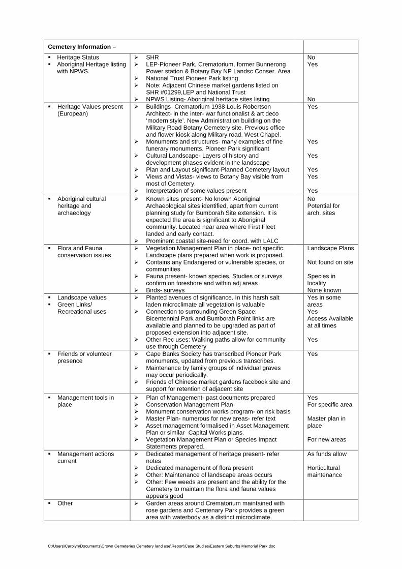
Cemetery Information –
Heritage Status Aboriginal Heritage listing
with NPWS.
SHR LEP-Pioneer Park, Crematorium, former Bunnerong
Power station & Botany Bay NP Landsc Conser. Area National Trust Pioneer Park listing Note: Adjacent Chinese market gardens listed on
SHR #01299,LEP and National Trust NPWS Listing- Aboriginal heritage sites listing
No Yes No
Heritage Values present (European)
Buildings- Crematorium 1938 Louis Robertson Architect- in the inter- war functionalist & art deco ‘modern style’. New Administration building on the Military Road Botany Cemetery site. Previous office and flower kiosk along Military road. West Chapel.
Monuments and structures- many examples of fine funerary monuments. Pioneer Park significant
Cultural Landscape- Layers of history and development phases evident in the landscape
Plan and Layout significant-Planned Cemetery layout Views and Vistas- views to Botany Bay visible from
most of Cemetery. Interpretation of some values present
Yes Yes Yes Yes Yes Yes
Aboriginal cultural heritage and archaeology
Known sites present- No known Aboriginal Archaeological sites identified, apart from current planning study for Bumborah Site extension. It is expected the area is significant to Aboriginal community. Located near area where First Fleet landed and early contact.
Prominent coastal site-need for coord. with LALC
No Potential for arch. sites
Flora and Fauna conservation issues
Vegetation Management Plan in place- not specific. Landscape plans prepared when work is proposed.
Contains any Endangered or vulnerable species, or communities
Fauna present- known species, Studies or surveys confirm on foreshore and within adj areas
Birds- surveys
Landscape Plans Not found on site Species in locality None known
Landscape values Green Links/
Recreational uses
Planted avenues of significance. In this harsh salt laden microclimate all vegetation is valuable
Connection to surrounding Green Space: Bicentennial Park and Bumborah Point links are available and planned to be upgraded as part of proposed extension into adjacent site.
Other Rec uses: Walking paths allow for community use through Cemetery
Yes in some areas Yes Access Available at all times Yes
Friends or volunteer presence
Cape Banks Society has transcribed Pioneer Park monuments, updated from previous transcribes.
Maintenance by family groups of individual graves may occur periodically.
Friends of Chinese market gardens facebook site and support for retention of adjacent site
Yes
Management tools in place
Plan of Management- past documents prepared Conservation Management Plan- Monument conservation works program- on risk basis Master Plan- numerous for new areas- refer text Asset management formalised in Asset Management
Plan or similar- Capital Works plans. Vegetation Management Plan or Species Impact
Statements prepared.
Yes For specific area Master plan in place For new areas
Management actions current
Dedicated management of heritage present- refer notes
Dedicated management of flora present Other: Maintenance of landscape areas occurs Other: Few weeds are present and the ability for the
Cemetery to maintain the flora and fauna values appears good
As funds allow Horticultural maintenance
Other Garden areas around Crematorium maintained with rose gardens and Centenary Park provides a green area with waterbody as a distinct microclimate.
C:\Users\Carolyn\Documents\Crown Cemeteries Cemetery land use\Report\Case Studies\Eastern Suburbs Memorial Park.doc
Conservation of Heritage and Environmental Values
The memorial park successfully manages various stages of development. The western area combines the original Botany Cemetery with the new ‘Garden of Innocence’ and ‘Garden of Loving memories’, along with a number of special memorials including the Stolen Generation memorial, the Police Memorial, the Military Memorial, the Bicycle Rider’s Memorial, and ‘Mention My Name’ memorial.
The memorial park is set within an area of high industrialisation, including the Boral Plant, along with the Container terminals of Port Botany. The open space connections between the Pioneer Park on Bunnerong Road, and the cemetery leading to Bicentennial Park and Yarra Bay allow for it to play an important role in ‘greenspace’ connections, with wonderful views over Yarra Bay.
Valued and maintained rose gardens are located around the Crematorium, protected from strong winds by an enclosing wall. These are memorial gardens and are being upgraded with various roses.
The central Centenary Park, undertaken for the cemetery’s centenary celebrations, also improves this greenspace, considerably improving a previous problem drainage area. Current links are possible from the cemetery to the foreshore walk and Bicentennial Park providing strong open space links between the uses.
Pioneer Park, located on the Bunnerong Road frontage has retained the main stelae and headstones of some of the monuments transferred from Devonshire St Cemetery, however it was not supported by National Trust nor most historians at the time, due to the loss of the footstones and the loss of landscape character of the graves themselves, when they were consolidated into a smaller area in the 1970s. They are located in back to back rows. With today’s knowledge the setout of the graves would have retained their inter-relationship and more of the grave furniture and landscape characteristics. There also remain far less than the original monuments transferred, with an account in Sue Zelinka’s book Tender Sympathies, a Social history of Botany Cemetery, referring to the ‘Saga of Pioneer Park’.
CLOCKWISE FROM TOP: MAGNIFICENT VIEWS OVER YARRA BAY AND BOTANY BAY, MARKET GARDEN AS SEEN FROM CEMETERY, PIONEER PARK MONUMENTS, NORTHERN SIDE OF MILITARY ROAD WITH THE POLICE MEMORIAL SET WITHIN PAPERBARKS
C:\Users\Carolyn\Documents\Crown Cemeteries Cemetery land use\Report\Case Studies\Eastern Suburbs Memorial Park.doc
As most of the monuments are sandstone of varied original quality, this material is more prone to deterioration with many not surviving the transfer from Devonshire St in the first place. Some monuments from the original Sydney Burial Ground are purportedly contained within those remaining, with these now having been relocated three times.
This is a past loss that cannot now be reversed, apart from looking at the remaining monuments to conserve and protect them from further deterioration as much as possible. The reasons for the past actions appear complex and mired by controversy. Conservation of the remaining monuments and management to reduce climatic deterioration and past deterioration due to wind born atmospheric pollution is recommended, along with recommendations for adjacent cemetery activities and maintenance. Funding for this work, and to involve specialists should be sought via grants and special funds. This is an activity that currently does not generate any revenue for the Trust, and as for many cemeteries is an ongoing factor that will continue as burial space decreases.
An addition to this precinct was unveiled in 2016 with interpretive panels for significant graves. This area has been designed as ‘First Fleet Memorial Park’, where 10 ‘First Fleeters’ and 2 naval personnel are memorialised. It is the only memorial where the names of every member of the first fleet have been cited, including the ships names, the crew, civilians and all convicts are recorded.
Interpretive signage and graphics interprets this event. This provides a significant memory of the early colonisation of Australia and is a destination that could be promoted, along with the other sculptural elements within the cemetery.
Interpretation of the Aboriginal heritage of the site and its context with the foreshore and La Perouse could also provide balance to the history of the area. It is understood this is intended for the Bumborah Point site. Success of Management in conservation of heritage and environmental values
Maintenance is undertaken by SMCT. The cemetery has grown over the years, mostly following a Plan, developed for various areas. This has enabled the environmental values of the site to be improved. Without the presence of the cemetery this area would probably have developed for industrial use, as has its northern and western boundaries. Much of the site’s character is obtained from its location on Botany Bay, with views over the water, with its sloping landform remaining intact. The presence of the cemetery has been able to interpret European cultural values for the community through the First Fleet Memorial Garden and previous Pioneer Park, with additional recommended actions noted.
The linking of this Cemetery to Bumborah Point and Yarra Bay Bicentennial Park will further increase the value of this cemetery through recreational walking trails and foreshore connections.
Management Tools Currently in Place- Discussion
Master Plans- 1986 Mitchell Clouston Master Plan. Later Mitchell Blanche update. A number of Master Plans have been prepared for the Cemetery over time. The original plan for Botany Cemetery as prepared by the Government Surveyor. In 1983 landscape architecture students at Sydney University were asked to look at areas adjacent to the old Total oil refinery. In order to include a wider look at the entire Cemetery in 1986, Landscape Architects Mitchell + Clouston were engaged to prepare development plans (essentially master plan) in three stages for the entire cemetery and crematorium. (Zelinka, Sue. 1991 Tender Sympathies) Concepts were presented by Jim Mitchell, including beautification of the Crematorium forecourt, entries, and a bicentennial project to improve the poor drainage line running through the site to become Centenary Park. Later, the landscape architects having changed to Mitchell Blanche, developed this area into a landscaped environment of linked water bodies. This included mature trees with a reticulated water system, replacing the old car bodies and waste areas from the previous industrial use drainage overflow. The poor conditions of this part of the site have been improved directly as a result of the cemetery presence and the work carried out. Many of the benefits as a result of the Master Plan involved the consideration of screening areas adjacent to the site- using the placement of taller vaults along these boundaries and working with the natural contours of the land to provide for drainage, tree planting, restoration of gullies and improvement works.
C:\Users\Carolyn\Documents\Crown Cemeteries Cemetery land use\Report\Case Studies\Eastern Suburbs Memorial Park.doc
Master plans and Landscape Plans are being prepared for cemetery areas when they are developed, within some for the north- western areas of the site, with consideration of underground catacomb style areas, making use of the slope with graves above. The Bumborah site will also provide a Master plan, as well as assessment of opportunities to incorporate the values present on that site and integrate it with the cemetery and other areas beyond.
Maintenance Schedules or Capital Works programs
The annual works are determined through Capital works programs allocating funds and personnel to the projects and ongoing maintenance work.
Grants and heritage assistance could be the subject of ongoing Capital Works to assist in the management of heritage on the site.
Interpretation and Signage-
Significant work was undertaken as part of development of First Fleet Memorial Park- extending the original Pioneer Memorial Park. Interpretive signage was included in this work.
Multiple uses-
The Cemetery has a number of memorials that go beyond the site itself, ie Police Memorial, Military Memorial commemorating the Battle of Pozieres, 100 years on. Also included is a memorial for the War Widows Guild and Legacy along with the other special memorials including the Stolen Generation memorial and others noted previously in this document. Other events such as open days, Christmas carols and special memorial commemorations, all contribute to the community in bringing them to this place.
Address: Delhi Road – North Ryde
Local Government Area: Ryde Council
Managed by: Invocare Pty Ltd
Short Description and General Comments:
The crematorium building, designed by Bloomfield, was the second to be built in NSW after Rookwood’s, by the same architect. Completed in 1933 the building is built in the inter-war Romanesque style of architecture, with a decorative tower. Additional Chapels have been constructed in a sympathetic style with memorial gardens providing a distinctive Mediterranean setting. (OEH Heritage Listing, updated Dec 12) The gardens have an historical association with Norman Weekes, who expanded the landscape philosophy from the 1940’s to the 1960’s. These gardens illustrate an aesthetic significance as an inter-war period of landscape design, with a variety of garden areas, from bushland settings to topiary gardens associated with the Crematorium building.
The crematorium and associated gardens are sited on a prominent ridge allowing views to many high points in the locality. Views to the Chatswood towers are available. The placement of the relatively low buildings on the site afford bushland views and a vegetated skyline from other prominent high points. As such, it maintains a ‘green’ ridgeline in contrast to the other surrounding commercial areas, providing visual relief when combined with the heavily vegetated surrounding Lane Cove National Park.
Many prominent individuals are interred in the Cemetery, with the ability to memorialise these individuals for future generations.
C:\Users\Carolyn\Documents\Crown Cemeteries Cemetery land use\Report\Case Studies\Northern Suburbs Crematorium DRAFT.doc
Northern Suburbs Memorial Gardens and Crematorium: 1922 land set aside 1933- present
THE CREMATORIUM IS SET WITHIN A COMPLEMENTARY LANDSCAPE DESIGNED AS A WALLED ITALIAN GARDEN
C:\Users\Carolyn\Documents\Crown Cemeteries Cemetery land use\Report\Case Studies\Northern Suburbs Crematorium DRAFT.doc
Cemetery Information – Heritage Status SHR- Listed as significant early 20th Century
Crematorium building with a designed landscapesetting
LEP- Listing Number I46 Ryde LEP Sep 14 National Trust
Yes
Yes Yes
Heritage Values present(European)
Buildings- Crematorium by Bloomfield, the 2ndcrematorium to be built in NSW, historicallysignificant
Skyline function centre, provides low elevationbuilding set within gardens.
Monuments and structures- Columbarium walls alongboundaries and within courtyards.
Cultural Landscape- Gardens associated with the crematorium create a complementary setting for the crematorium in the style of the building, associated with Norman Weekes.
Plan and Layout significant- circulation routes, gardens and layout form a significant planned setting
Views and Vistas- significant, long views available Interpretation of values present
Yes
Yes
Yes
Yes
Yes
Yes Yes
Aboriginal culturalheritage andarchaeology
Known sites present- Unknown Strong association with the original aboriginal
inhabitants of this area of the north shore, along withthe important bushland areas adjacent within LaneCover National Park.
Flora and Faunaconservation issues
Vegetation Management Plan- CMP guidesmaintenance
Contains any Endangered or vulnerable species, orcommunities- unknown
Fauna present-The edges merge with the Lane CoveNational Park with a high level of indigenous canopytrees maintained, allowing for fauna and bird use.
Birds
Vegetation is managed by horticultural trained staff Yes
Yes Landscape values Green Links/
Recreational uses
Planted avenues of significance with trees of funerary significance marking path nodes, and entries. Strong use of clipped conifers and pines complementing the Mediterranean style of the Crematorium. Connection to surrounding Green Space: Significant visual connections to adjacent Lane Cove National Park. No physical connection via walkways are present, except through front entry. Other Rec uses: Other walking paths within the Cemetery do not prohibit general community use as passive open space.
Yes
Yes. Open only through entry gates
Gates close at sunset.
Friends or volunteerpresence
Bushcare- Adjacent Lane Cove National Park hasand a ‘Friends’ group.
Maintenance: High by a dedicated team of gardeners(hort C trained) for all of the areas.
Yes
Management tools inplace
Plan of Management- part of CMP Conservation Management Plan & Landscape Master
Plan- 2005 Betteridge and Beaver- includes heritage, interpretation, landscape conservation
Monument conservation works program- Asset management formalised in Asset Management
Plan Vegetation Management Plan or Species Impact
Statements
Yes Yes
As required Part of maintenance On site team- no special plan
Management actionscurrent
Dedicated management of heritage present Dedicated management of flora present- part of
general maintenance Other: Regular maintenance of all landscape evident-
including maintaining the clipped conifers and Mediterranean style garden around the crematorium.
Yes
Yes
C:\Users\Carolyn\Documents\Crown Cemeteries Cemetery land use\Report\Case Studies\Northern Suburbs Crematorium DRAFT.doc
Conservation of Heritage and Environmental Values
Discussion:
The Crematorium is a fine example of a managed and maintained heritage precinct with the cultural landscape remaining intact.
Maintenance of site is undertaken by Invocare’s gardening team. Integrity of original Crematorium plan and layout remains intact. The landscape character is intact and can be appreciated from many viewpoints. New memorial gardens are provided, catering to the bushland memorial popularity, along the bushland edges of the site. Trees are retained and managed to maintain a bushland boundary and character. Memorial styles are controlled in the original heritage areas with more flexibility in the newer areas. Further design guidelines in these areas would assist in these being of higher design quality.
The visual relief provided by the Crematorium on this prominent ridge provides important bushland views from surrounding areas, due to the low heights of the crematorium and its comfortable setting within the landscape. In turn long views are available from the Cemetery over this part of the north shore. This is beneficial in the context of the development areas surrounding the area and provides ‘green links’ in this part of Sydney, of immense environmental benefit.
Visual links with the green space and important indigenous vegetation of the adjacent Lane Cove National Park are available. The potential for physical connections via walking trails are possible, but would need to be managed to deal with the impacts this may create on this memorial landscape- eg. higher maintenance requirements.
LONG VIEWS FROM THE CREMATORIUM RIDGELINE- BOTTOM, BUSHLAND MEMORIAL GARDENS- TOP.
C:\Users\Carolyn\Documents\Crown Cemeteries Cemetery land use\Report\Case Studies\Northern Suburbs Crematorium DRAFT.doc
Management Tools Currently in Place- Discussion
Conservation Management Plan and Landscape Master PLan
2005 Musecape and David Beaver.
This document has identified the character and nature of the place, site management issues and recommendations as well as precinct analysis and policy recommendations. It identifies the key contributions by designers such as Bloomfield and later Norman Weekes in providing ongoing designs that complemented the original schemes. A comprehensive list of plant species gleaned from a planting scheme by Norman Weekes, has been interpreted and current nomenclature provided to enable this to be utilised for ongoing garden replacement species.
Statements of Heritage Impact have occurred when additions or alterations have been required to the Crematorium building, with this being done by Noel Bell Ridley Smith and Partners in 1984 and 2004.
Heritage studies for Council include this site as part of the heritage of the locality.
On-site training of the horticulturalists on site occurs, with additional input from arborist’s appointed to review and advise on tree health annually as a minimum.
Pruning within the site aims at maintaining vistas from the original plan and design.
C:\Users\Carolyn\Documents\Crown Cemeteries Cemetery land use\Report\Case Studies\Castlereagh General Cemetery.doc
Address: Church Lane, Cnr Wilchard Rd, Castlereagh
Local Government Area: Penrith
Managed by: Penrith City Council
Short Description and General Comments:
The Cemetery is a pioneer Cemetery and one of the five Governor Macquarie towns. It is part of the few remaining areas of the original Castlereagh town, proclaimed in 1810. These towns were proposed to bring together settlement in the colony. Families did not take up in the town, preferring to stay on their farms by the Nepean River.
It contains First Fleet graves, as well as early pioneering families. Interment is no longer permitted in the Cemetery.
Castlereagh Cemetery: 1811-1973
PHOTO FROM CLOSE TO ENTRY
C:\Users\Carolyn\Documents\Crown Cemeteries Cemetery land use\Report\Case Studies\Castlereagh General Cemetery.doc
Cemetery Information – Castlereagh General Cemetery Penrith
Heritage Status Aboriginal Heritage Values
or listing with NPWS
Pioneer Cemetery State Heritage Register SHR Local Environment Plan LEP National Trust NPWS Listing for Aboriginal Heritage site
No Yes Yes No
Heritage Values present (European)
No buildings Monuments and structures- Fine examples of early
pioneer grave furniture. Cultural Landscape- Natural grave setting, similar to
bushland Cemetery. Plan and layout significant as informal bushland style
cemetery. Views and vistas- views at entry important into the
Cemetery. Flat ground with limited long views. Interpretation of values present
No Yes Yes Yes Yes Yes
Aboriginal cultural heritage and archaeology
No known sites present
Flora and Fauna conservation issues
Vegetation Management Plan in place. Part of PoM Contains Castlereagh Ironbark vegetation, and is located
adjacent to the Castlereagh Woodlands. May include Endangered population Dillwynia tenuifolia
OEH, identified in 1989 (Lembit). Fauna present: Abundant birdlife due to excellent native
grass and groundcover, dense shrub layer for small bird habitat. Boundaries provide cover for other fauna.
Yes Yes Yes Yes
Landscape Values Green Links
Excellent connection to surrounding woodland on 3 sides. Adjacent low density houses set on large lots provide
ability to connect with green corridors. Walking paths informal inside Cemetery. Locked at night.
Some break-ins known
Yes Access only avail during day
Friends or volunteer presence
Friends of Castlereagh Cemetery have been active in the past, but appear to be no longer active.
Maintenance by family groups of individual graves may occur periodically.
No Yes
Management tools in place
Plan of Management- Council Conservation Management Plan Monument conservation works apparent- family group
maintenance Asset management formalised in Asset Management
Plan or similar. Vegetation Management Plan or Species Impact
Statements prepared.
Yes Yes Yes Part of PoM No
Management actions current
Dedicated management heritage present Dedicated management of flora present Periodic mowing of the predominant native grasses,
retain the integrity and allow for self-seeding. Sustainable management practices
Few weeds are present and the ability for the Cemetery to maintain the flora and fauna values is high
Yes Yes
C:\Users\Carolyn\Documents\Crown Cemeteries Cemetery land use\Report\Case Studies\Castlereagh General Cemetery.doc
Conservation of Heritage and Environmental Values
The Cemetery is significant in conserving heritage and environmental values where the Cemetery is no longer operational. It is an important location of early pioneer graves and marks the settlement history of the early colony and the land grants in the west of Sydney. As a surviving example of Governor Macquarie’s proposed towns to promote settlement in the colony, this is the only remaining part of the proposed town. Proclaimed in 1810 this is an important part of Sydney’s settlement pattern.
Also sustaining remnant Castlereagh Ironbark vegetation, a rare vegetation community, along with providing habitat for birdlife and fauna, this Cemetery fulfils multiple functions and is a valuable example of the ongoing functions Cemeteries can have beyond their ‘useful life’ as a Cemetery.
Management Tools Currently in Place- Discussion
Plan of Management
A Plan of Management for all of Penrith Council’s Cemeteries was prepared in 2013, including Castlereagh General Cemetery. This provided an assessment of the cemetery values based on heritage, landscape and visual, infrastructure and management. Management principles, guidelines and actions based on these values were identified and key performance measures. The cemetery is to be managed as a historic cemetery with conservation of all historic monuments undertaken with priorities to conserve those at the highest risk.
Conservation Management Plan
A CMP was prepared by Don Godden and Associates in 1989 for Penrith Council/s cemeteries. In 2001 Otto Cserhalmi & Partners prepared a Conservation Management and Maintenance Plan for Castlereagh cemetery. This provided conservation principles and was used by Council for the management of the site.
MONUMENTS SET WITHIN NATIVE GRASSLAND AND WOODLAND, HERITAGE GRAVE FENCING AND BORDERS WITH FOOTSTONES REMAINING, SANDSTONE ALTER AND ENTRY INTERPRETIVE SIGN
C:\Users\Carolyn\Documents\Crown Cemeteries Cemetery land use\Report\Case Studies\Castlereagh General Cemetery.doc
Maintenance Works programs
Council mows the predominantly native grasses as outlined in the PoM, to encourage the seeding of the grasses, promote the bushland character of the cemetery, as well as regenerating the vegetation to reduce weed encroachment. This has been successful. The mowing is not to maintain a pristine lawn, which would be totally inappropriate to the cultural landscape character of the cemetery. A guide for mowing and maintenance of the grave surrounds is included in the PoM and on-site activities are following the principles of management of these values successfully.
Interpretation and Signage
A main entry sign identifies the heritage of the cemetery and its origin as one of Macquarie’s towns. Photographs explain the context. Other oral history and family history records are available in Penrith Council Library Local Studies section providing information about some of the pioneering families buried within the cemetery. Rope and Pulley, namely two, with information from the Rope and Pulley family history group based are referenced. This allows a greater understanding of the historical associations of the locality, the social groups and research and ongoing research potential.
C:\Users\Carolyn\Documents\Crown Cemeteries Cemetery land use\Report\Case Studies\Rookwood Necropolis Cemetery.doc
Address: Hawthorne Avenue Rookwood, Barnet Avenue Rookwood are within the site however it is a suburb within itself.
Area: 286 Hectares
Local Government Area: Cumberland Council, division Auburn
Managed by: Rookwood Necropolis Trust, Rookwood General Cemetery Reserve Trust, Catholic Cemeteries and Crematoria. Invocare leases the Rookwood Memorial Gardens and Crematorium whilst Office of War Graves maintins the Sydney War Cemetery and Garden of Remembrance.
Short Description and General Comments:
Rookwood is the one of the largest burial grounds in the world and contains the largest 19th Century Cemetery within Australia. The history and features of Rookwood are well documented. An update to the Plan of Management for Rookwood was published in 2014 outlining the values, strategic directions, management principles, guidelines and actions.
As part of the Plan of Management related management plans have been rolled out over the last 3 years.
As part of the NSW Cemetery Legislation reforms Rookwood Necropolis Trust is responsible for management of common infrastructure, boundaries and roads. The Rookwood General Cemeteries Reserve Trust united the previous Anglican, General, Independent, Jewish and Muslim Trust.
Catholic Cemeteries and Crematoria manage the Catholic Cemetery within Rookwood. Other management areas are included within the Sydney War Graves, and the Rookwood Memorial Gardens and Crematorium.
Rookwood Necropolis: 1867-present
AERIAL PHOTO OF ROOKWOOD 2010
C:\Users\Carolyn\Documents\Crown Cemeteries Cemetery land use\Report\Case Studies\Rookwood Necropolis Cemetery.doc
Rookwood Necropolis- Rookwood
Heritage Status Aboriginal Heritage Values
or listing with NPWS
SHR- SHR No. 00718 for the first 200 acres of Cemetery built LEP National Trust NPWS Listing for Aboriginal Heritage site
Yes Yes Yes No
Heritage Values present (European)
Many buildings within Rookwood display significant heritage values and are acknowledged on various heritage lists.
Monuments and structures- Fine examples of monuments over many decades display fine stonemasonry art.
Landmark structures abound throughout the Cemetery. Cultural Landscape- significant and varied cultural landscapes
throughout the entire Necropolis of 286 Hectares. Plan and layout significant and representative of ongoing phases
of use. Views and vistas- Views from Cemetery available to the CBD,
Blue mountains, Olympic site. Many important internal views to structures and monuments.
Interpretation of values present
Yes Yes Yes Yes Yes Yes Yes
Aboriginal cultural heritage and archaeology
No known sites present- areas of high archaeological potential identified in the Conservation Management Plan– to be investigated further
Yes
Flora and Fauna conservation issues
Vegetation Management Plan in place- Property Management Plan for vegetation and fauna conservation.
Endangered ecological communities, species, and vulnerable species and communities are listed within the OEH TSC Act 1995, and amended Biodiversity Conservation Act 2016.
It includes Endangered flora; Pomaderris prunifolia, Wahlenbergia multicaulis, vulnerable flora; Acacia pubescens and Epacris purpurascens var. purpurascens. OEH. (Note: TSC Act terminology used)
Fauna present: Threatened or vulnerable fauna populations; Grey headed Flying Fox, Green and Golden Bell Frog, Regent Honeyeater, Common Bent Wing Bat.
Cultural plantings present with heritage rose gardens and gardenesque plantings from early plans.
Yes Yes Yes Yes Yes
Landscape Values Green Links
Good connection within the site of Vegetation Conservation Areas.
Open space links with pedestrian access available along boundaries into the site for use of walking paths, and all facilities.
Walking paths, heritage walks, annual sculpture exhibitions, and use of all of the site is freely available. Locked at night.
Yes Yes Yes Access only avail during day
Friends or volunteer presence
Friends of Rookwood have been active for many years and run regular themed tours, as well as a Newsletter and Open Day.
Maintenance by family groups of individual graves occurs with some areas that are visited regularly by family, particularly certain cultural groups.
The Friends of Rookwood also fund restoration of various monuments, often with assistance from the Trusts. RGCRT.
Yes Yes
Management tools in place
Plan of Management- 2014 and Management Unit Policies Management Unit Policies- 2014 Conservation Management Plan- Draft 2016 Monument conservation works apparent- all Trusts Asset management formalised in Asset Management Plan or
similar. Vegetation Management Plan or Species Impact Statements
prepared- Property Management Plan- 2014 Bushland Management Plan 2015.
Flora and Fauna study- 2013 Landscape Master Plan- 2014 Tree Management Study completed- 2016 Traffic Study completed Canal Study completed 2015 Visual Significance Study- 2010
Yes Yes Yes Yes Yes Yes Yes Yes Yes Yes Yes Yes
Management actions current
Dedicated management heritage present Dedicated management of flora and fauna present The Trusts maintain their individual areas within the Necropolis.
Yes Yes Yes
C:\Users\Carolyn\Documents\Crown Cemeteries Cemetery land use\Report\Case Studies\Rookwood Necropolis Cemetery.doc
Conservation of Heritage and Environmental Values
Discussion:
A large area of dedicated land, as a Crown Cemetery, Rookwood actively manages heritage and environmental values. Due to its size there are many areas of heritage starting from before the cemetery opened, with monuments transferred from Devonshire St, and Lewisham. Heritage conservation of monuments is undertaken in the No. 1 burial areas to ensure these do not deteriorate. The Jewish monuments have been part of a conservation program ensuring these remain intact for future generations. This task is a huge undertaking and is progressively carried out as restoration funds permit.
There are significant representations of burial practices for all faiths over many years, providing a rich social history. Many management documents guide the work associated with these values. These are updated on a regular basis.
Flora and fauna habitat in the cemetery is managed through a bushland management program that reports to the Office of Environment and Heritage. Endangered Ecological communities and species are present within 21 hectares of Vegetation Conservation Areas, where further burial is not permitted.
Exotic planting areas of cultural heritage value exist, with significant heritage rose gardens located in a number of areas. These are assisted in their maintenance by the heritage rose society. Other plantings from early plans include significant tree plantings at nodes, along circulation routes and defining boundaries and different uses. These mark the importance of early designers including Charles Moore and JH Maiden, who had significant roles to play in areas in Sydney’s development. These included the Botanic Gardens, Centennial Park and some street layouts within Sydney, where popular street trees and palms were planted. Also Simeon Pierce, who became the Mayor of Randwick was a trustee of the Anglian Cemetery and was responsible for selection of trees and laying out areas around the Serpentine.
Architectural masterpieces within the cemetery include some of the rest houses in the No. 1 areas, St Michael the Archangel, The Elephant house, The Crematorium, and vaults such as the Frazer vault. This also extends to the monuments where funerary architecture displays magnificent stonemasonry skills.
The No. 1 Mortuary Station, was a significant architectural structure by James Barnett, unfortunately now relocated outside the Cemetery. Its link with the Mortuary Station at Central Station is not entirely lost, with an interpretive structure, landscape layout and signage marking the site of this important part of the early history of Rookwood.
As an ongoing cemetery providing functions that extend well beyond burial and interment, the cemetery successfully manages multiples uses and values. It is probably the best example in Sydney of the use of a cemetery for open space, and visitation other than for interment and is a model that could be followed for many ot hers.
C:\Users\Carolyn\Documents\Crown Cemeteries Cemetery land use\Report\Case Studies\Rookwood Necropolis Cemetery.doc
C:\Users\Carolyn\Documents\Crown Cemeteries Cemetery land use\Report\Case Studies\Rookwood Necropolis Cemetery.doc
This does require resources and will continue to be a management challenge. New initiatives will undoubtedly be required for this to continue, however these are part of the ongoing cemetery functions that will need to be maintained into the future.
Multipurpose functions within Rookwood include an Open Day every second year, an annual HIDDEN Sculpture exhibition, carols, services on special days, and recitals to name a few. The Friends of Rookwood carry out many fund raising and restoration activities with one noted below.
Samuel and Rosetta Terry monument is shown in the original location in Devonshire St and then far right relocated to Rookwood. Samuel was an emancipated convict, who arrived on the Earl Cornwallis in 18001, later becoming a merchant in NSW. His wife Rosetta Terry, nee Pracy arrived on the Hillsborough in 1799. She married Henry in 1810. This monument is being restored by the Family, Friends of Rookwood and RGCRT. The families started a donation drive, workiing with the Friends. (Information from R.I.P NEWSLETTER, March 2018. Newsletter of The Friends of Rookwood Inc. Vol 23 Number 1)
The RGCRT has a monumental heritage team with Sach Killam, monumental team leader. His experience over many years with masonry and cemeteries provides significant value to the knowledge and understanding of the place. Ongoing restoration work is undertaken in the cemetery and also beyond to contribute these values to other cemeteries.
Management Tools current in place- Discussion
The following descriptions are a brief summary
Plan of Management 2014 Department of Primary Industries
This is the overriding document prepared to manage the values within the Rookwood site. It outlines the key information about the place, including Aboriginal heritage, history, natural and ecological values, and social values as well as management framework, governance and sustainability issues. The challenges are identified to balance demand and supply, burial practices, ecology, environment, heritage, financial sustainability, governance and communication.
It outlines how the place is to be managed through principles, guidelines and actions. A key to this PoM is the supporting documents as Related Management Plans that deal with details and ongoing issues.
Management Unit Policies 2014 DEM (Aust)
Prepared to provide more detailed principles and guidelines for each management area, as a component of the PoM. The management units group areas with similar characteristics, as a result of the Visual Significance Study prepared in 2010. The areas are defined through similar physical, cultural and visual values, rather than denominational areas or management structure. It is a landscape led framework with areas defining key management priorities for each Unit.
Landscape Master Plan 2014- Florence Jacquet
Providing a detailed analysis of this large site the Master Plan idenfies issues to be addressed and a number of proposals, based on the need for beautification/consistency, increased recreational activities, the need for sustainability and an implementation strategy. Design guidelines for various elements are included.
Building on heritage and archaeological studies prepared over many years the Draft CMP draws this information together as well as updating significance assessment, recommended conservation policies and management actions. Heritage Asset Management Sheets are prepared for key cultural landscapes,
PHOTOS OF TERRY MONUMENT. SOURCE: R.I.P NEWSLETTER ROOKWOOD SHOWING ORIGINAL LOCATION OF MONUMENT AT OLD DEVONSHIRE ST CEMETERY AND LATER RELOCATED TO ROOKWOOD AFTER THE MONUMENTS WERE MOVED TO MAKE WAY FOR CONSTRUCTION OF CENTRAL STATION.
C:\Users\Carolyn\Documents\Crown Cemeteries Cemetery land use\Report\Case Studies\Rookwood Necropolis Cemetery.doc
heritage items, memorial groups, structures and infrastructure. An interpretation strategy and Aboriginal Due Diligence study is included.
Property Management Plan 2015-2020 UBM Ecological Consultants and C.Tallents
This document builds on earlier Vegetation Management Plans prepared for the site and the management of the endangered ecological communities and species present on the site. It deals with the ongoing bushland management at Rookwood, maintaining the ecology, and management actions that are part of an ongoing bushland management program, carried out since 1996 and earlier. An audit was carried out every two years and was then extended to five years to review the actions against the performance measures. This work is carried out with approval and authorisation of the Office of Environment and Heritage.
As part of the ongoing work to the Vegetation Conservation Areas (VCAs) at Rookwood the Bushland Management Plan identifies the core performance measures for the VCAs with the core management priorities for each area. Part of the management of the bushland is a Threatened Plant Census for the endangered ecological communities, and species within the site, carried out every five years and reported to Office of Environment and Heritage. (OEH)
Survey of Rookwood Necropolis Wahlenbergia multicaulis annual reports. Smith P and J.
An Annual Plant Census for Wahlenbergia multicaulis is a requirement of the PMP and undertaken by experts in identification and management of this species.
Biodiversity Studies: Flora and Fauna investigations for Native Bushland at Rookwood Necropolis, August 2013. UBM Ecological Consultants
This updates the previous surveys carried out over various years as a baseline for the updated PMP. It has identified the presence of the vegetation communities and species within the VCAs as well as fauna extant and those migratory species visiting the site.
Visual Significance Study DEM August 2010
Prepared to extend the previous studies from the earlier Plans of Management where aesthetic characteristics were considered, this study assessed the landscape, visual and cultural significance through consideration of the layers of history, landmarks, burial types, topography, vegetation and landscape pattern, circulation routes, views internal and external, ability to interpret historic layers and ability to absorb change. Key significance was defined and a comprehensive analysis of each was undertaken, with aerial photographic layers over time, assisting an understanding the layers of the site. A brief summary of this is embodied in the Management Unit Policies.
Others:
A Traffic Study, identifying the traffic volumes through the primary road network has informed activities within the Necropolis.
A Canal Study by Hyder Consulting has reported on the condition of the historic canals and recommended remedial works and maintenance actions.
Wayfinding and Signage Strategy 2016-2017 by AGD, prepared a wayfinding study to improve navigating around this huge site. A signage strategy and suite of signs was developed.
Other reports are prepared when new works are proposed or specific assessment is required.