Oregon Section G - 55.2 miles Start - Hwy 35, mile 2091.7 [near Barlow Pass] End - Cascade Locks, mile 2146.9 Elevation Gain +9,876' Elevation Loss -13,821' Elevation Change -3,945' ---------- Timberline Lodge [timberlinelodge.com, 503-272-3189] is a ski resort, restaurant [excellent AYCE buffet], and lodge 2/10 mile S of the PCT that accepts hiker resupply packages [$]. ------- Ship resupply packers [$5] by USPS or UPS: (Your Name) c/o WY'East Store Timberline Lodge Ski Area 27500 E Timberline Rd Timberline Lodge, OR 97028 ---Be sure to write "Hold for PCT Hiker" on package.
The small community of Government Camp is 2.1 miles W on Hwy 35, then 2.7 miles W on Hwy 26
BarlowPassTR - Barlow Pass Trailhead, paved parking, picnic table, trash cans, and outhouse. - mi 2091.5 - 4164 ft Hwy35 - Highway 35, Barlow Pass. The small community of Government Camp is 2.1 miles W on Hwy 35, then 2.7 miles W on Hwy 26 - mi 2091.7 - 4164 ft WACS2095 - Stream, campsites. - mi 2094.5 - 4822 ft KohnstammArea - Richard L. Kohnstamm Memorial Area boundary. - mi 2094.9 - 5046 ft TimberlineTR - Timberline Trail #600 junction - mi 2095.6 - 5345 ft SalmonRiver - Salmon River - mi 2096.7 - 5982 ft TimberlineLodge - Timberline Lodge - mi 2097 - 5924 ft TimberlineLodgeTR - Trail junction to Timberline Lodge - mi 2097 - 6048 ft Radio2097 - Radio antenna near a ski lift. - mi 2097.1 - 6077 ft Ski2097 - Another ski lift. - mi 2097.4 - 6039 ft MountaineerTR - Mountaineer Trail #798 junction - mi 2097.6 - 5985 ft MountHoodWild - Mount Hood Wilderness boundary - mi 2097.7 - 5959 ft LittleZigzagRiver - Little Zigzag River - mi 2098 - 5832 ft HiddenLakeTR2 - Hidden Lake Trail junction - mi 2098.4 - 5715 ft
These maps are provided as a free service to PCT hikers. I believe the information is accurate but they may contain errors. The maps are distributed in the hope that they will be useful, but WITHOUT ANY WARRANTY; without even the implied warranty of MERCHANTABILITY or FITNESS FOR A PARTICULAR PURPOSE. -Halfmile
LittleZigzagRiver - Little Zigzag River - mi 2098 - 5832 ft HiddenLakeTR2 - Hidden Lake Trail junction - mi 2098.4 - 5715 ft WA2100 - Spring flowing across the trail. - mi 2099.8 - 5066 ft ZigzagRiver - Zigzag River - mi 2100.3 - 4776 ft ParadiseLoopTR - Paradise Loop Trail junction - mi 2100.7 - 5020 ft ParadiseParkTR - Paradise Park Trail #778 junction - mi 2101.2 - 5247 ft LostCreek - Lost Creek - mi 2102 - 5375 ft RushingWaterCreek - Headwaters of Rushing Water Creek. May be underground near the PCT. - mi 2102.6 - 5480 ft RushingWaterCreekTrib - Small tributary of Rushing Water Creek. - mi 2103 - 5487 ft ParadiseParkLoopTR - Paradise Park Loop Trail junction - mi 2103.2 - 5447 ft CS2106 - Campsite - mi 2106.1 - 3485 ft RushingWaterCreek2 - Rushing Water Creek, large campsite. - mi 2106.3 - 3388 ft SandyRiver - Sandy River, often silty, can be a dangerous crossing. - mi 2106.4 - 3350 ft WACS2107 - Trailside stream, large campsite nearby. - mi 2106.7 - 3258 ft RamonaFalls - Ramona Falls. No camping within 500 feet of the falls. - mi 2106.8 - 3511 ft TimberlineTR2 - Timberline Trail #600 junction (Ramona Falls alternate trail). - mi 2106.9 - 3323 ft
The 2 mile Ramona Falls alternate passes beautiful Ramona Falls, bypassing 2 miles of the PCT.
CS2106 - Campsite - mi 2106.1 - 3485 ft RushingWaterCreek2 - Rushing Water Creek, large campsite. - mi 2106.3 - 3388 ft SandyRiver - Sandy River, often silty, can be a dangerous crossing. - mi 2106.4 - 3350 ft WACS2107 - Trailside stream, large campsite nearby. - mi 2106.7 - 3258 ft RamonaFalls - Ramona Falls. No camping within 500 feet of the falls. - mi 2106.8 - 3511 ft TimberlineTR2 - Timberline Trail #600 junction (Ramona Falls alternate trail). - mi 2106.9 - 3323 ft SandyRiverTR - Sandy River Trail junction to a trailhead. - mi 2108.4 - 2767 ft
The 2 mile Ramona Falls alternate passes beautiful Ramona Falls, bypassing 2 miles of the PCT.
RamonaCreek - Ramona Creek with a log footbridge. - mi 2108.5 - 2803 ft RamonaFallsTR - Ramona Falls Trail #797 junction - mi 2108.9 - 2810 ft MuddyFork - Muddy Fork, hiker bridge washed out in 2014 but fallen logs allowed crossing, campsites nearby. - mi 2108.9 - 2797 ft MuddyForkTrib - Seasonal tributary of Muddy Fork - mi 2110 - 3564 ft TimberlineTR3 - Timberline Trail #600 junction, campsite nearby. - mi 2111.4 - 4341 ft TopSpurTR - Top Spur Trail #785 junction - mi 2111.4 - 4328 ft LoloPass - Lolo Pass, campsite with a picnic table - mi 2114.2 - 3437 ft LoloPassRD - Paved Lolo Pass Road, near junction of Lost Lake Road and Forest Road 18. - mi 2114.2 - 3436 ft PL2114 - High voltage power line - mi 2114.3 - 3487 ft WForkHoodRiverTrib - Small tributary of the West Fork Hood River, small campsite nearby. - mi 2114.6 - 3609 ft
HuckleberryMtnTR - Huckleberry Mountain Trail #617 junction - mi 2118.4 - 4020 ft CS2118 - Small campsite - mi 2118.4 - 4020 ft SalvationSpringTR - Salvation Spring Trail junction - mi 2118.6 - 4117 ft SalvationSpring - Salvation Spring, campsites nearby. - mi 2118.6 - 4085 ft CS2121 - Campsite - mi 2121.3 - 4245 ft
BuckPeakSpring - Small seasonal spring next to PCT, below Buck Peak. - mi 2122.1 - 4426 ft Road660 - Abandoned unpaved Road 660. - mi 2125.8 - 4279 ft IndianSpringsCG - Indian Springs Campground, abandoned, spring nearby. - mi 2127.6 - 4245 ft
The Eagle Creek Alternate Route is a spectacular and popular 15.4 mile route used by many [probably most] PCT hikers, that bypasses 19 miles of the official PCT. At the Indian Springs Campground, take the side trail to the left of the old picnic table to the Indian Springs Trail Number 435. The Indian Springs Trail connects with the Eagle Creek Trail in two miles. ---------- IndianSpringsCG - Indian Springs Campground [abandoned], water, Eagle Creek alternate trail junction. [alt mi 0]- 4242 ft EagleCrkTr - Indian Springs Trail 435 meets Eagle Creek Trail. [alt mi 2] - 2567 ft TunnelFall - Tunnel Falls - [alt mi 5.9] - 1092 ft 4MiBridge - 4 1/2 mile bridge - [alt mi 7.9] - 702 ft -- See Page 6A for more route description
Support PCTA.org Leave No Trace
IndianSpringsCG - Indian Springs Campground, abandoned, spring nearby. - mi 2127.6 - 4245 ft HatfieldWild - Mark O Hatfield Wilderness boundary - mi 2128.6 - 4099 ft WahtumLake - Wahtum Lake, campsites. - mi 2130.6 - 3774 ft HermanCreekTR - Herman Creek Trail #406 junction - mi 2132.2 - 4278 ft ChinidereCutoffTR - Chinidere Cutoff Trail #406M junction - mi 2132.4 - 4270 ft
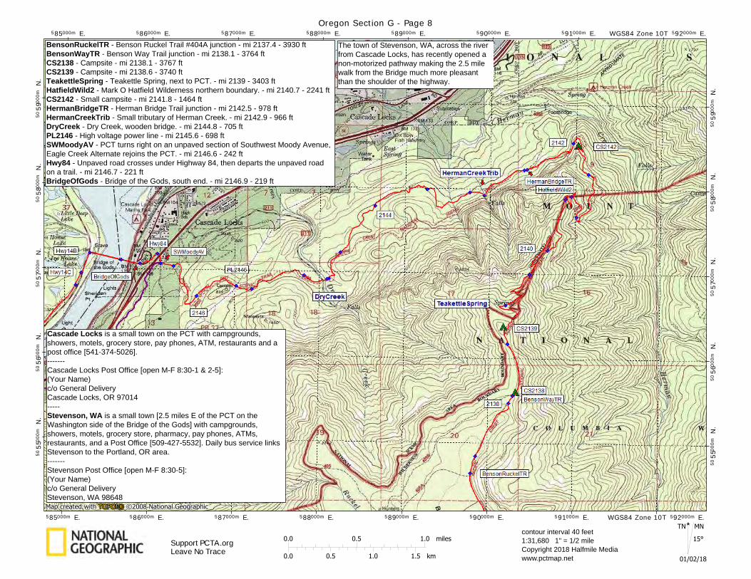
SWMoodyAV - PCT turns right on an unpaved section of Southwest Moody Avenue, Eagle Creek Alternate rejoins the PCT. - mi 2146.6 - 242 ft Hwy84 - Unpaved road crosses under Highway 84, then departs the unpaved road on a trail. - mi 2146.7 - 221 ft BridgeOfGods - Bridge of the Gods, south end. - mi 2146.9 - 219 ft See WA Sec H map for Washington waypoints ---------- Cascade Locks is a small town on the PCT with campgrounds, showers, motels, grocery store, pay phones, ATM, restaurants and a post office [541-374-5026]. ------- Cascade Locks Post Office [open M-F 8:30-1 & 2-5]: (Your Name) c/o General Delivery Cascade Locks, OR 97014 ----- Stevenson, WA is a small town [2.5 miles E of the PCT on the Washington side of the Bridge of the Gods] with campgrounds, showers, motels, grocery store, pharmacy, pay phones, ATMs, restaurants, and a Post Office [509-427-5532]. Daily bus service links Stevenson to the Portland, OR area. ------- Stevenson Post Office [open M-F 8:30-5]: (Your Name) c/o General Delivery Stevenson, WA 98648
The Eagle Creek Trail ends at a parking area and road. Walk toward the campground and take the Gorge Trail #400 to Cascade Locks.
Support PCTA.org Leave No Trace
Eagle Creek Alternate 4MiBridge - 4 1/2 mile bridge - [alt mi 7.9] - 702 ft HighBridge - High Bridge - [alt mi 8.6] - 551 ft ECRest - Bathroom, water fountain, near parking area. - [alt mi 12.2] - 121 ft SWMoodyAv - Eagle Creek Alternate rejoins the PCT on an unpaved road. - [alt mi 15.4] - 242 ft
CS2135 - Campsite - mi 2135.3 - 3798 ft RuckelCreekTR - Ruckel Creek Trail #405 junction - mi 2136.6 - 4097 ft BensonRuckelTR - Benson Ruckel Trail #404A junction - mi 2137.4 - 3930 ft BensonWayTR - Benson Way Trail junction - mi 2138.1 - 3764 ft CS2138 - Campsite - mi 2138.1 - 3767 ft CS2139 - Campsite - mi 2138.6 - 3740 ft TeakettleSpring - Teakettle Spring, next to PCT. - mi 2139 - 3403 ft
Cascade Locks is a small town on the PCT with campgrounds, showers, motels, grocery store, pay phones, ATM, restaurants and a post office [541-374-5026]. ------- Cascade Locks Post Office [open M-F 8:30-1 & 2-5]: (Your Name) c/o General Delivery Cascade Locks, OR 97014 ----- Stevenson, WA is a small town [2.5 miles E of the PCT on the Washington side of the Bridge of the Gods] with campgrounds, showers, motels, grocery store, pharmacy, pay phones, ATMs, restaurants, and a Post Office [509-427-5532]. Daily bus service links Stevenson to the Portland, OR area. ------- Stevenson Post Office [open M-F 8:30-5]: (Your Name) c/o General Delivery Stevenson, WA 98648
Support PCTA.org Leave No Trace
BensonRuckelTR - Benson Ruckel Trail #404A junction - mi 2137.4 - 3930 ft BensonWayTR - Benson Way Trail junction - mi 2138.1 - 3764 ft CS2138 - Campsite - mi 2138.1 - 3767 ft CS2139 - Campsite - mi 2138.6 - 3740 ft TeakettleSpring - Teakettle Spring, next to PCT. - mi 2139 - 3403 ft HatfieldWild2 - Mark O Hatfield Wilderness northern boundary. - mi 2140.7 - 2241 ft CS2142 - Small campsite - mi 2141.8 - 1464 ft HermanBridgeTR - Herman Bridge Trail junction - mi 2142.5 - 978 ft HermanCreekTrib - Small tributary of Herman Creek. - mi 2142.9 - 966 ft DryCreek - Dry Creek, wooden bridge. - mi 2144.8 - 705 ft PL2146 - High voltage power line - mi 2145.6 - 698 ft SWMoodyAV - PCT turns right on an unpaved section of Southwest Moody Avenue, Eagle Creek Alternate rejoins the PCT. - mi 2146.6 - 242 ft Hwy84 - Unpaved road crosses under Highway 84, then departs the unpaved road on a trail. - mi 2146.7 - 221 ft BridgeOfGods - Bridge of the Gods, south end. - mi 2146.9 - 219 ft
The town of Stevenson, WA, across the river from Cascade Locks, has recently opened a non-motorized pathway making the 2.5 mile walk from the Bridge much more pleasant than the shoulder of the highway.