A Compendium of Ecological Information on Australia’s Northern Tropical Rivers REPORT 4 Distribution and ecological preferences of riparian vegetation in northern Australia John Leslie Dowe A A Australian Centre for Tropical Freshwater Research, James Cook University, Townsville Queensland 4811 Australia
Transcript
A Compendium of Ecological Information on Australia’s Northern Tropical Rivers
REPORT 4
Distribution and ecological preferences of riparian vegetation in northern Australia
John Leslie DoweA
AAustralian Centre for Tropical Freshwater Research, James Cook University, Townsville
Queensland 4811 Australia
Authors J. Dowe - Australian Centre for Tropical Freshwater Research, James Cook
University, Townsville Queensland 4811 Australia
This report should be cited as follows: Dowe, J.L. 2008. Report 4: Distribution and ecological preferences of riparian vegetation in northern Australia. In G.P. Lukacs and C.M. Finlayson (eds) 2008. A Compendium of Ecological Information on Australia’s Northern Tropical Rivers. Sub-project 1 of Australia’s Tropical Rivers – an integrated data assessment and analysis (DET18). A report to Land & Water Australia. National Centre for Tropical Wetland Research, Townsville, Queensland. Contact information NCTWR
C/ Australian Centre for Tropical Freshwater Research
James Cook University
Townsville 4811
Queensland Australia
Funding statement This project was funded by the Natural Heritage Trust Phase 2 (NHT2) and Land & Water Australia (LWA) as part of the Tropical Rivers Inventory and Assessment Project (TRIAP). Disclaimer The views and opinions expressed in this report do not necessarily reflect those of the National Centre for Tropical Wetlands Research and its partners. While reasonable efforts have been made to ensure that the contents of this report are factually correct, some essential data rely on the references cited and the NCTWR do not accept responsibility for the accuracy, currency or completeness of the contents of this report, and shall not be liable for any loss or damage that may be occasioned directly or indirectly through the use of, or reliance on, the report. Readers should exercise their own skill and judgment with respect to their use of the material contained in this report.
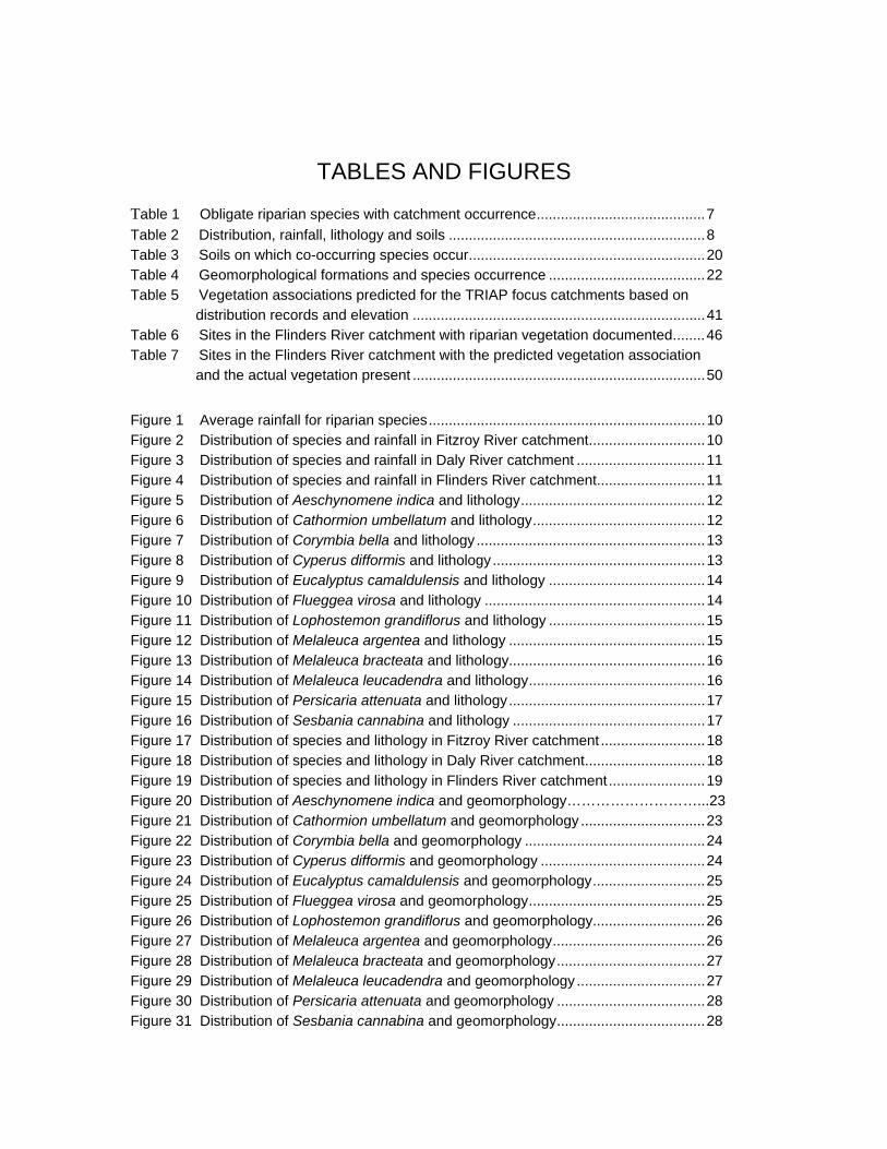
Table 1 Obligate riparian species with catchment occurrence..........................................7 Table 2 Distribution, rainfall, lithology and soils ................................................................8 Table 3 Soils on which co-occurring species occur...........................................................20 Table 4 Geomorphological formations and species occurrence .......................................22 Table 5 Vegetation associations predicted for the TRIAP focus catchments based on
distribution records and elevation .........................................................................41 Table 6 Sites in the Flinders River catchment with riparian vegetation documented........46 Table 7 Sites in the Flinders River catchment with the predicted vegetation association and the actual vegetation present .........................................................................50
Figure 1 Average rainfall for riparian species.....................................................................10 Figure 2 Distribution of species and rainfall in Fitzroy River catchment.............................10 Figure 3 Distribution of species and rainfall in Daly River catchment ................................11 Figure 4 Distribution of species and rainfall in Flinders River catchment...........................11 Figure 5 Distribution of Aeschynomene indica and lithology..............................................12 Figure 6 Distribution of Cathormion umbellatum and lithology...........................................12 Figure 7 Distribution of Corymbia bella and lithology .........................................................13 Figure 8 Distribution of Cyperus difformis and lithology.....................................................13 Figure 9 Distribution of Eucalyptus camaldulensis and lithology .......................................14 Figure 10 Distribution of Flueggea virosa and lithology .......................................................14 Figure 11 Distribution of Lophostemon grandiflorus and lithology .......................................15 Figure 12 Distribution of Melaleuca argentea and lithology .................................................15 Figure 13 Distribution of Melaleuca bracteata and lithology.................................................16 Figure 14 Distribution of Melaleuca leucadendra and lithology............................................16 Figure 15 Distribution of Persicaria attenuata and lithology.................................................17 Figure 16 Distribution of Sesbania cannabina and lithology ................................................17 Figure 17 Distribution of species and lithology in Fitzroy River catchment ..........................18 Figure 18 Distribution of species and lithology in Daly River catchment..............................18 Figure 19 Distribution of species and lithology in Flinders River catchment........................19 Figure 20 Distribution of Aeschynomene indica and geomorphology………………………...23 Figure 21 Distribution of Cathormion umbellatum and geomorphology ...............................23 Figure 22 Distribution of Corymbia bella and geomorphology .............................................24 Figure 23 Distribution of Cyperus difformis and geomorphology .........................................24 Figure 24 Distribution of Eucalyptus camaldulensis and geomorphology............................25 Figure 25 Distribution of Flueggea virosa and geomorphology............................................25 Figure 26 Distribution of Lophostemon grandiflorus and geomorphology............................26 Figure 27 Distribution of Melaleuca argentea and geomorphology......................................26 Figure 28 Distribution of Melaleuca bracteata and geomorphology.....................................27 Figure 29 Distribution of Melaleuca leucadendra and geomorphology ................................27 Figure 30 Distribution of Persicaria attenuata and geomorphology .....................................28 Figure 31 Distribution of Sesbania cannabina and geomorphology.....................................28
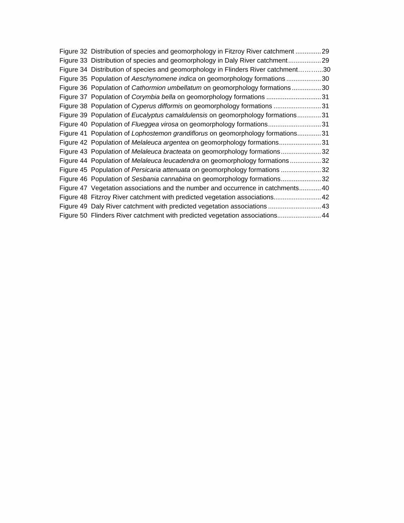
Figure 32 Distribution of species and geomorphology in Fitzroy River catchment ..............29 Figure 33 Distribution of species and geomorphology in Daly River catchment..................29 Figure 34 Distribution of species and geomorphology in Flinders River catchment………...30 Figure 35 Population of Aeschynomene indica on geomorphology formations ...................30 Figure 36 Population of Cathormion umbellatum on geomorphology formations ................30 Figure 37 Population of Corymbia bella on geomorphology formations ..............................31 Figure 38 Population of Cyperus difformis on geomorphology formations ..........................31 Figure 39 Population of Eucalyptus camaldulensis on geomorphology formations.............31 Figure 40 Population of Flueggea virosa on geomorphology formations.............................31 Figure 41 Population of Lophostemon grandiflorus on geomorphology formations.............31 Figure 42 Population of Melaleuca argentea on geomorphology formations.......................31 Figure 43 Population of Melaleuca bracteata on geomorphology formations......................32 Figure 44 Population of Melaleuca leucadendra on geomorphology formations .................32 Figure 45 Population of Persicaria attenuata on geomorphology formations ......................32 Figure 46 Population of Sesbania cannabina on geomorphology formations......................32 Figure 47 Vegetation associations and the number and occurrence in catchments............40 Figure 48 Fitzroy River catchment with predicted vegetation associations..........................42 Figure 49 Daly River catchment with predicted vegetation associations .............................43 Figure 50 Flinders River catchment with predicted vegetation associations........................44
TRIAP SP1 – Report 4: Riparian vegetation
National Centre for Tropical Wetland Research 1
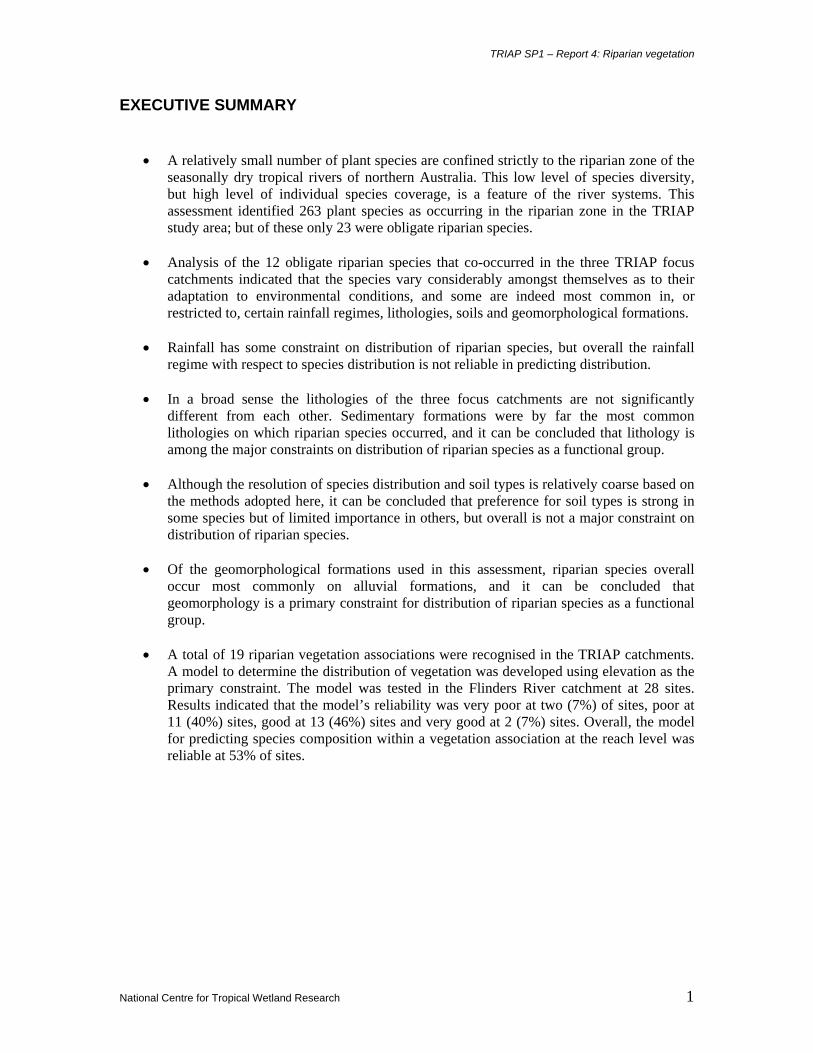
EXECUTIVE SUMMARY
• A relatively small number of plant species are confined strictly to the riparian zone of the seasonally dry tropical rivers of northern Australia. This low level of species diversity, but high level of individual species coverage, is a feature of the river systems. This assessment identified 263 plant species as occurring in the riparian zone in the TRIAP study area; but of these only 23 were obligate riparian species.
• Analysis of the 12 obligate riparian species that co-occurred in the three TRIAP focus
catchments indicated that the species vary considerably amongst themselves as to their adaptation to environmental conditions, and some are indeed most common in, or restricted to, certain rainfall regimes, lithologies, soils and geomorphological formations.
• Rainfall has some constraint on distribution of riparian species, but overall the rainfall
regime with respect to species distribution is not reliable in predicting distribution.
• In a broad sense the lithologies of the three focus catchments are not significantly different from each other. Sedimentary formations were by far the most common lithologies on which riparian species occurred, and it can be concluded that lithology is among the major constraints on distribution of riparian species as a functional group.
• Although the resolution of species distribution and soil types is relatively coarse based on
the methods adopted here, it can be concluded that preference for soil types is strong in some species but of limited importance in others, but overall is not a major constraint on distribution of riparian species.
• Of the geomorphological formations used in this assessment, riparian species overall
occur most commonly on alluvial formations, and it can be concluded that geomorphology is a primary constraint for distribution of riparian species as a functional group.
• A total of 19 riparian vegetation associations were recognised in the TRIAP catchments.
A model to determine the distribution of vegetation was developed using elevation as the primary constraint. The model was tested in the Flinders River catchment at 28 sites. Results indicated that the model’s reliability was very poor at two (7%) of sites, poor at 11 (40%) sites, good at 13 (46%) sites and very good at 2 (7%) sites. Overall, the model for predicting species composition within a vegetation association at the reach level was reliable at 53% of sites.
TRIAP SP1 – Report 4: Riparian vegetation
National Centre for Tropical Wetland Research 2
GLOSSARY facultative riparian species: plants that occur in the riparian zone, but are more common in other
habitats.
freshwater aquatic species: plants that occur in freshwater systems, in either moving or free-
standing water, and spend most of their life cycle in water, but does include species that can
withstand periodic drying.
mangrove species: species that occur in saltwater or brackish water environments, fringing rivers,
estuarine areas and coastal areas.
obligate riparian species: plants that occur exclusively in the riparian zones associated with
creeks, rivers, lakes or lagoons.
TRIAP SP1 – Report 4: Riparian vegetation
National Centre for Tropical Wetland Research 3
1 INTRODUCTION
Inventories and assessments of the riparian vegetation of the rivers and watercourses in northern
Australia are contained in a number of unrelated or limited focus reports, papers, articles, and
other literature. Broad-scale vegetation assessment and mapping has been undertaken across this
area (Beadle 1981; Coles 1986; DPI 1993; ANCA 1996; Sattler & Williams 1999; EPA 2001),
but with varying degrees of resolution and detail with relationship to distribution, species
composition and ecological preferences of riparian vegetation.
The study of the vegetation of the riparian zone, treated as a distinct functional/floristic group of
species, has not been attempted for most of northern Australia. The ecology of some species is
relatively well known, but very little research has been applied to the majority of species that
occur in the riparian zone. Therefore, we are largely ignorant of the effects of environmental
pressures, both natural and anthropogenic, on most riparian species in northern Australia. This
lack of research in northern Australia contrasts with that which has been undertaken in parts of
southeastern Australia, such as the Murray/Darling system, where research on the function and
ecology of much of the riparian vegetation has been relatively more intense.
This report aims to collate, evaluate and analyse the available distribution data for riparian plant
species in the broad context of Australia’s northern tropical rivers, and with subsequent focus on
the three TRIAP focus catchments, Fitzroy R. (WA), Daly R. (NT) and Flinders R. (Qld), to
determine ecological attributes and preferences of the species with relation to rainfall, lithology,
soils, geomorphology, and to determine patterns of distribution.
TRIAP SP1 – Report 4: Riparian vegetation
National Centre for Tropical Wetland Research 4
2 METHODS
A preliminary search to identify riparian species that occur within the Tropical Rivers Project
coverage was conducted using a very broad range of literature (Perry & Lazarides 1964; Story
The list of species generated from these searches were subsequently categorised as follows, based
on the available data:
• obligate riparian species: occurring in no other habitats except those within the riparian
zone
• facultative riparian species: occurring in the riparian zone but also in non-riparian
habitats
• aquatic species
• mangrove species
For the obligate riparian species, distribution data were sought and obtained from the following
sources:
1. Australian Centre for Tropical Freshwater Research (ACTFR)
2. Australian National Botanic Garden Herbarium (CANB)
3. CSIRO Herbarium, Atherton (QRS)
4. National Herbarium of New South Wales (NSW)
5. National Herbarium of Victoria (MEL)
6. Northern Territory Herbarium (DNA)
7. Queensland Herbarium (BRI)
8. South Australian Herbarium (AD)
9. Tropical Biology Herbarium, James Cook University (JCT)
10. Western Australian Herbarium (PERTH)
The distribution data were converted to be compatible with the mapping programs being used in
the broader TRIAP project. Data were converted to degrees and decimalised minutes. Some data
were received without precise geographical location, and an estimate of location was made from
the available information. The rationalisation of data was achieved manually in most cases. From
the list of obligate riparian species, those that were common to the three TRIAP focus catchments
TRIAP SP1 – Report 4: Riparian vegetation
National Centre for Tropical Wetland Research 5
were identified and isolated for more detailed assessment. The location of each species was
overlaid with data on rainfall (BOM 2003), lithology (AGSO 1998), soils (BRS 1991), and
geomorphology (adapted from Erskine et al. 2005), and an assessment of the ecological
preference for each species was developed.
Maps were generated based on species distribution with regards to rainfall, lithology, and
geomorphology, using either the entire TRIAP area or limited to the three focus catchments.
Additional data based on soils were also generated, but as the resolution of soil distribution was
too coarse to utilise, no maps of species distribution and soil distribution were able to be
produced. Analysis of data explained preferences and abundance of species on different lithology
and geomorphology formations, and a summary of environmental preference data was provided
for the 12 species that co-occur in the three focus catchments.
In addition to investigating the distribution and ecology of individual species, patterns of species
associations [herein termed vegetation associations] were determined. Within each TRIAP
catchment, the dominant functional species were ascertained. Where co-distribution of species
occurred, within catchments, vegetation associations were able to be established. With the
establishment of vegetation associations, a model to predict the overall distribution of vegetation
associations was developed. This predictive model attempted to align the established vegetation
associations with environmental attributes. As species distribution data were scant or absent from
some catchments, vegetation associations were only developed to an adequate level in the three
focus catchments, where species distribution data were available. The vegetation associations
were plotted onto maps of the three TRIAP focus catchments.
As a means to test the reliability of the predicted distribution of the vegetation associations, sites
in the Flinders River catchment were visited and the actual distribution of the species within the
established vegetation associations was documented. For this activity, full details of methodology
and results are presented separately below. A reliability rating was provided for sites in the
Flinders River catchment, the assumption being that the level of predictability of the distribution
of the vegetation associations attained there would be similar for the other two focus catchments.
TRIAP SP1 – Report 4: Riparian vegetation
National Centre for Tropical Wetland Research 6
3 RESULTS A total of 264 species was recognised as occurring in the riparian zone in the TRIAP project area
(Appendix 1). Cautiously, this figure may be a considerable under-estimate of the total number of
species that may occur in the riparian zone, as many herbs and shrubs with isolated distribution
and of ephemeral seasonal appearance may not be detected by traditional plant collecting
methods. The actual number of species may well be more than double the number presented here.
However, of the presently recognized total, 23 species were identified as obligate riparian species
[i.e. occurring in no other habitats except the riparian zone]; 126 as facultative riparian species
[occurring in the riparian zone but also in non-riparian habitats]; 84 as freshwater aquatic species;
and 28 as mangrove species (Appendix 1).
For the 23 obligate riparian species, distribution data from about 5800 herbarium accessions were
obtained from ten herbaria, and the data made compatible with the mapping programs being used
for the TRIAP project.
Of the 23 obligate riparian species, 12 species were found to co-occur in the three focus
catchments (Table 1). Data on the numbers of distribution records within the focus catchments,
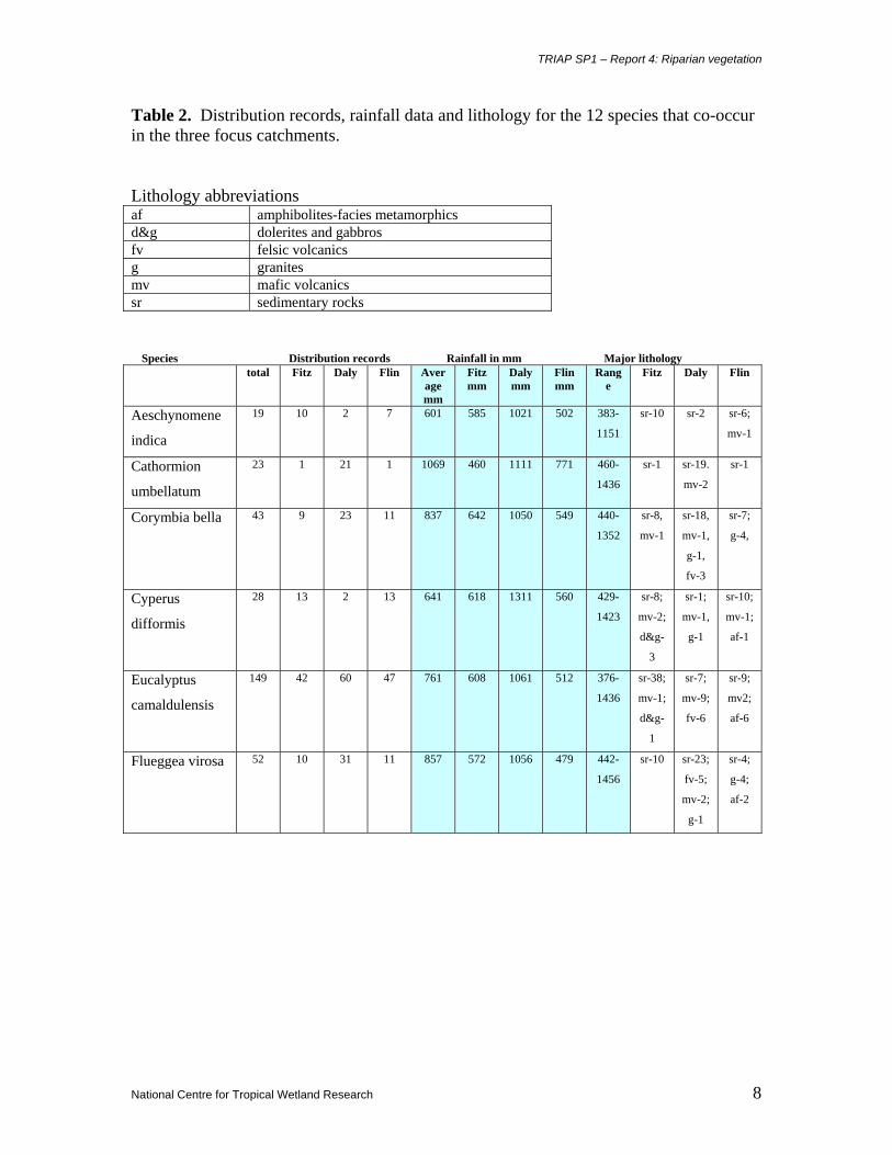
rainfall and lithology for the 12 co-occurring species are presented in Table 2.
The average annual rainfall for the 12 co-occurring species is presented in Fig. 1 and all co-
occurring species plotted on rainfall maps in the three focus catchments are presented in Figs 2-4.
Distribution of the 12 co-occurring species relevant to lithology is presented in Figs 5-16 and all
co-occurring species, plotted on lithology of the three focus catchments, are presented in Figs 17-
19.
The soils on which the co-occurring species occur are presented in Table 3 and geomorphology in
Table 4. Distribution of the 12 co-occurring species relevant to geomorphology is presented in
Figs 20-31, and all co-occurring species, plotted on geomorphology of the three focus
catchments, are presented in Figs 32-34. Graphs presenting the allocation of the 12 co-occurring
species to the five geomorphological formations are presented in Figs 35-46.
TRIAP SP1 – Report 4: Riparian vegetation
National Centre for Tropical Wetland Research 7
Table 1. Obligate riparian plant species that were mapped from herbarium accession data, with catchment occurrence indicated. Those species (n=12) that co-occur in the three focus catchments are highlighted in bold.
Table 2. Distribution records, rainfall data and lithology for the 12 species that co-occur in the three focus catchments. Lithology abbreviations af amphibolites-facies metamorphics d&g dolerites and gabbros fv felsic volcanics g granites mv mafic volcanics sr sedimentary rocks Species Distribution records Rainfall in mm Major lithology
total Fitz Daly Flin Average mm
Fitz mm
Daly mm
Flin mm
Range
Fitz Daly Flin
Aeschynomene
indica
19 10 2 7 601 585 1021 502 383-
1151
sr-10
sr-2 sr-6;
mv-1
Cathormion
umbellatum
23 1 21 1 1069 460 1111 771 460-
1436
sr-1 sr-19.
mv-2
sr-1
Corymbia bella 43 9 23 11 837 642 1050 549 440-
1352
sr-8,
mv-1
sr-18,
mv-1,
g-1,
fv-3
sr-7;
g-4,
Cyperus
difformis
28 13 2 13 641 618 1311 560 429-
1423
sr-8;
mv-2;
d&g-
3
sr-1;
mv-1,
g-1
sr-10;
mv-1;
af-1
Eucalyptus
camaldulensis
149 42 60 47 761 608 1061 512 376-
1436
sr-38;
mv-1;
d&g-
1
sr-7;
mv-9;
fv-6
sr-9;
mv2;
af-6
Flueggea virosa 52 10 31 11 857 572 1056 479 442-
1456
sr-10 sr-23;
fv-5;
mv-2;
g-1
sr-4;
g-4;
af-2
TRIAP SP1 – Report 4: Riparian vegetation
National Centre for Tropical Wetland Research 9
Table 2 (continued). Species Distribution records Rainfall in mm Major lithology total Fitz Daly Flin Aver
age mm
Fitz mm
Daly mm
Flin mm
Range
Fitz Daly Flin
Lophostemon
grandiflorus
76 10 53 13 934 536 1106 463 414-
1442
sr-9; sr-45;
g-1;
mv-5;
fv-1
sr-1;
g-9;
mv-1;
af-4;
Melaleuca
argentea
82 23 49 10 854 587 1055 484 388-
1240
sr-20;
fv-1;
mv2
sr-32;
g-4;
mv-2
sr-8;
fv-2;
g-2;
mv-1;
af-4;
fm-1
Melaleuca
bracteata
32 13 3 16 594 586 817 558 411-
818
sr-11;
mv-1
mv-3 sr-3;
mv-7;
g-4;
af-3
Melaleuca
leucadendra
35 5 24 6 1000 760 1084 696 495-
1436
sr-4;
mv-1
sr-18;
mv-3;
fv-3
sr-5
Persicaria
attenuata
14 6 6 2 923 674 1313 496 443-
1445
sr-4;
mv-2
sr-4;
mv-2
sr-1;
g-1
Sesbania
cannabina
47 22 13 12 699 619 998 462 383-
1436
sr-9;
mv-1
sr-11;
mv-1;
g-1
sr-20;
mv-1;
g-1;
af-1
TRIAP SP1 – Report 4: Riparian vegetation
National Centre for Tropical Wetland Research 10
0
200
400
600
800
1000
1200
Aesc
hyno
men
ein
dica
Mel
aleu
cabr
acte
ata
Cyp
erus
diffo
rmis
Sesb
ania
cann
abin
a
Euca
lypt
usca
mal
dule
nsis
Cor
ymbi
a be
lla
Mel
aleu
caar
gent
ea
Flue
ggea
viro
sa
Pers
icar
iaat
tenu
ata
Loph
oste
mon
gran
diflo
rus
Mel
aleu
cale
ucad
endr
a
Cat
horm
ion
umbe
llatu
m
Figure 1. Average annual rainfall for the 12 species of riparian plants that co-occur in the TRIAP focus catchments.
Figure 2. Distribution of 12 co-occurring species and rainfall in the Fitzroy River catchment.
TRIAP SP1 – Report 4: Riparian vegetation
National Centre for Tropical Wetland Research 11
Figure 3. Distribution of 12 co-occurring species and rainfall in the Daly River catchment.
Figure 4. Distribution of 12 co-occurring species and rainfall in the Flinders River catchment.
TRIAP SP1 – Report 4: Riparian vegetation
National Centre for Tropical Wetland Research 12
Figure 5. Distribution of Aeschynomene indica and lithology in the TRIAP study area.
Figure 6. Distribution of Cathormion umbellatum and lithology in the TRIAP study area.
TRIAP SP1 – Report 4: Riparian vegetation
National Centre for Tropical Wetland Research 13
Figure 7. Distribution of Corymbia bella and lithology in the TRIAP study area.
Figure 8. Distribution of Cyperus difformis and lithology in the TRIAP study area.
TRIAP SP1 – Report 4: Riparian vegetation
National Centre for Tropical Wetland Research 14
Figure 9. Distribution of Eucalyptus camaldulensis and lithology in the TRIAP study area.
Figure 10. Distribution of Flueggea virosa and lithology in the TRIAP study area.
TRIAP SP1 – Report 4: Riparian vegetation
National Centre for Tropical Wetland Research 15
Figure 11. Distribution of Lophostemon grandiflorus and lithology in the TRIAP study area.
Figure 12. Distribution of Melaleuca argentea and lithology in the TRIAP study area.
TRIAP SP1 – Report 4: Riparian vegetation
National Centre for Tropical Wetland Research 16
Figure 13. Distribution of Melaleuca bracteata and lithology in the TRIAP study area.
Figure 14. Distribution of Melaleuca leucadendra and lithology in the TRIAP study area.
TRIAP SP1 – Report 4: Riparian vegetation
National Centre for Tropical Wetland Research 17
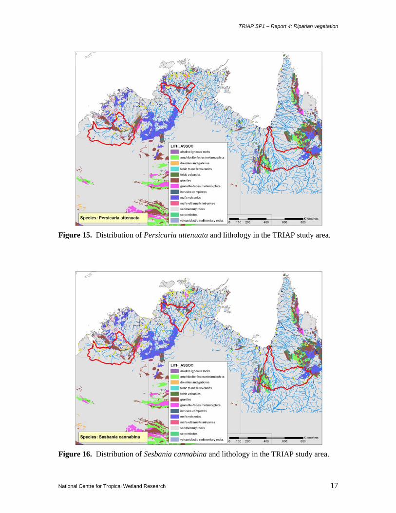
Figure 15. Distribution of Persicaria attenuata and lithology in the TRIAP study area.
Figure 16. Distribution of Sesbania cannabina and lithology in the TRIAP study area.
TRIAP SP1 – Report 4: Riparian vegetation
National Centre for Tropical Wetland Research 18
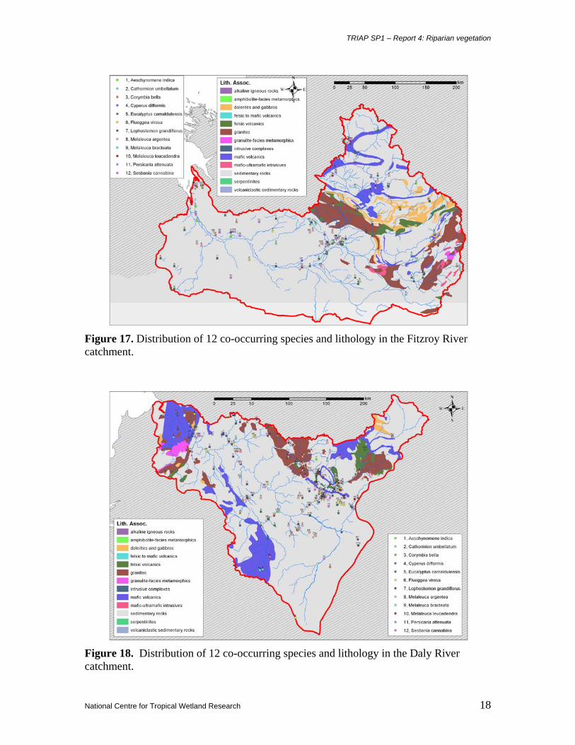
Figure 17. Distribution of 12 co-occurring species and lithology in the Fitzroy River catchment.
Figure 18. Distribution of 12 co-occurring species and lithology in the Daly River catchment.
TRIAP SP1 – Report 4: Riparian vegetation
National Centre for Tropical Wetland Research 19
Figure 19. Distribution of 12 co-occurring species and lithology in the Flinders River catchment.
TRIAP SP1 – Report 4: Riparian vegetation
National Centre for Tropical Wetland Research 20
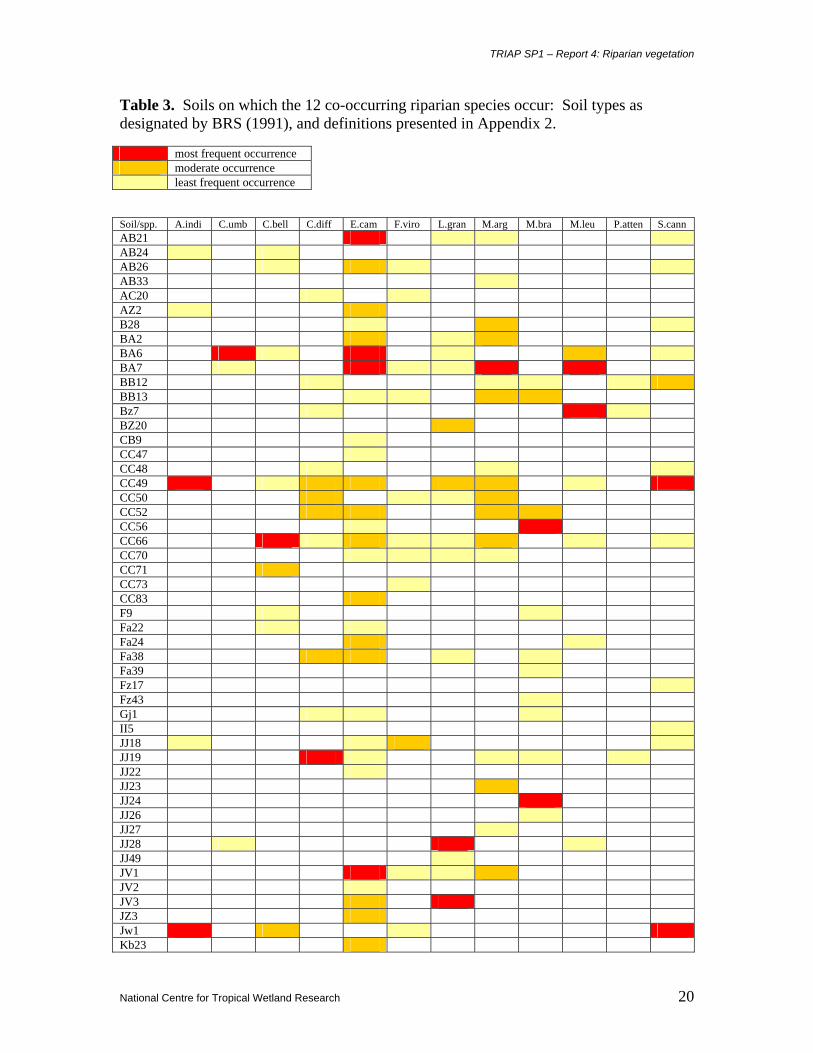
Table 3. Soils on which the 12 co-occurring riparian species occur: Soil types as designated by BRS (1991), and definitions presented in Appendix 2. most frequent occurrence moderate occurrence least frequent occurrence Soil/spp. A.indi C.umb C.bell C.diff E.cam F.viro L.gran M.arg M.bra M.leu P.atten S.cann AB21 AB24 AB26 AB33 AC20 AZ2 B28 BA2 BA6 BA7 BB12 BB13 Bz7 BZ20 CB9 CC47 CC48 CC49 CC50 CC52 CC56 CC66 CC70 CC71 CC73 CC83 F9 Fa22 Fa24 Fa38 Fa39 Fz17 Fz43 Gj1 II5 JJ18 JJ19 JJ22 JJ23 JJ24 JJ26 JJ27 JJ28 JJ49 JV1 JV2 JV3 JZ3 Jw1 Kb23
Table 4. Geomorphological formations on which the 12 co-occurring riparian plant species occur in the focus catchments, represented by percentage of records. Species/geomorphology Alluvial Bedrock
channel Bedrock confined
Estuarine Lake/swamp
Aeschynomene indica 79.2 8.3 8.3 0 4.2
Cathormion umbellatum 39.3 7.1 7.1 7.1 39.3
Corymbia bella 65 12.5 5 0 17.5
Cyperus difformis 52.6 21.1 23.7 0 2.6
Eucalyptus camaldulensis 52.8 19 17.6 0 10.6
Flueggea virosa 55 5 25 0 15
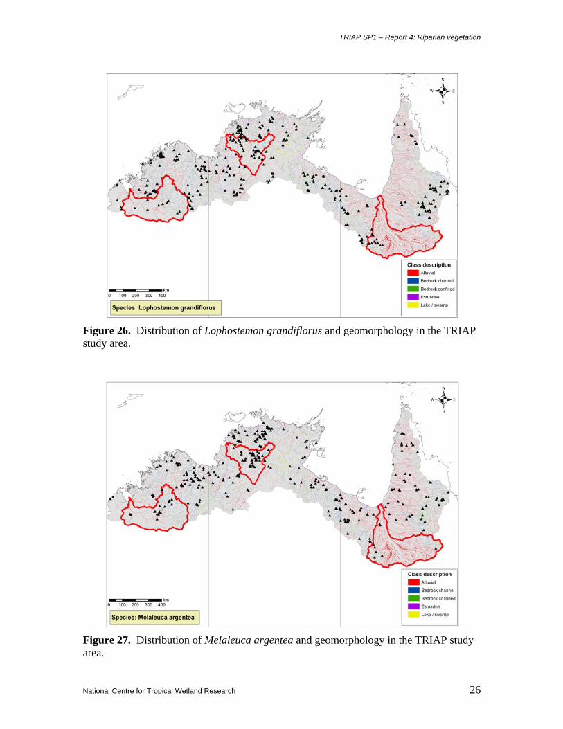
Lophostemon grandiflorus 66.7 8.3 8.3 0 16.7
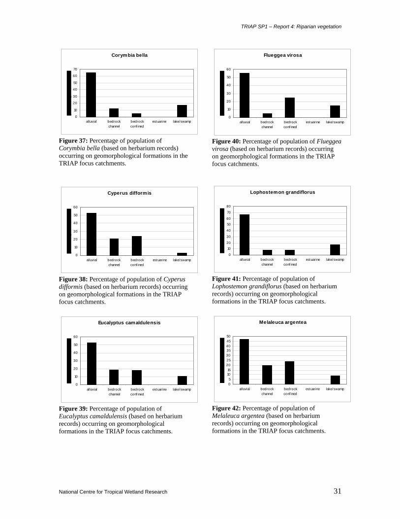
Melaleuca argentea 47 20 24 0 9
Melaleuca bracteata 33.3 54.2 12.5 0 0
Melaleuca leucadendra 31.6 28.9 18.4 0 21.1
Persicaria attenuata 35 25 20 0 20
Sesbania cannabina 61.9 7.1 28.6 0 2.4
• Alluvial (mean 51.6%): Aeschynomene indica (79.2% of records); Lophostemon
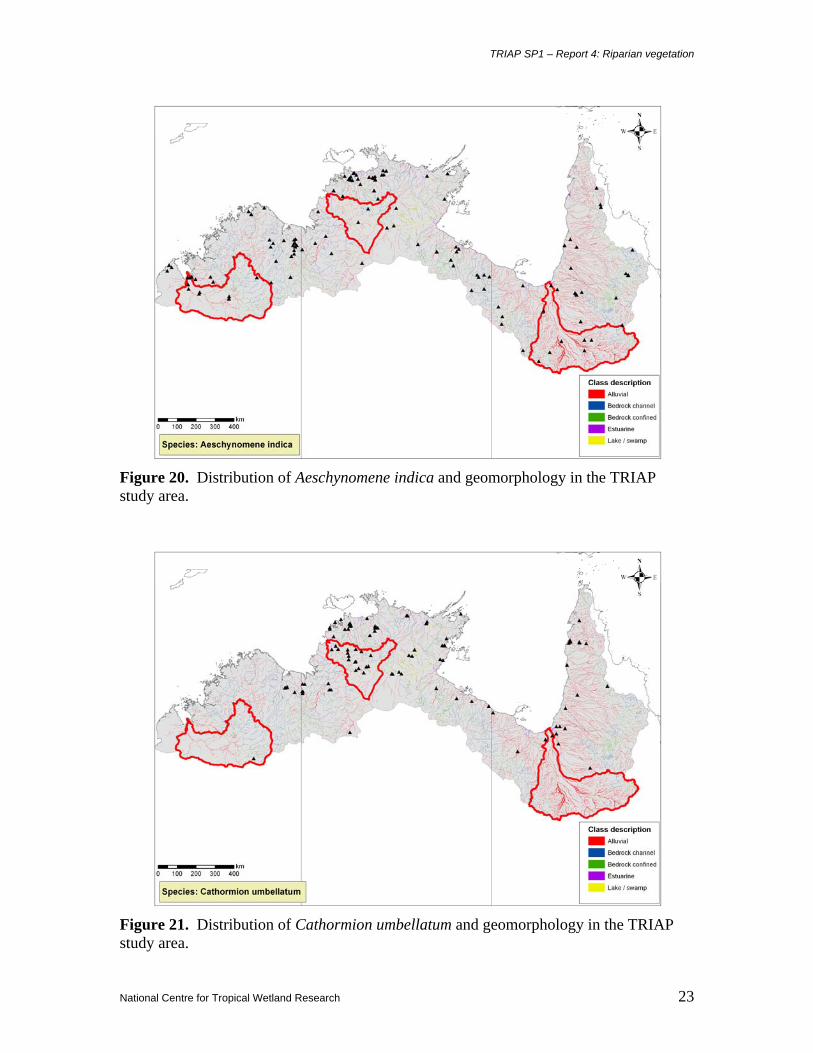
Figure 20. Distribution of Aeschynomene indica and geomorphology in the TRIAP study area.
Figure 21. Distribution of Cathormion umbellatum and geomorphology in the TRIAP study area.
TRIAP SP1 – Report 4: Riparian vegetation
National Centre for Tropical Wetland Research 24
Figure 22. Distribution of Corymbia bella and geomorphology in the TRIAP study area.
Figure 23. Distribution of Cyperus difformis and geomorphology in the TRIAP study area.
TRIAP SP1 – Report 4: Riparian vegetation
National Centre for Tropical Wetland Research 25
Figure 24. Distribution of Eucalyptus camaldulensis and geomorphology in the TRIAP study area.
Figure 25. Distribution of Flueggea virosa and geomorphology in the TRIAP study area.
TRIAP SP1 – Report 4: Riparian vegetation
National Centre for Tropical Wetland Research 26
Figure 26. Distribution of Lophostemon grandiflorus and geomorphology in the TRIAP study area.
Figure 27. Distribution of Melaleuca argentea and geomorphology in the TRIAP study area.
TRIAP SP1 – Report 4: Riparian vegetation
National Centre for Tropical Wetland Research 27
Figure 28. Distribution of Melaleuca bracteata and geomorphology in the TRIAP study area.
Figure 29. Distribution of Melaleuca leucadendra and geomorphology in the TRIAP study area.
TRIAP SP1 – Report 4: Riparian vegetation
National Centre for Tropical Wetland Research 28
Figure 30. Distribution of Persicaria attenuata and geomorphology in the TRIAP study area.
Figure 31. Distribution of Sesbania cannabina and geomorphology in the TRIAP study area.
TRIAP SP1 – Report 4: Riparian vegetation
National Centre for Tropical Wetland Research 29
Figure 32. Distribution of the 12 co-occurring species and geomorphology in the Fitzroy River catchment.
Figure 33. Distribution of the 12 co-occurring species and geomorphology in the Daly River catchment.
TRIAP SP1 – Report 4: Riparian vegetation
National Centre for Tropical Wetland Research 30
Figure 34. Distribution of the 12 co-occurring species and geomorphology in the Flinders River catchment.
Aeschynomene indica
0102030405060708090
alluvial bedrockchannel
bedrockconfined
estuarine lake/swamp
Figure 35: Percentage of population of Aeschynomene indica (based on herbarium records) occurring on geomorphological formations in the TRIAP focus catchments.
Cathormium umbellatum
05
1015
202530354045
alluvial bedrockchannel
bedrockconf ined
estuarine lake/swamp
Figure 36: Percentage of population of Cathormion umbellatum (based on herbarium records) occurring on geomorphological formations in the TRIAP focus catchments.
TRIAP SP1 – Report 4: Riparian vegetation
National Centre for Tropical Wetland Research 31
Corymbia bella
0
10
20
30
40
50
60
70
alluvial bedrockchannel
bedrockconf ined
estuarine lake/swamp
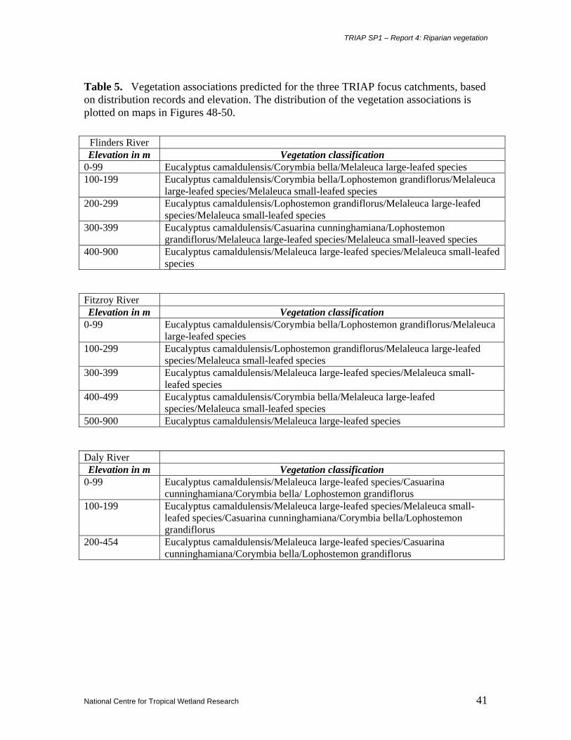
Figure 37: Percentage of population of Corymbia bella (based on herbarium records) occurring on geomorphological formations in the TRIAP focus catchments.
Cyperus difformis
0
10
20
30
40
50
60
alluvial bedrockchannel
bedrockconf ined
estuarine lake/swamp
Figure 38: Percentage of population of Cyperus difformis (based on herbarium records) occurring on geomorphological formations in the TRIAP focus catchments.
Eucalyptus camaldulensis
0
10
20
30
40
50
60
alluvial bedrockchannel
bedrockconf ined
estuarine lake/swamp
Figure 39: Percentage of population of Eucalyptus camaldulensis (based on herbarium records) occurring on geomorphological formations in the TRIAP focus catchments.
Flueggea virosa
0
10
20
30
40
50
60
alluvial bedrockchannel
bedrockconf ined
estuarine lake/swamp
Figure 40: Percentage of population of Flueggea virosa (based on herbarium records) occurring on geomorphological formations in the TRIAP focus catchments.
Lophostemon grandiflorus
0
1020
30
40
5060
70
80
alluvial bedrockchannel
bedrockconf ined
estuarine lake/swamp
Figure 41: Percentage of population of Lophostemon grandiflorus (based on herbarium records) occurring on geomorphological formations in the TRIAP focus catchments.
Melaleuca argentea
05
1015
20253035404550
alluvial bedrockchannel
bedrockconf ined
estuarine lake/swamp
Figure 42: Percentage of population of Melaleuca argentea (based on herbarium records) occurring on geomorphological formations in the TRIAP focus catchments.
TRIAP SP1 – Report 4: Riparian vegetation
National Centre for Tropical Wetland Research 32
Melaleuca bracteata
0
10
20
30
40
50
60
alluvial bedrockchannel
bedrockconfined
estuarine lake/swamp
Figure 43: Percentage of population of Melaleuca bracteata (based on herbarium records) occurring on geomorphological formations in the TRIAP focus catchments.
Melaleuca leucadendra
0
5
10
15
20
25
30
35
alluvial bedrockchannel
bedrockconfined
estuarine lake/swamp
Figure 44: Percentage of population of Melaleuca leucadendra (based on herbarium records) occurring on geomorphological formations in the TRIAP focus catchments.
Persicaria attenuata
05
1015
2025
3035
40
alluvial bedrockchannel
bedrockconfined
estuarine lake/swamp
Figure 45: Percentage of population of Persicaria attenuata (based on herbarium records) occurring on geomorphological formations in the TRIAP focus catchments.
Sesbania cannabina
0
10
20
30
40
50
60
70
alluvial bedrockchannel
bedrockconf ined
estuarine lake/swamp
Figure 46: Percentage of population of Sesbania cannabina (based on herbarium records) occurring on geomorphological formations in the TRIAP focus catchments.
TRIAP SP1 – Report 4: Riparian vegetation
National Centre for Tropical Wetland Research 33
3.1 SUMMARIES OF RIPARIAN SPECIES THAT CO-OCCUR IN THE TRIAP FOCUS CATCHMENTS
3.1.1 Aeschynomene indica L. (Fabaceae) Shrub to 1.5 m tall. Stems hairy, often viscid. Leaf compound, to 14.5 cm long; leaflets in 19-40
pairs, oblong, to 9 mm long, 2.6 mm wide, one main nerve, margin entire or sparsely serrulate.
Inflorescence axillary or terminal, to 4 cm long. Corolla yellow, orange-red in centre, standard
obovate. Pod to 45 mm long, pale brown, sparsely hairy; segments verrucose over seeds. Seeds
dark brown to black, to 4 mm long, 3 mm wide.
Distribution and environmental preferences:
Widespread in most parts of tropical and arid Australia, except Victoria and Tasmania, otherwise
pan-tropical and with closest relatives in South America. In the TRIAP region collections are
remarkable evenly spread, but with some preference for areas away from the coast then inland
throughout the catchments of most systems. The species tends to occur in drier areas, rainfall
range 383-1151 mm per annum, with average rainfall at all recorded sites of 601 mm per annum.
However, collections from the Daly Catchment (2 only) occur in high rainfall zones. Lithological
preference is for sedimentary rocks in active floodplains and low lying coastal plains, and soils
are predominantly grey-brown, saline and brown cracking clays. Geomorphological preference is
predominantly for alluvial formations (79.2% of records), and secondarily for bedrock channel
and bedrock confined (8.3% each), and lake/swamp (4.2%) formations.
3.1.2 Cathormion umbellatum (Vahl) Kosterm. var. moniliforme (DC.) Brummitt (Mimosaceae) Shrub or tree to 10 m tall. Bark dark grey to black, forming plates. Leaf compound, to 9.3 cm
long, leaflets in 1-3 pairs; leaflets obovate to elliptic, to 43 mm long, 27 mm wide, shiny above,
dull to hairy below. Inflorescence axillary or rarely terminal, a many-flowered umbel, to 5 cm
long. Calyx cylindrical, toothed, corolla deeply lobed to 5 mm long; stamens numerous to 12 mm
long. Pods to 17 cm long, 2.5 cm wide, dark or rusty velvet. Seeds dark brown, oblong, to 12 mm
long, 10 mm wide.
Distribution and environmental preferences: Widespread in coastal northern Australia, and
also in Asia. In the TRIAP region collections are widespread, but with some preference for areas
near the coast, particularly in the Gulf of Carpentaria and Top End areas. The species tends to
occur in areas of relatively high rainfall, ranging 460-1436 mm per annum, with average rainfall
at all recorded sites of 1069 mm per annum. There is a concentration of collections in the Daly
River catchment [21 of the 23 focus catchment collections]. Lithological preference is for
sedimentary rocks in flood plains and flat undulating plains, and soils are predominantly grey
TRIAP SP1 – Report 4: Riparian vegetation
National Centre for Tropical Wetland Research 34
clays and sandstone, limestone, shale and slate based. Geomorphological preference is equally
predominant for alluvial and lake/swamp formations (39.3% of records), and secondarily for
bedrock channel, bedrock confined and estuarine (7.1% each) formations.
3.1.3 Corymbia bella K.D.Hill & L.A.S.Johnson (Myrtaceae) Tree to 30 m tall. Bark smooth, white, shedding in thin scales. Leaves (adult) disjunct,
concolorous, linear to lanceolate, acuminate, 7-22 cm long, 6-25 mm wide; petiole 5-21 mm long;
buds pyriform to clavate, 5-6 mm long, 4-5 mm diameter; calyptra ¼ to ⅓ as long as hypanthium,
patelliform to shallowly hemispherical. Fruit ovoid, 8-11 mm long, 6-9 mm diameter.
Distribution and environmental preferences: Northern Australia. Endemic. In the TRIAP
region collections are evenly spread with no apparent preference for either coastal or inlands
locations. The species tends to occur in relatively wet areas, rainfall range 440-1352 mm per
annum, with average rainfall at all recorded sites of 837 mm per annum. There were greater
numbers of collections in the Daly and Flinders catchments than in the Fitzroy. Lithological
preference is for sedimentary rocks, but also occurs on a variety of other types including mafic
and felsic volcanics, and granites, in alluvial plains and gently sloping terrains, and soils are
predominantly grey-brown cacking clays and sandstone, silkstone and limestone based.
Geomorphological preference is predominantly for alluvial formations (65% of records), and
secondarily for lake/swamp (17.5%), bedrock channel (12.5%) and bedrock confined (5%)
formations.
3.1.4 Cyperus difformis L. (Cyperaceae) Annual sedge to 50 cm tall. Roots reddish. Leaves drooping, 1-4 mm wide. Inflorescence with up
to seven branches, each to 3.5 cm long. Bracts at the base of the inflorescence longer than the
inflorescence. Flowers in roundish clusters, 7-17 mm diameter, spikelets dark coloured.
Distribution and environmental preferences: Widespread throughout Australia [except
Tasmania], also in the Old World tropics. In the TRIAP region collections are scattered but with a
bicentricity based on west/east focii, with some preference for areas away from the coast then
inland throughout the catchments of most systems. The species tends to occur in relatively wetter
areas, rainfall range 429-1423 mm per annum, with average rainfall at all recorded sites of 641
mm per annum. The species is much less common in the Top End and Daly River catchment than
other locations. Lithological preference is for sedimentary rocks in active floodplains and gently
sloping plains, and soils are predominantly basaltic or grey and grey-brown clays.
Geomorphological preference is predominantly for alluvial formations (52.6% of records), and
TRIAP SP1 – Report 4: Riparian vegetation
National Centre for Tropical Wetland Research 35
secondarily for bedrock confined (23.7%), bedrock channel (21.1%) and lake/swamp (2.6%)
formations.
3.1.5 Eucalyptus camaldulensis Dehnh. (Myrtaceae) Tree to 20 m tall. Bark smooth, white to pale grey, shedding in sheets. Leaves (adult) alternate,
smooth, narrow, lanceolate, 10-25 cm long, 1-3.5 cm wide, green on both side, acuminate, finely
veined. Inflorescences in leaf axils. Flowers small, cream, in clusters of 5-10; calyptra
prominently pointed. Fruit cup-shaped, 0.5-0.6 cm long, 0.5-0.7 cm wide, woody, with prominent
protruding triangular valves.
Distribution and environmental preferences: Throughout mainland Australia. Endemic. In the
TRIAP region collections are evenly spread, but with some preference for areas away from the
coast and predominantly inland throughout the catchments of most systems. The species tends to
occur in both the driest and wettest areas within the TRIAP, rainfall range 376-1436 mm per
annum, with average rainfall at all recorded sites of 761 mm per annum. Lithological preference
is for sedimentary rocks but also on granites, mafic and felsic volcanics, amphibolites and
dolerites in undulating and flat plains, and soils are predominantly granitic, sandstone, siltstone
and limestone based, and clays. Geomorphological preference is predominantly for alluvial
formations (52.8% of records), and secondarily for bedrock channel (19%), bedrock confined
(17.6%) and lake/swamp (10.6%) formations.
3.1.6 Flueggea virosa (Willd.) Voigt (Euphorbiaceae) (Phyllanthus virosus Willd.) Dioecious spreading shrub to 2 m tall. Bark smooth, light brown to grey. Leaves simple, alternate,
ovate, smooth, 3.5-8.5 cm long by 2.5-5.5 cm wide, light green above, lighter green below,
venation prominent, apex acuminate. Flowers in small clusters in leaf axils, about 1-2 mm long,
cream. Fruit a globose fleshy berry, 5-8 mm diameter, white at maturity, with 3-4 seeds.
Distribution and environmental preferences: Northern Australia and New Guinea. In the
TRIAP region collections are evenly spread, but with no apparent preference for coastal or inland
locations. The species tends to occur in some of the wettest areas in the TRIAP, rainfall range
442-1456 mm per annum, with average rainfall at all recorded sites of 857 mm per annum.
Lithological preference is for sedimentary rocks as well as granites, felsic and mafic volcanics
and amphibolites in flat, gently sloping and undulating plains, and hilly ranges, and soils are
predominantly sandstone, siltstone, greywacke and limestone based, and loamy red earths.
Geomorphological preference is predominantly for alluvial formations (55% of records), and
TRIAP SP1 – Report 4: Riparian vegetation
National Centre for Tropical Wetland Research 36
secondarily for bedrock confined (25%), lake/swamp (15%) and bedrock channel (5%)
formations.
3.1.7 Lophostemon grandiflorus spp. riparius (Benth.) Peter G.Wilson & J.T.Waterh. (Myrtaceae) (Tristania suaveolens var. grandiflora Benth.) Tree to 18 m tall. Bark rough, hard, dark grey to black, fibrous, finely fissured. Leaves simple,
alternate, smooth or finely hairy, ovate to oblong, tapered to the base, 8-15.5 cm long, 3.5-5 cm
wide, grey green above, paler whitish green below, midrib yellowish, apex rounded. Flowers in
leaf axis, in small clusters on short pedicels, small, greenish cream with feathery stamens, about 1
cm across. Fruit a cup-shaped capsule, 5-8 mm long, 5-10 mm wide, toothed around the rim,
brown at maturity; seeds numerous, fine.
Distribution and environmental preferences: Northern Australia. Endemic. In the TRIAP
region collections are evenly spread, but with some preference for areas away from the coast then
predominantly inland throughout the catchments of most systems. The species tends to occur in
wetter locations, rainfall range 414-1442 mm per annum, with average rainfall at all recorded
sites of 1106 mm per annum. The species is a dominant element in the Daly River catchment.
Lithological preference is for sedimentary rocks and also granites, mafic and felsic volcanics and
amphibolites on floodplains and gently sloping to undulating plains, and soils are predominantly
sandstone, siltstone and limestone based, and grey clays. Geomorphological preference is
predominantly for alluvial formations (66.7% of records), and secondarily for lake/swamp
(16.7%) and bedrock channel and bedrock confined (8.3% each) formations.
3.1.8 Melaleuca argentea W.Fitz. (Myrtaceae) Spreading tree to 20 m tall. Branchlets slender and pendulous. Bark papery, creamy white to grey,
soft, layered. Leaves simple, alternate, 5-14 cm long, 1-2 cm wide, narrow elliptic, tapering to
both ends, silvery silky when young, aging silvery grey green, 3-5 main longitudinal veins, apex
pointed; petiole about 1 cm long. Inflorescences in leaf axils or terminal, cylindrical spikes 5-12
cm long, single or in groups of up to 4. Flowers in clusters along the inflorescence axis, pedicels
very short, cream to greenish cream, 12-15 mm long, stamens numerous. Fruit cup-shaped woody
capsule, pedicel lacking, 2-4 mm long, 2-4 mm wide, clustered along the inflorescence axis, grey
brown when mature; seeds very fine, numerous.
Distribution and environmental preferences: Northern Australia. Endemic. In the TRIAP
region collections are more common in Western Australia and Northern Territory than in
Queensland, and most predominant in the larger river basins. There is a preference for areas away
from the coast, but otherwise is relatively evenly spread throughout most catchments. The
TRIAP SP1 – Report 4: Riparian vegetation
National Centre for Tropical Wetland Research 37
species tends to occur in dry to only moderately wet locations, rainfall range 388-1240 mm per
annum, with average rainfall at all recorded sites of 484 mm per annum. The species is one of the
dominant elements in the Daly River catchment. Lithological preference is for sedimentary rocks
and also felsic and mafic volcanics, granites, and amphibolites in hilly areas and flat to undulating
plains, and soils are predominantly greywacke, sandstone, siltstone and limestone based.
Geomorphological preference is predominantly for alluvial formations (47% of records), and
secondarily for bedrock confined (24%), bedrock channel (20%) and lake/swamp (9%)
formations.
3.1.9 Melaleuca bracteata F.Muell. (Myrtaceae) Shrub or tree to 15 m tall. Bark hard, dark, and fissured. Young branches hairy. Leaves scattered,
narrow ovate to ovate, 5-28 mm long, often twisted, acute to acuminate; petiole absent.
Inflorescences open or dense spikes, terminal or near terminal or in leaf axils. Flowers solitary or
in triads; calyx hemispherical, cup-shaped or globose, 1-2 mm long, 1-2 mm wide, pubescent;
mm long, glabrous; stigma small. Fruit cup-shaped, 2-2.5 mm long, 2.5-3 mm wide; orifice 2-2.5
mm wide.
Distribution and environmental preferences: Widespread throughout central and eastern
mainland Australia, except Victoria, and not in the Top End or far northern Cape York Peninsula.
Endemic. In the TRIAP region collections display a bicentricity in Western Australia and
Queensland, are relatively disjunctly distributed, and with strong preference to the upper reaches
of river systems away from the coast. The species tends to occur in the driest areas within the
catchments, rainfall range 411-818 mm per annum, with average rainfall at all recorded sites of
558 mm per annum. Lithological preference is for sedimentary rocks, mafic volcanics, granites
and amphibolites in gently undulating plains and some mountainous areas, and soils are granite
and basalt based grey-brown clays, stony sandy soils, sandy red earths and loamy red earths.
Geomorphological preference is predominantly for bedrock channel formations (54.2% of
records), and secondarily for alluvial (33.3%) and bedrock confined (12.5%) formations.
3.1.10 Melaleuca leucadendra (L.) L. (Myrtaceae) Spreading tree to 30 m tall. Branchlets slender and pendulous. Bark papery, creamy white to grey,
soft, layered. Leaves simple, alternate, smooth, 7-18.5 cm long, 1-2.5 cm wide, narrow ovate,
widest at or below the middle, tapered to a pointed apex, 5-6 main longitudinal veins; petiole 1-2
cm long. Inflorescences in leaf axils or terminal, cylindrical spikes 7-16 cm long, single or in
groups of up to 3. Flowers in clusters along the inflorescence axis, pedicels very short, white or
TRIAP SP1 – Report 4: Riparian vegetation
National Centre for Tropical Wetland Research 38
cream to greenish cream, 10-15 mm long, stamens numerous. Fruit cup-shaped woody capsule,
pedicel lacking, 3-4 mm long, 3-5 mm wide, clustered along the inflorescence axis, brown when
mature; seeds very fine, numerous.
Distribution and environmental preferences: Northern Australia, New Guinea and the
Moluccas. In the TRIAP region collections are unevenly spread with focii of distribution in the
Gregory River, Alligator Rivers, Daly River and Ord River catchments, but otherwise scattered
and with preference for subcoastal and inland locations. The species tends to occur in the wetter
areas, rainfall range 495-1436 mm per annum, with average rainfall at all recorded sites of
696mm per annum. Lithological preference is for sedimentary rocks, and mafic and felsic
volcanics in gently sloping to undulating terrain, hilly ranges, and floodplains with billabongs,
and soils are greywacke, siltstone, sandstone, and limestone based, and grey clays.
Geomorphological preference is predominantly for alluvial formations (31.6% of records), and
secondarily for bedrock channel (28.9%), lake/swamp (21.1%) and bedrock confined (18.4%)
formations.
3.1.11 Persicaria attenuata (R.Br.) Sojak (Polygonaceae) [Polygonum attenuatum R.Br.] Erect or trailing perennial herb or shrub to 1.5 m tall, with trailing branches to 3 m long, stems
jointed. Leaves simple, narrowly ovate, acuminate, 5-20 cm long, 1.5-4.5 cm wide, both surfaces
densely pubescent; petiole lacking or to no more than 3 cm long. Inflorescence of 2-4 pseudo-
spikes, each 3-13 cm long. Flowers 3-5 mm long, white or greenish. Nut lenticelular, 2.5-3 mm
long, dark reddish brown, shiny.
Distribution and environmental preferences: Throughout most of Australia (except Victoria
and Tasmania), New Guinea and Timor. In the TRIAP region collections are focussed in the
Northern Territory and Western Australia, with preference for coastal lowland locations in the
former, and for inland upland locations in the latter. The species tends to occur in wetter areas,
rainfall range 443-1445 mm per annum, with average rainfall at all recorded sites of 496 mm per
annum. Lithological preference is for sedimentary rocks, mafic volcanics and granites in gently
undulating plains, and soils are predominantly sandstone based. Geomorphological preference is
predominantly for alluvial formations (35% of records), and secondarily for bedrock channel
(25%), and bedrock confined and lake/swamp (20% each) formations.
3.1.12 Sesbania cannabina (Retz.) Pers. (Fabaceae) Annual shrub to 2.5 m tall. Stem erect, with branches to 35 cm long. Leaves compound; leaflets
in 5-36 pairs, discolorous, narrowly oblong, 7-29 mm long, 2-5.5 mm wide; apices acute.
TRIAP SP1 – Report 4: Riparian vegetation
National Centre for Tropical Wetland Research 39
Inflorescences axillary racemes, 1.6 – 8 cm long, with 2-9 flowers; pedicels 3.5-8 mm long; calyx
3-6 mm long; corolla with yellow standard streaked or spotted purple, 9-12 mm long, orbicular.
Pod sessile, to 24 cm long, 2-4 mm wide; seeds 23-40, brown or olivaceous, flattened oblong, 3-
3.2 mm long, 1.6-2 mm wide.
Distribution and environmental preferences: Throughout most of Australia (except Victoria
and Tasmania), and the Old World tropics. In the TRIAP region collections are focussed in
Western Australia and Northern Territory, with preference for inland upland locations in the
former, and for coastal lowland locations in the latter. In Queensland distribution tends to be
either coastal or in the upper reaches of river systems. The species tends to occur in wetter areas,
rainfall range 443-1445 mm per annum, with average rainfall at all recorded sites of 1313 mm per
annum. Lithological preference is for sedimentary rocks, mafic volcanics, granites and
amphibolites in active floodplains, low lying coastal plains, flat to undulating plains, and soils are
sandstone, siltstone and limestone based grey-brown and saline clays. Geomorphological
preference is predominantly for alluvial formations (61.9% of records), and secondarily for
bedrock confined (28.6%), bedrock channel (7.1%) and lake/swamp (2.4%) formations.
3.2 VEGETATION ASSOCIATIONS 3.2.1 Vegetation associations in all catchments Nineteen vegetation associations were recognized in the 51 TRIAP catchments, based on the
methodology described above. This methodology applied narrow parameters to the vegetation
associations, so that many are differentiated on the presence/absence of only a single species,
namely the five most common trees recorded in the riparian zone- Eucalyptus camaldulensis,
Callistemon viminalis, Corymbia bella, Casuarina cunninghamiana and Lophostemon
grandiflorus. Conversely, there are some species, at least designated as part of the functional
group ‘Melaleuca large-leaf species’ (Mmelaleuca leucadendra, M. argentea, M. fluviatilis) that
occur in all 19 vegetation associations. The vegetation associations and the number of catchments
in which they occur are presented in Fig. 47.
3.2.2 Vegetation associations in the focus catchments Vegetation in the three focus catchments was studied in more detail than the non-focus
catchments. The distribution data of the dominant functional tree species were aligned with
environmental data. There were no significant relationships detected between distribution of the
vegetation associations and factors such as rainfall, geomorphology or lithology. However, the
TRIAP SP1 – Report 4: Riparian vegetation
National Centre for Tropical Wetland Research 40
most meaningful relationship was between distribution and elevation, i.e., certain species very
often fell within certain elevational ranges. From these data, a model to predict vegetation
associations on the catchment scale was developed, and presented in Table 5.
Figure 47. Vegetation associations and the number of catchments in which they occur.
TRIAP SP1 – Report 4: Riparian vegetation
National Centre for Tropical Wetland Research 41
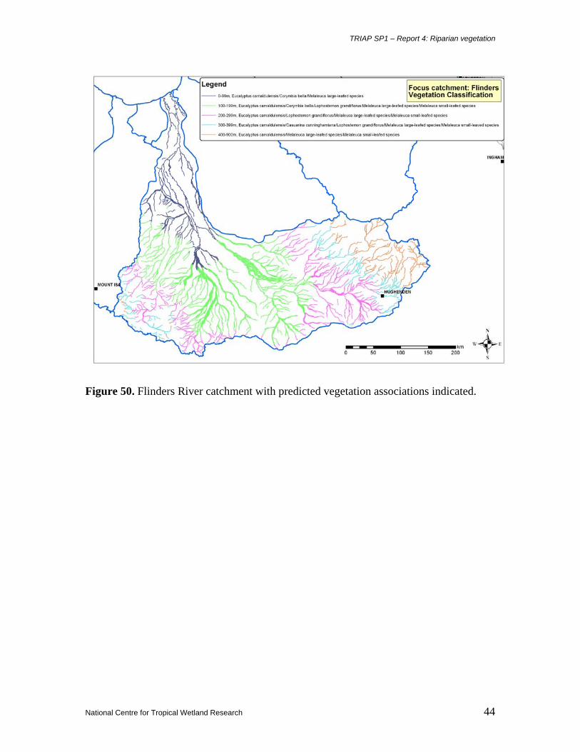
Table 5. Vegetation associations predicted for the three TRIAP focus catchments, based on distribution records and elevation. The distribution of the vegetation associations is plotted on maps in Figures 48-50.
Flinders River Elevation in m Vegetation classification
Figure 48. Fitzroy River catchment with predicted vegetation associations indicated.
TRIAP SP1 – Report 4: Riparian vegetation
National Centre for Tropical Wetland Research 43
Figure 49. Daly River catchment with predicted vegetation associations indicated.
TRIAP SP1 – Report 4: Riparian vegetation
National Centre for Tropical Wetland Research 44
Figure 50. Flinders River catchment with predicted vegetation associations indicated.
TRIAP SP1 – Report 4: Riparian vegetation
National Centre for Tropical Wetland Research 45
3.2.3 Testing the predicted vegetation associations in the Flinders River catchment
Methodology: The composition of the riparian vegetation was studied at 28 sites in the Flinders
River catchment (Table 6). The data obtained allowed comparisons between the predicted
vegetation association and the actual vegetation association at each site. The 28 sites, with the
predicted vegetation association and the actual dominant tree species recorded at the site, are
listed in Table 7.
Results: Of the 28 sites, there were two (7%) that did not contained any of the species within the
predicted vegetation associations. Eleven sites (40%) had a poor relationship, 13 sites (46%) had
a good relationship and two sites (75%) had an very good relationship.
Discussion: From these results, it can be concluded that the method of predicting vegetation
associations is reliable in only 54% of sites within the Flinders River catchment. Whether this
same rate would apply to other catchments is not known.
TRIAP SP1 – Report 4: Riparian vegetation
National Centre for Tropical Wetland Research 46
Table 6. Sites in the Flinders River Catchment where riparian vegetation was documented.
Site GPS position
Betts Ck down S20. 40' 39.1", E144. 05' 04.2" Betts Ck up S20. 40' 45.4", E144. 07' 30.5" Canterbury Ck S20. 42' 15.1", E144. 11' 44.4" Cloncurry R S20. 40' 58.7", E140. 29' 40.4" Corella R S20. 26' 24.0", E140. 19' 00.5" Desolation Ck S20. 32' 18.1", E143. 58' 17.8" Double Barrel Ck S20. 37' 49.3", E143. 04' 00.3" Dugald R S20. 12' 08.8", E140. 14' 14.0" Dutton R S20. 12' 42.3", E144. 19" 03.9" Dutton R homestead S20. 27' 29.1", E143. 46' 50.8" Flinders R S20. 44' 38.4", E143. 40' 58.9" Flinders R Hughenden S20. 45' 25.9", E144. 28' 54.7" Flinders R Maxwellton S20. 38' 34.0", E142. 37' 35.8" Flinders R Nelia S20. 32' 29.1", E142. 15' 18.0" Flinders R Richmond S20. 42' 03.0", E143. 08' 07.8" Fullerton R S20. 37' 42.3", E141. 09' 55.4" Gallah Ck S20. 47' 01.5", E144. 12' 52.1" Gorge Ck S20. 22' 36.4", E144. 24' 51.9" Julia Ck S20. 23' 54.2", E141. 38' 47.2" Pine Tree Ck S20. 01' 52.5", E144. 18' 08.2" Poison Ck S19. 56' 18.2", E144. 15' 59.9" Porcupine Ck S20. 36' 45.1", E144. 24' 11.7' Porcupine Gorge Pyramid S20. 20' 49.6", E144. 27' 36.2" Sawpit Ck S20. 39' 00.6", E143. 41' 12.7" Soda Ck S20. 28' 52.3", E143. 55. 48.4" Spring Valley Ck S20. 35' 31.1", E143. 57' 55.2" Stawell R S20. 25' 38.4", E142. 55' 13.1" Williams R 20. 38' 16.6", E140. 57' 33.3"
TRIAP SP1 – Report 4: Riparian vegetation
National Centre for Tropical Wetland Research 50
Table 7. Sites in the Flinders River catchment, with the predicted vegetation association, the actual vegetation present and a summary of reliability based on number of species in common. Site Predicted vegetation Actual vegetation # sp in
common
Total
# spp
Betts Ck down
E.camaldulensis/L.grandiflorus/ Melaleuca large-leafed species/Melaleuca small-leafed species
E.camaldulensis/Melaleuca
small-leafed species 2 4
Betts Ck up
E.camaldulensis/C.cunninghamiana/ L.grandiflorus/Melaleuca large-leafed species/ Melaleuca small-leaved species
E.camaldulensis/C.bella/L.grandiflorus/Melaleuca large-leafed species/Melaleuca small-leafed species
Melaleuca large-leafed species
1 5
Corella R
E.camaldulensis/C.bella/L.grandiflorus/Melaleuca large-leafed species/Melaleuca small-leafed species
E.camaldulensis/Melaleuca
large-leafed species 2 5
Desolation Ck
E.camaldulensis/L.grandiflorus/Melaleuca large-leafed species/Melaleuca small-leafed species
E.camaldulensis
1 5
Double Barrel Ck
E.camaldulensis/C.bella/L.grandiflorus/Melaleuca large-leafed species/Melaleuca small-leafed species
C.bella
1 5
Dugald R
E.camaldulensis/C.bella/L.grandiflorus/Melaleuca large-leafed species/Melaleuca small-leafed species
E.camaldulensis/Melaleuca
small-leafed species 2 5
Dutton R E.camaldulensis/Melaleuca large-leafed species/Melaleuca small-leafed species
E.camaldulensis 1 5
Dutton R homestead
E.camaldulensis/C.cunninghamiana/L.grandiflorus/Melaleuca large-leafed species/Melaleuca small-leaved species
E.camaldulensis
1 5
Flinders R
E.camaldulensis/L.grandiflorus/Melaleuca large-leafed species/Melaleuca small-leafed species
E.camaldulensis/Melaleuca large-leafed species/Melaleuca small-leafed species 2 5
Flinders R Hughenden
E.camaldulensis/C.cunninghamiana/L.grandiflorus/Melaleuca large-leafed species/Melaleuca small-leaved species
E.camaldulensis
2 5
Flinders R Maxwellton
E.camaldulensis/C.bella/L.grandiflorus/Melaleuca large-leafed species/Melaleuca small-leafed species
E.camaldulensis/Melaleuca large-leafed species
2 5
Flinders R Nelia
E.camaldulensis/C.bella/L.grandiflorus/Melaleuca large-leafed species/Melaleuca small-leafed species
E.camaldulensis/C.bella
3 5
Flinders R Richmond
E.camaldulensis/L.grandiflorus/Melaleuca large-leafed species/Melaleuca small-leafed species
E.camaldulensis/Melaleuca large-leafed species
2 5
Fullerton R
E.camaldulensis/C.bella/L.grandiflorus/Melaleuca large-leafed species/Melaleuca small-leafed species
E.camaldulensis/C.bella
2 5
Gallah Ck
E.camaldulensis/C.cunninghamiana/L.grandiflorus/Melaleuca large-leafed species/Melaleuca small-leaved species
E.camaldulensis/Melaleuca small-leafed species
2 5
TRIAP SP1 – Report 4: Riparian vegetation
National Centre for Tropical Wetland Research 51
Gorge Ck E.camaldulensis/Melaleuca large-leafed species/Melaleuca small-leafed species
E.camaldulensis/Melaleuca small-leafed species 2 3
Julia Ck
E.camaldulensis/C.bella/L.grandiflorus/Melaleuca large-leafed species/Melaleuca small-leafed species
C.bella
1 5
Pine Tree Ck E.camaldulensis/Melaleuca large-leafed species/Melaleuca small-leafed species
E.camaldulensis 1 3
Poison Ck E.camaldulensis/Melaleuca large-leafed species/Melaleuca small-leafed species
0 3
Porcupine Ck
E.camaldulensis/C.cunninghamiana/L.grandiflorus/Melaleuca large-leafed species/Melaleuca small-leaved species
E.camaldulensis
1 5 Porcupine Gorge Pyramid
E.camaldulensis/Melaleuca large-leafed species/Melaleuca small-leafed species
E.camaldulensis/C.cunninghamiana
1 3
Sawpit Ck
E.camaldulensis/L.grandiflorus/Melaleuca large-leafed species/Melaleuca small-leafed species
E.camaldulensis
1 4
Soda Ck
E.camaldulensis/C.cunninghamiana/L.grandiflorus/Melaleuca large-leafed species/Melaleuca small-leaved species
E.camaldulensis
1 5
Spring Valley Ck
E.camaldulensis/L.grandiflorus/Melaleuca large-leafed species/Melaleuca small-leafed species
Melaleuca small-leafed species
1 5
Stawell R
E.camaldulensis/L.grandiflorus/Melaleuca large-leafed species/Melaleuca small-leafed species
E.camaldulensis/Melaleuca large-leafed species
2 4
Williams R
E.camaldulensis/C.bella/L.grandiflorus/Melaleuca large-leafed species/Melaleuca small-leafed species
E.camaldulensis
1 5
TRIAP SP1 – Report 4: Riparian vegetation
National Centre for Tropical Wetland Research 52
4 DISCUSSION
Perhaps the most unusual result of this assessment, based on available data, is the relatively small number of plant species that occur strictly within the riparian zone [here termed obligate riparian species] in the seasonally dry tropical rivers of northern Australia. This assessment contrasts with the greater diversity of riparian vegetation in areas such as the wet regions of northeastern Queensland and Tasmania for example, and also for river systems in seasonally dry climates in South America. If appears that a low level of species diversity, but a high level of individual species coverage, is a feature of the river systems in seasonally dry tropical Australia. Of the 263 species recognized as occurring in the riparian zone in this study, only 23 were obligate riparian species. Of these 23 species, 12 were recorded from all three focus catchments, thus indicating that these at least are widespread species, whilst the remaining 11 have a more restricted distribution. Analysis of the 12 co-occurring species indicated that they indeed vary considerably amongst themselves as to their adaptation to either a broad or narrow range of environmental conditions, and some are indeed most common in, or restricted to, certain rainfall regimes, geomorphological formations and lithologies. For example some species [Cathormion umbellatum, Melaleuca leucadendra, Lophostemon grandiflorus and Persicaria attenuata] are most common in high rainfall areas greater that 900 mm per annum within the catchments, whilst other species [Aeschynomene indica, Melaleuca bracteata and Cyperus difformis] are most common in drier parts with rainfall less than 700 mm per annum. Rainfall has some constraint on distribution of riparian species, but overall the parameters of a rainfall regime with respect to species distribution is not reliable in predicting distribution. In a broad sense, the lithologies of the three focus catchments are not significantly different from each other, although there are some unique associations within each catchment. The distribution of the 12 co-occurring species, in most cases, follows the same or similar lithological associations in each focus catchment, where the lithological association occurs in each catchment. However, where those species that are most commonly distributed on sedimentary rocks occur, there may be rarer lithologies, such as dolerites and gabbros in the Fitzroy catchment and granites in the Daly and Flinders catchments, where the same species may also occur. Sedimentary formations were by far the most common lithologies on which riparian species occurred, which is not unusual considering that these are the primary formations associated with rivers and watercourses. It can be concluded that lithology is among the major constraints on distribution of riparian species. Although the resolution of species distribution and soil types is relatively coarse based on the methods adopted here, some general assessment came be presented. Species varied greatly as to their preference for soil types and adaptability to many soil types. For example, widespread species such as Eucalyptus camaldulensis occurred on 56 soil types and was predominant on 11
TRIAP SP1 – Report 4: Riparian vegetation
National Centre for Tropical Wetland Research 53
of those types; Lophostemon grandiflorus occurred on 32 soils types and predominant on 8 of those types; and Sebania cannabina occurred on 27 soil types and was predominant on six of those types: these are examples of species that occurred on a broad range of soil types and were more or less not largely confined to single or few soil types and therefore categorized as adaptable species. On the other hand, there are some species that, although occurring on many soil types, are strongly associated with a single or few of those types. For example, Corymbia bella occurred on 25 soil types, but was predominant on only four of those types; Cyperus difformis occurred on 20 soil types but was predominant on only a single type; and Persicaria attenuata occurred on 12 soil types but was predominant on only a single type; these are examples of species that have a low level of adaptability to soil types, and a strong preference for a single soil type. It can be concluded that preference for soil types is strong in some species but of limited constraint in others, but overall is not a major constraint on distribution of riparian species. Of the five geomorphological formations used in this assessment, riparian species overall occur most commonly on alluvial formations. However, some species expressed a strong preference for other formations. For example, Melaleuca bracteata was most common on bedrock channel formations; Sesbania cannabina and Flueggea virosa occurred most commonly on bedrock confined sites; and Cathormoin umbellatum with an equal preference for alluvial and lake/swamp formations. Overall, most of the 12 co-occurring species showed a strong preference for a single geomorphological formation, and it can be concluded that geomorphology is a primary constraint for distribution of riparian species. The preliminary nature of this study did not allow for an examination of the distribution of rare or restricted riparian species, but rather provided an assessment of widespread species and in particular those species co-occurring in the three focus catchments. Upon this basis, the similarities of the three focus catchments, not their differences, are highlighted. The research presented here represents base-data upon which further assessment of the riparian vegetation can be undertaken.
TRIAP SP1 – Report 4: Riparian vegetation
National Centre for Tropical Wetland Research 54
5 REFERENCES
AGSO [Australian Geological Survey Organisation] 1998. Geology (National Geoscience Dataset). Australian Geological Survey Organisation, Canberra. ANCA [Australian Nature Conservation Agency] 1996. A Directory of Important Wetlands in Australia, Second Edition. Australian Nature Conservation Agency, Canberra. Beadle, N.C.W. 1981. The Vegetation of Australia. Gustav Fischer Verlag, Stuttgart. BOM [Bureau of Meteorology] 2003. Mean Monthly and Mean Annual Rainfall Data. Australian Government, Melbourne. Bowman, D.M.J.S. 2000. Australian Rainforests: Islands of Green in a Land of Fire. Cambridge University Press, Cambridge. BRS [Bureau of Rural Sciences after Commonwealth Scientific and Industrial Research Organisation] 1991. Digital Atlas of Australian Soils (ARC/INFO vector format). [Online] Available HTML: http://www.brs.gov.au/data/datasets Clifford, H.T. & Specht, R.L. 1986. Tropical Plant Communities: their Resilience, Functioning and Management in Northern Australia. University of Queensland, St Lucia. Cole, M.M. 1986. The Savannas: Biogeography and Geobotany. Academic Press, London. Cowie, I.D., Short, P.S. & Osterkamp Madsen, M. 2000. Floodplain Flora: a Flora of the Coastal Floodplains of the Northern Territory, Australia. Flora of Australia Supplementary Series Number 10. ABRS, Canberra, PWCNT, Darwin. Davis, A. & Dowe, J. 2004. Environmental Survey and Ecological Inventory of the Freshwater Wetland Environments in the Nicholson-Gregory Catchment, North-Western Queensland. ACFTR Report No. 04/10. Australian Centre for Tropical Freshwater Research, Townsville. Dowe, J.L. 2004. A Survey of Dominant Riparian Vegetation at Selected Sites in the Georgetown Area, Northern Gulf Region. ACTFR Report No. 04/13. Australian Centre for Tropical Freshwater Research, Townsville. DPI [Department of Primary Industries]. 1993. The Condition of River Catchments in Queensland. Department of Primary Industries, Brisbane. Erskine, W.D., Saynor, M.J., Erskine, L., Evans, K.G. & Moliere, D.R. 2005. A Preliminary Typology of Australian Tropical Rivers and Implications for Fish Community Ecology. Marine & Freshwater Research 56: 253-267.
TRIAP SP1 – Report 4: Riparian vegetation
National Centre for Tropical Wetland Research 55
Perry, R.A. & Lazarides, M. 1964. Vegetation of the Leichhardt-Gilbert area. In: General report on lands of the Leichhardt-Gilbert area, Queensland, 1953-54, pp. 152-191. Pettit, N.E. & Froend, R.H. 2001. Availability of Seed for Recruitment of Riparian Vegetation: a Ccomparison of a Tropical and a Temperate River Ecosystem in Australia. Australian Journal of Botany 49: 515-528. 2001. Russell-Smith, J. 1995. Flora. In: Press, T., Lea, D., Webb, A. & Graham, A. (eds), Kakadu: Natural and Cultural Heritage and Management, pp. 127-166. ANCA, Darwin & Australian National University, Casuarina. Sattler, P.S. & Williams, R.D. 1999. The Conservation Status of Queensland’s Bioregional Ecosystems. EPA, Brisbane. Start, A.N. & Handasyde, T. 2002. Using Photographs to Document Environmental Change: the Effects of Dams on the Riparian Environment of the Lower Ord River. Australian Journal of Botany 50: 465-480. Stephens, K.M. & Dowling, R.M. 2002. Wetland Plants of Queensland: a Field Guide. CSIRO, Collingwood. Story, R. 1970. Vegetation of the Mitchell-Normanby area. In: Lands of the Mitchell-Normanby area, Queensland, pp. 75-88. CSIRO, Melbourne. Thurgate, M. 1994. Natural Assessment of the Gulf Plains Biogeographic Region. JCU, Townsville.