APPLIED RESEARCH GRANTS FOR DISASTER REDUCTION II A Compenium of Hazard Risk Reduction Working Papers for Latin America and the Caribbean Compiled by University of Wisconsin Disaster Management Center – UWDMC
Transcript
APPLIED RESEARCH GRANTS FOR DISASTER REDUCTION II
A Compeniumof Hazard RiskReductionWorking Papers for LatinAmerica and the Caribbean
Compiled by
University of WisconsinDisaster Management Center – UWDMC
APPLIED RESEARCH GRANTS FOR DISASTER REDUCTION II
A Compendium ofHazard Risk ReductionWorking papers for Latin America and the Caribbean
University of Wisconsin–Disaster Management Center432 North Lake StreetMadison, WI 53706 USA
December 2006
Compiled by
University of WisconsinDisaster Management Center – UWDMC
To explore innovative ways to address human
vulnerability to hazards (natural and human-made),
the ProVention Consortium invited a special disaster
management audience—the world’s youth. The
Consortium launched a Program of Applied Grants
for Disaster Risk Reduction in 2002 and a second
Program in 2005. In the second Program, 55 grants
were awarded worldwide.
The Program is managed by ProVention as a
collaborative initiative with University of Wisconsin
Disaster Management Center (UWDMC), Asian
Disaster Preparedness Center (ADPC), Bangkok,
Thailand and Disaster Mitigation for Sustainable
Livelihoods Programme (DiMP), University of Cape
Town, South Africa. Each academic center provides
oversight of the Program, administers the grants
and guides the research.
Projects from Latin America and the Caribbean
are presented in this Compendium.
This collection of working papers presents current
research on disaster risk reduction issues and practice.
These unedited papers reflect work in progress and
may appear at a later date in other forms.
María Alejandra del Campo
The radio at school: An educational instrument to transmitknowledge and awareness for mitigation of natural risks
Cultural vulnerability, risk perception and communication: towards a community participatory approach for disaster prevention in theMunicipality of Tlatlauquitepec, Sierra Norte de Puebla, Mexico
The project was developed in a secondary schoolthat has its own closed circuit radio, and includedthe production of 16 radio micro programs involv-ing four risks: earthquakes, zonda wind, alluvium,and drought. These micro programs were producedby almost the 30 percent of the student’s popula-tion in workshops with teachers of social communi-cation and all school population listened to them.
In addition, a questionnaire that inquires aboutknowledge on the natural risks chosen was createdand answered by the main population of thestudents in three moments:
1) Before the micro programs were produced and heard
2) Immediately after the micro programs were produced and heard
3) After approximately three and a half months.
This was done to measure the effect on the level ofknowledge.
The result shows that the knowledge on the subjectincreases for most of the questions after the listen-ing to the micro programs. The effect is moresignificant among those that did participate in theproduction of the micro programs and especiallyimmediately after the listening.
Deeper studies and in other schools could be doneto analyze why this increase is not similar for allthe questions and why there was a decrease insome questions.
Project Achievements
• Micro radio programs production was completed.
• The school population did answer aquestionnaire in three moments.
• All micro radio programs were listened.
• Information collected by the questionnaire was processed and results and conclusions were written.
• Dissemination activities were done: – CD compilation of all the programs – Web site creation – Publication of project findings and outputs
Key Activities
Micro radio programs production was completed:The 16 micro radio programs about the naturalrisks chosen: earthquakes, zonda wind, alluviumand drought were produced in workshops bystudents at the Luis Federico Leloir secondary
ARGENTINA
school together with teachers of social communica-tion. Participants were advised by a group ofpsychologists specializing in prevention. Nearly 100pupils, representing almost the 30 per cent of theschool’s student’s population, were involved in theproductions. Pupils had the option to participate inthe workshops that were organized in order toproduce the microprograms, since these were notobligatory and they were carried out after classtime. Each course was in charge of studying andproducing a script about one issue related to themain subject, and some pupils of each coursespoke in the radio programme. The workshopswere divided into 7 principal activities or topics:
1) Radio characteristics
2) Radio genres and formats
3) Elements of radiophonic language
4) Music and broadcasting techniques
5) Microprogramme production
6) Microprogramme recording
7) Microprogramme listening and evaluation of the radio workshop.
The school population did answer a questionnairein three moments: A questionnaire that inquiresknowledge on the natural risks chosen was created.This questionnaire is divided into five sections: the first one, where 3 questions are made aboutgeneral aspects and the other four sections whereeach one is about one of the risks and they have 6 questions per section. The main population of theschool students answered the questionnaire inthree moments:
1) First moment: Before the micro programs wereproduced and listened
2) Second moment: Immediately after the microprograms were produced and listened
3) Third moment: After approximately three and a half months later.
In the last moment only the students that were the previous year did it, new students did notanswer it and the graduated students neither.
All micro radio programs were heard: The microradio programs were listening by all the student ofthe school during break times and free classes. Inorder to motivate the listening a contest wasprepared. The second time the pupils answered thequestionnaire, they voted anonymously the mostcreative programme and the one that had touchedthem most.
In addition, a special event was organized to handin certificates to students that participated in theworkshop as a way of recognizing their work andeffort. Teachers also received certificates. Jointlysome programs were listened during this event.
Information collected by the questionnaire was processed and results and conclusions werewritten: After the questionnaire was answered bythe school’s population in three moments, all theinformation was input in the SPSS (StatisticsProgram for Social Sciences) computer program. All the information processing was done by theresearch assistant and the team leader, as well asthe writing of the results and conclusions.
Dissemination activities were done:
• CD compilation of all the programs: Acompilation was edited and 120 copies weremade to hand them in to the students that did participate in the workshops and to leavesome copies in the school library.
• Web site creation: For this a working plan was organized and the web address is:http://www.laradioenlaescuela.com.ar
• Publication of project findings and outputs: E-mails with a presentation letter, a projectsummary and a picture were sent to local and national newspapers and magazines, toeducational magazines and radio stations. Very few answers were received. One note did appear in a local newspaper
Other supporting activities accomplished to reach the objectives included:
• Meetings in Mendoza with the team, the mentor,the school principal, and a member of the NGO,Psychologists without Frontiers;
• Visits to the school and the radio;
• Bibliographical research to compile specialmaterials about the chosen risks
• Selection of social communication teachers,meetings with them, providing teacher trainingsessions about the risks, and coordinatingworkshops to prepare the microprogrammes;
• Invitation posters to participate in the workshopswere spread all over the school;
• Translation into English of all the materialproduced.
Constraints or Difficulties
No serious obstacles to completing the project wereidentified.
ARGENTINA
2
Opportunities and Discoveries
Although the workshops were no obligatory,almost 30 % of the student’s population didparticipate in them and they really were enthusi-astic. In both groups, those that did participate inthe workshops and those who did not, studentsthink that they know more after they had listenedto the programs. So the feeling of having learnt isgeneral.
Other schools were interested to use the microradio programs as an educational tool and alsothere are some ideas to extend the programs tothe community members.
The project also helps to a better use of the schoolradio for other subjects.
Assessment of Results
Comparing the original work plan with the actualprogress we are on-target. The CD compilationwas done later than what was planned since thechildren had the winter holidays.
The dissemination of Project results will continue;papers will be sent to the list of possible publica-tions annotated in the web.
Project Impact
The project facilitates links between disaster risksreduction and development in developing coun-tries by addressing these elements through learn-ing about how to reduce vulnerability. By workingto learn how to reduce vulnerability which is anelement of risk and raising the awareness aboutthe importance of carrying preventive measures aspart of the preparedness processes, we are work-ing to reduce disaster risk. In this way, develop-ment is enhanced, and the environment ispreserved against the enormous damages disasterscause. In addition, prevention and mitigation aredevelopment functions. The awareness of thenatural risks chosen for the project and knowingabout them help in the preparedness for disasters.A community that is prepared will suffer lessdamages and this is a way of protecting health.
Project sustainability
The idea will be sustainable beyond these 10months, because it could continue with thedisseminating of the project and other activitiesrelated to it can be organize. As the information ofthe samples has more variables than the ones
chosen for the analysis this could be done. Also itcould be carried out in other schools and newprograms could be produced focusing on thesubject and also reduction of technological riskscould be included.
The tape recordings of the microprograms are asustainable practice to introduce in the schoolcurricula material and information about naturalrisks and their mitigation. This practice is cheapand easy to include in developing countriesspecially, where the resources destined for preven-tion is a lot less than the really needed. So, thecompilation of all the microprograms can be offerto other schools or libraries as a consulting mate-rial about natural disaster and risk information.
Depth studies can by carry out about the closedrelationship between risks´ mitigation and radioeducation as an effective strategy to stimulate apreventive culture.
Project ownership
The idea can be carried out not only in the schoolradio closed circuit that has been chosen, but alsoin others. There is no data in the region aboutradio programs in the past decade produced byteenagers for teenagers, and dealing only withnatural risk reduction.
In addition some institutions support this pioneer-ing idea in the province. And this could motivatethe creation of others in the country and aroundthe world, which grows more conscious every dayof the importance education has in disaster andrisks reduction. Using the radio as an educationtool is a new approach to education on thesetopics.
Project learning components The component of learning are for those directly involved in thework: students, social communication’s teachers,the interviewers, the team, the research assistant,the team leader and all the people did participatein the any activity directly. But also for those indirectly involved: the listeners of the commu-nity, the families that have access to the CDcompilation given to the children, and people with access to internet and newspapers.
Appended to this Working Paper are slidespresented at a Regional ProVention Web-Conference in October 2006.
ARGENTINA
3
ARGENTINA
4
ARGENTINA
5
ARGENTINA
6
WEB CT ID
2153COL
PROJECT REPORT
COLOMBIA
7
Analysis of the impact of small and moderatedisasters at local level in Colombia
Local risk analysisSmall scale disasters Local disaster index
Project Summary
The objective of this research has been the evalua-tion of the proneness of Colombia to small scaleand chronic disasters and the type of impact theyhave to the local development and to the countryfrom aggregated point of view. Such analysis havedetected the spatial variability and dispersion ofrisk in the country as result of events that rarelyenter in the international, or even national, disasterdatabases, but which pose a serious and accumula-tive development problem for local areas and, giventheir overall probable impacts, for the country as a whole. The most of these disasters are the resultof socio-natural processes associated with environ-mental deterioration and are associated withpersistent small events such as landslides,avalanches, flooding, storms and also lower scaleearthquakes and volcanic eruptions. The implemen-tation of this research meant the improvement ofDesInventar database (19,202 registers from 1970 to 2002), data analysis and the reformulation of theLocal Disaster Index (of the IDB-IDEA System ofIndicators for Americas) without outliers to detectthe real impact of local disasters. The outcomeswill be useful for economic analysts and sectoraldecision makers, related to the promotion of ruraland urban policy development, because they candetect the persistence and accumulation of effectsof local disasters.
Project Achievements
• Reviewing and improving of DesInventardatabase (local registers in the municipalities).
• Analysis of the information on recurrent disasters at municipal level.
• Evaluation of the Local Disaster Index (local impact or effects) without extreme hazard events; criticisms and recommendationsfor a new approach.
Key Activities
Reviewing and improving of DesInventar data-base. The updating of DesInventar database (developed by Social Network for DisasterPrevention in Latin America—La RED in Spanish)was made taking into account both new input dataas corrections of existing records for the country. Aprocess of refinement was achieved to depurate orreplace the registers with wrong data. A statisticalprocess was developed to eliminate outliers inorder to avoid analytical distortions as result ofextreme hazard events, considering the purpose of
COLOMBIA
the research to evaluate the effects of small andmoderate disasters (recurrent events). A total of19,202 events (registers of effects by municipality)were completed until 2002.
Analysis of the information on recurrent disasters at municipal level. Once the databasewas updated and adjusted the subsequent step was to analyze the information. The objective wasto confirm the relevance of the recurrent smalldisasters as their accumulated impact in compari-son to the extreme events in the country. Theanalysis was made taking into account 32 years(1970-2002) and all municipalities where an inventory of effects has been obtained. Interestingresults and implications for development havebeen detected, considering the dispersion as wellas the persistence of the effects at local level.
Evaluation of the Local Disaster Index withoutextreme hazard events. The Local Disaster Index(LDI) was evaluated without taking into accountthe effects of extreme hazard events to obtain reallocal “disaster” indices. The LDI was developed bythe Institute of Environmental Studies (Instituto deEstudios Ambientales, IDEA in Spanish), of theNational University of Colombia in Manizales, inthe framework of the program of “Indicators onDisaster Risk Management in the Americas”, forthe Inter-American Development Bank (IDB). The results obtained were significantly different.Some recommendations were issued regarding themethodology to improve the approach used in theIDB-IDEA system of indicators, redefining theirPersistence Indices by type of events and changingthe denomination of LDI itself to “Local EffectsIndex” due to it considers the effects of all disasters, both small and frequent as extreme and sporadic.
Constraints or Difficulties
The reviewing and adjustment of DesInventardatabase took more time than foreseen due to the careful verification of the data of each event in each municipality of the country. It was necessary to involve more research assistants from La RED to complete the data collection.
Opportunities and Discoveries
Interest from PREDECAN project (EuropeanUnion) The project on Disaster Prevention ofAndean Community (Prevención de Desastres,PREDECAN), which involves activities in
Colombia, Venezuela, Peru, Ecuador and Bolivia, isinterested in the application of the informationrelated with DesInventar database and the LocalDisaster Index (LDI) based on the new approachproposed in this work. This interest was notknown before the existence of this project and nowthere are many expectations about the results andmethodology.
Interest from National Department of Planning(DNP in Spanish) and the World Bank Theinformation of the database (data of losses in eachmunicipality) could be useful for the categorizationof the municipalities of Colombia by analyzing therisk level and the budget of municipal investmentfor risk management (project in process with thenational government).
Assessment of Results
In the beginning of the project the data collectionand updating had not the expected progressbecause of shortcomings presented in the processof verification of data. The subsequent activitieswere delayed because they would be started oncethe first activity was ended. The duration of thisactivity was longer than expected. Neverthelessduring the second phase this situation wasresolved involving more research assistants. It isreflected in the changes of the budget. Resultshave been such as interesting as they wereexpected in the hypotheses posed.
Project Impact
Disaster risk management is not a discipline,indeed it is a strategy. As strategy it contributes tosustainable development from the social and envi-ronmental management perspective. This projectattempts to illustrate how the frequent small ormoderate disasters entail and increase difficultiesfor the local development. These events, contraryto the extreme and extraordinary disasters, veryoften are not visible at national level and theireffects are not relevant from macro-economicalpoint of view. Small disasters usually affect thelivelihoods of poor people, perpetuating their levelof poverty and human insecurity. Consequently,small and frequent disasters prevent the sustain-ability of local human development. Withoutstability and prosperity the economical and socialdevelopment is not possible and this problemshould be a concern for national and internationalstakeholders. This work claims to take intoaccount not only the extreme events, as it is usual,
COLOMBIA
8
but the small scale disasters in the disaster riskmanagement policies and vulnerability reductionactions.
Project sustainability
As it was proposed, this research has been devel-oped in the framework of the project of “NationalIndicators for Disaster Risk Management” devel-oped by IDEA. The project is a national continua-tion of the program of “Indicators on Disaster RiskManagement in the Americas,” developed for IDBand for the involved countries. The application ofthe research findings are now considered in thenational project and it is expected to be includedin the second phase on the IDB regional program.
On the other hand, in the process of this researchPREDECAN was interested to enhance the applica-tion of the methodology to all countries of theAndean region and agreed to involve La RED inthe updating and maintenance of the DesInventardatabases of the countries for the future applica-tion of the risk indicators at sub-national level.Lastly, DNP with the support of the World Bankalso was interested to use the information for the classification of municipalities of Colombiaaccording to local disaster risk.
Project ownership
As it was abovementioned the research findingshave been useful for the “National Indicators forDisaster Risk Manage ment” and will be consid-ered by the second phase of the “NationalIndicators for Disaster Risk Management”.Therefore the methodologies are a contribution for two important national and international institutional initiatives. In addition, DNP, La REDand PREDECAN will give use of this results andmethodologies. The second phase of the IDB-IDEAindicators program will include the socialization ofresults and dialogues with the stakeholders of thecountries, therefore it will the channel to dissemi-nate the results in Colombia and the future similarapplications in other countries.
In general, the results of the research analyses are fundamental for criteria definition that willsupport decision making in matter not only of risk management but also territorial planning,
determination of land use, environment protec-tion, designing of social and sectoral development,and risk transfer strategies.
Project learning components
Within the results obtained in this study it ispossible to emphasize and demystify that extremedisasters are not necessarily which determine thehistory of disasters in the countries. Until now, in the case of Colombia, this history has beendominated by big disasters. Nevertheless andaccepting the relevance of their effects on thepopulation and the economy of the country as awhole, also it is necessary to recognize that eachyear an important number of small and moderateevents, non very spectacular in terms of damageand losses in individual way, certainly do affectthe population and the diverse economic sectorsas result of their frequency and their impact accu-mulation over time.
Likewise, the implementation of an innovativeLocal Disaster Index (LDI by IDEA for the IDB) or the Local Effects Index (LEI), proposed by theauthor as an alternative with a subtle variation,reveals and measures the susceptibility of thecountries of the Americas to small scale andrecurrent disasters. They illustrate that the accumulative impact may be highly significant atthe local level and, consequently, to the nationallevel from social point of view. The outcomes ofthis type of analysis can be useful for economicanalysts and sectoral decision makers, related tothe promotion of rural and urban policy develop-ment, because they can detect the persistence and accumulation of effects of the local disasters.They can stimulate the consideration of risk problems in territorial planning at the local leveland the intervention and protection of hydro-graphic basins, and they can justify resourcetransfers to the municipalities and communitieswith specific goals of risk management and thecreation of social security nets.
From the author, there is a more extensive FinalReport available in both English and Spanish.
Appended to this Working Paper are slidespresented at a Regional ProVention Web-Conference in October 2006.
COLOMBIA
9
COLOMBIA
10
COLOMBIA
11
COLOMBIA
12
COLOMBIA
13
COLOMBIA
14
COLOMBIA
15
WEB CT ID
2206HTI
PROJECT REPORT
HAITI
16
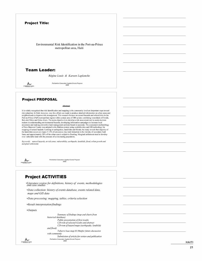
Developing a riskidentification tool for Port-au-Prince, Haiti
Even though most people agree on the fact that riskidentification and mapping at the community levelare important steps toward risk reduction, very fewefforts are made in this field in Haiti, except forcountry level hazard maps produced in 2001 byOxfam. The project focuses on natural hazards andrelated risks in the Port-au-Prince metropolitanregion within a study area of 588 sq km combiningwatersheds of Froide, Bois-de-Chêne and Grise rivers.
The main objective is to develop a risk assessmenttool to assist decision makers in understanding environmental hazards, developing informationcampaigns to increase local awareness and makingpreventive land management policies based on accurate data.
The methodology consists in literature review fordefinitions and methodologies, historical, statisticaland geospatial data gathering, analyses and interpre-tation, metropolitan area growth analysis. The NewHanover County risk assessment methodology ispartly used to prioritize natural hazards. The GIStool is used to digitize important features andproduce hazard and vulnerability maps.
Preliminary results show that the major naturalhazards for the P-a-P metropolitan area are hurri-canes, landslides, floods and earthquakes, based onfrequency, impact and magnitude. After analysis ofhistorical data over 100 years, 3 major hazards wereretained for the study based on frequency, damageeffect and magnitude: earthquake, landslides andfloods. Only the subsequent effects of hurricanewere analyzed. Earthquake is selected because therecurrence interval for a major event is exceeding280 years. Last major earthquake occurred in 1770.
Earthquakes
The mapping of geological faults over the study areashow concentrations of human settlements devel-oped on the alluvial cone of the Froide river. Theriver extends a secondary fault line in close vicinityof the major fault found active in the most recent 4.3 magnitude seismic event of 2005. Further studieswill determine the degree of vulnerability and proba-ble damaging effects.
Landslides
Recent geological reports show that most landslidesin P-a-P took place over the Delmas rock formation,a calcareous clay soil and the Morne l’Hopital forma-tion, a limestone. The events occurred during higherrainy periods. Mapping shows locations of slopes of
HAITI
HAITI
17
5-12% on calcareous clay and over 30% on lime-stone. The later landslides are mainly due to exces-sive sand mining which increased the vulnerability.
Flood
This analysis took into account proximity toseashore and river paths over slope classes to iden-tify flood-prone areas. The digital elevation model(DEM) reveals that close to 28% of the urban areais subject to this risk.
Extension of city limits and identified risk areas
The study shows that the urban area only repre-sented 2.15% of the combined watersheds in 1966and spread to 15.54% (144 sq km) in 2002 mainlyover flood-prone and high slope lands. Historicalmaps and notes of P-a-P of 1765 and 1785 showthat “city planners” took into account floodinghazards. Demographic explosion between 1982 and2003, over 2.5 million inhabitants at an annualgrowth rate of 1.6% for P-a-P, has put pressure onland and brought major informal settlements andunplanned residential neighborhoods over highrisk areas. Local risk and disaster awareness issecondary to shelter needs and economic activities.
Data and monitoring
This study shows the importance of data gathering,processing and updating on a regular basis. It alsoemphasizes the need for data sharing betweeninstitutions. The lack of accurate and regularassessment and recording of major events is one ofthe major constraints of this study. Suggestions aremade to institutions and the scientific communityat large, including universities, to improve datagathering mechanisms and financing.
Project Achievements
• Literature review for definitions, history ofevents, methodologies and case studies
• Data collection: history of events database,events related data, maps and GIS data
• Data processing: mapping, tables, criteriaselection
• Result interpretation/findings
• Outputs
Key Activities
Literature review
• Collected literature, data and information fromMDE, BME, DPC, UNDP, WebCT (virtual librarywith limited access), local newspaper, libraries,and communities themselves: we have identifiedthe institutions working directly or indirectly inrisk identification and disaster management.
• We have, either, consulted their work, madecopies of documents, or acquired electronicdocument files they have produced.
• We also have selected several publications andguidelines on WebCT related to our project. We chose the NOAA New Hanover County case study as a reference for methodologicalapproach. We developed an adaptedmethodology for our area of study based on available information.
Data collection
• We visited communities and/or acquired data collected by Oxfam GB through disasterawareness and preparedness informationsessions
• Maps and GIS information: most geographicaldata was gathered from UTSIG and based on a 1998 satellite image and 2002 aerial photo -graphs, useful comparative 1980 orthophotoswere donated by ONACA. UniQ Catesig labprovided the 1966 aerial photograph.
• Statistical data from IHSI 2004-Atlas based on the 2003 census, already available atUniQ/CATESIG and 2003 census reports on the West department and municipalities.
• Events history database was downloaded fromEM-Dat, Université Catholique de Louvain,Belgium and completed with more recentdata/information from literature, local news papers and local records of municipalities,if available. The time span covered at least 100 years.
Data processing
Historical data ranking We extracted a P-a-Pmetropolitan area subset from the original data-base produced a table taking into accountfrequency and magnitude and impact (damagingeffects) of major hazards; the ranking listed earth-quakes, hurricanes and landslides as top 3 events based on criteria mentioned above.
Equipment and software The project used 3laptops (Dell, Compaq and HP) and 1 Dell desktopcomputer (Urau lab) and 1 HP 1220C deskjetprinter. URAU provided access to internet andmeeting and work space for researchers andinterns.
Software used: MS Word for text editing; MS Excelfor financial tracking and accounting, historicaldisaster database, meteorological data; MSPowerPoint for presentations; Map Info, Geoconcept, Arc View for digital mapping).
Mapping Originally we selected 3 major water-sheds within Port-au-Prince as our study area (588 km2): rivière Grise, rivière Froide and Bois-de-Chêne. The P-a-P metropolitan covers an area1 of 144 sq kilometres (2002) and repre-sents only 15% of the combined water-shed area. It extends from the seashore up to 9.5 kms inland in some areas over a variety of slopes2 ranging from 0 to 60%. The urban seashore (littoral) extends from Mariani to Bon Repos on 35 kms, of which 27 is inside the combined watershed area.
Slope category: “0-2%” accounts for 13.2% of thecombined watershed area and for 28% of theurban layout. General consideration of environ -mental degradation3 of the watersheds was takeninto account (5.45% of “vegetation”4 cover).
Following this general information, critical informa-tion were combined and crossed: geological faults;most recent landslide locations; land cover,concentration of habitat (with indication of squatters/slums); critical facilities (public buildingsof importance, schools, churches…); hazardoussites (main fuel plants, electricity main stations…);major roads, ports and airports; and slopes, hydro-geology, geology, rivers and ravines, comparativephotographs and maps.
• Slopes, rivers and flood-prone areas – vs. human settlements (planned and slums)– higher elevation, slope vs. human settlements – vs. critical evacuation assets (national roads,
ports and airports)
• Geological faults, river paths, urban layout andhuman settlements
• Selected areas analyses in regards to concen -tration of human settlements and hazards(specifically looking at settlements on landslide-prone slopes, built in river beds, onseashore/swamp and/or estuary (eg. Citél’Eternel, Thor and Jalousie)
• Retrace slum formation in time 1966-2002 with land cover data, digitization of “highlypopulated neighbourhoods”, rivers and roads. The 1980 photographs are crucial forfollowing change in land use. However, theformat of the information gathered is not readilytreatable. However, a small selection was usedfor the Power point public presen tation of July29, 2006 at the Université Quisqueya.(Approximately an additional 3-4 weeks isneeded to extract relevant data, format and geo-reference)5
• Rivière Grise watershed case study—communeof Tabarre (more precise location of flood-proneareas); case study of Pernier and flooding w/sediments and debris vs neighbourhoodplanning.
Result interpretation/findings
• Earthquakes
• Floods and landslides
• Hurricanes
• Highly populated human settlements (slums)
• Lower density of occupation and high floodinghazard (Tabarre/Pernier)
Outputs
• Summary of findings (map and charts fromhistorical database)
• Public presentation of first results for commentsand reactions: July 29, 2006; 15 attendees6
• CD-rom of selected results, maps, reports andabstract (September for public dissemination)
• Abstract on slums and natural hazards;
• Tabarre base map (0.50m)for future discussionwith communities.
Constraints or Difficulties
Timeframe and data The methodology wasrevised due to time constraint and unavailability of data. Data for the societal analysis to locatespecific vulnerable groups within in our study areawill be available around August or Septemberaccording to IHSI. Therefore considerations forsocietal analysis are limited to slum areas based onempirical observation and image interpretation.
Data acquisition and financial processing UniQ’sadministration has slowed down the acquisitionprocess due to lengthy administrative proceduresseeking approval of dean of faculty and “recteur”of UniQ. It takes literally 3 to 4 weeks to approveand deliver a check.
HAITI
18
Accuracy of data The variety of the acquireddata did not help when format is not compatible.It is important to have notes on gathering proce-dures and methodology for users to make a betteruse of GIS information.
Opportunities and Discoveries
PRA-Ter is a newly formed research group provid-ing space for exchanges and working towardorganizing scientific workshops in September andDecember on land use/ risk and disaster manage-ment. PRA-Ter will host the first finding presenta-tion session of the project.
Oxfam is currently working on a Risk reductionproject for the metropolitan area to reinforce“local capacities to deal with natural and man -made hazards in specific neighborhoods. Ourresearch will provide valuable information to themfor the implementation of their “community riskreduction plans”.
Protection of the environment is one of the toppriorities of the newly installed Haitian govern-ment. UNDP is bringing technical expertise tosupport the ministries of Environment (MDE) andInterior (MICT) in their efforts towards risk anddisaster management. Some experts of UNDP arelooking into bringing universities into the process.
USAID is seeking of best ways to help Haitianuniversities to improve their work and benefitfrom exchanges with other US universities in therisk and disaster managed.
Assessment of Results
• Consolidated database
• Tables and charts
• Select criteria to define “risk zone”
After analysis of historical data7 over 100 years, 3 major hazards were retained for the study based on frequency, damage effect and magni-tude: hurricane, earthquake and flooding. Otherhazards, such as landslides, were also consideredas they are associated to these major events.Flooding can be considered as primary (major) orsecondary (associated) events.
Mapping the hazards is not easy when consideringdifferent criteria and characteristics. Each hazardis considered separately to locate risk zones andidentify high risk areas (when considering vulner-ability of human settlements).
Criteria for each event are based on literature,local expertise and history.8 So in an attempt todefine risk zone, one should consider the natureof hazard, history of/possible impact and land use (particularly human settlements).
The degree of vulnerability is function of the ability of communities to respond to hazardsbased of their specific situation. Lack of informa-tion and details postpone the production of avulnerability map, at this point.
A map for each hazard and a summarymap to show vulnerability
• Earthquake: construction (types of foundationand walls), no construction codes9,concentration of habitat, history of similarevents and damage;
• Hurricane/wind: roof types, construction wallmaterial, proximity to trees, access toevacuation routes and shelters;
• Flooding: foundation/base types, elevation,retaining wall resistance, roof types, number of stories and elevation; access to evacuationroutes and shelters; unplanned areas/ poor orno drainage;
• Landslide: construction (types of foundationand walls), housing unit’s weight, constructionmaterials, previous cracks on walls and floors;concentration of habitat, history of similarevents and damage;
Locate “risk zones” on a digitalvulnerability map
A general vulnerability map is difficult to show at this stage since it requires lengthier and morecomplex data gathering. However, specific casestudies on limited areas are used to demonstrateresults (Pernier, Tabarre or Vallée de Bourdon).
The work produced is based on the available dataand scale of analysis. Detailed study of a particu-lar area will be conducted on the second phase ofthe project due to time constraints. Data on loca-tion of vulnerable groups10 (age, poverty, handi-cap) is not yet available (august or September).
Conduct a multi-date analysis of theurban growth (P-a-P metropolitan area)
This analysis is not complete due to the incom-patible format of the aerial photograph of 1978(used as base for 1980 cadastre). Necessaryadjustments are being made to provide necessary
HAITI
19
information by the end of August. However visualcomparison on some areas is used in the powerpoint presentation.
The following activities will effectively take placein the second phase of the project:
• Evaluation of tool’s accuracy
• Dissemination and publication
Project Impact
• The project points out the lack of overallplanning and preventive measures; theministries of Interior (civil protectiondepartment) and Environment are addressingissues of risk reduction and management;however approaches are too broad to considerspecific characteristics of human settlements inurban areas.
• No land management policy; not learning fromprevious experience;
• No data collection processes; no localmonitoring of events; national system relies onNOAA for hurricane and storm alerts;
• Link between poverty and vulnerability; thesecond phase of the analyses will attempt tomake that link with available resources;
Project sustainability
• Involve other research faculty and experts(hydrology, ecology, geology) to continuespecific detailed analyses on selectedneighborhoods;
• Work with DPC, UTSIG, UNDP and involvedNGOs to develop a national risk identificationmethodology;
• Continue work with BME to further explore risksrelated to earthquakes and landslides byproviding some basic data making the link withhuman settlements;
Project ownership
• By means of presentation and dissemination(Web, e-mail, CDs) and by collaboration11
with other research groups working on thematter.
Project learning components
• Training of interns for use of GPS andArcView/Geo concept GIS program;
1 Communes of Port-au-Prince, Delmas, Tabarre, Cité Soleil, Pétion-Ville, parts of communes of Carrefour and Croix-des-Bouquets.
2 Slope category “12-30%” accounts for 35% of the watershed and slopes > 30% represents 37%. Low or no vegetation covertends to reduce water infiltration and increase velocity on high slopes, thus also increasing risk of flooding.
3 Based on UTSIG land cover map based on a 1998 satellite image; photo interpretation of the 2002 aerial photographs couldgive a better idea of rate of degradation.
4 Considering “forêts+systèmes agro-forestiers denses” of 1998 landcover analysis.
5 Internship work will extend beyond the due date of July 31 and consider as additional information since the study continues toupdate for presentations in September and December with PRA-Ter.
6 From universities (FDS, UniQ), international institutions (UNDP, USAID), public institutions (MSPP, UTE, PL-480...)
7 Analysis is based on available historical data compiled from multiple sources (Université de Louvain/Belgique, BME, Oxfam, G.Corvington, local newspapers, communities, articles); DPC does not keep records of disasters.
8 Les temps de retour sont particulièrement importants à considérer. Cette période 2004-2007 est critique pour le retour desgrands évènements catastrophiques : 1/100 ans pour le tremblement de terre (last : 19..), 1/10 pour les grands cyclones caté-gorie 4+ (last : Gordon 1998), 1 fois l’an pour les inondations qui augmentent avec la dégradation des bassins versants.
9 No para-seismic precautions;
10 IHSI is currently reformatting statistical data according to newly defined jurisdictions (communes of Tabarre and Cité Soleil).Public access to data will be possible in august or September.
In order to develop a feasibility study for the inte-gration of disaster management communicationsystems in Honduras, the project developed aninstrument for gathering and processing informa-tion as well as a bibliography for consultation.
Periodic reports in English were prepared, but thefeasibility study itself will be published in Spanish.
Project Achievements
• Information about Communication Systems ofthe Emergency organizations in Honduras
• Clear idea and vision about internationalsituation for interoperability efforts
• Clear idea about Mosquitia case (Gracias a DiosDepartment) and Technologies solutions
• Electronic library about interoperability activitiesin various countries
• Initial Technological solutions for all the countrywith various solutions considering small andlarge solutions
• Clear idea about the national context this topic
Key Activities
• Preliminary research about the CommunicationSystems for the Emergencies Agencies andprivate systems
• Travels at San Pedro Sula, Choluteca,Comayagua, Santa Rosa de Copan, Danli,Juticalpa and Ceiba
• Interviews with technical persons, andcompanies working in technical support with emergencies agencies
• Interviews with technical persons fromInternational companies: INMARSAT,MOTOROLA, JPS, Global UnitedCommunications, REDCOM
• Promotion and presentation activities withMechanical, Electricians and Chemical EngineersAssociation of Honduras (CIMEQH) and ProjectsOffice of the President
• Consultations with Information and Press officein American Embassy about of the activities inMosquitia zone on sponsor for the installationInternet access in this zone for the StateDepartment
• Internet research about this topic andinteroperability activities in others countries
HONDURAS
PROJECT REPORT
HONDURAS
27
• Research and information checking withagencies and persons with experience in radiocommunications systems.
• Monitoring with multiband radio portable (VX7RVertex) and Multiband Base (FT897D YaesuHF/VHF/UHF) of the operations of theemergency agencies
• Radio Engineering analysis in Mosquitia zone
• Promotion of study with various organizations
• Preliminary discussions with President ofMechanical, Electricians and Chemical EngineersAssociation of Honduras (CIMEQH) to publishstudy on their web site for open forum aboutthis topic
• Review of price and technological informationwith Raytheon JPS from North Carolina USA inreference to device interoperability and price andtechnological information from manufacturer of911 technologies— Motorola Astro 25 Systems
• Participation in Inmarsat workshop inTegucigalpa about products along with NationalDirector of Permanent Emergency Committee(COPECO) for Emergency Response in NaturalDisasters, Engineer Juan Carlos Elvir
• Visit with technical staff from MITEL, to explaintheir technologies
Constraints or Difficulties
• Very little information about this topic in mycountry, with reference to interoperability andintegrated communications systems.
• Access for information on frequencies and otherdata about the Communications Systems of theEmergency Organizations in Honduras.
• There is not one coordinating agency forEmergency Response; there is the PermanentEmergency Committee (COPECO) for EmergencyResponse in Natural Disasters, but also RedCross, Fire Department, Police, PrivateOrganizations, Secretary of Health, etc.
• There is no library of information or clearinitiatives realized about this topic.
Opportunities and Discoveries
• This is the first study about this topic in mycountry.
• This is a base to obtain the first approximationfor the integration of the CommunicationSystems of the Emergency organizations inHonduras, with: preliminary technologiessolutions; needs about national frequencies forrepeaters and simplex operations; reorganizationfor Emergencies response; and total technologiessolutions for Emergency organizations inHonduras and the Public Sector.
• The opportunity to make the first Electroniclibrary about this topic in my country athttp://www.cimeqh.org
• During the visit a Santa Rosa of Copan City in January 2006, we made an initial proposal of the Central American Medical Outsource(CAMO) and Rotary Club organizations to begininitiatives for integration of the communicationssystems: Permanent Emergency Committee(COPECO), Red Cross, Fire Department, police,Radio Volunteers, and local organizations in asmall dispatch center similar or something like911 in USA.
• It is very important to travel and interview inthis process, interchange experience and receivecomments about this topic and other topicsconnected with this study BioComm SystemsHonduras, seeking funds to continue activities in Honduras on this process with Emergencyand Disasters Commission of Mechanical,Electricians and Chemical Engineers Associationof Honduras (CIMEQH).
Assessment of Results
In this study my team realized many activities; atthis moment we are integrating the activities andevolution as a base for development and searchingfor the data and especially information inHonduras and world wide. We don’t have anEnglish version of the full study, but it is availablein Spanish there will be an executive summary inEnglish.
HONDURAS
28
Project Impact
This first study about this topic in my country isvery important for technological orientations tointeroperability and integrations of communica-tions systems for the Emergency Organizations in Honduras, with:
• preliminary technology solutions
• needs about national frequencies for repeaters and simplex operations
• reorganization for emergency response
• total technology solutions for emergencyorganizations in Honduras and the Public Sector
This can be a base for the inclusion ofTelecommunications Systems for Honduras for multiple applications to various agencies. We know that more activities are needed now,including planning for additional funds, offeringassistance and promotional activities about thistopic in academic centers, nationally and interna-tionally. This project is a great experience for myteam and today we know how important theseactivities are. More people in Honduras willsurvive emergencies if we can realize some or all of initiatives from this project. We also believe that the situation in other Latin Americancountries is very similar, so that this study isimportant for more implementation of similarnational or regional projects on this topic.
HONDURAS
29
JAMAICA
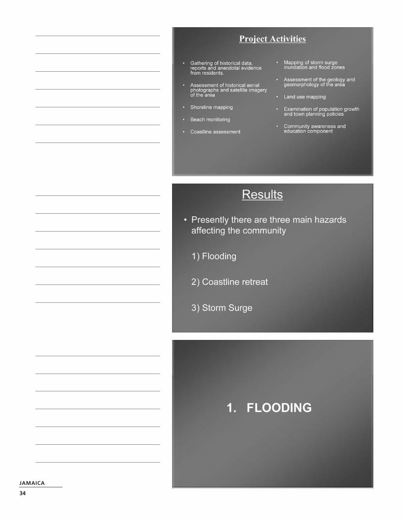
Coastal communities—high risk orpoor planning; Annotto Bay,Jamaica: A case study
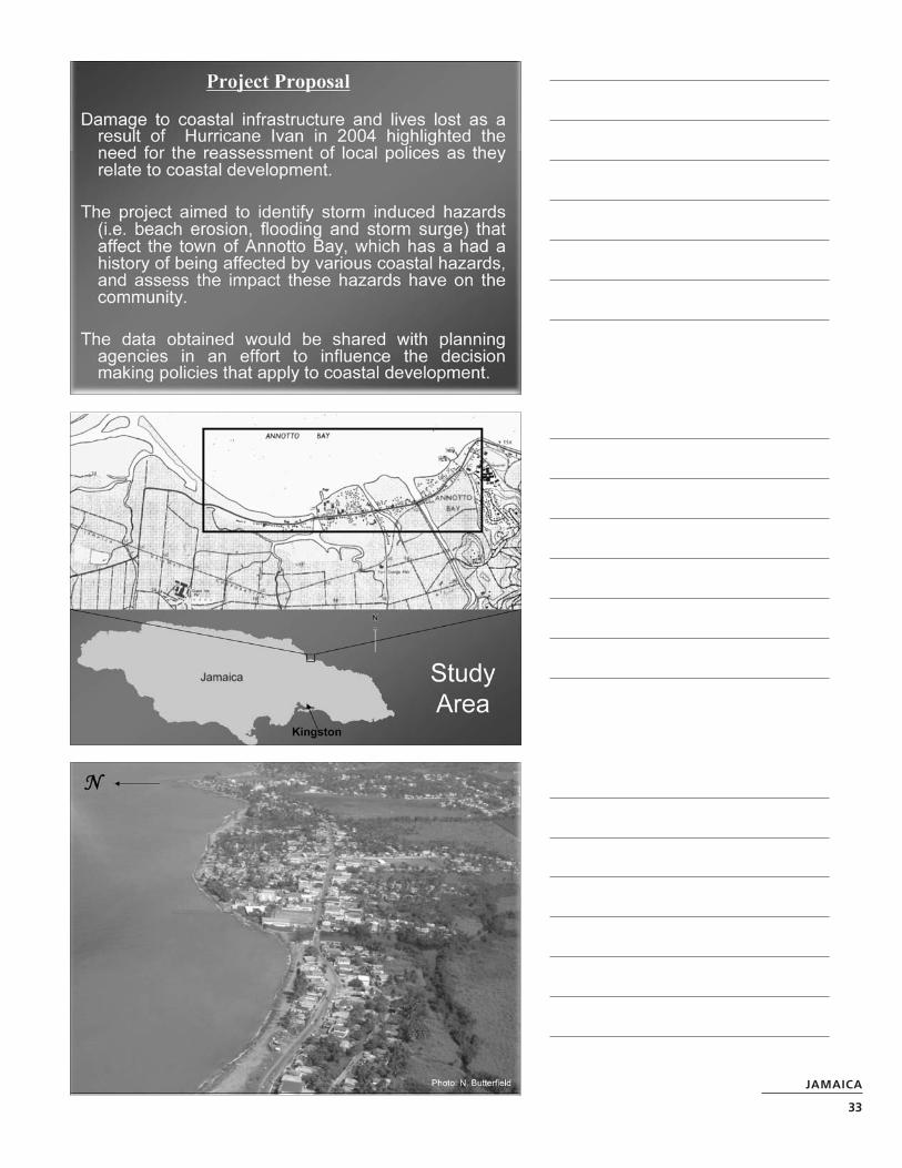
Storm induced hazards are a constant threat tocoastal communities in small island states likeJamaica whose population centers are situatedalong the coast. Damage to infrastructure such asbuildings, roads and bridges as well as the liveslost through these events have highlighted theneed for the assessment of the local policies asthey relate to coastal development.
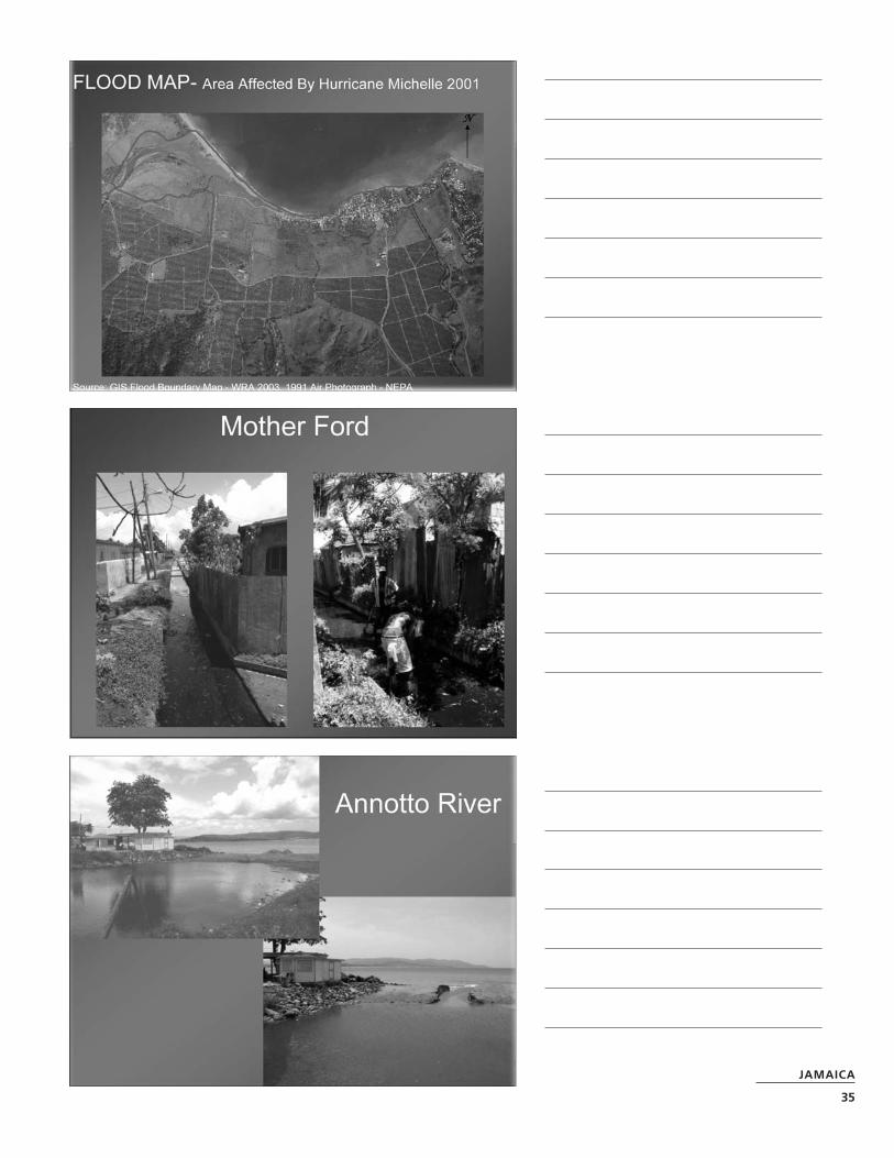
The aim of this study was to identify the hazardsthat affect coastal towns and examine whether ornot the risks are heightened due to poor townplanning policies. This study documented hazardssuch as beach erosion, storm surge and storminduced flooding that have affected the coastaltown of Annotto Bay. The production of a hazardmap of the area and report were the final steps inthis project. This information was provided to thecommunity as well as relevant agencies in thehope that the information gathered can be utilizedfor mitigation measures as well as in future coastalplanning guides.
Project Achievements
• Identified hazards that affect the community of Annotto Bay
• Created hazard maps for the area
• Shared project findings with community andrelevant organizations through meetings.
• Produced brochures for the community toexplain hazards affecting the area
• Raised community awareness of hurricaneinduced hazards that affect the area.
• Created baseline data for use in developingmitigation strategies.
Key Activities
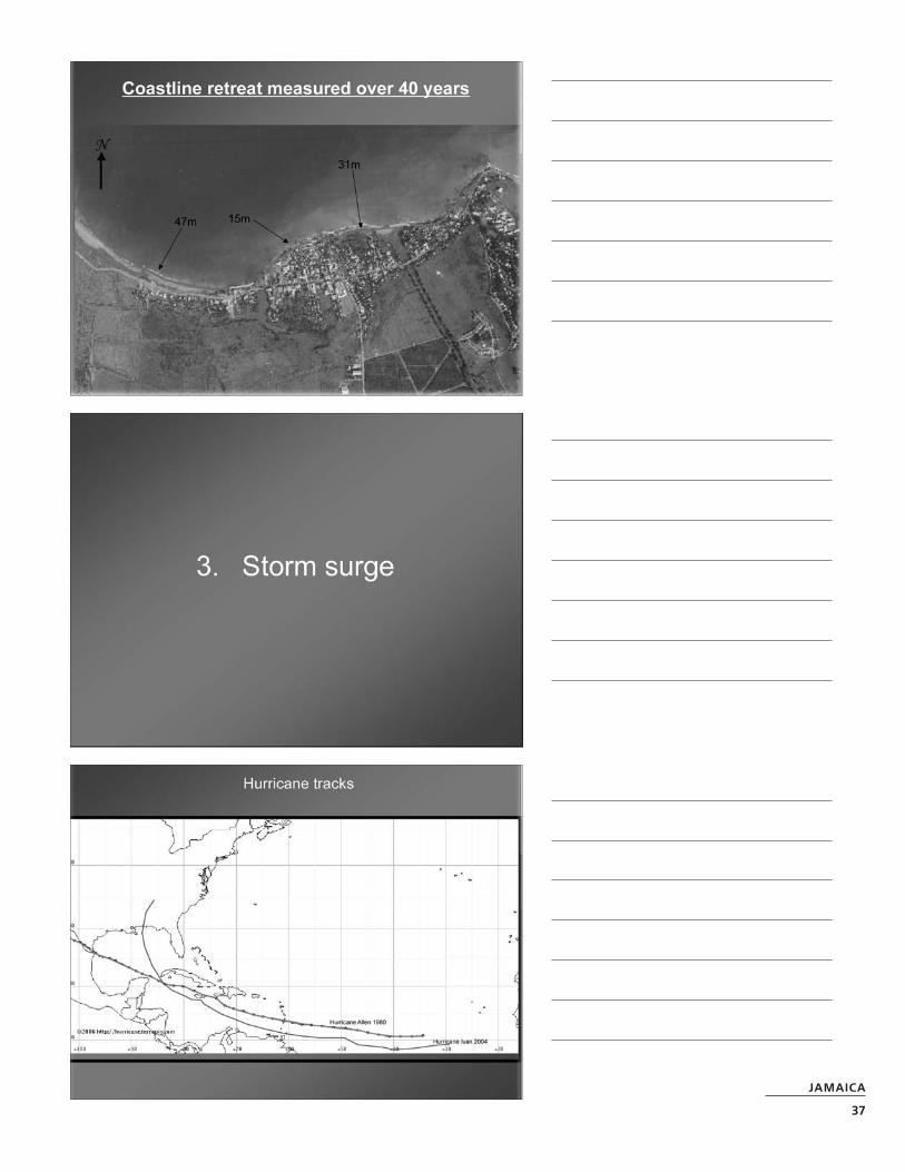
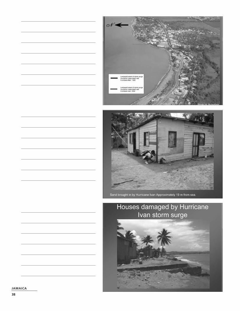
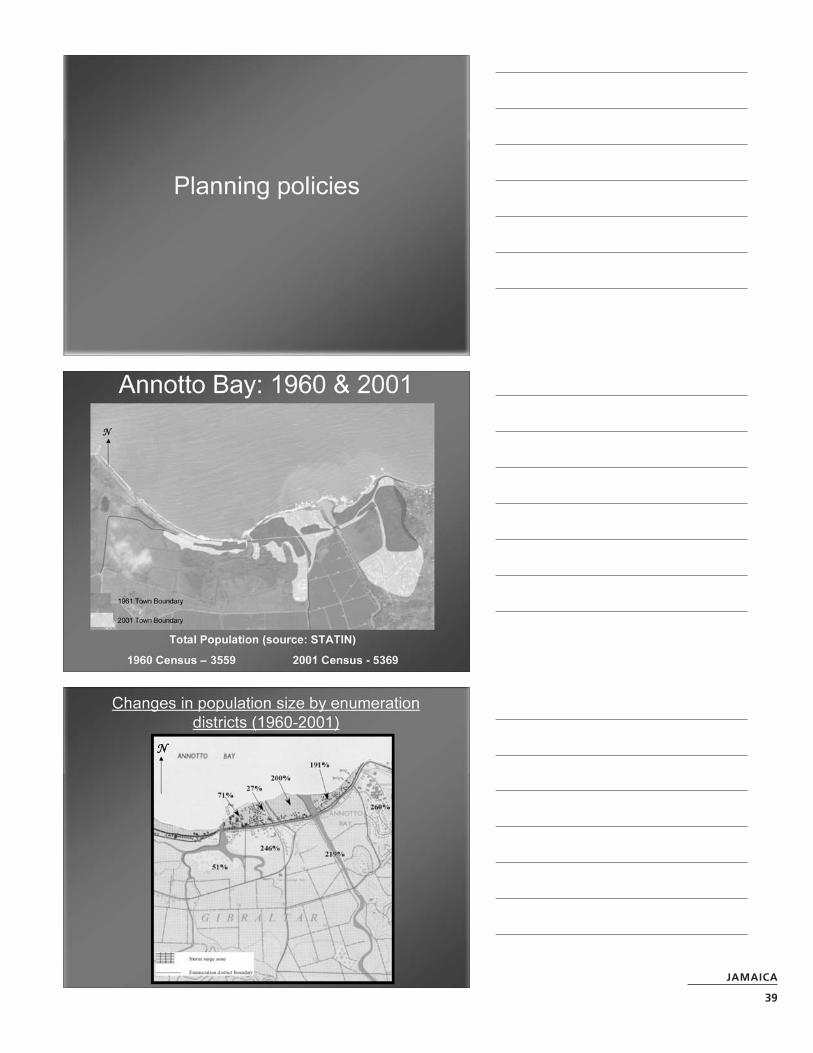
Identification of hazards that affect the community This was done between September2005 and July 2006 and involved assessment ofcoastline positions over 40 years using air photo-graphs, satellite imagery and GPS mapping of thepresent coastline and monitoring of beach widthon a monthly basis. The Impact of flooding on thecommunity was determined from communitysurveys and reports which document the floodevent of 2001. Storm surge inundation, forHurricane Ivan in 2004, was mapped using anecdotal evidence from community members and compared to that of Hurricane Allen, in 1980,mapped by C. Wilmot-Simpson.
Created hazard maps for the area Posters(36”x48”) were designed with a hazard map andaccompanying text to explain how to use a hazardmap and types of hazards that affect the area.These were presented to several organizations inthe community i.e. the library, schools, the Healthand Environment Committee, the regional coordi-nator for the Office of Disaster Preparedness andEmergency Management etc.
Shared project findings with community andrelevant organizations through meetingsPresentations were made to the communitythrough organized meetings to gather informationon the impacts of hazards in the community anddiscuss the initial findings in the early stages ofthe project. A final presentation was made todisseminate the findings of the project and getfeed back from the community.
Produced brochures for the community toexplain hazards affecting the area Brochureswith information specific to the community ofAnnotto Bay were designed to explain the types ofhazards in the area and measures the communitycan take to be better prepared in the future. Thebrochure also provides individuals with a smallerversion of the hazard map and shows evacuationroutes to the nearest emergency shelter.
Raised community awareness of hurricaneinduced hazards that affect the community areaContinued interaction with the community has ledto increased awareness and improved understand-ing of the hazards that affect the community.
Created baseline data for use in developing mitigation strategies Through this project thecommunity has been equipped with additionalinformation about the various mitigation solutionsavailable to them. They now have quantitativedata which will assist them in their efforts to getofficials to provide assistance to the community.
Constraints or Difficulties
Early in the project bad weather conditionshampered field work. The rain delayed door todoor surveys needed to identify the effects of thevarious hazards on residents; however this wascompleted by the end of the project. As reportedin the January mid way report the most surprisingdiscovery was the lack of information availablefrom the various government agencies, regardingdamage from previous hurricanes or storms and inparticular information on town planning and landuse in the area.
Some computer difficulties were encounteredduring the preparation of the hazard maps usingGIS however the Marine Geology Unit allowed usto use their computers and soft ware to completethe task.
Opportunities and Discoveries
As suggested by our mentor at the end of January,we presented the study findings to a wider audi-ence through government’s information servicetelevision series program “Question and Answer”.
Several other opportunities presented themselvesin the second half of the project; we were able touse the findings of this study as part of a lectureseries given to Florida International Universityundergraduate students visiting the Geographyand Geology Department and we presented apaper entitled Impacts of storm induced hazardson coastal communities. Annotto Bay: a case studyat an international conference held in Jamaica onJuly 24th 2006– Global Change and CaribbeanVulnerability: Environment, Economy and Societyat Risk? hosted by the Department of Geographyand Geology UWI Mona and the Climate ChangeResearch group and Developing Areas group of theRoyal Geographical Society/ Institute of BritishGeographers. We also successfully submitted apaper on our findings to Tudor Rose for publica-tion in a book entitled “REAL RISK”.
Assessment of Results
Collection of field data related to the physicalimpacts that storms have on the community wasachieved and although we fell behind the sched-uled time we managed to be completed this aspectby April 2006. Identification of published datarelating to planning policies proved to be problem-atic and attempts to acquire his informationcontinued through June 2006. The one monthextension awarded to awardees allowed us tocatch up, particularly with the dissemination ofinformation to identified stakeholders.
Project results were presented to the communitythrough power point presentations. Hazard mapsof the area were presented to key stake holders(schools in the community, library, Health &Environment committee and NEPA regional office)and brochures distributed to community memberswith a simplified hazard map with evacuationroutes and safety tips. A technical report is to bepresented to the parish council, NEPA head officeand the ODPEM.
JAMAICA
31
Project Impact
The data acquired through this project should beshared with other government agencies and NGO’sincluding the Marine Geology Unit (MGU) at theUniversity of the West Indies, so that the impact ofhurricanes on coastal communities and measuresto reduce vulnerability can be better understood.The MGU will continue to monitor the impacts of
storms and coastline changes along this coast aspart of their ongoing project, and can use thestudy as a model for the other communities withsimilar coastal characteristics.
Appended to this Working Paper are slidespresented at a Regional ProVention Web-Conference in October 2006
JAMAICA
32
JAMAICA
33
JAMAICA
34
JAMAICA
35
JAMAICA
36
JAMAICA
37
JAMAICA
38
JAMAICA
39
JAMAICA
40
JAMAICA
41
JAMAICA
42
Cultural vulnerability, risk perception andcommunication:Towards a community participatoryapproach for disaster prevention inthe Municipality of Tlatlauquitepec,Sierra Norte de Puebla, Mexico
Roberto Carlos Borja-BaezaRicardo Javier Garnica-PeñaOmar Esteban Chávez
PROJECT ADVISOR
Dr. Irasema Alcántara-Ayala
KEYWORDS
Cultural vulnerability, indigenous communities,communication, risk perception, landslides
Project Summary
This research project involved the analysis ofcultural vulnerability, risk perception and commu-nication of indigenous communities in the SierraNorte de Puebla, specifically in the municipality ofTlatlauquitepec. Based on field observations andsatellite images, a landslide inventory of the areawas elaborated. Vulnerability of communities wasanalyzed by considering the information producedby the population census and contrasted with thereality. Aiming at the integration of local knowledgeinto the disaster prevention process, several work-shops to construct landslides risk maps wereundertaken in several communities. Results will be combined with detailed “scientific” (geomorpho-logic) terrain assessments to prepare a final version to be given to the corresponding authori-ties. Finally, it was detected that levels of analpha-betism are so high that the tentative productionand distribution of an information booklet concern-ing landslides was withdrawn, since a very lowpercentage of population can read Náhuatl. As aconsequence, four information audio warningswere developed; they concerned floods and land-slide hazards and were recorded in both, Náhuatland Totonaca, the most widespread indigenouslanguage spoke in the region.
Project Achievements
• Fieldwork (1st stage)
• Analysis of satellite images
• Community workshops
• Landslide inventory
• Vulnerability analysis
• Development of a landslide information bookletin Náhuatl: assessment of applicability
• Development of radio warnings in Náhuatl andTotonaca
• Landslide risk mapping by communities
Key Activities
• Fieldwork
• Observation and mapping of landsliding
Analysis of satellite images provided by theInstitute of geography have been used as follows:
• Building mosaic of the municipality
• Identifying landsliding areas
• Building up the landslide inventory
• Vulnerability analysis
MEXICO
WEB CT ID
2155MEX
PROJECT REPORT
MEXICO
43
Community workshop Different workshops wereorganized at different stages as follows:
• Informing the population about the project
• Presenting the significance of landsliding in the area
• Introducing the people to the material beingdeveloped (Náhuatl booklet)
• Analyzing landsliding field evidence
• Booklets review/feedback from the communities
• Developing of audio warnings for floods andlandslides in Náhuatl and Totonaco
• Mapping of landslide hazard areas bycommunities
Analysis of the landscape elements of theTlautlauquitepec municipality Informationreview of the landscape elements and mapping of principal features:
• Geological map
• Geomorphologic map
• Map of localities
Constraints or Difficulties
During the first part of this investigation, the mainconstraint found was associated to the supportsupposed to be given by the municipality’s author-ity. A new Head of the Civil Protection Unit ofTlatlauquitepec was appointed, but he had no ideaabout disaster prevention. Before working for themunicipality, he was making a living as a baker.Therefore all requested information from theMunicipality was not provided to us. Field workhence has been the main source of data gathering.Particularly importance to notice is the fact thatwhen governments (even at local level) change,they do not pass the generated information ontothe following authorities and work has to startfrom cero all the time.
Opportunities and Discoveries
We are not sure it can be considered exactly assurprising discovery, but it has been rather nice tosee that the greatest percentage of populationinterested in our activities are women. This isimportant because we believe women may play amajor role in disaster prevention.
In the last stage of the project, particularly it wassurprising to find out that our initial idea ofproducing and distributing a booklet on landslide
information in Náhuatl was useless due to the lackof population with reading skills. In any case, theelaboration of audio warnings was enriched and 4forewarnings were finally produced (floods andlandslides; in Náhuatl and Totonaco).
Assessment of Results
We consider that our research was an overwhelm-ing experience and we were able to produce inter-esting results. Additionally, although we wereworking in communities with low levels of accessi-bility, our work will continue within the frame ofthe projects undertaken by our mentor.
Project Impact
Developing countries are indeed target of disastersgiven the high levels of vulnerability they have.Particularly rural areas are not strategic popula-tions for the government and therefore no supportfor development is provided. Level of education israther low and communities struggle for survivalon daily basis. Poverty is worsened when disasterstake place because recovery involves very longperiods of time. Most of the time such helpprovided by overseas or national bodies is notgiven on the spot to the needed people (after thedisaster), or in many cases is used to supportpolitical campaigns or a small sector of the popula-tion. Moreover, rural areas have no adequateaccessibility neither to development not to behelped in times of disaster. Communication israther scarce and attention is never given toprevent disasters.
This project tries to address the links betweendevelopment and disaster risk reduction in Mexicoby looking at the problems indigenous communi-ties face in terms of communication within a disas-ter prevention frame. It is impossible to talk aboutdevelopment when populations with high vulnera-bility levels are located in the most physicallysusceptible areas to natural hazards.
Project sustainability
The idea we have is to continue working with thecommunities as part of other research projects thegroup that we belong to has, and specially, as apostgraduate students we are organizing a coupleof workshops to be given to local authorities sothat they learn using the information we haveproduced on a Geographical Information System.
MEXICO
44
Project ownership
Such community ownership will be given by thecontinuous research we will be developing, aswell as by the feedback among local authorities,communities and our group.
Project learning components
Communities are the most important actors of anydisaster prevention framework. Indigenouscommunities have to be taken into account tounderstand and mitigate risk.
Education is the base for any society; a commu-nity with no access to education can not join thechain of development. Lack of development onareas highly susceptible to natural hazards leadsto an infinite underdevelopment. Access to infor-mation and education is the first step to riskreduction.
MEXICO
45
For additional regional information, please contact:
Asian Disaster Preparedness Center(ADPC)Bangkok, ThailandWEBSITE: http://www.adpc.net/
Disaster Mitigation for Sustainable Livelihoods Programme (DiMP)University of Cape Town, South Africa WEBSITE: http://www.egs.uct.ac.za/dimp/
University of Wisconsin–Disaster Management Center (UWDMC)Madison, WI, USAWEBSITE: http://dmc.engr.wisc.edu/
The findings, interpretations and conclusionsexpressed in this report are those of the authorsand editors and do not necessarily represent theviews of the ProVention Consortium/IFRC.