A comprehensive archaeological map of the world’slargest preindustrial settlement complexat Angkor, CambodiaDamian Evans*†, Christophe Pottier‡, Roland Fletcher§, Scott Hensley¶, Ian Tapley�, Anthony Milne**,and Michael Barbetti††
*Archaeological Computing Laboratory and §Department of Archaeology, University of Sydney, Sydney NSW 2006, Australia; ‡Ecole Francaised’Extreme-Orient, Siem Reap, Cambodia; ¶National Aeronautics and Space Administration Jet Propulsion Laboratory, 4800 Oak Grove Drive,Pasadena, CA 91109; �Horizon Geoscience Consulting, Perth WA 6020, Australia; **School of Biological, Earth and Environmental Sciences,University of New South Wales, Sydney NSW 2052, Australia; and ††School of Physical Sciences, University of Queensland,Brisbane QLD 4072, Australia
Edited by Michael D. Coe, Yale University, New Haven, CT, and approved June 29, 2007 (received for review March 17, 2007)
The great medieval settlement of Angkor in Cambodia [9th–16thcenturies Common Era (CE)] has for many years been understoodas a ‘‘hydraulic city,’’ an urban complex defined, sustained, andultimately overwhelmed by a complex water management net-work. Since the 1980s that view has been disputed, but the debatehas remained unresolved because of insufficient data on thelandscape beyond the great temples: the broader context of themonumental remains was only partially understood and had notbeen adequately mapped. Since the 1990s, French, Australian, andCambodian teams have sought to address this empirical deficitthrough archaeological mapping projects by using traditionalmethods such as ground survey in conjunction with advancedradar remote-sensing applications in partnership with the NationalAeronautics and Space Administration (NASA)/Jet Propulsion Lab-oratory (JPL). Here we present a major outcome of that research:a comprehensive archaeological map of greater Angkor, coveringnearly 3,000 km2, prepared by the Greater Angkor Project (GAP).The map reveals a vast, low-density settlement landscape inte-grated by an elaborate water management network covering>1,000 km2, the most extensive urban complex of the preindustrialworld. It is now clear that anthropogenic changes to the landscapewere both extensive and substantial enough to have created gravechallenges to the long-term viability of the settlement.
archaeology � geographic information systems � remote sensing �Southeast Asia � urbanism
The first century of scholarship on Angkor, in Cambodia, wasdominated by the need to conserve and restore the monuments,
to locate Khmer civilization within broader cultural history, and toestablish a basic chronological framework for Angkor and itsSoutheast Asian empire [9th–16th centuries Common Era (CE)]. Inthe early 1950s, Bernard-Philippe Groslier of the Ecole Francaised’Extreme-Orient (EFEO) became the first scholar to pay seriousattention to the traces of a hydraulic network that had been partiallymapped in the first half of the 20th century. Groslier surmised thatit was both built and used for irrigation, specifically, to amelioratevariations in agricultural output caused by an unpredictable annualmonsoon and to support a huge population of greater than a millionpeople (1) in a constellation of suburbs. He also argued that theextent and breakdown of the network was implicated in the demiseof Angkor (1, 2).
As one of the very few scholars in the 20th century with both anawareness of and an interest in the settlement pattern surroundingthe monuments, Groslier also understood that a comprehensiveand integrated program of archaeological research, includingground survey, remote sensing, and archaeological mapping, wasneeded to broaden the perspective beyond the great monumentsand to provide a firm basis for assessing his theory (1–5). Impor-tantly, he commissioned topographic maps of Angkor at 1:10,000
scale (5) that provided a much-needed foundation for archaeolog-ical mapping.
However, the burden of the conservation d’Angkor in the 1960sand the dire circumstances of Cambodia from the 1970s to the early1990s made it impossible to fully realize his agenda: his archaeo-logical mapping never went beyond the preliminary and rawtopographic base maps, which remained unpublished until 1993 (6).Additionally, these maps were never completed for the area northof Angkor Thom, thus reinforcing a longstanding focus on thecentral and southern areas at the expense of the northern region.As a result, Groslier continued to use simple schematic maps todevelop his theory (1) and Angkor remained, until the early 1990sand still to some extent even today, only partially understood as asettlement, as an inhabited space in which much of the economic,residential, agricultural, and probably even ritual activity took placebeyond the walled enclosures and great stone temples of centralAngkor.
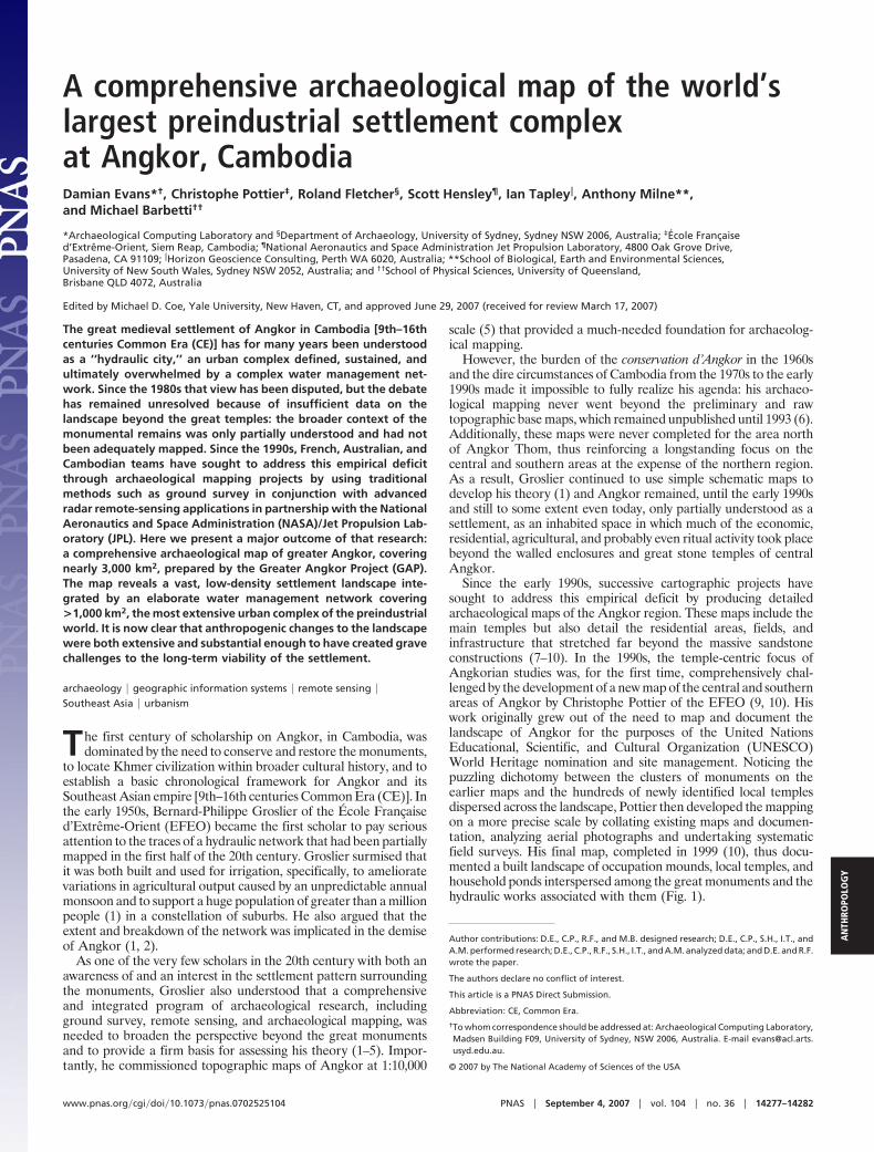
Since the early 1990s, successive cartographic projects havesought to address this empirical deficit by producing detailedarchaeological maps of the Angkor region. These maps include themain temples but also detail the residential areas, fields, andinfrastructure that stretched far beyond the massive sandstoneconstructions (7–10). In the 1990s, the temple-centric focus ofAngkorian studies was, for the first time, comprehensively chal-lenged by the development of a new map of the central and southernareas of Angkor by Christophe Pottier of the EFEO (9, 10). Hiswork originally grew out of the need to map and document thelandscape of Angkor for the purposes of the United NationsEducational, Scientific, and Cultural Organization (UNESCO)World Heritage nomination and site management. Noticing thepuzzling dichotomy between the clusters of monuments on theearlier maps and the hundreds of newly identified local templesdispersed across the landscape, Pottier then developed the mappingon a more precise scale by collating existing maps and documen-tation, analyzing aerial photographs and undertaking systematicfield surveys. His final map, completed in 1999 (10), thus docu-mented a built landscape of occupation mounds, local temples, andhousehold ponds interspersed among the great monuments and thehydraulic works associated with them (Fig. 1).
Author contributions: D.E., C.P., R.F., and M.B. designed research; D.E., C.P., S.H., I.T., andA.M. performed research; D.E., C.P., R.F., S.H., I.T., and A.M. analyzed data; and D.E. and R.F.wrote the paper.
The authors declare no conflict of interest.
This article is a PNAS Direct Submission.
Abbreviation: CE, Common Era.
†To whom correspondence should be addressed at: Archaeological Computing Laboratory,Madsen Building F09, University of Sydney, NSW 2006, Australia. E-mail [email protected].
Pottier also showed decisively that the great reservoirs, or barays,had inlets and outlets and were connected to a network of channelsand embankments, contrary to the assertions of critics of Groslier’shydraulic thesis from the 1980s onwards (11–14). Moreover, thelongstanding assumption (2, 11) that the extensive agricultural fieldsystems visible on the surface today might date from Angkoriantimes was supported by his new map, which displayed the integralconnection between the local temples and their agricultural space(15). Various other elements of the classical Angkorian landscape,in particular, the small ponds described in an account of Angkor inthe 13th century (16), have also persisted on the surface, wereclearly identifiable from the air and have often been renovated andreused by the contemporary Khmer population. Archaeologicalevidence of Angkorian occupation (in particular, brick and ceramicdebris) was consistently found at the sites that had been identifiedfrom the air and was documented and collected wherever appro-priate (10). Field verification continues across the greater Angkorregion in a process that has consistently matched aerial observationswith surface evidence. Recent excavations at the Siem Reap airport(17) and elsewhere have provided further stratigraphic evidence ofcontinuity between subtle topographic features visible on thesurface today and the urban landscape of medieval Angkor.
Pottier’s new study used the maps commissioned by Groslier asa cartographic base (because they were the only available ones atthat time), and began the process of creating a comprehensivearchaeological map of Angkor by recording several thousand ofthese features and part of agricultural field system within an area of�1,000 km2. The coverage of that survey was limited to thesouthern and central parts of Angkor by the available cartographicbase and by the persistent security risks in Siem Reap Province until1998. However, it was clear from remote sensing that the contiguoussettlement space of Angkor extended well beyond what had beenmapped; further survey was therefore required.
Since the completion of Pottier’s initial mapping in 1999, theGreater Angkor Project (GAP), an international research program(Australian, Cambodian, and French) focusing on the spatialstructure, the water management network, and the reasons for the
decline of Angkor, has continued to extend the spatial coverage ofdetailed archaeological mapping by using a diverse range of datasources, field techniques, and, notably, airborne imaging radar(AIRSAR) data acquired for GAP in 2000 by National Aeronauticsand Space Administration (NASA)/Jet Propulsion Laboratory(JPL).
MappingOne of the first tasks was the digitization of Pottier’s 1999 hand-drawn map and the conversion of its data into a geographicinformation system. Subsequent mapping work has concentratedon the use of airborne radar imaging (AIRSAR/TOPSAR) forarchaeological survey, in particular using data acquired over An-gkor in September 2000 by NASA/JPL on behalf of GAP (18),expanding on previous radar data acquisitions in 1994 on behalf ofthe World Monuments Fund (SIR-C/X-SAR) and in 1996 on behalfof Elizabeth Moore of the University of London, London, U.K.(AIRSAR). The first stage of GAP’s analysis, begun in 2001 andcompleted in 2002, was undertaken with a view to very quicklyproducing a ‘‘broad-brush’’ picture of the settlement pattern to thenorth of Pottier’s study area. The specific aims were to gain anunderstanding of the interaction of microwave sensors with thearchaeological landscape, to develop and refine methods of sys-tematically applying imaging radar to an archaeological investiga-tion, and to assess the feasibility and likely outcome of a moredetailed survey incorporating heterogeneous data sources.
The AIRSAR instrument is an active sensor with the ability topenetrate clouds. On its 2000 deployment over Angkor, multiplechannels of data (C band at 3 cm, L band at 25 cm, and P band at64 cm, with polarisation measured at transmit and receive) wereaquired over �8,000 km2 through 98% cloud cover. The ability ofthe AIRSAR instrument to produce high-quality, high-resolutiondata sets describing surface roughness and electrical properties iswell documented [Jet Propulsion Laboratory (2006) AIRSAR Air-borne Synthetic Aperture Radar Documentation. Available at http://airsar.jpl.nasa.gov/documents/index.html] and does not warrant de-tailed treatment here. It is, however, worth noting that the abilityof the instrument to distinguish very subtle differences in surfacevegetation and surface moisture was of particular use in uncoveringthe archaeological landscape at Angkor. The distinctive spatialpatterning of features manifests itself primarily in slight variationsin topographic relief, which in turn produces variations in thespecies of surface vegetation and soil humidity. These stronglyinfluence the amplitude or ‘‘brightness’’ of the radar signal returnedto the sensor.
A very important example of this phenomenon is the localtemple, which usually consists of a �20-m square central mound of�0.5 m to 2 m in height, surrounded by a shallow moat of less than�1 m in depth and usually traversed by an earthen causeway on itseastern side, lending the moat-and-mound complex a distinctivespatial structure. This complex in turn typically has a small rect-angular reservoir immediately to the east, whose orientation isgenerally east-to-west and whose ratio of length to width is �2:1.Some of the local temples have architectural remains such as bricksscattered on the surface and are well known as temple sites, whereasmany others have been completely subsumed by modern residentialor agricultural developments and are essentially undetectable onthe ground. Most of these temples, however, can be detected in theradar imagery. For example, in many cases the slightly lowerelevations of the rice fields in the former moat and reservoir and theslightly higher elevations of the fields built on top of the remnantmound and reservoir banks result in different stages of rice maturityand in differential levels of soil moisture content, which stronglyaffect the returned radar signal. Moreover, the bunds of the ricefields act as very bright corner reflectors to the radar signal. The factthat remnant moats and reservoirs are usually subdivided into thesefields serves to delineate the typical spatial configuration of atemple site very clearly within the radar imagery. For the same
Fig. 1. Oblique aerial views of remnant Angkorian urban features. (UpperLeft) Occupation mounds and ponds. (Upper Right) Canals and embankments.(Lower Left) Multifunction roadway/canals. (Lower Right) Classic ‘‘villagetemple’’ configuration.
14278 � www.pnas.org�cgi�doi�10.1073�pnas.0702525104 Evans et al.
reasons, the identification and mapping of Angkorian field systems,linear features such as roads and canals, and the ponds thatsurround the local temples can be performed very quickly andeffectively using these data (19).
From 2000 to 2002, some 1,500 km2 of the landscape beyondPottier’s 1999 map were studied from the AIRSAR images (7), withall features documented and mapped within a geographic infor-mation system environment. The results of this initial survey wereextremely promising. A highly complex linear network to the northof Angkor was revealed, adding great detail to the area describedby Groslier, as well as significant residential and agriculturaldevelopment throughout a large part of the study area. The GAPexcavations have indicated a degree of human occupation alongsome of the embankments and channels of the network (8),connecting the infrastructure to the residential pattern of Angkor.The mapping also showed that Angkor had a complex, tripartite,water management network for systematically stabilizing, storing,and dispersing water.
The preliminary archaeological map of the Angkor area resultingfrom the AIRSAR study has, until now, represented the mostcomplete picture of the settlement. Importantly, although the mapand any conclusions drawn from it were highly provisional, itbecame increasingly clear from this work that the site representedpossibly the largest complex of low-density urban development inthe preindustrial world.
Ultimately, however, the ability of this map to provide a final,decisive picture of the settlement landscape of Angkor was limitedby the horizontal spatial resolution of the radar data. At 5 m it didnot allow the consistent recognition of occupation mounds andmade the identification of local temples and small ponds problem-atic. Also, the methodology was dedicated as much toward assessingthe radar’s capabilities as it was toward the particular historicalproblem of urban development at Angkor.
The next stage of mapping, from 2003 to 2007, was designed tomove the cartographic project toward a definitive conclusion. Anotable change from previous surveys of Angkor was the specifi-cation of a nonarbitrary survey boundary. In light of the GAP focuson the extent of human manipulation of water resources, it wasdecided to use the watershed catchment boundaries of Angkor’srivers‡‡ to define a study area. The study area covers 2,848 km2,divided into 1-km grid squares. Each was analyzed individually indetail, with consideration given to all of the available evidence,including the diverse site inventories, every archaeological mapproduced over the last century, topographic data sets, and remotelysensed data from a range of sources, including Landsat, ASTER,SPOT, AIRSAR, Ikonos, Quickbird, and conventional aerial pho-tography, in particular the 1:25,000-scale Finnmap 1992 coveragealready used by Pottier (10).
The understanding of radar’s interaction with the archaeologicallandscape developed in the previous study was brought to bearheavily on this work, which was considerably enhanced by thedelivery in 2003 by NASA/JPL of a digital elevation model derivedfrom the September 2000 AIRSAR deployment. This TOPSARdata set specifies a height value for every 5 m2 of the landscape withsubmeter accuracy and allows for extremely precise analyses of thesubtle topographic variations that characterize remnant Angkorianfeatures.
In contrast to the radar-derived preliminary archaeological mapof 2002, the 2007 map is conservative in the features mapped anddisplayed. A feature had to be visible in at least two different datasources or to be verified from ground level or low-altitude aerial-survey to satisfy the criteria for inclusion. It is anticipated, therefore,that a number of features will be added to the map as verification
continues, just as some features will inevitably prove to be post-Angkorian and will need to be removed. This process continueseven for Pottier’s map, which has been well verified and covers areasthat have been intensively studied for over a century. It is extremelyunlikely, however, that the addition or subtraction of a relativelysmall number of minor features will qualitatively alter the currentrepresentation of settlement space and the overall layout of thewater management network. In this sense the map presented herecan be considered definitive.
ResultsThe final phase of the mapping work, completed in 2007 andpresented here (Fig. 2), reveals Angkor as an extensive settlementlandscape inextricably linked to the water resources that it increas-ingly exploited over the first half of its existence. It was not simplya succession of spatially distinct ceremonial centers or a carefullyplanned sacred space but, as Coe suggested in 1957 (20), a low-density urban complex like the Classic Maya cities of the Yucatanpeninsula such as Tikal (21). As with modern low-density cities andthe Classic Maya cities, Angkor was a cumulative settlementpalimpsest, with an organic and polynuclear form arising fromsocial and environmental processes operating over more than halfa millennium.
Angkor is visibly an infrastructural network, along which peoplealso lived, imposed on the regional pattern of the residentiallandscape north of the Tonle Sap. The large-scale infrastructuregave coherence to the scatter of traditional residential units and‘‘created’’ Greater Angkor as a corporate entity. The key questionis the extent of the low-density urban complex. The critical point isthat the smaller component of the settlement pattern (the localtemples, the occupation mounds, the ponds, and the durable andhighly structured web of agricultural space that binds them) occurswith remarkable consistency within �15–25 km of the currenthigh-water mark of the lake. Furthermore, an analysis of theLandsat data shows that this form of small-scale, low-densityoccupation continues essentially uninterrupted far beyond thenorth-western and south-eastern boundaries of the study area, andthere is evidence of contiguous, even lower-density occupationacross a large swathe of the Cambodian landscape (see Fig. 3).Although there are areas of somewhat more concentrated occu-pation, there is, at this stage, no particular spatial or temporalpattern that lends itself to a convenient boundary definition.
For the time being, perhaps the most satisfactory solution to thequestion of Angkor’s extent is therefore to take the infrastructuralnetwork as an indicator of cohesion in relation to the majormonuments in the central 200–400 km2. The sheer scale of thenetwork and its capacity to impact profoundly, regularly, andimmediately on large areas of the inhabited landscape integrated anextended area into a single operational system within a circuit ofgreat monuments and hilltop shrines located �20–25 km out fromthe center. Within this area of �1,000–1,200 km2, the northeastquadrant near Banteay Srei is largely empty of visible occupationfeatures. The ‘‘boundary’’ of the urban complex of Angkor, as it canbe loosely defined from the infrastructural network, encloses�900–1,000 km2 compared with the �100–150 km2 of Tikal (21),the next largest preindustrial low-density city for which we have anoverall survey. Mirador, a Pre-Classic Maya urban complex, andCalakmul, a Classic site near Tikal, may be more extensive, but asyet we do not have comprehensive overall surveys for these sites; itis nonetheless clear that no site in the Maya world approachesAngkor in terms of extent (M. Coe, personal communication).
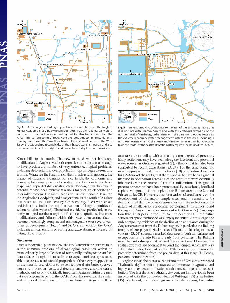
Notably, amongst a variety of significant outcomes, the mappinghas resulted in the identification of two massive earthen structures,whose precise function remains unclear, east of the East Baray andto the southwest of Phnom Dei 1 (Figs. 4 and 5). Eventually, severalthousand individual features (mostly ponds) were mapped as partof this process. A large number of these features do not appear inprevious maps or within existing site inventories, including, for
‡‡Kummu, M., 5th World Archaeological Congress, June 21–26, 2003, Washington, DC,available at http://users.tkk.fi/�mkummu/publications/kummu_WAC_WashingtonDC_2003.pdf.
Evans et al. PNAS � September 4, 2007 � vol. 104 � no. 36 � 14279
AN
THRO
POLO
GY
example, 79 linear features and 94 local temples. The class of ‘‘linearfeature’’ is used here in preference to a specific identification asroadway or canal, because a careful analysis of the available remotesensing data, and of the radar data in particular, supports Groslier’s(1) observation that many of the linear features were multipurpose.In the extremely flat topography of the Angkor plain, an elevated
roadway inevitably obstructed and/or channelled water on itsupslope side, and the elevated banks of canals would have been usedas convenient routes of transportation and locations for residentialdevelopment, especially in view of the extremely waterloggedcondition of the surrounding landscape for part of the year. In rarecases, the linear features are double-banked and were clearlydesigned and used for channelling water. In most cases, however,only one bank would have been required to channel water and/orcreate a road; thus the intended function of linear constructionscannot be categorically limited. The count of newly discoveredtemples represents only those that can be unambiguously identifiedas local temples because of their spatial patterning and/or verifi-cation from pedestrian survey, which has been carried out over partof the study area and is ongoing. The count is also provisional: atthe time of writing, another 74 sites have been identified as likelytemples but require field verification. The increased spatial reso-lution of the source data sets meant that features that were too smallto be mapped using radar alone, such as occupation mounds, couldbe included in the new map of Angkor presented here (Fig. 2),which supersedes the mapping data produced in 2002. Some of thenewly mapped features have been verified only through low-levelaerial survey by using an ultralight plane. The task of verifying thethousands of features identified in the imagery on the ground hasbeen a focus of GAP since 2002 and will continue to occupy fieldworkers for many years to come. This notwithstanding, the newmapping work can generally be considered comparable in terms ofmethodology, content, and detail to the 1999 Pottier map, which itextends.
Even on a quite conservative estimate, Greater Angkor, at itspeak, was therefore the world’s most extensive preindustrial low-density urban complex. This has substantial implications for heri-tage management, as the well-preserved remains of GreaterAngkor extend far beyond the designated World Heritage zone thatsurrounds the central temples. The scale of the site also hasimplications for its history and its demise. Angkor stands in a vastexpanse of rice fields that would have required extensive forestclearance over the entire Angkor plain and up into the Kulen and
Fig. 2. A new archaeological map of Greater Angkor.
Fig. 3. Approximate extent of temple-and-pond-based agricultural settle-ments of the Angkorian and pre-Angkorian periods on the basis of an analysisof Landsat imagery and the spatial coverage of recent archaeological maps.
14280 � www.pnas.org�cgi�doi�10.1073�pnas.0702525104 Evans et al.
Khror hills to the north. The new maps show that landscapemodification at Angkor was both extensive and substantial enoughto have produced a number of very serious ecological problems,including deforestation, overpopulation, topsoil degradation, anderosion. Whatever the functions of the infrastructural network, theimpact of extensive clearance for rice fields, the economic anddemographic consequences of constant modifications to the land-scape, and unpredictable events such as flooding or warfare wouldpotentially have been extremely serious for such an elaborate andinterlinked system. The Siem Reap river is now incised 5–8 m intothe Angkorian floodplain, and a major canal in the south of Angkorthat postdates the 14th century CE is entirely filled with cross-bedded sands, indicating rapid movement of large quantities ofsediment-laden water (8). There is also evidence, particularly in thenewly mapped northern region, of ad hoc adaptations, breaches,modifications, and failures within this system, suggesting that itbecame increasingly complex and unmanageable over several cen-turies of development (Figs. 4 and 5). Current work by the GAP,including annual seasons of coring and excavations, is focused ondating those events.
DiscussionFrom a theoretical point of view, the key issue with the current mapis the common problem of chronological resolution within anextraordinarily large collection of temporally undiagnostic surfacedata (22). Although it is unrealistic to expect archaeologists to beable to excavate a substantial proportion of the newly mapped sitesin the near future, efforts to attach temporal attributes (derivedfrom inscriptions, artifacts, architectural analyses, absolute datingmethods, and so on) to critically important features within the mapdata are ongoing as part of the GAP. From this research, the spatialand temporal development of urban form at Angkor will be
amenable to modeling with a much greater degree of precision.Early settlement may have been along the lakefront and perennialwater sources as Groslier suggested (1), a theory that has also beensupported by recent excavations (23, 24). For the time being, thenew mapping is consistent with Pottier’s (10) observation, based onhis 1999 map of the south, that there appears to have been a gradualincrease in occupation across all of the areas that were eventuallyinhabited over the course of about a millennium. This gradualprocess appears to have been punctuated by occasional, localizedrapid development, for example in the Roluos area in the 8th and9th centuries CE. However, this observation is based largely on thedevelopment of the major temple sites, and it remains to bedemonstrated that the phenomenon is an accurate reflection of thenature of smaller-scale residential development. Ceramics foundthroughout Angkor are also consistent with Groslier’s (1) assump-tion that, at its peak in the 11th to 13th centuries CE, the entiresettlement space as mapped was largely inhabited. At this stage, theonly compelling evidence of the decline of an entire area during theAngkor era comes from the Roluos region, in particular the Bakongtemple, where palynological studies (25) and archaeological exca-vations (23, 24) suggest a marked decrease in both agriculture andoccupation in the late 9th and early 10th centuries. The Bakongmoat fell into disrepair at around the same time. However, thespatial extent of abandonment beyond the temple, which saw verysubstantial redevelopment in the 12th century (26), cannot beprecisely determined from the pollen data at this stage (D. Penny,personal communication).
Angkor meets the material requirements of Groslier’s proposed‘‘hydraulic city’’ in that it possessed an immense, integrated, andhighly complex system of water catchment, storage, and redistri-bution. The fact that the hydraulic city concept has previously beenassociated with the outmoded ideas of Wittfogel (27) is, as Pottier(15) points out, insufficient grounds for abandoning the entire
Fig. 4. An arrangement of eight grid-like enclosures between the Angkor-Phimai Road and Prei Vihear/Phnom Dei. Note that the road partially oblit-erates one of the enclosures, indicating that the structure is older than the(circa 11th- to 12th-century) road. Note the large Angkorian embankmentsrunning south from the Puok River toward the northeast corner of the WestBaray, the size and great complexity of the infrastructure in the area, and alsothe numerous breaches of dykes and embankments by later watercourses.
Fig. 5. An enclosed grid of mounds to the east of the East Baray. Note thatit is isoclinal with Banteay Samre and with the eastward extension of thenorthern wall of the baray, rather than with the baray or its outlet. Note alsothe extremely complex water management system in the area, including anortheast corner entry to the baray and the Krol Romeas distribution outletfrom the center of the east bank of the East Baray into the Roluos River system.
Evans et al. PNAS � September 4, 2007 � vol. 104 � no. 36 � 14281
AN
THRO
POLO
GY
concept and its various implications, especially in light of evidenceemerging from recent archaeological research. Although ground-based archaeological investigations at Angkor are nowhere near asadvanced as at comparable sites in Mesoamerica, for example,surface surveys (10) and excavations (8, 17, 23, 24) have consistentlydemonstrated that the features identified through remote sensingare of Angkorian origin and have the potential to provide crucialdata about the rise and fall of urbanism in this area and the role ofwater management systems in that process.
Around the ponds and the local temples and on the occupationmounds it is now possible to see the fabric of residential lifestretching around and far beyond the infrastructural network. Theareal extent of the urban complex remains to be clarified by detailedanalysis of its network connectivity. What is critical is that thepresent study has affirmed Groslier’s essential propositions aboutthe structure of Angkor and now directs attention to his overallhypothesis that the collapse of Angkor was due to overexploitationof the landscape (1). The discussion of the implications musttherefore be broadened well beyond the prevalent debate aboutwhether or not the network was used to irrigate rice. As Groslierhimself pointed out (1), this aspect of the hydraulic city was just oneamong many, even if it was the one that he elaborated on the mostand that he clearly believed to be the most important.
Although it is important to recognize that certain elements ofAngkor (for example, the temple of Angkor Wat) were neverentirely abandoned, it is nonetheless very clear from the new mapsthat the settlement declined dramatically from a level of highcomplexity in the mid-second millennium AD, and that this con-stitutes a ‘‘collapse’’ by any standard definition (28–30). By pursuingboth the ideas and the methods proposed by Groslier combinedwith innovative techniques, such as airborne radar, the GAP willcontinue to investigate the degree to which the water managementnetwork and the environmental effects of the urban expansion ofAngkor were implicated in that decline.
The size and settlement pattern of Greater Angkor have sub-stantial implications for its management as a cultural resource. The
well preserved remains of the urban complex extend far beyond thedesignated World Heritage zone that surrounds the central temples,highlighting the need to reappraise, in due course, how this re-markable heritage site is to be managed.
The outcomes presented here are also of considerable relevancefor understanding the nature of urban settlements in Southeast Asia(31) and the analysis of past landscapes in the same region (32) andin particular for research on other temple complexes of the 1stmillennium CE in the tropical world. Many of these, like Angkorand the Maya temples, may also lie at the center of previouslyundetected low-density urban settlements that are often obscuredby vegetation or modern settlements. The key sites to be examinedin South and Southeast Asia include Pagan in Myanmar, Anuradha-pura and Pollonuruwa in Sri Lanka, Borobudur and Prambanan inIndonesia, Sukhothai in Thailand, Sambor Prei Kuk and Koh Kerin Cambodia, and My Son in Vietnam. Although there may proveto be no substantial occupation around the monuments at thesesites, further analysis is critical, because similar discoveries in theselocations would transform our understanding of their social, cul-tural, and environmental contexts in much the same way as hashappened for the Maya settlements and now for Angkor. This, inturn, will provide a foundation for comparative studies of the greatcities that emerged and then collapsed in fragile tropical ecosys-tems, an important and topical field of research that has receivedminimal attention thus far.
We thank Dan Penny, Terry Lustig, Andrew Black, and Michael Coe fortheir comments on drafts of this paper; Bruce Chapman of the JetPropulsion Laboratory for his work on processing the radar data; andDonald Cooney, Eddie Smith, Alexandra Rosen, and the crew of theAngkor Ultralight Survey Group for their support of this project. Fundingwas principally from the Australian Research Council but also from theMekong River Commission, the University of Sydney, l’Ecole Francaised’Extreme-Orient, the Authority for the Protection and Management ofAngkor and the Region of Siem Reap, the Carlyle Greenwell Bequest(D.E.), and the Iain A. Cameron Memorial Travel Grant Fund (D.E.).
1. Groslier B-P (1979) Bull Ec Fr Extreme-Orient 66:161–202.2. Groslier B-P (1958) Angkor et le Cambodge au XVIe Siecle d’Apres les Sources
Portugaises et Espagnoles (Press Univ France, Paris).3. Groslier B-P (1956) Sciences et Voyages 125:24–28.4. Groslier B-P (1970) Indochina (Barrie & Jenkins, London).5. Groslier B-P (1962) Programme de Recherches Urgentes a Angkor (Ecole
Francaise d’Extreme-Orient, Siem Reap, Cambodia).6. Pottier C, Dumarcay J (1993) Documents Topographiques de la Conservation des
Monuments d’Angkor (Ecole Francaise d’Extreme-Orient, Paris).7. Evans DH (2002) BA Honors thesis (University of Sydney, Sydney).8. Fletcher RJ, Barbetti M, Evans D, Than H, Sokrithy I, Chan K, Penny D,
Pottier C, Somaneath T (2003) Udaya 4:107–121.9. Pottier C (1994) in Southeast Asian Archaeology 1994: Proceedings of the 5th
International Conference of the European Association of Southeast Asian Ar-chaeologists, Paris 24th–28th October 1994, ed Manguin P-Y (Centre forSoutheast Asian Studies, Hull, UK), pp 179–194.
10. Pottier C (1999) PhD thesis (Universite Paris III, Sorbonne Nouvelle, Paris).11. Van Liere WJ (1980) World Archaeol 11:265–280.12. Acker R (1998) South East Asia Res 6:5–47.13. Higham C (2001) The Civilisation of Angkor (Weidenfeld & Nicolson, London).14. Pottier C (2001) Aseanie 8:167–176.15. Pottier C (2000) J Sophia Asian Stud 18:1–21.16. Chou Ta-Kuan (1993) The Customs of Cambodia. (The Siam Society, Bangkok,
Thailand).17. Baty P (2005) Extension de l’Aeroport de Siem Reap 2004: Rapport de Fouille
Archeologique (Authority for the Protection and Management of Angkor andthe Region of Siem Reap–Institut National de Recherches ArcheologiquesPreventives, Siem Reap, Cambodia).
19. Fletcher RJ, Evans DH, Tapley IJ (2002) in Proceedings of the 2002 AIRSAREarth Science and Application Workshop, NASA/JPL (National Aeronautics andSpace Administration, Pasadena, CA), Available at http://airsar.jpl.nasa.gov/documents/worshop2002/papers/P1.pdf.
20. Coe M (1957) Am Antiquity 22:409–410.21. Puleston DE (1983) The Settlement Survey of Tikal (The University Museum,
University of Pennsylvania, Philadelphia).22. Ashmore W (1981) in Lowland Maya Settlement Patterns, ed Ashmore W (Univ
New Mexico Press, Albuquerque), pp 37–69.23. Pottier C, Bolle A, Chhem RK, Demeter F, Gabillault C, Guerin A, Than H,
Chan K, Latinis K, Boer-Mah T, et al. (2004) Mission Archeologique Franco-Khmere sur l’Amenagement du Territoire Angkorien (MAFKATA): RapportPreliminaire sur la Campagne de Fouilles 2004 (Authority for the Protection andManagement of Angkor and the Region of Siem Reap–Ministere des AffairesEtrangeres (France)–l’Ecole Francaise d’Extreme-Orient, Siem Reap,Cambodia).
24. Pottier C, Bolle A, Llopis E, Soutif D, Tan C, Chevance JB, Vireak K,Socheat C, Sang S, Demeter F et al (2005) Mission Archeologique Franco-Khmere sur l’Amenagement du Territoire Angkorien (MAFKATA): Rapportpreliminaire sur la campagne de fouilles 2005 (Authority for the Protectionand Management of Angkor and the Region of Siem Reap– Ministere desAffaires Etrangeres (France)–l’Ecole Francaise d’Extreme-Orient, SiemReap, Cambodia).
26. Boisselier J (1952) Bull Ec Fr Extreme-Orient 46:187–238.27. Wittfogel KA (1957) Oriental Despotism: A Comparative Study of Total Power
(Yale Univ Press, New Haven, CT).28. Diamond JM (2005) Collapse: How Societies Choose to Fail or Succeed
(Penguin, New York).29. Tainter JA (1988) The Collapse of Complex Societies (Cambridge Univ. Press,
Cambridge, UK).30. Yoffee N (1988) in The Collapse of Ancient States and Civilizations, eds Yoffee
N, Cowgill GL (University of Arizona Press, Tucson), pp 1–19.31. Miksic JN (2000) World Archaeol 32:106–120.32. Stark M (2006) Annu Rev Anthropol 35:407–432.
14282 � www.pnas.org�cgi�doi�10.1073�pnas.0702525104 Evans et al.