Pure appl. geophys. 157 (2000) 185–204 0033 – 4553/00/020185–20 $ 1.50 +0.20/0 A Contribution to Seismic Hazard Assessment in Croatia from Deterministic Modeling S. MARKUS ˇ IC ´ , 1 P. SUHADOLC, 2 M. HERAK 1 and F. VACCARI 2 Abstract — Some of the elements of regional seismic hazard in Croatia are assessed by computing synthetic accelerograms at a predetermined set of sites. The input dataset consists of structural models, parameters of seismic sources, and an updated earthquake catalog. Synthetic strong-motion time series for frequencies below 1 Hz are computed on a grid of sites using the modal summation technique. The long-period hazard is described by the distribution of estimated peak values of ground displacement, velocity and acceleration, while the short-period hazard is represented by the map of design ground acceleration values (DGA). The highest values of DGA exceeding 0.35 g on the base-rock level are found in the southeastern coastal part of the country, in the greater Dubrovnik area. Key words: Seismic hazard, deterministic modeling, synthetic seismograms, Croatia. 1. Introduction Traditionally seismic zoning has been one of the most important elements of post-earthquake surveying, proving essential in choosing which urban and non-ur- ban areas are most safe or best suited to the development of new settlements. The recent guidelines of the United Nations sponsored International Decade for Natu- ral Disaster Reduction (IDNDR) for the preparation of pre-catastrophe plans of action, enforce the idea that zoning and related seismic hazard assessment can and must be used as means of prevention in areas that have not yet been struck by disaster but are potentially prone to it. The first scientific and technical methods developed for seismic zoning were deterministic and based on the observation that damage distribution is often correlated to the spatial distribution and physical properties of the underlying terrain and rocks (see REITER, 1990). The deterministic approach to earthquake hazard assessment as used here was developed by COSTA et al. (1993) for seismic zoning of the Italian territory, and was subsequently used for the zoning of Bulgaria (OROZOVA-STANISHKOVA et al., 1996a) and Algeria (AOUDIA et al., 1 Department of Geophysics, Faculty of Sciences, University of Zagreb, Horvatovac bb, 10000 Zagreb, Croatia. 2 Department of Earth Sciences, University of Trieste, Via E. Weiss 1, 34127 Trieste, Italy.
Transcript
Pure appl. geophys. 157 (2000) 185–2040033–4553/00/020185–20 $ 1.50+0.20/0
A Contribution to Seismic Hazard Assessment in Croatia fromDeterministic Modeling
S. MARKUSIC,1 P. SUHADOLC,2 M. HERAK1 and F. VACCARI2
Abstract—Some of the elements of regional seismic hazard in Croatia are assessed by computingsynthetic accelerograms at a predetermined set of sites. The input dataset consists of structural models,parameters of seismic sources, and an updated earthquake catalog. Synthetic strong-motion time seriesfor frequencies below 1 Hz are computed on a grid of sites using the modal summation technique. Thelong-period hazard is described by the distribution of estimated peak values of ground displacement,velocity and acceleration, while the short-period hazard is represented by the map of design groundacceleration values (DGA). The highest values of DGA exceeding 0.35 g on the base-rock level are foundin the southeastern coastal part of the country, in the greater Dubrovnik area.
Traditionally seismic zoning has been one of the most important elements ofpost-earthquake surveying, proving essential in choosing which urban and non-ur-ban areas are most safe or best suited to the development of new settlements. Therecent guidelines of the United Nations sponsored International Decade for Natu-ral Disaster Reduction (IDNDR) for the preparation of pre-catastrophe plans ofaction, enforce the idea that zoning and related seismic hazard assessment can andmust be used as means of prevention in areas that have not yet been struck bydisaster but are potentially prone to it.
The first scientific and technical methods developed for seismic zoning weredeterministic and based on the observation that damage distribution is oftencorrelated to the spatial distribution and physical properties of the underlyingterrain and rocks (see REITER, 1990). The deterministic approach to earthquakehazard assessment as used here was developed by COSTA et al. (1993) for seismiczoning of the Italian territory, and was subsequently used for the zoning ofBulgaria (OROZOVA-STANISHKOVA et al., 1996a) and Algeria (AOUDIA et al.,
1 Department of Geophysics, Faculty of Sciences, University of Zagreb, Horvatovac bb, 10000Zagreb, Croatia.
2 Department of Earth Sciences, University of Trieste, Via E. Weiss 1, 34127 Trieste, Italy.
S. Markusic et al.186 Pure appl. geophys.,
1998). The procedure is based on computation of complete synthetic seismogramsusing the modal summation technique (PANZA, 1985; FLORSCH et al., 1991) on apredetermined grid of sites. The heterogeneity of the shallow earth structure in theregion along with specific properties of individual seismic sources (or source zones)make reliable prediction of near-field waveforms using statistical methods animpossible task. The use of synthetic seismograms enables estimation of all engi-neering parameters needed to assess the seismic hazard, even in areas where scarce(or no) historical or instrumental information is available (e.g., AOUDIA et al.,1998). Since the computation is transparent at each step, it is possible to evaluatethe influence of each parameter on the final result. Moreover, the use of informa-tion concerning source mechanism and of available structural models of the region,by computing wave generation, propagation and attenuation, overcomes one of themajor sources of uncertainty in probabilistic computations, i.e., the use of empiricalattenuation laws, which are usually derived for quite different tectonic and struc-tural settings and in most cases uncritically adopted. Deterministic methods also donot require catalog completeness, since only the strongest events (i.e., controllingearthquakes) of an area are considered. On the other hand no frequency ofoccurrence is taken into account. Deterministic hazard assessment results can becompared to probabilistic results only when these are computed for very largereturn periods.
Here we estimate the maximal displacements, velocities and accelerations in theCroatian and near-by territories that have been caused by previous earthquakes.Using the same procedure one could take into account the rate of earthquakeoccurrence within the specific seismogenic source zone (OROZOVA-STANISHKOVA etal., 1996b) in order to obtain the ground-motion parameters corresponding tovarious risk levels and return periods.
2. Input Data
The computed synthetic seismograms are as good as is our knowledge of thesource and propagation effects. Therefore, parameters describing seismic sourcesand structural models must be carefully defined and assigned to the studied area.The input data set consists of four main subsets. They are: i) structural modelsinside regional polygons, ii) seismogenic source zones, iii) characteristic fault planesolutions, and iv) the earthquake catalog (see the flow-chart scheme in Fig. 1). Abrief description of each of them for the territory of Croatia is given below.
2.1 Structural Models
The structural models are defined within regional polygons separating areascharacterized by different lithospheric properties. Structural models are represented
Modeling of Seismic Hazard Elements in Croatia 187Vol. 157, 2000
by a number of flat layers, each of which is described by its thickness, density, P-and S-wave velocities and anelastic attenuation. Since the computation is aimed ata first-order seismic zonation, the structural models do not explicitly account forlocal site effects, and are representative of the average properties within eachpolygon. In order to propose a suitable structural model, all available geophysicaland geological information for the investigated territory must be considered. Sinceto date only the areas of the southern Adriatic and Dinarides have been investi-gated in some detail (HERAK, 1990; MARKUSIC, 1991; HERAK and HERAK, 1995),it was necessary to determine the crustal and uppermost mantle body-wave velocitymodels for the entire region studied.
For this purpose, the Croatian territory is divided into eight regional polygons(Fig. 2). Their borders are defined on the basis of specific geological properties andthe local topography of the Moho discontinuity. Here, the velocity models are
Figure 1Flow-chart scheme of the seismic hazard assessment procedure used (after COSTA et al., 1993).
S. Markusic et al.188 Pure appl. geophys.,
Figure 2Boundaries of regional polygons to which structural models are assigned.
obtained for polygons 1–6, while the models for the remaining two were defined onthe basis of results obtained within the framework of the CIPA-CT94-0238 project:‘‘Quantitative seismic zoning of the Circum-Pannonian region’’ Z& IVCIC et al., thisissue; BUS and VACCARI, this issue).
The method for the determination of body-wave velocities is basically the onedescribed for the External Dinarides area by HERAK and HERAK (1995). Theprerequisite is the availability of a large data set of reliable locations of earthquakefoci, together with associated onset times of various phases at regional and localseismic stations. Therefore, it was decided to relocate all relevant events (a total of3434) by quasi-simultaneous inversion of the hypocentral coordinates and theso-called inter-area model parameters that control the shape of theoretical travel-
Modeling of Seismic Hazard Elements in Croatia 189Vol. 157, 2000
time curves (see HERAK and HERAK, 1995, for details). The resulting inter-areamodels are rather simple (three layers with non-horizontal interfaces over ahalfspace), each of them representing average properties of the crust and uppermantle between the chosen epicentral area and a particular group of seismicstations. Their purpose is to simulate lateral heterogeneity of the lithosphere in thearea, enabling more accurate earthquake locations. The final locations were ob-tained after eight cycles involving earthquake location, model parameters, adjust-ments and station correction computations (for 598 phase-station pairs).
The final event locations, together with the corresponding phase onset times,constitute the input data set for intra-area velocity computations (the term intra-area—taken from HERAK and HERAK (1995)—denotes velocities within each ofthe regional polygons). The method employed considers all possible pairs of traveltimes observed at some stations for earthquakes within the selected polygon. If Mstations reported arrival times for a total of K earthquakes, the velocity 6 in theepicentral region is estimated as
6=Sd/St,
where
Sd= %K
i=1
%K
j=1
%M
m=1
(di,m−dj,m), St= %K
i=1
%K
j=1
%M
m=1
(ti,m− tj,m)
are the sum of differences of raypaths (di,m) and travel times (ti,m), respectively, forall possible pairs of earthquakes within each of the polygons. Indices i and j denoteearthquakes, while m corresponds to stations. The method is fully described inHERAK and HERAK (1995). The original algorithm was slightly modified to allowthe consideration of events within a given depth range, thus enabling estimation ofthe local velocity-depth profiles. When onset times of direct phases (such as Pg andSg) are considered, only the velocities within the seismogenic layer (up to the depthof about 20 km in Croatia) may be estimated. The use of refracted waves (Pb, Sb,Pn and Sn) yields velocities representative of the uppermost parts of the lower crustand the upper mantle. For the upper crust, the velocities were estimated in a stackof overlapping layers whose thickness varied between 2 and 10 km, depending onthe number of hypocenters located within each of them. Only the velocities with astandard error less than 90.03 km/s were accepted. In very few cases, when thisthreshold was exceeded, the velocity for this particular layer was obtained by linearinterpolation. In the case of polygons 2–6, the values of computed body-wavevelocities in the topmost layer were either too high (5.70–6.18 km s−1 for P-waves,probably due to dislocation of shallow foci), or there were not enough data toreliably estimate them. To obtain more realistic distribution of near-surface veloc-ities, the uppermost layer in each of the mentioned polygons was subdivided intofive thin layers. Velocities in these five layers were arbitrarily assumed as 60%, 75%,90% and 100% of the values originally determined. Final velocity models for all
S. Markusic et al.190 Pure appl. geophys.,
regional polygons are presented in Table 1. It is assumed that mantle velocitiesbelow the last layer given in the table equal those in the IASP91 global model(KENNETT and ENGDAHL, 1991) while the density and quality factors are takenfrom the PREM model (DZIEWONSKI and ANDERSON, 1981). The densities in thecrust are assumed to increase from 2500 kg/m3 near the surface to 2800 kg/m3 atthe bottom of the crust. The models may be regarded as representative of thestructure up to the base-rock level only. Modeling of the shallowest soil layerswould require more detailed analyses on a considerably smaller scale than is thecase here.
Table 1
Intra-area seismic 6elocity models within eight regional polygons in Croatia. a [km/s] and b [km/s] are P-and S-wa6e 6elocities in the layer of thickness h [km]. See text for details.
Modeling of Seismic Hazard Elements in Croatia 191Vol. 157, 2000
Figure 3Seismogenic source zones in Croatia (after MARKUSIC and HERAK, 1999).
Numerical experiments indicated that even small changes of assumed veloc-ities may have considerable influence on the final modeling. This is especiallytrue for the topmost layers whose average properties are poorly known. Thereliability of modeling will thus critically depend on the quality and representa-tiveness of structural models, which fact must be borne in mind when applyingour results.
2.2 Seismogenic Source Zones
Delineation of seismogenic source zones is the final result of the seismotec-tonic zoning of a certain territory. Source zones are characterized by a specifictectonic, geodynamic and seismic behavior, which is assumed to be homogeneouswithin the zone. On the basis of local and regional seismicity, geology and
S. Markusic et al.192 Pure appl. geophys.,
tectonics, MARKUSIC and HERAK (1999) proposed seismotectonic zoning of Croa-tia consisting of 17 seismogenic zones (Fig. 3), which is adopted herein withmodification of zones 13 and 14 in order to also take into account the events acrossthe Hungarian border.
2.3 Fault-plane Solutions
Characteristic fault plane solutions were defined mostly on the basis of datapresented in HERAK et al. (1995) and the Harvard CMT database. The direction oftectonic stresses, as well as geological data on the strike, dip and rake of activefaults were also taken into account, especially for the zones with only a few or nofault-plane solutions available. Table 2 lists the strike (8), dip (d) and rake (l) ofthe characteristic focal mechanisms (for each seismogenic source zone SZ1–SZ17)that are used as input data (see also Fig. 4).
2.4 Earthquake Catalog
The earthquake catalog used for the seismicity analysis was prepared on thebasis of the revised Croatian earthquake catalog CEC92 (HERAK et al., 1996) which
Table 2
The parameters of fault plane solutions (strike—8, dip—d and rake—l, indegrees) characteristic for each seismogenic zone (SZ1–SZ17).
8 d l
127 77SZ1 85SZ2a 310 36 130SZ2b 270 60 0
11458310SZ399 47SZ4 102
SZ5 286 61 2211842323SZ6
46310 120SZ7SZ8 17056340
336 84 180SZ9SZ10 300 36 110
43 33964SZ11a322 79 0SZ11b
SZ12 1005612072SZ13 46 11
43 339SZ14 6490 90 0SZ15
267 55 22SZ1612159SZ17 284
Modeling of Seismic Hazard Elements in Croatia 193Vol. 157, 2000
Figure 4Characteristic fault-plane solutions within seismogenic zones.
has been supplemented with data for the years 1993–1996 (Fig. 5). It spans theperiod BC–1996, and may be considered complete for M\4 for the entire 20thcentury. This threshold decreases in the last few decades of this century to about3.6. The pre-instrumental part of the catalog has been compiled by many authorsby searching and evaluating historical sources, and its completeness is difficult toassess. The rate of occurrence of large events (M]6.0) estimated from the catalogis almost constant for the last 1000 years (1 event in approximately 30 years). Wetherefore believe that the catalog is reasonably complete at this level for the lastmillennium, which is adequate for deterministic hazard studies. The earthquakeshave been assigned a local magnitude as listed in the catalog. In the case of eventswithout magnitude, but with a reported intensity, the magnitude has been estimatedusing the magnitude-intensity-depth relation proposed by HERAK (1989). Further-more, only main shocks shallower than 30 km were considered. The aftershockswere removed from the catalog by the algorithm suggested by KEILIS-BOROK et al.(1980).
S. Markusic et al.194 Pure appl. geophys.,
3. Computations
In order to obtain a more robust distribution of the maximum observedmagnitude over the Croatian territory, the image of the seismicity given by theearthquake catalog had to be smoothed. First, the area is subdivided into 0.2°×0.2° cells and the magnitude of the strongest earthquake that occurred within a cellis assigned to it. However, it was found that not each cell contains a statisticallymeaningful number of events. For that reason the maximum magnitude to beassigned to each cell is also searched for in the surrounding cells, applying theprocedure of a centered smoothing window (COSTA et al., 1993). This procedurecan also partly account for the source dimensions of the largest earthquakes. Onlythe cells located inside each of the seismogenic zones are retained for the definitionof the seismic sources that are used to generate the synthetic seismograms. Theresult of the application of this method to the updated CEC92 earthquake catalogis shown in Figure 6. As can be seen, after the smoothing a magnitude exceeding5.5 is assigned to the majority of cells.
The seismic source is represented by a double-couple point source placed in thecenter of each cell and it replaces all the events falling within it. Its ‘‘strength’’ is
Figure 5Epicenters of all earthquakes in Croatia and neighboring regions for the period BC–1996.
Modeling of Seismic Hazard Elements in Croatia 195Vol. 157, 2000
Figure 6Representation of the ‘‘smoothed’’ seismicity within each seismogenic zone.
determined according to the maximum magnitude assigned to the cell. The orienta-tion of the double-couple point source is made consistent with the predefinedcharacteristic fault plane solution.
It is assumed that the hypocentral depth is variable, depending on the earth-quake magnitude. For earthquakes with M57.0 the hypocentral depth is fixed at10 km, while for those with M]7.0 it is set equal to 15 km. This assumption isjustified by the large errors affecting the hypocentral depth estimates and by thefact that strong ground motion is mainly controlled by shallow sources (e.g.,VACCARI et al., 1990). The chosen depths of the sources are representative for theCroatian seismicity (HERAK and HERAK, 1990).
Once the structural models and the seismic sources are defined, sites areconsidered on a grid (0.2°×0.2°) covering the whole territory under investigation,and synthetic seismograms are computed at each of them by the modal summationtechnique (PANZA, 1985; FLORSCH et al., 1991). The modeling accounts not onlyfor surface waves, but also for all those body waves which have phase velocities lessthan the S-wave velocity of the halfspace. For the velocity models used in ourpaper, this ensures the presence of the most energetic S-waves in the seismograms.
S. Markusic et al.196 Pure appl. geophys.,
Sources and sites do not overlap, as the sources are placed in the center of each cell,whereas the sites are placed at the cell corners. As a result, the shortest source toreceiver distance is about 13.5 km. The synthetic signals are computed for frequen-cies up to 1 Hz, for which the point-source approximation is assumed to be stillvalid. If shorter periods are to be considered, the finite dimensions of the faultcannot be neglected and the rupturing process at the source must be allowed for,which is beyond the scope of this study.
To reduce the number of computed seismograms, the epicentral (source-site)distance is kept below an upper threshold, which is considered to be a function ofmagnitude associated with the source (COSTA et al., 1993). The maximum epicentraldistance is set equal to 25, 50 and 90 km for MB6, 65M57 and M\7,respectively.
At each site the P-SV (radial and vertical components) and SH (transversecomponent) synthetic seismograms are first computed for a seismic moment of10−7 Nm. The amplitudes of the synthetic seismograms are then scaled accordingto the smoothed magnitude associated with the cell of the source, using themoment-magnitude relation as given by KANAMORI (1977) and the spectral scalinglaw proposed by GUSEV (1983) as reported in AKI (1987), which implicitly containssome finite-fault effects. In the case were a source-site path crosses one or moreboundaries between structural models, the site’s structural model is chosen alongthe entire path. In this 1-D approximation the site’s structural model is chosenalong the entire path, since the station records are usually more sensitive to thelocal structural conditions. The horizontal components at each site are first rotatedinto a reference system common to the whole territory (N–S and E–W directions)and then their vector sum is calculated. The resulting signal characterized by thelargest amplitude due to any of the surrounding sources is selected and associatedwith that particular site.
The accelerograms obtained as outlined above are not suitable to be used for anoverall earthquake risk estimation, as they only provide information on strongground motion for periods above 1 s. They can, however, be used for estimation ofthe long-period risk, i.e., in those cases when one deals with objects whose naturalperiods lie above 1 s.
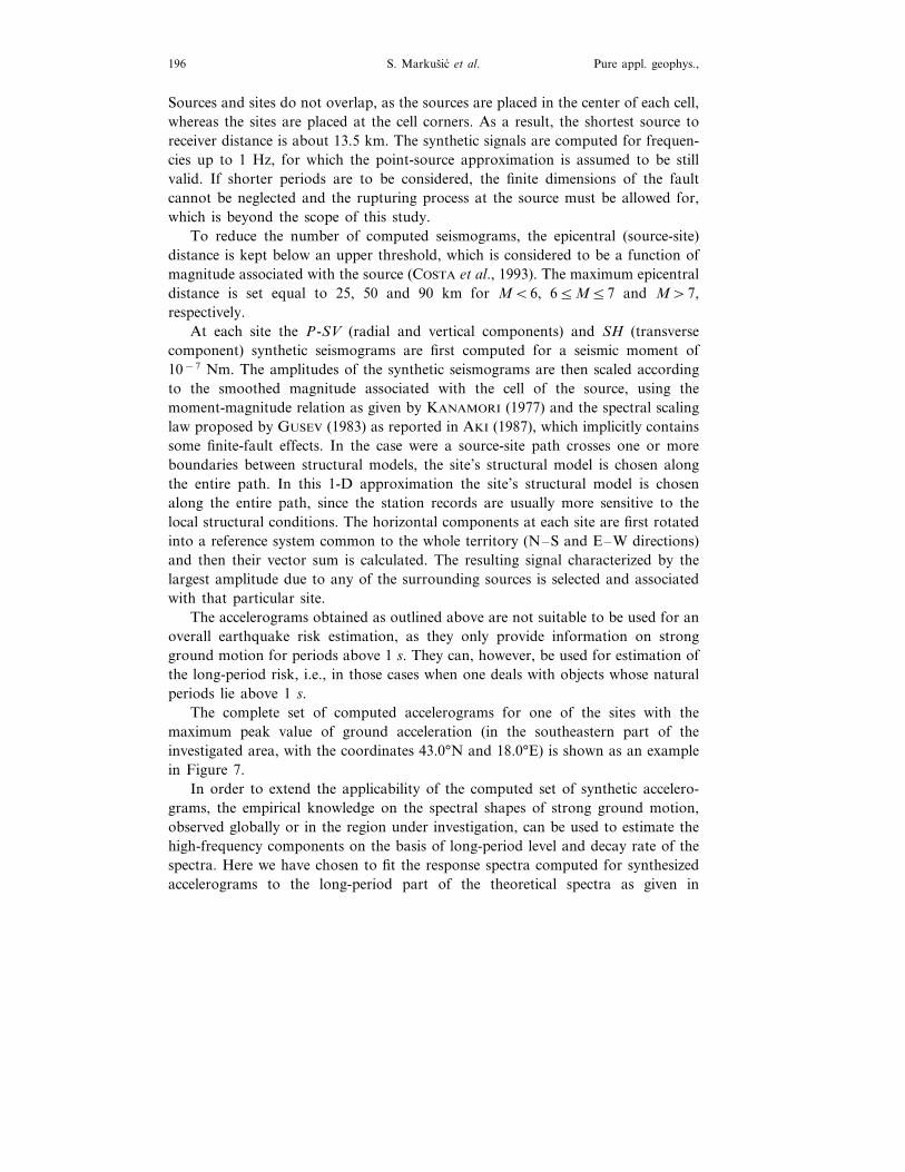
The complete set of computed accelerograms for one of the sites with themaximum peak value of ground acceleration (in the southeastern part of theinvestigated area, with the coordinates 43.0°N and 18.0°E) is shown as an examplein Figure 7.
In order to extend the applicability of the computed set of synthetic accelero-grams, the empirical knowledge on the spectral shapes of strong ground motion,observed globally or in the region under investigation, can be used to estimate thehigh-frequency components on the basis of long-period level and decay rate of thespectra. Here we have chosen to fit the response spectra computed for synthesizedaccelerograms to the long-period part of the theoretical spectra as given in
Modeling
ofSeism
icH
azardE
lements
inC
roatia197
Vol.
157,2000
Figure 7Complete set of accelerograms computed for the site (43.0°N, 18.0°E) with the highest peak ground acceleration within the studied region. The valuesreported in the right upper corner of each trace are (from top to bottom): peak acceleration (in cm/s2), epicentral distance (in km) and azimuth (in degrees)
of the source-site line.
S. Markusic et al.198 Pure appl. geophys.,
Figure 8Determination of the Design Ground Acceleration (DGA). The shape of the EUROCODE 8 designspectrum for stiff soils (thin line) is used to complete the synthetic response spectrum (thick gray line)
at short periods. DGA is the intercept of the curve at T=0 s.
Figure 9Spatial distribution of (a) peak ground displacement in cm, (b) velocity in cms−1, (c) acceleration in %
of g (all for periods exceeding 1 s), and (d) design ground acceleration −DGA in % of g.
Modeling of Seismic Hazard Elements in Croatia 199Vol. 157, 2000
Fig. 9, cont.
EUROCODE 8 (1993). The period range in which the fit is searched is a functionof the magnitude of the event (1–2 s for M56; 2–3 s for 6BM57; 3–5 s forM\7). The example shown in Figure 8 refers to the strongest DGA obtained forCroatia, due to a M=7.4 event, thus the fit is searched between T=3 s and T=5s and the design spectrum is used to complete the synthetic one from T=3 s toT=0 s. In this way we define representative response spectra (RRS) for our set ofsite locations, and we may further define design ground acceleration (DGA) as theT=0 s intercept of the corresponding RRS. The DGA is therefore the estimate ofthe peak acceleration (PGA) of the unfiltered accelerogram. The same procedurehas been used by VACCARI et al. (1995) and PANZA et al. (1996), and has beenvalidated empirically against recorded ground motions due to the Friuli 1976 andIrpinia 1980 earthquakes (PANZA et al., 1996).
S. Markusic et al.200 Pure appl. geophys.,
Fig. 9, cont.
4. Results and Conclusions
Spatial distribution of peak ground displacement, velocity and acceleration (forperiods exceeding 1 s), and the design ground acceleration (DGA) are presented inFigures 9a–d. It is seen that all parameters are the largest in SE Dalmatia, with thehighest values in the greater Dubrovnik area. The DGA there exceeds 0.35 g on thebase-rock level. High DGA values are also estimated in northern Croatia (greaterZagreb region), in the southern part of the Pannonian Basin (due to seismicity ofthe Banja Luka area), and in the NW coastal parts of the country (Rijeka andnorthern Istria). The rest of the Croatian territory is characterized by DGA valuesless than 0.1 g on the base-rock level.
In order to compare the performance of the deterministic method as describedhere with the traditional technique, the peak horizontal ground acceleration isestimated by applying the empirical acceleration attenuation function GZ300(PRELOGOVIC et al., 1985) to the same set of sources and receivers as used above(Fig. 10). The GZ300 relation was derived for earthquakes in this region, and it
Modeling of Seismic Hazard Elements in Croatia 201Vol. 157, 2000
Fig. 9, cont.
yields expected maximal horizontal acceleration on average soil, given the magni-tude and hypocentral distance. Comparison of Figure 9d and Figure 10 reveals thatGZ300 yields higher values of peak acceleration than DGA by a factor of about1.5–3 in most cases. This is due to local amplification effects, and is in agreementwith the conclusion of MARKUSIC (1997) that the GZ300 relation includes anaverage amplification factor of about 2 relative to the base-rock level. Thediscrepancies are mostly within the 1-sigma confidence limits of the GZ300 estima-tion (90.3 g for the logarithm of the estimated value). The major differencesbetween GZ300 and DGA estimates are found for zones 5, 7 15 and 16 (Fig. 3).They are most probably caused either by possible errors in velocity models, or bythe choice of the representative faulting mechanism (Fig. 4).
Computation of realistic synthetic seismograms for the Croatian territoryyielded meaningful results, thus providing us with a powerful and economicallyvalid scientific tool for seismic zonation and hazard assessment. The main advan-tage of the method lies in its ability to directly estimate the effects of source
S. Markusic et al.202 Pure appl. geophys.,
mechanics and wave propagation, while local soil effects are roughly consideredwhen using the design spectra to obtain the DGA from the synthetic responsespectra. The results are especially useful for large constructions, which have aresponse spectrum peaked at values below 1 Hz. Furthermore, as the complete timeseries is computed at each site, it is possible to consider other parameters (such asthe Arias intensity, or other integral quantities) of interest in seismic engineering.The limitations of the proposed procedure are mainly related to the need of DGAestimation by way of response spectra extrapolation to low frequencies. This maybe overcome by extending the frequency interval considered, which makes itnecessary to drop the point-source assumption and deal with realistic extendedsources, whose characteristics are generally not known with the required detail.Furthermore, due to a substantial increase of computation time, this is a viablepossibility only in the framework of hazard assessment of a considerably smallerarea than is the case here.
Figure 10Peak horizontal accelerations in Croatia estimated using the empirical GZ300 relation (in % of g).
Modeling of Seismic Hazard Elements in Croatia 203Vol. 157, 2000
Acknowledgements
We wish to thank two anonymous reviewers for their constructive criticism ofthe manuscript. The study was supported by the Commission of European Commu-nities Programme COPERNICUS ‘‘Quantitative Seismic Zoning of the Circum-Pannonian Region’’ (contract No. CIPA-CT94-0238), and by the Ministry ofScience and Technology of the Republic of Croatia, grants No. 119298 and No.119297.
REFERENCES
AKI, K., Strong motion seismology. In Strong Ground Motion Seismology, NATO ASI Series, Series C:Mathematical and Physical Sciences (eds. Erdik, M. O8 ., and Toksoz, M. N.) (D. Reidel Pub. Co.,Dordrecht 1987), 204, 3–39.
AOUDIA, A., VACCARI, F., SUHADOLC, P., and MEGHRAOUI, M. (1998), Seismogenic Potential andEarthquake Hazard Assessment in the Tell Atlas of Algeria, J. Seismology, submitted.
BUS, Z., and VACCARI, F. (this issue), Synthetic Seismogram Based on the Deterministic Estimation ofPeak Ground Acceleration for the Hungarian Part of the Pannonian Basin, this issue.
COSTA, G., PANZA, G. F., SUHADOLC, P., and VACCARI, F. (1993), Zoning of the Italian Territory inTerms of Expected Peak Ground Acceleration Deri6ed from Complete Synthetic Seismograms, J. Appl.Geophys 30, 149–160.
DZIEWONSKI, A. M., and ANDERSON, D. L. (1981), Preliminary Reference Earth Model, Phys. EarthPlanet. Inter. 25, 297–356.
EUROCODE 8 (1993), Eurocode 8 Structures in Seismic Regions—Design—Part 1 General and Building,Doc TC250/SC8/N57A.
FLORSCH, N., FAH, D., SUHADOLC, P., and PANZA, G. F. (1991), Complete Synthetic Seismograms forHigh-frequency Multimode Lo6e Wa6es, Pure appl. geophys. 136, 529–560.
GUSEV, A. A. (1983), Descripti6e Statistical Model of Earthquake Source Radiation and its Application toan Estimation of Short-period Strong Motion, Geophys. J. R. Astron. Soc. 74, 787–800.
HERAK, D., and HERAK, M. (1990), Focal Depth Distribution in the Dinara Mt. Region, GerlandsBeitrage zur Geophysik 99, 505–511.
HERAK, D., and HERAK, M. (1995), Body-wa6e Velocities in the Circum-Adriatic Region, Tec-tonophysics 241, 121–141.
HERAK, M. (1989), The Magnitude-intensity-focal Depth Relation for the Earthquakes in the WiderDinara Region, Geofizika 6, 13–21.
HERAK, M. (1990), Velocities of Body Wa6es in the Adriatic Region, Boll. Geofis. Teor. Appl. XXXII125, 11–18.
HERAK, M., HERAK, D., and MARKUSIC, S. (1995), Fault-plane Solutions for Earthquakes (1956–1995)in Croatia and Neighbouring Regions, Geofizika 12, 43–56.
HERAK, M., HERAK, D., and MARKUSIC, S. (1996), Re6ision of the Earthquake Catalogue and Seismicityof Croatia, 1908–1992, Terra Nova 8, 86–94.
KANAMORI, H. (1977), The Energy Release in Great Earthquakes, J. Geophys. Res. 82, 2981–2987.KEILIS-BOROK, V. I., KNOPOFF, L., ROTWAIN, I. M., and SIDORENKO, T. M. (1980), Bursts of
Seismicity as Long-term Precursors of Strong Earthquakes, J. Geophys. Res. 85, 803–812.KENNETT, B. L. N., and ENGDAHL, E. R. (1991), Tra6el Times for Global Earthquake Location and
Phase Identification, Geophys. J. Int. 105, 429–465.MARKUSIC, S. (1991), Velocities of Refracted Longitudinal Pn Wa6es in the Dinarides Area, Geofizika 8,
101–113 (in Croatian with English abstract).MARKUSIC, S. (1997), Deterministicko seizmicko zoniranje Hr6atske postupkom racunanja sintetickih
seizmograma, Ph.D. Thesis, University of Zagreb (in Croatian with English abstract), pp. 149.
S. Markusic et al.204 Pure appl. geophys.,
MARKUSIC, S., and HERAK, M. (1999), Seismic Zonation of Croatia, Natural Hazards 18, 269–285.OROZOVA-STANISHKOVA, I. M., COSTA, G., VACCARI, F., and SUHADOLC, P. (1996a), Estimates of 1 Hz
Maximum Acceleration in Bulgaria for Seismic Risk Reduction Purposes, Tectonophysics 258, 263–274.
OROZOVA-STANISHKOVA, I. M., VACCARI, F., and SUHADOLC, P. (1996b), A new methodology forseismic hazard estimation. In ESC Abstracts, XXV General Assembly, September 9–14, 1996,Reykjavik, Iceland.
PANZA, G. F. (1985), Synthetic Seismograms: The Rayleigh Wa6es Modal Summation, J. Geophys. 58,125–145.
PANZA, G. F., VACCARI, F., COSTA, G., SUHADOLC, P., and FAH, D. (1996), Seismic Input Modeling forZoning and Microzoning, Earthquake Spectra 12, 529–566.
PRELOGOVIC, E., SKOKO, D., KUK, V., MARIC, K., MILOSEVIC, A., Z& IVCIC, M., HERAK, M.,ALLEGRETTI, I., and SOVIC, I. (1985), Determination of the Earthquake Characteristics S1 and S2 onthe Location of the Nuclear Plant Sla6onija, Faculty of Mining and Faculty of Science, GeophysicalInstitute, University of Zagreb, 130 pp. (in Croatian).
REITER, L., Earthquake Hazard Analysis (Columbia University Press, New York, 1990), 254 pp.VACCARI, F., SUHADOLC, P., and PANZA, G. F. (1990), Irpinia, Italy, 1980 Earthquake: Wa6eform
Modelling of Strong Motion Data, Geophys. J. Int. 101, 631–647.VACCARI, F., COSTA, G., SUHADOLC, P., and PANZA, G. F. (1995), Zonazione sismica deterministica al
prim’ordine per l’area italiana. In Terremoti in Italia: pre6isione e pre6enzione dei danni, Atti deiConvegni Lincei 122, 117–126.
Z& IVCIC, M., BONDAR, I., and PANZA, G. F. (2000), Velocity Models of Slo6enian Territory from SurfaceWa6e Dispersion, Pure appl. geophys. 157, 131–146.
(Received April 25, 1998, revised November 2, 1998, accepted November 2, 1998)