NOAA Technical Report NOS CO-OPS 026 A Guide to CO-OPS SHEF and CREX Products September, 2001 Revised March 2002 Revised October 2004 Revised October 2013 noaa National Oceanic and Atmospheric Administration U.S. DEPARTMENT OF COMMERCE National Ocean Service Center for Operational Oceanographic Products and Services
Transcript
NOAA Technical Report NOS CO-OPS 026
A Guide to CO-OPS SHEF and CREX Products
Janet Burton Information Systems Division September, 2001 Revised March 2002 Revised October 2004
Kathleen Bailey Oceanographic Division
Jay Benedetti John Cassidy Information Systems Division
Revised October 2013
U.S. DEPARTM ENT O F COM M ERCE Penny Pritzker, Secretary
National Oceanic and Atmospheric Administration Dr. Kathryn D. Sullivan Acting Undersecretary of Commerce for Oceans and Atmosphere and Acting NO AA Administrator
National Ocean Service Dr. Holly Bamford, Assistant Administrator
Center for Operational Oceanographic Products and Services Richard Edwing, Director
NOTICE
Mention of a commercial company or product does not constitute an endorsement by NOAA. Use for publicity or advertising purposes of information from this publication concerning proprietary products or the tests of such products is not authorized.
APPENDIX 4: WMO AND AWIPS HEADERS ........................................................................... 34
APPENDIX 5: CREX AUTOMATED WATER LEVEL CHECKS ............................................ 37
iii
REVISION HISTORY
Date Reason For Changes 2001/09 Initial Draft 2002/03 Minor revisions 2004/10 Minor revisions 2013/11 Major revisions:
Title of report changed from “A NWS Guide to the Use of NWLON and PORTS Computer-Based Products.” Includes updates to SHEF and CREX products, and implementation of new SHEF and CREX products.
iv
2
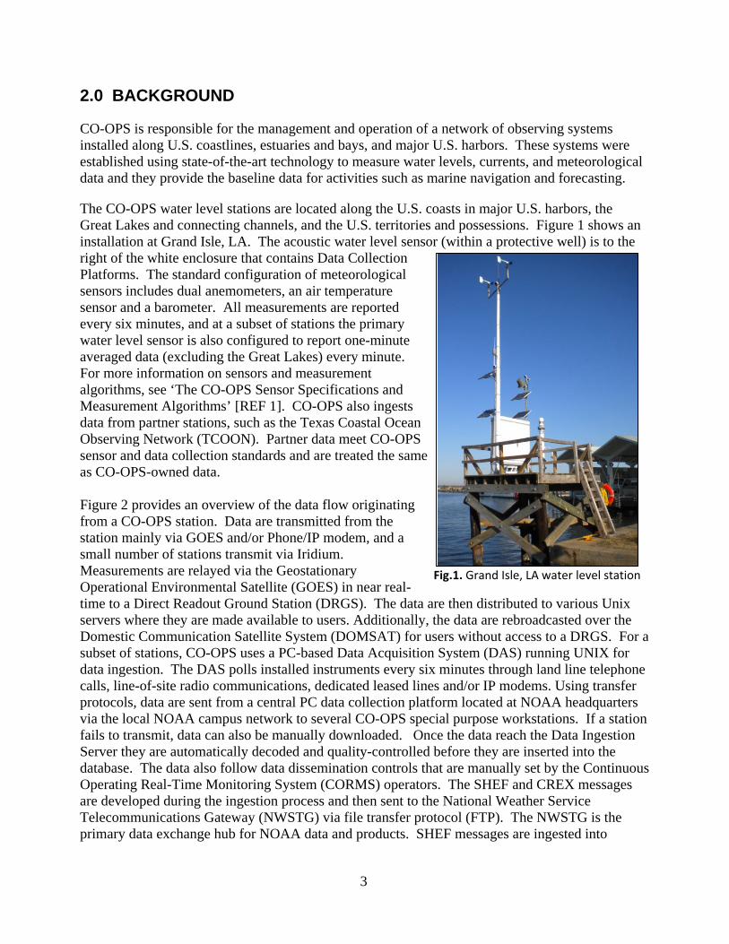
the Advanced Weather Interactive Processing System (AWIPS) Network Control Facility (NCF), which allows forecasters to view the data in AWIPS, a system heavily used by forecast centers. The NOAA/NWS National Centers for Environmental Prediction (NCEP) also ingests SHEF and CREX messages into their data tanks. CREX messages go through the Global Telecommunications Gateway (GTS) where they are accessible by the international user community. CO-OPS partner data are also included in the CREX and SHEF data products. A subset of these stations report via hourly GOES, however, therefore observations may not always populate the higher-frequency SHEF and CREX bulletins.
Each SHEF and CREX product is assigned a World Meteorological Organization (WMO) header that users require to identify the messages, and the stations data are grouped by geographic region under these headings. Both headers contain data type and geographical designators that allow users to identify the product at a glance. See Appendix 4 for a listing of the WMO and AWIPS headers.
Fig.2. Data flow from CO-OPS stations. Boxes indicate hardware or a system, and ovals indicate an action performed on the data. Blue refers to the data acquisition process, purple to the data ingestion process, red to database insertion, and green to distribution through the NWS Telecommunications Gateway.
4
In the Data section: • 3237339 and -06470331 are the latitude and longitude respectively, and are provided to
5 decimal places, as described in CREX/BUFR Table D [REF 3]. In this case, thecoordinates are 32.37339 N and 64.70331 W. Note that positive latitude/longitudevalues correspond to North and East, respectively and negative values correspond toSouth and West, respectively.
• BEPB6 is the National Weather Service Location Identifier (NWSLI) for Bermuda.Appendix 1 provides a list of the stations and associated NWSLI and NOS stationidentifiers.
• 2013 07 31 17 54 is the base time (7/31/2013 17:54 GMT) used to calculate themeasurement times for the water level values contained in the bulletin for the givenstation.
• 3038 is the sea surface temperature in Kelvin to the tenths (303.8 K).• 00 07 are two checks that indicate the overall quality of the data. The first set of digits is
the automated water level check and indicates the quality of the data (see Appendix 5 fora list of all automated checks). 00, per Appendix 5, indicates the data quality is good.The second set of digits is the manual water level check that is presently not used,therefore will always be set to 07, as defined in WMO Manual on Codes [REF 2].
• 00 06 are time increments applied to the base time to calculate the measurementtimestamp of the first and oldest water level value for the given station. 00 indicates thenumber of minutes that must be added to the first measurement, which is 0. Thefollowing 06 indicates the time increment between measurements, and is also added tothe base time to determine the timestamp of the first measurement.
In a six-minute water level bulletin, a data record contains six water level values and six associated residuals (except at Great Lakes stations). All data are reported in GMT, and are in millimeters. To determine the time of each 6-minute measurement start with the base time provided in the station header record, which in this case is 7/31/2013 17:54 GMT. The station header record indicates 00 minutes need to be added to 17:54 to calculate the measurement time for the first and oldest water level value. Then 06 minutes are added to the first value and then each succeeding measurement time. This means for BEPB6 the data listing is:
Measurement date/time (GMT)
Observed water level (above MLLW) Residual
7/31/2013 18:00 0.644 m -0.021 7/31/2013 18:06 0.653 m -0.023 7/31/2013 18:12 0.669 m -0.018 7/31/2013 18:18 0.680 m -0.018 7/31/2013 18:24 0.687m -0.020 7/31/2013 18:30 0.693 m -0.023
3.1.2 Meteorological The water level bulletins are supplemented by separate meteorological bulletins every thirty minutes. The meteorological bulletins contain one observation of surface winds, air temperature and barometric pressure (adjusted to mean sea level) for the most recent thirty-
6
minute transmission. Not all stations have all sensors, so it is possible to have meteorological bulletins that do not contain information for all of the given data types. Wind observations are at the height of the installed anemometer, which is typically 8-10 meters. Meteorological sensor elevations are available on the CO-OPS website, on the station information page for each station [REF 4]. The following is an example of a meteorological message:
WMO headers for meteorological CREX bulletins are the same as the six-minute water level bulletins. The RRA indicates that this bulletin is supplemental to the water level bulletin.
In the Data Description section the only difference from the 6-minute water level message is the sequence D06021, which indicates the message contains a station ID, date/time (GMT), data checks, air temperature (°C), barometric pressure adjusted to Mean Sea Level (mb), wind direction (degrees true), and wind speed (m/s) [REF 3].
In the Data section, the data provided are for the time stamp within the message. In this case, for BEPB6, the date of the measurements is 7/31/2013 18:00 GMT. The following values are listed in the order of the D06021 parameters. All data are provided to the nearest tenth, except wind direction. In this example, for BEPB6 at 7/31/2013 18:00 GMT:
Air temperature 285 28.5 °C Barometric pressure 10218 1021.8 mb Wind direction 315 315 degrees Wind speed 0020 2.0 m/s.
Not all stations contain every meteorological sensor, and any missing values will be presented as ////.
3.2 Observed One-minute Water Level Bulletins In addition to the routine six-minute data bulletins, CO-OPS also generates one-minute water level bulletins containing the most recent six samples of one-minute water level data. Tidal residuals are not produced for one-minute observations, therefore are not included. These bulletins are issued every three minutes. One-minute data are not collected at Great Lakes stations or stand-alone meteorological stations. See Appendix A for a list of stations that collect one-minute water levels. These bulletins are similar to the six-minute CREX bulletins but contain different sequences in the data description section, explained below:
In the message header: • SZAK35 KWBC is the WMO header for the Alaska Region CREX message, per
Appendix 4.• 311848: The bulletin was created on day 31 at 18:48 GMT.
In the Data Description section: • D01021: The message contains latitude and longitude.• D06019: The message contains a station ID, date/time, sea surface temperature,
quality control checks, and time increments [REF 3].• R01006 is a replicator and is applied to the following 1 element repeated 6 times.• B22038 refers to “tidal elevation with respect to local chart datum.” Since only
coastal stations measure 1-minute water levels, the chart datum is MLLW. Therefore,6 tidal elevation values are provided, as specified by the R01006.
In the Data section: • 55333183 and -13162619 are the latitude and longitude respectively, and are
provided to 5 decimal places. In this case, the coordinates are 55.33183 N and131.62619 W. Note that positive latitude/longitude values correspond to North andEast, respectively and negative values correspond to South and West, respectively.
• KECA2 is the NWSLI for Ketchikan, AK. Appendix 1 provides a list of the CO-OPS and partner stations and associated NWSLI and NOS stations.
• 2013 07 31 18 31 is the base time (07/31/2013 18:31 GMT) used to calculate themeasurement times for the water level values contained in the bulletin for the givenstation. All data are in GMT.
• 2868 is the sea surface temperature in Kelvin to the tenths (286.8 K).• 00 07 are two checks that indicate the overall quality of the data. The first set of
digits is the automated water level check and indicates the quality of the data (seeAppendix 5 for a list of all automated checks). 00, per Appendix 5, indicates the dataquality is good. The second set of digits is the manual water level check that ispresently not used, therefore will always be set to 07, as defined in WMO Manual onCodes [REF 2].
• 00 01 are time increments applied to the base time to calculate the measurement timeof the first and oldest water level value for the given station. 00 indicates the numberof minutes that must be added to the first measurement, which is 0. The following 01indicates the time increment between measurements, which is also applied to the firstmeasurement.
In a 1-minute water level bulletin, a data record contains six water level values reported in millimeters. To determine the time of each 1-minute measurement start with the time provided in the station header record, which in this case is 7/31/2013 18:31 GMT. The station header record indicates 00 minutes need to be added to 18:31 to calculate the measurement time for the first and oldest water level value. Then 01 minutes are applied to
8
the first value to determine each succeeding measurement time. This means for KECA2 the data listing is:
Measurement date/time (GMT) Observed water level
7/31/2013 18:32 2.666 m 7/31/2013 18:33 2.660 m 7/31/2013 18:34 2.654 m 7/31/2013 18:35 2.647 m 7/31/2013 18:36 2.641 m 7/31/2013 18:37 2.635 m
9
10
Data string: • DH2048 indicates that the observation time associated with the initial water level value
is 20:48 GMT, and is in the hour/minute format.• HMIRG are the parameter codes, which in this example indicates observed tide data
referenced to MLLW and received via GOES.o The HM designates water level data that have been corrected to MLLW (Mean
Lower Low Water). An HH in this position indicates the water level data arecorrected to Mean Sea Level (MSL) and an HG in this position refers to heightabove river stage.
o The I indicates the data are instantaneous.o All observed water level values will have either RG to indicate the value is received
via GOES, or RP to indicate the value is received via phone or IP. Oftentimes,stations are set up with redundant modes of communication, and the SHEF messageswill contain two lines of duplicate data values from each data source (e.g. HMIRGand HMIRP).
• The time interval, DIN06, indicates a time increment unit of minutes (N) and the intervalis 6. Therefore, the data are 6-minute observations.
The remaining values in the .E records associated with the given station are the water level data reported in feet. To determine the date and time of each measurement, start with the observation date and time, which in this case is 8/28/2013 20:48 GMT. This is the date and time for the first measurement. Since Data Interval designator indicates there is a 6-minute increment between each data measurement, 6 minutes are to be added to this time to determine the next measurement time, and so on. Therefore, the water level values for Eastport in this example are:
Measurement date/time (GMT)
Observed water level (MLLW)
8/28/2013 20:48 17.89 ft 8/28/2013 20:54 17.98 ft
Meteorological If meteorological data exists for a station, a meteorological SHEF bulletin is generated at the same time that the SHEF water level bulletin is generated, but under a different WMO header so that the bulletins are not overwritten. Currently, the meteorological parameters that can be included in the bulletin are air temperature, barometric pressure (sea level), wind speed, wind direction, wind gusts, water conductivity, and water temperature (sea surface). Not all stations have all sensors, so it is possible to have meteorological bulletins that do not contain information for all of the given data types. Should a new type of meteorological sensor be installed at a station, the data collected from that sensor for the given station would be added to the bulletin. Each meteorological bulletin includes the six-minute meteorological data value for each data type from the most recent transmission.
12
SXUS51 KWBC 161839 OSONT :SHEF ENCODED 6-MINUTE NOS MET DATA :NATIONAL WATER LEVEL OBSERVATION NETWORK (NWLON) :TA(AIR TEMP DEG F) SLP(SEA LEVEL PRESSURE INCHES) :UD(WIND DIRECTION WHOLE DEGREES) US (WIND SPEED MPH) :TW(WATER TEMP DEG F) UG(WIND GUSTS MPH) WC(CONDUCTIVITY uMHOS/CM) :-9999 (MISSING VALUES) :PROVIDED BY DOC/NOAA/NOS/CO-OPS, (301) 713-2540 :[email protected] .A NWPR1 20130916 Z DH1830/TAIRP -9999/UGIRP 6/PLIRP 30.01/UDIRP 324/USIRP 5/TWIRP 65/WCIRP -9999 .E CPTR1 20130916 Z DH1824/TAIRG/DIN06/ 61/ 61/-9999 .E CPTR1 20130916 Z DH1824/PLIRG/DIN06/30.03/30.02/-9999 .E CPTR1 20130916 Z DH1824/USIRG/DIN06/ 7/ 6/-9999 .E CPTR1 20130916 Z DH1824/UDIRG/DIN06/ 294/ 297/-9999 .E CPTR1 20130916 Z DH1824/UGIRG/DIN06/ 9/ 8/-9999 .E CPTR1 20130916 Z DH1824/TWIRG/DIN06/ 70/ 70
Message header: • SXUS51 KWBC is the WMO header for meteorological surface data in the North
Atlantic, per Appendix 4.• 161839: The bulletin was created on day 16 at 18:39 GMT.• OSONT is the AWIPS header for meteorological data in the North Atlantic Region, per
Appendix 4.Positional Fields:
• Both .A and .E formats are used within the bulletin. On the first data line in the aboveexample, the meteorological data for the given station is reported using the .A format(single station, multiple parameters).
• NWPR1 is the NWSLI for Newport, Rhode Island. Appendix 1 provides a list ofstations and associated NWSLI and NOS station identifiers.
• 20130916 (year/month/day) is the observation date that is to be associated with themeteorological value(s).
• Z specifies that the data are being reported in GMT. If the data are from a Great Lakesstation, this time is local standard time (CS for Central Standard or ES for EasternStandard).
Data string: • DH1830 indicates that the observation time is 18:30 GMT.• There are several parameter codes included in the meteorological bulletins, as seen in the
above example, e.g. TAIRG, UGIRG, etc. These differentiate the sensor reported.o Physical elements: TA for air temperature (degrees Fahrenheit), UG for wind gusts (miles per hour), PL for barometric pressure (sea level, inches), UD for wind direction (degrees),
13
US for wind speed (miles per hour), TW for water temperature (sea surface, degrees Fahrenheit), WC for water conductivity (uMHOS/CM).
o The I indicates the data are instantaneous.o All observed water level values will have either RG to indicate the value is
received via GOES, or RP to indicate the value is received via phone or IP.
Therefore, the data for Newport, RI in this example are:
Measurement date/time (GMT) Parameter Observed data
9/16/2013 18:30
Air temperature Not reported Wind gust 6 mph Barometric pressure 30.01 in Wind direction 324 deg Wind speed 5 mph Water temperature 65 F Conductivity Not reported
The meteorological data for the next station are reported using the .E format, meaning only one data type is provided as a time-series. The NWSLI is CPTR1 for Conimicut Light, RI. The observation date and time associated with the first meteorological value is 9/16/2013 18:24 GMT. The parameter codes are interpreted in the same manner as described previously for the .A-formatted records. TAIRG indicates the data are air temperature observations, transmitted via GOES. Since these are a time-series format, the first air temperature value at 18:24 GMT is 61 F, and the next value increments six minutes (18:30 GMT) and is 61 F.
4.2 Astronomical Tide Bulletins CO-OPS generates SHEF astronomical tide (also referred to as predicted tide) bulletins once per day at twenty minutes after midnight (GMT). Each bulletin contains ninety-six hourly water level predictions for each station within the given region, starting with 00:00 GMT of the day the report is run and ending with 23:00 GMT four days into the future. Since Great Lakes stations do not have tides, predictions are not calculated for these stations.
SOUS61 KWBC 160120 TIDNT :SHEF ENCODED 1 HOUR NOS WATER LEVEL PREDICTED DATA :NATIONAL WATER LEVEL OBSERVATION NETWORK (NWLON) :WATER LEVEL VALUES REFERENCED TO MLLW IN FEET (HMIFA) :AND MSL IN FEET (HHIFA) PROVIDED BY DOC/NOAA/NOS/CO-OPS :(301)713-2540, [email protected] .E PSBM1 20130916 Z DH0000/DC09160000/HMIFA/DIH1/ 19.52/ 18.07/ 14.88/ 10.79 .E1 6.35/ 2.28/ -0.17/ 0.06/ 2.75/ 6.88/ 11.61/ 15.96/ 18.53/ 18.51 .E2 16.31/ 12.80/ 8.64/ 4.37/ 1.04/ 0.04/ 1.78/ 5.50/ 10.24/ 15.15 .E3 18.85/ 20.05/ 18.61/ 15.33/ 11.00/ 6.20/ 1.78/ -0.80/ -0.51/ 2.35
Message header: • SOUS61 KWBC is the WMO header for data generated in the North Atlantic, per
Appendix 4.• 160120: The bulletin was created on day 16 at 01:20 GMT.• TIDNT is the AWIPS header for tide data in the North Atlantic Region, per Appendix 4.
Positional Fields: • Only the .E format is used (single station, single parameter time-series).• On the first .E line in the example, PSBM1 is the NWSLI for Eastport, ME. Appendix 1
provides a list of stations and associated NWSLI and NOS station identifiers.• 20130916 (year/month/day) is the date associated with the first astronomical tide value.• Z specifies that the data are being reported in GMT.
Data string: • DH0000 indicates that the time of the first astronomical tide value is 00:00 GMT.• DC09160000 (month/day/time) is the creation date of 09/16 00:00 GMT. Although this
information is already included within the bulletin, and thus may seem redundant, thecreation date is included to avoid generating a ‘nonfatal SHEF error’ in decoders.Therefore, CO-OPS has chosen to include this DC field with the samemonth/day/hour/minute information contained in 20130916 and DH0000.
• HMIFA is the parameter code for the predicted tide data. (Note: In previous versions,HMIFZ was used but has been changed to FA as of Dec. 2012.).o HM: Water level data that have been corrected to MLLW. An HH in this position
would designate water level data that have been corrected to MSL.o I indicates the data are instantaneous.o FA indicates adjusted forecast model data, per the NWS SHEF Code Manual [REF
5]. • The final set of characters in the header, DIH1, indicates a time increment of 1
hour between each data measurement.
The remaining values are astronomical tides above MLLW, reported in feet. The date and time for the first measurement is 09/16/2013 00:00 GMT, and the Data Interval designator indicates 1 hour is to be added to this time to determine the next value timestamp, and so on. Therefore, the tide predictions for Eastport in this example are:
Date/time (GMT) Astronomical tide (MLLW)
9/16/2013 00:00 19.52 ft 9/16/2013 01:00 18.07 ft
15
9/16/2013 02:00 14.88 ft ...
9/19/2013 21:00 -1.40 ft 9/19/2013 22:00 -1.61 ft 9/19/2013 23:00 1.17 ft
4.3 OFS Water Level Guidance Bulletins In December 2012, CO-OPS released new SHEF bulletins containing Operational Forecast System (OFS) water level model guidance from the OFS models. Ten OFS models (Chesapeake Bay, Delaware Bay, Tampa Bay, Northern Gulf of Mexico, Columbia River Estuary, and the five Great Lakes models) produce 48-hour model guidance of time series data updated every 6 hours, and two models (New York/New Jersey and St. Johns River) provide 24-hour model guidance updated every 6 hours. Modeled water levels are total water levels (astronomical tide plus surge). CO-OPS models are not designed as a storm surge model, although meteorological conditions are taken into account. Model guidance is only provided at the location of active and historical water level station locations (Appendix 1). Historical stations are stations that have been physically removed and are no longer used. Model grid points outside these locations are not included. Thus, the OFS Water Level SHEF bulletins contain the full 48-hour or 24-hour model guidance of 30-minute data, and are issued every 6 hours to remain consistent with the OFS output. More information on the OFS models can be found on the CO-OPS website [REF 4].
Message header: • SOUS41 KWBC is the WMO header for surface data in the North Atlantic, per
Appendix 4.• 191630: The bulletin was created on day 19 at 16:30 GMT.• TIDCB is the AWIPS header, and pertains to the Chesapeake Bay OFS, per Appendix 4.
16
Positional Fields: • Only the.E format is used (single station, single parameter time-series).• On the first .E line in the above example, SWPV2 is the NWSLI for Sewells Point, VA.
Appendix 1 provides a list of active and historical stations that may be used in the OFSbulletins.
• 20121119 (year/month/day) is the date that is to be associated with the first modelguidance value.
• Z specifies that the data are being reported in GMT.Data string:
• DH1200 indicates that the time of the first value is 12:00 GMT.• DC11191200 is the creation date of 11/19 at 12:00 GMT, which is the date and time
that the model guidance is valid. In this case, the Chesapeake Bay OFS model was runon 11/19 at 12:00 GMT.
• HMIFU is the parameter code for the model guidance data.o HM designates the generation of forecast water level data that has been corrected
to MLLW (Mean Lower Low Water). An HH in this position would designatewater level data that have been corrected to MSL (Mean Sea Level) and an HG inthis position refers to height above river stage.
o The I indicates the data are instantaneous.o FU indicates unadjusted forecast model data, per the NWS SHEF Code Manual
[REF 5].• The final set of characters in the header, DIN30, indicates a time increment of thirty
minutes between each data measurement.
The remaining values are the water level guidance reported in feet. The date and time of the first value is 11/19/2012 12:00. Thirty minutes needs to be added to this time to determine the timestamp of the next value, and so on. Therefore, the model guidance for Sewells Point in this example is:
Date/time (GMT) Water Level Guidance (MLLW)
11/19/2012 12:00 1.537 ft 11/19/2012 12:30 1.644 ft 11/19/2012 13:00 1.809 ft
.
.
.11/21/2012 10:30 2.548 ft 11/21/2012 11:00 2.246 ft 11/21/2012 11:30 1.987 ft
17
18
5.0 INFORMATION
5.1 Station Status CO-OPS maintains an interface on its Web Services home page that provides a convenient view of the sensor dissemination status for each CO-OPS and CO-OPS partner station. This sensor status display is located at http://opendap.co-ops.nos.noaa.gov/stations/index.jsp. If dissemination of a sensor is stopped by the CORMS quality control operators, then the data will not be included in the SHEF and CREX bulletins. Dissemination will be turned off if stations or sensors are not transmitting data, are malfunctioning, are undergoing maintenance, or an event has temporarily or permanently impacted the operation of the station. If an entire station is not operating, the station will not be listed in the CREX and SHEF bulletins. Stations are listed by a seven-digit NOS identifier. To determine the associated NWS Location Identifier (NWSLI, or sometimes referred to as a SHEF ID) associated with the station, see Appendix 1, or the Web Services XML file of active water level/meteorological stations located here: http://opendap.co-ops.nos.noaa.gov/axis/webservices/activestations/response.jsp?v=2&format=xml&Submit=Submit
5.2 Product Changes/Updates Any changes to CREX or SHEF products will be communicated through a Service Change Notice (SCN), per NWS Directive 10-1805 [REF 7], which will be posted on the NWS Office of Climate, Water and Weather Services website: http://www.nws.noaa.gov/om/notif.htm. The SCN will provide a thirty-day lead time for users to adjust their decoders or applications. Users who subscribe to these notices will automatically receive the updates, and they are also ingested into AWIPS. In addition to the SCN, CREX changes will be posted to the GTS thirty days ahead of time. All notifications will include the product WMO header, and if applicable, AWIPS header, as well as an implementation date.
5.3 Reporting Problems It is expected that from time to time there may be questions regarding the operation of these various products or suggestions for improvement. Users should contact CO-OPS User Services ([email protected], 301-713-2890) for any questions related to the data or products.
1. CO-OPS Sensor Specifications and Measurement Algorithms, July 2013http://tidesandcurrents.noaa.gov/publications/CO-OPS_Measure_Spec_07_July_2013.pdf
2. World Meteorological Organization Manual on Codes (WMO-No. 306)http://www.wmo.int/pages/prog/www/WMOCodes.html
3. World Meteorological Organization BUFR/CREX Tableshttp://www.wmo.int/pages/prog/www/WMOCodes/WMO306_vI2/PrevVERSIONS/20121107/20121107.html
6. World Meteorological Organization Manual on the Global Telecommunication System(WMO – No. 386)http://www.wmo.int/pages/prog/www/ois/Operational_Information/Publications/WMO_386/WMO_386_Vol_I_2009_en.pdf
7. National Weather Service Directive 10-1805 National Service Change and TechnicalImplementation Noticeshttp://www.nws.noaa.gov/directives/sym/pd01018005curr.pdf
8. National Weather Service Directive 10-101 Change Management Processhttp://www.nws.noaa.gov/directives/sym/pd01001001curr.pdf
Below is a list of the stations included in the CREX and SHEF messages. Both the NOS and NWS identifiers are given, along with the common station name, and its latitude and longitude. NOS station identifiers have been assigned by NOS, and are always 7 digits in length. The NWS Location Identifiers are assigned by NWS and are 5 alphanumeric characters in length. Latitude and Longitude (decimal degrees) are the historical positions identified when the station was first established, and were used to determine the NOS ID. However, some stations that were destroyed and rebuilt, or relocated, might have different positions than what is listed below. Please contact [email protected] with any questions.
To see any changes made to this listing between revision releases of this document, connect to CO-OPS Web Services Data Inventory page and select an NOS ID: http://opendap.co-ops.nos.noaa.gov/axis/webservices/datainventory/index.jsp
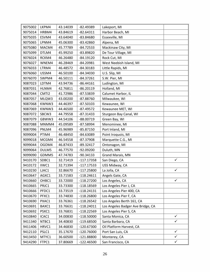
Active stations:
NOS ID NWSLI LAT LON LOCATION Has 1-min WL Data
1611400 NWWH1 21.95440 -159.35610 Nawiliwili, HI 1612340 OOUH1 21.30669 -157.86700 Honolulu, HI 1612480 MOKH1 21.43303 -157.78989 Mokuoloe, HI 1615680 KLIH1 20.89500 -156.47669 Kahului, HI 1617433 KWHH1 20.03660 -155.82940 Kawaihae, HI 1617760 ILOH1 19.73031 -155.05589 Hilo, HI 1619910 SNDP5 28.21170 -177.36000 Sand Island, Midway Islands 1630000 APRP7 13.44310 144.65560 Apra Harbor, Guam 1631428 PGBP7 13.42830 144.79890 Pago Bay, Guam 1770000 NSTP6 -14.27661 -170.68931 Pago Pago, American Samoa 1820000 KWJP8 8.73200 167.73439 Kwajalein, Marshall Islands 1890000 WAKP8 19.29067 166.61758 Wake Island, Pacific Ocean 2695540 BEPB6 32.37331 -64.70331 Bermuda Esso Pier 8311030 OBGN6 44.70286 -75.49444 Ogdensburg, NY 8311062 ALXN6 44.33111 -75.93453 Alexandria Bay, NY 8410140 PSBM1 44.90331 -66.98500 Eastport, ME 8411060 CFWM1 44.65703 -67.20467 Cutler Farris Wharf, ME 8413320 ATGM1 44.39219 -68.20428 Bar Harbor, ME 8418150 CASM1 43.65670 -70.24670 Portland, ME 8419317 WELM1 43.32000 -70.56331 Wells, ME 8423898 FTPN3 43.07170 -70.71170 Fort Point, NH 8443970 BHBM3 42.35480 -71.05340 Boston, MA 8447386 FRVM3 41.70430 -71.16410 Fall River, MA 8447387 BLTM3 41.70500 -71.17330 Borden Flats Light, MA
8447930 BZBM3 41.52330 -70.67170 Woods Hole, MA 8449130 NTKM3 41.28500 -70.09670 Nantucket Island, RI 8452660 NWPR1 41.50500 -71.32670 Newport, RI 8452944 CPTR1 41.71670 -71.34330 Conimicut Light, RI 8452951 PTCR1 41.63717 -71.33928 Potter Cove, RI 8454000 FOXR1 41.80710 -71.40120 Providence, RI 8454049 QPTR1 41.58680 -71.41100 Quonset Point, RI 8461490 NLNC3 41.36139 -72.08997 New London, CT 8465705 NWHC3 41.28330 -72.90830 New Haven, CT 8467150 BRHC3 41.17330 -73.18170 Bridgeport, CT 8510560 MTKN6 41.04830 -71.96000 Montauk, NY 8516945 KPTN6 40.81030 -73.76490 Kings Point, NY 8518750 BATN6 40.70060 -74.01420 The Battery, NY 8519483 BGNN4 40.63670 -74.14170 Bergen Point West Reach, NY 8530973 ROBN4 40.65670 -74.06500 Robbins Reef, NJ 8531680 SDHN4 40.46690 -74.00940 Sandy Hook, NJ 8534720 ACYN4 39.35500 -74.41830 Atlantic City, NJ 8536110 CMAN4 38.96833 -74.96000 Cape May, NJ 8537121 SJSN4 39.30500 -75.37500 Ship John Shoal, NJ 8538886 TPBN4 40.01194 -75.04300 Tacony-Palmyra Bridge, NJ 8539094 BDRN4 40.08170 -74.86970 Burlington, NJ 8540433 MRCP1 39.81170 -75.41000 Marcus Hook, PA 8545240 PHBP1 39.93333 -75.14167 Philadelphia, PA 8548989 NBLP1 40.13670 -74.75170 Newbold, PA 8551762 DELD1 39.58170 -75.58830 Delaware City, DE 8551910 RDYD1 39.55831 -75.57331 Reedy Point, DE 8557380 LWSD1 38.78169 -75.12000 Lewes, DE 8570283 OCIM2 38.32833 -75.09167 Ocean City Inlet, MD 8571421 BISM2 38.22000 -76.03830 Bishops Head, MD 8571892 CAMM2 38.57330 -76.06830 Cambridge, MD 8573364 TCBM2 39.21333 -76.24500 Tolchester Beach, MD 8573927 CHCM2 39.52670 -75.81000 Chesapeake City, MD 8574680 BLTM2 39.26667 -76.57833 Baltimore, MD 8574728 FSKM2 39.22000 -76.52830 Francis Scott Key Bridge, MD 8575512 APAM2 38.98328 -76.48156 Annapolis, MD 8577018 COVM2 38.40436 -76.38550 Cove Point LNG Pier, MD 8577330 SLIM2 38.31667 -76.45167 Solomons Island, MD 8578240 PPTM2 38.13330 -76.53330 Piney Point, MD 8594900 WASD2 38.87333 -77.02167 Washington, DC 8631044 WAHV2 37.60778 -75.68583 Wachapreague, VA 8632200 KPTV2 37.16519 -75.98844 Kiptopeke, VA 8632837 RPLV2 37.53830 -76.01500 Rappahannock Light, VA 8635750 LWTV2 37.99611 -76.46444 Lewisetta, VA
22
8636580 WNDV2 37.61620 -76.29000 Windmill Point, VA 8637611 YKRV2 37.25000 -76.33330 York River East Rear Range Light, VA 8637689 YKTV2 37.22667 -76.47833 Yorktown USCG Training Center, VA 8638511 DOMV2 36.96232 -76.42421 Dominion Terminal Associates, VA 8638595 CRYV2 36.88830 -76.33830 South Craney Island, VA 8638610 SWPV2 36.94667 -76.33000 Sewells Point, VA 8638614 WDSV2 36.98170 -76.32170 Willoughby Degaussing Station, VA 8638863 CBBV2 36.96667 -76.11333 Chesapeake Bay Bridge Tunnel, VA 8638999 CHYV2 36.93000 -76.00670 Cape Henry, VA 8639348 MNPV2 36.77830 -76.30170 Money Point, VA 8651370 DUKN7 36.18331 -75.74669 Duck, NC 8652587 ORIN7 35.79500 -75.54830 Oregon Inlet Marina, NC 8654467 HCGN7 35.20864 -75.70417 USCG Station Hatteras, NC 8656483 BFTN7 34.72000 -76.67000 Beaufort, NC 8658120 WLON7 34.22670 -77.95330 Wilmington, NC 8658163 JMPN7 34.21330 -77.78670 Wrightsville Beach, NC 8661070 MROS1 33.65500 -78.91830 Springmaid Pier, SC 8662245 NITS1 33.35170 -79.18670 Oyster Landing, SC 8665530 CHTS1 32.78170 -79.92500 Charleston, SC 8670870 FPKG1 32.03330 -80.90170 Fort Pulaski, GA 8720030 FRDF1 30.67170 -81.46500 Fernandina Beach, FL 8720218 MYPF1 30.39670 -81.43000 Mayport (Bar Pilots Dock), FL 8720357 BKBF1 30.19170 -81.69170 I-295 Bridge, St Johns River, FL 8721604 TRDF1 28.41580 -80.59310 Trident Pier, FL 8722670 LKWF1 26.61170 -80.03330 Lake Worth Pier, FL 8723214 VAKF1 25.73140 -80.16180 Virginia Key, FL 8723970 VCAF1 24.71170 -81.10500 Vaca Key, FL 8724580 KYWF1 24.55570 -81.80790 Key West, FL 8725110 NPSF1 26.13170 -81.80750 Naples, FL 8725520 FMRF1 26.64770 -81.87120 Fort Myers, FL 8726384 PMAF1 27.63870 -82.56210 Port Manatee, FL 8726413 CCUF1 27.66330 -82.61830 C-Cut, FL 8726520 SAPF1 27.76060 -82.62690 St. Petersburg, FL 8726607 OPTF1 27.85778 -82.55269 Old Port Tampa, FL 8726667 MCYF1 27.91333 -82.42500 Mckay Bay Entrance, FL 8726669 ERTF1 27.91720 -82.44380 Berth 223, FL 8726673 SBLF1 27.92330 -82.44500 Seabulk, FL 8726679 TSHF1 27.92889 -82.42575 East Bay Causeway, FL 8726694 TPAF1 27.93330 -82.43330 TPA Cruise Terminal 2, FL 8726724 CWBF1 27.97830 -82.83170 Clearwater Beach, FL 8727520 CKYF1 29.13500 -83.03170 Cedar Key, FL 8728690 APCF1 29.72670 -84.98170 Apalachicola, FL 8729108 PACF1 30.15228 -85.66694 Panama City, FL
23
8729210 PCBF1 30.21330 -85.87830 Panama City Beach, FL 8729840 PCLF1 30.40440 -87.21120 Pensacola, FL 8732828 WBYA1 30.41670 -87.82500 Weeks Bay, AL 8734673 FMOA1 30.22830 -88.02500 Fort Morgan, AL 8735180 DILA1 30.25000 -88.07500 Dauphin Island, AL 8735391 BYSA1 30.56517 -88.08800 Dog River Bridge, AL 8735523 EFRA1 30.44369 -88.11392 East Fowl River Bridge, AL 8736163 MBPA1 30.52711 -88.08656 Middle Bay Port, AL 8736897 MCGA1 30.64830 -88.05830 Coast Guard Sector Mobile, AL 8737005 PTOA1 30.67114 -88.03106 Pinto Island, AL 8737048 OBLA1 30.70830 -88.04330 Mobile State Docks, AL 8737138 CIKA1 30.78189 -88.07361 Chickasaw Creek, AL 8738043 WFRA1 30.37664 -88.15856 West Fowl River Bridge, AL 8739803 BLBA1 30.40567 -88.24769 Bayou La Batre Bridge, AL 8741003 PTBM6 30.21330 -88.50000 Petit Bois Island, MS 8741041 ULAM6 30.34770 -88.50540 Dock E, MS 8741094 RARM6 30.34330 -88.51170 Range A Rear, MS 8741501 DKCM6 30.35500 -88.56670 Dock C, MS 8741533 PNLM6 30.36790 -88.56300 Pascagoula NOAA Lab, MS 8747437 WYCM6 30.32639 -89.32578 Bay Waveland Yacht Club, MS 8760721 PILL1 29.17830 -89.25830 Pilottown, LA 8760922 PSTL1 28.93220 -89.40750 Pilots Station East, SW Pass, LA 8761305 SHBL1 29.86811 -89.67325 Shell Beach, LA 8761724 GISL1 29.26333 -89.95667 Grand Isle, LA 8761927 NWCL1 30.02717 -90.11342 New Canal Station, LA 8761955 CARL1 29.93289 -90.13547 Carrollton, LA 8762075 PTFL1 29.11425 -90.19925 Port Fourchon, LA 8762482 BYGL1 29.78856 -90.42019 West Bank, Bayou Gauche, LA 8764044 TESL1 29.66750 -91.23761 Berwick, LA 8764227 AMRL1 29.44958 -91.33811 LAWMA, Amerada Pass, LA 8766072 FRWL1 29.55500 -92.30500 Freshwater Canal Locks, LA 8767816 LCLL1 30.22364 -93.22167 Lake Charles, LA 8767961 BKTL1 30.19031 -93.30069 Bulk Terminal, LA 8768094 CAPL1 29.76817 -93.34289 Calcasieu Pass, LA 8770475 PORT2 29.86670 -93.93000 Port Arthur, TX 8770520 RBBT2 29.98000 -93.88170 Rainbow Bridge, TX 8770570 SBPT2 29.72840 -93.87010 Sabine Pass North, TX 8770613 MGPT2 29.68170 -94.98500 Morgans Point, TX 8770777 NCHT2 29.72628 -95.26581 Manchester, TX 8770822 TXPT2 29.67806 -93.83694 Texas Point, Sabine Pass, TX 8770971 RLOT2 29.51500 -94.51330 Rollover Pass, TX 8771013 EPTT2 29.48000 -94.91830 Eagle Point, TX 8771341 GNJT2 29.35733 -94.72483 Galveston Bay Entrance, North Jetty, TX
24
8771450 GTOT2 29.31000 -94.79330 Galveston Pier 21, TX 8772447 FCGT2 28.94331 -95.30250 USCG Freeport, TX 8773037 SDRT2 28.40830 -96.71170 Seadrift, TX 8773259 VCAT2 28.64000 -96.59500 Port Lavaca, TX 8773701 PCNT2 28.45170 -96.38830 Port O'Connor, TX 8774513 CPNT2 28.11830 -97.02170 Copano Bay, TX 8774770 RCPT2 28.02170 -97.04670 Rockport, TX 8775237 RTAT2 27.83830 -97.07330 Port Aransas, TX 8775283 NGLT2 27.82170 -97.20330 Port Ingleside, TX 8775296 TAQT2 27.81170 -97.39000 USS Lexington, TX 8775792 PACT2 27.63330 -97.23670 Packery Channel, TX 8775870 MQTT2 27.58000 -97.21670 Bob Hall Pier, TX 8776139 IRDT2 27.48000 -97.32170 S. Bird Island, TX 8776604 BABT2 27.29500 -97.40500 Baffin Bay, TX 8777812 RSJT2 26.82500 -97.49170 Rincon Del San Jose, TX 8779748 PCGT2 26.07670 -97.17670 South Padre Island, TX 8779770 PTIT2 26.06000 -97.21500 Port Isabel, TX 9014070 AGCM4 42.62100 -82.52690 Algonac, MI 9014080 SCRM4 42.81240 -82.48581 St Clair State Police, MI 9014087 PHXM4 42.94530 -82.44350 Dry Dock, MI 9014090 MBRM4 42.97380 -82.42040 Mouth of the Black River, MI 9014096 DUPM4 43.00250 -82.42240 Dunn Paper, MI 9014098 FTGM4 43.00690 -82.42250 Fort Gratiot, MI 9034052 SCSM4 42.47322 -82.87925 St Clair Shores, MI 9044020 GRTM4 42.09090 -83.18600 Gibraltar, MI 9044030 WDTM4 42.20240 -83.14750 Wyandotte, MI 9044036 FWNM4 42.29894 -83.09258 Fort Wayne, MI 9044049 WMPM4 42.35778 -82.92994 Windmill Point, MI 9052000 CAVN6 44.13019 -76.33197 Cape Vincent, NY 9052030 OSGN6 43.46417 -76.51183 Oswego, NY 9052058 RCRN6 43.26903 -77.62575 Rochester, NY 9052076 OCTN6 43.33839 -78.72733 Olcott, NY 9063007 NGAN6 43.09992 -79.05992 Ashland Ave., NY 9063009 AMFN6 43.08106 -79.06136 American Falls, NY 9063012 NIAN6 43.07692 -79.01389 Niagara Intake, NY 9063020 BUFN6 42.87744 -78.89047 Buffalo, NY 9063028 PSTN6 42.69131 -79.04733 Sturgeon Point, NY 9063038 EREP1 42.15400 -80.09250 Erie, PA 9063053 FAIO1 41.75975 -81.28106 Fairport, OH 9063063 CNDO1 41.54086 -81.63547 Cleveland, OH 9063079 MRHO1 41.54364 -82.73139 Marblehead, OH 9063085 THRO1 41.69356 -83.47228 Toledo, OH 9063090 FPPM4 41.96010 -83.25690 Fermi Power Plant, OH
25
9075002 LKPM4 43.14039 -82.49389 Lakeport, MI 9075014 HRBM4 43.84619 -82.64311 Harbor Beach, MI 9075035 ESVM4 43.64040 -83.84680 Essexville, MI 9075065 LPNM4 45.06300 -83.42860 Alpena, MI 9075080 MACM4 45.77789 -84.72533 Mackinaw City, MI 9075099 DTLM4 45.99250 -83.89820 De Tour Village, MI 9076024 RCKM4 46.26480 -84.19120 Rock Cut, MI 9076027 WNEM4 46.28469 -84.20981 West Neebish Island, MI 9076033 LTRM4 46.48572 -84.30183 Little Rapids, MI 9076060 USSM4 46.50100 -84.34030 U.S. Slip, MI 9076070 SWPM4 46.50111 -84.37261 S.W. Pier, MI 9087023 LDTM4 43.94736 -86.44161 Ludington, MI 9087031 HLNM4 42.76811 -86.20119 Holland, MI 9087044 CMTI2 41.72986 -87.53839 Calumet Harbor, IL 9087057 MLQW3 43.00200 -87.88760 Milwaukee, WI 9087068 KWNW3 44.46397 -87.50103 Kewaunee, WI 9087069 KWNW3 44.46500 -87.49572 Kewaunee MET, WI 9087072 SBCW3 44.79558 -87.31433 Sturgeon Bay Canal, WI 9087079 GBWW3 44.54106 -88.00719 Green Bay, WI 9087088 MNMM4 45.09589 -87.58994 Menominee, MI 9087096 PNLM4 45.96989 -85.87150 Port Inland, MI 9099004 PTIM4 46.48450 -84.63089 Point Iroquois, MI 9099018 MCGM4 46.54558 -87.37908 Marquette C.G., MI 9099044 OGOM4 46.87433 -89.32417 Ontonagon, MI 9099064 DULM5 46.77570 -92.09200 Duluth, MN 9099090 GDMM5 47.74783 -90.34133 Grand Marais, MN 9410170 SDBC1 32.71419 -117.17358 San Diego, CA 9410172 IIWC1 32.71394 -117.17533 USS Midway, CA 9410230 LJAC1 32.86670 -117.25800 La Jolla, CA 9410647 AGXC1 33.71583 -118.24611 Angels Gate, CA 9410660 OHBC1 33.72000 -118.27200 Los Angeles, CA 9410665 PRJC1 33.73300 -118.18569 Los Angeles Pier J, CA 9410666 PFDC1 33.73519 -118.24131 Los Angeles Pier 400, CA 9410670 PFXC1 33.74830 -118.26800 Los Angeles Pier F, CA 9410690 PXAC1 33.76361 -118.26542 Los Angeles Berth 161, CA 9410691 BAXC1 33.76631 -118.24011 Los Angeles Badger Ave Bridge, CA 9410692 PSXC1 33.76831 -118.22569 Los Angeles Pier S, CA 9410840 ICAC1 34.00830 -118.50000 Santa Monica, CA 9411340 NTBC1 34.40830 -119.68500 Santa Barbara, CA 9411406 HRVC1 34.46830 -120.67300 Oil Platform Harvest, CA 9412110 PSLC1 35.17670 -120.76000 Port San Luis, CA 9413450 MTYC1 36.60500 -121.88800 Monterey, CA 9414290 FTPC1 37.80669 -122.46500 San Francisco, CA
26
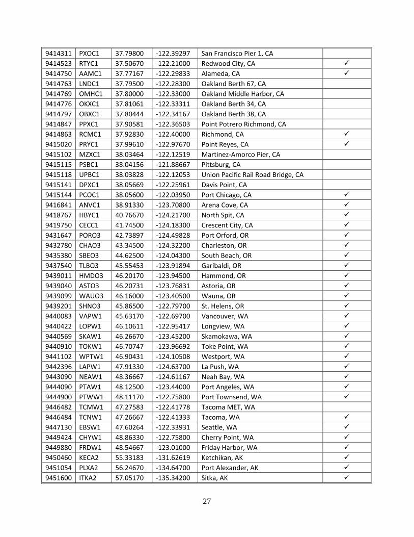
9414311 PXOC1 37.79800 -122.39297 San Francisco Pier 1, CA 9414523 RTYC1 37.50670 -122.21000 Redwood City, CA 9414750 AAMC1 37.77167 -122.29833 Alameda, CA 9414763 LNDC1 37.79500 -122.28300 Oakland Berth 67, CA 9414769 OMHC1 37.80000 -122.33000 Oakland Middle Harbor, CA 9414776 OKXC1 37.81061 -122.33311 Oakland Berth 34, CA 9414797 OBXC1 37.80444 -122.34167 Oakland Berth 38, CA 9414847 PPXC1 37.90581 -122.36503 Point Potrero Richmond, CA 9414863 RCMC1 37.92830 -122.40000 Richmond, CA 9415020 PRYC1 37.99610 -122.97670 Point Reyes, CA 9415102 MZXC1 38.03464 -122.12519 Martinez-Amorco Pier, CA 9415115 PSBC1 38.04156 -121.88667 Pittsburg, CA 9415118 UPBC1 38.03828 -122.12053 Union Pacific Rail Road Bridge, CA 9415141 DPXC1 38.05669 -122.25961 Davis Point, CA 9415144 PCOC1 38.05600 -122.03950 Port Chicago, CA 9416841 ANVC1 38.91330 -123.70800 Arena Cove, CA 9418767 HBYC1 40.76670 -124.21700 North Spit, CA 9419750 CECC1 41.74500 -124.18300 Crescent City, CA 9431647 PORO3 42.73897 -124.49828 Port Orford, OR 9432780 CHAO3 43.34500 -124.32200 Charleston, OR 9435380 SBEO3 44.62500 -124.04300 South Beach, OR 9437540 TLBO3 45.55453 -123.91894 Garibaldi, OR 9439011 HMDO3 46.20170 -123.94500 Hammond, OR 9439040 ASTO3 46.20731 -123.76831 Astoria, OR 9439099 WAUO3 46.16000 -123.40500 Wauna, OR 9439201 SHNO3 45.86500 -122.79700 St. Helens, OR 9440083 VAPW1 45.63170 -122.69700 Vancouver, WA 9440422 LOPW1 46.10611 -122.95417 Longview, WA 9440569 SKAW1 46.26670 -123.45200 Skamokawa, WA 9440910 TOKW1 46.70747 -123.96692 Toke Point, WA 9441102 WPTW1 46.90431 -124.10508 Westport, WA 9442396 LAPW1 47.91330 -124.63700 La Push, WA 9443090 NEAW1 48.36667 -124.61167 Neah Bay, WA 9444090 PTAW1 48.12500 -123.44000 Port Angeles, WA 9444900 PTWW1 48.11170 -122.75800 Port Townsend, WA 9446482 TCMW1 47.27583 -122.41778 Tacoma MET, WA 9446484 TCNW1 47.26667 -122.41333 Tacoma, WA 9447130 EBSW1 47.60264 -122.33931 Seattle, WA 9449424 CHYW1 48.86330 -122.75800 Cherry Point, WA 9449880 FRDW1 48.54667 -123.01000 Friday Harbor, WA 9450460 KECA2 55.33183 -131.62619 Ketchikan, AK 9451054 PLXA2 56.24670 -134.64700 Port Alexander, AK 9451600 ITKA2 57.05170 -135.34200 Sitka, AK
27
9452210 JNEA2 58.29830 -134.41200 Juneau, AK 9452400 SKTA2 59.45000 -135.32700 Skagway, AK 9452634 ELFA2 58.19472 -136.34694 Elfin Cove, AK 9453220 YATA2 59.54850 -139.73340 Yakutat, AK 9454050 CRVA2 60.55830 -145.75300 Cordova, AK 9454240 VDZA2 61.12500 -146.36200 Valdez, AK 9455090 SWLA2 60.12000 -149.42667 Seward, AK 9455500 OVIA2 59.44053 -151.71994 Seldovia, AK 9455760 NKTA2 60.68330 -151.39800 Nikiski, AK 9455920 ANTA2 61.23831 -149.89000 Anchorage, AK 9457292 KDAA2 57.73170 -152.51200 Kodiak Island, AK 9457804 ALIA2 56.89830 -154.24700 Alitak, AK 9459450 SNDA2 55.33669 -160.50200 Sand Point, AK 9459881 KGCA2 55.06170 -162.32700 King Cove, AK 9461380 ADKA2 51.86330 -176.63200 Adak Island, AK 9461710 ATKA2 52.23170 -174.17300 Atka, AK 9462450 OLSA2 52.94061 -168.87131 Nikolski, AK 9462620 UNLA2 53.88000 -166.53700 Unalaska, AK 9463502 PMOA2 55.99000 -160.56200 Port Moller, AK 9464212 VCVA2 57.12531 -170.28517 Village Cove, AK 9468756 NMTA2 64.50000 -165.43000 Nome, AK 9491094 RDDA2 67.57670 -164.06500 Red Dog Dock, AK 9497645 PRDA2 70.40000 -148.52700 Prudhoe Bay, AK 9751364 CHSV3 17.75000 -64.70500 Christiansted Harbor, VI 9751381 LAMV3 18.31825 -64.72422 Lameshur Bay, VI 9751401 LTBV3 17.69472 -64.75381 Lime Tree Bay, VI 9751639 CHAV3 18.33583 -64.92000 Charlotte Amalie, VI 9752619 VQSP4 18.15253 -65.44381 Isabel Segunda, PR 9752695 ESPP4 18.09386 -65.47136 Esperanza, PR 9753216 FRDP4 18.33522 -65.63111 Fajardo, PR 9754228 YABP4 18.05508 -65.83300 Yabucoa Harbor, PR 9755371 SJNP4 18.45894 -66.11642 San Juan, PR 9757809 AROP4 18.48053 -66.70236 Arecibo, PR 9758053 PLSP4 17.97253 -66.76178 Penuelas, PR 9759110 MGIP4 17.97008 -67.04642 Magueyes Island, PR 9759394 MGZP4 18.22000 -67.16000 Mayaguez, PR 9759938 MISP4 18.08992 -67.93850 Mona Island, PR 9761115 BARA9 17.59069 -61.82056 Barbuda
28
Historical stations used only in OFS bulletins:
NOS ID NWSLI LAT LON LOCATION 8517276 CLGN6 40.78331 73.85669 College Point, NY 8518668 HHKN6 40.77669 73.94169 Horns Hook, NY 8518905 RIVN6 40.90331 73.91669 Riverdale, NY 8519024 FTWN6 40.60669 74.05500 Fort Wadsworth, NY 8530528 CARN4 40.80669 74.06000 Carlstadt, NJ 8530882 LIZN4 40.67331 74.14000 Port Elizabeth, NJ 8530985 CHKN4 40.65500 74.08500 Constable Hook, NJ 8531232 SMBN4 40.49169 74.28169 South Amboy, NJ 8720219 DMSF1 30.38669 81.55831 Dames Point, FL 8720226 MSBF1 30.32000 81.65831 Main Street Bridge, FL 8720242 LNBF1 30.36000 81.62000 Longbranch, FL 8720503 GCVF1 29.97831 81.62831 Red Bay Point, FL 8720625 RCYF1 29.80169 81.54831 Racy Point, FL 8720767 BUFF1 29.59500 81.68169 Buffalo Bluff, FL 8720774 PLQF1 29.64331 81.63169 Palatka, FL 8725858 VENF1 27.07169 82.45331 Venice Pier, FL 8726217 CTZF1 27.46669 82.68831 Cortez, FL 8726243 AMOF1 27.49669 82.71331 Anna Maria Outside, FL 8726347 EGMF1 27.60169 82.76000 Egmont Key, FL 8726364 MUQF1 27.61500 82.72669 Mullet Key, FL 8726428 TRVF1 27.68831 82.71831 Tierra Verde, FL 8726537 ALOF1 27.78669 82.42669 Apollo Beach, FL 8726641 GNDF1 27.89331 82.53831 Gandy Bridge, FL 8726657 DVSF1 27.90831 82.45169 Davis Island, FL 8726689 BAVF1 27.94169 82.72000 Bay Aristocrat Village, FL 8726738 SFHF1 27.98831 82.68500 Safety Harbor, FL 8745557 GHBM6 30.36000 89.08169 Gulfport Harbor, MS 8770743 BTLT2 29.75669 95.09000 Battleship Texas S.P, TX 9075059 HSVM4 44.66000 83.28669 Harrisville, MI 9439011 HMDO3 46.20453 123.95081 Hammond NMFS Pier, OR 9440571 ALTW1 46.26500 123.65300 Altoona, WA 9440572 ILWW1 46.26831 124.03700 Jetty A, WA 9440574 NJYW1 46.27331 124.07200 North Jetty, WA
29
APPENDIX 2: CREX BULLETIN DESCRIPTIONS One of the formats used for the relay of CO-OPS data to the Global Telecommunications System is called CREX (Character Form for the Representation and EXchange of data). A formal description of CREX code is available in the WMO FM 95 CREX edition 1 Manual on Codes [REF 2]. The major component of CREX messages is a series of elements (or sequences, which are composed of elements) that reference a lookup table. The referenced table provides the element name, units, scale, and data width. The following is a CREX message example for a single station, and Figure 3 describes each section. SZPA37 KWBC 091500 CREX++ T000119 A001 D01021 D06019 R01006 B22038++ 1343872 14465394 APRP7 2013 08 09 14 46 3033 00 07 00 01 00780 00776 00771 00767 00760 00758++ 7777
Fig.3. Identification of CREX message sections and elements.
Throughout the bulletin each subset (a station report) ends with the terminator (+) and two plus signs (++) indicate the end of a section. Numerous stations can be included in a single bulletin, which is organized by geographic region.
30
The message header contains the WMO header for that bulletin, which identifies the geographic WMO region in which the data were collected. See Appendix 4 (WMO and AWIPS Headers) for a list of all the region identifiers and a description of the WMO headers. The message time specifies, in GMT, the day, hour, and minute the bulletin was created.
The Indicator section marks the beginning of the CREX message.
The Data Description section provides message metadata and information on the form and content of the data included in the following data section. Each string of characters in the data description section begins with a letter that corresponds to a CREX lookup table. The CREX tables provide information on the data types and operators [REF 3]. The string of characters is a sequence, which can refer to a single data type, or in some cases a group of data types.
• T000119 indicates that the message uses CREX Master Table number 00, Edition 1 CREXformats, and version 19 of the CREX tables. CREX Editions rarely change, but recentlythe WMO upgraded to Edition 2, which includes more message metadata in the datadescription section. Since CO-OPS will eventually retire CREX messages (based onWMO requirements) forcing existing users to upgrade their decoders to Edition 2 was notconsidered prudent at this time. Table version numbers, however, change frequentlybased on validation of newer proposed sequences.
• Table A provides the data category, and every CO-OPS message contains A001, indicatingsea surface data.
• Table B classifies elements such as identifiers, station position, and data parameters.• Table D provides a list of sequences common to types of observation reporting, or
metadata information.• The R indicator for replication specifies that the following x descriptors (in this case
B22038) shall be repeated y number of times. This creates a time-series.
The Data section provides the station data values corresponding to the data descriptors in the previous section. Station header information is followed by the measurement values. One or more slashes (///) mean a value was not available. Each set of station data ends with +. The last station data set ends with ++ indicating the end of the data section.
The End section marks the end of the CREX message, and is always 7777.
31
APPENDIX 3: SHEF BULLETIN DESCRIPTIONS
A format used for the relay of NOS data to NWS is called SHEF (Standard Hydrometeorological Exchange Format). A formal description of SHEF code is available in the NWS SHEF Code Manual [REF 5].
The following is a SHEF message example, and Figure 4 describes each section.
SOUS41 KWBC 041830 TIDCB :SHEF ENCODED 30 MINUTE WATER LEVEL MODEL GUIDANCE :WATER LEVEL VALUES REFERENCED TO MLLW IN FEET (HMIFU) :TIME ZONE IS UTC :WATER LEVEL MODEL GUIDANCE IS FOR TOTAL WATER LEVELS :PROVIDED BY DOC/NOAA/NOS/CO-OPS :[email protected] 301-713-2540 .E SWPV2 20121204 Z DH1200/DC12041200/HMIFU/DIN30/ 0.406 / 0.834 / 1.148 / 1.429 / 1.724 / 1.975
Fig.4. An explanation of SHEF message syntax and elements.
The message header contains the WMO header, which identifies the geographic WMO region in which the data were collected, and the AWIPS header, which also identifies the geographic
32
region but is read specifically by AWIPS systems. See Appendix 4 for a list of all the region headers. The message time specifies in GMT, the day, hour, and minute the bulletin was created. The lines that begin with a colon (:) are comment lines.
There are three possible SHEF formats available that can be used depending on the number of stations or data parameters provided in the message: .A, .B, and .E, but CO-OPS only uses .A and .E formats. The .A format is used to display data from multiple data types at a single station, and there will be only one data value associated with each data type. The .E format is used to display a time-series from a single data type at a single station. There can be both .A and .E records for a given station within a single bulletin. The .A and .E formats following the comment lines are specific to each station for which data are being reported. Both formats comprise positional fields and the data string. These components are illustrated in Figure 4, and described below.
Positional Fields: The positional fields are used for all SHEF formats. These include the format specifier, NWSLI, date, and time zone. The .E1, .E2, .E3, etc. indicate continuation data lines for the .E formatted message. When the station data ends and the next station data sequence begins, the line will reset to .E. Continuation lines are also used in .A formatted messages.
Data String: The major elements of this section are the observation time, a creation date, parameter codes, a time interval, and the parameter values. A slash (/) is used to separate information. The observation time applies to the first data value in the sequence. The creation date is an optional field mainly used in messages containing forecast data to indicate the time that the data elements were created. CO-OPS uses this field in the OFS Water Level Guidance and the Astronomical Tide bulletins.
The parameter codes describe the data types, and definitions can be found in the SHEF Code Manual [REF 5]. These codes are the Physical Elements (PE), Duration (D) and Type and Source codes (TS), Extremum (E) and Probability (P), or PEDTSEP. CO-OPS does not use E or P.
• Physical Elements: The first two characters designate the data type. The first character isthe basic data type, and the second character provides more detail.
• Duration: CO-OPS always uses I because all data are instantaneous.• Type and Source codes indicate whether the data are received directly from the station or
have been computed. The type code specifies the type of data within the message, and thesource code differentiates model data versus observed data.
The time interval is used only in the .E format, provides information on what interval to apply to the time-series. The data then follow. The observation time is applied to the first value, and the time interval is used to determine the time stamps of the subsequent values. An F after a water level value means that a parity error occurred during the transmission of that value and that the value should be considered suspect. A water level value of -9999 indicates either the value was never received or the received value was flagged during the quality control process and is not to be reported.
33
APPENDIX 4: WMO AND AWIPS HEADERS WMO headers are determined using WMO definitions [REF 6]. Both WMO and AWIPS headers contain characters pertaining to the data type and the geographical region. Each CO-OPS station falling within the WMO and AWIPS region is included in a bulletin, provided that public dissemination was not stopped by CORMS operators. The first two characters of the WMO header identify the data type, the next two characters identify the region, and the numbers differentiate between bulletins but do not hold a specific meaning. After the WMO header a 4-character Civil Aviation Organization identifier specifies the originating center. CO-OPS uses KWBC, which is the Washington Regional Telecommunication Hub, and indicates that the data are coming from the NWSTG. AWIPS header syntax is different but provides similar information. The first three characters of the AWIPS header is the product category, and the next two characters specify the region or the Operational Forecast System (OFS). CO-OPS requests new or revised WMO and AWIPS headers from the NWS Office of Operational Systems Operations Support & Performance Monitoring Branch (OPS31) by completing the Data Product Request for Change (RC) process [REF 8]. For CREX products, CO-OPS works with the Data Review Group (DRG) directly to obtain or revise WMO headers.
CREX One-minute Water Level Headers
WMO Header Geographic Area SZNT31 KWBC
Atlantic Coast
SZGX32 KWBC
Gulf of Mexico Coast SZCA33 KWBC
Caribbean Islands
SZPZ34 KWBC
Pacific Coast
SZAK35 KWBC
Alaskan Coast and Bays
SZHW36 KWBC
Hawaii
SZPA37 KWBC
Pacific Islands
34
CREX Six-minute Water Level and Meteorological Headers
WMO Header Geographic Area
KSAA30 KWBC Atlantic Coast (0 - 90 W Northern Hemisphere)
KSAA31 KWBC Gulf of Mexico Coast (0 - 90 W Northern Hemisphere)
KSAA32 KWBC Great Lakes (0 - 90 W Northern Hemisphere)
KSAB30 KWBC Great Lakes (90 W - 180 Northern Hemisphere)
KSAB31 KWBC Gulf of Mexico Coast (90 W - 180 Northern Hemisphere)
KSAB32 KWBC Pacific Coast
KSAB33 KWBC Alaska
KSAE30 KWBC Caribbean Islands
KSAF30 KWBC Hawaii
KSAG30 KWBC Pacific Islands (180 - 90 E Tropical)
KSAJ30 KWBC Pacific Islands (90 W - 180 Southern Hemisphere)
SHEF Observed Water Level Headers
AWIPS Header WMO Header Geographic Area
TIDNT SOUS41 KWBC North Atlantic
TIDGX SOUS42 KWBC Gulf of Mexico
TIDGT SOUS44 KWBC Great Lakes
TIDPZ SOUS43 KWBC Pacific
TIDAK SOUS45 KWBC Alaska
TIDHW SOPA46 KWBC Hawaii
35
SHEF Meteorological Headers
AWIPS Header WMO Header Geographic Area
OSONT SXUS51 KWBC North Atlantic
OSOGX SXUS52 KWBC Gulf of Mexico
OSOGT SXUS54 KWBC Great Lakes
OSOPZ SXUS53 KWBC Pacific
OSOAK SXAK55 KWBC Alaska
OSOHW SXPA56 KWBC Hawaii
SHEF Predicted Water Level Headers
AWIPS Header WMO Header Geographic Area
TIDNT SOUS61 KWBC North Atlantic
TIDGX SOUS62 KWBC Gulf of Mexico
TIDPZ SOUS63 KWBC Pacific
TIDAK SOUS64 KWBC Alaska
TIDHI SOUS65 KWBC Hawaii
SHEF Operational Forecast System Water Level Model Guidance Headers
AWIPS Header WMO Header OFS TIDCB
SOUS41 KWBC
Chesapeake Bay TIDDB Delaware Bay TIDNY New York/New Jersey TIDSJ St. Johns River TIDTB SOUS42 KWBC Tampa Bay TIDNG Northern Gulf of Mexico TIDCR SOUS43 KWBC Columbia River Estuary TIDSB* San Francisco Bay* TIDLE
SOUS44 KWBC
Lake Erie TIDLH Lake Huron TIDLM Lake Michigan TIDLO Lake Ontario TIDLS Lake Superior *Coming soon
36
APPENDIX 5: CREX AUTOMATED WATER LEVEL CHECKS
NUMERIC CODE MEANING
00 Good data 01 Maximum (high) water level limit exceeded 02 Minimum (low) water level limit exceeded 03 Rate-of-change limit for water level exceeded 04 Flat limit for water level exceeded 05 Observed water level minus predicted water level value limit
06 Observed primary water level value minus backup water level
value limit exceeded 07 Value exceeded specified tolerance from expected value 08 Water level QA parameter (sigmas and/or outliers) limits
09 Sea temperature outside of expected range 10 Multiple QC checks listed above failed