21
A GUIDE TO MCB QUANTICO WATERFOWL HUNTING BLINDS Fifth Edition (2011) Edited and Updated by Dave Peeler Conservation Volunteer program Fall 2011
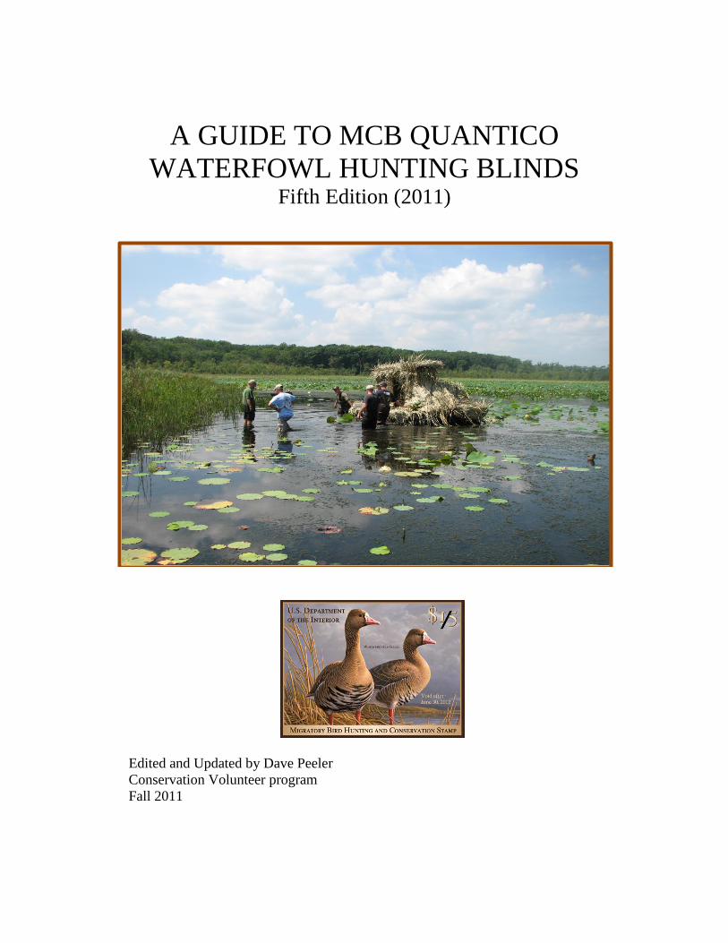
A GUIDE TO MCB QUANTICO
WATERFOWL HUNTING BLINDS Fifth Edition (2011)
Edited and Updated by Dave Peeler
Conservation Volunteer program
Fall 2011
Guide to MCB Quantico Waterfowl Hunting Blinds (2010)
2
Table of Contents
Introduction 3
Chopawamsic Creek 4
Blind 1 5
Blind 2 6
Blind 3 7
Blind 4 7
Blind 11 8
Blind A 8
Blind C 8
Chopawamsic Creek Map 9
Quantico Creek & Map 11
Blind 5 12
Blind 6 12
Blind 7 12
Blind 8 12
Blind E 13
Blind Hospital Point 13
Potomac River 14
Blind D 14
Blind 9 14
Blind 10 15
Potomac River Map 15
MCAF Shoreline Restricted Area Map 16
Lunga Reservoir 17
Blind 12 18
Blind 13 18
Blind 14 18
Blind 15 18
Lunga Reservoir Map 19
Smith Lake 20
Blind 16 20
Blind 17 20
Smith Lake Map 20
Dalton Pond 21
Dalton Pond Blind 21

Guide to MCB Quantico Waterfowl Hunting Blinds (2010)
3
INTRODUCTION
This guide provides information about and directions to waterfowl blinds located aboard Marine
Corps Base (MCB) Quantico. It also provides locations of the different boat launch points,
information about the different waterways, restrictions and safety concerns associated with the
hunting areas. This guide is not an all-encompassing document but is a tool to assist you in
getting safely to your hunting area. This document does not supersede MCB hunting regulations.
For the purpose of this guide, the waterfowl blinds will be associated with the water feature
where they are located. All directions will use the Game Check Station as the start point. The
section on each blind in this packet gives a distance from the boat launch. This distance is
always given in meters and is always a straight line distance. Maps have been included in the
text where thought to be appropriate. These maps highlight the different waterways accessed
when waterfowl hunting. Each section will provide a description of the water feature, directions
to boat launch points, and navigation tips to each of the blinds.
Upon reaching the blind, please make sure you have navigated to the location for which you
have a hunting pass. The interior of each blind has a placard marked with that blind’s
designation. While every effort is made to ensure that such placards are present, they may be
missing due to weather, vandalism, or other factors. It is therefore recommended that you’re
familiar with the blind you have checked out before you hunt from it. Likewise, you may want
to utilize the grid coordinates provided in this package and a GPS unit to assist you in navigation
to the blind.
The grid locations given in this guide are in the UTM World Geodetic System (WGS) 84, North
American Datum (NAD) 83 to 27. If you are using a military 1:50K or 1:25K, make note of the
version of the datum displayed on the map to make sure it is in WGS 84. You can use these
coordinates to enter into your Global Positioning System (GPS) to aid you in navigating to the
blinds. When using a GPS, make sure your coordinate system is set to display the WGS 84
Datum. The grids are listed to 8 digits (or 10 meters) of accuracy. The grid zone designations of
all grids listed are 18S.
This edition is an update that covers the current blind status (start of 2011 – 2012 hunting
season). Keep in mind that weather and time of year may affect the state of waterways and
conditions of the blinds and surrounding terrain. Any input or corrections to this guide can be
given to the game check personnel during waterfowl pass checkout at the Game Check Station.
Waterfowl Blind 100’ Rule “per MCB Bulletin 11015 dated 9 Sept 2011, at certain stationary
blinds, the hunting party can hunt from a position within a 100’ radius of the blind or at the
staked position (if the blind has one) to adjust for prevailing wind conditions.” The 100’ rule
applies to blinds 1, 2, 3, 4, 5, 6, 7, 8 and E. All blinds will be placarded with this rule and will
delineate whether or not the rule applies. If changes are made to this, the blind placard will
contain the most current information. All members of the hunting party must hunt from the same
position. If in boat blind, it must have current Va. Floating Blind license.

Guide to MCB Quantico Waterfowl Hunting Blinds (2010)
4
CHOPAWAMSIC CREEK
Chopawamsic Creek is located on the main-side portion of MCB Quantico. There are six
stationary blinds (Blinds A, 1, 2, 3, 4, and C) and one floating blind point, Blind 11 located on
the creek. The creek is located on the south side of Russell Road and runs parallel to it.
Chopawamsic Creek is a shallow body of water only several feet in depth at its deepest point
during mean tide. The creek has a small stream feeding it from the west and empties directly
into the Potomac River in the east. The creek bottom has a heavy build up of silt and is
extremely soft.
There are two boat ramps located on the creek, one on the western end and the other on the
eastern end. The first ramp is a small, unimproved, shallow ramp located on the western tip of
the creek and can be accessed from the wildlife viewing area off Russell Road. This is a shallow
ramp made of gravel. It is best suited for canoes, kayaks, and lighter boats with electric motors.
The parking area is limited and it is difficult to maneuver a car and trailer around the ramp. The
second ramp is a deep cement ramp located on the eastern portion of the creek and can be
accessed from behind Officer Candidate School (OCS). This ramp is lighted and easily
accommodates larger boats with its deep draft and solid construction. The ramp is steep and
when wet or covered with ice can be difficult to drive off. Use caution during winter months to
avoid sliding while backing down or driving up the ramp.
Chopawamsic Creek is subject to tidal changes with significant depth changes from low to high
tide, especially during heavy west or northwest winds. The current at the OCS boat ramp can
also be strong on a wind aided rising or falling tide making it difficult to launch or recover
watercraft. During periods of low tide the Chopawamsic may become un-navigable to boats
with motors. Because of the silt build up and the extremely soft bottom, getting out of your boat
and pushing may be dangerous. It is highly recommended that you know the tide schedule for
the day of your hunt so you are aware of the conditions moving to and from the blinds.
The Chopawamsic Creek has a large amount of aquatic vegetation during the summer and into
the fall. This can cause problems getting to the blinds. The channel heading west up the creek is
along the southern bank of the creek. Make note of the tidal marsh in the center of the creek that
bounds the channel on the north. It is visible during low tide. The two blinds most affected are
Blinds 2 and 3 located towards the western end of the creek. The extreme western end of the
creek is a marsh with a small stream flowing through it. The stream that flows through this area
can be shallow but has some deep holes. Navigating a large boat through this area is extremely
difficult. Blind 4 is located in this area of the creek. During the summer and fall you can also
expect to find aquatic vegetation growing in this area. Blind C is at the extreme western portion
of the creek and is not accessible from the main creek body. Access is granted by foot via a
designated parking area at the Transportation & Demonstration Support Area (TDSA).
MCAF Shoreline Restricted Area Map. This restricted area prohibits entering the
Chopawamsic Creek from the Potomac River or exiting the Chopawamsic Creek to the Potomac
Guide to MCB Quantico Waterfowl Hunting Blinds (2010)
5
River. (See P-18 below for the Restricted Area Map.) In the future this area will be marked with
buoys.
Directions to the Officer Candidate School (OCS) Boat Ramp: From the Game Check
Station you will head east on Russell Rd towards I-95. You will pass under I-95 and continue
heading toward the back gate of MCB Quantico. Please note that this gate is not manned 24
hours a day. Consult the current gate schedule if you are planning a very early arrival. After
driving through the gate continue heading east on Russell Road. The MPs may stop you at the
gate and ask to see your driver’s license and hunting pass. You will pass the Marine Corps
Exchange (Exchange) on your left side. As you continue on Russell Road you will pass the
MCCDC Headquarters Building and the Manpower Building. As you pass the Base Chapel you
will come to a traffic circle. You want to stay to the right as you approach the circle. You do not
want to turn into the circle. Just past the circle the road comes to a T-intersection at a stop sign.
At the intersection turn right and head over the bridge. You will pass the airfield on your left.
At the top of the small rise there will be a railroad crossing on your right side. You will cross
over the train tracks into Officer Candidate School. You will turn right at the first road. Follow
that road to a parking lot. Go straight through the parking lot and look for a gravel road in the
back of the parking lot. Follow that road to the bottom of the hill and the ramp will be on your
right hand side.
Directions to the Wildlife Viewing Area Boat Ramp: From the Game Check Station you will
head east on Russell Road towards I-95. You will pass under I-95 and continue heading towards
the back gate of MCB Quantico. After driving through the gate continue heading east on Russell
Road. The MPs may stop you at the gate and ask to see your driver’s license and hunting pass.
You will pass the Exchange on your left. As you continue on Russell Road, you will pass the
MCCDC headquarters building. There will be a traffic light directly in front of the building.
Just past the traffic light on your right there will be a gravel road and a brown sign indicating the
entrance to the Wildlife Viewing Area. Turn down this road and follow it to the boat ramp on
your right hand side. The road is a one-way road, so make sure you enter and exit correctly.
Blind 1: Blind 1 is located on the south bank of the creek approximately 1220 meters west from
the OCS boat ramp and approximately 1425 meters SE from the Wildlife Viewing Area boat
ramp. The blind is located on a small point of land with large coves on both sides. The grid
coordinates are 18S 297306, 4264378. The blind has a hill directly behind it. It sits out about
four feet from the hill in fairly shallow water. At high tide the water is roughly three feet deep.
The footing directly around the blind is very solid. Blind 1 has a dog door/ramp. The blind can
be seen from the Wildlife Viewing Area observation deck.
From the OCS Ramp: From the ramp you will turn west (left) and head up the creek. You
should follow the southern shoreline and look for a few distinct features. The shoreline is
generally straight with no major changes in appearance. Approximately 850 meters up, the
coastline will bend and create a cove. If you look to the western end of the cove you will see a
point of land that sticks out. This is the location of the blind. During low tides it can be very
difficult to navigate up the creek. Stay between the southern shoreline and the tidal flat north of
the channel. If you lose the tide, be prepared for a long difficult trip. Make sure you check the

Guide to MCB Quantico Waterfowl Hunting Blinds (2010)
6
tides and allow sufficient time to get to and from the blind, especially in the dark. The OCS
ramp is the closest start point for getting to Blind 1.
From the Wildlife Viewing Area Ramp: When you leave the ramp turn east (left). A short way
out from the ramp the creek will open up into open water. As you head east you will notice a
large marshy area on the right. Continue past this area and look for a cove on the eastern side of
the marsh. You will then notice a point of land sticking out. This is the location of the blind. If
you pass the marsh and start noticing a solid, wooded bank you have gone too far.
Consider the tidal flow when determining your launch point if you are paddling or using a
trolling motor. Even though the OCS launch is about 200 yards closer, this will be negated
going against an outgoing tide.
Blind 1 Alternate Shooting Stake: Blind 1 has an alternate shooting stake located about 75
meters to the west side of the blind (to the left as you look out from the blind). Head west from
the blind toward the cove. The is stake marked with reflective tape. As with all alternate stakes,
a flashlight will help you find the stake in the dark. Stakes are 4x4's with reflective tape affixed
to the top.
Blind 2: Blind 2 is located toward the western portion of the creek on a large marshy point of
land. It is located approximately 1800 meters west from the OCS ramp and approximately 890
meters SE from the Wildlife Viewing Area ramp. Blind 2 is on the edge of the marsh grass at
grid coordinates 18S 296829, 4264695. The footing around the blind is soft and uneven.
Exercise caution when moving around in the water in front of the blind. The water depth in front
of the blind is about three to four feet at high tide. Blind 2 has no dog door or ramp. The blind
can be seen from the Wildlife Viewing Area observation deck.
From the OCS Ramp: Head west (left) from the ramp up the creek. As you follow the southern
shoreline you will notice that the shoreline is fairly straight. Approximately 1000 meters up the
creek you will notice a cove and then a point of land. Beyond the point of land you will see
another cove and a large marshy area. As you approach the second cove, look toward the eastern
side of the marshy area. This is where the blind is located. Staying in the channel will help you
avoid some of the tidal flats. The creek is very shallow west of Blind 1 and navigation may be
difficult at low tide. Make sure you check the tides and allow sufficient time to get to and from
the blind, especially in the dark and if the wind is blowing from the northwest.
From the Wildlife Viewing Area Ramp: When you leave the ramp turn toward the east (left). A
short way out from the ramp the creek will open up into open water. As you head east you will
notice on the southern side (right side) a large marshy area that sticks out into the creek. The
marshy area has a cove on both the east and west sides. Head toward the eastern (far) side of the
point. The blind is located on the eastern side of the marshy area near the top of the cove.
Blind 2 Alternate Shooting Stake: From the blind head south (as you look out from the blind,
to the right) toward the wood line. Approximately 100 meters south you will find the alternate
shooting stake (approximately 15 meters out from the shoreline) marked with reflective tape. The
footing at the stake is somewhat better than the area around the blind but still soft and
crisscrossed with muskrat and beaver channels.

Guide to MCB Quantico Waterfowl Hunting Blinds (2010)
7
Blind 3: Blind 3 is located toward the western portion of the creek on a large marshy point of
land. It is located approximately 2000 meters west from the OCS ramp and approximately 640
meters SE from the Wildlife Viewing Area ramp. Blind 3 is on the edge of the marsh grass at
grid coordinates 18S 296635, 4264899. The footing around the blind is good but gets soft and
uneven farther away. Exercise caution when moving around in the water to the right and left of
the blind as there are beaver and muskrat channels that have sharp drop offs. There is also a
beaver lodge to the left rear of the blind that has a channel back to it and beyond that is a good
place to hide a small boat. Blind 3 has a dog ramp but no dog door into the blind.
From the OCS Ramp: Head west (left) from the ramp up the creek. As you follow the southern
shoreline you will notice that the shoreline is fairly straight. Approximately 1000 meters up the
creek you will notice a cove and then a point of land. Beyond the point of land you will see
another cove and a large marshy area. Go past the second cove and Blind 2 and around the
marshy portion of land that sticks out. As you pass around the marshy point the land starts to
wrap around and form another cove on the west side. The blind is located where the point starts
to bend back into the cove. If you lose the tide be prepared for a long difficult trip. Make sure
you check the tides and allow sufficient time to get to and from the blind; especially in the dark
or if the wind is blowing from the northwest.
From the Wildlife Viewing Area Ramp: When you leave the ramp turn toward the east (left). A
short way out from the ramp the creek will open up into open water. As you head east you will
notice on the southern side (right side) a large marshy area that sticks out into the creek.
Continue toward the western edge of that marshy area. The blind is located on the western edge
of the marshy area near the top of the cove. The blind can be seen from the Wildlife Viewing
Area observation deck.
Blind 3 Alternate Shooting Stake: From the blind head out towards the west (as you look out
of the blind, to the left) and follow the curve around to the south. About 100 meters you will
find the alternate shooting stake approximately 10 meters from the shoreline.
Blind 4: Blind 4 is the western most blind located on the creek and is not located on the main
body of water. It is located approximately 500 meters from the Wildlife Viewing Area ramp at
grid coordinates 18S 296988, 4265485. Blind 4 has a dog ramp but no door. The small creek
that leads into the blind is very shallow. Any boats with a draft of more than 1 foot will have
difficulty getting into the blind. The area around the blind is thick marsh with tall marsh grass
and small tress behind. The blind sits on the northern side of the creek and is oriented south
southwest. The footing around the blind is very soft and there are numerous obstructions both
above and below the water line. The small creek that runs past the blind widens out in front of
the blind to about 30-40 meters. The far side is moderately wooded. Retrieving downed birds
can be a challenge if they fall on land. Caution is recommended when walking outside of the
blind. Blind 4 has a dog ramp but no dog door into the blind.
From the Wildlife Viewing Area Ramp: Turn west (right) when leaving the boat ramp and follow
the creek through the marsh. The creek runs basically straight for about 200 meters and then you

Guide to MCB Quantico Waterfowl Hunting Blinds (2010)
8
will make a left turn. After you make the turn there is an old Blind 4 site about 150 meters up on
the left side. Go past this about 80 meters and the blind will be on your right.
Blind 4 Alternate Shooting Stake: Blind 4 has no alternate shooting stake.
Blind 11 (Floating Blind Point): Blind 11 is not an actual blind, but rather a spot reserved for
those with a floating blind license. A marked buoy located in the center of the creek toward the
eastern end at grid coordinates 18S 297704, 4264623. While every effort is made to keep the
location marked with a buoy, it is possible that strong winds, currents, ice, and other weather
phenomenon will have displaced, damaged, or completely removed the marker. Even when
marked, Blind 11 can be extremely difficult to find during hours of darkness. This remains true
even if you have previously utilized the location. A powerful flashlight will make it easier to
locate as you approach it in darkness. As a reminder, to hunt at this location you MUST have a
Virginia floating blind license. Since this buoy is in Prince William County, swans may not be
shot from it even if the hunter possesses a swan tag.
From the OCS Ramp: From the ramp you will turn west (left) and head up the creek. You
should follow the southern shoreline and look for a few distinct features. The shoreline is
generally straight with no major changes in appearance. Approximately 900 meters up the
coastline it will bend and create a cove. At this point, head due north (right). Roughly in the
center of the creek you will find the buoy. This location is on the northern side of the tidal flat.
You should follow the channel as if you were going to Blind 1 and then turn north after the tidal
flat. During low tides it can be very difficult to navigate up the creek. If you lose the tide be
prepared for a long difficult trip. Make sure you check the tides and allow sufficient time to get
to and from the blind, especially in the dark. When the creek contains heavy vegetation, it can
be difficult to get to the buoy.
Blind 11 Alternate Shooting Stake: Blind 11 has no alternate shooting stake.
Blind A: This is the closest blind to the OCS ramp at grid 18S 298310, 4264331. The blind is
located along the marshy area at the eastern end of the Creek. The blind is deliberately designed
to limit shooting to its direct front since the air facility and occupied buildings are to its rear.
Shooting aft of the blind is prohibited. Blind A has a dog door and ramp. There are some
underwater obstructions around the front of the blind. The ground is very soft around the blind.
From the OCS boat ramp: Head NNW for about 475 meters. The blind will be on the second
marshy island past the OCS ramp just past the entrance to a small body of water behind the
blind. It is clearly visible from the ramp. Since this blind is in Prince William County, swans
may not be shot from it even if the hunter possesses a swan tag.
Blind A Alternate Shooting Stake: Blind A has no alternate shooting stake. Shooting is only
authorized from within the blind.
Blind C: Blind C is located in a section of flooded marsh and forest land along the
Chopawamsic Creek near the Transportation Demonstration Support Area (TDSA), formerly the
Engineer Test Area (ETA). It is accessible by land only. Hunters should park at the TDSA gate
and walk to the blind. The TDSA gate is located at the end of George Mason Road which

Guide to MCB Quantico Waterfowl Hunting Blinds (2010)
9
intersects Route 1 just north of Telegraph Road. Hunters are not to block the gate regardless of
the open/closed status of the gate and they are not to drive through the gate. When parking,
hunters should park on the north side of the TDSA entrance road. There is a small sign marking
the proper parking area when hunting Blind C. The blind can be found using the directions given
below.
Along the wood line approximately 25 yards northeast of the TDSA gate is an old road that is no
longer in use and has ground level vegetation. To find Blind C, follow this road through the
woods until it dead ends (about 300 meters) at a very narrow section of the Chopawamsic Creek.
There is an old telephone pole at the end of the road. Turn right and follow the creek for about
300 meters until you come to an open marsh area to your right. In the middle of the opening is
an old beaver pond with a hen house nesting platform. There is no actual blind to hunt from.
Instead, there are four trees surrounding the pond that are marked with reflective tape. Hunters
may hunt within a 100 feet of any of these trees. Grid coordinates for Blind C are 18S 294682,
4265610. The creek can be several feet deep in places and the footing is generally firm with soft
spots on the beaver pond if it has water. It is a pretty good hike in the dark so plan accordingly.
Good idea to scout it out in daylight ahead of time in accordance with written procedures for
scouting. Recommend talking through your plan with someone who has hunted there before.
Note: If the gate is closed/locked; there is a foot path that parallels the gate fence to the north.
Follow that for about 15 meters to the end of the fence and find the road just past the end of the
fence.

Guide to MCB Quantico Waterfowl Hunting Blinds (2010)
10
QUANTICO CREEK
Quantico Creek borders the northern main-side
portion of MCB Quantico. There are seven
stationary blinds located on Quantico Creek
(Blinds 5, E, 6, 7, 8, F, HP). Use the ramp that
is located at the old Hospital Point (on the other
side of Quantico Town) to access the creek.
You can also access the creek from the
Potomac River. Quantico Creek is a large body
of water that flows directly into the Potomac
River. The tidal changes will rarely affect your
ability to navigate up and down the waterway
but the water does get very shallow in front of
the blinds at low tide. The creek has mostly a
hard bottom with few obstructions. MCB
Quantico abuts the southeastern portion of the
creek. The property located on the northern,
western, and SW portion of the creek is
privately owned. There are several private
blinds located on the creek as well as the blinds
owned by MCB Quantico. All of the MCB
Quantico blinds are on the southern bank
between the Railroad Bridge to the SE and the power lines to the NW.
The boat ramp will support large boats at high to mean tide only. There is a dock next to the
ramp. The ramp has lighting. The ramp is concrete and has a gentle slope. Large amounts of
sand often build up on the ramp and can make it difficult to drive off the ramp. The ramp
extends about 20 feet into the water from the high water mark (ends between 4th
and 5th
pier on
dock) and then drops off sharply. Be careful when walking around or near the end of the ramp.
There is about a 3-foot drop from the edge of the ramp to the bottom. You should also be careful
not to back the wheels of your trailer off the ramp when putting your boat in the water. Tide has
little impact on your ability to put in and take out small boats and canoes but can make it very
difficult to launch or recover large boats at low tide.
Directions to the Quantico Creek boat ramp: From the Game Check Station you will head
east on Russell Road towards I-95. You will pass under I-95 and continue heading toward the
back gate of MCB Quantico. After driving through the gate continue heading east on Russell
Road. You will pass the Exchange complex on your left. As you continue on Russell Road you
will pass the MCCDC headquarters building and the Manpower Building. As you pass the Base
Chapel you will come to a traffic circle. Enter the circle and take the second right and head
toward Quantico Town. Take a right at Potomac Ave. Go over the train tracks and head into
and through town. At the end of town take the last left on River Road before the marina. You
will go about a quarter mile and into the Marine Corps Systems Command campus. Take a left at
the sign for the boat ramp. Follow this road around to the right and down the gravel road to the
bottom of the hill.
Guide to MCB Quantico Waterfowl Hunting Blinds (2010)
11
Blind 5: Blind 5 is the farthest blind from the ramp. It is located approximately 2300 meters
west up the creek at grid coordinates 18S 299490, 4268782. Turn northwest (left) from the ramp
and go under the railroad bridge. Head up the creek toward the power line. As you head up the
creek watch the shoreline to your left. About 1500 meters up you will see a marshy area set back
from the creek. As you pass this area the shoreline will start to turn in and develop into a cove.
As the shoreline comes back around a small piece of land with a steep cliff behind it will jut out.
The blind is located on the point of land about 50 meters west of the cliff. The power lines will
be about 300 meters away and there will be a little marshy area just to the NW of you. Do not
cross under the power lines and continue up the creek as MCB Quantico ends at the power lines.
The blinds beyond the power lines are privately owned and not to be hunted with base hunting
passes. The bottom to the left is shallower and the footing is fair but uneven. The footing in
front of and to the right is fair and uneven and slopes off gently. Blind 5 has no dog door or
ramp.
Blind 5 Alternate Shooting Stake: The stake is in the same marshy area about 30 meters back
and to the left (NW) of the blind (as you sit in the blind). It is marked with reflective tape.
Blind 6: Blind 6 is located approximately 1500 meters from the ramp in a marshy area set back
from the creek at grid 18S 299989, 4268204. Turn northwest (left) from the ramp and go under
the railroad bridge. Head up the creek toward the power line. As you head up the creek watch
the shoreline to your left. About 1500 meters up you will see a marshy area set back from the
creek. This is where the blind is located. The water level around the blind is fairly shallow to
about three feet at high tide. At low tide the water may be several feet away from the blind. The
surface bottom is very soft and difficult to walk on. A lot of aquatic vegetation grows in the
water directly in front of the blind during the summer. This vegetation dies during the fall, but
can make getting into the blind during the early season difficult. Blind 6 has a dog door and
ramp.
Blind 6 Alternate Shooting Stake: Across the small cove and directly in front of the blind is a
sandy point of land. This point is on the main body of the creek. The alternate shooting stake is
marked with reflective tape.
Blind 7: Blind 7 is located approximately 1020 meters from the ramp in a small cove at grid 18S
300229, 4267774. Turn northwest (left) from the ramp and go under the Railroad Bridge. Head
up the creek towards the power line. As you head up the creek watch the shoreline to your left.
After passing under the bridge, you will come upon a point of land where Blind 8 is located. Go
around the point of land and stay near the southern (left side) shoreline. The water level around
blind 7 is fairly shallow and there is a hard surface bottom with some underwater obstructions.
Blind 7 blends in well with the shoreline and can be difficult to find in low light. Blind 7 has a
dog door and ramp.
Blind 7 Alternate Shooting Stake: There is a point of land just prior to reaching Blind 7 (as you
look out from Blind 7, it is on the point to the right). The stake is about 100 meters east from the
blind and is marked with reflective tape.
Guide to MCB Quantico Waterfowl Hunting Blinds (2010)
12
Blind 8: Blind 8 is located approximately 550 meters from the ramp on a point of land that sticks
out into the creek. The grid coordinates are 18S 300386, 4267322. Turn northwest (left) from
the ramp and go under the Railroad Bridge. Head up the creek toward the power line. As soon
as you pass under the bridge you will see a marshy point of land that sticks out from the left
shoreline. It is only about 450 meters from the bridge. Blind 8 is located on the eastern tip. The
blind sits in the open but is surrounded by a large amount of shore vegetation. The water level is
shallow around the blind, but drops off quickly as you move out into the open water. The
surface around the blind is fairly soft. Blind 8 has no dog door or ramp.
Blind 8 Alternate Shooting Stake: As you look out from the blind, the stake is located 150
meters to the left, along the shoreline, which goes to the point and continues west ending up
behind the blind on the other side of the point of land. It is marked with reflective tape. The
bottom is soft and uneven.
Blind E: Blind E is located approximately 2000 meters from the ramp between Blind 6 and
Blind 5 at grid 18S 299743, 4268372. Turn northwest (left) from the ramp and go under the
Railroad Bridge. Head up the creek toward the power line. About 1500 meters up you will see a
marshy area set back from the creek (Blind 6 area). As you pass this area the shoreline will start
to turn in and develop a cove. Blind E is located within this cove. The water level is very
shallow around the blind and may only be under water during high tide. The water in front of the
blind is two to four feet deep with good footing and some obstructions. Blind E has a dog door
and ramp.
Blind E Alternate Shooting Stake: There is no alternate shooting stake for blind E.
Blind F: Blind F is located approximately 770 meters from the ramp between Blind 8 and the
railroad bridge crossing the creek at grid 18S 300295, 4267015. Turn northwest (left) from the
ramp and go under the railroad bridge. Immediately after passing the railroad bridge, look to
your left and you will see an area set back from the main creek. Blind F is in this area
approximately 300 meters west northwest after passing under the railroad bridge. From about 50
yards out from the blind, the water becomes quite shallow. Through late summer and early
autumn the blind has upwards of 90% submerged vegetation cover in the surrounding area. Such
depth and vegetation may make it difficult to access the blind under power. The bottom is soft.
Low tide can leave this blind with 10 meters of mud in front of the blind. Blind F has a dog door
and ramp.
Blind F Alternate Shooting Stake: There is no alternate shooting stake for blind F. Shooting is
only authorized from within the blind.
Hospital Point Blind: The Hospital Point blind is located approximately 240 meters from the
boat ramp as you head toward the Potomac River at grid 18S 300915, 4266845. Turn right from
the ramp and head southeast toward the mouth of Quantico Creek. As you approach the River
there will be a point on your right. The blind is located on the shoreline immediately before the
point. Alternately, this blind can be accessed via land. From the boat ramp, turn right and head
southeast toward the mouth of the creek, following the shoreline. The blind is approximately the
same distance via the shoreline route. The blind has no dog door or ramp. Note: The water

Guide to MCB Quantico Waterfowl Hunting Blinds (2010)
13
surrounding the blind has a large amount of concrete and rebar refuse. Exercise caution when
approaching the blind via boat or when retrieving downed game. .

Guide to MCB Quantico Waterfowl Hunting Blinds (2010)
14
POTOMAC RIVER
There are three stationary blinds located on the Potomac River (D, 9 & 10). Due to the new
MCAF restricted zones (See Map on P-17), these blinds can only be accessed from the Quantico
Creek boat ramp if using a boat; From the Game Check Station you will head east on Russell
Road towards I-95. You will pass under I-95 and continue heading toward the back gate of
MCB Quantico. After driving through the gate continue heading east on Russell Road. You will
pass the Exchange complex on your left. As you continue on Russell Road you will pass the
MCCDC headquarters building and the Manpower Building. As you pass the Base Chapel you
will come to a traffic circle. Enter the circle and take the second right and head toward Quantico
Town. Take a right at Potomac Ave. Go over the train tracks and head into and through town.
At the end of town take the last left on River Road before the marina. You will go about a
quarter mile and into the Marine Corps Systems Command campus. Take a left at the sign for the
boat ramp. Follow this road around to the right and down the gravel road to the bottom of the
hill.
The blinds are located on the southern edge of MCB Quantico property. When Training
Area 3 is open for hunting, waterfowl hunters can drive on Chosin Trail, park, and walk down to
the river to get to blinds #9 and 10. None of these shore blinds have dog doors or ramps.
The river bottom is a hard surface with a gentle slope. The water depth can vary depending on
the tide from fairly deep to fairly shallow. The blinds are located on the beach, butted up against
the embankment. The water on the river can get very rough during windy or stormy conditions.
During such conditions, make sure you have a boat of sufficient size and power to safely
navigate to the blinds. At different times of the seasons, there may be crab traps marked with
buoys on the river. Watch for these especially during darkness. There are no alternate shooting
stakes for the Potomac River blinds.
Blind D: Blind D is located on the river south of OCS at grid coordinates 18S 298344, 4262530.
It is approximately 3 miles from the ramp to the blind. From the ramp head E out into the
Potomac River. Head south abeam the point of land when in the river. Motor past the marina,
Chopowamsic Island, and past the Air Facility (see restriction zone details). During darkness or
visibility below 3 miles or ceiling below 1000’, you’ll see the rotating beacon on old Larson
Gym on your right. Then you will pass the OCS chow hall and then the Auto Hobby Shop (large
lighted buildings located on the bank). Finally, there is a dock and boat ramp owned by the base
that is not for our use. Once past this start looking for the blind Go another 360 meters. There
are no major land features associated with blind D. It sits on the beach at the edge of the water
line and has heavy vegetation behind it. There is a large upturned tree stump that sits on the
shore 5 meters south (downstream) of the blind. The water level in front of the blind will vary
with the tide. A strong sustained west or south wind can move the waterline 10 to 20 meters
from the blind. There is a hard surface bottom generally free of obstructions with a gentle slope.
Blind D can be difficult to find in low light or foggy conditions.
Blind 9: Blind 9 is located on the river south of OCS at grid 18S 298170, 4262050. It is
approximately 3 miles from the ramp to the blind. . From the ramp head E out into the Potomac
Guide to MCB Quantico Waterfowl Hunting Blinds (2010)
15
River. Head south abeam the point of land when in the river. Motor past the base marina,
Chopowamsic Island, and past the Air Facility (see restriction zone details). You’ll see old
Larson Gym on your right. Then you will pass the OCS chow hall and then the Auto Hobby
Shop (large lighted buildings located on the bank). Finally, there is a dock and boat ramp owned
by the base that is not for our use. Once past this start looking for the blind. There are no major
land features associated with blind 9. It sits on the edge of the water line with the embankment
directly behind it. The blind sits out of the water on a sandy beach. The water level in front of
the blind will vary with the tide. There is a hard surface bottom generally free of obstructions
with a gentle slope. Blind 9 can be difficult to find in low light or foggy conditions.
Blind 10: Blind 10 is located on the river south of OCS at grid 18S 298032, 4261544. It is
approximately 2500 meters from the ramp to the blind. From the ramp head E out into the
Potomac River. Head south abeam the point of land when in the river. Motor past the marina,
Chopowamsic Island, and past the Air Facility (see restriction zone details). You’ll see the
rotating beacon on old Larson Gym on your right. Then you will pass the OCS chow hall and
then the Auto Hobby Shop (large lighted buildings located on the bank). Finally, there is a dock
and boat ramp owned by the base that is not for our use. Once past this start looking for the blind
D and then 9. There are no major land features associated with blind 10 (Blind 10 is about 500
meters south of Blind 9). Blind 10 is next to private property and there is a private blind located
roughly 150 meters south. There are submerged pylons just to the south of the blind. These
pylons run from the shoreline out into the water. Use caution when operating your boat around
the blind to avoid hitting the pylons. The blind sits on the edge of the water line with an
embankment directly behind it. The blind sits out of the water and is on a sandy beach. The
water level in front of the blind will vary with the tide. There is a hard surface bottom with a
gentle slope. Blind 10 can be difficult to find in low light or foggy conditions.
Need new map?
OCS Ramp
D
9
10
97 98
OCS Ramp
D
9
10
97 98

Guide to MCB Quantico Waterfowl Hunting Blinds (2010)
16

Guide to MCB Quantico Waterfowl Hunting Blinds (2010)
17
LUNGA RESERVOIR
There are four stationary blinds located at Lunga Reservoir, also called Lake Lunga
(Blinds 12, 13, 14, and 15). These blinds can be accessed from the boat ramp located by the
store/office at Lunga Reservoir. The ramp at Lunga Reservoir can handle boats of all sizes when
the water level is high. When the water level is low getting boats launched can be difficult.
Lunga Reservoir is a fairly shallow lake with a solid bottom. There are numerous places around
the lake that have underwater obstructions. These obstructions are generally tree stumps. The
majority of these stumps are located toward the upper end of the lake. Care should be taken to
avoid other obstacles such as sticks and logs, which are often found in the water. The blinds are
found on two different sides of the lake. Blinds 12 and 13 are on the north fork of the lake.
Blinds 14 and 15 are located on the south fork. The lake has two distinct forks to it. Looking
from the ramp you will have the southern fork directly in front of you. If you head out of the
ramp a couple hundred meters and then turn right and follow the lake around you will be heading
up the north fork of the lake. None of the blinds have dog doors or ramps.
Directions to Lunga Reservoir: From the Game Check Station head west along MCB-1 to
MCB-4 toward the FBI Academy. About one half mile past the entrance to the Academy there
will be a sign to "Lake Lunga". Follow the sign to the entrance of the lake. The boat ramp is
located at the entrance of the lake next to the office.
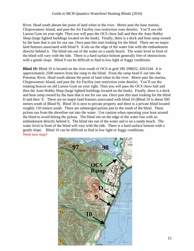
Blind 12: Blind 12 is located in the northwest corner of the lake. It sits on the edge of the lake
oriented to the east at grid coordinates 18S 283715, 4268933. The water level in front of the
blind can be fairly deep and there is a hard surface bottom. From the boat ramp you will want to
go to your right and follow the lake around to the north side. You will pass several campgrounds
on the eastern bank. As you approach the back end of the lake you will pass several large buoys
floating in the water. These buoys represent the edge of the SDZ (Surface Danger Zone) for live
fire ranges. You are not allowed to enter this area if the SDZ is in affect. However, if the blinds
are open and have been checked out at the GCS there you are cleared to enter the area, as the
SDZ is not in effect. Blind 12 is located about 700 meters past the barrels, on the left (south)
shoreline. It is located at the end of the lake on the south shore.
Blind 12 Alternate Shooting Stake: The alternate shooting stake for Blind 12 is located directly
across the water from the blind at the edge of “half-moon” field. It is marked with reflective
tape.
Blind 13: Blind 13 is located in the northwest corner of the lake. It sits on the edge of the lake
oriented to the east at grid coordinates 18S 283715, 4268933. The water level in front of the
blind can be fairly deep and there is a hard surface bottom. From the boat ramp you will want to
go to your right and follow the lake around to the north side. You will pass several campgrounds
on the eastern bank. As you approach the back end of the lake you will pass several large buoys
floating in the water. These buoys represent the edge of the SDZ (surface danger zone) for live
fire ranges. You are not allowed to enter this area if the SDZ is in affect. However, if the blinds
are open and have been checked out at the GCS there you are cleared to enter the area, as the
Guide to MCB Quantico Waterfowl Hunting Blinds (2010)
18
SDZ is not in effect. Blind 13 is located about 500 meters past the barrels on the south shoreline.
There is a large cove on both sides of the blind.
Blind 13 Alternate Shooting Stake: There is no alternate shooting stake for blind 13.
Blind 14: Blind 14 is located in the west end of the southern fork of the lake at grid coordinates
18S 283411, 4267585. It sits in a tiny cove just before the end of the lake. From the ramp go
straight up the lake and down the western fork. Twelve hundred (1200) meters from the ramp
you will see several large buoys floating in the water. These buoys represent the edge of the
SDZ (Surface Danger Zone) for live fire ranges. You are not allowed to enter this area if the
SDZ is in affect. However, if the blinds are open and have been checked out at the GCS there
you are cleared to enter the area, as the SDZ is not in effect. After you pass the barrels the blind
is another 1000 meters west. It will be on your left side as you travel west. The blind is located
in a small cove and sits on the south bank oriented north. Be careful in the area of the blind.
There are numerous rocks and stumps just below the surface of the water in the vicinity of the
blind. The water around the blind is not that deep but the surface around the blind is soft.
Blind 14 Alternate Shooting Stake: There is no alternate shooting stake for blind 14.
Blind 15: From the ramp head straight up the lake. You can see Blind 15 from the ramp. About
1200 meters from the ramp there is a large point of land on the north (right) bank. At the tip is
the blind at grid coordinates 18S 284270, 4267333. This blind is very easy to find. The water
around the blind is not that deep and the surface is basically solid. There is a large cove adjacent
to the blind and a large field directly behind the blind.
Blind 15 Alternate Shooting Stake. The alternate shooting stake is located in the field directly
behind the blind.

Guide to MCB Quantico Waterfowl Hunting Blinds (2010)
19
Ramp
1213
14
15Ramp
1213
14
15

Guide to MCB Quantico Waterfowl Hunting Blinds (2010)
20
SMITH LAKE
There are two blinds located on Smith Lake (also known as Aquia Reservoir). Smith
Lake is located on the west Side of I-95. Smith Lake has a restriction on boats. No gasoline
engines are allowed on the lake. You must use either an electric motor or hand-paddled boat.
Smith Lake is a man-made reservoir and provides water to the Stafford County. It is a deep lake
with very steep sides. Use extreme caution when walking on the banks and in the water, as there
are numerous drops, obstructions, and slippery banks. There are two boat launches. One is on
the northwest fork and the other on the southwest fork. Both blind locations are on the north
bank of the lake and are best accessed from the northwest boat launch. These directions are to
their current locations. There are no alternate shooting stakes for these locations. There are no
dog doors or ramps for these blinds.
Directions to Smith Lake: From the check station head west along MCB-1 until you come to
the firehouse. Turn left at the firehouse onto MCB-2. Two miles down MCB-2 you will come to
Smith Lake road on your left. If you enter into Camp Barret, you have gone too far and need to
turn around and head back. Go down Smith Lake road. The road is a graveled road surface and
only one car wide. About a mile down the road you will come to a split in the road with signs
directing you to Smith Lake boat launches. Stay to your left and keep left to go to the northwest
launch. Follow the road into the parking area and the ramp will be on your right.
Blind 16: From the ramp follow the
shoreline around to the left. The lake
will split with a major fork to the left or
northwest and a minor fork to the right
or northeast. Keep following the
shoreline around to the left. Head
upstream to where it narrows
significantly. The fork will run north,
then curve to the south before it curves
back to the northwest. The blind is
located past this bend. Blind
coordinates are 18S 289718, 4263514.
Blind 17: From the ramp follow the shoreline around to the left. The lake will split with a major
fork to the left or northwest and a minor fork to the right or northeast. Follow the fork to the
right that runs along the Training Area 5A-5B boundary until you come to the end. The blind is
located in the small marshy area. Blind coordinates are 18S 290284, 4263841.
17
90 91
63
16
Ramp
17
90 91
63
16
Ramp

Guide to MCB Quantico Waterfowl Hunting Blinds (2010)
21
Dalton Pond
Dalton Pond is located in TA-13 on the west side of base and houses one waterfowl
blind. It is important to note that the training area is not required to be open to general hunting in
order to use this blind. Accessing the pond by vehicle will require consideration of the daily gate
schedule posted at the Game Check Station as there are multiple routes to the pond, some of
which may be closed at any given time. To access the blind, head south from the boat ramp
toward the far side of the pond. The blind will be on the eastern (left) shoreline approximately
550 meters from the boat launch. The blind coordinates are 18S 277092, 4271642. This blind is
also accessible without the use of watercraft. Facing the boat ramp, head south along the
shoreline until you reach the blind. Note, however, that you are still required to have a way to
retrieve your downed game. The pond itself is of moderate depth around the edges with depth
ranging from 1 – 5 feet. Down the middle of the pond is a somewhat deeper channel.
Submerged vegetation can be heavy at times and there are a significant number of submerged
pine trees throughout the lake. Please consider both of these things as you approach and
subsequently utilize the blind. The blind has no dog door or ramp.
Directions to Dalton Pond:
Via MCB-1/MCB-4/MCB-3
From the check station head west on MCB-1. Continue straight ahead at the intersection of
MCB-1 and MCB-4 to continue on to MCB-4. Continue past Lunga Park and you will come to
the intersection of MCB-4 and MCB-3. Turn right. Stay straight on MCB-3 for about 7 miles.
The entrance to the Dalton Pond area will be on your left hand side.
Via MCB-1/MCB-6/MCB-3
From the check station head west on MCB-1. One half mile past the fire station, make a hard
right turn to stay on MCB-1. Continue on MCB-1 for 7.6 miles to turn left on MCB-6. Stay
straight on MCB-6 until you can go no farther. Turn right. Dalton Pond will be on your left in
1.6 miles.
Via MCB-1/MCB-8/Tokyo Rd./MCB-3
From the check station head west on MCB-1. One half mile past the fire station, make a hard
right turn to stay on MCB-1. Continue on MCB-1 for 9.7 miles to turn left on MCB-8. Follow
MCB-8 for 1.7 miles to turn left on Tokyo Rd. Continue on Tokyo Rd. until it intersects with
MCB-3. Turn right. Dalton Pond will be on your left in .4 miles.


