24
1 A Historical Review of the Planning and Zoning of Rural Baltimore County, Maryland 1945 through 2014 December 2014

1
A Historical Review of the Planning and Zoning of
Rural Baltimore County, Maryland
1945 through 2014
December 2014

2
TABLE OF CONTENTS Page
Purpose 3
Setting 3
Introduction 4
Population of Baltimore County 1940-2010 5
Planning And Zoning – Theory And Practice 5
History of Zoning in Baltimore County 7
Review of Residential Zones 1945 -1955 7
Review of Residential Zones 1955- 1970 8
Review of Residential Zones 1970 -1979 9
Unique Elements in Baltimore County
The Plan for the Valleys 1962 11
The Urban Rural Demarcation Line 1967 12
Advent of the Resource Conservation Zoning Districts 1975 – 1979 13
Maryland Agricultural Land Preservation Program 20
Conclusion 21
Indemnification 22
Brief Biographies 23

3
PURPOSE The rural planning history of Baltimore County is a unique story that
should be documented and presented as a case history. This
presentation will describe how this Maryland County’s growth was
managed from the 1940s through the early 21st century. The
concentration will be on the rural area of the county. It is also important
to have an understanding of the early zoning history of the county which
is included.
SETTING
Baltimore County, Maryland, is located in the mid-Atlantic area of the
United States. While it surrounds Baltimore City on three sides, it is a
separate political subdivision, although even though it does have
significant strategic connections to Baltimore City. Baltimore City is the
urban core of the region and the primary source of the current
transportation network as well as the source of the public water and
sewer systems for both jurisdictions.
Baltimore County contains over 682 square miles of a diverse landscape
and is aptly referred to as Maryland in miniature. Like the state itself,
the county consists of distinct physiological provinces. Proceeding from
south to north these include a coastal area along the Chesapeake Bay, a
ridge and valley province in the central area, proceeding to an upland
Piedmont region with elevations reaching nearly 1,000 feet to the
Pennsylvania State line in the north.
The county is quite diverse in how its resident population occupies its
space. At the present time 2/3 [two thirds] of the population reside
within 1/3 [one third] of the land area while 1/3 [one third] of the
population reside in the remaining 2/3 [two thirds] of the land area.
How did this unique situation come about? What has been the
contribution of land use planning and zoning? What were the hurdles
that needed to be overcome in order to have the necessary land use and
related legislation passed? In spite of its location as part of a
4
metropolitan region, how was Baltimore County able to preserve much
of its significant land base, watersheds and open space in general? All of
these questions will be answered in the discussion below.
INTRODUCTION:
The year 2016 marks the 40th anniversary of the enactment of the
Resource Conservation (RC) zoning classifications in Baltimore County,
Maryland. These include the RC 2 Agricultural Zone, the RC 3 Deferred
Planning Zone, the RC 4 Watershed Protection Zone, and RC 5 Rural
Residential Zone. These classifications account for approximately 95%
of the county’s rural land. The remaining 5% area consists of
commercial and industrial zoning. Virtually all the land is outside the
county’s Urban Rural Demarcation Line.
It had become increasingly apparent to the three (3) Office of Planning
staff who initiated and prepared these resource zones that a lack of
understanding relative to the evolution of these zones exists among the
Baltimore County elected and appointed officials, county planning staff
and the population in general. Clearly, such an understanding would be
useful to all concerned and found to be a rather intriguing matter as
well. Remarkably it should be noted that prior to the enactment of the
RC zoning classifications, all of the county’s zoning regulations promoted
development; no conservation classification existed.
The three authors of the RC zoning classification, Pamela Budesheim,
Jack Dillon and Paul Solomon have long been retired from Baltimore
County and are of an advancing age. They have come together to recall
the details of this effort, which ran from 1973-1979.

5
POPULATION OF BALTIMORE COUNTY 1930-2010
For the purpose of this analysis, we will begin in the 1940s because it
was the period between 1930 and 1960 that the county’s population
skyrocketed from 124,565 in 1930 to 492,428 in 1960, an increase of
367,863 persons. This population boom continued through 1980 when
the previous average 10-year growth was 168,867 persons. The next 40-
year 10-year average growth was only 46,987 persons.
BALTIMORE COUNTY POPULATION 1930 - 2010
Year Population Increase
1930 124,565 1940 155,825 31,260 1950 270,273 114,448 1960 492,428 222,155 1970 621,077 128,649 1980 655,615 34,538 1990 692.134 36,519 2000 754,292 62,158 2010 805,029 50,737
PLANNING AND ZONING – THEORY AND PRACTICE What exactly is the relationship between planning and zoning? The textbooks describe planning as the art of analyzing and projecting the proper use of land for specific areas for a certain period of time. Planning deals with long-range goals and objectives. It is a frame of reference to guide the future development policy of the municipality. This exercise takes into consideration population projections, water and sewer, transportation, and other public services, commercial, office and industrial needs, revitalization, and natural resource protection and enhancement. zoning is a legal implementation tool that allows and

6
directs land uses of a community so that they are properly situated and reflect the objective of a plan. Typically this analysis takes the form of an official report that includes a land use map which is often referred to as a Master Plan, General Plan or Regional Plan, referred to here as “The Plan”. There are two primary tools that are used to implement The Plan: the capital budget and the zoning regulations. The capital budget sets forth the financial timetable to implement the various needs and improvements needed to implement The Plan, while the zoning maps and regulations set forth the physical direction that growth and development/ redevelopment will occur. The Plan is usually revised on a ten-year cycle that coincides with the census so that shifts and adjustments can be made according to population trend and economic and market directions. It is a very logical and systematic method of planning for the long term. Adjustments to the plan can be made in the interim on an annual basis through the capital budget, and sanctioned amendments to the zoning maps through a petition process provided they could be justified as being consistent with The Plan. Unfortunately this has not been the practice in Baltimore County. The county did not do a full Master Plan until 1972 so there was no plan to measure the capitol budget against. Currently the proposed capital budget is sent to the planning board by the administration for review and the planning board hears requests from the various county agencies and the public. The planning board may add, modify or cut specific requests before it is sent back to the administration which in turn may make additional changes before it is forwarded to the county council. The county council may cut from the budget but not add to the budget before it is adopted. Through this process the public, the various county agencies, the administration and the county council have the adopted master plan available by which they can evaluate and justify the requests. In an ideal world each request is evaluated as to how it complements The Plan.

7
Unfortunately even with an adopted master plan, budget requests are too frequently not based on The Plan. HISTORY OF ZONING IN BALTIMORE COUNTY
Review of Residential zones 1945 – 1955
The first Baltimore County zoning ordinance was created in 1945 and by
today's standards was extremely simplistic. It complied with the
standards upheld by the United States Supreme Court in that it directed
a separation of land uses by placing them into categories, such as
residential, business or commercial, and industrial. These various zones
established standards that controlled uses, lot size, height of building,
and property line setbacks. The original zoning regulations and maps
were not based on a land use plan because a full Master Plan did not
exist until 1972.

8
Review of residential zones 1955 - 1970 In 1955 the Baltimore County Charter was amended and the county went from a County Commissioner form of government to one featuring a County Executive, Administrative Officer and County Council with seven councilmanic districts. Each district is determined by population and not by geographic size. The adopted zoning classifications at that time still did not distinguish urban from rural. A general residential classification was assigned to the non-urban portion of the county, except for those parcels of land zoned for commercial or industrial use. It should be noted that most of the non-urban parts of the county at that time continued to exist in what would be in the future described as agricultural. Another major change occurred in 1955 when the zoning code was amended and all new zoning residential and industrial classifications were established. For the purpose of this discussion, we will deal primarily with the residential zones and their impact on the rural portion of the county. Along with the adoption of the new zoning regulations, new zoning maps were also adopted. The maps were in two parts: 1. A 1" = 1,000' map for a specific area of the county that reflect the
boundary of each zone and provides a bird’s eye view of that portion of
the county.
2. A set of 1"= 200' maps for each 1000 scale map, which are the official
zoning maps for the county.
A separate but equally important element are the adopted zoning map
description books that give a metes and bounds description of each
zone.* This was used in the event of a challenge to the location of a
specific zoning line on the 200-scale map. The new residential zoning
classifications were also somewhat simplistic in that they were divided
into minimum lot size zones, which included:
*The practice of using a written description for each zone is no longer used.

9
R 40 (min. Lot size 40,000 sq. ft.)
R 20 (min. Lot size 20,000 sq. ft.)
R 10 (min. Lot size 10,000 sq. ft.)
R 6. (Min. Lot size 6,000 sq. ft.)
RG. Residential Group home
RA Residential Apartment
Once again, there was no zoning category that recognized the difference
between the urban and rural areas of the county. In fact, the zoning
maps provided no specific designation for the non-commercial/
industrial areas except the use of the term "residual R 6" which in
practice meant that the county Health Department would determine the
minimum lot size for houses on a specific parcel of land.
This determination was generally based on percolation or “perk” tests
for septic systems. As a general rule, a one acre lot was ultimately
determined to be the minimum lot size. However there were some lots
of one half acre or less permitted to be recorded. These zoning
classifications remained in effect until 1970 with the adoption of Bill 100
by the county council.
Review of Residential & Rural Zones 1970 – 1979
In 1970, new zoning regulations were introduced through Bill 100-1970
which would again change the method by which residential zones would
be designated.
This legislation changed the residential designations from minimum lot
size zones to density zones. The theory was that by allowing
development to proceed using allowable flexible density units and not
rigid lot sizes a better design could be achieved. The densities would
range from 0.50 units per acre to 80 units per acre. The density would
be calculated with the following formula:

10
0.50 density = a efficiency unit, 0.75 density = a single bed room unit, 1.00 density = a two bed room unit, 1.50 density = a three or more bedroom unit. The change in zoning designations were as follows: Old R-40 -- now DR1 (1 density unit per acre) Old R-20 -- now DR2 (2 density units per acre) Old R-10 -- now DR3.5 (3.5 density units per acre) Old R -6 -- now DR 5.5 (5.5 density units per acre) Old RA -- now DR 16 (16 density units per acre) New RAE 1 (40 density units per acre) New RAE 2 (80 density units per acre) New RDP (1 house per acre)* New RSC (1 house per acre) Two significant exceptions existed from the density zoning concept. The Rural Deferred Planning (RDP) and the Rural Suburban Conservation (RSC) zones were originally proposed as new rural zones that would help stem the tide of sprawl type development in the rural areas by removing large lot sizes. The RDP as proposed by the Planning Board had a ten (10)-acre minimum lot size, and the RSC had a three (3)-acre, minimum lot size. The density calculations, therefore do not apply in the rural area. In a surprise move when they approved Bill 100-1970 it changed the minimum lot size for both the RDP and the RSC zone to one (1) acre. This completely undermined the intent of these two significant new zoning designations as proposed by the Planning Board. By their action the County Council opened a wide door for residential intrusion into rural Baltimore County
The passage of Bill 100 was still significant because it was the first time that there was recognition of the rural areas as separate and distinct from the urban areas of the county in regard to a zoning designation. Thus a launch pad was established for a more comprehensive approach at a later time.

11
THE PLAN FOR THE VALLEYS – 1962 Just north of what is now the Baltimore Beltway there exist landforms that have become known as “The Valleys”. These five liner valleys known as the Greenspring, Caves, Worthington – Belfast, Stringtown and Western Run are underlain by limestone, a prolific aquifer, and the soils themselves are mostly prime and productive class I and II soils. Historically, these valleys have been in large land holdings and used agriculturally for the production of grain and thoroughbred horses. Adjacent to these valleys are gently rising slopes leading to ridges that separate the valleys. At this time, a significant portion of the ridges were in forest, agricultural fields and scattered residential development. Another prominent limestone valley, located further to the east, the Long Green Valley has similar attributes. In 1961 a group of landowners had become increasingly concerned that as a result of the post WWII building boom, these valleys and ridges would be overrun with subdivisions and shopping centers. The group hired a land use planning firm from Philadelphia, Pennsylvania, Wallace, McHarg, Roberts and Todd (WMRT) to do an analysis and present a plan that would accommodate some growth while preserving the valleys, and the valley walls. As a result Ian McHarg, a Scot and landscape architect of some renown, took on this project, which later became a central thesis of his seminal book, Design with Nature. Basically, the plan recommended that a consortium be formed that would allow development on the ridges which would consist of small villages with limited commercial support and light residential development of the upper slopes. The valley floors would be preserved by paying the owners for not developing their property. The plan was presented to then County Executive, Spiro T. Agnew, who dismissed the idea because of concerns that every community would want to develop their own plans. (Ironically, that is something that ultimately did come about with the encouragement of the planning office)
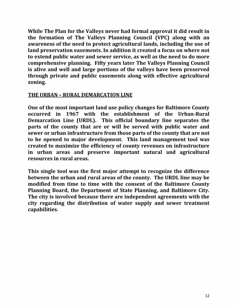
12
While The Plan for the Valleys never had formal approval it did result in the formation of The Valleys Planning Council (VPC) along with an awareness of the need to protect agricultural lands, including the use of land preservation easements. In addition it created a focus on where not to extend public water and sewer service, as well as the need to do more comprehensive planning. Fifty years later The Valleys Planning Council is alive and well and large portions of the valleys have been preserved through private and public easements along with effective agricultural zoning. THE URBAN – RURAL DEMARCATION LINE One of the most important land use policy changes for Baltimore County occurred in 1967 with the establishment of the Urban-Rural Demarcation Line (URDL). This official boundary line separates the parts of the county that are or will be served with public water and sewer or urban infrastructure from those parts of the county that are not to be opened to major development. This land management tool was created to maximize the efficiency of county revenues on infrastructure in urban areas and preserve important natural and agricultural resources in rural areas. This single tool was the first major attempt to recognize the difference between the urban and rural areas of the county. The URDL line may be modified from time to time with the consent of the Baltimore County Planning Board, the Department of State Planning, and Baltimore City. The city is involved because there are independent agreements with the city regarding the distribution of water supply and sewer treatment capabilities.

13
ADVENT OF THE RESOURCE CONSERVATION ZONING DISTRICTS
1975 - 1979
Following the failed attempt to discourage or limit unbridled residential
development, as well as development in general, outside of the URDL,
the pace of residential development in this large area accelerated in
what could be described as suburban sprawl or leap frog development.
Until William D. Fromm was appointed as Planning Director in 1973,
there was no apparent concern exhibited by senior staff within the Office
of Planning in regard to rural area planning. This included the previous
Planning Director, Deputy Director, and the four Planning Division
Chiefs.
Prior to the appointment of Director Fromm, OPZ leadership did not
encourage or elicit suggestions or recommendations from the planning
staff they headed. Immediately after taking office, Director Fromm met
with the entire staff and announced that he was not a planner per se, but
rather he was a planning administrator. Therefore, he encouraged the
staff to approach him with suggestions regarding planning related
projects that should be explored. He cautioned the staff that they
however would be responsible for the justification, research,
coordination and completion of their recommended projects once
accepted by him. This also was the advent of a period of “advocacy
planning” in the Office of Planning. Advocacy planning consists of an
area planner working in concert with the local community to prepare a
plan and present it to the planning board and the county council.
Rather than preparing a plan and presenting it to the community which
had been the previous practice.
Pamela Budesheim at the time was an experienced planner assigned to
the Community Planning Division as a sector planner for the rural area
of Baltimore County. Searching for a new or more stimulating
assignment, she asked Paul Solomon if he had any suggestions. At the

14
time, Paul was a staff member within the Division of Comprehensive
Planning and had been hired in 1970 as the county’s first environmental
planner.
Together they approached Director Fromm with the suggestion of
preparing a separate plan for the north county (NC), which includes the
entire area outside of the URDL. They explained that most of this area
was zoned in 1970 as Rural Deferred Planning, but actually became a
“rural residential development zoning district” when the county council
reduced the minimum lot size from a proposed 10 and 3 acres to 1 acre
(Bill 100). Hence, rural development was not being deferred or delayed,
as was the clear purpose of this zoning district. Director Fromm agreed
and assigned both Pamela Budesheim and Paul Solomon to prepare a
comprehensive plan for the north county to be immediately followed by
the designation of new zoning districts as needed.
The effort began with the preparation of a very large base map. (Keep in
mind that this was well before computers and GIS were available.) The
base map was pieced together using tax maps, which were manually
reduced to a consistent scale and taped together. Other notable aids
were aerial photographs, USDA soil maps, and subdivision development
files. All public lands were identified including schools, parks, the
reservoir land held by Baltimore City and State and Federally owned
land. Approved development plans that were not already plotted on the
tax maps were added. Streams and rivers were highlighted and
identified as to their stream order. By using these combinations of data,
a clear pattern of development trends emerged.
Most of the development (existing and proposed) was along the major
rural road routes. The process revealed how one subdivision led to
another, quite often on an adjacent parcel or farm, but sometimes
separated by working farms. Through field verification active farm
operations were identified as well as forested areas. When it was
completed, the map made clear that many agricultural operations were

15
threatened and many more would succumb to the development
pressure.
The price of farm land varied considerably depending primarily on
location. For instance, land in the fertile valleys where the large horse
farms were located would bring a higher price per acre while an upland
parcel of farmland would bring less per acre. Farmers, for example,
with 100 acres would be offered $600,000 to $1,000,000.00 for their
land. The disappointing factor was how readily a farm owner was
willing to sell for development and thereby place a huge burden on his
neighbors who may wish to remain in farming. It was well understood
that development in close proximity to a working farm creates serious
conflicts.
Another element of the study included the cost of services for a growing
rural population. Services included school bus transportation, trash
collection, road maintenance, and expansion of schools including
additional teachers. Provisions for additional support for the volunteer
fire companies and additional police protection were considered. By
example it was learned that the cost of trash collection in the rural area
was twice that of the urban areas.
Following this compilation of data, the planning staff formed an advisory
group called the North County Advisory Group. It was made up of a cross-
section of interests including farmers, other large landholders,
businessmen, community leaders, real estate brokers, the Extension
Service and others. The staff presented its data over a series of
meetings, which generated some energized discussions resulting in a
consensus with regard to appropriate land use decisions. The final
recommendation was that 5 new zoning classifications be prepared in
order to implement the plan for the rural county. These included:
16
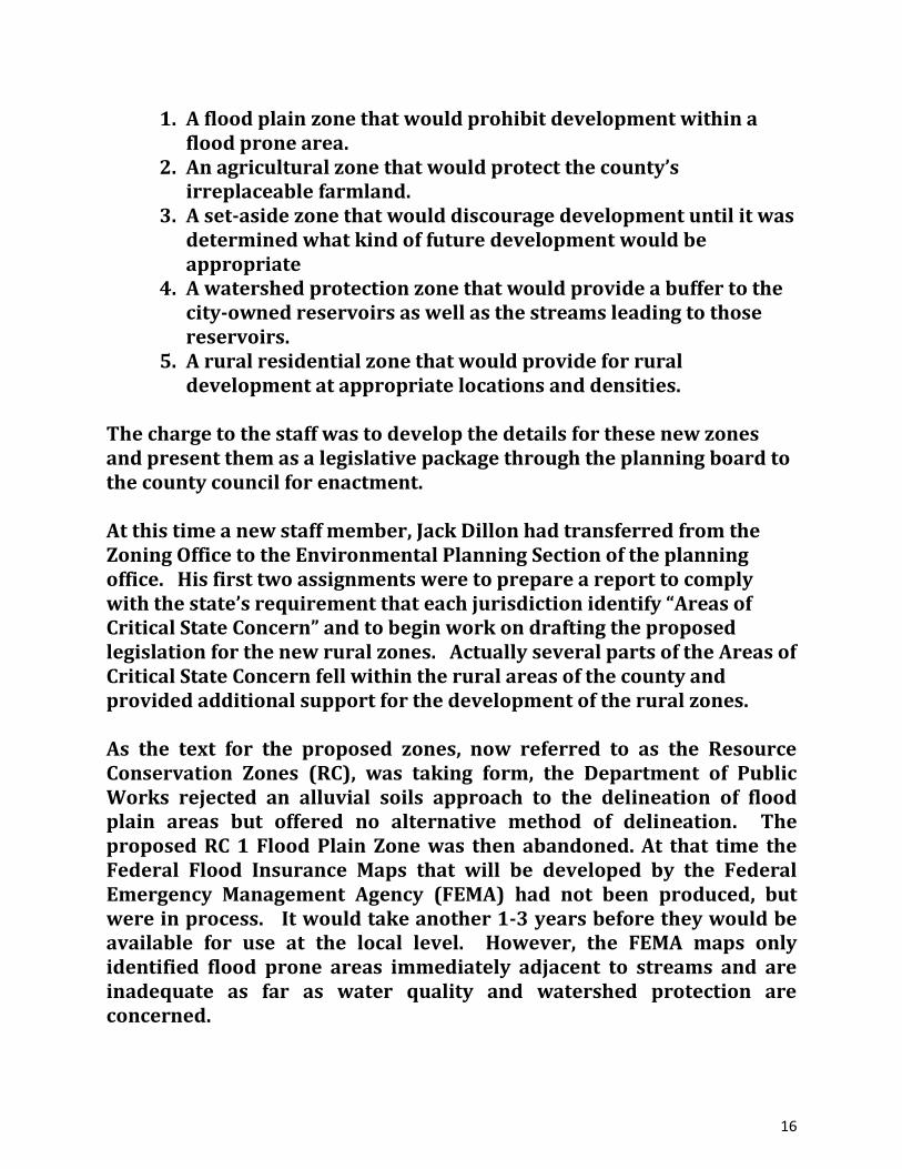
1. A flood plain zone that would prohibit development within a flood prone area.
2. An agricultural zone that would protect the county’s irreplaceable farmland.
3. A set-aside zone that would discourage development until it was determined what kind of future development would be appropriate
4. A watershed protection zone that would provide a buffer to the city-owned reservoirs as well as the streams leading to those reservoirs.
5. A rural residential zone that would provide for rural development at appropriate locations and densities.
The charge to the staff was to develop the details for these new zones and present them as a legislative package through the planning board to the county council for enactment. At this time a new staff member, Jack Dillon had transferred from the Zoning Office to the Environmental Planning Section of the planning office. His first two assignments were to prepare a report to comply with the state’s requirement that each jurisdiction identify “Areas of Critical State Concern” and to begin work on drafting the proposed legislation for the new rural zones. Actually several parts of the Areas of Critical State Concern fell within the rural areas of the county and provided additional support for the development of the rural zones. As the text for the proposed zones, now referred to as the Resource Conservation Zones (RC), was taking form, the Department of Public Works rejected an alluvial soils approach to the delineation of flood plain areas but offered no alternative method of delineation. The proposed RC 1 Flood Plain Zone was then abandoned. At that time the Federal Flood Insurance Maps that will be developed by the Federal Emergency Management Agency (FEMA) had not been produced, but were in process. It would take another 1-3 years before they would be available for use at the local level. However, the FEMA maps only identified flood prone areas immediately adjacent to streams and are inadequate as far as water quality and watershed protection are concerned.

17
The RC 2 (Agricultural Zone) was plotted utilizing criteria the staff had identified and designated as the major agriculture and associated forest areas. These criteria included areas dominated by prime and productive soils; farming areas not compromised by residential subdivisions; areas of adequate size and scope so as to adequately insulate farming areas from conflicting outside uses; and lastly, significant degrees of investment in farm-related capital improvements. The biggest issue was the need to limit the development level in order to protect and thereby sustain the agricultural industry. The staff was acutely aware that this zone would be the most controversial, for in order for it to be successful, the number of dwelling units permitted within the zone must be limited. A study of what other jurisdictions were doing revealed that while farmland loss was an issue of concern in only a few jurisdictions like Petaluma, California, Lancaster County, and York County, Pennsylvania had taken any action. It was decided by the planning staff to use a sliding scale of allowable development similar to what was being utilized in farming townships in southern York County, Pennsylvania bordering northern Baltimore County. Hence, tracts between 2 -20 acres = 1 development right, 20-40 acres = 2 development rights, 40 -60 acres = 3 development rights, 60-80 acres = 4 development rights, and 80 -100 acres = 5 development rights. Land with over 100 acres would receive 1 additional right for each 20 acres. The proposed RC 3 zone (Deferred Planning Zone) would be assigned to land just outside and bordering the URDL that could be considered for future development with the extension of public utilities. In order to discourage premature development of this land, a very low density of 0.3 units per acre was proposed. Any development that would be approved must be clustered on one-acre lots and platted so that when public utilities were provided in the future the lots could efficiently be served. Also, when and if land was rezoned to a higher density the density calculations would be limited to the remaining acreage. The proposed RC 4 zone (Watershed Protection Zone) would be placed over all the publicly owned reservoir land, adjacent lands as well as along streams and the watersheds that flowed into the reservoirs.
18
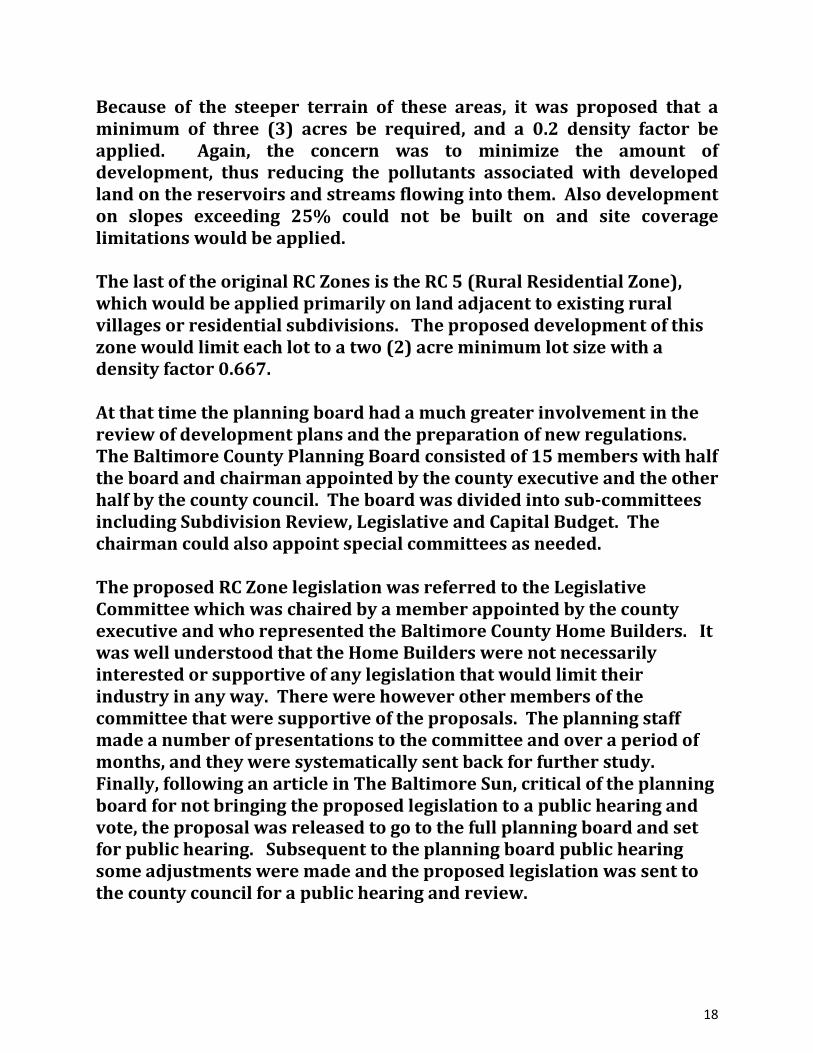
Because of the steeper terrain of these areas, it was proposed that a minimum of three (3) acres be required, and a 0.2 density factor be applied. Again, the concern was to minimize the amount of development, thus reducing the pollutants associated with developed land on the reservoirs and streams flowing into them. Also development on slopes exceeding 25% could not be built on and site coverage limitations would be applied. The last of the original RC Zones is the RC 5 (Rural Residential Zone), which would be applied primarily on land adjacent to existing rural villages or residential subdivisions. The proposed development of this zone would limit each lot to a two (2) acre minimum lot size with a density factor 0.667. At that time the planning board had a much greater involvement in the review of development plans and the preparation of new regulations. The Baltimore County Planning Board consisted of 15 members with half the board and chairman appointed by the county executive and the other half by the county council. The board was divided into sub-committees including Subdivision Review, Legislative and Capital Budget. The chairman could also appoint special committees as needed. The proposed RC Zone legislation was referred to the Legislative Committee which was chaired by a member appointed by the county executive and who represented the Baltimore County Home Builders. It was well understood that the Home Builders were not necessarily interested or supportive of any legislation that would limit their industry in any way. There were however other members of the committee that were supportive of the proposals. The planning staff made a number of presentations to the committee and over a period of months, and they were systematically sent back for further study. Finally, following an article in The Baltimore Sun, critical of the planning board for not bringing the proposed legislation to a public hearing and vote, the proposal was released to go to the full planning board and set for public hearing. Subsequent to the planning board public hearing some adjustments were made and the proposed legislation was sent to the county council for a public hearing and review.

19
The public hearings for both the planning board and the county council had overwhelming support from both the rural and urban communities, although there were some detractors that spoke on behalf of the development industry and some landholders that were concerned that the reduction of density would remove considerable value from their land. This testimony was largely targeted to the agricultural or RC 2 zone. The staff took the approach that the exclusivity of the zone would actually increase the current value of the land over time. This argument drew heavy criticism from land appraisers who totally disagreed. (Ultimately the staff was proven correct.) Finally in mid fall of 1975 the county council considered Bill 98-1975. The Chairman of the Baltimore County Council quizzed the staff member presenting Bill 98-1975 about the timing of the effective date of the legislation. His concern was to make sure that any development plan that was in the review pipeline would have enough time to receive all approvals before the legislation went into effect. Earlier the staff had requested a moratorium be placed on any new development proposals in the rural areas until the legislation was acted upon. This request was summarily denied. The staff concerns were justified, as there was a rush to have plans approved before Bill 98-1975 went into effect. This was the largest and most comprehensive zoning legislation ever proposed since the introduction of zoning in Baltimore County. The county council did approve the legislation with the effective date to coincide with the 1976 Comprehensive Zoning Maps. In 1978 the county, in preparation of the next 10 year Master Plan hired the consulting firm WMRT to help prepare a new Master Plan called the Growth Management Plan. This is the same firm that prepared The Plan for the Valleys in 1962, and they were therefore quite familiar with the county and its past history. The new Baltimore County Executive, James Smith, formed a new rural advisory committee to assist WMRT which was chaired by Wayne McGinnis, a prominent northern Baltimore County farmer.

20
As part of the master plan study the county executive requested the planning staff to compile data grouping the number of active farms in different acreage categories: Using the tax maps, farm land 25 -50 acres, 50 -75 acres, 75 -100 acres and over 100 acres were identified. The advisory committee debated the idea of a minimum lot size and recommended a 20 acre minimum while the Chairman recommended a larger acreage minimum. What was not known at the time was that many of these farm parcels contained multiple separate deeds, which later were interpreted as independent parcels that increased the number of development rights per farm. In the end, a revised RC 2 zone was developed establishing the development permitted as follows: “No lot of record lying within an RC 2 zone and having a gross area of less than 2 acres may be subdivided. No such lot having a gross area between 2 and 100 acres may be subdivided into more than 2 lots (total), and such a lot having a gross area of more than 100 acres may be subdivided only at the rate of 1 lot for each 50 acres of gross area”. The zone became known as the one house per fifty-acre zone, although that was not actually the case. MARYLAND AGRICULTURAL LAND PRESERVATION PROGRAM In 1980 Baltimore County enrolled in the Maryland Agricultural Land Preservation Foundation program. Under this program Baltimore County farmland could be preserved by the State of Maryland through the purchase of the land’s development rights from the landowner. This program augmented the county’s effort to preserve farmland through its own land use policies. The county’s emergence into this program now required the county to opt in to work with the state to set up and administer the program for the county. There being no money appropriated it fell to a member of the staff to run the program in addition to his normal duties. This entailed setting up an Agricultural Preservation Review Board, establishing review procedures, an evaluation system, and more. County Extension agent Max Buckle, the with the support of the Baltimore County Farm Bureau, recommended a goal of 80,000 acres be set for preservation. Almost immediately interest in the program began to grow and today the county has over 60,000 acres in this program. The

21
responsibility for administering this program as well as coordinating all other preservation programs was shifted from the Office of Planning to the Department of Environmental Protection and Sustainability, but now has shifted back to the Office of Planning and Community Conservation. CONCLUSION
Beginning in the early 1970s, Baltimore County has evolved from a
jurisdiction with no commitment to natural resource protection,
including farmland preservation, to one, that is considered a national
leader in this regard. It is quite remarkable that prior to the enactment
of the RC Zones in 1975, all zoning districts or classifications were
directly related to or promoted development; none to resource
preservation or environmental protection/ enhancement.
Since the enactment of the RC Zones, considerable updating and
enhancement of these zoning classifications has occurred. In addition,
the number of RC Zones has been expanded to include the RC 6 (Rural
Conservation and Residential Zone), RC 7 (Resource Preservation Zone),
and RC 8 (Environmental Enhancement Zone).
It should be noted that several individuals, rural community and
conservation organizations such as The Valleys Planning Council, The
Manor Conservancy, The Gunpowder Conservancy, The Long Green
Valley Association and, The Kingsville Community Association played a
significant role in the development and public support of these
regulations.
It must be emphasized that the RC Zones were established at a critical
time in the history of Baltimore County Planning. Otherwise the
opportunity to preserve the county’s land resources would have been
lost forever given the ongoing rate of development or land conversions
at the time and anticipated in the future.

22
IDEMNIFICATION:
This report represents the events and process that this project endured
to the best recollection and combined thinking of the three principal
participants.
Respectfully submitted:
Pamela Budesheim
Paul J. Solomon
Jack Dillon

23
Brief Biographies: Education; Pamela Budesheim Graduate of Towson State University, BS Geography Graduate of University of Baltimore Master in Public Administration Paul J. Solomon Graduate of Georgetown University, BS in History, minor in philosophy Graduate of Penn State, BS in from College of Agriculture Graduate of Penn State, Master’s Degree in Municipal Planning Jack Dillon Graduate of University of Baltimore, BS in Business with minor in Planning Certificate, Georgia Institute of Technology, Summer Institute of Planning Graduate of University of Maryland, University Collage as Paralegal Experience: Pamela Budesheim Planner Baltimore County Office of Planning, Community Planning Division Paul Solomon Senior Planner York County Planning Commission Senior Planner Baltimore County Office of Planning, Division of Comprehensive Planning, Environmental Planning Section Baltimore County Department of Environmental Protection and Resource Management as Environmental Planner and Administrator of Baltimore County Agricultural Land Preservation Program. Currently serving as Chairman of the Shrewsbury Township, York County, PA Board of Supervisors. Jack Dillon Baltimore County Bureau of Engineering, Special assignment to Residential Water use study at Johns Hopkins University,

24
Special assignment at the Baltimore City/ Baltimore County Analyzer Office Zoning Office of the Baltimore County Office of Planning and Zoning as Technician Comprehensive Planning, Environmental Planning Division as Planner Community Planning Division as 2nd and 3rd District Planner, initial Administrator of the Baltimore County Land Preservation Program. Senior Planner for Owings Mills Master Plan, Essex - Middle River Planning Assessment Executive Director of the Valleys Planning Council Past President of the Maryland Agricultural Resource Council Principal, Jack Dillon and Associates


