A Publication of the Foundation for Landscape Studies A Journal of Place Volume xıı | Number ı | Fall 2016 Essays: Linear Landscapes: Passing Through Places 3 Sandra Blakeslee: Biking in the Balkans Blair Braverman: Driving Dogs Anita Christy: Sacred Geography: The Shikoku 88 Temple Pilgrimage Julie Buckles: Paddle on an Inland Sea Peter Haring Judd: Land-, Sea-, and Cityscapes at Three Miles per Hour Exhibition 22 Therese O’Malley: Gardens of the World Museum Rietberg, Zürich Contributors 23
Transcript
A Publication of the
Foundation
for Landscape Studies
A Journal of Place Volume xıı | Number ı | Fall 2016
Essays: Linear Landscapes: Passing Through Places 3Sandra Blakeslee: Biking in the Balkans
Blair Braverman: Driving Dogs
Anita Christy: Sacred Geography: The Shikoku 88 Temple Pilgrimage
Julie Buckles: Paddle on an Inland Sea
Peter Haring Judd: Land-, Sea-, and Cityscapes at Three Miles per Hour
Exhibition 22Therese O’Malley: Gardens of the WorldMuseum Rietberg, Zürich
Contributors 23
2
These linear journeys were all embarked upon by choice. In reading about them, let us think with com-passion about those who set out in desperation on pre-carious conveyances toward uncertain destinations and unknowable futures. We whose lives have not been uprooted by war, poverty, and the destruction of place are indeed blessed by happy fortune.
With good green wishes and prayers for a safer, saner, and more economically and ecologically balanced world in the days that lie ahead,
Elizabeth Barlow RogersPresident
Alps rising out of the Balkan peninsula; Risan, an Illyrian fortress and site of several, now mostly destroyed, Roman villas; and Pr�canj, once a Venetian outpost and maritime center. Through-out their journey, they encountered bullet-scarred walls, abandoned buildings, and landscapes still strewn with mines – stark remind-ers of the civil war that rav-aged the region twenty-odd years ago.
Pilgrimages to holy sites provide time-honored itineraries. Anita Christy, who has traveled extensively in Asia for four decades, describes the 900-mile Shikoku 88 Temple Pil-grimage. She made the journey with her husband, David, after they had begun informal Buddhist studies at Columbia University in 2000. Because he had been diagnosed with cancer a
been shaped by wind, waves, and ice, and continues to be pruned, tweaked, and edited on a daily basis.”
Pedaling a bicycle up and down steep hills in for-eign parts is an adventure reserved for the hardy. But if you’re up to it, seventy-three-year-old New York Times science journal-ist Sandra Blakeslee, who continues to travel this way through places both near and far, says, “With regard to linear movement through a landscape, nothing beats riding a bicycle.” There are, of course, stops along the way, and her story of her recent nine-day trip with a group of cycling friends through Croatia, Bosnia-Herzegovina, and Monte-negro takes us to several remarkable places. There is, for instance, the ancient walled city of Dubrovnik, which “retains the feel of a medieval fortress with marble streets, baroque buildings, and Mediterra-nean gardens”; the Dinaric
rative of passing sights; by bicycle, boat, animal, or foot it is a bodily experience both visual and physical.
In her story of dogsled-ding in the Upper Peninsula of Wisconsin, Blair Braver-man describes the intimacy of her bond with her lead dog as they tear along the trail system of the Nicolet National Forest: “We are both fearful creatures prone to fearless decisions. Her job is to maintain one end of a string of impulsive animals, and mine is to maintain the other. Like a tin-can telephone, that line, when taut, keeps our minds con-nected.” Another Wisconsin resident, Julie Buckles, takes us on a canoe trip on Lake Superior with her husband and dog. The pace of their progress allows her to medi-tate on a landscape that “has
Usually the word “landscape” implies a visual frame of some kind – a scene that
may be viewed from dif-ferent angles and perhaps captured by camera, pencil, or paint from one or more stationary perspectives. But the landscapes we see most of the time, whether natural, designed, or some indeter-minate mélange of intention and neglect, are fluid and transitory. If we stopped to consider them critically, we might liken them to “mov-ing pictures” rather than still photographs.
With regard to these sequentially revealed landscapes, the mode and pace of locomotion as well as the elevation and angle of the spectator influence the nature of perception. From the air a landscape is a cartographic scroll unroll-ing below us; by train, bus, and car it is a linear nar-
Letter from the Editor
On the Cover:
Long-distance dogsled teams train-
ing on the Malangen Peninsula in
northern Norway. Photograph by
Blair Braverman.
short time earlier, they con-ceived of their pilgrimage – divided into three trips over four years – as an expression of gratitude for thirty years of marriage, a celebration in which the reader feels privi-leged to participate.
If New York City is your home, you don’t have to go far or stay away long to have the stimulation of travel. In his essay “Land-, Sea-, and Cityscapes at Three Miles per Hour,” Peter Judd provides a sampling of urban itineraries, including the Shorewalkers’ annual Great Saunter, a 32-mile walk around the perimeter of Manhattan. Judd revels in the ways in which these walks move through time as well as space. “There are always reminders of the city’s distant history on these treks,” even as one stumbles upon “new structures that the AIA Guide loaded into your smart phone knows nothing about.”
3
bicycle tourists. In fact, we didn’t see any other cyclists until we got back to the Adriatic, where high-end outfitters take their customers. We had Bosnia-Herzegovina and Montene-gro to ourselves.
Tomi explained that the appellations “Bosnia” and “Herzegovina” mark regional rather than ethnic divisions. Their borders, if they can be called that, are poorly defined and often disputed. The main difference we noticed was in the flag flown over each village and the currency accepted in local eateries (kuna, euros, and marks). Bosnia, in the north, encompasses four-fifths of the territory. We were headed toward Trebinje, the southernmost city in Herzegovina.
at the base of a dun-colored mountain. Our ride began with a long climb past an ugly mining operation cut into the
hillside. The day was hot, but as we pedaled further upwards to three thousand feet the air cooled, and we reached our first of many border crossings. (Bosnia and Montenegro are not European Union signatories, and Croatia is only a provisional member.)
Each crossing requires two stops. On the Croatian side, the guards were surly. A quarter mile later we rolled into the second post at the tiny Bosnian village of Ivanica, which was destroyed in 1992 and rebuilt in the early 2000s. A large dilapidated building near the crossing had bullet holes and shrapnel scars on its flanks. Here the guards were only slightly friendlier. No one seemed interested in American
Biking in the Balkans
In the past twenty years, I have ridden my bike all over the world: in Myanmar, South Africa, Tasmania, and a dozen other countries. With regard to linear movement through a landscape, nothing beats riding a bicycle. Assuming varied terrain, with plenty of hills interspersed with flats, you
will average about ten miles an hour. This is far faster than walking and blissfully slower than driving. As wind caresses your face, you encounter the world at a perfect pace; vistas are bigger on a bike. I don’t believe in planning much out before-hand; I just go. I never know what I’m going see.
Last September I took a cycling trip with eight friends to Croatia, Bosnia-Herzegovina, and Montenegro. Our Croatian guide, Tomi Coric, had agreed to lay out a route for us, and I assumed it would follow the Adriatic coast. Instead, he took us through the Dinaric Alps and into the heart of the Bal-kans, an echo chamber of Serbian aggression against Mus-lims and Croats. Tomi had fought in the war as a young man and throughout our trip supplied vivid descriptions of the conflict, which ended with the Dayton Accords in 1995. In this part of the Europe, we discovered, the landscapes reverberate with history and reveal centuries of hardship with every mile.
We met up in the ancient walled city of Dubrovnik. Known as the Pearl of the Adriatic, it retains the feel of a medieval fortress with marble streets, baroque buildings, and Medi-terranean gardens. You can walk the mile-long perimeter of thick limestone walls and peer down at shops, churches, narrow streets, and cats sunning themselves in cloistered backyards. This idyllic setting was shattered by violence in 1991, after Croatia and Slovenia declared their independence from communist Yugoslavia. The act outraged Montenegrin Serbs, who vowed that Dubrovnik would never be part of the new Republic of Croatia. From October 1991 to May 1992, the Serbs hauled heavy artillery onto the neighboring ridge tops – the slopes were too steep to get the cannons any closer – and hurled 650,000 shells onto the ancient city. More than half of the buildings were damaged, and 114 civilians were killed. You can still see broken rooftops, smashed tiles, and ruined courtyards.
There is only one traffic-clogged road out of Dubrovnik, so Tomi drove us ten miles along the coast to our starting point
Linear Landscapes: Passing Through Places
Old town Dubrovnik surrounded by
fortified walls. All photographs by
Bryan Shaner.
briefly ceded power back to Austria-Hungary. Then, after a fling with the Italians,
Montenegro became part of Yugoslavia.This area of the Balkan Peninsula served as a blood-
soaked border between Rome and Constantinople, and alternated repeatedly between Christian and Muslim rule. Throughout our travels, evidence of these religious and political divisions was visible in the architecture we saw, from crumbling Roman ruins to bullet-ridden Bosnian churches and mosques. Our trip gave palpable meaning to the term “balkanization.”
After pedaling through an unbroken string of beach towns amid heavy traffic, we stopped for the night at the comfy Hotel Xanadu, overlooking the sparkling expanse of the Bay of Kotor.
The Bay of Kotor is actually two bays connected by a nar-row waterway, surrounded by three-thousand-foot moun-tains. The mountains are devoid of vegetation or other signs of life, but the road loops around crystal-clear water for thirty-plus miles, and if you don’t look up there is plenty to see; the bay itself is under the protection of UNESCO, due to its rich cultural history. The first manifestation of that past we encountered was Our Lady of the Rocks, a tiny island in
4
an isthmus that we were circumnavigating. Legend has it that local fishermen spotted an image of the Madonna and Child on an islet in the sea in 1452. Ever since they have hauled more rocks onto the site, building up an island that now houses a church and museum. Devotees used to sink seized enemy ships there. The spot is very pretty, as was the traditional, handmade lace for sale in a viewing area at the side of the road.
Risan lay ahead, an Illyrian fortress and later site of huge Roman villas. All that is left are some lovely tiles and the remains of an acropolis. Since we were on bikes, moving quickly, we rolled on to Kotor, one of the best preserved medieval towns in the Adriatic, with a restored cathedral at its center. When we arrived, however, it was mobbed: sev-
eral cruise ships, each carrying five thousand passengers, had docked in the bay, disgorging swarms of tourists. Our response may have been ungenerous, but it seemed unfair that we could barely move in this fascinating place that we had worked so hard to reach. It was time to look up. The town is surrounded by Venetian fortifications with thick walls and massive stone steps that rise high above the city.
After lunch, we pedaled on to the lovely village of Pr�canj, a Venetian outpost and maritime center that was on the mail route between Istanbul and Venice. The waterfront was lined with stone villas owned or occupied by Europeans speak-ing English, French, and German; Croatia is chockablock with vacation homes. After arriving at the Hotel Splendido and swimming off its stone embankment, we ate dinner at a restaurant overlooking the bay, watching the lights flickering on the opposite shore.
The next day we experienced the classic Dalmatian coast landscape. To get to it, however, we had to suffer. A ferry across the Bay of Kotor took us back to the beach town of Her-ceg Novi. This time, however, we went in a different direction and rode up several steep hills to another border station, which ushered us back into Croatia. Zipping through a lush landscape of trees, shrubs, and nicely tended gardens, we made an abrupt left turn onto a road that descended toward the Adriatic. A second turn, this time to the right, took us onto a paved yet deserted lane with spectacular views. On our left: azure water. A spray of islands. Deep blue sky and crimson flowers. We rode through this landscape with a sense
The Dinaric Alps, which rise out of the Balkan Pen-insula, are made of karst – a porous yet hard rock that produces a fractured, hostile landscape. It is formed when soluble strata, such as limestone, dissolve under the erosive force of water. Since limestone is acidic, the water then slowly eats its way underground, forming fissures and channels. In time these can create huge under-ground caverns, sinkholes, and grottoes. The dramatic topography of the Dinaric Alps, featuring steep gorges and jagged escarpments, does not favor human habita-tion – although it provides good hideouts during political upheavals. Farming is difficult, because rainwater tends to fall through crevices, leaving the soil bone-dry. As we rode through these mountains, we saw mostly olives and grapes, crops that will tolerate arid, rocky soil, and mixed conifers and shrubs.
Before reaching Trebinje, we made a hard right turn up a very long, hot, steep climb, heading toward Montenegro. For noncyclists, an hour-long ascent may seem formidable but when you are on a properly geared, comfortable bike, it’s a form of meditation. You put your head down and simply keep pedaling. The most challenging part of this particular climb was the sweat pouring into our eyes.
After reaching the top, we stopped for lunch at a small restaurant, before pedaling through another fifteen miles of flat, unremarkable terrain. But then we crossed another border and found ourselves screaming downhill into Montenegro; we must have negotiated fifty hairpin turns before reaching the bottom. Here we turned left and entered the coastal town of Herceg Novi. To the left the 6,225-foot-high Mount Orjen – made of pure karst, and sprinkled with wildflowers – loomed above us. To our right lay the Bay of Kotor, a natural harbor on Montene-gro’s Adriatic coast.
This region has been subject to the tides of invading forces for millennia, and Herceg Novi, now an unat-tractive beach town, is emblematic of the phenomenon. It was founded on the site of a Roman fishing village and turned into a fortress in 1382 by a Bosnian king. After a stint as a medieval Serbian state, it was held by Bulgars, Turks, Spanish, French, Normans, Venetians, Russians, and Austro-Hungarians. The Ottomans held sway for four centuries, converting residents of Bosnia and Herzegovina to Islam. Later the Kingdom of Montenegro took over and
Cyclists gather near Bay of Kotor
listening to Tomi, second from left.
5
Back at Ivanica, we turned left onto a primitive track dot-ted with dung and broken stone. We were now moving into the interior of Bosnia-Herzegovina, where civil war had raged from 1992 to 1995. More than one hundred thousand people died as Bosnian Serbs supported by the Serbian government attempted to purge Muslims and Croats from parts of Bosnia. The Bosnian Serb leader, Radovan Karadži�c, forcibly dis-placed tens of thousands of civilians while destroying homes, religious sites, and cultural institutions. He also promoted the beating, torture, and rape of non-Serbs. This past March, he was convicted of genocide.
Our linear movement through the landscape now took on an ominous tone. For much of the next two days, we rode on an abandoned railroad bed that had been crudely paved over after the war. Trains no longer ran through this depopulated area; Muslim families who had lived and thrived here for cen-turies had been removed or murdered. Our track ran through a spooky no-man’s land with signs warning us not to stray from our path: unexploded land mines lay on both sides of us. Roughly one million are still scattered on the battlefields. We saw houses torn in half and a church with only one wall standing. We could feel the ghostly presence of once-thriving communities as we passed abandoned farms and vineyards. There were no birds, insects, or other signs of life. Only silence. When, after a couple of hours, we turned off the track and picked up a rural road, we passed through several villages that seemed to have barely survived the conflict. We were back in a karst landscape with impoverished farms and few inhabitants.
Our destination this day was the small village of Zavala, where a local family has built a welcoming guesthouse with hopes of reviving tourism. Sights include a Bronze Age exca-vation site; the nearly abandoned Zavala medieval monastery; and a wind cave, Vjetrenica. We chose the latter: the largest and most important cave in Bosnia and Herzegovina.
Standing at the entrance, you feel a strong blast of very cold air. Donning a hard hat, you lower your head and walk into the cave along wet, slippery rocks. (Some handrails are provided, but the layout would never pass muster with the American legal system.) After thirty or so yards, you can stand up and take in the scene: stalactites and stalagmites, flowstones, draperies, cascades, and other familiar cave formations.
Our guide, who probably gets few visitors (the cave was closed for many years after the war), was delightfully enthu-siastic. The wind cave is, he said, the richest cave in the world
several kinds of grappa before being served a flavorful beef dish and fresh vegetables.
During the war, the Konavle Valley was the site of several fierce battles. The family escaped to Dubrovnik, leaving everything behind. The house, the wine cellar, and all their vineyards were destroyed; the main house is still missing its third floor. After the war, the family returned and resumed traditional wine production, the younger generation taking the reins under the watchful eye of the octogenarian grandfa-ther. Everyone was optimistic about the future.
The following morning took us back into heavy traffic. I have extolled moving through the landscape on a bicycle, but having cars, trucks, and busses whizzing within inches of your unprotected body is terrifying. Fortunately, we made it unscathed back to the place where, on our first day, we had headed up into the mountains. This time, the scarcity of cars made the same drab climb a welcome relief.
of awe, blissfully grateful to be on bicycles. It doesn’t get any better.
Eventually we reached our destination for the night, Cavtat. Founded in the sixth century BCE by Greeks, it has been inhabited continuously for over two thousand years. The town was demolished by a powerful earthquake in 1667. You can still see submerged ruins in the local harbor. Too small for the cruise ships that plague Dubrovnik, Cavtat is a hidden jewel. Its mild Mediterranean climate is perfect for grow-ing oranges, kiwi, grapes, and herbs such as rosemary and lavender.
After we arrived at our hotel, Tomi had a surprise for us. He drove us in the van for forty-five minutes to the village Radov�ci�ci in the Konavle Valley, a fertile region fed by moun-tain streams. There we had a wonderful dinner in a three-hundred-year-old wine cellar, hosted by the Ljubic family at their family farm. We sipped a rich red wine and sampled
Looking across the Bay of Kotor.
6
in terms of subterranean life, with at least two hundred regis-tered species. Half are troglobites, small, translucent crea-tures adapted to life in the dark; we also saw spiders, snails, millipedes, and a blind salamander. Many are found nowhere else in the world. Our dimly lit trail took us about a mile to the “end” of the cave, but scientists reckon that it goes much further and may even reach the Adriatic.
Zavala and the wind cave overlook Popovo Polje, a huge karstic plain. (A polje is a field or basin formed when lime-stone collapses.) It’s a productive farming region, with the Trebisnjica River running through it. The waterway plunges and reappears as it winds its way across the plain, making it one of the largest so-called sinking rivers in the world. To prevent its water from draining through small holes in the polje, the river bed has been lined with concrete for forty-two miles.
Biking out of Zavala the next morning, we picked up the railroad bed and spent the next several hours slowly dropping in altitude. The landscape consisted of low shrubs and stubby trees, with virtually no signs of human or animal life. Finally emerging onto a real road, we passed through Ravno, a town that suffered heavy damage during the war; it had been on the corridor the Serbs used to attack Dubrovnik. Passing by Hutovo Blato, a large nature preserve that attracts thousands of migratory birds each year, we pedaled on to �Capljina, which calls itself the city of flowers. We were now in an ancient landscape once populated by a mysterious Bronze Age people called the Illyrians, who lived here for centuries before being wiped out by the Greeks and Romans. Traces of their civilization are still evident in high stone walls, bronze coins, sculptures, and burial mounds.
But �Capljina itself is a modern city. Our hotel, the Mogorjelo, was across the wide Neretva River that flows lazily through the region. The neighborhood seemed so peace-ful until you noticed the hundreds of bullet holes in the sides of buildings all around the hotel. The war was never far away.
The next day we rolled out of �Capljina under a gray sky, welcoming the cooler air. A half hour later we came to our hotel’s name-sake – the Roman villa of Mogorjelo, built in the early fourth century CE. A massive, stone waterwheel lay in the center for grinding
grain, and many of the stone walls suggested stables or stor-age areas. We were happily exploring the ruins when it began to rain. Luckily, there was a small café next to the site, so we parked ourselves and ordered coffee. An hour later it was still raining, so we ordered lunch.
We were headed for Mostar, the largest city in Herzegovina and its unofficial capital. Its most famous attraction, the Stari Most, is an arched stone bridge that elegantly spans the Neretva River. Built by Ottomans, it stood for 427 years until Croat forces destroyed it on November 9, 1993. Now rebuilt, this iconic bridge connects two worlds. To the west you see churches. To the east you find minarets. Here is another border between Rome and Constantinople, Christianity and Islam. The cobbled streets are now choked with souvenir shops and restaurants, but you can feel the vibrations of Bal-kan history in the very existence of the bridge.
Of course, these schisms continue to tear apart our worlds today. Our visit coincided with the mass migration of refu-gees from Syria, Iraq, Afghanistan, and North Africa into Europe. In the evenings we read about families turned back by soldiers at borders, forced to sleep in muddy fields, desper-ate for safety. This made a sign we saw on a Mostar front door
even more poignant: “Migrants welcome.” After some snacks, it was time to ride to �Citluk, a small
town on the way back to Croatia. By now it was very hot, and the scenery was unremarkable; half of us decided to climb in the van and let Tomi drive us there.
The following morning we missed a turn and found our-selves in downtown Medugorje, a popular pilgrimage site for Catholics. In 1981 six local children said they saw apparitions of the Virgin Mary on a hilltop. Now a million people come here each year, where they report seeing things like the sun changing colors or crosses in the sky. Some suffer eye damage from gazing into the sun. Although we kept our eyes on the road, we still couldn’t find our way out of town. Finally Tomi doubled back and rescued us.
From here we followed the Neretva past another two guard stations and back into Croatia. Now the river was defining our route, leading us down, down, down to the coast. A huge marsh spread out for miles around us, and the view, when we pulled over to rest our hands, was spectacular. When we reached sea level once more, we were zipping along the Pelješac, the second largest peninsula in Croatia, flying past fishing villages and seascapes in the cool breeze.
Soon we encountered another guard station – which, surprisingly, took us back into Bosnia and Herzegovina. As part of its exceedingly complicated history, Bosnia has twelve miles of coastline on the Adriatic that keep the country from being land-locked. The main town of Neum, where we stayed, was virtually deserted. Clus-tered against a sea wall, the houses felt dilapidated, devoid of Mediterranean charm. One sensed the inhabitants would love to attract more tourists, but don’t quite know how to make it happen.
Our journey continued along the Pelješac penin-sula through vineyards and coastal villages to the won-
The famous bridge, Stari Most, in
the town of Mostar.
7
derful town of Ston, located on an isthmus that connects
the peninsula to the mainland. From the town plaza, you can look up to see a massive stone wall snaking up the mountain above. Built in 1333, it is one of the longest fortifications in Europe, with forty watchtowers and five forts.
Hilariously, two of our group bolted out of Ston in the wrong direction, back the way we had come, and Tomi had to mount a chase to retrieve them. For the next hour, we rode through vast tracts of pine forests. Large swaths had been decimated by recent fires, giving the land a hollowed-out feel. After another long downhill, we arrived at a small port town and broke out snacks – a welcome reprieve before the stretch that awaited us. The climb was exceedingly long, steep, difficult, and hot, with the Adriatic on the left and ancient vineyards on the right. Small work crews and families cultivated the terraced fields, harvesting the purple grapes. When we stopped to nibble the fruits, they were plump and delicious.
At the top we encountered a tunnel that had no illumina-tion, but Tomi was there to help us through. On the other side, a wide road took us through a forested landscape to a port called Orebi�c. We boarded a ferry for the short ride over
to the famous island of Kor�cula. Exhausted, we ped-aled another six or so miles to a lovely seaside hotel in the town of Lumbarda. A large group of watercolor enthusiasts was staying at the hotel, venturing out each day to paint scenes of the harbor and country-side. Compared to us, they seemed very relaxed.
Only five miles wide and twenty-nine miles long, Kor�cula is covered with classic Mediterranean flora, including pine forests, and ruins from the many civilizations inhabiting the region. We spent the day meandering from the
island’s spine down to the coastal villages and back up again. In spite of our leisurely pace, we arrived early at our hotel in Prigradica, a waterfront town at the island’s other end.
In the morning, a private boat took us on the two-hour trip over to Hvar, an island playground for the rich and famous; the harbor was filled with private yachts. There we mounted our bikes for the last time, riding to the northern side of the island, to Stari Grad, one of the oldest towns in Croatia. On the way we passed hundreds, perhaps thousands, of small, stone terraces planted with lavender. The arduous work required to construct these terraces was painful to contem-plate, but lavender and rosemary grew in them with riotous abandon.
At the end of our journey we had ridden roughly 370 miles in nine and a half days and traversed at least three thousand years of Baltic history. We had seen not only evidence of ancient battles between Muslims and Christians, but also reminders of Europe’s worst ethnic mass killing since World War II as well as a new tide of refugees fleeing war-torn regions. Past and present are intertwined here – even for a tourist passing through on two wheels.
It rained on our last day as we packed up our bikes and took a ferry to Split, another ancient city on the Adriatic. With its famed Diocletian’s Palace and Game of Thrones film sets, Split was captivating. From here onwards we walked – although coming off a bike trip, when you stand still, you feel as if you’re still moving. – Sandra Blakeslee
Driving Dogs
The summer after I graduated from college, I walked the length of the Oregon coast. I wanted to take a long walk, and I chose that route because it seemed like the coastline would be flat and therefore pain-less. The four-hundred-mile trip took twenty-five
days, and when I finally crossed the California border on an unmarked stretch of sand, I had clicking hips, open wounds on the soles of my feet, and no desire to take a long walk ever again. But the trip had one lasting impact: I knew, my bones and muscles knew, how far four hundred miles was. I could look at a map of the country and have a very physical sense of what each distance meant.
The same is not true for dogsledding. I have an extremely poor instinct for how far my dogs have run, although I’m getting better at estimating miles per hour, and between that and winter’s fast-changing daylight hours I can usually make a half-baked estimate. Watch a fat Labrador shuffle to the kitchen or a greyhound chase a crow across a field: those are the outer limits of a dog team’s speed, and typically a long run will include every pace in between. On flat terrain, and with a good leader, my dogs hit their stride at roughly eleven miles per hour. Unlike me, they know exactly how far they’ve gone. If they’re used to training on a twenty-three-mile route, then they will always slow abruptly after twenty-three miles and begin to look over their shoulders and sniff snowbanks and otherwise indicate that their minds have drifted from the labor of pulling to the possibility of eating the frozen chunks of whitefish packed deep in the sled behind them. For this reason I try to keep their training runs unpredictable. Occasionally I hook up a team and cross the meadow behind my farmhouse, only to turn around and return immediately to the kennel, just to keep some particular smart-ass huskies from thinking that they have me figured out.
I have been dogsledding for ten years, ever since I was eighteen years old and moved to the Norwegian Arctic. Now I live on a farm in northern Wisconsin with sixteen Alaskan huskies. They laze and flirt for most of the summer, but as soon as the nights grow cold in September, we begin our fall training. The dogs pull carts or engineless all-terrain vehicles. The fall air is damp and smells like rotting leaves; the cart skids on rocks and splashes through brown puddles up to three feet deep. There are bears in fall, and bow hunt-
View of the Korcula coastline.
8
ers, and at night the woods turn a translucent black, the humid stillness cut only by the rattling four-wheeler and near-silent sweep of night birds.
Then the first snow falls, and the dogs start to pull sleds again, and the silence is real and the darkness is not. The snow glows in starlight, so that the woods in winter are never as dark as the tunnel of a fall trail, and there’s a loneliness and peace to the wilderness. Water freezes; field and lake look the same. The sled glides with a hiss.
On a typical winter run, after I’ve harnessed and arranged the team, we run from the dog yard into the meadow that makes up most of the farm and from there onto the adjacent trail system of the Nicolet National Forest. We’re mostly alone, although usually we pass a few snowmobilers an hour. Their rumble is audible from a mile off, and the dogs have learned to tune out the sound completely, though they perk in an instant at a cracked twig. Little can be seen through the dense woods, even after the leaves have fallen, so it’s always striking to enter the Zone, as my neighbors call the strip of land forty miles long and half a mile across where a tornado passed in 2007. The Zone is bright as tundra, but littered with broken trunks and jagged branches, traced with deer and mouse tracks. It reminds me of Norway. The dogs increase their speed by two miles per hour when they cross into the Zone.
If you don’t know the dogs that are pulling you, dogsled-ding is an athletic activity: you muscle around corners, run up hills to help the dogs, keep your knees loose as the runners wobble and bounce beneath you. If you know the dogs well, then the sport becomes at once easier and much more com-plex. It’s a chess game, each piece with its own agenda, and consists largely of managing unique and conflicting person-alities. Every dog has its own gait, metabolism, fitness level, cold tolerance, heat tolerance, friends, rivals, foot sensitivities, digestive quirks, and degree of resilience, and these patterns shift according to hormonal cycles, humidity, snow texture, altitude, etc. In practical terms, the best way for me to keep track of all these moving pieces is to not keep track of them, and instead trust my experience and instincts to do the work: my weight shifting by memory, my eyes unfocused, register-ing only the dogs’ rhythms and postures. Sometimes I talk or sing to the team, but mostly (my hands burning with cold, my eyelashes sticky with ice) I slip into a sort of hypnotic state.
My best lead dog, Jenga, will only lead the rest of the team if she is running beside a male and as long as an irritatingly chipper girl named Refried is not running right behind her. I cater to Jenga’s demands because she’s smart and fast, and I trust her to make judgments that I can’t make quickly enough, such as whether ice is too thin or which is the safest way around a fallen tree. Jenga is delinquent and once tore a ribbon of skin from her more attractive sister’s skull, but our minds are similar. We are both fearful creatures prone to fearless decisions. Her job is to maintain one end of a string of impulsive animals, and mine is to maintain the other. Like a tin-can telephone, that line, when taut, keeps our minds connected. In snowstorms, when I can hardly see past my
own mittens, I trust her to find the right path, and on roads and snowmobile trails I trust her to follow the laws of traffic. Mostly she does this beautifully, although she has a fondness for turning up driveways.
One of the most visceral aspects of traveling by dogsled is that you can, very easily, find yourself not traveling by dogsled at all. About ten miles into my first-ever dogsled race, in the thinly wooded hills overlooking Wiscon-sin’s Apostle Islands, I was running behind a sled and team borrowed from a friend – I didn’t have my own dogs yet – when my right foot punched through the snow, and I fell to my knees. The dogs kept going, of course, and I dragged behind them on my stomach, clinging to the handle of the sled. It wasn’t a big deal; I’ve been dragged countless times. The trick is to wait for the sled to slow and then clamber back up onto the moving run-ners. On this occasion, however, the dogs were coming to the crest of the hill, so I was low on time; the downhill to come was over a mile long, and there was no way I’d be able to right myself once we were careening down it.
I intentionally tipped the sled onto its side in a snowbank, flexing my feet to dig into the snow. I had just enough time to hop to my feet, dizzy with exertion, when another team
passed us, and my dogs took off, eager for the chase. I lost my grip on the handle and fell to my hands, watching my dogs gallop after a stranger, sled rattling behind them.
In seven years of mushing I had never lost a team; now I had, in a race no less, where spectators would watch my dogs cross the finish line without me. I had broken the first com-mandment of dogsledding: never let go of the sled. The day was warm, and I knew that the dogs would be fine and that, at some point, someone would think to look for me. But in the meantime I was stuck on a sunny mountaintop without even my snowshoes. Sitting and waiting seemed too depressing, so I trudged forward along the narrow trail, sinking to my knees with every third step.
I trudged for twenty minutes or so, trying not to cry. Then I heard barking. Sled dogs only bark when they’re standing still. I started jogging – which is to say, I trudged slightly faster – and came around a cluster of redwoods to see my
A 10-dog team trains on the eastern
flank of Michigan's Brockway
Mountain. Photograph by the
author.
9
dogs, all six of them, tied to a birch tree. Another musher had stopped his race to catch them and then waited for me, confident that I’d be coming up the trail.
Even in a race every musher is on the same team. It is us and our dogs against cold and storms and distance and landscape, against wild animals and exhaustion. I was lucky that day: it’s one thing to be stuck alone on a race trail with a crowd waiting to see if you emerge at the other end and a very different thing to lose your team on a solitary training run going ten or fifty or seventy miles. Or, say, in the middle of wind-blurred tundra when the temperature is minus fifty and your jerky and sleeping bag and dry boots are all packed in your missing sled. Sure, you can stuff your parka pock-ets with matches and protein bars and pray that’ll keep you thawed long enough to find some sort of help or civilization, although all that added weight – on top of the twelve pounds your parka weighs empty – will give you a killer backache. And you can buy an emergency beacon with one of those plastic buttons you can press anywhere on the planet to alert authorities to your dire situation. That is, if you trust a piece of plastic to save your life.
It was the fall after my first race, at the start of a new training season, when an old colleague wrote to me about buying some of his dogs. His wife had just had a baby and he was paring down his kennel; he had, he said, five young huskies that needed a good home at the very reasonable price of two hundred dollars each. I had moved onto my fiancé’s farm, and we had been thinking about getting our own dogs, so although thinking and doing are very different when it comes to acquiring living creatures, we said yes. I raced with my new team that winter and fell in love with them. In less than a year, I agreed to adopt fifteen more
huskies – and their equipment – from a musher who was get-ting out of the sport.
As a musher, I’ve moved through a number of landscapes. There was the Norwegian Arctic, bare and mountainous; there were the dense woods of Maine. The strangest land-scape I’ve crossed with dogs was a glacier in Alaska where I lived for seven months as a tour guide – bare, blinding, crack-ing, extending like an ocean in every direction. The dogs hated it. Without landmarks against which to measure prog-ress, the trail passed beneath us like an endless treadmill.
This past winter I entered the 240-mile Upper Peninsula 200 race, my longest to date. The trail ran between a highway and the gusty shore of Lake Superior before veering abruptly into a dense, craggy wilderness. We mushed straight through that first night. The snow blew so thickly that I couldn’t see the trail at all. I let my blind dog lead the rest of the team by smell alone. When the air cleared, the sun rose over a frosted, silent wilderness. The trees were crusted white with ice.
A hundred and seventy miles into the race at two the next morning, I came across a figure lying on its stomach in the middle of the trail. A dog team anchored to a snowbank rested nearby. I anchored my dogs, too, and they lay down.
It was eighteen below, a blue and starlit night, but it was hard to see through the cloud of my breath, which caught the beam of my headlamp in swirling billows. I hadn’t met
another human since leaving the last checkpoint three hours earlier. What I mean is: I felt very calm. I got off my sled and crouched beside the body and lifted its coyote-fur hood to see the face of a young woman from whom I had once purchased a wrinkled grocery bag full of used booties. Her skin looked silver and her eyelids twitched. I broke a strip from a frozen Kit Kat bar and touched it to her lips, which parted, and when she tasted the chocolate she was able to swallow a very small bite. I also had a few hand warmers, which I removed from my mittens and tucked against the pulse points in her neck and wrists. I took my sleeping bag from its stuff sack and draped it around her. Then I lay on my belly on the snow so that my face was close to hers.
“Hello!” I said loudly.Her eyes quivered and opened halfway.“You have pretty dogs!” I continued, and her eyes quivered
some more.And so on, as she gradually rose to consciousness. I
thought about loading her into my sled and heading for the next checkpoint, fifty miles away, but before I could decide, two snowmobilers came up the trail and then set off to get help. A few hours later an ambulance made its way up a nearby snow road and the musher was rushed to the nearest hospital, where she was treated for hypothermia. She turned out fine. Of course I stayed with the dogs. We lay on my sleep-ing bag, and Jenga and her prettier sisters curled up on my chest and legs as we watched the eastern edge of the sky turn orange and ate some fish chunks and the rest of the chocolate bar. I relaxed with the security of the dogs’ weight on my ribs and listened to their slow and separate breathing. The trees brightened through a halo of steam.
The thing about dogsledding, the magic thing that hap-pens when I know my dogs well and don’t let go of the sled, is that I’m never alone. Being human stops seeming like such a defining feature, and instead I feel like another body moving up the trail – a body capable of anxiety and foresight, sure, but not so different for those hours or days from any other warm thing. Maybe it’s the way my mind dissolves, loses track of numbers and miles; maybe it’s the way I slip into partnership with Jenga, lost in the silent camaraderie of shared leader-ship. Alert to circumstance. I have crossed wilderness without dogs and I have crossed wilderness with them, but only with dogs have I felt like part of the land. – Blair Braverman
Lead dogs Brewtus and Jenga wait
in the starting chute of the 2016
Upper Peninsula 200 dogsled race.
Photograph by Christina Bodznick.
10
Sacred Geography: The Shikoku 88 Temple Pilgrimage
My husband David and I had been trekking in Shikoku, the smallest of Japan’s four main islands, for only three days when I realized we were walking in a circle going nowhere. We were on the Shikoku 88 Temple Pilgrimage,
a 1400-kilometer (900-mile) journey that we completed in three trips over four years, following in the footsteps of the Japanese Buddhist monk and cultural hero Kukai (774–835). After gaining enlightenment on a rocky coastline in Shi-koku, Kukai traveled to China to learn the secret practices of Esoteric Buddhism, which he introduced to Japan as Shingon Buddhism. The Japanese consider him a “majestic watershed” from whom streams of culture flow.
Among the web of pilgrimage routes that anchor Japan’s spiritual landscape, the Shikoku 88 is one of the oldest and most revered. It is also the only circular pilgrimage route in Japan. Shikoku pilgrims circumambulate the island, sequen-tially visiting eighty-eight temples, hoping to gain enlighten-ment and accumulate merit by reciting the Heart Sutra – the shortest of the Prajnaparamita sutras that expound transcen-dental wisdom – as they go.
Shikoku is the only pilgrimage whose participants are known as henro, a word that designates both pilgrim and pilgrimage, enmeshing the pilgrim in the landscape both linguistically and spiritu-ally. The henro trail embraces a rugged coastline of city streets and woodland lanes, zigzagging occasionally into the vertiginous mountains of the interior. Its circular-ity manifests the charged concept of sunyata, or empti-ness, and the delusion of temporal goals. Shikoku thus functions as a mandala of sacred geography describing a cosmos that is both text and map.
David and I learned about the Shikoku pilgrimage when we began Buddhist studies at Columbia Univer-
sity in 2000, shortly after he was diagnosed with cancer at the age of seventy-six. Our attraction to Buddhism was both practical and aesthetic: David found religion and philoso-phy consolations; I was a lifelong student of Asian art. The pilgrimage seemed perfectly suited to our travelers’ instincts and Buddhist aims. At the time the Shikoku 88 was almost unknown in the West, but that only heightened our desire to go. We did not, as first, conceive our pilgrimage as a search for enlightenment (we thought we were enlightened), but as an expression of gratitude for thirty years of marriage. We planned to celebrate our October 2004 anniversary on the road.
Kukai, known posthumously by the honorific Kobo Daishi (Great Master Who Spread the Dharma), is the animating personality of the pilgrimage and its spiritual guide. The modern route is probably a consolidation of several earlier ascetic pilgrimages, some of which Kukai himself followed as a young mendicant monk. Kukai found enlightenment in Shikoku, but the principles he acquired in China gave him the framework to understand his experience. His Shingon philosophy incorporated features of existing Japanese Bud-dhist schools, as well as elements of native Shinto animism. Kukai compellingly argued that it was possible for devotees to attain enlightenment in this life, here and now. A believer did not have to suffer countless rebirths if he could recognize his
originally enlightened mind, which was all around him in a landscape encoded with truth. By the sixteenth and seven-teenth centuries, Shikoku had become a popular pilgrimage route for people seeking not only salvation but also, like us, worldly aims.
Traditionally the pilgrimage begins and ends on the island of Honshu across the Kii Channel with a visit to the 850-meter-high Mount Koya, the Vatican of Shingon Buddhism, where Kukai is enshrined in perpetual medita-tion in his mountain mausoleum. A lantern hall at his tomb houses ten thousand lamps that are kept burning; some are said to have been in continuous flame since his tomb was sealed over a thousand years ago. Towering cedar trees form an impenetrable canopy over the majestic Okuno-in, a vast cemetery of Japan’s privileged dead, where more than two hundred thousand tombs line the route to Kukai’s grave. But we had visited Koyasan, as it is known, a decade before UNESCO designated it a World Heritage Site and did not feel it was necessary to begin our pilgrimage there.
Instead, our journey started in eastern Shikoku at Ryozen-ji, the Temple of Vulture’s Peak, designated temple 1, and progressed clockwise in stages through Shikoku’s four pre-fectures, known in Buddhist parlance as dojos – places where religious rituals are performed. Temple 1 was in the ancient province of Awa (modern Tokushima Prefecture), the Dojo of Awakening. Wild Tosa (today the prefecture of Kochi), with its rocky Pacific coastline and temples few and far between, is the Dojo of Disciplining; Iyo (modern Ehime Prefecture), is the Dojo of Enlightenment; and friendly Sanuki (contempo-rary Kagawa Prefecture), where Kukai was born and the pil-grimage “ends,” is the Dojo of Nirvana. Traveling clockwise around the island had the benefit of numerical logic: temples are ordered chronologically. Pilgrims who move counter-clockwise – considered a more difficult practice because of the abrupt steepness of the terrain – are said to be more likely to meet Kukai coming toward them from the opposite
direction.With no expectation of
meeting Kukai, we caught a local train to Bando, the station closest to temple 1. The train arrived as sunset was burnishing the air the color of gold leaf. A middle-aged Japanese couple waited disconsolately, carrying staffs and dressed in white pilgrim attire. They spoke
Ryozen-ji (Vulture Peak Temple)
is a Shingon temple in Tokushima
Prefecture, located close to the
crossing point for pilgrims coming
to Shikoku island from the Kansai
region. The ascetic Yuben Shinnen
identified the temple as No.1 in his
Shikoku pilgrim guidebook of 1687
and since that time, Ryozen-ji has
been considered the traditional
starting point for the Shikoku
pilgrimage, though pilgrims may
begin wherever they choose.
little English and I only knew restaurant Japanese, but we exchanged pilgrim pleasant-ries. The husband was at the end of his pilgrimage; his wife had joined him for the final stretch. They pointed us in the direction of the temple, a five-minute walk from the station, but seemed reluctant to part. We bowed in admiration of the husband’s achievement, and
for the first time I felt anticipation commingled with doubt. We knew how to count from one to eighty-eight, but without a legible pilgrimage map, we could not even find temple number 1. Thus it was in the Bando train station that I had my first awakening: I was unprepared.
The innkeeper at the ryokan where we had reserved a room did not speak English, but our foreignness helped to iden-tify us. After steaming baths and a simple dinner of fish and
11
rice with the other guests, we bowed and retired to our rooms. When we rose early the next morning and walked to the temple, it proved easy to find. We followed the sound of gongs, chanting, and the cicada-like hubbub of departing pilgrims giving alms and receiving blessings for a safe journey. Filaments of incense drifted heavenward, perfuming the fall air. We had no one to pray for us, so I lighted three sticks of incense, stuck them upright in a large bronze basin, and positioned myself close to a group of pilgrims in the hope that the group bene-diction would spill over onto me. David sat on a banister, watching the commotion. In a reversal of our custom-
ary roles, he was content to observe, and I was eager to join the fray.
Before leaving, I stopped in the pilgrim shop at Ryozen-ji and bought a white cotton jacket for myself, a pilgrim vest for David, and a brocade prayer stole for us to share. We had not planned to outfit ourselves in pilgrim kit, but seeing other pilgrims made me want to emulate them. Putting on the white robes was an unpremeditated step toward an aware-ness of Non-Self. I eschewed the traditional conical sedge hat but purchased a white shoulder bag that held small-denom-ination coins for temple offerings, prayer beads, incense, matches, and candles. There were also slips of paper with an image of Kukai, made to be inscribed with the pilgrim’s name and sometimes an address and a petition or vow the pilgrim hopes to fulfill.
These papers, which are imbued with sanctity and healing properties, are deposited at temples and also used as calling cards to exchange with fellow pilgrims. A nokyo-cho – a kind of spiritual passport folded like an accordion – is inscribed by officials and stamped in red ink with temple seals to record the pilgrim’s arrival at each location. At the shop I also found a mystifying route map in Japanese. A pilgrim icon advanced through a crowded landscape where Japanese char-acters hung like banners. The text identified train stations,
temples, and inns in Japanese, but I could only recognize a few characters.
Kukai is embodied in a five-foot-long walking stick called a kongo-tsue. In this form, he travels with every pilgrim as a spiritual guide. The stick serves as a support for navigating steep paths or slogging up mossy temple steps in the rain, but it can also be used as a grave marker if the pilgrim drops dead en route – a not uncommon or unwelcome outcome of the pilgrim’s goal to leave the present life behind. Our white garb – the color of mourning – was a perpetual reminder of transience. A bell, tied to my stick with a silken cord, chimed the rhythmic sound of emptiness with each footstep.
We went out the next morning after an early breakfast, walking westward with our backpacks to the sun. I set a fast pace and was soon ahead of David, a position that gave me the illusion I was traveling alone. David walked, slow and steady, taking frequent rests, behind me. He was an invet-erate walker who in his seventies had slogged twelve hours at a crack in the Hindu Kush. Age and cancer had slowed him, but he loved me, so he let me forge ahead. He knew that soon enough I would be walking without him. He wanted to give me confidence while he still had my back.
I wanted to circle the autumnal island on foot in one visit – a plan I soon realized was untenable for David, who was still recovering from radiation treatments. Winding along superhighways, congested towns, and deserted coast-lines, the Shikoku pilgrim trail contrasted with our previous experience of manicured and clearly marked Japanese trails that allowed the mind to drift and the eyes to absorb the view. Instead, it forced us into a landscape of small, bright obsta-cles and Buddhist contradictions.
We agreed to go as far as interest and initiative led us. We visited the first eleven temples in the level plain of the Yoshino River Valley in mostly clement weather. Small dogs alerted farmers to our presence as we passed shoulder-high walls surrounding tile-roofed houses. Persimmons dropped from low-hanging branches, splattering brilliant patterns on kohl-colored, asphalt streets. An ancient kusonoki (camphor tree) was a signpost amid well-tended paddy fields.
Understanding began to dawn as we moved through the physical landscape, walking, losing our way, and finding it again. We had been reading Kukai’s texts. But to read is not to know; knowing requires somatic engagement. As Shikoku’s landscape and Buddhist practice shaped us, we learned to navigate a universe of seeming paradoxes, hoping to complete a pilgrimage while professing that “there is nothing to be attained.“
The stylized silhouette of the Japan
Railways map of Shikoku resembles
a vajra, a ritual implement used in
Shingon practice. JR, as the railway
line is known, connects all the
major cities and most of the towns
and villages of the island. Some
"walking" pilgrims occasionally use
trains, but reaching the temples still
requires walking from the station,
or taking a local bus or taxi.
12
Confused at one crossroad, I discovered a red henro silhou-ette no bigger than a postcard, pasted on a pole. It was my first decoding of the pilgrim map, and I was elated. I was like a novice who had just been shown how to look at a painting. The landscape opened, and I began to see. Soon I found signs everywhere: pilgrim silhouettes stuck to trees and poles and ancient stone markers with incised temple names and dis-tances under a pilgrim hand pointing the way.
Surprisingly, for an artist accustomed to engaging the world in visual terms, I scarcely noticed the Shikoku land-scape, a mostly monochrome backdrop of pines and sugi (Japanese cedar), whose pervasive pollen is the source of allergies in about one in ten Japanese. In familiar territory, I look up and outward as I walk, but in Shikoku, my focus turned inward and the landscape became a blurred back-ground to narrowing existential concentration. Rarely did my gaze extend beyond the toe of my hiking boot. If I raised my eyes to take in the view of the surrounding mountains and
fields of ripening grain, the smallest stone could cause a fall. I kept my eyes on the road and my mind empty of entanglements, conscious only of the sounds of my walking stick hitting the pavement and my tinkling bell.
Only when we arrived at a temple did I feel free to con-template our surroundings. Shikoku temple complexes are sacred enclosures of multiple buildings, each with two halls: one dedi-cated to the temple deity and the other to Kukai. Whether the site is urban or rural, each temple has a second “mountain name” that reflects the importance of mountains as sacred places, abodes of kami – native Shinto gods – and sites
associated with the dead. Many temples on the plains simu-late the strenuous experience of arriving at a mountaintop by
incorporating steps, sometimes as many as three hundred, in the approach to their main gates. One temple has more than a thousand steps to the inner shrine.
Now that we were henro, we felt compelled to enter the temple in a ritually pure state. Rinsing mouths and washing hands at the water basin on its threshold theoretically reori-ented our minds from the quotidian effort of walking to the observance of sacred ritual. But purification, as we quickly discovered, did not have a transforming effect on everyone. Group-tour pilgrims often created pandemonium as they rushed to complete rituals before their buses left. Even walk-ing pilgrims sometimes betrayed a hectic momentum as they jockeyed for space to light candles and incense and strike the gong, whose deep echo reverberated under droning chants.
In the wake of the bus pilgrims, peace returned and we could experience the subtle beauty of the temple precincts, which are at their most poetic in bad weather. The thick air would be saturated with the color of moss, and rainwater from dripping gutters would form wavelike patterns in the
drains. Smoke curled heaven-ward from a forest of incense sticks, and candles flickered in a glass enclosure. Barriers prevented us from approaching the gold-spangled altars, which were often shrouded in crepus-cular light. We performed our obeisance to deities closeted in the temple darkness. At these moments we were reluctant to leave, constrained by the impress of beauty. Standing on an exterior porch, sheltered by the deep overhang of temple roofs, we recited the Heart Sutra, whose words became dearer with each recitation.
Kumadani-ji, temple 8, in
Tokushima Prefecture, is said to
have been founded in the ninth
century by Kobo Daishi. It houses
the image of Senju Kannon, a
bodhisattva whose one thousand
arms and eyes promise limitless
awareness and compassion. The
main hall, or hondo, was destroyed
by fire in 1928 and has been rebuilt.
The Daishi hall and subsidiary
buildings have been designated
Prefectural Cultural Properties.
The pilgrimage route is signposted
with weathered stone stele mark-
ers, as well as small paper images
of henro, vajras, and other pilgrim
symbols, inconspicuously pasted
to lamp posts and traffic signs.
Photograph by the author.
13
According to Kukai, the Heart Sutra distills the entire essence of Buddhist teaching into fourteen lines. The core of the sutra is a meditation on emptiness: “No form, no feel-ing. No thought, no volition, no consciousness . . . No world of sight. No world of consciousness. No ignorance and no end to ignorance. No old age and death and no end to old age and death. No suffering, no craving, no extinction. No path, no wisdom, no attainment. Indeed, there is nothing to be attained.” Chanted twice at every temple throughout the pil-grimage, these words became ritual footfalls on our pathway to “no path,” building spiritual muscles when our physical muscles flagged.
Like many pilgrims, David and I embarked on our journey with only a dim awareness of the subtle subtext of the Shin-gon map. But as we moved through the living landscape on fair days and foul, climbing stairs, reciting mantras, receiv-ing gifts, exchanging kindnesses, nursing sore feet and ach-ing muscles, and inhaling the sweet perfume of reli-gious devotion, we absorbed Esoteric truths subliminally. At the very least, we accepted that we were gaining merit by being pilgrims regardless of how much of the journey we completed.
The greatest merit is acquired by walking the route, a commitment that can take up to two months, but most modern pilgrims adopt some combination of walking and vehicular transport – buses, trains, taxis, cars, bicycles, helicop-ters, and even skateboards. Pilgrims without the time or money to complete the full circuit may walk one of several miniature ver-sions of the pilgrimage, made from stones or soil from each of the eighty-eight sites. Other pilgrims complete the pilgrimage on multiple visits, as we did. Retirees join guided bus tours that hurtle around the
island in twelve days. Regardless of the mode of transporta-tion, pilgrimage is a physical and spiritual marathon.
We tried to reach our lodgings by late afternoon, in time to soak in a steaming bath. After a few days, I learned how to treat my walking stick with respect, shielding its crown with a brocade sheath and washing its splintered, gravel-scarred foot. Innkeepers, usually women, showed us how to stand the stick overnight in the room’s tokonoma, an alcove reserved for respected objects. Without the distractions of television or Internet, our rhythms changed. As the sun set, we collapsed on the floor under downy futons and fell into a dreamless sleep.
Some mornings I rose before breakfast to attend services and chant with the priests. Sitting on the floor with my legs folded uncomfortably beneath me, I was mesmerized by the triangular saffron figures sitting motionlessly before an altar crowded with candles, flowers, and swirling incense. The basso drone of the Heart Sutra, its staccato syllables chanted like the rosary of a ceaseless chain of causation, created a hypnotic euphoria. After an early breakfast, we were on the road again.
Our first existential challenge occurred as we contem-plated the thirteen-kilometer mountain path between the eleventh and twelfth temples, Fujidera and Shosan-ji. This section of the trail, which crosses three peaks, is known as henro korogashi, “where the pilgrim falls down.” With no Eng-
lish description to guide us and no mobile phone, I was wary of entering the damp wood alone, yet drawn to its emerald shadows. When David’s plaintive voice penetrated the gloam-ing – “Will you walk this section after I am gone?” – I prom-ised I would and turned toward the light. David befriended a car henro, a middle-aged man who was making the pilgrim-age in memory of his deceased son, and he agreed to give us a ride.
Shikoku is one of the few remaining places where pilgrims are offered settai (alms) – rides, sweets, lodging, sometimes money – from strangers. Initially I found this unsettling because I had nothing to give in return. A Japanese scholar of Esoteric Buddhism explained that our being was our giving: our pilgrimage allowed others to participate. By accepting settai, pilgrims become a human landscape of reciprocity and karmic potential – a field of merit known as fukuden.
We walked almost a hundred miles on our first visit, tak-ing cabs or hitching rides when the path was forbidding or the weather formidable. When a major typhoon threatened, we waited out the storm in a hotel in Takamatsu as the wind lashed the southern coast. Later we witnessed the destruc-tion it had wrought in Kochi Prefecture – roofless houses and downed trees.
At Cape Muroto, noted for wildness in all weathers, temple 24 overlooks the Pacific. On the cape, we looked for the cave where Kukai was struck by enlightenment at the age of nine-teen. He found it in an Esoteric meditation that he recited one million times “as if rubbing one branch against another in the hope of producing a spark.” Kukai wrote that “valleys echoed sonorously” and “the morning star brightened” as he meditated intently at dawn. In popular legend, the star flew into his mouth.
By the time we reached temple 31, Chikurin-ji, the Tem-ple of Bamboo Forest, on our anniversary, clouds and rain obscured the advertised panoramic view of the city. We took a toy-sized bus to the heavily forested Godai Mountain, but we could barely make out the spire of the temple’s five-story pagoda or the entrance to nearby Makino Botanical Garden. Because of heavy rain and Buddhist inclinations, we avoided the botanical garden. Instead, we celebrated our anniver-sary sitting on the covered wooden porch of an old samurai residence near the temple compound, reading aloud Kukai’s short treatise The Secret Key to the Heart Sutra. In the feudal setting of dark, unpolished wood and rock gardens, Kukai’s prescription for individual effort was diamond clear. We felt sheltered by his deep humanity and cleansed of extraneous burdens by the ceaseless rain.
The pilgrim path between Temple
11 and Temple 12, a distance of
roughly thirteen kilometers, takes
seven to eight hours and requires
an ascent of more than 1,200
meters, making it one of most
difficult passages on the Shikoku
pilgrimage.
14
For supper, we ambled down the mountain to a cozy road-side café where Japanese workers smoked and argued with collegial familiarity. After a meal of noodles and hot sake, the patron offered us settai: a bowl of deep orange, incomparably
sweet persimmons for dessert. The gift was a bright coda, signaling that the first stage of our pilgrimage was at a provi-sional end.
We returned to Shikoku in the spring of 2007 to travel from temples 31 to 65, walking amid flowering cherry blossoms and fields of wildflowers, taking trains and buses and occasion-
ally hitching rides. The following year, our final pilgrimage in Japan began the day Lehman Brothers filed for bankruptcy, a classic example of the delusion of “attainment.”
Throughout Kagawa, the last prefecture we visited, the kindness of strangers was unfailing. Locals stopped us on trains and in department stores to give us money, from five hundred to one thousand yen (worth approximately five to ten dollars). In Zentsu-ji, as we were leaving the temple celebrated as Kukai’s birthplace, a man beckoned us into his bicycle shop as we trudged to the train station: he had a gift for us. While chattering in rusty English learned during the Ameri-can occupation, he used a blowtorch to refashion three glass whiskey-bottle stoppers into massage tools that looked like Buddhist jewels. “I just realized,” he interrupted himself, “it’s my birthday. You are my birthday present.” Dumping an extra handful of candies and two bicycle-shaped key chains into
David’s hand, he exclaimed, “I will never forget this day!”Temple 85, Yakuri-ji, is a serene mountain sanctuary in
a small grove of chestnut trees said to have been planted by Kukai before he went to China. A pilgrim guide in melon-colored robes called his flock to prayerful attendance with a conch-shell horn. Towering over the temple was the thou-sand-foot-high Mountain of the Five Swords, its summit crowned with five boulders. The sanctuary was founded after the reputed appearance of five swords in the sky following the successful completion of a sacred rite.
At the diminutive old ryokan at Yakuri-ji, I lost my concen-tration and slipped down a flight of stairs, injuring my foot. My swollen toes turned the color of eggplants. The inn's own-ers took pity and drove us in relays to the next two temples. When we arrived by bus at temple 88, Okubo-ji, which had seemed so distant at the beginning of our journey, we were amazed to find it was only an hour away by car from temple 1.
Even though the Heart Sutra reminds us that “there is nothing to be attained,” temple officials marking the official end of the pilgrimage gave every qualified pilgrim a certificate of completion. We rested in the shade, listening to the chatter of bupposos, a rare migratory bird whose cry simulates the word for Buddhism’s Three Jewels – Buddha, law, and priesthood – and is therefore considered sacred. Solitary henro, including a woman who made the pilgrimage in memory of her dead husband, wrote in their journals. Bus-tour pilgrims posed for group portraits in front of the main hall, which is nestled at the foot of towering cliffs.
We returned to temple 1 as Shikoku veterans. I thought of the couple we had met at the train station, four years earlier. They had not wanted to leave this questing life and neither did we, but we knew we must. I realized we had begun our pilgrimage with the “persistence of a mistaken notion,” as Buddhists say. We walked to celebrate the attainment of a happy marriage when there was “nothing to be attained.” Our attachment to life, to the Shikoku pilgrim landscape, and to each other, concrete though these felt in the moment, were attachments to an illusion that would ultimately fade.
Many pilgrims said farewell to Kobo Daishi and the pilgrim life by leaving their walking sticks in a large bin at Okubo-ji. Despite all I had learned about nonattachment, I could not let go of mine. Six years later, though, as I said goodbye to my dying husband on a cold winter morning in New York, I realized I was ready – that when I entered the landscape of Shikoku, it entered me as well. – Anita Christy
Okubo-ji, Temple 88, is considered
the final temple of the Shikoku
pilgrimage, where henro leave their
walking sticks. The deep gong of
Okubo-ji’s temple bell and the tin-
kling of pilgrim bells were selected
for preservation by the Japanese
Ministry of the Environment to be
among the “100 Soundscapes of
Japan,” a collection of culturally and
environmentally symbolic sounds.
15
Paddle on an Inland Sea
The Lake Superior landscape has been shaped by wind, waves, and ice, and it continues to be pruned, tweaked, and edited on a daily basis. The water moves and shifts, even on the calmest days, with nearly imperceptible seiches sloshing like a liquid-
wave paperweight from one side of the lake to the other. The Chippewa called this body of water Gichigame, or big lake, and it is the largest freshwater lake in the world. The size of North Carolina, it borders two countries, one province, and three states. It is also deep – thirteen hundred feet at its deepest point. Artesian wells flow along its shoreline, where people line up to fill their containers. One doesn’t need to go far out into the lake to dip a water bottle and safely take a drink.
On a cool Sunday morning in May, I stand on a small boat dock looking across Bark Bay Slough to the barrier sand beach that created and continues to protect this freshwater estuary. At about 8 a.m., the sun is already above the trees on the barrier beach, casting a warm glow over the winter-worn slough. This estuary is a small wonder on the south shore of Lake Superior in Wisconsin. Imagine the outline of Lake Superior as a wolf ’s head: I am near the wolf ’s nose on the western side. The air temperature is fifty-five degrees and – most importantly for paddling – it’s calm. In contrast to the cold, inhospitable, and open lake, Bark Bay Slough hums with life. American toads and spring peepers trill a steady song, and a redwing blackbird on a cattail chimes in oh-ka-leeee.
Bark Bay Slough is a State Natural Area, located at the tip-top of Wisconsin, a thirty-minute drive across the Bayfield Peninsula from our house. The slough is cut off from Lake Superior by a barrier sand spit, making it one of the few shel-tered places for an easy recreational paddle on this intimidat-ing body of water. Kayakers prefer the sexier brownstone sea caves or the Apostle Islands – both nearby – but if a north-wester is blowing, battalions of colored plastic kayaks seek refuge here.
With our kids, twelve and ten, still asleep at home, my husband, Charly, and I are squeezing in a paddle, just the two of us. I untie one strap from our wood and canvas canoe, Le Strubel, and Charly unties the other. Our black rat terrier dog, Elton, bounces around the parking lot. We chat about
the things paddlers chat about – the weather, the forecast of future weather, the wind, the beauty, and the
deep sounds of those toads. “Is that really a toad?” I ask. Later a friend will confirm that indeed it is. There is not a person in sight, vehicle in the lot, or boat on the horizon. We lift Le Strubel off the roof of the truck as we have so many times before, set her down next to the dock in the water, and load in our few supplies – a cooler, binoculars, iPhones, water, camera – and Elton jumps in on his own. Elton is new to the family, and this is his first canoe ride.
Unlike so many locals who talk about being drawn to this region by Lake Superior, I didn’t move here for the lake. I came because I was in love with the man who would become my husband. We had searched for weeks for affordable land – driving back roads, looking at rundown farms and houses – when we eventually found a small hunting cabin that we liked. Young and broke, we hemmed and hawed about the condition of the cabin and the price. But then a friend asked if we had experienced the singing sands of the nearby
beach. We hadn’t. We drove a mile down the road and dis-covered a public, two-mile stretch of wild, white-sand beach, sandwiched between two trout streams. I took off my shoes and shuffled my feet through the billion-year-old sand and, indeed, it sang a squeaky song. We made an offer the next day.
I step from the dock into the front of our canoe, onto cedar ribs that I cut, bent, tacked, and shellacked myself. A hand-built E. M. White Guide, Le Strubel is the Julia Roberts of the water world – timeless, sleek, and sexy. My husband and I built her in 1999, under the instruction of master canoe builder Jerry Stelmok in Maine. I settle myself on the wicker seat and dig
my paddle into the slough’s cool, murky water. We not only built this canoe but have paddled thousands of miles in her. The motion of the first paddle strokes, the reactivation of my shoulder muscles, feels like going home.
Charly and I have paddled in Bark Bay Slough dozens of times. Today we’re going beyond the slough to revisit a twelve-mile stretch from Bark Point to Herbster. In May of 1999, we paddled Le Strubel past Bark Bay Point on the fourth day of a four-month, seventeen-hundred-mile expedition from our singing-sands beach on Lake Superior to Wollaston Lake in northern Saskatchewan.
With Elton shifting his twenty-eight pounds from one side of the canoe to the other, Charly steers us past cattails, tab alder shrubs, and other wetland vegetation laid flat by a long winter. We power ourselves past floating bogs to the screen of conifer trees on the barrier sand spit. The beach is peppered with weathered cabins. Built in the 1960s, the
Elton stretches his legs during a
canoe break on Lake Superior. All
photographs by the author.
16
houses do not have utili-ties and the only access is by boat. One A-frame is owned by friends. We have stayed here many times. The building has little value, but the location is priceless to someone who cares little about indoor plumbing and everything about place. Step out the front door for sunrise and onto a white-sand Lake Superior beach. Walk out the back door to check out the sunset or a flock of sandhill cranes that landed in the night, and you’re looking at the slough. Just three months earlier, friends walked across it, the same route we just paddled, for Charly’s February birth-day. We played bocce ball on the ice, fished for perch and northern pike, ate tiramisu, and called it a day before the late-afternoon sunset.
It is not yet Memorial Day, so no cabins are open. Paddling past a half-dozen structures with boarded-up windows and turned-over boats, we make our way the short distance to the Bark River and then Lake Superior. Canada geese fly over-head, a muskrat swims in front of us, and a pair of mallards takes flight. Canoeing together has been the spine of our relationship, holding Charly and me upright and keeping us on a similar path. I often state that all couples should have to paddle together before they marry. Paddling a canoe requires cooperation, focus, and hard work – with a touch of wonder and fun.
At the mouth of the river, we reach Bark Bay. We leave the protected womb of the slough, paddling against a series of small waves created by the push and pull of Lake Superior and the Bark River. The water is always changing the shape of things. At times it delivers enough sand to close the slough
completely, making the water rise until the next storm reopens the mouth and the river flows once more.
Three hundred and fifty miles long, Lake Superior is called an inland sea. I look out at where the shimmering, sun-speckled water meets the big sky. Bark Bay, a tilted horse-shoe, is shaped by two peninsulas, Bark Point and Roman’s Point. The bay provides a sense of security – of being held between the two points – and the budding aspen trees add a pop of electric green amongst the deep green conifers. But straight ahead is a wide-open expanse. No land and no pro-tection between here and Canada.
The allure and the danger of the open horizon are pal-pable. The lake’s combination of spectacular beauty, vastness, and lethalness has inspired its own subgenre of Lake Supe-rior mysteries. I set out a few years ago to answer the ques-tion of why there were so many Lake Superior mystery books. “When you write suspense or mystery, you’re always looking for obstacles, and Lake Superior can create its own micro- climate,” explained William Kent Krueger, author of the Corcoran O’Connor mystery series. “It’s simply that you can’t trust it. What it presents to you in one moment is not how it’s going to be in the next.”
To the north and west, beyond Bark Point, is Min-nesota. In Wisconsin, East of Roman’s Point, are the twenty-one islands that make up the Apostle Islands National Park, plus Madeline Island, the only populated island. The archi-
pelago is popular among sailors and kayakers, but the lake requires wisdom, experience, patience, and luck, even in the shelter of the islands. Several kayakers have died in recent years, not heeding the warnings of locals, miscalculating their own abilities, and failing to realize how quickly forty-degree water can debilitate even someone in a wetsuit.
Evidence of the power of this inland sea lies at its bottom, where more than three hundred vessels remain mummified. Near us a handful of shipwrecks rest in shallow water, close enough to shore that visitors can paddle over and observe the sunken boats below the surface. On a calm, hot day last sum-mer, Charly and I and the kids floated over the skeleton of the Lucerne near Long Island, one of the Apostles. Loaded with twelve hundred tons of iron ore, the Lucerne capsized in an unexpected, November 1886 snowstorm and sank. None of the crew survived. The next day, rescuers discovered three men tied to the mast, frozen in three inches of solid ice.
A different and far more recent November shipwreck was the 1975 sinking of an enormous freighter, the Edmund S. Fitzgerald. The tragedy was immortalized by the Cana-dian singer Gordon Lightfoot, whose ballad “Wreck of the Edmund Fitzgerald” became practically a binational anthem for this region:
The legend lives on from the Chippewa on downof the big lake they called “Gitche Gumee.”The lake, it is said, never gives up her deadwhen the skies of November turn gloomy.With a load of iron ore twenty-six thousand tons morethan the Edmund Fitzgerald weighed empty,that good ship and crew was a bone to be chewedwhen the gales of November came early.
Several rustic cabins are scattered
along the thin stretch of land that
separates Lake Superior from
Bark Bay Slough. The back door
(pictured here) faces the slough;
the front door, a white-sand
beach and Lake Superior.
17
Before the railroads, Lake Superior was the heart of the most important trade route in North American history, its dangers to paddlers notwithstanding. More than two mil-lion years ago, glaciers crept down from the north and scoured out the trough that became the Great Lakes through advances lasting tens of thousands of years. Through a quirk of geology, the glaciers carved a waterway from here to the ocean that was named the Voyageurs Highway during the seventeenth and eighteenth centuries. Lake Superior was a key transit point between the fur-rich interior of the North American continent and European markets. Goods flowed not only east to Montreal, via the St. Lawrence River, but also south to New Orleans, moving down the Brule River (thirty miles west of here) to the Mississippi.
We are paddling now along the lake side of the beach bar-rier. Instead of shrubs and trees, this is a stretch of the most pristine white-sand beach in the Midwest, and possibly in all of the Great Lakes. I look down through ten feet of water and see the hard, sandy ripples that were shaped by waves and mimic the appearance of the sandstone cliffs. As I dip my paddle into the water, we cruise past the front façade of the A-frame – the same one we paddled past on the slough side less than an hour ago and where we hosted Charly’s winter birthday party. I tell Charly that I’d like to spend the Fourth of July weekend here with the family. No chores, work obligations, or Wi-Fi – just the four of us and the dogs at the beach. I look over my shoulder and see Eagle’s Island, one of the Apostle Islands, to the east beyond Roman’s Point. Eagle Island is the second-smallest and westernmost of the Apos-tles. In the summer the park service closes it to the public to protect nesting birds.
Further east is Madeline Island, the largest Apostle. It is the only one open to private ownership and development and has long been the spiritual, commercial, and political
center of the Lake Superior Chippewa. The Chippewa people migrated and settled on Madeline and the mainland at an undetermined date, possibly by 1500 or even earlier. By 1640 other Native people as well as European explorers and fur traders had arrived. The region’s inhabitants paddled birch-bark canoes crafted in various sizes by Natives; they were the only cargo boats light enough to portage overland. “Genera-tions, perhaps even centuries, witnessed the perfecting of the art,” historian Grace Lee Nute wrote in The Voyager, “for it is no slight task to build a vessel that weighs less than three hundred pounds and yet can sustain the burden of five tons of crew and freight.”
In a twenty-four-foot, birch-bark canoe, the leader of the Lake Superior Chippewa, ninety-three-year-old Chief Buf-
falo, and six others set off from the beach at old La Pointe on Madeline Island on April 5, 1852. It was Chief Buffalo’s second journey to Washington, D.C. On this occasion, he and his delegation planned to meet with President Millard Fillmore to protest the fact that the United States government had repudiated previous treaties and ordered the Chippewa to move west of the Mississippi. Buffalo intended to lobby for peace, but he was prepared to go to war rather than move. After traveling roughly seventeen
The Apostle Islands and surround-
ing section of Lake Superior
is popular among sailors and
kayakers.
A sandy bottom shifts to smooth,
colorful rocks.
18
and move on. Gallons of water slammed into my chest; I couldn’t breathe. My legs shook uncontrollably, and I wanted to cry, but I didn’t have that luxury. Charly yelled for me to “paddle like hell.” I dug in deep and started paddling through another wave and another and another, until we were moving along with the waves toward Herbster. If that rogue wave had tipped us, it would have ended not only our planned four-month expedition on the fourth day but possibly our lives as well.
Today, though, Bark Point is calm and unfamiliar. I don’t remember the boarded-up house at the point or the flat sand-stone ledges that jut into the lake. Charly says he remembers the house, maybe. A sailboat drifts by in the distance. Not surprisingly, we have no photographs of our crisis, but I did draw a cartoonish sketch in my journal at the campsite seventeen years ago. It depicts us in the canoe, a wave hold- ing us hostage high above the lake. I have told the story of that near-death experience more than a hundred times: on Wisconsin Public Radio, in my book, and to friends and strangers. I have showed the sketch during dozens of slideshows. These retellings have created deep grooves that do not include any of what I am seeing now.
Bark Point, like Roman’s Point, is formed of rippling reddish, purplish, and blond sandstone: sediments from nearly two-billion-year-old igneous and sedimentary rocks squeezed by tectonic forces a billion years ago. As a whole, Lake Superior is a cleft in the earth, a geologic canoe. The hard, iron-laden, basalt ridges of the south and north shore resisted erosion and form the canoe’s gunnels.
I dip my paddle into a swirling eddy of aspen pollen as we round the brilliant sandstone point. I
hundred miles by birch-bark canoe, train, and steamboat, the delegation arrived in the capital two-and-half months later. Buffalo’s historic journey contributed to the adoption of the Treaty of 1854, which secured the Chippewa’s permanence here.
By now Elton has settled in and is sleeping on an extra life jacket in front of Charly. Past the A-frame, the sand beach shifts to smooth, colorful rocks, perfect for skipping. I look for eagles and eaglets – a nest has been here forever – and see a white-headed bald eagle in a tall white pine. Eagle’s nests, I recently learned from the National Park Service on my son’s fourth-grade field trip to Raspberry Island, weigh two thousand pounds. This is an astounding feat of engineer-ing, strength, and stick-to-itiveness. But today the nest is gone and in its place is what looks like the start of new nest. Charly speculates that maybe one of the last storms blew out the nest, a logical assumption since a recent tempest created twenty-foot-high waves on the north shore. The eagle in the white pine surveys his domain, eyeballing us as we veer right to paddle up the shore of Bark Point.
The Great Lakes explorer Paul Fountain wrote about the choices faced by experienced paddlers who want to make miles but also to survive. He observed that Huron and Superior were subject to sud-den squalls, making it advisable to hug the shoreline to avoid being capsized. On the other hand, it was tempting when entering the calm waters of a bay for the crew to strike straight across, from headland to headland, in order to save time and labor. But since some of these traverses were twenty miles wide, he insisted that it was necessary to study the weather and consider the prob-abilities: “the waves of Huron and Superior are not inferior in size and power to those of the ocean, if indeed, they are not more to be dreaded.”
Charly is weather wary and weather-wise – he has at least four thousand paddling miles under his belt – and feels confident that favorable conditions will hold for the morning. What no one wants is to turn the corner at the point and get caught by wind and waves. As we paddle, we try to recall the details of the day in 1999 when we crossed Bark Bay Slough from Roman’s Point to Bark Point – headland to headland. We had started the morning in waves, and Charly had wanted to wait; I was anxious to make miles. When we turned the corner around Roman’s Point, though, everything was calm, and so we decided to skim across the top of the horseshoe instead of hugging the shore around Bark Bay. And we did fine with that.
Then, just as we got ready to round the tip of the point, rogue waves caught us off guard. Charly steered us through them straight on. One, two, three. But as we were about to congratulate ourselves for getting through, another rogue wave came at us. It picked up our canoe, loaded with heavy gear for our long journey; held it suspended for an instant; and then dropped it. Charly screamed for me to brace and I did, holding the blade of my paddle flat to the water to help stabilize the canoe. This is a one-shot maneuver to recover
Eagles are a common sight along
the Lake Superior shoreline and
on the Apostle Islands.
19
Land-, Sea-, and Cityscapes at Three Miles per Hour
You can see the edges of Manhattan Island comfort-ably at about ten miles per hour on the Circle Line. You can experience some of those margins less com-fortably in start-and-stop traffic on the West Side Highway and the FDR Drive. Or, if you are a keen
biker, you can circle the borough in less than three hours. It takes considerably longer, however, if you choose to go on foot.
On the first Saturday in May, a thousand or more hardy men and women walk Manhattan’s periphery in an event known as The Great Saunter. The expedition is sponsored by Shorewalkers, whose members regularly take seaside hikes throughout the metropolitan area, but this is their most ambitious annual event. Starting from Fraunces Tavern at seven a.m., some participants complete the full thirty-two miles; others peel off to the streets and subways; some join along the way. The Shorewalkers’ catchy slogan is “Seeing the World at 3 Miles per Hour.”
There is nothing new in experiencing landscape at a walk-ing pace. Think of Wordsworth setting off for a twenty-mile walk after tea in the Lake District or his contemporaries in search of the Sublime among the Alps. In our times, there are many books recounting walks around Britain or across Europe, or along the Appalachian and Pacific Coast trails and other routes in the United States. There is, however, some-thing unique about the attraction of urban walks of several miles and hours in extent, and a waterfront walk can be an apogee. The field for such treks is particularly inviting in New York City because of the presence of water at the edges of all the boroughs. What’s more, each borough contains neighborhoods with their own particular mix of ethnicities, languages, cultures, architecture, and parks.
At eye-level the cityscape is full of detail: fencing and stoops; window and doorway designs; street trees and gar-dens; discarded furniture, battered cookware, and outdated electronics. Looking upwards, one notes cornices or their absence, peaked roofs, dormers, varieties of façade materials, flags, and banners. There are plenty of elements to process. Think of it as a creation of the Ash Can School, a living streetscape you can view with a tactile sense of the pavement in the muscles and bones.
Shorewalkers, which was founded by Cy Adler in 1982, offers three- to five-hour walks in the Greater New York
region every week. Walkers led by volunteer leaders explore the waterfronts of New York’s boroughs and New Jersey. And while it may be true that urban trekkers are a small minority of the city’s walkers and bikers, these three-mile-per-hour excursions offer special rewards. After four or five hours, the brain has spun together a skein of memories of what has been seen, and the body has a physical awareness of the differences between the places of origin and ending. Time has expanded, and there is a sense of accomplishment. However briefly, the walker has been part of the city.
I have never attempted the Great Saunter’s full, thirty-two- mile circuit in a day, but I’ve taken in several sections at a time. On a May Saturday in the early 2000s, I started with the others in Lower Manhattan and carried on to Riverside Park. It was a scrappy trek, punctuated with traffic lights and other urban obstacles, and offering little joy beneath the West Side Highway. The next year I joined the Saunter at Riverside Park and walked north. Beyond 145th Street was an unkempt stretch of riverfront landfill that required dodging construc-tion trash and large holes. There had been a notorious case of a factory owner kidnapped and imprisoned in one of these holes while the perpetrators sought ransom. The man sur-vived, but a sense of menace lingered on the deserted tract.
After one had dodged the odd concrete slabs and trash, the reward came into view: the red-painted lighthouse beneath the George Washington Bridge. The Little Red Lighthouse and the Great Gray Bridge, written by Hildegarde H. Swift and illustrated by Lynd Ward, was published in 1942, and it is still in print today. In the midst of these treks, one encounters freeze frames, iconic landscapes. This is one of them.
Such longitudinal urban walks afford regular participants a close look at the ways in which the urban fabric changes over time. In 1907 Henry Adams lamented that American cities had closed themselves off from the surrounding waters, except in the commercial sense. Half a century ago, simply circling the island on foot was something of an adventure. The waterfront, tangled by commercial piers and shore-hug-ging highways, boasted few signs. The completion of Battery Park City in the 1970s and the addition of a fully landscaped promenade by the Hudson supplemented already existing East Side and Riverside Park waterfront paths significantly. Since 2000, new paths for walkers and bikers have created
tell Charly to pause, the canoe gently rocking, so I can take photos, and then we continue
down the other side of Bark Point, reminiscing and catching up on our lives. With only one task at hand, to keep mov-ing the canoe forward, we paddle past houses and sloughing hillsides, past drunken forests stumbling down to the lake. Four hours after launching from Bark Bay Slough, Charly steers us to a little beach, so we can stretch out and let Elton run around.
The sky is a mix of slate-gray clouds with white highlights, punctuated by pockets of blue. It might rain, and it might not. At this point, it doesn’t matter. The Herbster beach is within sight. Elton digs holes and runs around with a stick twice his size in his mouth. This is a game. He wants us to try to take it away. We agree that Elton has the making of a canoe dog. Charly has reception, so he calls home to check in on the kids. They are fine. We are better than fine. Elton hops in the canoe; then Charly; then I – and we push off for Herbster, where we will meet friends and eat a lunch of cold cuts and smoked Lake Superior trout. – Julie Buckles
A sketch from Buckles’ 1999 canoe
expedition, rounding Bark Point.
20
had settled there decades before. After fifteen miles or so, the subway was welcome.
On yet another walk, we trekked from Owl’s Head Park in Bay Ridge to Green-Wood Cemetery – a favorite place of John’s, who lived nearby. From its Battle Hill, the highest point in Brooklyn, we gazed at the Statue of Liberty, while John described movements of the British forces in 1776. A little further on we stopped at the reconstructed Old Stone House, where the Maryland Volunteers sacrificed their lives to delay the British advance and saved the day for Washington and his men. (John Gallagher was working on The Battle of Brooklyn, 1776 at the time, eventually published in 1995.)
In northern Manhattan with John, we tried to descend the slope of High Bridge Park, but turned back after encounter-ing a derelict car, a dead dog, and piles of garbage. Another unlikely jaunt took us across the northern Bronx from Pel-ham Bay Park to Co-op City, through streets of single-family houses built in the fifties. From there we moved on to visit the sepulchers of Woodlawn and then proceeded southward
continuous routes along most of the Manhattan periphery. The NYC Department of Parks oversees what it has named the Manhattan Waterfront Greenway and posts a colorful map on its website.
This opening to the sur-rounding waters comes as the drivers of the Manhattan economy have changed. There are few demands for ready access to the water for commercial goods; the lower part of the island, once so convenient for shipping and manufactur-ing in the days of sail and steam, has been put largely to other uses. A population of desk workers looks for what the Green-way provides: stimulating vistas and open-air exercise. Today many Manhattan neighborhoods are close to paths along the rivers and harbor, offering uninterrupted rides or walks for miles.
I first tasted urban trekking in the mid-1970s, attracted by a posting in the Appalachian Mountain Club (AMC) bulletin that listed a series of “around-the-boroughs” walks to cele- brate the U.S. Bicentennial. I had backpacked in the Rockies and Sierras and hiked in New and Old England and the Alps, but never explored the county of Queens. Here was a way of embracing that land mass that bulges out on the right side of the subway map, dwarfing Manhattan.
So one Saturday, after taking a subway and bus to the eastern side of Queens, I found myself at the entrance of the Kings Point U.S. Merchant Marine Academy. A small group of people had gathered about a man wearing a tam-o’-shanter and pulling on a pipe. His name was John Gallagher, and he would be our leader. Blackthorn stick in hand, John led us at a steady pace through suburban streets to Alley Pond and Kissena parks, two expanses of green at the eastern end of the borough. In the previous century, John told us, the fertile soil in the area that is now Kissena Park made it the ideal site for a commercial nursery. Trees grown on what is now parkland were distributed throughout the region. John then led us along the embankment of the abandoned Vanderbilt Motor Parkway, the narrow, overgrown, right-of-way of the 1910s and 20s toll road, today a paved biking and walking path. We summoned up a vision of Scott and Zelda speeding to the North Shore, juxtaposed with the sight of tidy, single-family homes of 1950s and 60s vintage below us on either side.
We walked over a dozen miles that day, as we would on subsequent bicentennial hikes, and my awareness of the true scope of the outer boroughs grew, along with a corresponding
sense of achievement as I traversed them. On another occa-sion, we walked the East River shore from the first Queens stop on the 7 train to Astoria Park beneath the Hell Gate Bridge of the defunct Pennsylvania Railroad. Next was a trek that started in Flushing, hugged the East River at College Point, and finished at Throgs Neck.
Another day we gathered at Broadway Junction near the Brooklyn-Queens border – a spectacular, elevated, mass-tran-sit nexus – and walked through Canarsie along Jamaica Bay. We paid a visit to Floyd Bennett Field, which evoked memo-ries of biplanes and aviators in goggles and leather caps with ear flaps. After a short trek along the Rockaways, we returned to Brooklyn and followed a highway to Fort Hamilton and Bay Ridge. I passed by a building superintendent speaking Norwegian in Bay Ridge, reminding me of the seafarers who
The LIttle Red Lighthouse, which
lies beneath the George Wash-
ington Bridge, is reachable by a
pedestrian bridge over the Henry
Hudson Parkway, or by walking
north along the Hudson River from
Riverside Park.
21
were crippled without heating or electricity, and along the East River, great chunks of the edge of the island had been torn away.
Frequently I use public transit to reach a neighborhood ripe for exploration and make home the destination. One of my recent magnets is the reopened promenade across the High Bridge, the 1840s aqueduct that brought water from the Croton River in Westchester to make an ever-denser city possible. I take the train from my Upper West Side apartment to 181st Street and walk east across the island’s narrow tip to High Bridge Park. After passing picnickers and ballplayers, I descend what feels like ten stories of steps to the High Bridge. Here metal plaques set in the pavement tell about the aque-duct. You can cross into the Bronx here, but I prefer instead to remain on the Manhattan side of the bridge, turning south onto a new path through the thick woods on the slope of Harlem Heights. It leads me past spectacular outcrops of Manhattan schist to Edgecombe Avenue. I love being outside the grid, descending the curving slope, looking up at the eighteenth-century Morris-Jumel Mansion at the edge of the eastern Harlem escarpment, and passing Duke Ellington’s apartment house at 555 Edgecombe.
I have also led walks for Shorewalkers myself – in Green-point, before the big zoning change permitting high-rise development on the river’s edge, and in Upper Manhattan. Starting at Tom’s Restaurant on Broadway, I took a group through the northern Manhattan parks which adorn the rocky spine of the island: Morningside, St. Nicholas, Jackie Robinson, and High Bridge. Thanks to the neighborhood
kids who work for Bette Midler’s New York Restoration Proj-ect, the kind of garbage I encountered years before with John was nowhere to be seen.
There are always reminders of the city’s distant history on these treks. Over the years I have visited en route the Morris-Jumel Mansion; Dyckman House in Inwood; the seventeenth-century (in part) Wyckoff House in Canarsie, Brooklyn; and Battle Pass in Prospect Park, among many other sites. But most long walks in today’s city, especially The Great Saunter, are characterized by signs of more recent and rapid changes – familiar buildings replaced by construction sites, or new structures that the AIA Guide loaded into your smart phone knows nothing about.
While the pace of development can be disconcerting, we must remind ourselves that, three decades ago, the city’s changes were mostly signified by abandonment and decay: gutted buildings, neglected parks, closed factories. And the latest changes can be exhilarating – the High Line, inven-tively landscaped small parks, “islands” amid traffic lanes with tables and chairs. Glass-and-steel high-rises prolifer-ate like planted dragon’s teeth, especially by the water, but there are often improved parks nearby. I recently came across tiny Stuyvesant Cove Park by the East River. The overbear-ing phalanxes of glossy hospitals and apartment buildings were only a few feet away, but at ground level, facing the river, the crowding is forgotten. Sometimes I can even coax up a Whitmanesque celebration of a great city on the march, as I did when I emerged from the new Hudson Yards station for the 7 train in mid-September 2015 and saw the towers of the metropolis rising above the rail yards. Still, if you need relief from recent change, visit parts of Queens and Brooklyn where restored Victorian row houses are shaded by mature trees and lush gardens border the sidewalks.
Today a circular tour of Manhattan – once a challenge not to be taken lightly – is mapped and overseen by the Depart-ment of Parks. There are clear paths around almost the entire island, and rerouting is in progress to eliminate several of the diversions. Many sections of the pathways are landscaped imaginatively with native plants, seating, and in some cases, as on the West Side in the teens, artfully molded hills. A vet-eran of the Saunter told me some years ago that he missed the adventure of finding ways around obstacles, but I’ll settle for the gained advantage of being able to walk with ease, which so enhances one’s enjoyment of the abundant near, middle, and far views – the special attributes of a path by water.
to the banks of the Harlem River. Walking through neighbor-hoods that had probably never seen hikers with packs on their backs, we felt we were making history of another sort.
After these “around the boroughs” adventures, I was a confirmed urban trekker. Walks continued with John, through Brooklyn’s brownstone blocks. We crossed and recrossed the East River bridges, Prospect Park, and Olm-sted’s boulevards, Eastern Parkway and Ocean Parkway, a counterpoint to the highways and bridges with which Robert Moses shaped Queens. Often we would end our expeditions with Guinness – “to restore the electrolytes,” as John would say, pointing his blackthorn stick in the direction of a likely bar. Yes, indeed, seeing the world at three miles per hour. I’d done windshield surveys of some of the boroughs with an urban planner friend, but there was no comparison in terms of pleasure and focus. Our slow progress not only gave us a sense of the epic, but also put a sense of geography in the body.
I saw John for the last time laid out in his army uniform, with his pipe in his pocket and his blackthorn stick beside him. He was only in his fifties. Years later, in Green-Wood, I found his gravestone on Battle Hill. I added to the pebbles others had left. To him I owe quarter of a lifetime of urban hikes.
A particularly pleasing aspect of trekking along the periph-eries of the boroughs is how the expanse of water imparts space. And, almost always, there is wind. Once I became familiar with the Manhattan coastal paths, I began to do pieces of them on my own in all seasons. Sometimes this was prompted by news of an improvement; other times by changes of a grim-mer sort. A couple of weeks after Hurricane Sandy, I walked past the shuttered storefronts at the foot of Manhattan (only Starbucks was open), accompanied by the hum of street-side, diesel-powered generators. The great glass-and-steel buildings of Water Street
Looking north along the East
River Greenway. In the distance, a
pedestrian bridge at 103rd Street
joins Manhattan to Wards Island.
22
I’ll end with a trek I took on a chilly day last April down the East River from 96th Street. Looking south one sees a spec-tral, white, steel frame of what could be a concert hall with a river view, but a sign claims it will become the East Side Marine Transfer Station. Further along, just beyond Gracie Mansion, there are semicircular benches framed by dark green shrubs facing the water and pathways leading into adjacent Carl Schurz Park. Here the FDR Drive is out of sight and nearly out of hearing. Volunteers are tending to blossom-ing plants, and the park invites the trekker to stop and enjoy views of the river from the shade.
Continuing south, the pathway soon descends to the FDR, accompanied now by the nervous sounds of accelerating and decelerating cars. Above the highway and the path, the city has expanded upward. I walk beneath the Hospital for Special Surgery, where in a room a few stories above, I received the titanium hip that makes my trekking possible. A new Rockefeller University building has also risen overhead, and a poster with an artist’s rendering shows the future land-scaped path. Leaving the river behind, I return to the grid by a gently sloped ramp held aloft by a stanchion – a bridge to the Great Candy Mountain!
Off the FDR there is no longer a driving wind; instead there are curbs and an apartment house with a canvas awning, avenues lined with shops, Bloomingdale’s, and illu-minated green globes showing subway entrances. So this fris-son of reentry joins the memories of the wind, the spectral construction, the luxuriously inviting green of the park, the inexorable flow of the gray river, and the striped smokestacks. Back in the grid, a kind of freedom is gone.
Was there an iconic image on that East River walk? Noth-ing so powerful as the Little Red Lighthouse and its majestic companion. And yet, looking north from 90th Street, on either side of the prow of Wards Island a panorama forms: the 103th Street pedestrian bridge over the Harlem River, joining Manhattan to Wards Island; a piece of the Triborough over the East River, joining Wards to Astoria, Queens; and just beyond it the Hell Gate Bridge – its tracks used by Amtrak and freight trains – also connecting Astoria and Wards. If George Bellows were around to paint it, the result might be Harlem and East River Bridges on a Gray Day. – Peter Haring Judd
For a list of recreational routes in New York City, go to www.foundationforlandscapestudies.org/blog.
Exhibition
Gardens of the WorldZürich, Museum RietbergMay 13–October 9, 2016
In this issue dedicated to mobility in landscape, it seems fitting to review a multidimensional, multimedia exhibition promoted enticingly as a promenade through the world of gardens. Hosted by the Museum Rietberg in Zürich, which occupies a villa nestled in a mid-nineteenth-century land-scape park, Gardens of the World has been co-curated by the museum’s director, Albert Lutz, and garden and literary historian Hans von Trotha. Von Trotha also edited the comprehensive catalogue, Gärten der Welt: Orte der Sehnsucht und Inspi-ration, which includes essays by twenty-four scholars.
The exhibition’s main theme – the raison d’être of our ramble through the gardens of the earth – is the search for Paradise. Although the subject is not new, the breadth and depth
of the selection of objects is as impressive as the inno-vative display. Indeed, the rarity and quality of the art combined with the state- of-the-art installation is unprecedented.
The exhibit is housed in the museum’s new exten-sion, opened in 2007. Designed by architects Alfred Grazioli (Berlin) and Adolf Krischanitz (Vienna/Berlin), it consists of an underground building that leaves the exterior of the villa and the park unaltered. After descending two stories below grade, any skepticism I had about subterranean galleries vanished upon entering the exhibition. The visitor is greeted with huge, engulfing images, including a Thomas Struth photograph entitled Paradise, an exquisite, Persian-garden carpet, and
a sixteenth-century tapestry of the hortus conclusus (an enclosed garden symbolic of the Virgin Mary). A few steps further, and I was gazing at Dürer’s iconic Adam and Eve and botani-cal drawings by naturalist Conrad Gessner, whose five-hundredth anniversary we mark this year. My head was already spinning. Every room – and there are about thirty – holds treasures of a significance and beauty that never falter.
One of the most moving and smallest objects can easily be overlooked. The vade mecum, or personal handbook, of Walahfrid Strabo, an abbot who lived
in the ninth century, is one of the very few autograph manuscripts to survive from the early Middle Ages. It lies open to a simple line drawing of a labyrinth, a perennial motif that not only represents cogently the notion of movement through space but also acts as a cross-cultural metaphor for the journey through life toward the afterlife.
Virtual reality headsets provide an exciting way to experience the other-wise inaccessible space of the gardens of Amun in the Temple at Karnak, the largest known garden complex in ancient Egypt. Ancient images depicting the garden, painted on the wall of the tomb of Sennefer (Thebes West, ca. 1400 BCE), are translated into three dimensions. Using the head-sets, you can walk through the garden virtually, in any direction, guided by the turn of your head or focus of your eye. Although still a rapidly changing technol-ogy, the promise of this new tool for reenvisioning lost
23
gardens and landscapes is unquestionable.
The Museum Rietberg owns the largest non-Euro-pean art collection in Swit-zerland and has mounted a series of exhibitions that cross cultures, time, and space. In spite of its title, this exhibition is focused strictly on Asia and Europe. The gardens represented are the creations of Egypt, Persia, and Babylon; Japan, Korea, and China; England, France, Germany, and Italy.
Garden history is nar-rated through a particularly broad range of materi-als: treatises, perspective drawings, historic maps, photographs, and videos. Animated layouts show the development of gardens over time. A highlight of the exhibition – and example of wonderfully effective mixing of media – is a film on the Villa d’Este that is accom-panied by music of Franz Liszt, Les jeux d’eau à la Villa d’Este (1877). The most famous of European gardens are also included in some form: Versailles, Stowe, and Stourhead, as well as Wörlitz and Branitz. The two latter sites, although recognized
masterpieces of landscape design, are less familiar to Anglo-American audiences than the best-known French and English landscape gardens. Their appearance here is welcome, especially in light of their probable influence on the Rieterpark, the landscape garden that surrounds the museum.
A section of the exhibit devoted to the Artist’s Gar-den takes us into another dimension. The masterful woodcut-printed book by Kitagawa Utamaro, Picture Book: Selected Insects (Ehon mushi erabi) (1788) has its own room, creating a garden for itself. Not surprisingly, works by Claude Monet are included, but the empha-sis is on the real garden he made at Giverny, seen through contemporaneous photographs as well as his paintings. Other artists are less expected: garden art by Paul Klee, Max Liebermann, and Alberto Giacometti provides us with an entirely new perspective on these
modernists. Film excerpts and video installations from Japan, Korea, China, India, and Europe underscore the continuing relevance of the ideal of the garden.
The exhibition is packed. Is it too much? Too diffuse? Not at all. The opportunity to see Ai Weiwei’s heads of zodiac signs, which are inspired by the garden sculptures from the sum-mer palace of the Chinese emperor in Beijing, next to Taoist images of paradise is enlightening. Just as fasci-nating is the juxtaposition of a Benedictine tapestry, The Annunciation to Mary in Hortus Conclusus, and The Western Paradise of Amitabha, a nineteenth-century, Bud-dhist hanging scroll. This is an exhibition that can be visited many times to see, hear, and experience the beauties garden art can offer. And then there are the show’s outdoor extensions, including an Indian gar-den and a summer pavilion by the Japanese architect Shigeru Ban, as well as the catalogue to enjoy long after the exhibition closes. – Therese O’Malley
Contributors
Sandra Blakeslee is an award-winning science journalist who spent most of her career writing for the New York Times. The author of nine books, she lives (and cycles) in Santa Fe, New Mexico.
Blair Braverman is the author of Welcome to the Goddamn Ice Cube: Chasing Fear and Finding Home in the Great White North (2016). She lives in northern Wisconsin with her fiancé and eighteen huskies. Currently she is training for the Iditarod, an eleven-hundred-mile dogsled race across the Alas-kan interior.
Julie Buckles, an adjunct pro-fessor at Northland College in Ashland, Wisconsin, has been reporting on and writ-ing about the Lake Superior region for twenty years. She is the author of Paddling to Winter: A Couple’s Wilderness Journey from Lake Superior to the Canadian North (2013).
Anita Christy is a writer specializing in Asia, where she has traveled extensively for four decades. She is the former director of China Institute Gallery and editor of numerous books, includ-ing Arts of Asia: The Col-lection of David and Peggy Rockefeller (1993); Spirit Rock, Sacred Mountain: A Chinese View of Nature (2011); and, most recently, Chinese Art in America: Fifty Years of China Institute Gallery (2016). She is a contributor to Orientations, the London journal Asian Affairs; AWAAZ; and Impres-sions, the journal of the Japa-nese Art Society of America.
Peter Haring Judd is an actor, writer, and family histo-rian who has written about human lives shaped by the transformations in Ameri-can society over the past 450 years. His most recent book is The Akeing Heart: Passion-ate Attachments and Their Aftermath; Sylvia Townsend Warner, Valentine Ackland, Elizabeth Wade White (2013).
Therese O’Malley, FSAH, is associate dean at the Center for Advanced Study in the Visual Arts, National Gallery of Art. Her research centers on the history of landscape and garden design in the eighteenth to twentieth cen-turies, primarily in Amer-ica. She is the author most recently of Keywords in Amer-ican Landscape Design (2010) and coeditor of Modernism and Landscape Architecture, 1890–1940 (2015).
For more information about the Foundation for Landscape Studies, visit www.foundationforlandscapestudies.org, or contact [email protected]
Volume xii, Number iFall 2016
Publishers:Vincent BuonannoRichard Gilder and Lois ChilesJohn A. PintoReuben M. RaineyFrederic C. RichTheodore C. RogersMargaret Sullivan
Board of Directors:Frederic C. Rich, ChairmanElizabeth Barlow Rogers, PresidentAntonia AdezioVincent BuonannoKenneth I. HelphandRobin KarsonNancy NewcombLaurie OlinTherese O’MalleyJohn A. PintoReuben M. RaineyMargaret Sullivan
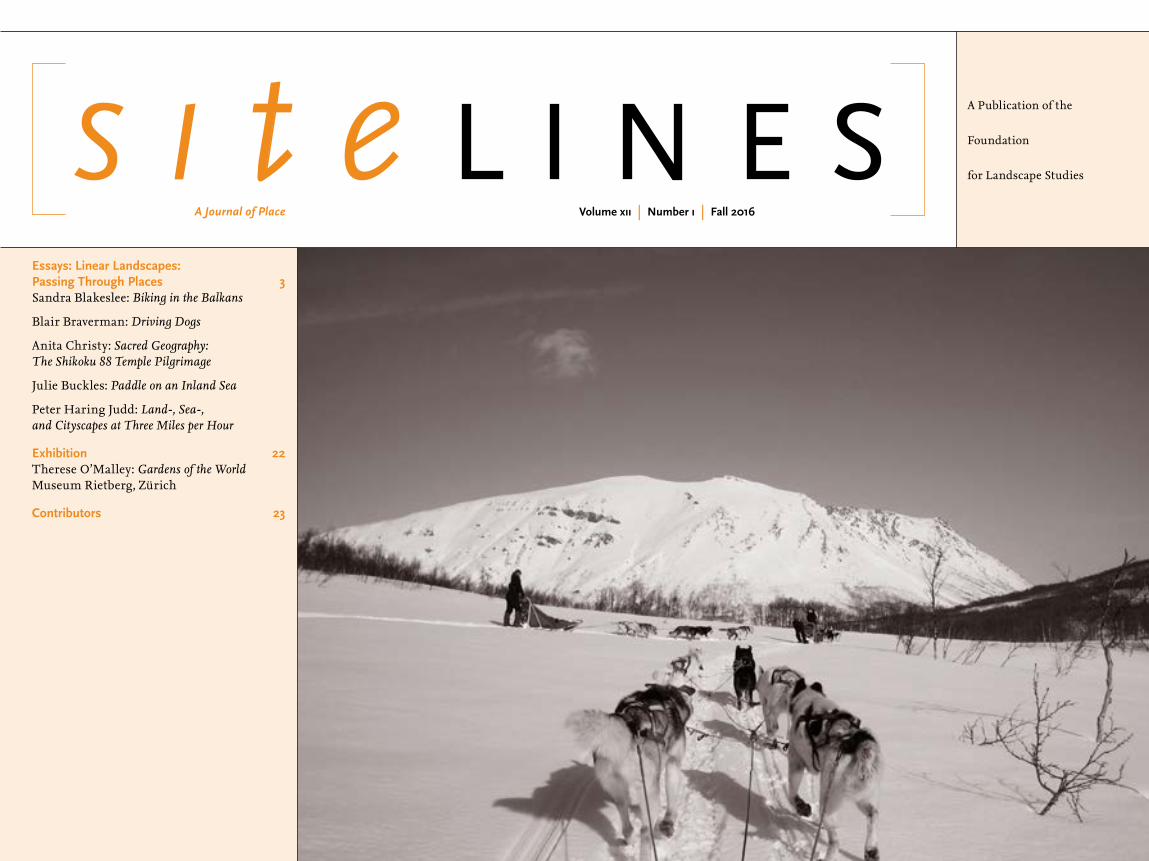
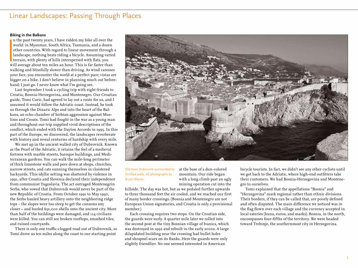
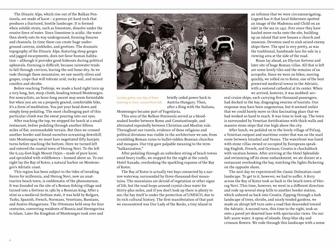

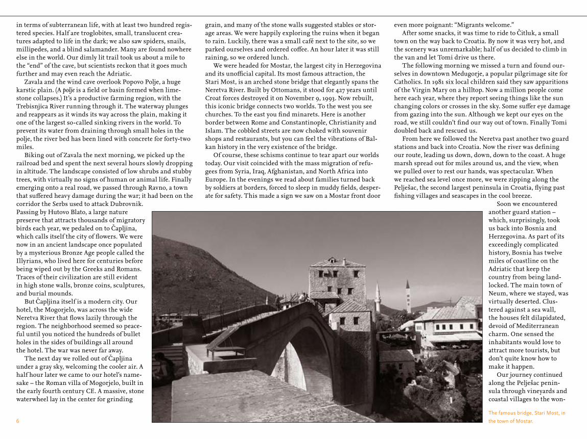

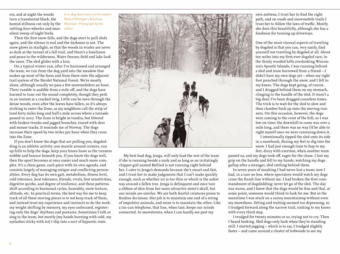
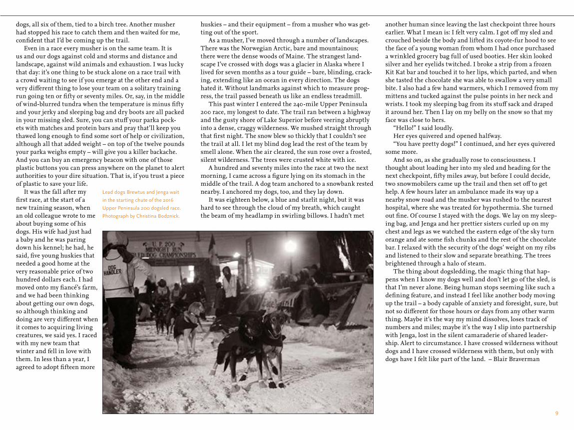


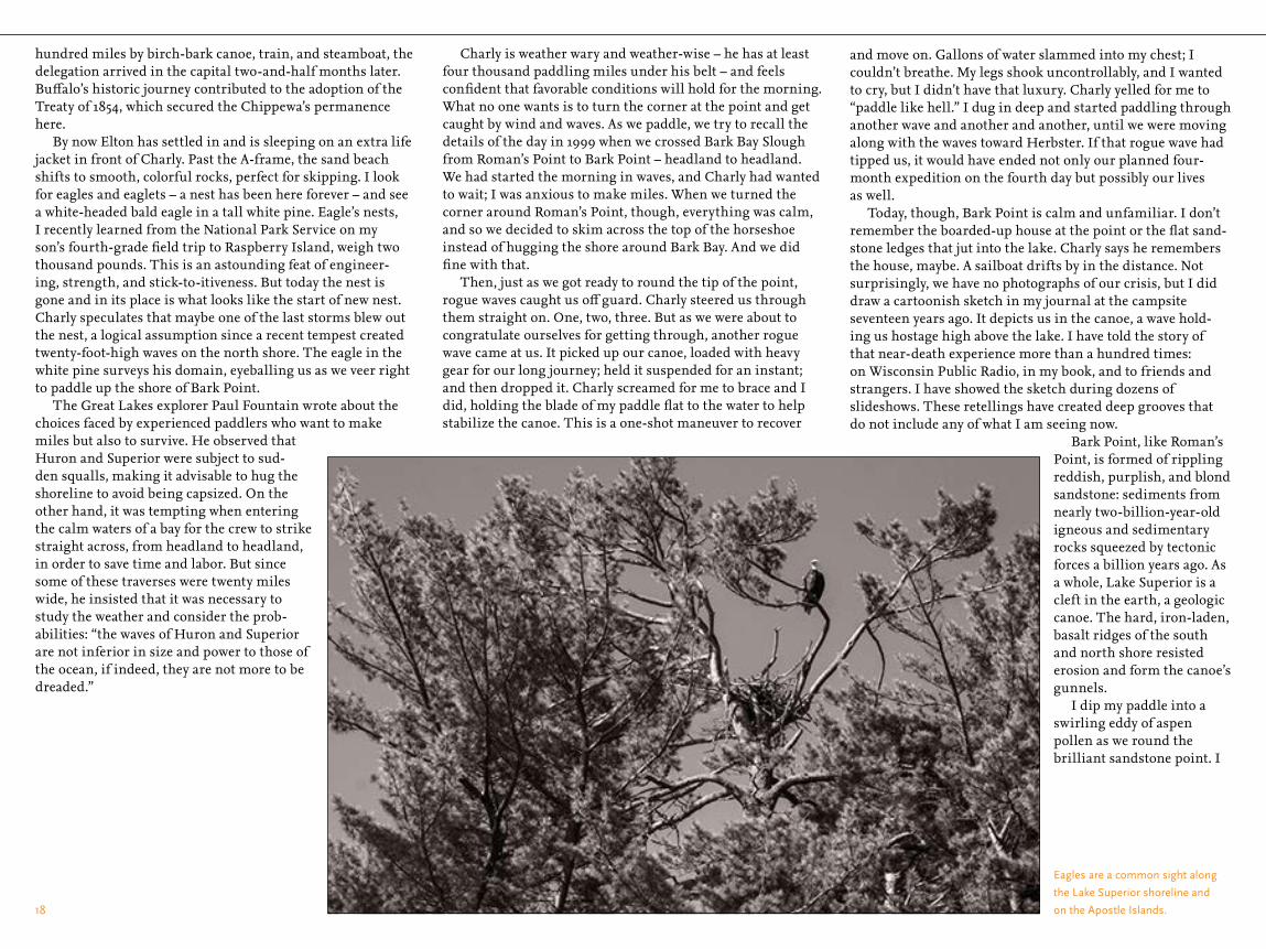


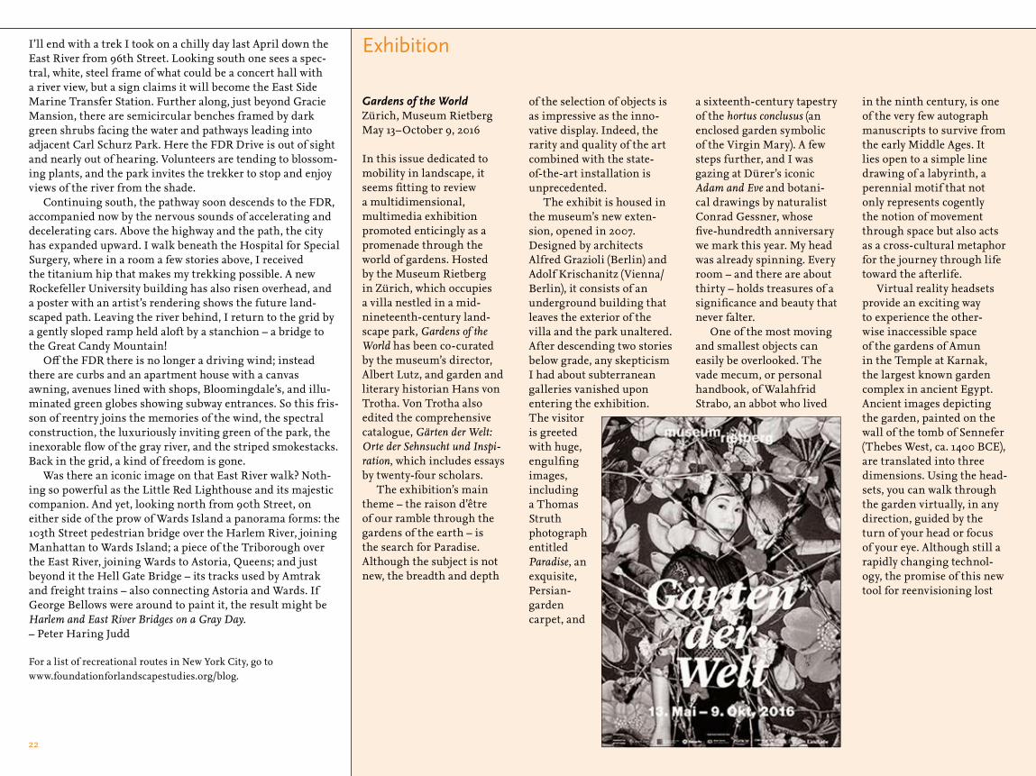


![µoıµ„o˚’ U „¡’ }’ „‰µ]ı˚ ı v] }’ ˚vı„˚ KªÙ˚ݪ°ªç ... · 2019. 2. 27. · µoıµ„o˚’ U „¡’ }’ ˙ „‰µ]ı˚ ı v] }’ ˚vı„˚](https://static.documents.pub/doc/80x56/6148f9779241b00fbd674270/oaoa-u-aa-a-aa-v-a-va-k.jpg)


