18
SEPTEMBER 2014 A & M SMITH SKIP HIRE LIMITED Bankhead Recycling and Resource Centre Development, Portlethen Environmental statement (Volume 3) Non-technical summary 190369
SEPTEMBER 2014
A & M SMITH SKIP HIRE LIMITED
Bankhead Recycling and Resource Centre Development, Portlethen
Environmental statement (Volume 3) Non-technical summary
190369
Bankhead Development, Environmental Statement: Non-technical summary i
Contents
INTRODUCTION ..................................................................................................................................... 1
The project team ............................................................................................................................. 1
SITE DESCRIPTION ............................................................................................................................... 1
Site and its surroundings .................................................................................................................. 2
CONSULTATION .................................................................................................................................... 2
NEED FOR THE DEVELOPMENT ......................................................................................................... 3
PROJECT DESCRIPTION ...................................................................................................................... 4
Project alternatives ....................................................................................................................... 5
APPROACH TO THE EIA ...................................................................................................................... 7
EIA ISSUES AND FINDINGS ............................................................................................................... 10
Construction and environmental management ........................................................................... 10
Physical Environment ................................................................................................................. 10
Hydrology and drainage.............................................................................................................. 11
Cultural Heritage ......................................................................................................................... 11
Ecology .................................................................................................................................... 11
Noise and vibration ..................................................................................................................... 12
Transport and access ................................................................................................................. 12
Waste management .................................................................................................................... 13
Cumulative impacts .................................................................................................................... 13
WHAT HAPPENS NEXT? .................................................................................................................... 14
CONTACT DETAILS ............................................................................................................................ 14
FIGURES
Figure 1: Site location..……………………………………..…………………………………....15
Figure 2: Site layout......…………………………………..……...……………………………....16
Bankhead Development, Environmental Statement: Non-technical summary 1
INTRODUCTION
This is the non-technical summary (NTS) of the
environmental statement (ES) for the Bankhead
Development, near Portlethen, Aberdeenshire. It
describes in non-technical language the proposed
development (see Box 1) and the potential impacts
it may have on the physical and biological
environment and on people. It also lists the
measures that the developer will implement to
avoid or reduce adverse impacts, and describes
how environmental issues will be managed during
and after construction.
The ES presents the complete findings of the
environmental impact assessment (EIA), and is one
of the documents accompanying the outline
planning application submitted under the Town and
Country Planning (Scotland) Act 1997. The primary
purpose of the ES is to inform the planning and
decision making process by reporting the results of
the EIA, and in particular identifying any significant
environmental effects. The authority determining
the application is Aberdeenshire Council. They have
confirmed that the development requires an ES to
be submitted alongside the planning application.
If you have any questions or would like to
comment on the application then you can find out
how to do so at the end of this NTS.
The project team
The site developer is A&M Smith Skip Hire Ltd. The
Project Team working on behalf of the developer
on planning, design and environmental issues
included:
• Cameron and Ross who are the Engineers for
the scheme
• Cumming & Co, architects who prepared the
masterplan for the site and accompanying
illustrative drawings of the proposed
development
• RSK Environment Limited (RSK) who undertook
the EIA and prepared the environmental
statement.
RSK was responsible for undertaking and managing
the EIA studies, using their in-house resources
supplemented by the following specialist
consultants:
• Mott MacDonald Ltd for the transport
assessment
• Cameron & Ross Ltd for all engineering and
design issues including site drainage and
hydrology assessment.
Box 1: Overview of Proposed Development
The proposed development is on around 15.5 ha of land, of which approximately 8.5 hectares is currently
operational as a skip hire business and active waste management facility, consisting of a non-hazardous
solid waste transfer station and inert landfill operations. The landfill has been in operation since 1974 and
is currently licensed to dispose of 25,000 tonnes of inert wastes every year. The waste transfer station has
been operational since 1998 and is licensed to handle 75,000 tonnes per annum (tpa).
The site is allocated in the 2012 Aberdeenshire Local Development Plan for employment uses and an area
of search for waste facilities and associated uses. The applicant is seeking to secure full planning
permission for Phase 1 and 2 of the proposed scheme, as well as outline planning permission ‘in principle’
for Phase 3 of the proposed scheme.
At completion of Phase 2 the site will handle up to 107,000 tpa comprising approximately (subject to
demand and licencing restrictions, if any, to be agreed) 46,000 tpa non-hazardous wastes, 32,000 tpa inert
wastes, 21,000 tpa timber wastes, and 8,000 tpa green waste
Environmental factors were considered from the earliest stage of the proposals and so the engineering
design and layout has been developed in response to awareness of the environmental issues of the area.
The layout plan already incorporates a number of measures designed to avoid or reduce environmental
impacts.
Bankhead Development, Environmental Statement: Non-technical summary 2
SITE DESCRIPTION
Site and its surroundings
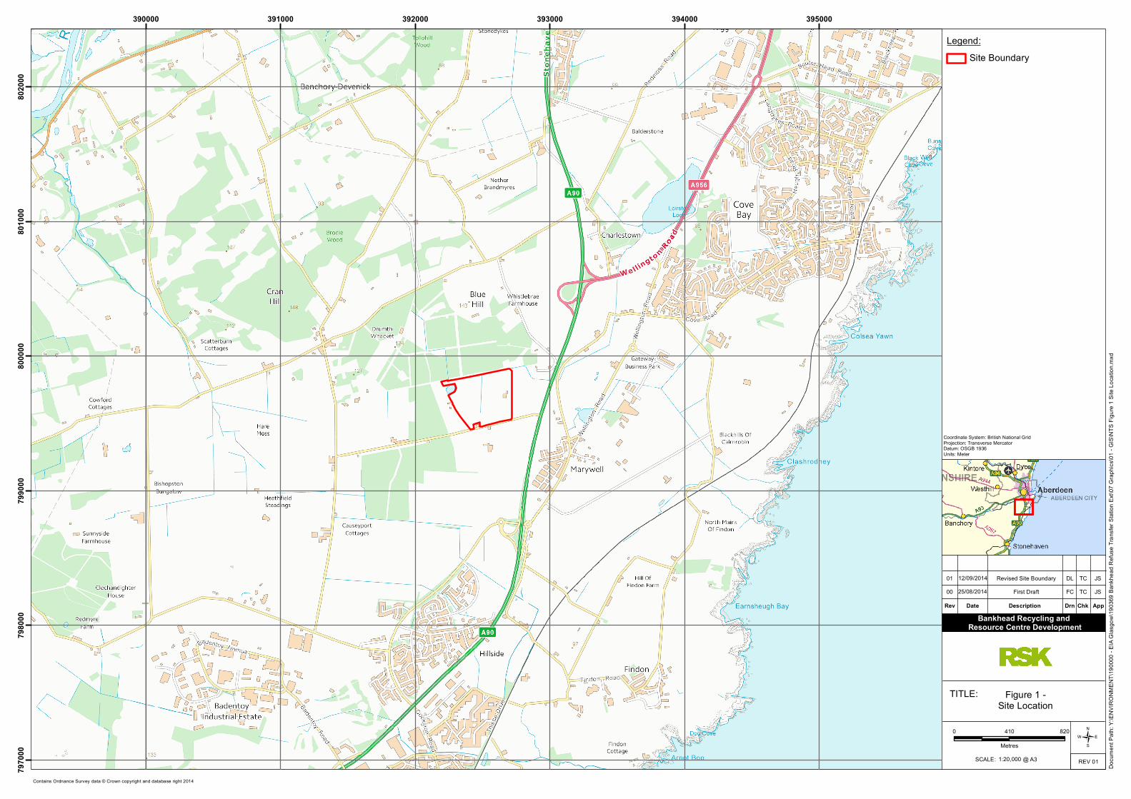
The site is located to the north west of Portlethen
in a predominantly rural area. The land is bounded
by forestry to the north (separated from the site
by a small watercourse running along the northern
edge of the site boundary) and agricultural fields
to the south and west. To the east is a former pipe
storage yard and beyond that the A90, which is a
dual carriageway that provides access to the city of
Aberdeen. There are agricultural fields used for
cattle grazing and silage within the site as well as
an open water pond in the north-western corner.
A small watercourse runs through the middle of
the western half of the site.
The main site access is off Duffshill Road (U58K) to
the south, which provides existing access to the
northbound and southbound A90. The site is
located in close proximity to the route of the
recently approved Aberdeen Western Peripheral
Route (AWPR), which is being developed to
improve travel in and around Aberdeen and the
north east of Scotland. The AWPR will run close to
the north eastern and western boundaries of the
site.
There are four residential properties located
nearby, with two located off Duffshill Road close to
the southern boundary of the site (Balmoss and
Fair View), and two located off the access track
which forms the western boundary (Turnamiddle
House and Turnamiddle Cottage). A location plan
is provided in Figure 1.
The existing waste management facilities are
located on about 8.5 ha of the site and the
remaining 7 ha of land in the western part of the
site consists of either agricultural fields that have
not been subject to any development, or land that
has been raised over the last ten years with inert
soils from the waste transfer station activities,
under licensed exemption.
The site is not located in an environmentally
sensitive area and there are no recorded breaches
of environmental standards (nitrogen dioxide and
particulate pollution concentrations are well
within the applicable air quality standards). In
addition, there is no ecological, landscape,
recreation or cultural heritage designation on or in
close proximity to the site.
CONSULTATION
Pre-application discussions with Aberdeenshire
Council and various statutory consultees have
taken place in tandem with design of the proposed
development.
An EIA screening and scoping opinion was received
from Aberdeenshire Council (including comments
from the Major Applications Unit and SEPA) on
29th
April 2013. A project Scoping Meeting was
held with the Council on 31st
October 2013 to
agree the scope of the EIA and the planning
application process.
A subsequent planning application for 3m high
landscaped bunds surrounding the entire site was
approved and so a case was made to the Council
on 29th
April 2014 that a landscape and visual
assessment of the proposed development was no
longer necessary. The Council subsequently agreed
that such an assessment would not be required
and could be scoped out. The applicant’s team also
considered that due to the absence of any surface
peat/ wetland areas and the patchy occurrence of
buried peat across the site (as evidenced from
previous site investigations), there would be no
need for a peat assessment. However, SEPA
responded on 24th
June 2014 maintaining that
peat should be considered in the EIA. Accordingly,
the subsequent EIA has addressed all the issues
raised in the scoping opinion, subsequent
correspondence and meetings, apart from
landscape assessment.
The following departments in Aberdeenshire
Council were consulted:
Bankhead Development, Environmental Statement: Non-technical summary 3
• Planning
• Infrastructure Services (Roads,
Contaminated Land, Environment Team,
Flood Prevention Unit, Waste
Management, and Environmental Health
Input was also sought from the following:
• SEPA
• SNH
• Historic Scotland
• Community Councils
• Transport Scotland
In accordance with Regulations, a Proposal of
Application Notice (PAN) was issued to
Aberdeenshire Council on 4th March 2014 and
public consultation took place during February and
March 2014. The consultation has been
summarised in the Pre-application Consultation
Report.
In addition to the formal EIA process, other
correspondence and discussions took place with a
range of organisations including local landowners,
utilities and transport companies, and local
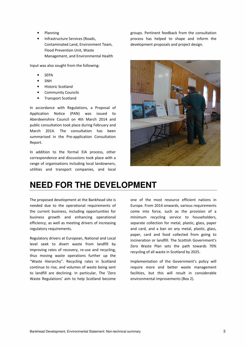
groups. Pertinent feedback from the consultation
process has helped to shape and inform the
development proposals and project design.
NEED FOR THE DEVELOPMENT
The proposed development at the Bankhead site is
needed due to the operational requirements of
the current business, including opportunities for
business growth and enhancing operational
efficiency, as well as meeting drivers of increasing
regulatory requirements.
Regulatory drivers at European, National and Local
level seek to divert waste from landfill by
improving rates of recovery, re-use and recycling,
thus moving waste operations further up the
“Waste Hierarchy”. Recycling rates in Scotland
continue to rise, and volumes of waste being sent
to landfill are declining. In particular, The ‘Zero
Waste Regulations’ aim to help Scotland become
one of the most resource efficient nations in
Europe. From 2014 onwards, various requirements
come into force, such as the provision of a
minimum recycling service to householders,
separate collection for metal, plastic, glass, paper
and card, and a ban on any metal, plastic, glass,
paper, card and food collected from going to
incineration or landfill. The Scottish Government's
Zero Waste Plan sets the path towards 70%
recycling of all waste in Scotland by 2025.
Implementation of the Government’s policy will
require more and better waste management
facilities, but this will result in considerable
environmental improvements (Box 2).
Bankhead Development, Environmental Statement: Non-technical summary 4
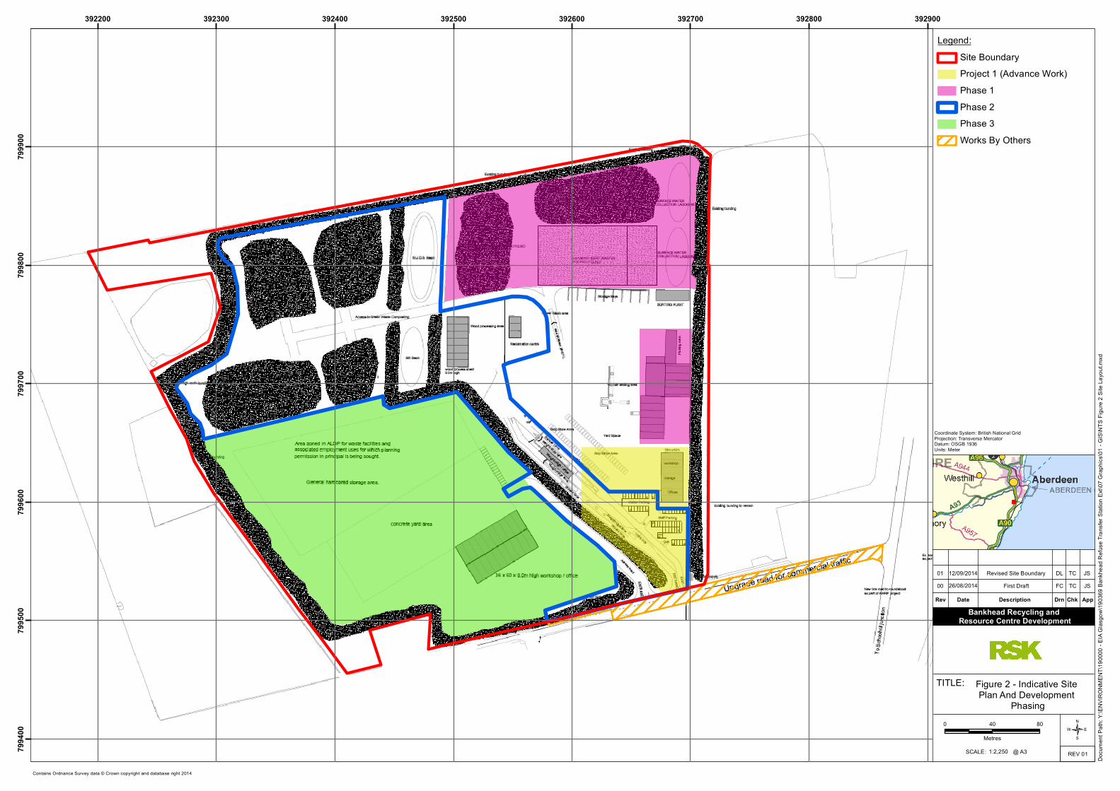
PROJECT DESCRIPTION
The proposed site layout plan, which shows the
main development areas (and indicative phasing)
and infrastructure such as buildings, weighbridges,
roads and access, is shown in Figure 2. This Figure
also shows the area subject to the planning
application (the site ‘redline’), which encloses an
area of about 15.5 hectares.
The site development (Box 3) would be
constructed in three distinct phases in order to
limit detriment to surrounding neighbours and to
minimize disruption to the current site operations.
Phases 1 and 2 comprise the detailed planning
application. The area covered by the proposed
Phase 3 development is subject to a “planning
application in principle”.
Work to construct a 3m high perimeter bund that
will enclose the entire site area is already
underway under an existing planning permission. A
separate planning application has also been
submitted for the construction of a workshop with
washbay, garage and office accommodation and
electricity substation, formation of a car park and
access road and formation of an internal bund
(that will separate access to the future Phase 1/2
and the Phase 3 area to be operated by others).
Phase 1
Phase 1 of the development will be built in the
north-east part of the site and will comprise
extensions to the existing transfer station shed, a
soils/aggregate washing plant, a concrete batching
plant, processed materials stockpiling areas and a
sustainable drainage system (SuDS) providing 3
levels of treatment in 2 settlement lagoons. The
main components are summarised in Box 3 below.
Phase 2
This phase will be developed following completion
of the new Aberdeen Western Peripheral Road /
A90 link. Bunds separating Phase 1/2 and future
Phase 3 areas will be completed, allowing
construction of two access roads into each part of
the site. In Phase 2 there will be a new double
weighbridge and associated admin buildings,
additional staff and visitor car parking and an
additional area of hardstanding for skip storage.
Box 2: Main benefits of the development
• Contributing to Scotland’s aim to be one of the most resource efficient nations in Europe, and
meeting the long term target of recycling 70% of all Scotland’s waste requiring that waste is
sorted into separate streams for recycling and reprocessing, leaving only limited amounts for
residual waste treatment
• Providing a modern waste management facility, meeting increasingly stringent regulatory
standards, which is located close to the sources of waste and with good transport connections, at
a previously developed site
• Reduce environmental impacts, improve site safety, improve operational controls and resource
efficiency (to maximise recycling and minimise residual wastes to landfill)
• Carry out on-site servicing and repairs on the A & M Smith fleet rather than at other locations
out-with the site and to maintain skips and recycling equipment on-site, so minimising traffic
movements in and out of the site
• Construction of a new access road entrance into the site for improved safety and efficiency
• End the inert waste landfill operation by replacing it with a soil and aggregates washing plant
• Install a concrete batching unit to utilise sands and aggregates produced by the washing of
incoming waste soils. The concrete will initially be used for construction projects within the site
• Provide further opportunities for other waste management businesses in the future Phase 3
development of the site, providing business synergies.
Bankhead Development, Environmental Statement: Non-technical summary 5
Once the new access is operational the existing
access will be removed to allow additional areas of
existing inert landfill to be remediated on-site to
prepare for future development.
A new wood processing shed and reclamation
centre (for storage) will be constructed; it is
anticipated that any buildings constructed on the
site would be steel framed storage sheds, and
would have a maximum height of twelve metres.
The wood processing shed will house equipment
for shredding/ chipping and screening, plus a
loading excavator.
A large area at the northwest part of the site will
be developed (in stages to meet demand) as a
green waste composting facility and would
comprise up to four open composting areas with
windrows formed up to 3 m high (dust suppression
provided as necessary using a water bowser and
sprayer).
Phase 2 (and Phase 3) will likely create additional
foul sewage flow on the new site. It is therefore
proposed to construct new foul drainage to
connect to the Scottish Water foul sewer system.
Phase 3
The large area at the southwest part of the site will
be subject to future development by others and so
permission ‘in principle’ is sought at this stage for
future employment and waste facility uses. Future
detailed planning applications will come forward in
due course for any proposed development.
It is likely that the equipment and buildings/
structures in Phase 3 would be of similar
dimensions and types as that proposed in Phases 1
and 2, i.e. an overall building height of less than
12m. For illustrative purposes the indicative layout
plan shows a workshop/ office block of dimensions
36m x 60m x 8m high with associated parking
spaces, along with an open surfaced (hardcore)
storage area and a concrete yard area. Only the
access road and hardstanding areas will be
prepared by the current applicant.
Construction approach
Construction works will follow a standard
sequence including the following:
• advance works including topographical,
geotechnical and other surveys
• phased remediation of areas of the site
that have previously been subject to inert
landfill activities, programmed to
commence following the installation,
licensing and commissioning of the soils
washing plant
• establishment of temporary construction
compounds within the site area
• preparatory earthworks and site levelling
as necessary (all material to be retained
on site, for instance in formation of the
earth bunds and localised fill where
suitable)
• concrete formation works by an
appointed contractor
• building foundation works (likely strip or
pad foundations) and building
construction by an appointed contractor
• delivery and installation of plant and
other equipment by the supplier[s]
It is anticipated that construction work will take
place from 7 AM to 6 PM seven days a week
excluding Public Holidays. The existing 24-hour site
security lighting and CCTV would be sufficient and
no additional measures are envisaged to be
necessary.
It is anticipated that up to ten temporary
construction site jobs could be created during
Phase 1 for local contractors and up to 15
temporary jobs in Phase 2. It is expected that up to
13 additional full time jobs could be provided for
site operations and administration personnel.
Project alternatives
The main alternatives include:
• Develop an alternative site
• Use different technology
• Adopt different site layout
• Do nothing
The option not to develop the site (thus to
maintain the status quo by retaining the existing
business at the currently operating site, and to
retain the additional land in agricultural use), is not
preferred for several reasons:
Bankhead Development, Environmental Statement: Non-technical summary 6
• opportunity cost to the business unable
to meet the increasing demands of its
customers
• the need to develop similar facilities at
additional sites to meet demand, perhaps
entailing increased transport distance,
emissions and costs
• inability to fully introduce operational
efficiencies at the existing site
• difficulty in meeting potential changes in
waste planning policy requirements and
tightening environmental legislation
• compromise in the ability to reduce the
amount of waste material disposed to
landfill, at considerable cost and with
adverse environmental implications,
particularly on available landfill capacity
• less ability to resell increased amounts of
recyclable material to the market.
Other sites were not considered for development
because of the additional time, cost, and
uncertainty this would entail. The existing site,
under ownership of the applicant, is allocated in
the 2012 Aberdeenshire Local Development Plan
for employment uses and as an area of search for
waste facilities and associated uses. The site is
considered to be suitable for the development of a
recycling and resource centre development.
The initial design was to access the site using only
one main access road and weighbridge but it was
deemed too restrictive on potential users of the
Phase 3 development land. Therefore it was
determined that construction of an additional
access serving only the Phase 3 area would be
required. No other designs were considered,
although careful thought has been given to the site
layout to maximise site operational efficiency.
Providing two access points will help reduce traffic
congestion and queuing. Allowing modular and
staged build-out of the development to meet
future demand provides flexibility. Opportunities
have been taken to enclose previously open air
activities, with both business and environmental
benefits.
Alternative waste treatment technologies such as
anaerobic digestion were considered but rejected
and it is considered that the resulting proposed
development provides a good, environmentally
acceptable solution for the site. Treatment
technology including SuDS has been adopted to
maximise opportunity for recycling drainage water
for use on site (in composting areas and dust
suppression).
Bankhead Development, Environmental Statement: Non-technical summary 7
APPROACH TO THE EIA
Environmental impact assessment (EIA) is a
systematic process to identify, predict and
evaluate the environmental effects of proposed
projects.
The authority determining the planning
application1 has confirmed that the development
1 Planning application submitted to Aberdeenshire Council
under the Town and Country Planning (Scotland) Act 1997
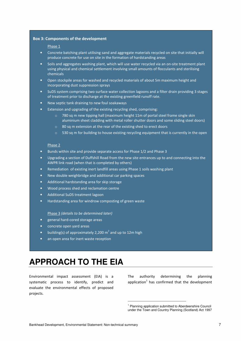
Box 3: Components of the development
Phase 1
• Concrete batching plant utilising sand and aggregate materials recycled on site that initially will
produce concrete for use on site in the formation of hardstanding areas
• Soils and aggregates washing plant, which will use water recycled via an on-site treatment plant
using physical and chemical settlement involving small amounts of flocculants and sterilising
chemicals
• Open stockpile areas for washed and recycled materials of about 5m maximum height and
incorporating dust suppression sprays
• SuDS system comprising two surface water collection lagoons and a filter drain providing 3 stages
of treatment prior to discharge at the existing greenfield runoff rate.
• New septic tank draining to new foul soakaways
• Extension and upgrading of the existing recycling shed, comprising:
o 780 sq m new tipping hall (maximum height 11m of portal steel frame single skin
aluminium sheet cladding with metal roller shutter doors and some sliding steel doors)
o 80 sq m extension at the rear of the existing shed to erect doors
o 530 sq m for building to house existing recycling equipment that is currently in the open
Phase 2
• Bunds within site and provide separate access for Phase 1/2 and Phase 3
• Upgrading a section of Duffshill Road from the new site entrances up to and connecting into the
AWPR link road (when that is completed by others)
• Remediation of existing inert landfill areas using Phase 1 soils washing plant
• New double weighbridge and additional car parking spaces
• Additional hardstanding area for skip storage
• Wood process shed and reclamation centre
• Additional SuDS treatment lagoon
• Hardstanding area for windrow composting of green waste
Phase 3 (details to be determined later)
• general hard-cored storage areas
• concrete open yard areas
• building(s) of approximately 2,200 m2 and up to 12m high
• an open area for inert waste reception
Bankhead Development, Environmental Statement: Non-technical summary 8
requires submission of an environmental
statement2. The purpose of the EIA is to:
• Provide a baseline against which actual
project impacts will be assessed
• Identify and assess the anticipated
negative and positive environmental and
social impacts of projects
• Determine measures designed to avoid,
minimise or mitigate negative
environmental or social impacts and
optimise potential positive impacts
• Use the results of that assessment to
inform option selection and subsequent
project design
• Consult with and obtain feedback from
project stakeholders.
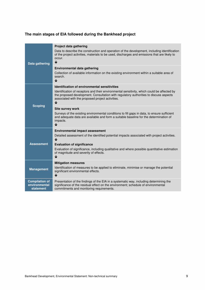
The main stages of the EIA that were followed are
illustrated on the following page. This is only
indicative since the actual process is highly
iterative and includes additional steps such as
stakeholder interaction, which is not shown.
Baseline environmental conditions were identified
from a range of sources and field surveys as
identified in Box 4.
The scheme master plan was developed iteratively
to allow incorporation of knowledge of site
constraints gained from the baseline evaluations
and to allow impact avoidance and mitigation
measures to be ‘designed-in’.
2 The project falls under Schedule 2 of the Town and
Country Planning (Environmental Impact Assessment) (Scotland) Regulations 2011.
Box 4: Environmental baseline surveys
• Phase 1 ecological surveys of site
• Botanical (plants and flowers) surveys
• Mammal surveys (bats, badger, water
vole)
• Breeding bird surveys
• Reptile surveys (snakes and lizards)
• Survey of Great Crested Newt habitat
potential
• Baseline noise monitoring
• Targeted ground investigations
• Site walkovers to confirm:
o Existing operations at site
including waste types and
volumes handled and any existing
issues
o Cultural heritage remains
o Physical conditions including
landforms, ground conditions,
and hydrology
o Existing traffic flows
Bankhead Development, Environmental Statement: Non-technical summary 9
The main stages of EIA followed during the Bankhead project
Data gathering
Project data gathering
Data to describe the construction and operation of the development, including identification of the project activities, materials to be used, discharges and emissions that are likely to occur.
�
Environmental data gathering
Collection of available information on the existing environment within a suitable area of search.
�
Scoping
Identification of environmental sensitivities
Identification of receptors and their environmental sensitivity, which could be affected by the proposed development. Consultation with regulatory authorities to discuss aspects associated with the proposed project activities.
�
Site survey work
Surveys of the existing environmental conditions to fill gaps in data, to ensure sufficient and adequate data are available and form a suitable baseline for the determination of impacts.
�
Assessment
Environmental impact assessment
Detailed assessment of the identified potential impacts associated with project activities.
�
Evaluation of significance
Evaluation of significance, including qualitative and where possible quantitative estimation of magnitude and severity of effects.
�
Management
Mitigation measures
Identification of measures to be applied to eliminate, minimise or manage the potential significant environmental effects.
�
Compilation of environmental
statement
Presentation of the findings of the EIA in a systematic way, including determining the significance of the residual effect on the environment; schedule of environmental commitments and monitoring requirements.
Bankhead Development, Environmental Statement: Non-technical summary 10
EIA ISSUES AND FINDINGS
Construction and environmental
management
A construction environmental management plan,
including various other plans as identified below,
would be prepared in advance of starting
construction work at site. The plan would include
specific measures designed to reduce and control
the occurrence of potentially adverse impacts,
including control of pollution risk. Good site
practices would be adopted to ensure that
environmental conditions at sensitive receptors
would not be unacceptable.
Physical environment
Data on ground conditions, including geology,
soils, surface and ground water was collected from
existing documented information, as well as
targeted ground investigation at the site
(boreholes and trial trenches).
Considering the construction phase activities it
was concluded that the potential health risks to
construction workers, and pollution risk to surface
and groundwater quality from mobilisation of
contaminants in existing made ground and soils
would be no more than minor (hence
insignificant). There is no surface peat and isolated
lenses of relict peat horizons at depth, if
excavated, would be unlikely to result in significant
risk to climate from carbon release.
Considering the operation phase activities on site,
it was concluded that there would be negligible
effects on geology (no deep excavations or piling
would take place). There would also be no more
than minor risk of fuel or chemical spillages
impacting surface of ground waters. Furthermore,
the increased extent of impermeable surface hard
standing across the site would result in only a
minor effect on groundwater recharge (refilling of
the underground water supply from rainfall
percolating through the surface ground layer).
Various mitigation measures will be implemented
such as:
• An asbestos management plan in case
buried asbestos is encountered in
previous filled ground
• Pre-construction risk assessment for
protection of the workforce from health
risk posed by any foreseen contamination
• Adoption of a range of standard ‘good
practice’ measures for control of pollution
at the construction site and during site
operations, particularly to avoid pollution
from fuel and chemical leaks from
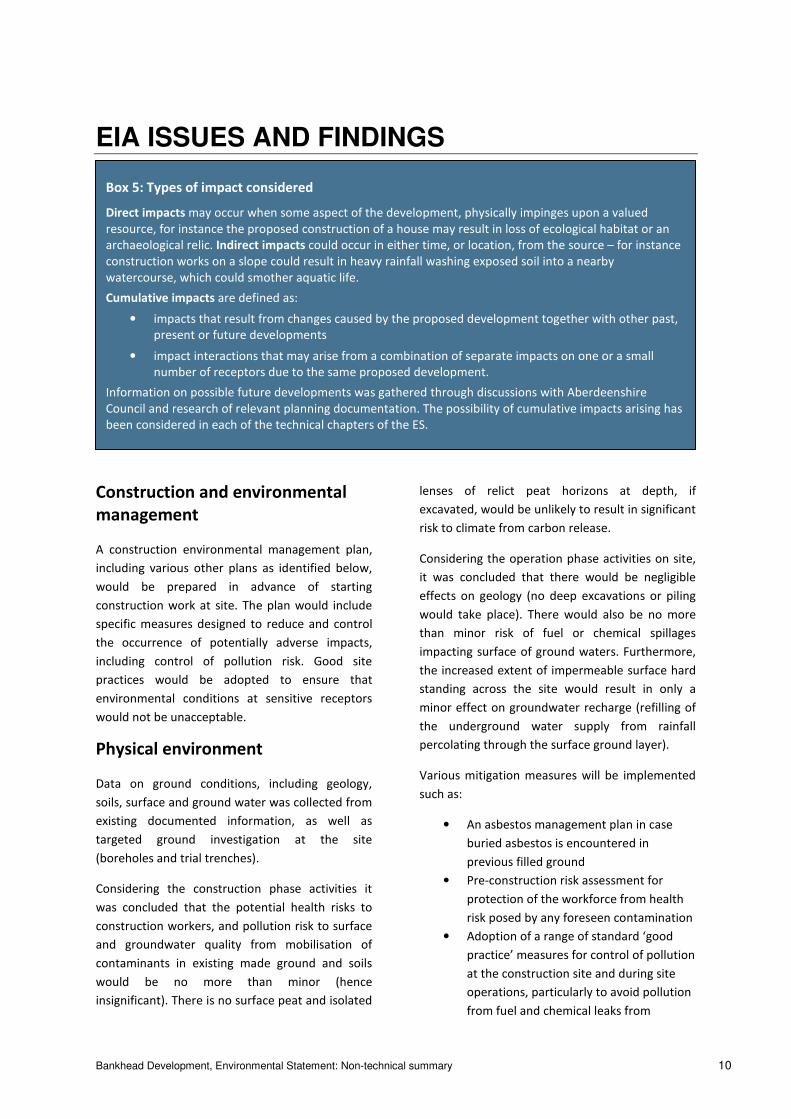
Box 5: Types of impact considered
Direct impacts may occur when some aspect of the development, physically impinges upon a valued
resource, for instance the proposed construction of a house may result in loss of ecological habitat or an
archaeological relic. Indirect impacts could occur in either time, or location, from the source – for instance
construction works on a slope could result in heavy rainfall washing exposed soil into a nearby
watercourse, which could smother aquatic life.
Cumulative impacts are defined as:
• impacts that result from changes caused by the proposed development together with other past,
present or future developments
• impact interactions that may arise from a combination of separate impacts on one or a small
number of receptors due to the same proposed development.
Information on possible future developments was gathered through discussions with Aberdeenshire
Council and research of relevant planning documentation. The possibility of cumulative impacts arising has
been considered in each of the technical chapters of the ES.

Bankhead Development, Environmental Statement: Non-technical summary 11
equipment and vehicles operating on site
and from use of concrete products
• A site waste management plan
documenting procedures for waste
handling (segregation and temporary
storage) treatment and disposal,
particularly for remediation of wastes and
reuse on site
• Provision of bunds as necessary to protect
surface waterbodies from contaminated
site runoff, plus storage of polluting
materials (if any) in suitable bunded
storage areas.
Hydrology and drainage
The site generally slopes from southwest to
northeast. There is an existing drain running from
south to north through the site, which connects to
the Drumth Whackett burn running from west to
east along the northern boundary of the site. The
existing site drainage would be culverted. Review
of the SEPA maps shows the site is not at risk of
flooding.
Foul sewage would flow to an existing septic tank
and soakaways adequately sized for Phases 1 and
2 of the proposed development. Site tests have
confirmed that soakaways would be acceptable.
Increased staff numbers anticipated during Phase
3 would necessitate connection to the public
sewer, which it is anticipated would be extended
to (or close to) the site during works for the
AWPR/ link Road and proposed park and ride, so
future connection is anticipated to be possible.
Surface water is currently drained to ground. A
sustainable drainage scheme (SuDS) will be
constructed in Phase 1, providing 3 stages of
treatment. The SuDS will be designed to meet
appropriate standards and will be expanded in
Phase 2, to a size sufficient to accept flows from
the Phase 3 area and adequate to achieve a
discharge rate no more than the existing
‘greenfield’ rate (i.e. no additional discharge
volume above existing flows).
Cultural heritage
Information on cultural heritage resources, both
above and below ground, on the site and in the
surrounding area was collected from available
records and was confirmed by a site visit.
One non-designated site, considered to be of low
importance, was identified within the Phase 2
construction works area (possible remains of a
building demolished prior to 1888). The
significance of effect from the proposed
development would be slight. No further work is
necessary for this site.
No impacts on the setting of the one designated
cultural heritage receptor within 2km of the
construction works area were identified.
All three phases of the construction works will
disturb or damage buried peat deposits that may
contain waterlogged organic environmental
evidence of climate, land use and land use change
during the prehistoric period. Mitigation measures
have been proposed to address any direct impacts
on known or unknown, buried archaeology.
Following implementation of a mitigation
programme agreed with Aberdeenshire Council
Archaeology Service, physical archaeological
impacts within the footprint of the Development
would be fully neutralised for all three phases of
construction.
During the operational phases of the Development
there would be no impacts on any heritage assets.
Ecology
A Background Data Search of the site and vicinity
to obtain archived biological records from a range
of sources was undertaken, in addition to a range
of field surveys.
The surveys found a range of habitats on site
although no wetlands were present, having
probably been previously lost through historic land
use changes. No species of importance (either
plants or animals) were found and generally
conditions were found to be unsuitable. Surveys
considered the potential for legally protected
species and reported the following:
Bankhead Development, Environmental Statement: Non-technical summary 12
• No evidence of bat roosts although areas
around the site may be used for foraging
• No evidence for breeding/ nesting birds
although some habitat within the site
could be suitable
• Unsuitable conditions for badger setts or
foraging
• Existing nearby water bodies were found
to be unsuitable for Great Crested Newts
and there are no records of their
presence in the area
• No evidence or records of otters using the
streams
• Generally unsuitable conditions for
reptiles and no records of their presence
• No suitable habitat for water voles and no
records of their presence.
Measures were recommended to control the
spread of Japanese Knotweed (an invasive species)
during construction and to ensure that any site
lighting does not affect the potential of
surrounding areas to be used by bats for foraging.
Precautionary measures would be adopted as
necessary in case there happen to be any nesting
birds on site during construction.
In general it is expected that vegetation cover on
the bunds surrounding the site may increase insect
abundance and thereby have positive benefits for
bats and birds.
Noise and vibration
Noise monitoring at a nearby residence
characterised the typical existing noise
background. Predictions of the future noise
environment were made in respect of construction
work, traffic noise, and noise from various
operating plant/ equipment. Generally noise has
been predicted at the nearest residence to the
works with noise emission points located at the
nearest point of each area of works, representing a
worst case situation.
Predicted construction noise levels would be
below the applicable threshold level for daytime of
65 dB(A) but would be noticeable. Construction
traffic would not contribute noticeably to these
noise levels. The construction noise levels would
not be significant.
The noisiest operating plant at the site is likely to
be the soils washing plant and the concrete
batching plant. Noise level predictions indicate an
increase by up to 8 dB(A) at nearby residences
which although relatively minor, would be
noticeable and could generate complaints and so
is considered of moderate significance. It is
expected that noise screening could be provided
to reduce the predicted noise to an acceptable
level. A delivery management plan would also be
developed to control noise from arriving waste
loads. Additional noise from the wood shredder
operating in Phase 2 would not increase the noise
levels due to the distance from residences. Traffic
noise would not be significant in Phase 1 and
traffic noise level would only increase by around
1% during Phase 2, which is not significant.
Phase 3 development would have the potential to
result in higher overall noise levels and so future
consideration should be given to plant type,
location and the need (if any) for additional noise
screening when this development comes forward.
Transport and access
Information on existing traffic levels was gathered
from existing data provided by the Council and the
site operator. This was compared with the
estimated increase in traffic levels during
construction and operation of each Phase of
development. The proposed upgrading of Duffshill
Road and provision of the new site access roads, as
well as the future connection to the proposed
AWPR was taken into account.
Additional traffic will be generated during the
construction of Phase 1, however the estimated
level of traffic will not cause significant impacts.
The operation of Phase 1 is not expected to
generate any additional traffic and hence no
significant impacts are expected.
The construction of Phase 2 will generate
additional traffic, but this is not considered to be
significant. The operation of Phase 2 is expected
to result in around a 20% increase in traffic to and
from the proposed development, but this is not
Bankhead Development, Environmental Statement: Non-technical summary 13
considered to cause a significant effect as it is
below thresholds established in the ‘Guidelines for
the Environmental Assessment of Road Traffic’
published by the Institute for Environmental
Management and Assessment.
Two new accesses will be provided onto Duffshill
Road as part of the proposed development, one of
which will replace the existing access. These new
accesses will be constructed to appropriate design
standards. Duffshill Road will also be widened
from the site to its junction with the new link road
serving to access the AWPR. This widening will
allow two-opposing direction vehicles to pass,
which is an improvement over the existing
situation where two-way flow is not possible
except at a passing space.
The construction of Phase 3 will also generate
additional traffic, but again this is not considered
to be significant. The operation of Phase 3 is
expected to result in around a 62% increase in
traffic but this increase in traffic is not considered
to cause any significant transport-related effects as
it is only around a 300m long section of the
improved Duffshill Road which will experience this
impact. Furthermore, there are no permanent
receptors (dwellings or other occupied buildings
for example) along this section of road whose
inhabitants would be affected by the predicted
increase. The traffic estimated to be generated
during the operation of Phase 3 is not therefore
expected to cause any significant environmental
effects.
Waste management
Across all phases of construction and operation
the site will have either a negligible or a beneficial
effect. The site will produce low quantities of
waste to be disposed of within the Aberdeenshire
region.
The majority of wastes generated on site during
construction will be reused on the site in the
construction of the perimeter bunds or in the
production of concrete for other development. A
site waste management plan will be developed to
ensure good practice.
The site will handle a large volume of waste
generated by other organisations and other sites
but will generate only a small quantity of waste
on-site, most of which will be treated and reused
on site with only a small residual amount requiring
transport off site to other facilities for further
treatment and final disposal. The site will operate
under a licence issued by SEPA.
The waste brought to site would be generated by
other organisations whether or not this
development proceeds and so would require
treatment/ disposal somewhere. The proposed
development expands the waste management
capacity within the region, and would increase the
capacity for the management of segregated waste
streams within Scotland. Segregated materials
would be treated on site to allow them to be
reused in another form or allow future
reprocessing and recycling.
Cumulative impacts
Cumulative impacts from construction of the
AWPR would not lead to any additional impacts,
nor increase the significance of any identified
impacts at any receptors on or near the site of the
proposed development due to the distance and
the scale and nature of impacts.
Bankhead Development, Environmental Statement: Non-technical summary 14
WHAT HAPPENS NEXT?
The planning authority will consider the findings of
the ES, of which this non-technical summary forms
a part, together with other documents submitted
as part of the planning application. There is a
statutory period allowed for comments to be
returned to Aberdeenshire Council.
If the Council were to grant planning permission
(with or without conditions) then it is envisaged
that the following would occur:
• detailed design of the development
(Phases 1 & 2), taking into account any
planning conditions that may have been
imposed
• contractor tendering and appointment
• procurement of equipment and materials
• site investigations
• construction including site preparation
and foundations and infrastructure
construction including drainage and
building superstructures
• building fit-out and completion.
CONTACT DETAILS
The person to contact for further information on
the project is:
Mr Alistair Speid
Technical Director
A & M Smith Skip Hire Limited
Bankhead Recycling Centre
Duffshill Road
Aberdeenshire
AB12 4RX
Tel: 01224 780 649
Email: [email protected]
If you would like to comment on any aspect of the
ES or non-technical summary or you would like to
make an appointment to view the documents,
then please contact Mr Josh MacLean, Planner, at
the following address:
Infrastructure Services
Aberdeenshire Council
Viewmount
Arduthie Road
Stonehaven AB39 2DQ
Tel: (01569) 768300
Contains Ordnance Survey data © Crown copyright and database right 2014
390000 391000 392000 393000 394000 39500079
7000
7980
0079
9000
8000
0080
1000
8020
00
Bankhead Recycling and Resource Centre Development
00
Chk App
25/08/2014 First Draft FC TC JS
Figure 1 -Site Location
1:20,000SCALE: @ A3
Source: Global Land Cover Facility, www.landcover.org.
Rev Date Description Drn
TITLE:
REV 01
Legend:Site Boundary
0 410 820
Metres /
Docu
ment
Path:
Y:\EN
VIRO
NMEN
T\190
000 -
EIA G
lasgo
w\19
0369
Bank
head
Refu
se Tr
ansfe
r Stat
ion E
xt\07
Grap
hics\0
1 - G
IS\NT
S Figu
re 1 S
ite Lo
catio
n.mxd
Coordinate System: British National GridProjection: Transverse MercatorDatum: OSGB 1936Units: Meter
01 12/09/2014 Revised Site Boundary DL TC JS
Contains Ordnance Survey data © Crown copyright and database right 2014
392200 392300 392400 392500 392600 392700 392800 39290079
9400
7995
0079
9600
7997
0079
9800
7999
00
00
Chk App
26/08/2014 First Draft FC TC JS
Figure 2 - Indicative Site Plan And Development
Phasing
1:2,250SCALE: @ A3
Source: Global Land Cover Facility, www.landcover.org.
Rev Date Description Drn
TITLE:
REV 01
Legend:Site BoundaryProject 1 (Advance Work)Phase 1Phase 2Phase 3Works By Others
0 40 80
Metres /
Docu
ment
Path:
Y:\EN
VIRO
NMEN
T\190
000 -
EIA G
lasgo
w\19
0369
Bank
head
Refu
se Tr
ansfe
r Stat
ion E
xt\07
Grap
hics\0
1 - G
IS\NT
S Figu
re 2 S
ite La
yout.
mxd
Coordinate System: British National GridProjection: Transverse MercatorDatum: OSGB 1936Units: Meter
01 12/09/2014 Revised Site Boundary DL TC JS
Bankhead Recycling and Resource Centre Development


