Consilience: The Journal of Sustainable Development Vol. 13, Iss. 1 (2014), Pp. 130-164 A Means to Alleviate the Bushmeat Crisis? The Feasibility of Establishing Sustainable Grasscutter Farms in Kenya Alyssa Menz Earth Institute Columbia University, New York City, New York [email protected]Abstract In Africa, the unsustainable, illegal hunting of wild animals for food, commonly referred to as the bushmeat crisis, causes multiple problems for ecosystems and human health. Given the lack of management of bushmeat hunting and rapidly expanding human population densities, the potential for overharvesting, driving populations of native species to local extinction, is of major concern unless effective and feasible alternatives can be developed. The farming of desirable native species offers one solution to reducing the demand for bushmeat, but farms must be economically viable, environmentally sustainable, and socially acceptable. This research uses Geographic Information Systems to examine the feasibility of establishing large native rodent (Thyronomys swinderianus) farms in Kenya. Given their high protein content, these rodents, commonly known as grasscutters, are a highly sought bushmeat species and have been successfully farmed in West and Central Africa. I performed an extensive literature review and consulted with grasscutter and sustainable livestock farm experts located in sub-Saharan Africa to determine physical and socio-political geographic factors most likely to constrain the development of sustainable grasscutter farms in Kenya, before using ArcGIS to map these criteria and a weighted overlay analysis to identify potentially favorable locations for establishing future farms. These maps identified three suitable geographic locations: the Western and Nyanza provinces; the Central province; and the southeastern tip of the Coastal province. The majority of Kenya reflects moderately suitable locations that are feasible for establishment as grasscutters are adaptive, low-intensity livestock, and previous studies have identified some of these moderately suitable locations as accepted livestock centers. These results are encouraging for the implementation of sustainable grasscutter farming in Kenya and the diversification of protein sources and economic development opportunities for rural dwellers. While the maps created are specific to Kenya, the methodology developed in this study is useful to global stakeholders attempting to alleviate the bushmeat crisis, combat food insecurity in a sustainable manner, and/or provide means of economic development to developing countries. Acknowledgments I would like to thank my research mentor, Skye Naslund, for her instrumental assistance and endless support. I would also like to thank my senior thesis advisor Jenna Lawrence for her indispensable guidance and meticulous edits. Thank you to Jeremiah Trinidad-Christensen for his GIS assistance and infinite patience. I would like to thank David Reid for his thorough corrections and support throughout my entire thesis process even after moving back to Australia. Thank you to my research mentor Mark Becker, who passed away last Spring; he was a charismatic, kind person, and his passing was a terrible loss for the Columbia
Transcript
Consilience: The Journal of Sustainable Development Vol. 13, Iss. 1 (2014), Pp. 130-164
A Means to Alleviate the Bushmeat Crisis? The Feasibility of Establishing Sustainable Grasscutter
In Africa, the unsustainable, illegal hunting of wild animals for food, commonly referred to as the bushmeat crisis, causes multiple problems for ecosystems and human health. Given the lack of management of bushmeat hunting and rapidly expanding human population densities, the potential for overharvesting, driving populations of native species to local extinction, is of major concern unless effective and feasible alternatives can be developed. The farming of desirable native species offers one solution to reducing the demand for bushmeat, but farms must be economically viable, environmentally sustainable, and socially acceptable. This research uses Geographic Information Systems to examine the feasibility of establishing large native rodent (Thyronomys swinderianus) farms in Kenya. Given their high protein content, these rodents, commonly known as grasscutters, are a highly sought bushmeat species and have been successfully farmed in West and Central Africa. I performed an extensive literature review and consulted with grasscutter and sustainable livestock farm experts located in sub-Saharan Africa to determine physical and socio-political geographic factors most likely to constrain the development of sustainable grasscutter farms in Kenya, before using ArcGIS to map these criteria and a weighted overlay analysis to identify potentially favorable locations for establishing future farms. These maps identified three suitable geographic locations: the Western and Nyanza provinces; the Central province; and the southeastern tip of the Coastal province. The majority of Kenya reflects moderately suitable locations that are feasible for establishment as grasscutters are adaptive, low-intensity livestock, and previous studies have identified some of these moderately suitable locations as accepted livestock centers. These results are encouraging for the implementation of sustainable grasscutter farming in Kenya and the diversification of protein sources and economic development opportunities for rural dwellers. While the maps created are specific to Kenya, the methodology developed in this study is useful to global stakeholders attempting to alleviate the bushmeat crisis, combat food insecurity in a sustainable manner, and/or provide means of economic development to developing countries.
Acknowledgments I would like to thank my research mentor, Skye Naslund, for her instrumental assistance and endless support. I would also like to thank my senior thesis advisor Jenna Lawrence for her indispensable guidance and meticulous edits. Thank you to Jeremiah Trinidad-Christensen for his GIS assistance and infinite patience. I would like to thank David Reid for his thorough corrections and support throughout my entire thesis process even after moving back to Australia. Thank you to my research mentor Mark Becker, who passed away last Spring; he was a charismatic, kind person, and his passing was a terrible loss for the Columbia
Consilience Menz: A Means to Alleviate the Bushmeat Crisis
community. Lastly, I would like to thank my parents and friends for their love and support throughout my thesis adventures.
Over the next fifty years, the world population is estimated to increase by up
to 3 billion people and reach 10.6 billion people by 2050 (Dorling & Hennig, 2011). The countries that are projected to have the greatest population increase tend to have the highest poverty rates, the least amount of inhabitable land, severely limited natural resources, and the weakest economies (United Nations, 2004). The United Nations Department of Economic and Social Affairs’ Population Division projects that through 2050, Eastern Africa, Middle Africa, and Western Africa, will grow at a much faster rate compared to every other region in the world (United Nations, 2004).
This accelerating growth in human population will intensify demand for resources such as food and fresh water. These natural resources are already greatly stressed in many parts of Africa, leading to concerns about the ability to maintain a sustainable food supply and future food security across the region (Ulrich et al., 2012; Weidinger, 2014). More than one quarter of sub-Saharan Africans, about 234 million people, currently suffer from under-nourishment at some time over the course of each year (Carr, 2012). Food security is often linked to economic security: poverty and deprivation can escalate conflict over scarce resources, which can lead to more restrictive laws, less personal freedom, and increased violence and warfare, further perpetuating the unsustainable use of natural resources and threatening the livelihoods of local people (Ulrich et al., 2012; Wilkie et al., 2002). The exhaustion of natural resources can be exacerbated through ineffective management, leading to deforestation and over-hunting (Wilkie et al., 2002). Current deforestation and over-hunting in Africa is linked to the expansion of road networks for commercial logging, which has increased access to once isolated forests (Wilkie et al., 2002). A particular manifestation of this overpopulation in Africa is the bushmeat crisis: the unsustainable hunting of wild animals for human consumption.
Biodiversity is part of the natural capital that underpins the livelihoods of many rural people; thus, the bushmeat crisis is a major concern (Davies, 2002). Bushmeat may comprise over 80% of the consumption of animal protein in some indigenous and rural African communities that consider bushmeat a staple or supplement to their diet (Adu et al., 1999; Wilkie & Carpenter, 1999). Bushmeat is essential to both local and national economies; however, much of the bushmeat trade is unregulated (Davies, 2002). Fifteen years ago, estimates of annual wild meat harvest in the Congo Basin alone ranged from 1 to 5 million tonnes, which is valued at millions of dollars (Adu et al., 1999). In 2003, Fa et al. determined that in less than 50 years, at current exploitation rates, bushmeat supply will drop by 81% in all sub-Saharan African countries, leaving only three countries able to maintain protein supply above the recommended daily requirement of 52 g/day. With as much as 70% of the impoverished in Africa inhabiting rural areas, concerted efforts must be taken to foster economic growth based on the sustainable use of natural resources.
Consilience Menz: A Means to Alleviate the Bushmeat Crisis
Without a focus on sustainability, poverty reduction in sub-Saharan Africa is nearly impossible (Davies, 2002). A rising demand for bushmeat often follows overpopulation and urbanization, which leads to further depletion of game in ever-dwindling hunting areas (Jori et al., 1995). The unregulated and unsustainable commercial hunting of wild animal meat has become a significant threat to certain native animals, such as the golden-rumped elephant shrew (Rhynchocyon chrysopygus), now found only in the coastal Arabuko Sokoke National Park north of Mombasa in Kenya (FitzGibbon & Rathbun, 2008)).
Bushmeat consumption is increasingly linked to deadly diseases such as HIV/AIDS, Ebola, and foot-and-mouth disease (Wilkie & Carpenter, 1999). Abela et al. (2002) discovered that more than 20% of the sooty mangabeys, chimpanzees, and other primates captured from the bush in Western Africa harbor SIV, Simian Immunodeficiency Virus, which is transmitted to humans via handling, consumption, bites, and contact with fecal matter and urine, and represents a simian precursor from which the HIV viruses may have originally been transmitted to humans. The increased hunting and trading of bushmeat increases the likelihood of human exposure to these deadly diseases and an emergence of new zoonotic infections (Abela et al., 2002). The handling and consumption of infected bushmeat carcasses contributed to the 2003 Congolese outbreak of Ebola-Zaire, the deadliest of the four strains of Ebola virus, killing 114 out of the 128 individuals infected (Rizkalla et al., 2007). The current Ebola outbreak, which is the largest Ebola epidemic in history, has caused over 4,950 deaths and 13,260 total cases as of 12 November 2014, and may be linked to the handling and consumption of bushmeat (Centers for Disease Control and Prevention, 2014).
The hunting of bushmeat is so deeply embedded in rural African lifestyles that its complete elimination is unrealistic and would also represent a loss of cultural practice (Davies, 2002). However, a balance between regulated bushmeat hunting and sustainable wild animal farms would reduce the stress on African natural resources and biodiversity. In order to know the full extent of the bushmeat crisis, the reliance on bushmeat to support rural livelihoods must be better documented, in the context of both community and household food budgets (Davies, 2002).
One solution to combat the bushmeat crisis and food security concerns is the development of sustainable animal farms (Davies, 2002). Sustainable farms using animals traditionally hunted as bushmeat may reduce the demand for wild-caught meat, where households have income to purchase this meat, and farmed animals can be managed and monitored to prevent those diseases associated with wild-caught meat. Sustainable bushmeat farms may be a particularly useful intervention in Kenya, owing to the country’s growing population and resultant increased demand for food, expanding economy and increasing development (as measured by the Human Development Index), and a relatively stable political situation (International Human Development Indicators, 2013; CIA, 2013). Currently, the most commonly farmed livestock in Kenya include cattle, goats, and sheep (Kenya National Bureau of Statistics, 2011). If demonstrated to be practically feasible, the farming of native animals could have several advantages over these traditionally farmed species.
The native giant grasscutter, Thrynonomys sinderianus, also known as the cane rat, is a bushmeat species that is a prime candidate for commercial farming in Kenya given its size, habitat preferences, high market price, and current consumption in the region (Jori et al., 1995; IUCN, 2013). Multiple sources have suggested that
Consilience Menz: A Means to Alleviate the Bushmeat Crisis
grasscutter farming possesses environmental-related advantages, such as reduction in bushfires and poaching (Jori et al., 1995; Adedapo et al., 2013; Weidinger, 2014). The commercial production of grasscutters can aid in conserving the species (and other bushmeat species) where it is overhunted, while simultaneously protecting savannah habitats that are threatened by bushfires organized during small bushmeat hunting operations (Jori et al., 1995). This protection of local vegetation can occur because the captive propagation of grasscutters would provide a reliable, readily-available food source, in effect reducing the need to draw endangered species, in particular grasscutters, out of the bush through intentional fires, which often become uncontrollable. Grasscutter farming would also lessen the bycatch of other target species through the poisoning of water sources and capture via snares, which do not discriminate between species (Asibey, 1974; Jori et al., 1995).
Grasscutters are the second largest African rodent (Fig. 1), measuring up to 60 cm (85 cm including tail length), and weighing between 2 kg and 6 kg (Jori et al., 1995).
Figure 1: The giant grasscutter, Thrynonomys sinderianus, which inhabits Southern Kenya, and other regions of sub-Saharan Africa. Source: Harckynyehlay (2012)
These rodents are monogastric herbivores, which means they have a simple single-chambered stomach with a wide nutritional intake, such that they do not need to be fed the same foods that could be used for human consumption, as do poultry and pigs. They are able to adapt to various diets, so they are relatively easy to feed (Opara, 2010; Jori et al., 1995). The gestation period is five months, which is similar to that of other farmed animals such as sheep and pigs, but shorter than for cows. They can breed throughout the year, annually producing two litters consisting of two
Consilience Menz: A Means to Alleviate the Bushmeat Crisis
to six offspring (Jori et al., 1995). Grasscutter meat has a higher protein content than the meat of guinea pig, chicken, and rabbit, and a lower fat content than pork, beef, and lamb; thus, it can contribute a high protein source to the diet of undernourished rural populations (Ajayi, 1974; Jori et al., 1995). Grasscutters inhabit reed beds or areas of tall, dense grass with thick cane-like stems, typical of riparian habitats; however, they can also survive and thrive in the limited space of small-scale farms in sub-Saharan Africa (Fig. 2; Weidinger, 2014; Owen & Dike, 2012, Jori et al., 1995).
Figure 2: Map of geographic location of Kenya and distribution of grasscutters across Southern and Western Kenya (shaded region) (IUCN, 2013).
Grasscutters are abundant and are generally culturally accepted as a more favorable protein source than most domestic livestock. They are also one of the few species of bushmeat in sub-Saharan Africa that are not associated with any cultural taboos (Ajayi, 1974; Jori et al., 1995). Adedapo et al. (2013) claim non-conventional livestock, such as grasscutters, make significant contributions to the nutritional well-being of marginal households in parts of Africa, as some tribes in West Africa use every part of the grasscutter: they eat the meat, burn the hair, use the resultant ash powder in a special lotion that is considered to have healing properties (Weidinger, 2014), and use the feces in seasonal sauces for traditional dishes (Jori et al., 1995). The meat is valued for its savory taste and tenderness and is in great demand not only in African urban centers, but also in major global markets for Africans living in the United States and Europe. In some African countries, grasscutter meat is three to four times more expensive than beef because of the savory taste (Martin, 1985; Steel,
Consilience Menz: A Means to Alleviate the Bushmeat Crisis
1994). In Nigeria, a matured grasscutter sells for between $US18.50 and $US30.90 (Adedapo et al. 2013). Adedapo et al., (2013) also report that grasscutter meat is the preferred and perhaps most expensive meat in West Africa. Moreover, in Baon, Mali, wild grasscutter meat is sold at $US2.8/kg whereas farmed grasscutter meat is sold at $US5/kg (Adedapo et al., 2013). This means that farmed grasscutter meat is twice as economically valuable, which is encouraging for this study. This difference in market price could be explained by the health and safety standards associated with domesticated animals, or by the killing technique: Weidinger (2014) disclosed that the Muslim community in Ghana was willing to pay higher prices for domesticated grasscutter that were killed in accordance with Islamic doctrine.
The technical feasibility of grasscutter production has been demonstrated in numerous sub-Saharan countries, such as Benin, Togo, Ghana, the Democratic Republic of Congo, Cameroon, Gabon, and Nigeria (Jori et al., 1995). Benin initiated a major research program to select genetically improved grasscutter stocks adapted to life in captivity and to promote the rearing of grasscutters in suburban and rural environments (Owen & Dike, 2012). As a result, there is now a selected breed of grasscutters that is adapted to captivity (Jori et al., 1995). In Ghana, non-governmental organizations and the government subsidized purchase of the domesticated grasscutters in exchange for the buyer’s participation in intensive training (Weiginger, 2014). Currently, there are about 5,000 successful grasscutter farms in Ghana (Weidinger, 2014). A World Bank study reported small-scale grasscutter farming as the most profitable livestock system in Ghana (Adedapo et al., 2013). Grasscutter farms in Southwest Nigeria have also shown large profit returns and serve as a major source of employment for rural and impoverished indvidiuals (Adedapo et al., 2013).
Unsuccessful grasscutter farms result from exposure to weather, predators, insufficient shelter, inadequate water provisioning based on the inaccurate belief that the rats obtain necessary water solely from food sources, and/or general lack of background knowledge regarding the biology of grasscutters, all of which can be easily remedied with basic training and information (Adu et al., 1999; Jori et al., 1995).
Although there is no specific data on grasscutter farming in Kenya, given Kenya’s similar environment, bushmeat hunting practices, and economic conditions with Ghana and Nigeria, it is reasonable to believe that grasscutter farming could be successful in Kenya as well. Before sustainable grasscutter farms can be implemented in Kenya, however, a strategic analysis of the efficacy of such a project is required. In this study, I assessed the factors that may limit the successful introduction of sustainable grasscutter farming in Kenya and used Geographic Information Systems (GIS) to determine the most suitable locations for grasscutter farms. Over the last decade, GIS systems have increasingly been seen as tools for decision making, specifically involving cases of land-use suitability and modeling (Malczewski, 2004). I used GIS to describe the broad physical and socio-political factors in order to create visual maps that depict the efficacy of sustainable grasscutter farm establishment in Kenya.
The goal of this project was to create a series of maps in order to conduct a geographic analysis using Geographic Information Systems (GIS) to explore the locations likely to be most suitable for sustainable grasscutter farms in Kenya. These maps identify physical and socio-political limiting factors and aid in determining the viability of establishing sustainable grasscutter farms in Kenya.
Consilience Menz: A Means to Alleviate the Bushmeat Crisis
2. Methods 2.1 Study Area Kenya is located in Eastern Africa, bordering Ethiopia, South Sudan, Uganda, Tanzania, Somalia, and the Indian Ocean (See Figure 2). It has a total area of 580,367 km2 (CIA, 2013). Kenya’s climate varies from a tropical coastline to an arid interior (CIA, 2013). The terrain consists of a fertile plateau in the West, with low plains that rise to form the central highlands, which comprise one of the most successful agricultural production regions in Africa (CIA, 2013). The Highlands are bisected by the Great Rift Valley, which is home to numerous glaciers and fresh water lakes (CIA, 2013). 2.2 ArcGIS and the Land Suitability Analysis
Geographic Information Systems (GIS) combines cartography, statistical analysis, and computer science technology to reveal data relationships, patterns, and trends. GIS is a highly valued analysis system that is unique in its capacity for integration and spatial analysis of multisource datasets such as data on climate, public infrastructure, land use, etc. (Malczewski, 2004). In this study, I employed ArcGIS, a specific GIS product distributed by the Environmental Systems Research Institute (ESRI, 2013).
One of the most widely recognized uses of ArcGIS is the land-use suitability and analysis application (Malczewski, 2004). Land-use suitability analysis has been applied in studies determining suitability of land for agricultural activities (Kalogirou, 2002; Malczewski, 2004), ecological approaches for defining land suitability and habitat for animal and plant species (Store & Kangas, 2001), and selecting the best site for private and public sector facilities (Eastman et al., 1993; Malczewski, 2004), all of which I utilized in this study. Site-selection analysis aims at identifying the most appropriate sites for a specific activity, in this case, the farming of grasscutters, given a set of specific physical and socio-political requirements that are important in grasscutter production, as determined through an extensive literature review and consultation with experts (Malczewski, 2004). Over the past forty years, the land-use suitability application has increasingly become an integral component of environmental, urban, and regional planning activities (Brail and Klosterman, 2001; Collins et al., 2001; Malczewski, 2004). GIS land-use suitability analysis in Africa has successfully been applied in a wide variety of situations such as for determining: warm water aquaculture in continental Africa and Madagascar (Kapetsky, 1994), inland aquaculture potential across Africa (Aguilar-Manjarrez & Nath, 1998), land suitability for pyrethrum cultivation, a natural insecticide processed from chrysanthemum in West Kenya (Wandahwa & Ranst 1996), and suitability for rice-growing sites in great Mwea region, Kenya (Kihoro et al., 2013), to name just a few examples.
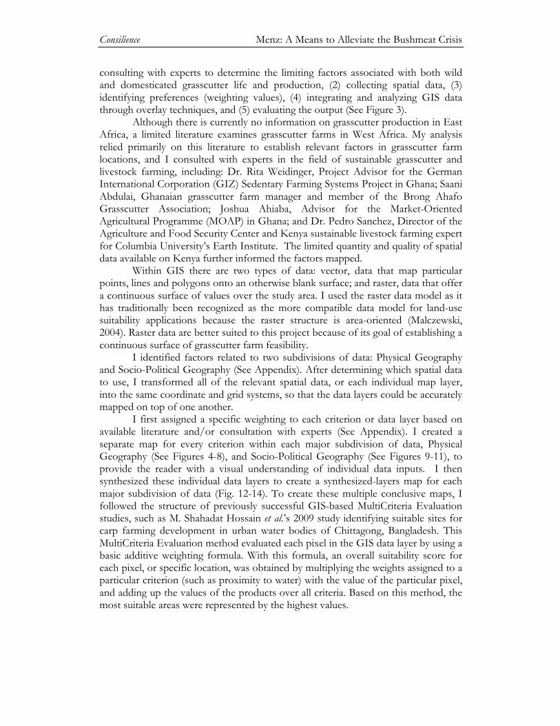
This case study presents a GIS-based land suitability analysis for identifying and measuring the suitability of potential sites for sustainable grasscutter farms in Kenya. The analysis involved five major steps: (1) conducting a literature review and
Consilience Menz: A Means to Alleviate the Bushmeat Crisis
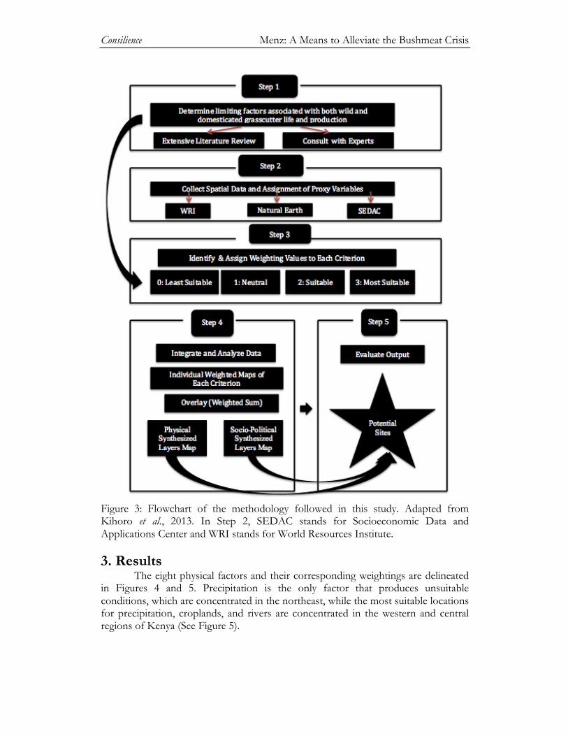
consulting with experts to determine the limiting factors associated with both wild and domesticated grasscutter life and production, (2) collecting spatial data, (3) identifying preferences (weighting values), (4) integrating and analyzing GIS data through overlay techniques, and (5) evaluating the output (See Figure 3).
Although there is currently no information on grasscutter production in East Africa, a limited literature examines grasscutter farms in West Africa. My analysis relied primarily on this literature to establish relevant factors in grasscutter farm locations, and I consulted with experts in the field of sustainable grasscutter and livestock farming, including: Dr. Rita Weidinger, Project Advisor for the German International Corporation (GIZ) Sedentary Farming Systems Project in Ghana; Saani Abdulai, Ghanaian grasscutter farm manager and member of the Brong Ahafo Grasscutter Association; Joshua Ahiaba, Advisor for the Market-Oriented Agricultural Programme (MOAP) in Ghana; and Dr. Pedro Sanchez, Director of the Agriculture and Food Security Center and Kenya sustainable livestock farming expert for Columbia University’s Earth Institute. The limited quantity and quality of spatial data available on Kenya further informed the factors mapped.
Within GIS there are two types of data: vector, data that map particular points, lines and polygons onto an otherwise blank surface; and raster, data that offer a continuous surface of values over the study area. I used the raster data model as it has traditionally been recognized as the more compatible data model for land-use suitability applications because the raster structure is area-oriented (Malczewski, 2004). Raster data are better suited to this project because of its goal of establishing a continuous surface of grasscutter farm feasibility. I identified factors related to two subdivisions of data: Physical Geography and Socio-Political Geography (See Appendix). After determining which spatial data to use, I transformed all of the relevant spatial data, or each individual map layer, into the same coordinate and grid systems, so that the data layers could be accurately mapped on top of one another.
I first assigned a specific weighting to each criterion or data layer based on available literature and/or consultation with experts (See Appendix). I created a separate map for every criterion within each major subdivision of data, Physical Geography (See Figures 4-8), and Socio-Political Geography (See Figures 9-11), to provide the reader with a visual understanding of individual data inputs. I then synthesized these individual data layers to create a synthesized-layers map for each major subdivision of data (Fig. 12-14). To create these multiple conclusive maps, I followed the structure of previously successful GIS-based MultiCriteria Evaluation studies, such as M. Shahadat Hossain et al.’s 2009 study identifying suitable sites for carp farming development in urban water bodies of Chittagong, Bangladesh. This MultiCriteria Evaluation method evaluated each pixel in the GIS data layer by using a basic additive weighting formula. With this formula, an overall suitability score for each pixel, or specific location, was obtained by multiplying the weights assigned to a particular criterion (such as proximity to water) with the value of the particular pixel, and adding up the values of the products over all criteria. Based on this method, the most suitable areas were represented by the highest values.
Consilience Menz: A Means to Alleviate the Bushmeat Crisis
Figure 3: Flowchart of the methodology followed in this study. Adapted from Kihoro et al., 2013. In Step 2, SEDAC stands for Socioeconomic Data and Applications Center and WRI stands for World Resources Institute. 3. Results The eight physical factors and their corresponding weightings are delineated in Figures 4 and 5. Precipitation is the only factor that produces unsuitable conditions, which are concentrated in the northeast, while the most suitable locations for precipitation, croplands, and rivers are concentrated in the western and central regions of Kenya (See Figure 5).
Consilience Menz: A Means to Alleviate the Bushmeat Crisis
Figure 4: Eight physical geographic parameters (a) precipitation (b) bare areas (c) wetlands (d) rangelands (e) protected areas (f) rivers (g) lakes (h) cropland in Kenya that have the potential to limit grasscutter farm location. Spatial data is from the World Resources Institute.
Consilience Menz: A Means to Alleviate the Bushmeat Crisis
Figure 5: Suitability levels of eight physical geographic parameters (a) precipitation (b) bare areas (c) wetlands (d) rangelands (e) protected areas (f) rivers (g) lakes (h) cropland in Kenya that have the potential to limit sustainable grasscutter farm placement. Weightings were determined based on literature review and consultation with grasscutter and sustainable livestock experts (Appendix 1). Unsuitable and less suitable locations based on physical data are prevalent in northern and eastern Kenya: the majority of the Rift Valley, Nairobi, Eastern and Northeastern provinces (See Figures 6-8).
Consilience Menz: A Means to Alleviate the Bushmeat Crisis
Figure 6: Land suitability analysis of the prime locations to create sustainable grasscutter farms in the eight provinces of Kenya. Suitability is based on eight physical geographic factors: precipitation, bare areas, wetlands, rangelands, protected areas, rivers, lakes, and cropland, and corresponding weightings were determined based on literature review and consultation with grasscutter and sustainable livestock experts (See Appendix).
Consilience Menz: A Means to Alleviate the Bushmeat Crisis
Figure 7: Land suitability analysis of the prime locations to build sustainable grasscutter farms at the district level in the Western, Nyanza, and Rift Valley administrative boundaries of Kenya.
Consilience Menz: A Means to Alleviate the Bushmeat Crisis
Figure 8: Land suitability analysis of the prime locations to build sustainable grasscutter farms at the district level in the Central and Coastal administrative boundaries of Kenya. These areas were characterized by low precipitation, the presence of bare and protected areas, scattered rangelands and wetlands, fewer rivers and croplands, and the absence of major lakes (See Figures 6-8). Most suitable locations were found primarily in areas where there was high precipitation; the presence of rivers, croplands, wetlands, major lakes; and the absence of bare and protected areas (See Figures 6-8). The three socio-political factors and their corresponding weightings are delineated in Figures 9 and 10. The percentage of individuals living below poverty and urban areas both produce unacceptable locations, whereas proximity to roads
Consilience Menz: A Means to Alleviate the Bushmeat Crisis
produces a mostly neutral outcome (See Figure 9). This mostly neutral outcome could be a result of the data not being extensive enough and only showing major roads. Unlike the physical data, the socio-political data produces mainly neutral locations, scattered with unsuitable clusters (See Figure 10). The main cluster of unsuitable locations is concentrated in the Nairobi province (See Figure 10).
Figure 9: Three socio-political parameters (a) poverty (b) roads (c) urban areas in Kenya with their corresponding weightings (d-f) that have the potential to limit sustainable grasscutter farm location. Weightings were determined based on literature review and consultation with grasscutter and sustainable livestock experts (See Appendix).
Consilience Menz: A Means to Alleviate the Bushmeat Crisis
Figure 10: Land suitability analysis of the prime locations to create sustainable grasscutter farms in the districts of Kenya based on three socio-political geographic factors: poverty rate, roads, and urban areas. Weightings were determined based on literature review and consultation with grasscutter and sustainable livestock experts (Appendix 2). The most suitable locations to establish sustainable grasscutter farms based on the combined physical and socio-political data are concentrated in three main regions: the Nyanza, Western and western half of the Rift Valley provinces, hereafter referred to as the Western cluster; the Central province, hereafter referred to as the Central cluster; and the south-eastern tip of the Coastal province, hereafter referred to as the South-Eastern cluster (See Figure 11).
Consilience Menz: A Means to Alleviate the Bushmeat Crisis
Figure 11: Land suitability analysis of the prime locations to create sustainable grasscutter farms in the eight provinces of Kenya. Weighted Overlay map is based on eight physical geographic factors: precipitation, bare areas, wetlands, rangelands, protected areas, rivers, lakes, and cropland; and three socio-political geographic factors: poverty rate, roads, and urban areas. Corresponding weightings were determined based on literature review and consultation with grasscutter and sustainable livestock experts (See Appendix). Within the Nyanza, Western, and western half of the Rift Valley administrative boundaries, 28 districts have at least 75% of landcover suitable for the creation of sustainable grasscutter farms (See Figure 12).
Consilience Menz: A Means to Alleviate the Bushmeat Crisis
Figure 12: Land suitability analysis of the prime locations to build sustainable grasscutter farms at the district level in the Western, Nyanza, and Rift Valley administrative boundaries of Kenya. Within the Central province, 10 districts have at least 50% of landcover suitable for the creation of sustainable grasscutter farms, and within the southern tip of the Coastal province, three districts have at least 20% of landcover suitable for the creation of sustainable grasscutter farms (See Figure 13).
Consilience Menz: A Means to Alleviate the Bushmeat Crisis
Figure 13: Land suitability analysis of the prime locations to build sustainable grasscutter farms at the district level in the Central and Coastal administrative boundaries of Kenya. 4. Discussion
Water scarcity is one of the main physical limiting factors in Kenya, and thus it is not surprising that the three most suitable regions for building sustainable grasscutter farms are all areas with high concentrations of water: high precipitation, high density of croplands and associative infrastructure (such as irrigation), lack of bare areas, scattered wetlands, and proximity to Lake Victoria and many rivers (See Figures 5-6). The expected increasing frequency of droughts, as a result of global climate change, further necessitates close proximity to water sources (Ulrich et al.,
Consilience Menz: A Means to Alleviate the Bushmeat Crisis
2012). Bare areas and protected areas were both unsuitable locations because bare areas are devoid of vegetation and generally have limited water availability, necessitating costly infrastructure construction (Weidinger, 2014); it is illegal to build farms on protected areas but they do not need a buffer, as domesticated grasscutters have an identical genetic makeup to wild grasscutters and would be disease-controlled (Weidinger, 2014).
Access to roads and proximity to urban areas were the main socio-political limiting factors (See Figure 9). If farms were located too close to roads and urban centers, there would be increased pollution, increased chance of theft, and decreased quality and availability of natural resources (Weidinger, 2014; Abdulai, 2014). Alternately, if farms are too far away from roads and urban centers, it is difficult and costly to transport meat to slaughterhouses and markets. The main political factor that limited success of grasscutter farms in Ghana was access to roads, as the transportation of grasscutter meat to markets is vital for financial gain (Abdulai, 2014). In Kenya, more extensive data on roads is necessary to determine whether or not access to roads would be a major limiting factor. The percentage of individuals living below the poverty rate, while not integral to the overall functionality of grasscutter infrastructure, was central to my research focus because one aim of this study was to provide a primary source of protein and income to impoverished Kenyans.
Implementing grasscutter farms in such suitable locations has the potential to improve the lives of local residents. One study found that livestock-related strategies helped over one-third of Kenyan households escape poverty (Kristjanson et al., 2010). In the urban and agropastoral zones, livestock commercialization, meaning selling the majority of meat versus primarily consuming it for subsistence, was essential in the transition out of poverty (Kristjanson et al., 2010). In the districts of Kisumu, Migori, and Busia, Kristjanson et al., (2010) discovered that livestock made up 30% of total income and that increased access to livestock was directly associated with significant poverty reduction. Kisumu, Migori, and Busia, are three of the 28 districts located in the highly suitable physical geographic hotbed of the Western cluster (See Figure 12). If increased access to livestock was directly associated with significant poverty reduction in these three districts, it is reasonable to extrapolate that increased access to livestock would also directly help reduce poverty in the surrounding 25 districts, especially as those districts all have very similar physical conditions and present suitable locations for potential grasscutter farms.
In the districts of Makueni, Kilifi, Tharaka, Marakwet and Laikipia, Kristjanson et al., (2010) found that over 50% of income derives from livestock activities. Marakwet is located in the northern tip of the Western cluster, Makeuni, Tharaka, and Laikipia are located in the Central cluster, and Kilifi is located in the Southeastern cluster (See Figures 12 and 13). These areas are not as highly suitable as the cluster in Western Kenya, as there are protected areas in these regions which restrict grasscutter farm establishment (See Figures 6 and 7), sprawling urban areas which increase both natural resource competition and theft potential (See Figure 9), and lower percentages of Kenyans living below poverty (See Figure 9); however these five districts are located in areas of relatively high precipitation, high densities of cropland, prevalence of rivers, scattered grasslands, and high concentration of roads which facilitate grasscutter meat distribution to markets (See Figures 5 and 9). Kristjanson et al., (2010) reported that livestock diversification and commercialization
Consilience Menz: A Means to Alleviate the Bushmeat Crisis
have potential in these areas; however, major livestock losses were due to drought (Kristjanson et al., 2010). Grasscutters are a more viable option than other conventional types of livestock as they are naturally drought-resistant; they obtain the vast majority of their water from grass and other types of vegetation (Weidinger, 2014). Proximity to water sources, such as rivers, lakes, and wetlands, and the establishment of farms on existent croplands or rangelands where irrigation infrastructure is already existent would further ensure the presence of grass and subsequently fulfill grasscutter nutritional requirements (Weidinger, 2014; Abdulai, 2014).
Despite the fact that about 20% of Kenya presents highly suitable grasscutter farm locations (See Figure 11), the establishment of sustainable grasscutter farms should not be restricted solely to these locations. Ulrich et al., (2012) conducted a study on small-scale farming in semi-arid areas in Laikipia Kenya from 1997 to 2010. The authors discovered that many rural farmers identified livestock as their most important strategy against food deficit periods (Ulrich et al., 2012). These results are encouraging as the majority of the land in Kenya falls into the less suitable range, due mainly to physical limiting factors such as lower precipitation, further distance from rivers and lakes, and resultant lower densities of croplands and rangelands (See Figures 4 and 6). Socio-political limiting factors proved to restrict a much smaller amount of space (See Figure 9). Cows were the main source of livestock for the farmers in Ulrich et al.’s 2012 study. Grasscutters, in comparison, require much less food, water, and space than cows, and thus if cows could survive in these semi-arid conditions and serve as a vital food and security source to farmers, grasscutters would seem to be an even more reliable, resilient, and economically viable option. 5. Conclusion 5.1 The Conceptual Framework
With the creation of new, multi-layered maps, this project sheds light on a possible means to combat the bushmeat crisis at the local level and provide a framework for implementing similar ventures on a national, regional, or even continental scale. This study identifies potential sustainable grasscutter farm locations in Kenya. From an applied standpoint, the maps developed for Kenya can change and adapt based on user inputs, which will be beneficial as more current and detailed data from recent censuses and surveys are acquired. Future work by myself and/or agriculture and development experts can use the conceptual framework presented in this study as a baseline, and incorporate additional layers, such as the effects of climate change on possible grasscutter-farm locations. Understanding the relationship between climate change and future sustainable livestock farms in Africa is paramount, as Africa is projected to suffer the greatest health impacts from climate change (McManus, 2012).
Additionally, future iterations of the model presented in this study could be improved with more complex modeling techniques, such as Genetic Algorithm for Rule-Set Prediction (GARP), which describes environmental conditions in which a species can sustain populations (Kolivras, 2006), and graduated maps, which effectively show high-risk and low-risk areas. The variation generated from graduated
Consilience Menz: A Means to Alleviate the Bushmeat Crisis
maps would show a continuous range rather than separating areas into unsuitable, neutral, or suitable, essentially allowing for more local detail. 5.2 Environmental Standards, Assessment Procedures, and Future Laws
The conceptual framework and methodology presented in this study could function as a universal means of determining prime locations for sustainable farms for a variety of species and at all levels of governance, and could be adapted to varying environmental conditions depending on each region. The creation and implementation of this accepted methodological standard might inspire implementation of similar environmental standards and assessment procedures on a local, regional, national, and global scale. A universal framework for establishing sustainable grasscutter farms could foster communication between actors involved in all junctures of the bushmeat trade, including local communities, private-sector interests, management regimes, government, and international logging companies, whose labor forces are often fed with bushmeat, and whose roads open new areas for commercial exploitation of bushmeat (Davies, 2002).
The maps created in this study could be useful to stakeholders not only in Kenya, but also globally, that are attempting to alleviate the bushmeat crisis, combat food insecurity in a sustainable manner, and/or provide means of economic development to developing countries. Specifically, in terms of the bushmeat trade, to resolve conflicts between varying stakeholders, conservation and development agencies should work together to address biodiversity loss and poverty, which are intricately interwoven (Davies, 2002). My methodology could provide a platform for this cooperation.
Policy and field issues need to be addressed concurrently, as many of the underlying causes of the bushmeat crisis originate from poverty, food insecurity, weak local governance, and unfavorable terms of trade at the policy level (Davies, 2002). With regard to poverty, sustainable bushmeat farms would provide a means of economic development to farmers, and all parties involved in the physical construction of the farms, production and care of the animals, as well as the marketing of the meat. Local, regional, and international policies should enable commercial activities of small-scale farmers by increasing investment in agricultural infrastructure, research, improved access to animal health information and treatments, and support competitiveness of household producers (Kristjanson et al., 2010). With respect to food security, which is established upon the three fundamentals of food availability, food access, and food use (FAO, 2003), sustainable grasscutter farms would directly address the two pillars of food availability and food access. They would provide food availability by contributing sufficient quantities of food available on a consistent basis, both on the local level through mini-livestock farms, and at the regional level through larger-scale farms; and food access, by providing sufficient resources for obtaining vital nutrients (FAO, 2003), specifically protein, which is particularly scarce in Africa. The assertion of Alary et al., (2011) that livestock represents social capital to reduce the vulnerability of households in times of food shortages and urgent health problems, can be
Consilience Menz: A Means to Alleviate the Bushmeat Crisis
extended/applied to grasscutters, as grasscutter meat can be seen as an engine for both seasonal work and security. 6. Recommendations
Beyond the conceptual model proposed in this study, educational programs are necessary to address issues in all areas of the spectrum. Instituting educational programs would raise the awareness of the general public about the severity of the bushmeat crisis and its adverse affects on the environment, economic security, and health. Grasscutter experts identified education as the greatest social limiting factor in creating successful, sustainable grasscutter farms (Weidinger 2014; Abdulai, 2014). It is thus crucial that the Kenyan government and international development agencies ensure that any intervention has a capacity-building component (Ulrich et al., 2012). Intervention should center around environmental and ethnographic research, education about the bushmeat crisis, training on how to interact with grasscutters and maintain a successful farm, and the development of infrastructure. 6.1 Future Research
To develop employment on these farms, future research could determine
which specific groups of people could benefit the most from sustainable grasscutter farms. Women are one example of a historically disenfranchised portion of the population who could greatly benefit from a sustainable means of economic security and highly nutritional food source to feed their families. Alary et al., (2011) assert that livestock is one of the only livelihood options available for women, who represent 70% of the world’s poor. One way to map areas of the greatest female disadvantage in Kenya would be to use female illiteracy and maternal mortality as proxies to measure female quality of life. Thus, future research could explore the idea and feasibility of creating sustainable grasscutter farms that targeted the employment of women.
Future research could also incorporate the element of adventure or eco-tourism. As eco-tourism is a rapidly expanding industry, future maps could integrate major locations in Kenya that attract adventure or eco-tourists, so that sustainable grasscutter farms could be built nearby. Adventure tourists tend to be interested in sustainable livelihoods (Fennell, 2008), and thus would likely be interested in paying to visit, learn about, and even volunteer on, sustainable grasscutter farms. This additional element could add another means of economic benefit to be drawn from sustainable grasscutter farming.
Eradicating the bushmeat crisis and food insecurity is highly unlikely, yet understanding the interrelated physical and socio-political factors necessary to determine the prime locations for sustainable grasscutter farming in Kenya could greatly improve global sustainable livestock farming and allow multiple sectors to work together to combat the underlying issues.
Consilience Menz: A Means to Alleviate the Bushmeat Crisis
7. Bibliography Abdulai, S. (2014). Personal Correspondence. Adu, E. K., Alhassan, W.S., & Nelson, F.S. (1999). Smallholder farming of the
greater cane rat Thryonomys swinderianus, Temminck, in southern Ghana: A baseline survey of management practices. Tropical Animal Health and Production, 31(4), 223-332. http://dx.doi.org/10.1023/A:1005267110830.
Adedapo, A. A., & Ogunjinmi, A. A. (2013). Economic aspects of Grasscutter
Farming in Southwest Nigeria: Implications for Sustainable Adoption and Conservation. International Journal of Scientific & Engineering Research, 4(10), 17-23.
Aguilar-Manjarrez, J., & Nath, S.S., (1998). A strategic reassessment of fish farming
potential in Africa. CIFA Technical paper. 32, FAO, Rome. http://www.fao.org/docrep/w8522e/w8522e00.htm.
Ahiaba, J. (2014). Personal Correspondance. Ajayi, S.I., (1974). An economic case study of the relative importance of monetary
and fiscal policy in Nigeria. Balgadesh Econ. Rev. , 2: 559-576. Alary, V., Corniauz, C., & Gautier D. (2011). Livestock’s contribution to poverty
alleviation: how to measure it? World Development, 39(9), 1638-1648. doi:10.1016/j.worlddev.2011.02.008.
Asibey, E. O. A., & Addo, P. G. (2000). The grasscutter, a promising animal for meat
production. African Perspectives: Practices and Policies Supporting Sustainable Development. Turnham, D. (Ed.). Söbredden, Gentofte, Denmark: Scandinavian Seminar College.
Brail, R. K., & Klosterman, R. E. (2001). Planning Support Systems, ESRI Press,
Redlands, CA. Carr, B. (2012). Food security in Africa. [Press release]. Retrieved from
Centers for Disease control and Prevention. (2014). Ebola Virus Disease: 2014 Ebola
Outbreak in West Africa. Retrieved from http://www.cdc.gov/vhf/ebola/outbreaks/2014-west-africa/index.html.
Central Intelligence Agency (CIA) (2013). Kenya. In The World Factbook 2013-14.
Washington, DC: Central Intelligence Agency. Retrieved from https://www.cia.gov/library/publications/the-world-factbook/geos/ke.html.
Consilience Menz: A Means to Alleviate the Bushmeat Crisis
Collins, M. G., Steiner, F. R., & Rushman, M. J. (2001). Land-use suitability analysis in the United States: historical development and promising technological achievements. Environmental Management, 28(5), 611-621.
Davies, G. (2002). Bushmeat and international development. Conservation Biology, 16,
587-589. http://dx.doi.org/10.1046/j.1523-1739.2002.01636.x. Dorling, D., & Hennig, B. D. (2011). In Focus: Global Population Shifts. Political
Insight 2(2), 34. http://dx.doi.org/10.1111/j.2041-9066.2011.00073.x. Eastman, J.R., Kyem, P.A.K., Toledano, J., & Jin, W. (1993). GIS and Decision
Making, UNITAR, Geneva. ESRI. (2011). ArcGIS Help 10.1: How weighted overlay works. Retrieved from
Hossain, M. S., Chowdhury, S.R., Das, N. G., Sharifuzzaman, S. M., Sultana, A.
(2009). Integration of GIS and multicriteria decision analysis for urban aquaculture development in Bangladesh. Landscape and Urban Planning 90, 119-133. http://dx.doi.org/10.1016/j.landurbplan.2008.10.020.
IUCN (International Union for Conservation of Nature) 2008. Thryonomys
swinderianus. In IUCN 2013. IUCN Red List of Threatened Species. Version 2013.2. Retrieved from http://maps.iucnredlist.org/map.html?id=21847.
Jori, F., Mensah, G.A., and Adjanohoun, E. (1995). Grasscutter production: An
example of rational exploitation of wildlife. Biodiversity and Conservation, 4, 257-265. http://dx.doi.org/10.1007/BF00055972.
Consilience Menz: A Means to Alleviate the Bushmeat Crisis
Kalogirou, S. (2002). Expert systems and GIS: an application of land suitability evaluation. Computers, Environment and Urban Systems 26 (2–3), 89–112.
Kapetsky, J. M. (1994). A strategic assessment of warm-water fish farming potential
in Africa. CIFA Technical Paper, 27, FAO, Rome. Kenya National Bureau of Statistics (KNBS). (2013). Population and Housing Census
(Reference ID KEN-KNBS-PHC-2009-v01). Retrieved from http://statistics.knbs.or.ke/nada/index.php/catalog/55.
Kiai, S.P.M. & Mailu, M. (1998). Kenya Country Paper: Wetland classification for
agricultural development in Eastern and Southern Africa. In Wetland characterization and classification for sustainable agricultural development. Harare: Food and Agricultural Organization of the United Nations, Sub-Regional Office for East and Southern Africa (FAO Corporate Document Repository). Retrieved from http://www.fao.org/docrep/003/x6611e/x6611e02a.htm.
Kihoro, J., Bosco, N. J., & Murage, H. (2013). Suitability analysis for rice growing
sites using a multicriteria evaluation and GIS approach in great Mwea region, Kenya. SpringerPlus, 2(265). http://dx.doi.org/10.1186/2193-1801-2-265.
Kolivras, K. N. (2006). A mosquito habitat and dengue risk potential in Hawaii: A
conceptual framework and GIS application. The Professional Geographer 58, 139-154. http://dx.doi.org/10.1111/j.1467-9272.2006.00521.x.
Kristjanson, P., Mango, N., Krishna, A., Radeny, M., & Johnson, N. (2010).
Understanding Poverty Dynamics in Kenya. Journal of International Development 22 (7), 978–996.
Malczewski, J. (2004). GIS-based land-use suitability analysis: a critical overview.
Progress in Planning 62, 3-65. http://dx.doi.org/10.1016/S0305-9006(03)00079-5.
McManus, J. (2012). Lecture 23: Impacts, Vulnerability and Sensitivity to Climate Change.
[PowerPoint slides]. In Earth’s Environmental Systems: The Climate System (EESC V2100). Columbia University.
Mockrin, M., Bennett E., & LaBruna, D. T. (2005). Wildlife farming: A viable
alternative to hunting in tropical forests? Wildlife Conservation Society, Working Paper No. 23. Retrieved from http://lgdata.s3-website-us-east-1.amazonaws.com/docs/2515/634292/WCS_WP_23-Mockrin-etal-2005.pdf.
NASA Socioeconomic Data and Applications Center (SEDAC). (2005). Global
Rural-Urban Mapping Project (GRUMP), v1. Retrieved from http://sedac.ciesin.columbia.edu/data/set/grump-v1-population-count.
Consilience Menz: A Means to Alleviate the Bushmeat Crisis
Natural Earth (2014). Kenya GIS Data. Available From
http://www.naturalearthdata.com/downloads/. Nicks, D. (2013). Western Black Rhino declared extinct: Other rhino species remain
on the brink. Time. Retrieved from http://science.time.com/2013/11/06/western-black-rhino-declared-extinct/.
Opara, M. N. (2010). The Grasscutter I: A livestock of tomorrow. Research Journal of
Forestry, 4, 119-135. doi: 10.3923/rjf.2010.119.135. Owen, O.J. & Dike, U.A. (2012): Grasscutter (Thryonomys swinderianus) Husbandry in
Nigeria: a Review of the Potentialities, Opportunities and Challenges. Journal of Environmental Issues and Agriculture in Developing Countries 4(1) 104-111.
Delaporte, E. (2002). Risk to human health from a plethora of Simian Immunodeficiency Viruses in primate bushmeat. Emerging Infectious Diseases, 8(5), 451-457. http://dx.doi.org/10.3201/eid0805.010522.
Rizkalla, C., Blanco-Silva, F., & Gruver, S. (2007). Modeling the impact of Ebola and
bushmeat hunting on Western Lowland Gorillas. EcoHealth, 4, 151-155. http://dx.doi.org/10.1007/s10393-007-0096-2.
Rouquet P, Froment J, Bermejo M, Kilbourne A, Karesh W, & Reed P. (2005). Wild
animal mortality monitoring and human Ebola outbreaks, Gabon and Republic of Congo, 2001–2003. Emerging Infectious Diseases, 11, 283–290. http://dx.doi.org/10.3201/eid1102.040533.
Sanchez, P. (2014). Personal Communication. Store, R., & Kangas, J. (2001). Integrating spatial multi-criteria evaluation and expert
knowledge for GIS-based habitat suitability modeling. Landscape and Urban Planning 55 (2), 79–93.
Ulrich, A., Speranza, C. I., Roden, P., Kiteme, B., Wiesmann, U., & Nusser, M.
(2012). Small-scale farming in semi-arid areas: Livelihood dynamics between 1997 and 2010 in Laikipia, Kenya. Journal of Rural Studies 28(3), 241-251. http://doi.org/10.1016/j.jrurstud.2012.02.003.
United Nations, Department of Economic and Social Affairs: Population Division.
(2004). World Population to 2300. New York: United Nations. Retrieved from http://www.un.org/esa/population/publications/longrange2/WorldPop2300final.pdf.
Consilience Menz: A Means to Alleviate the Bushmeat Crisis
United Nations Development Programme (2013). “Kenya: Human Development Indicators.” Human Development Reports. Retrieved from http://hdrstats.undp.org/en/countries/profiles/KEN.html.
Wandahwa, P., & Van-Ranst, E. (1996). Qualitative land suitability assessment for
pyrethrum cultivation in west Kenya based upon computer-captures expert knowledge and GIS. Agriculture, Ecosystems & Environment 56 (3), 187-202. http://doi.org/ 10.1016/0167-8809(95)00641-9.
Weidinger, R. (2014). Personal Conversation. Wilkie, D., Bennett, E., Eves, H., Hutchins, M., & Wolf, C. (2002). Roots of the
bushmeat crisis: Eating the world’s wildlife to extinction. Association of Zoos and Aquariums Communiqué 37561, 6-7.
Wilkie, D., & Carpenter, J. F. (1999). Bushmeat hunting in the Congo Basin: As
assessment of impacts and options for mitigation. Biodiversity and Conservation, 8, 927-955. http://dx.doi.org/10.1023/A:1008877309871.
World Resources Institute. (2007). Kenya GIS Data. Available from
Consilience Menz: A Means to Alleviate the Bushmeat Crisis
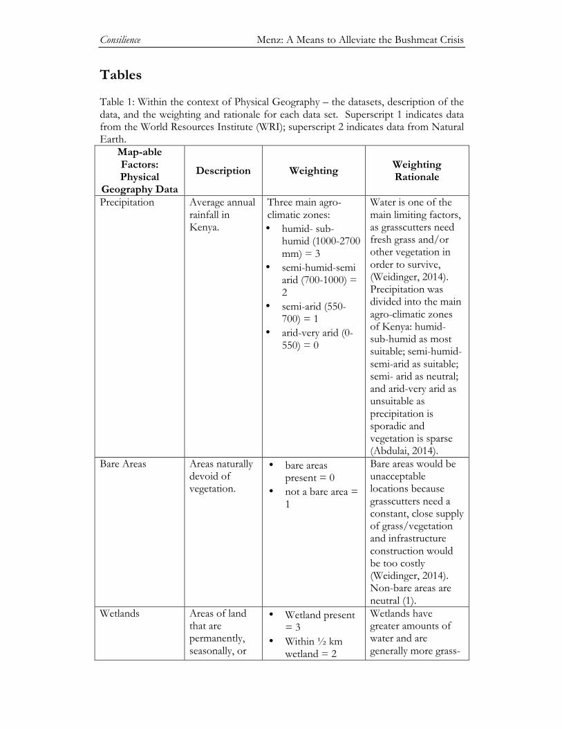
Tables Table 1: Within the context of Physical Geography – the datasets, description of the data, and the weighting and rationale for each data set. Superscript 1 indicates data from the World Resources Institute (WRI); superscript 2 indicates data from Natural Earth.
Map-able Factors: Physical
Geography Data
Description Weighting Weighting Rationale
Precipitation Average annual rainfall in Kenya.
Three main agro-climatic zones: • humid- sub-
humid (1000-2700 mm) = 3
• semi-humid-semi arid (700-1000) = 2
• semi-arid (550-700) = 1
• arid-very arid (0-550) = 0
Water is one of the main limiting factors, as grasscutters need fresh grass and/or other vegetation in order to survive, (Weidinger, 2014). Precipitation was divided into the main agro-climatic zones of Kenya: humid-sub-humid as most suitable; semi-humid-semi-arid as suitable; semi- arid as neutral; and arid-very arid as unsuitable as precipitation is sporadic and vegetation is sparse (Abdulai, 2014).
Bare Areas Areas naturally devoid of vegetation.
• bare areas present = 0
• not a bare area = 1
Bare areas would be unacceptable locations because grasscutters need a constant, close supply of grass/vegetation and infrastructure construction would be too costly (Weidinger, 2014). Non-bare areas are neutral (1).
Wetlands Areas of land that are permanently, seasonally, or
• Wetland present = 3
• Within ½ km wetland = 2
Wetlands have greater amounts of water and are generally more grass-
Consilience Menz: A Means to Alleviate the Bushmeat Crisis
occasionally waterlogged at a depth not exceeding six meters. These areas are key natural resources important for agriculture.
• 0.5 km+=1 productive so grasscutters would have food throughout the seasons (Abdulai, 2014). Areas within ½ km of the wetland would reap a lesser degree of the benefits of a wetland, but would likely still be more productive areas (Weidinger, 2014). All other areas are considered neutral.
Rangelands Grasslands and savannas that support a wide range of livestock production systems.
• Rangelands present = 3
• Rangelands not present = 1
Rangelands have greater amounts of water and are generally more grass-productive so grasscutters would have food throughout the seasons (Abdulai, 2014). If grasslands are not present the location is simply considered neutral.
Protected Areas Protected Areas.
• protected area= 0
• un-protected area= 1
Protected areas are illegal to build farms on (0), and all non-protected areas are neutral (1). No buffer was needed as domesticated grasscutters have the same genetic makeup as wild grasscutters, and there is no record of domesticated grasscutters escaping (Weidinger, 2014).
Rivers Derive from World Data Bank 2.
• 0.5 kilometers = 3
• 1 kilometer = 2
Proximity to rivers is important for production of grass,
Consilience Menz: A Means to Alleviate the Bushmeat Crisis
• everything else = 1
which is the domesticated grasscutter’s main source of food (Abdulai, 2014; Sanchez, 2014). Areas within 0.5 km of a river benefit from a year-round water source and are more agriculturally productive, and areas within 0.5 to 1 km of a river are still easily accessible by foot, bike, or other forms of transportation.
Lakes Derive from World Data Bank 2. Includes the three main water bodies in Kenya: Lake Victoria; Lake Turkana; and the Masinga Reservoir, a human-made lake.
• 0.5 kilometers = 3
• 1 kilometer = 2 • everything else =
1 • lake = 0
As with rivers, proximity to lakes is important for production of grass, which is the domesticated grasscutter’s main source of food (Abdulai, 2014). The areas covered by lakes are impossible to build on (0). Areas within 0.5 km are most suitable (3) because the lakes are a year-round water resource (Abdulai, 2014). Areas within 1km are suitable (2) because it would be feasible to move between the lake and the farm to gather fresh vegetation and/or water for the grasscutters without significant infrastructure construction or costly transportation.
Consilience Menz: A Means to Alleviate the Bushmeat Crisis
Cropland1 Areas of cropland.
• Cropland present = 3
• Cropland not present = 1
Grasscutter farms can be located within or close to croplands in order to use some of the crops, such as maize and millet as grasscutter feed (Abdulai, 2014; Sanchez, 2014). It is important to note that grasscutter farms should not be located near croplands with heavy pesticide usage (Weidinger, 2014). If cropland is not present the land is simply considered neutral.
Table 2: Within the context of Socio-Political Geography – the datasets, description of the data, and the weighting and rationale for each data set. Global Roads Open Access is from the Socioeconomic Data and Applications Center (SEDAC); Poverty Rate is from the World Resources Institute (WRI); and Urban Areas is from Natural Earth.
Map-able Factors:
Socio- Political Geography Data
Description Weighting Weighting Rationale
Poverty Rate Based on data from 1999; depicts the percentage of people living below poverty line per square kilometer in Kenya.
• 0-59.99% = 1 • 60-74.99% =2 • 75-100%=3
One aim of this study was to provide a primary source of protein and income to impoverished Kenyans, thus areas with the highest percentages of people living below the poverty line (75-100%) were most suitable.
Roads A combination of the best available roads data ranging from the 1980s to 2010.
• 0-0.5km = 1 • 0.5-3km = 3 • 3+ km = 2
The main political factor that limited success of grasscutter farms in Ghana was access to roads, as the transportation of
Consilience Menz: A Means to Alleviate the Bushmeat Crisis
grasscutter meat to markets is vital for financial gain (Abdulai, 2014). A 0.5 km buffer is necessary because air pollution from the road could be harmful to the grasscutters, and grass and other natural resources close to the roads are likely to be of lower quality, (Abdulai, 2014; Weidinger, 2014). Areas within 0.5 to 3km of a road would be most suitable as they would ensure that meat could be transported easily without significant infrastructure construction (Weidinger, 2014).
Urban Areas Represents both areas of dense human habituation and serves as a proxy for markets as GIS market data for Kenya were unavailable. Derived from 2002-2003 MODIS satellite data at 1 km resolution.
• 0-0.5 km = 1 • 0.5-3 km=3 • 3+ km= 2
The grasscutter markets should be located in highly populated areas, however the grasscutter farms should be located in less populated areas, as the most productive farm sites are in rural, vegetation-rich environments (Weidinger, 2014). As with roads, a 0.5 km buffer is necessary because of potential pollution, lower quality food sources, increased
Consilience Menz: A Means to Alleviate the Bushmeat Crisis
competition for already limited natural resources, and increased livestock theft (Ulrich et al., 2012). In Kenya specifically, from 1997 to 2010, the decrease in household livestock units was directly linked to population increase (Ulrich et al., 2012). Areas within 0.5 to 3 km of urban centers would be most suitable as they would ensure that fresh meat could be transported easily to market centers without significant infrastructure construction (Weidinger, 2014).