A National Survey of Local Land-Use Regulations Steps Toward a Beginning Robert W. Burchell and Michael L. Lahr Principal Investigators with Center for Urban Policy Research staff: William Dolphin, Carole Walker, Andrew Svelka, Bryan Grady, Arlene Pashman Submitted to: DIVISION OF AFFORDABLE HOUSING RESEARCH AND TECHNOLOGY — OFFICE OF POLICY DEVELOPMENT AND RESEARCH U.S. DEPARTMENT OF HOUSING AND URBAN DEVELOPMENT and D&R INTERNATIONAL, LTD. July 2008 ECONorthwest, Inc., Portland, Oregon Associate Investigators Terry Moore, Lorelei Juntunen Georgia State University School of Law, Atlanta, Georgia Associate Investigators Julian C. Juergensmeyer, Aaron Marks Institute on Race and Poverty University of Minnesota Law School, Minneapolis Associate Investigators Myron W. Orfield, Jr., Thomas F. Luce Graduate School of Design, Harvard University Cambridge, Massachusetts Associate Investigator Jerold S. Kayden HUD AGENCY OVERSIGHT: Regina C. Gray Edwin A. Stromberg HUD Originator Papers: Rolf Pendall, Cornell University Larry A. Rosenthal, University of California, Berkeley
Transcript
A National Survey of Local Land-Use RegulationsSteps Toward a Beginning
Robert W. Burchell and Michael L. LahrPrincipal Investigators
with Center for Urban Policy Research staff:
William Dolphin, Carole Walker, Andrew Svelka, Bryan Grady, Arlene Pashman
Georgia State University School of Law, Atlanta, GeorgiaAssociate Investigators
Julian C. Juergensmeyer, Aaron Marks
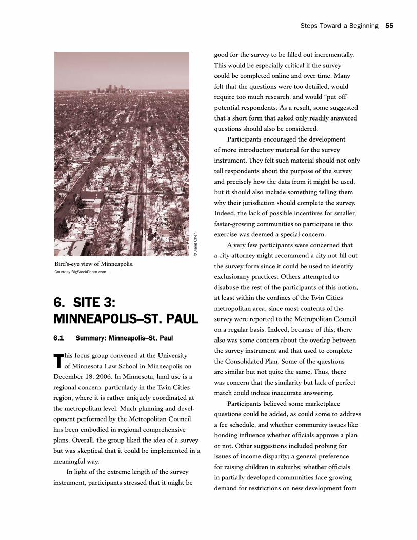
Institute on Race and Poverty University of Minnesota Law School, Minneapolis Associate Investigators
Myron W. Orfield, Jr., Thomas F. Luce
Graduate School of Design, Harvard UniversityCambridge, Massachusetts Associate Investigator
Jerold S. Kayden
HUD AGENCY OVERSIGHT:Regina C. Gray
Edwin A. Stromberg
HUD Originator Papers: Rolf Pendall, Cornell University
Larry A. Rosenthal, University of California, Berkeley
2 A National Survey of Land-Use Regulations
The contents of this report are the views of the contractor and do not necessarily reflect the views or policies of the U.S. Department of Housing and Urban Development or the U.S. Government.
This study would not have been possible without the strong commitment of the U.S. Department
of Housing and Urban Development (HUD). Mr. Edwin A. Stromberg and Dr. Regina C. Gray
of HUD’s Office of Policy Development and Research reviewed and helped shape all deliverables.
The general contractor, D&R International of Silver Spring, Maryland, oversaw the administration
of the study and ensured adherence to budgets, deadlines, and deliverable production.
Our focus group leaders did a wonderful job. Terry Moore of ECONorthwest (Portland,
Oregon); Julian C. Juergensmeyer of the Georgia State University School of Law (Atlanta, Georgia);
Myron W. Orfield, Jr., of the Institute on Race and Poverty at the University of Minnesota Law
School (Minneapolis, Minnesota); and Jerold S. Kayden of the Graduate School of Design at
Harvard University (Cambridge, Massachusetts) contributed time far beyond the scope of their
charge. Their co-researchers and staffs did an outstanding job of bringing together a diverse and
enthusiastic group of land-use professionals and academics at each site.
The focus groups, ranging from 10 to 20 professionals at each site, were superb. These
professionals know about housing development, local land-use regulations, and what responses
can be expected at the local level.
The authors of the original survey, Rolf Pendall of Cornell University and Larry A. Rosenthal
of the University of California, Berkeley, submitted timely papers in reaction to survey results.
They were staunch advocates of the survey and consistent champions of its long-term value.
The group of land-use professionals at the symposium provided both insight and field
experience that ultimately helped us decide to take the survey to its next step.
Finally, we continue to be amazed by our long-term staff at the Center for Urban Policy
Research, who can both manage the logistics of a complex undertaking (Carole Walker) and
produce results for the field in a pleasing and engaging product (Arlene Pashman). We thank HUD
for the opportunity to do the work, our co-authors for helping to carry it out, the original authors
for the survey instrument, and the multitude of land-use professionals who improved the project.
Robert W. Burchell, Ph.D.
Michael L. Lahr, Ph.D.
Acknowledgments
Steps Toward a Beginning i
Preface ............................................................................................................................. iii
Executive Summary ............................................................................................................ v
Summary of Findings ........................................................................................................ vii
Focus Group Information and Statistics ................................................................................ x
10. A National Symposium on Reaction to the Focus Group Testing (I):
Prelude to the Discussion of Reactions ........................................................................ 74
11. A National Symposium on Reaction to the Focus Group Testing (II):
Papers Presented by Rolf Pendall and Larry A. Rosenthal ............................................... 76
The National Regulatory Barriers Database Survey Design Experiment: Origins Evolution, Outcomes, and Recommendations, by Rolf Pendall ....................... 76
The National Regulatory Barriers Database Survey Design Experiment: Prospects and Challenges: Where to from Here? by Larry A. Rosenthal .................... 86
12. A National Symposium on Reaction to the Focus Group Testing (III):
Afterword to the Discussion of Reactions ...................................................................... 95
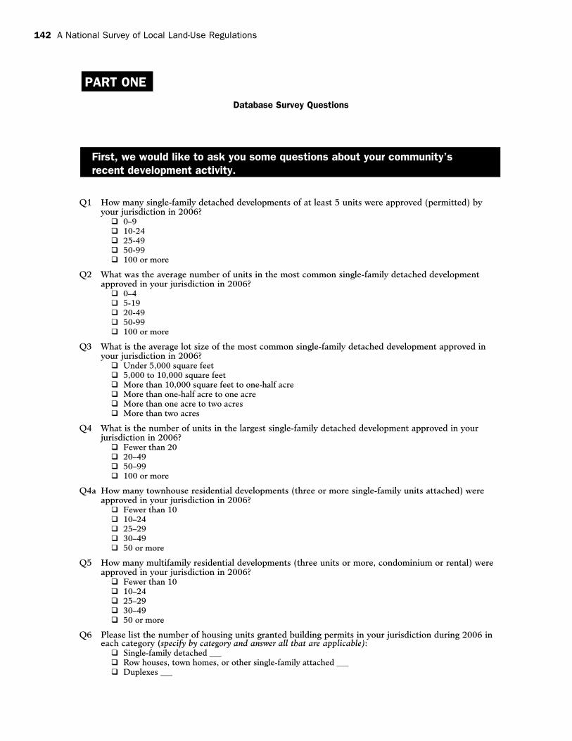
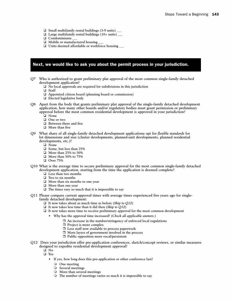
Appendix A Original Survey Instrument ........................................................................................... 99
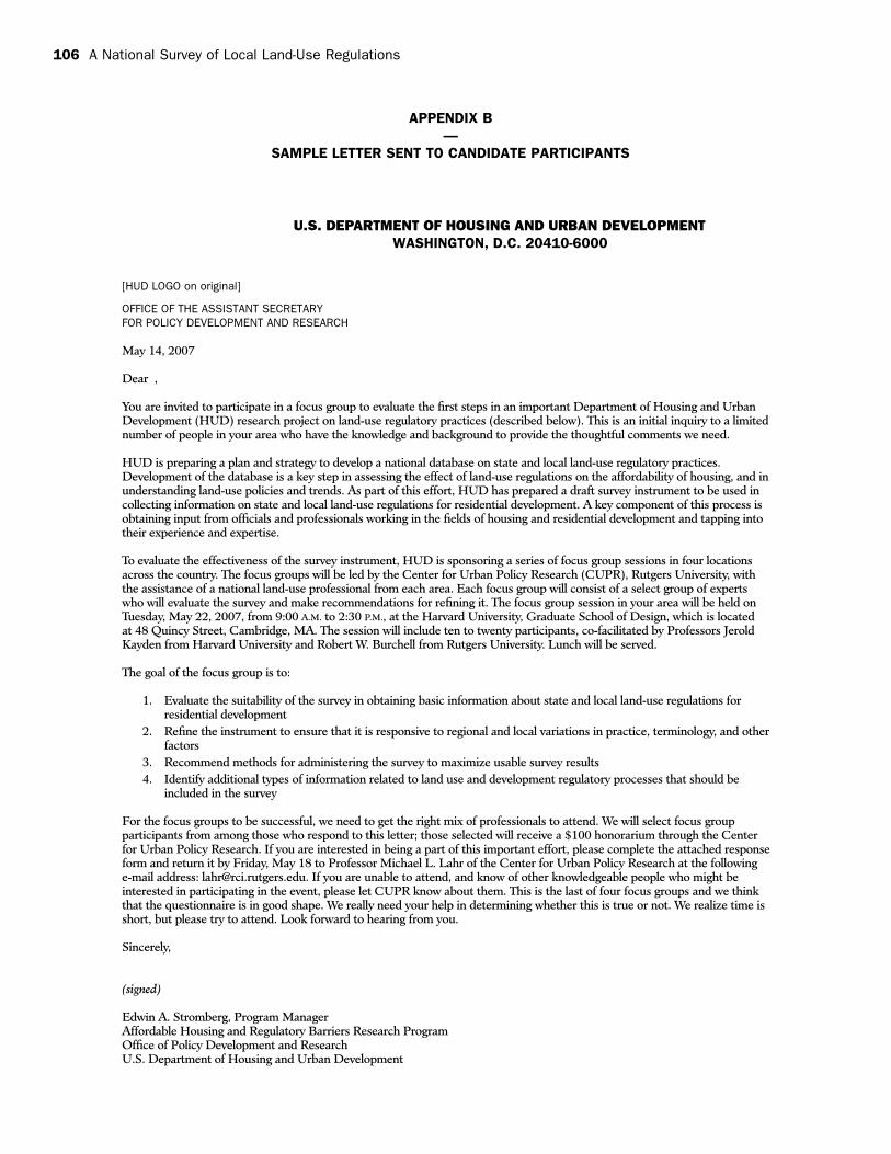
Appendix B Sample Letter Sent to Candidate Participants (Edwin A. Stromberg) .............................. 106
Appendix C Sample Facilitator’s Guide ......................................................................................... 107
Appendix d Pre-Group Questionnaire on the Survey Instrument ...................................................... 111
Appendix e Survey Instrument Discussed in New Brunswick, New Jersey ........................................ 112
Appendix F Survey Instrument Discussed in Portland, Oregon ........................................................ 121
Appendix G Survey Instrument Discussed in Atlanta, Georgia ......................................................... 130
Appendix H Survey Instrument Discussed in Minneapolis-St. Paul, Minnesota ................................. 141
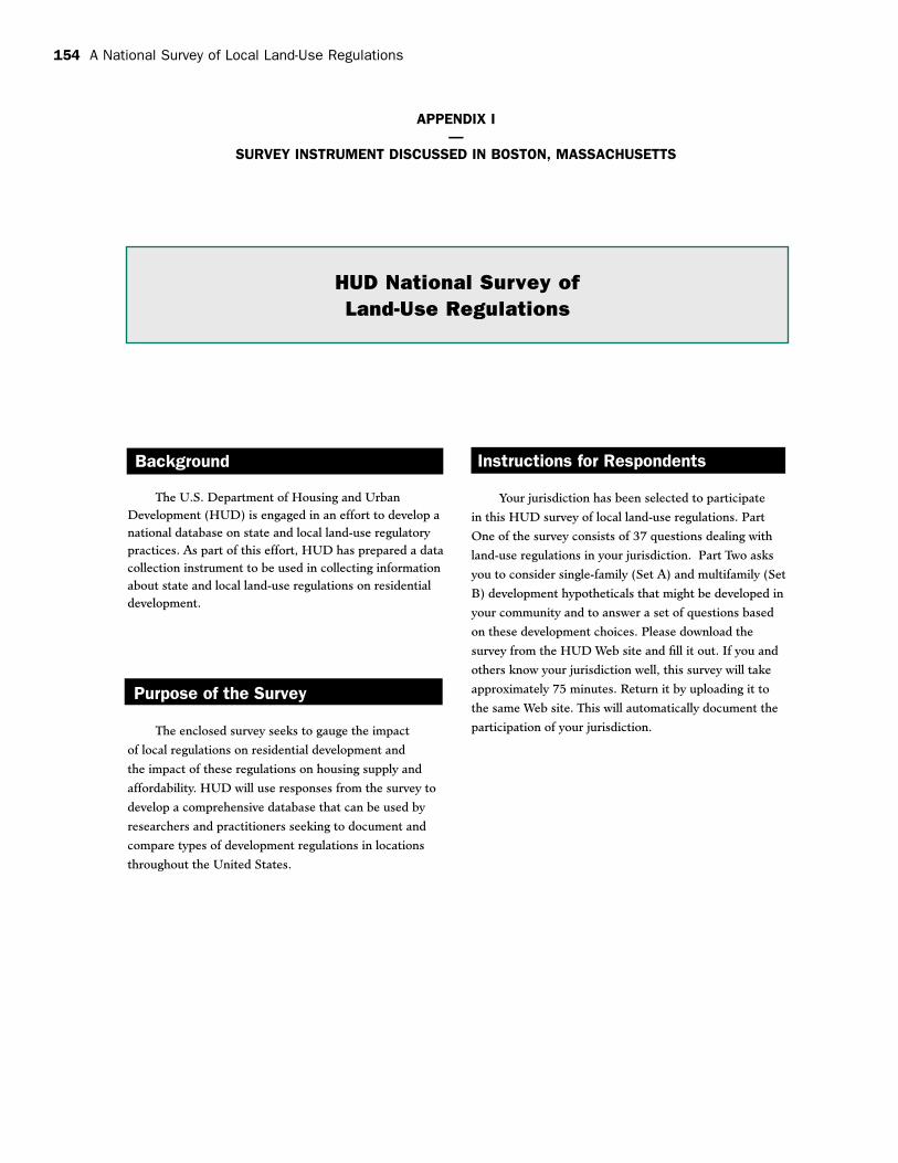
Appendix i Survey Instrument Discussed in Boston, Massachusetts ............................................. 154
Appendix J Final Draft Survey Instrument .................................................................................... 169
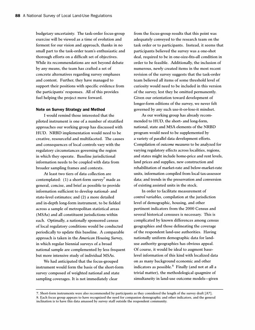
led some participants to be less sanguine about the
significance of any findings that might be derived
from them.
Also, the “greenfields” tilt of the survey was
believed not to deal with many of the key issues
facing affordable housing in New Jersey, which
is trying to focus on infill. Issues of availability of
parking, redevelopment costs, and transit-oriented
development were not touched upon.
The focus group concluded that the survey
would need to be sent in paper form to the “chief
administrative officer” in a jurisdiction but should
be filled out online by various local officials as
needed to complete a full response. The idea was
that political will would ensure response. This was
deemed the case by a majority of participants even
though a few individuals expressed concern about
the potential legal ramifications of municipalities
filling out a survey that might reveal exclusionary
practices.
The group also believed it might behoove
HUD to draw up a complementary survey for
members of the development community. It was
believed that developers could be motivated to
participate in a survey if they believed it might
reduce the number of “obstacles” faced in the
residential development process. Moreover, such
a survey would serve as a check on the survey of
governments, especially on questions pertaining to
the time it takes to bring a residential project to
fruition.
In summary, the New Brunswick pre-test
focus group was supportive of the process and
project purpose. It was generally believed that
additional focus group meetings would strengthen
the survey instrument and provide a framework for
Steps Toward a Beginning 11
implementing the survey through a wider range of
feedback. This was deemed especially true if some
of the survey’s format and navigational issues could
be resolved in the interim.
3.2 Full Proceedings: New Brunswick Pretest
3.2.1 Regional Context
Located in central New Jersey, New Bruns-
wick is part of the New York Consolidated
Metropolitan Statistical Area (CMSA). With 19.4
million residents in 2000, the New York CMSA
is the largest in the United States and represents
one of the world’s most expansive metropolitan
regions. It is a diverse region with a wide variety
of jurisdictional types, some overlapping. New
Brunswick and its surrounding communities
represent the type of suburban development that
prevails in the periphery of many large cities of
the Northeast and Midwest. In New Jersey, this
development is typified by medium- to low-density
jurisdictions with populations near or below
50,000 inhabitants.
Katz and Puentes (2006) of the Brookings
Institution Metropolitan Policy Program suggest
that among states in the nation, New Jersey
faces one of the toughest housing affordability
challenges. Its housing prices, already among the
highest in the United States, continue to rise and
to consume an ever-increasing share of New Jersey
household income. A lack of new multifamily
housing supply has helped to drive up prices for
the low- and middle-income segments of the state’s
housing market. In fact, just 12 of the state’s 566
municipalities have provided 52 percent of New
Jersey’s affordable housing units.
Despite the landmark New Jersey Supreme
Court Mount Laurel cases,1 which state that
communities should not use their delegated
police power to regulate land use in a manner that
excludes housing for low-income persons, some
localities in New Jersey continue to put regulations
in place that make development more expensive.
Throughout the state of New Jersey, more than
60 percent of municipalities restrict densities to
fewer than 8 dwellings per acre, and 35 percent
hold densities under 4 units per acre (Pendall et al.
2006).
Almost all New Jersey communities have
comprehensive plans, but many other land-use
tools that deal with capital facilities provision or
timed growth are infrequently used throughout
the state. New Jersey allows adequate public
facility ordinances, but they are instituted in
only about 20 percent of jurisdictions within
the New York CMSA. Similarly, only about
a quarter of jurisdictions impose impact fees,
while only a handful of communities report
having urban containment tools. There have been
very few residential development moratoria in
recent years, and no community has instituted a
building permit cap. Still, New Jersey, along with
Massachusetts and Connecticut, is one of the
most progressive states with regard to using local
land-use regulations to require the production of
affordable housing. In addition to court rulings and
the New Jersey Fair Housing Act, which endorsed
the use of inclusionary zoning, nearly half of the
New Jersey jurisdictions in the New York CMSA
have an affordable housing regulatory or incentive
program.
3.2.2 Focus Group Approach and Composition
The New Brunswick focus group was held at
Rutgers University’s Edward J. Bloustein School
of Planning and Public Policy on October 3, 2006.
One of the first tasks involved assembling a list of
participants. Initially, the Center for Urban Policy
1. For more information on the Mount Laurel decisions and their effect on land-use laws in New Jersey, see The Impact of Land Use Laws on Affordable Housing by Peter W. Salsich, http://www.ewgateway.org/pdffiles/blueprintdocs/landuselaws.pdf.
12 A National Survey of Local Land-Use Regulations
Research (CUPR) drew up a list of 40 potential
candidates. CUPR identified potential focus group
members by selecting professionals with expertise
in the realm of land-use regulation and affordable
housing. CUPR solicited candidates by e-mail,
with a formal invitation on HUD letterhead signed
by Edwin Stromberg. Unfortunately, with less
than a week remaining before the meetings were
slated to be under way, response turned out to be
lower than expected. As a result, the list expanded
to over 60 potential candidates. Ultimately 16
candidates accepted the invitation, but two of them
cancelled on the meeting day. The sessions were
facilitated by Professors Robert W. Burchell and
Michael L. Lahr.
The group of 14 consisted of public and
private practicing planners, developers, land-use
attorneys, and academic researchers, many of
whom were members of local planning and zoning
boards. The focus group members’ collective
experience in a state that has aggressively tried
to address its severe affordable housing problems
provides them with a unique perspective on land-
use regulations. Acutely aware of the connection
between regulation and housing prices, many have
been at the leading edge of thinking about land-use
control. Furthermore, the focus group’s location at
the Bloustein School allowed for unique interaction
between land-use practitioners and academic
researchers who also practice in the field. This
diversity of backgrounds ensured a comprehensive
understanding of land-use regulations in the New
Jersey region at the local, county and state levels.
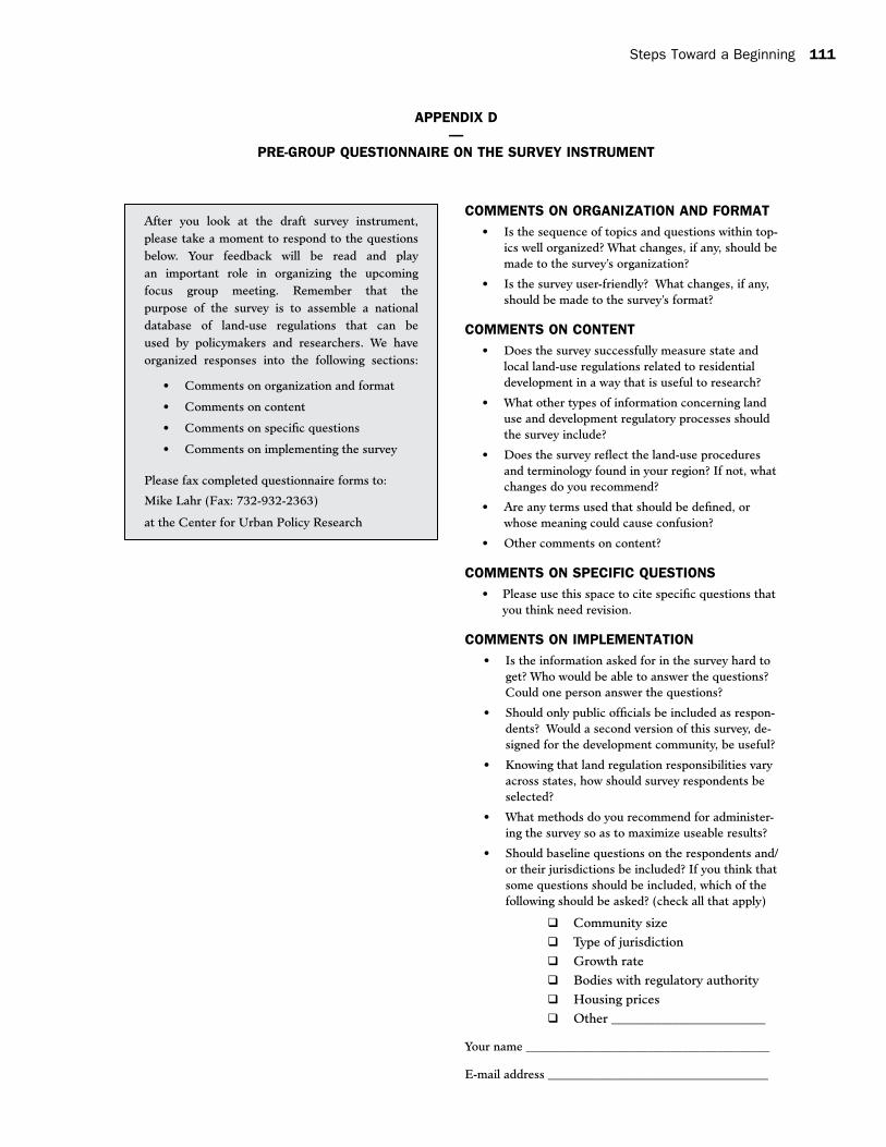
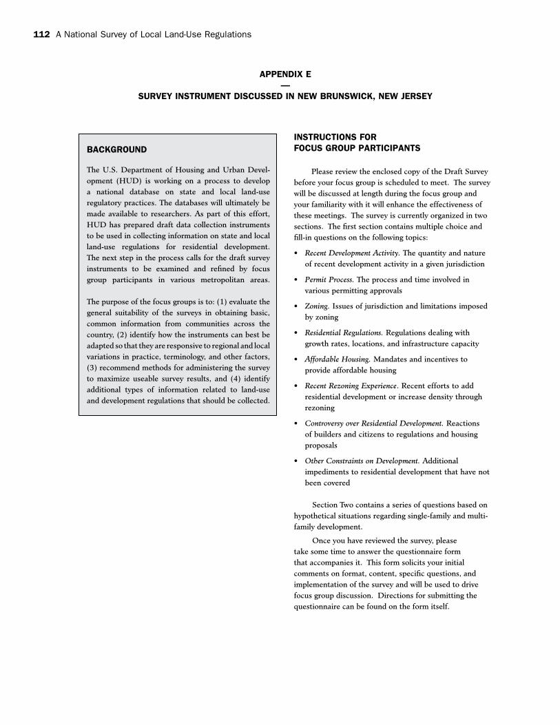
Prior to the day of this pilot test of the focus
group meeting approach, the research team
e-mailed to each intending participant a copy of
the survey instrument. The survey instrument was
accompanied by a form (see Appendix D) that was
designed to be filled out by the participant and
returned by fax before they arrived at the focus
group meetings. The intention was to generate
questions and points unique to each region that
could be used by the facilitators. The version of the
survey instrument discussed in New Brunswick was
a slightly updated copy of the original submitted by
Rolf Pendall and Larry Rosenthal, which is located
in Appendix A. A copy of the survey instrument
that the focus groups discussed in New Brunswick,
New Jersey, is displayed in Appendix E.
3.2.3 General Reaction to Project and Instrument
Several testified that their participation
showed their strong support of a national effort
to gather data on regulatory barriers to affordable
housing. Indeed, HUD’s endeavors were supported
across the full set of participants, regardless
of their specific occupation or experience.
Nonetheless, several individuals voiced concern
about some aspects of the nature of the survey
throughout the various sessions of the focus group
meeting. Most of the day was spent reviewing the
many multiple choice questions, the hypothetical
prototypes, and how a survey like this could best
be administered.
The general sentiment of participants is they
believed (1) it is possible to craft a survey that
accurately describes land-use regulations, and (2)
focus group sessions are an effective method to
discover ways to improve the instrument.
Even before format issues or concerns about
question topics were entertained, participants
almost unanimously agreed that the most
problematic issue was the length of the survey.
Of particular concern was the feeling that many
questions seemed to require an undue amount
of research; thus, participants thought the
survey would take a significant amount of time
to complete. Alternatively, they suggested that
selected questions should include an option that
allows jurisdictions to indicate that information is
not readily available. This would not only speed
up the process of filling out the survey for some
municipalities but also minimize speculative
Steps Toward a Beginning 13
answers. One sentiment that emerged during the
focus group about Part Two of the survey was
that it needed to be more concise and coherent
than currently structured. In its present form,
some participants felt that the hypothetical
scenarios had the effect of making a lengthy
survey feel dramatically longer. Moreover, the
somewhat subjective nature of the responses led
some participants to be less sanguine about the
significance of any findings that might be derived
from them.
Also, the purpose of the survey was perceived
as vague at best to many in the group. And some
terminology was thought to be less than crystal
clear. Thus, the idea of a glossary of terms was
raised. Also, much early discussion pertained to
how an introduction to the survey could be added
to motivate potential respondents to answer the
instrument and give those that intended to respond
a better sense of what the survey is all about. Some
suggested that a clearly worded enumeration of
affordable housing issues and their link to land-use
regulations would result in an increased willingness
on the part of jurisdictions to fill out this survey.
They put forward the notion that prominent
inclusion of “Affordable Housing” or “Barriers to
Affordable Housing” in the title of the survey or its
introductory materials could address some of these
of questions within each topic. While participants
made many suggestions for modifying questions
and including new ones within these topics, they
thought these categories adequately framed the
issues of land-use controls and regulations. One
structural suggestion raised in one of the two
concurrent sessions was to move the questions
inthe“Zoning”categorytothebeginningofthe
survey. The rationale was that zoning establishes
the framework by which a municipality regulates
its land.
Another theme that emerged during this
discussion of the structure and content of the
survey was the potential need to gather basic
information about the responding jurisdictions
to supplement the land-use regulation data being
requested. Suggestions for the type of information
that should be gathered ranged from qualitative
to quantitative in nature. Participants thought it
might be useful to ask respondents to characterize
their community’s character (urban, suburban,
rural), level of development activity, amount of
developable land, structure of government, and so
on. Other framework data might include census-
type information such as population, household
types, and income statistics. While most in the
group thought this information would be useful,
some cautioned that asking jurisdictions to
supply this type of information would introduce
unnecessary errors so that cross-referencing and
data-checking procedures would be needed. It
was concluded that it probably would be best to
have this information gathered independently by a
central source using existing databases.
Given the division of questions and the
issue of navigating the survey instrument in an
14 A National Survey of Local Land-Use Regulations
organized, purposeful fashion, some participants
thought more intermediate instructions should be
provided to introduce each section. They believed
this would help potential respondents better
understand the context within which the questions
in a section should be answered. Some further
indicated they had some difficulty navigating the
survey. They thought a “road map” that walks
respondents through the survey would undoubtedly
increase levels and quality of participation. For
example, instead of simply labeling Section One
“Recent Development Activity,” the questions in
that section could be preceded by a statement:
“We will begin by asking you some questions about
recent development activity in your community.”
Additional benefits of this approach might include
improved pacing and visual understanding of
a survey that appeared cumbersome to some
participants at the New Brunswick focus group.
Participants also felt that the survey could become
more “user friendly” through the use of several
survey design elements and techniques. That is,
the version of the instrument available at New
Brunswick had somewhat of an unprofessional
appearance with no room for answers. Suggested
techniques included the use of appropriate
typographical elements to enhance the look and
feel of the survey by breaking up the monotony
of a long series of somewhat undifferentiated
questions. Also, participants generally agreed that
boxes rather than bullet points for multiple-choice
answers would be better.
At the outset, some participants noted that
the survey had a heavy “greenfields” orientation.
As a result, participants affiliated with older,
denser municipalities did not perceive that the
survey dealt with many of the key concerns facing
affordable housing in New Jersey, particularly
those focusing on infill. For example, issues of
availability of parking spaces, redevelopment costs,
minimum floor-area ratios, and transit-oriented
development were not touched upon in the
instrument.
Finally, by the end of this discussion it became
clear that further elaboration on the general
topics of survey design and format are inextricably
linked to issues of implementation and feasibility.
Thoughts and recommendations on implementing a
national survey of land-use regulations appear later
in the portion of the report on the New Brunswick
sessions.
The focus group made several recommenda-
tions regarding the multiple-choice and fill-in
questions that constitute Part One of the survey.
These comments centered on word choice,
question scope, and alternative areas for inquiry.
While specific reactions to individual questions are
covered in more detail later in this section on the
New Brunswick sessions, it is worth noting that
the hypothetical questions posed in Section Two
of the survey ask respondents to consider a variety
of single and multifamily development scenarios
and judge their suitability for a given jurisdiction.
While the group thought these types of questions
could add value to the survey data, the hypothetical
questions received only mixed support due to
confusion over the organization of the section and
the general method by which respondents would be
asked to evaluate a certain scenario.
3.2.4 Reaction to Individual Questions in Part One of the Survey Instrument
The New Brunswick focus group dedicated
two sessions to examining the multiple-choice
questions in Part One of the survey. Several
recommendations and suggestions for individual
questions were generated during these sessions.
The discussion of these questions is organized by
topic and summarized below.
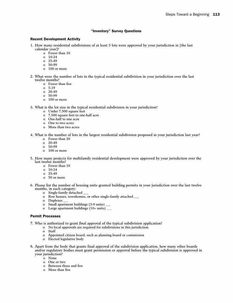
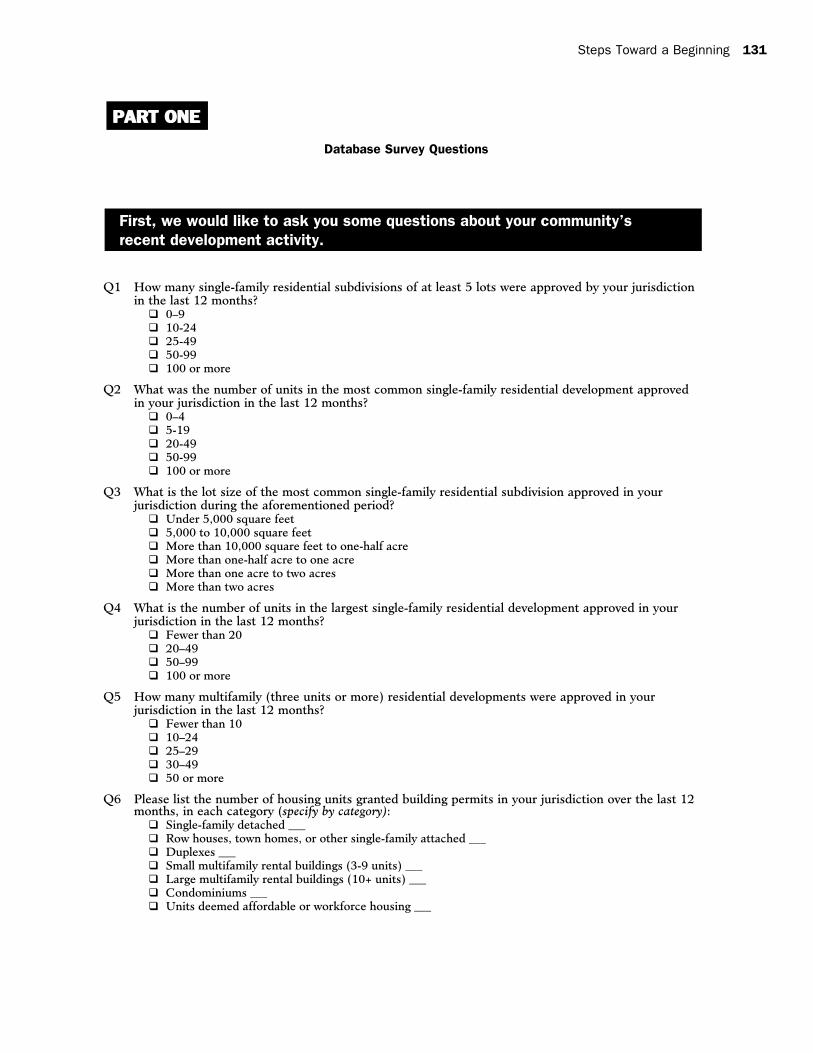
Recent Development Activity
The questions in this section of the survey
seek to measure the quantity and nature of recent
Steps Toward a Beginning 15
development activity in a given jurisdiction. The
discussion of this section focused primarily on
the terminology that was needed to make these
questions explicit yet applicable to a national
audience. Specific suggestions for altering
questions appear below:
Q1:Respondentsrecommendedthattheterm
“projects” should be used instead of “subdivision,”
and “units” should be used in place of “lots” for
questions 1, 2 and 4. The time frame of “last
calendar year” is potentially confusing and should
be simplified by using “the last twelve months.”
Also,Q1–Q4appeartobeconcernedwith
single-family development and should be labeled
assuch.Q1couldbecome:Howmanysingle
family residential projects of at least 5 units were
approved by your jurisdiction in the last twelve
months?
Q2:Similarprojectversussubdivisionandunits
versuslotsconcernasinQ1werevoicedhere.
The term “typical” first appears in this question
and is repeated several times throughout the
survey. While opinions varied about how this
would be interpreted around the country, the
group agreed that the typical development would
vary greatly from region to region. “Typical” was
identified as a potentially confusing term that
might need to be defined or changed. It was
recommendedthatQ2–Q4focusonresidential
projects that were “approved” in a jurisdiction to
capturerecentdevelopmentactivity.Q2could
become: What was the number of units in the
most common single-family residential subdivision
approved in your jurisdiction over the last twelve
months?
Q3:Inadditiontotheaboveconcerns,theintervals
presented in the answer choices needed to be
amended so that there were no overlaps. Answer
choices should be:
Under 7,500 square feet ❐
7,500 square feet to one-half acre ❐
More than one-half acre to one acre ❐
More than one acre to two acres ❐
More than two acres ❐
Q5:Thefocusgroupfoundthat“multifamily”was
a word that required definition. For instance,
does multifamily include any structure of more
than two units? It was unclear where townhouses
and condominiums fit into the definition of
“multifamily” housing. This and other requests for
definition were handled through the introduction
of a glossary. It was at least clear from discussions
that townhouses are defined as single-family
attached units on a single lot; therefore, they are
not “subdivided” onto individual lots, as are single-
family detached units.
Permit Process
The questions in this section deal with the
process of obtaining various permitting approvals
with special attention to the amount of time
required. Again, word choice was a central
focus during the ensuing discussions. The most
controversial element in these questions was the
use of the term “final” approval to signify the most
significant step in approval process. This term
crops up in questions 7, 8, and 10.
Q7:Participantssuggestedthatforgovernments
in New Jersey, “final” approval would need to be
changed to “preliminary” approval since that is
the stage at which development rights begin to
be vested. The preliminary stage is also the last
physical association that planning boards in the
state have with granting development approval.
Thus, if time is the concern, since “time is money”
for developers, this is the critical step in the
approval process. It was further recommended
that “residential” be used in place of “subdivision”
to describe the type of application that is being
approved.
16 A National Survey of Local Land-Use Regulations
Q9:Thisquestionliststhreeexamplesof
developments that may use flexible standards:
cluster developments, planned developments,
and planned residential developments. While
these terms were familiar to members of the
New Brunswick focus group, they may need
more explanation for use in a national survey.
Additionally, the names of these types of
developments may vary by region; thus, clarifying
their meanings may help respondents understand
this question.
The intervals of the answer choices also
needed to be amended so that there were no
overlapping values. The answer choices should
read:
None ❐
Some, but less than 25% ❐
25% to 49% ❐
50% to 75% ❐
Over 75% ❐
Q10:Someparticipantswonderedifthisquestion
could become more universal by using the
expression “filed” instead of “deemed complete”
to refer to the application status. It has been
left as is. The requirements for completion of an
application may vary significantly among regions.
The intervals of these answer choices also need
to be amended so that there are no overlapping
values. The answer choices should read:
Less than two months ❐
Two to six months ❐
More than six months to one year ❐
More than one year ❐
The times vary so much that it is impossible ❐
to say
Q11:Thegroupthoughtthatalthoughthis
question might be difficult to answer it was still
potentially a source of valuable information. It
may be helpful to add a fourth answer choice
for jurisdictions that are not able to answer this
question accurately.
Q12:Question12containsredundant“Yes”answer
choices. The group suggested that the first blanket
“Yes” answer be removed. The answer choices then
become:
Yes r , as of right, multifamily developments
must observe site plan approval requirements
No r
If no, why not? w
As of right, multifamily developments q
go directly to construction permits
Multifamily developments are not q
allowed in this jurisdiction
Q13:Thegroupthoughtthisquestionshould
include “elected official” along with “elected body”
as someone who may grant application approval.
Zoning
TheZoningsectionofPartOneasks
respondents to describe zoning in their community
as it relates to issues of jurisdiction and residential
regulation.
Q16:Thefocusgroupfeltthattheterm“sub
county unit” might be problematic. They suggested
using an alternate term or providing examples
such as city, township, borough, etc. The latter
alternative (listing city, township, borough, and so
on) was chosen.
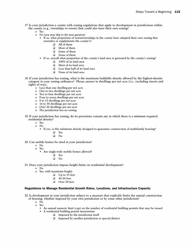
Q18:Someparticipantscautionedthatrespon
dents may not be familiar with the concept of net
acreage. Suggestions included explaining how to
calculate this figure or asking for answers in terms
of gross acres. For the time being, it was left as
is. In addition, it may be useful to repeat the
logic of this question with floor-area-ratio (FAR)
categories and parking requirements. These types
of regulations may influence development as much
as density and height regulations.
The intervals of these answer choices need
to be amended so that there are no overlapping
values. The answer choices should read:
Steps Toward a Beginning 17
Less than one dwelling per net acre ❐
One to two dwellings per net acre ❐
Three to four dwellings per net acre ❐
Five to seven dwellings per net acre ❐
Eight to 15 dwellings per net acre ❐
Sixteen to 30 dwellings per net acre ❐
Over 30 dwellings per net acre ❐
The jurisdiction has no zoning ❐
Q20:Thefocusgroupwasunsureofthe
correct terminology for describing mobile and
manufactured homes. They suggested checking
with U.S. Census guidelines to see how “mobile
home” is defined and whether this definition
includes “manufactured housing.” They also
thought that this question could become more
useful by adding these follow-up questions:
Are they allowed in places other than existing ❐
parks?
Must they meet specific provisions such as ❐
pitched roofs, attached garages, etc.?
Residential Regulations
The four questions in this section ask
respondents to describe regulations in their
community dealing with residential growth rates,
location, and infrastructure capacity.
Q22:Thegroupssuggestedaddingtwoadditional
answer choices to the “Yes” category: A sewer
moratorium and an adequate public facilities
ordinance. However, the addition of these
categories may necessitate the division of answer
choices into shorter- and longer-term measures to
limit housing construction.
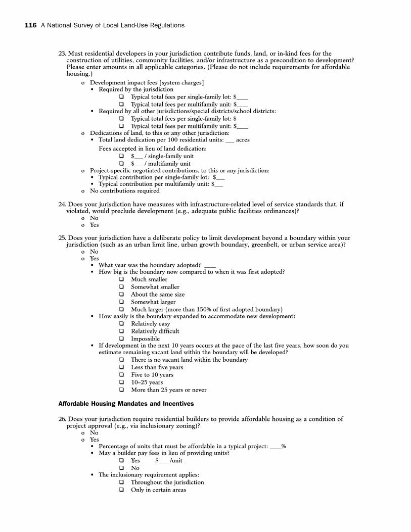
Q23:Thisisoneofthemorecomplicated
questions in Part One of the survey. Participants
stated that this sort of information would be
difficult to quantify because some fees may be
charged as a percentage of a development project,
number of bedrooms, or other similar measure
and not on a per unit or per lot basis. Some
participants suggested that providing ranges of fees
or exactions for a respondent to select might be
more effective than allowing open-ended answers.
Q24:Participantsthoughtthisquestionmight
benefit from developing the “yes” answer choice
with possibilities such as adequate public facilities
ordinances, regional plans, the Coastal Area
Facilities Review Act (CAFRA), and so on, so that
the answers became more meaningful.
Q25:Severalmembersofthefocusgroupobjected
to the wording of this question and recommended
using “Is your jurisdiction subject to a policy to
limit development. . . .” instead of “Does your
jurisdiction have a deliberate policy to limit
development. . . .”
They also suggested adding a basic question
about the effect of a development boundary:
“Has the adoption of a growth boundary affected the
availability of land and the affordability of housing?”
There may be too many options for comparing
the boundary now to when it was first adopted.
“Larger,” “smaller,” and “about the same” may
suffice.
Finally, as respondents are asked to forecast
the supply of vacant land over the next ten years,
it may be necessary to add language asking
them to consider the pace and character at
which development has been occurring in their
community. The type of development includes
density considerations that affect the development
of vacant land.
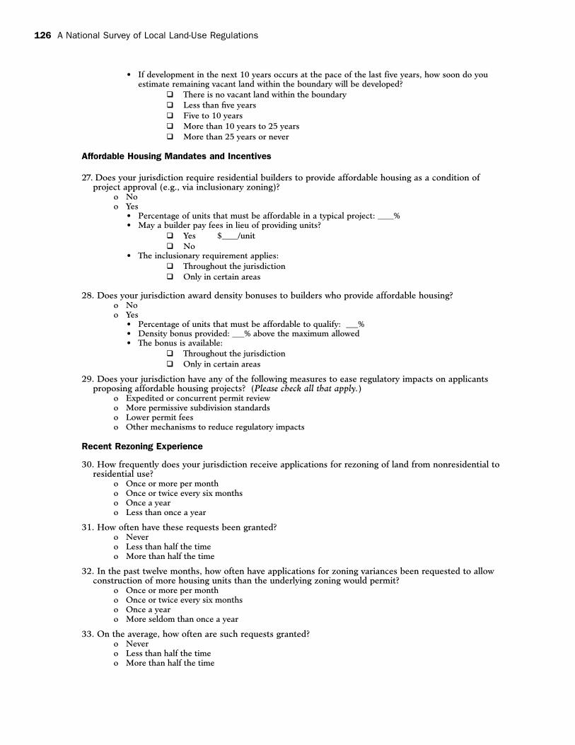
Affordable Housing
The three questions in this section ask
respondents to consider mandates and incentives
that exist in their community to provide affordable
housing. While the group thought that the
questions adequately frame affordable housing
mandates, they were concerned about a lack of
attention to certain types of financial incentives,
such as tax abatements or tax credits that may
18 A National Survey of Local Land-Use Regulations
be provided to developers who follow certain
guidelines.
Q26:Participantsfoundthat,despitetheir
familiarity with the terms “affordable housing”
and “inclusionary zoning,” these terms might
require definition or clarification. For example,
does affordable housing pertain simply to low- and
moderate-income households? Perhaps the survey
should include the issue of workforce housing, a
term used to describe the problems that moderate-
income workers often encounter when looking
for housing close to their place of employment.
The group also thought it was pertinent to ask if
there was a threshold above which inclusionary
requirements applied. For instance, does a
jurisdiction require every project over two units to
meet the same requirements?
Q27:Theanswerstothisquestionmaybemore
useful if respondents are asked to indicate whether
density bonuses are awarded at the local, county, or
federal level.
Q28:Thegroupthoughtthattwooftheanswer
choices for this question could be improved. In
the first answer choice, “expedited permit review”
should be changed to “expedited or concurrent
permit review,” and “subdivision standards” should
be replaced by “development standards” in the
second answer choice.
Controversy over Rezoning
The four questions in this section deal with
a community’s recent efforts to add residential
development or increased density through rezoning.
Because some of the questions in this section
also deal with variances, some in the focus group
thought that it should be renamed Recent Rezoning
and Variance Experience. The focus group generally
found these questions to be acceptable with very
minimal changes.
Q31:Thisquestioncouldincludebothrezoning
and variance applications as in:
“In the past twelve months, how often have
applications for rezoning or variances been
requested. . . .” Another minor point concerned
what the group thought was the awkward word
choice of “more seldom” in the final answer choice.
This could be changed to “less than once a year.”
Residential Development Decisions
The three questions in this section seek to
capture the reaction of builders and citizens to
development proposals and residential regulations.
At the New Brunswick focus group, this section
engendered some of the most divergent opinions.
Some in the group worried that these questions
would discourage jurisdictions from participating
in the survey altogether because they would not
want to disclose this sort of information and
may worry about “getting in trouble.” Despite
a suggestion that this section be removed, it has
been retained.
Q33:Jurisdictionsmaybehesitanttocharacterize
their conditions for project approval as “excessive.”
This word could be dropped from the question.
The group also felt that asking communities to
consider the past five years was difficult because it
required an “institutional memory.”
Q34:Thegroupthoughtthatlimitingcitizen
opposition to “referendum campaigns” was too
constraining. The terminology for this type of legal
opposition varies regionally. Also, it may fail to
capture other types of organized opposition such
as that organized by public interest groups or more
general appeal processes.
Q35:Thefocusgroupfeltstronglythatthis
question was not an accurate indication of the
controversy over residential development and
suggested that it be removed or refocused. The
Steps Toward a Beginning 19
group pointed out that there are several reasons
why meetings may run late into the evening, and
only some of them deal with controversy. This is in
addition to the fact that rules governing the end of
meetings may vary significantly from place to place.
Suggestions for alternate areas of inquiry include:
• Thefrequencywithwhichtheplanningboard
meets to consider development proposals
• Thenumberofmeetingsittakestogetan
application approved
• Howcontroversialmeetingswherenew
developments are being considered
typically are
Development Constraints
The final question in Part One of the survey
attempts to summarize and consider additional
obstacles to residential development in a community.
Q36:Thediscussionofthisquestionfocusedon
alternate answers that may need to be added to
make this question comprehensive. Suggestions
included:
• Mostundevelopedlandisinareaszonedfor
lower density
• Otherenvironmentalconsiderations,suchas
the presence of brownfields sites, could be
added to option two
• Thepresenceofagrowthboundaryorother
similar measure
• Thejurisdictionisnotinterestedinadditional
residential development
Summary of Additional Recommendations
One topic that some members of the focus
group did not think was addressed by the survey
is the pre-application processes available to
developers. The pre-application process provided
by a municipality may include a pre-application
conference, concept review, or “sketch plat”
designed to expedite the development approval
process. This aspect of the permit process may
be worth measuring because it can streamline the
approval process for some applications. A sug-
gested version of this question, appearing in the
Process Permit category, is:
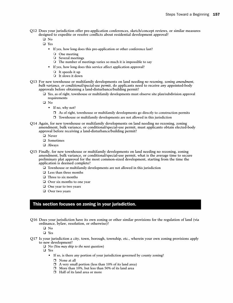
“Does your jurisdiction offer pre-application conferences, sketch/concept reviews, or similar measures designed to expedite residential development approval?
No q
Yes q
If yes, how long does this pre-application or
other conference last?
One meeting q
Several meetings q
The number of meetings varies so much it is q
impossible to say”
In addition to the specific suggestions on
individual questions, the group made several
recommendations on items or subject areas that
could be included. One recurring suggestion was to
include a glossary of terms that may not be readily
understood or that may need clarification. Opinions
varied on how this could be implemented, but the
consensus was that the glossary could be placed
at the end of the document. Terms that were to
be included in this glossary could be specifically
identified in the survey by appearing in italics or
with an asterisk indicating that a definition has
been provided. Candidates for inclusion in such a
glossary include:
• Subcountyunit
• Singlefamilyandmultifamily;forexample,
does multifamily simply mean rentals or does
it include condominiums?
• Affordablehousing
• Inclusionaryzoning
• Grossdensityandnetdensity,withnoteson
how to calculate whichever measure is used
• Mobilehomeandmanufacturedhousing
• Completenessrequirement
• “Asofright”
• Masterplan
• PUD
20 A National Survey of Local Land-Use Regulations
Participants of the New Brunswick focus
group generally thought that the survey instrument
does a good job of measuring land-use regulation
at the local level. However, some members
felt that the survey did not do as good a job at
measuring certain related aspects of residential
development that may affect affordable housing.
Some of these topics include the effect of property
taxes on housing affordability, the integration of
transportation issues and land use, environmental
regulations, state statutes, and market forces.
These factors may affect land-use decisions in a
municipality but are beyond the reach of local
policymakers. Some of these issues may warrant
inclusion in this type of survey while others may
deserve entirely separate research efforts. A
few participants also voiced concern that the
survey seems more concerned with suburban or
“greenfield” development than it does with urban
areas that are often characterized by infill projects
and mixed-use developments.
Time Required to Complete Survey
The preceding sections concerned the scope of
the survey as well as potential areas of ambiguity.
It is necessary to include some comments about
the overall time investment necessary for a
participating jurisdiction to complete a survey
of land-use regulations. Members of the focus
group agreed that answering the multiple choice
questions in Part One of the survey would require
a substantial amount of time to complete. This
opinion was based on the perceived need to
research several types of information, in some
cases over a number of years. This may involve
consulting several different people and possibly
several different departments. Acknowledging
this, the focus group also realized that the
comprehensive nature of the end database
requires a lengthy survey in order to be useful.
They also acknowledged that the cumulative
effect of implementing many of their suggestions
would make the survey longer and not shorter.
One caveat of this discussion is the possibility
of administering this survey electronically. This
may have the effect of minimizing the survey’s
perceived length. More attention will be paid to
this issue later in the report.
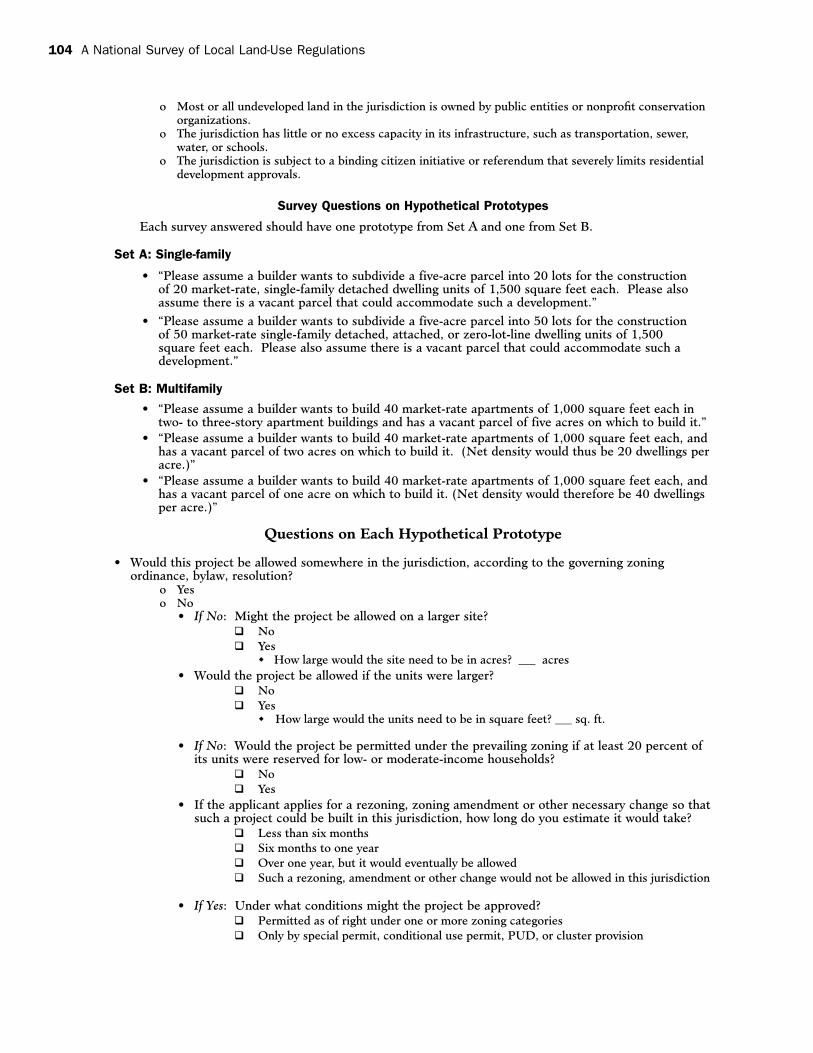
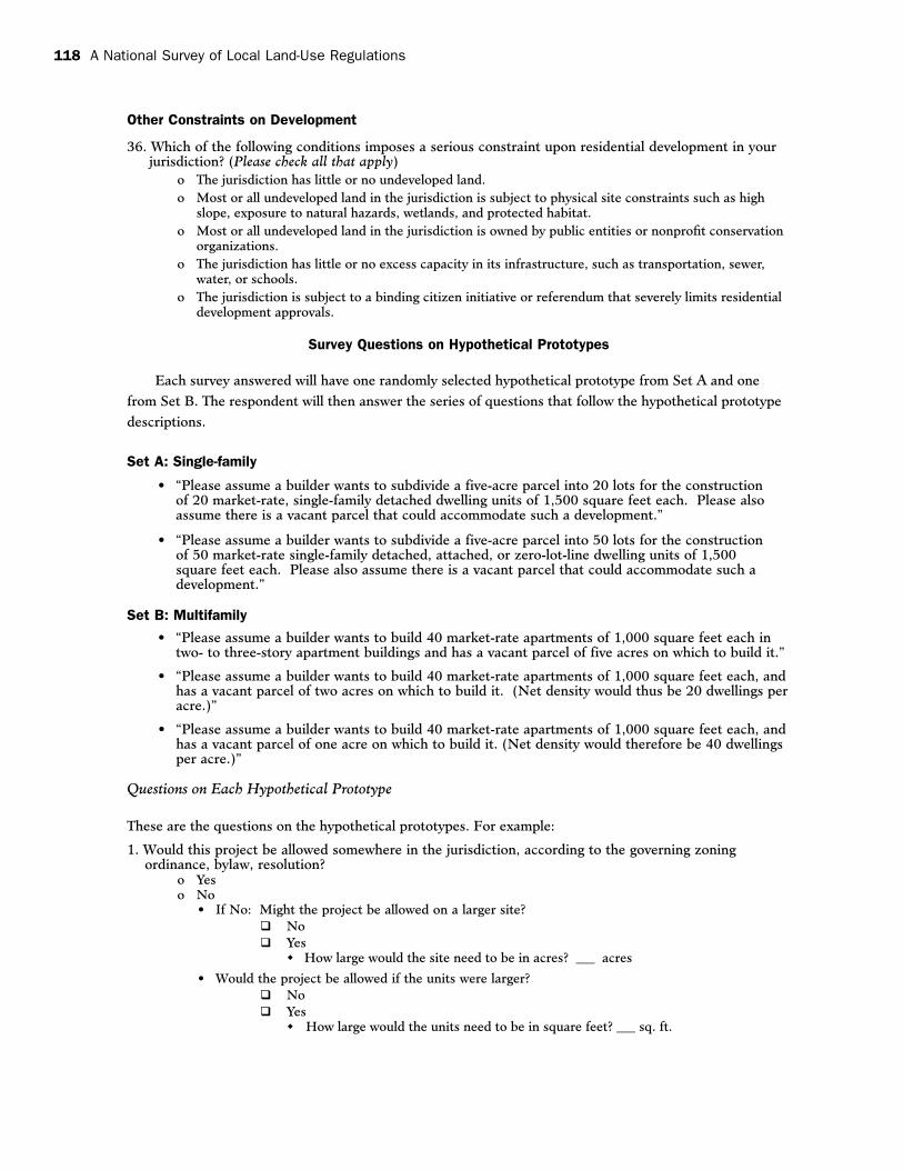
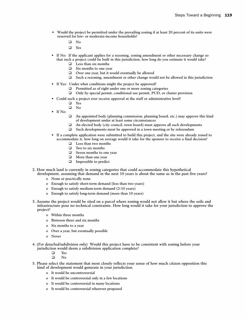
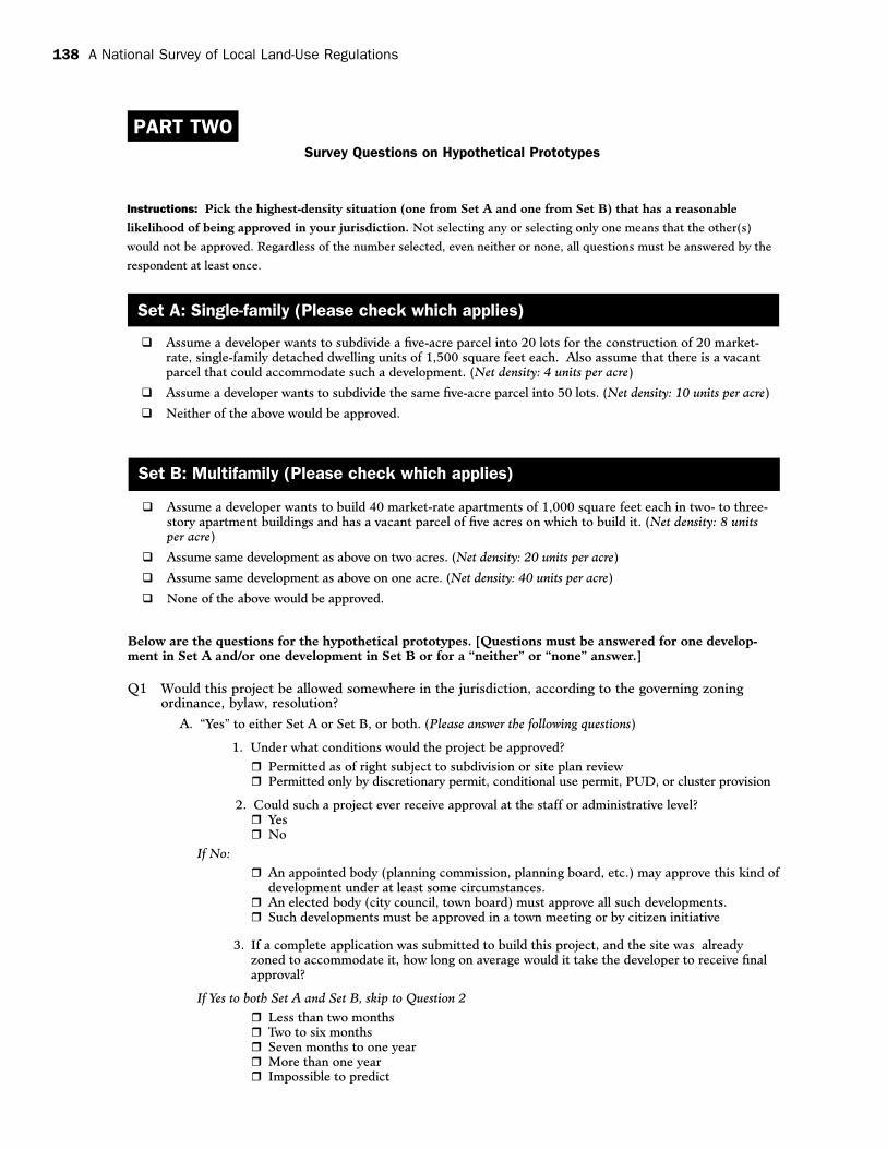
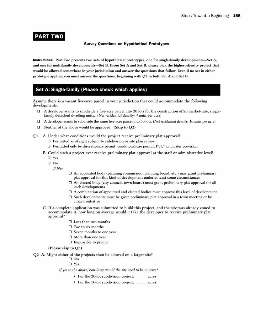
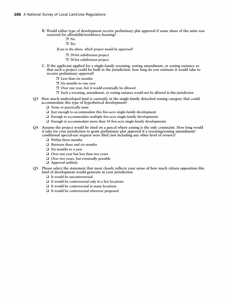
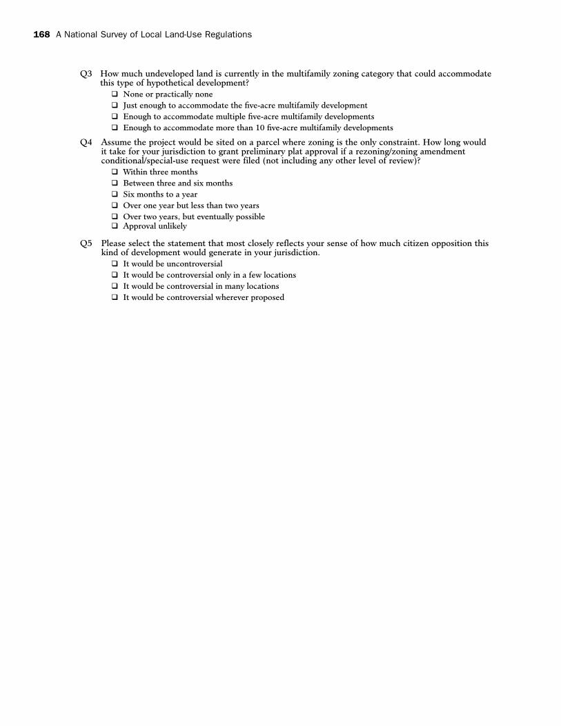
3.2.5 Reaction to the Hypothetical Prototypes in Part Two of the Instrument
Part Two of the survey embraces two sets of
hypothetical residential development situations.
Set A contains two scenarios proposing different
single-family developments. Set B contains
three scenarios outlining various multifamily
development proposals. The stated objective of the
survey is to randomly assign one hypothetical from
each set, one single-family and one multifamily,
to each jurisdiction. Each jurisdiction is to then
answer the same series of questions about each
prototype.
The New Brunswick focus group interpreted
Section Two of the survey as a way of gauging the
ease with which certain development schemes
could be built in communities around the country.
In this way, the section approaches land-use
regulations from a different perspective and
offers the opportunity to provide supplemental
information to the answers received in Part One.
Despite the potential value of this information,
Section Two was viewed as significantly more
problematic than the earlier multiple choice
questions. Several potential obstacles to effectively
carrying out these questions as well as some
suggested remedies are discussed below.
Potential Impediments
As stated, the focus group did not under-
stand the rationale for randomly distributing
hypothetical prototypes to individual jurisdictions.
Participants believed that randomly assigning
prototypes for evaluation would hinder the
usability of data collected because there were too
Steps Toward a Beginning 21
many opportunities for spatial mismatches. An
example of this type of mismatch would be a small
rural community evaluating a proposal for 40
market-rate apartment units on one acre. In this
case, the jurisdiction’s response that this type of
development would probably not be approved fails
to produce meaningful information. This response
may be influenced more by the market factors
and development character of a jurisdiction than
by its land-use regulations. The group feared that
a database comprising these types of responses
would confuse the issue of regulatory barriers to
affordable housing.
The participants voiced concern over several
aspects of the proposals and questions themselves.
For example:
• Theuseoftheword“accommodate”intheSet
A descriptions may be vague. Stating that a
vacant parcel could accommodate the proposed
development may cause respondents to wonder
if the parcel is simply the right size or if the
parcel is currently zoned appropriately for the
hypothetical project.
• Thespecificdescriptionofunitsize—1,500
square feet in Set A and 1,000 square feet in
Set B—was seen as unnecessary and possibly
distracting. The group did not feel that an
answer to the second “No” follow-up question
afterQ1woulddependonunitsize.These
scenarios seem more interested in the density
of each proposed development, so potentially
extraneous information could be removed.
Nothing was done to the questionnaire at this
time.
• ThesecondscenarioinSetA:Singlefamily,may
need to be revised. This hypothetical question
calls for the construction of 50 single-family
detached homes on a five-acre parcel, resulting
in a density of 10 detached homes per acre.
Participants seemed to think that this density
was physically unrealistic for detached housing,
specifically for a national audience.
• Referencingaspecificpercentageofaffordable
housinginQ1maybeproblematic.
Q1asksrespondentstoevaluateifthe
given hypothetical would be allowed in the
jurisdiction according to the existing zoning. If
a respondent answers “No” they are directed
to answer four follow-up questions. The third
follow-up asks them to reconsider the project
with the condition that 20 percent of its units
were reserved for low- and moderate-income
households. Some of the members of the focus
group thought the figure of 20 percent was
arbitrary. Hence, they suggested the question
might be rephrased to:
“Would the project be permitted under the
prevailing zoning if some percentage of its
units were reserved for low- and moderate-
income households?”
• Forecastinghousingdemandoverthenext
several years was perceived to be too much to
askofsurveyrespondents.Q2dealswiththe
amount of land that is currently zoned for a
proposed development and asks communities
to respond in temporal terms, i.e., enough to
satisfy medium-term demand (2-10 years).
Participants felt that quantifying demand
in this manner may be too speculative and
variable to result in meaningful data.
• ThescopeofQ4mayneedtobeenlarged
to include the multifamily proposal from Set
B. Members of the focus group were unsure
why this question directed respondents to
consider only the case of detached homes and
subdivision applications. The question should
provide a different set of answer choices for Set
A and Set B. In this way, multifamily housing
and site plans could also be considered.
22 A National Survey of Local Land-Use Regulations
• Q7maynotgenerateenoughuseable
information to warrant its inclusion in the
survey. This question asks jurisdictions to
compare themselves to neighboring jurisdictions
in terms of their regulatory climate. The group
felt if this question was going to be answered
at all by a community, the answer would be
opinion- and not fact-based. Some in the
group recommended dropping this question
entirely, saying that this is the type of judgment
a researcher could make after analyzing the
results of this survey for a region.
Suggestions for Improving the Hypothetical Prototypes
During the focus group, one sentiment that
emerged about Part Two of the survey was that it
needed to be more concise and coherent than it
was currently structured. In its present form, some
participants felt that the hypothetical questions
might have the effect of making a lengthy survey feel
dramatically longer. The discussion of this section
included several ideas which, if implemented, might
improve the presentation and effectiveness of the
hypothetical prototype questions.
As described above, the randomness of the
distribution of these prototypes was one of the
main topics of conversation. The group briefly
discussed the possibility of using some sort of
stratified random sampling technique to ensure
the statistical significance of any findings before
turning their attention to alternative modes
of distribution. Several suggestions for better
aligning the type of responding jurisdiction with
development proposals were introduced. The
proposals that communities are asked to evaluate
could be pre-selected for a jurisdiction based on
certain established criteria. This criterion could
combine size and character of development to
ensure that jurisdictions are evaluating relevant
proposals. Implementing this method could take
three forms:
• HUDselectsthemostappropriatedevelopment
proposal based on the relevant criteria and
statistics and specifically directs a respondent to
answer particular prototypes.
• Theinstructionscouldbemoregenerally
worded and invite a respondent to self-select
the most appropriate proposal to evaluate.
In this case, the directions could set up
conditional responses. For example, “If you
are a jurisdiction of this size and this type,
please evaluate Prototype One from Set A and
Prototype Two from Set B.”
• Ifthesurveyisultimatelytobeadministered
electronically, via a Web site perhaps, the
scenarios could be assigned to a jurisdiction
based on the answers provided in earlier
sections.
A variation on these methods involves more
clearly defining the intent of this set of questions.
If, as some in the focus group believed, these
questions were designed to measure a development
threshold for a community, jurisdictions might be
asked to pick the highest-density development
for which there was a chance of approval. In this
way, the survey would provide an illustration of
the upper bound of development intensity as well
as information about what factors influence that
boundary.
A more radical suggestion entailed breaking
the current survey instrument into two separate
surveys. The questions in Part One would make
up the first survey and perhaps some subset of
responding jurisdictions could be selected to
participate in the hypothetical prototype portion
of the survey. The second survey could be used to
provide extra insight into a few regions or spot-
check results in areas with conflicting responses.
In either case, respondents could be instructed
to evaluate particular proposals based on the
research goal. Another suggestion was to do away
Steps Toward a Beginning 23
entirely with Part Two. Neither suggestion was
implemented.
Finally, it is important to note that the New
Brunswick focus group felt strongly about the
need to improve the formatting and “readability”
of this section. That sentiment applies to
whichever form the prototypes and questions
ultimately appear in. Participants found the
language and structure of this section to be
confusing.Q1,inparticular,wassingledoutfor
criticism because of its length. Participants had
a difficult time keeping track of which follow-
up questions were linked to each of the general
“Yes” and “No” answers. Formatting changes,
including the use of additional white space and
more pronounced indentations, may alleviate
some of these complaints. Another suggested
improvement to the structure of this section
involves modifying its layout. Respondents
were confused by the presentation of two series
of development proposals and only one series
of questions. Arranging this section such that
each set of prototypes is followed by its relevant
questions is a simple remedy that may greatly
improve the look and feel of Part Two.
3.2.6 Implementation of a National Survey
In addition to evaluating the specific content
of the draft survey instrument, members of
the New Brunswick focus group were asked to
comment on the implementation of a national
survey of land-use regulations. The ambitious
scope of this survey necessitates a sound plan
for implementation and provides opportunity
for innovation in the delivery and collection of
these surveys. A nationwide survey will need
to select a sampling technique that provides a
representative sample of the types of jurisdictions
and range of regulations found within them.
While the group did not consider the specifics of
sampling techniques, participants were directed
to approach this task with few limitations in order
to encourage creative thinking about the subject.
The discussion during this session focused on
administering the survey, selecting respondents,
maximizing the response rate, and considering
alternate versions of the survey for related fields.
Survey Medium
The question of how to effect a national
survey invariably must include several factors.
Chief among them is the decision about the
form in which respondents will receive the
survey. The focus group seemed to agree that
using a combination of traditional and modern
dissemination would work best. The traditional
approach involves sending a paper or “hard” copy
of the survey to each jurisdiction. Respondents
would also be notified that a digital or electronic
copy of the survey would be available via a HUD-
sanctioned or -supported Web site. This hybrid
approach to distribution may have several benefits.
A paper copy is likely to be viewed as a more
formal document that must be completed, while
electronic documents have a more informal air.
Also, paper copies of the sections of the survey can
be distributed to various people or departments
who will be responsible for filling them out. In
addition, if sent as hard copy, technological
limitations would not hamper the completion of
the survey for jurisdictions lacking information
technology infrastructure. Alternatively, digital
access to the survey would allow for jurisdictions
comfortable with the Internet to complete and
process their submissions in an efficient way.
The focus group suggested that hard copies
of the survey may need to be mailed first class so
that they receive prompt attention. It was also
their strong recommendation that jurisdictions be
encouraged to complete their surveys online. This
use of the Internet would streamline the process of
data collection and management. One participant
used the example of an online college application
for comparison. Each jurisdiction could receive a
24 A National Survey of Local Land-Use Regulations
“pass code” that allows them to access the online
version of the survey. They could then have the
option of creating a password that would give them
the ability to enter the survey environment. Users
would not need to complete the survey during
one session since their answers and progress
would be saved. Upon completion, the survey
could be reviewed and submitted to HUD. A
key component of this online implementation,
according to the focus group, is the creation of a
single point of contact within each jurisdiction.
When a jurisdiction enters the survey environment
for the first time they would be required to
enter the name and e-mail address of a point of
contact in the community. This person would be
responsible for entering the information into the
online survey and could be contacted by HUD if
the need arose.
Target Audience
A second critical component of the imple-
mentation effort is the communication framework.
Who, in a jurisdiction, should receive the survey,
and who should fill it out? Participants were
asked to consider both of these questions and had
suggestions for each of them. The focus group
concluded that the survey would need to be sent to
the “chief administrative officer” in a jurisdiction.
The generic term of “chief administrative officer”
was used to signify an official position that
carried significance within a local government
structure that could potentially be filled by several
positions. According to the New Brunswick
focus group, the best candidates for this role, in
order, are municipal or county clerks, business
administrators, and mayors.
The idea behind this thinking is that the
survey recipient should have enough authority to
ensure that the survey is completed. The group
was adamant in its belief that the person receiving
the survey would not be the person responsible for
the actual entry of the survey data. Participants
suggested that the relevant chief administrative
officer should be instructed to select the most
appropriate personnel in his or her organization
to complete the survey. Participants seemed to
think that this approach would be effective in two
respects: awareness of the survey effort would
increase because a high-level official was notified,
and the eventual survey respondent may feel
compelled to complete a survey that they perceive
as coming from their “boss.”
On the subject of who should fill out a sur vey
of land-use regulations, the focus group followed
a similar logic. They suggested that jurisdictions’
contacts be asked to forward the survey to the
primary “land-use administrator” in their community.
Again, this approach uses a general term to describe
a role that may be played by different positions
across jurisdictions, such as planning department
personnel or a zoning official. This land-use
administrator may need to consult with other people
or departments in order to complete the survey, but
the creation of a single point of contact was again
suggested by the focus group.
Despite the support for this approach,
participants identified some challenges to effecting
it. A main obstacle to this strategy may be the
efficient identification of each chief administrative
officer across the various types of jurisdictions
included in the national survey. Several sources of
potentially helpful information were identified by
the focus group. State universities may maintain
information, possibly in the form of a government
services center that lists helpful information on the
governmental structure of municipalities within
the state. Similarly, each office of the secretary of
state may have current information on elected and
appointed government officials for each jurisdiction
in their state. Other sources of potentially useful
information identified by the focus group are
the National Association of Counties (NACo)
and the International City/County Management
Association (ICMA) Municipal Yearbook.
Steps Toward a Beginning 25
Encouraging Participation
The subject of how best to encourage local
government participation came up during several
sessions on various topics. These discussions
touched only briefly on the subject of using
incentives to entice jurisdictions to participate
or imposing penalties on those who declined.
The use of specific incentives, including financial
awards or linking completion to the funding of
Community Development Block Grants (CDBG),
was largely dismissed. Most in the group thought
that motivating local governments to participate
in this study was one of the biggest challenges for
HUD. The group appeared to agree that linking the
survey to the goal of reducing regulatory barriers to
affordable housing and partnering with reputable
organizations would aid the survey effort; more
thought needed to be given to this topic.
Alternate Surveys
Several times during the New Brunswick
focus group, the idea of developing a comple-
mentary survey to be completed by members
of the development community was discussed.
Participants stated that local public officials
may deal with only a segment of the residential
development process and that surveying developers
on some of these same topics would provide a
more holistic view of land-use regulations and
affordable housing. It was suggested that a
survey of this type might serve as a “reality check”
that could be used to compare and contrast the
information provided by local governments. The
example of a builder who receives the necessary
local government approvals yet cannot begin
construction on a project because of additional
regional and state regulations was given. It
was suggested that surveying developers would
illuminate the post-approval process and possibly
identify additional barriers to affordable housing.
Despite the potential benefits of this type
of information, producing and implementing a
survey for developers and builders might require
an effort similar to the production of the national
survey of local land-use regulations. The survey as
currently constructed is aimed at local government
officials and is not immediately transferable to
the development community. The development
of a shorter survey focused on how a variety of
regulations affects developers seems to be the
preferred alternative. It was suggested that HUD
could partner in this effort with the National
Association of Home Builders to develop and
distribute such a survey. Developers may be
motivated to participate in a survey that they
believe will highlight and possibly reduce the
number of “obstacles” they face in the residential
development process.
Participants identified the comparability of
these findings with the results from the govern-
mental survey as a major challenge. Developers,
unlike municipalities, do not operate within a set
of distinct jurisdictional boundaries. Similarly,
despite their expertise in some areas, they may
be unaware of some regulatory frameworks.
These concerns raised issues about the extent to
which information provided by developers could
be compared to the information given by local
governments and the degree to which it could
perform as a means of validating a national survey
of local land-use regulations.
3.2.7 Conclusion: Feasibility of a National Land Use Survey
As the pilot focus group, the New Brunswick
meeting concluded that HUD was heading in the
right direction with its national survey of local
land-use regulations. Despite the criticisms and
recommendations that appear in this report,
participants lauded HUD’s intentions and thought
that the survey would ultimately produce valuable
results. Participants thought that the series of
focus groups would undoubtedly refine the survey
instrument further. The group believed, however,
26 A National Survey of Local Land-Use Regulations
that the implementation of the survey would
remain a major obstacle to creating a reliable and
useful database of land-use regulations.
Summary of Thoughts on Survey Instrument
Participants generally thought that Part
One of the survey, containing the multiple-
choice questions, was more developed than the
Hypothetical Prototypes in Part Two. Some of the
major suggestions of the New Brunswick group
were to:
• Minimizethenumberofquestionsthatrequire
more than one person to obtain an answer by
local governments.
• Expandthesurveytoincludenonlocal
regulations that affect the residential
development. This idea was exemplified
by suggestions to include relevant state
regulations and develop an alternate survey for
development professionals.
• Limitquestionsthatcouldnotbeanswered
accurately even with some research. Certain
survey questions should include an option
that allows the jurisdiction to indicate that
information is not available so that speculative
answers are minimized.
• Standardizetheuseofpreliminaryandfinal
development application approval so that the
timing of the granting of development rights is
correctly conveyed to respondents.
• Includeaglossaryofselectedtermsin
the survey, particularly those that may be
ambiguous or confusing to some respondents.
• Developaclearmethodfordistributingthe
hypothetical prototypes so they result in
meaningful data.
• Improvetheformatandstyleofthesurvey
throughout. This is especially a concern in Part
Two of the survey, where many participants
had difficulty understanding the sequence of
questions.
Next Steps
The New Brunswick focus group was
supportive of the focus group process. It was their
belief that additional focus group meetings would
provide a wider range of feedback, which would
strengthen the survey instrument and provide
a framework for implementing the survey. The
development of a comprehensive implementation
strategy is clearly the next step in the survey effort.
Steps Toward a Beginning 27
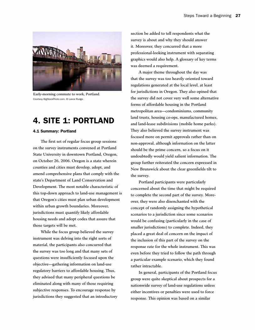
4. SITE 1: PORTLAND4.1 Summary: Portland
The first set of regular focus group sessions
on the survey instruments convened at Portland
State University in downtown Portland, Oregon,
on October 26, 2006. Oregon is a state wherein
counties and cities must develop, adopt, and
amend comprehensive plans that comply with the
state’s Department of Land Conservation and
Development. The most notable characteristic of
this top-down approach to land-use management is
that Oregon’s cities must plan urban development
within urban growth boundaries. Moreover,
jurisdictions must quantify likely affordable
housing needs and adopt codes that assure that
those targets will be met.
While the focus group believed the survey
instrument was delving into the right sorts of
material, the participants also concurred that
the survey was too long and that many sets of
questions were insufficiently focused upon the
objective—gathering information on land-use
regulatory barriers to affordable housing. Thus,
they advised that many peripheral questions be
eliminated along with many of those requiring
subjective responses. To encourage response by
jurisdictions they suggested that an introductory
section be added to tell respondents what the
survey is about and why they should answer
it. Moreover, they concurred that a more
professional-looking instrument with separating
graphics would also help. A glossary of key terms
was deemed a requirement.
A major theme throughout the day was
that the survey was too heavily oriented toward
regulations generated at the local level, at least
for jurisdictions in Oregon. They also opined that
the survey did not cover very well some alternative
residential zoning code used the Portland region as
a case study.6 The study found that housing prices
have risen rapidly in the Portland region. Given
the expected population growth in coming years,
housing affordability will probably continue to be
an important issue for regional decision makers to
address for years to come.
While most agree that housing affordability
is a problem in the Portland metro area, the
impact that zoning has had on the development of
multifamily and affordable housing in the region is
less clear. No study has definitively answered the
question of how Oregon’s land-use planning system
relates to housing prices. Some experts believe that
zoning and land-use controls (especially the urban
growth boundary) constrain land supply, causing
increases in land costs and limiting the affordability
of new housing. At the same time, most recognize
that zoning laws have played at least some part in
creating a region with a reputation for livability
that is an attractive location for new development.
Some feel that the livability of the region has
increased the demand for housing of all types and
is the real driver for price increases.
Regardless, the HUD study found that
“Oregon’s state policy framework makes it
more difficult for jurisdictions to use zoning to
intentionally limit multifamily development and
zoning in the Portland study area. The effects
that Portland’s urban growth boundary may have
on housing prices notwithstanding, zoning does
more to encourage the development of multifamily
housing units than to impede it.”
4.2.2 Focus Group Approach and Composition
The Portland focus group was held at
Portland State University in downtown Portland.
To conduct this focus group, CUPR contracted
with ECONorthwest (ECO), an Oregon-based
land-use planning consulting firm. ECO assisted
in all stages of focus group organization, from
identifying and inviting participants to facilitating
and writing these focus group results. Based on
the experience in New Jersey, ECO generated
an extensive initial list of over 60 potential focus
group participants with relevant experience
in land-use regulation and affordable housing.
They each were invited to participate via e-mail
sent from CUPR staff that included a formal
solicitation from Edwin Stromberg of HUD. ECO
followed up on e-mail invitations that generated
no immediate response. An additional set of ten
individuals was also solicited to attend. Ultimately,
nine professionals participated in the focus
group. Robert W. Burchell, co-director of CUPR,
facilitated the meeting with assistance from CUPR
and ECO staff.
The focus group participants included prac-
ticing planners, developers, land-use attorneys,
researchers, housing advocates, and members
of local planning and zoning boards. The varied
experiences that focus group participants have
had with implementing the Oregon land-use
planning system give them a unique perspective
that is useful to HUD as it considers the local
applicability of the survey.
After the New Brunswick, New Jersey, focus
group meetings, it was determined that a few
questions needed at least significant adjustments
before they could be discussed readily in a focus
group setting. In addition, participants in New
Brunswick had suggested some semantic and
other minor editorial changes to the language
used in certain questions. As a result, the survey
instrument was modified somewhat. The survey
instrument discussed in Portland, Oregon, is
presented in Appendix F.
6. Zoning As a Barrier to Multi-Family Housing Development (National Center for Smart Growth Research and Education with the American Planning Association and ECONorthwest, 2005). Report prepared for U.S. Department of Housing and Urban Development.
30 A National Survey of Local Land-Use Regulations
4.2.3 General Reaction to Project and Instrument
Nearly all focus group participants thought
that a database of local land-use regulations
could be helpful for researching solutions to the
affordable housing development problems in the
United States, and that the best way to develop
such a database is to request information about
regulations from the jurisdictions themselves.
The participants, however, had serious
misgivings about the effectiveness of a survey tool
for gathering that information. They described a
similar effort undertaken in the Portland Metro
region some years ago. The Metro government
mailed a survey to area jurisdictions that was
designed to gather information about the land-use
regulations that guide local development. Local
governments said they would not complete it
because they did not have sufficient staff support
to do so; the Metro effort failed because the
response rate was so low. Portland and Oregon
have a strong planning culture; participants were
skeptical of the ability to get a comprehensive
survey response nationally without strong
incentives or sanctions.
Participants said the survey would need a
clear plan for distribution and evaluation. It needs
to have a clearly defined audience (who will fill it
out?), an easy-to-follow logic and format, and a
well-articulated explanation of why it is important
to complete the survey (what benefits it will
deliver, and to whom). Some form of incentive or
inducement must be included, especially if the
survey is not shortened significantly.
Participants generally thought that the survey
is asking the right kind of questions, but that the
questions are not focused enough on the goal
of gathering information relevant to affordable
housing production. They advised that HUD
reassess the essential information needed to
improve its abilities and those of local governments
to help deliver affordable housing, and then to
ensure that questions in the survey probe for that
information and only that information. Peripheral
questions should be eliminated. More specific
comments about the changes that participants
suggested to the content of the survey are included
later in this document.
The Portland focus group spent a fair amount
of time discussing the format of the survey, which
everyone agreed requires some attention as the
survey is polished. Suggestions included adding
graphics to improve the visual presentation,
reducing question length or reformatting such that
the survey could be a shorter document (under 10
pages), and creating the survey as a Web-based or
downloadable document.
In particular, participants thought that the
overall length of the survey was intimidating and
would deter some respondents from completing
it. Additionally, they asserted the need for an
introductory section that sells the survey. They
contended that such a section should highlight the
problems local jurisdictions face with affordable
housing provision and explain the possible
connections to land-use regulations. It should
explain why the data that the survey gathers are so
important to addressing the problem. People may
be motivated by the potential to help alleviate a
problem that is more clearly defined.
Participants discussed the content of the
survey in general terms before going to a specific,
question-by-question review of the survey. The
most important points were:
• Theinstrumentassumesthattheregulations
are being generated at the local level, which is
not always the case in Oregon. As examples,
state law prohibits inclusionary zoning
even if local governments were interested
in affordable housing. The role of state and
federal regulations (including environmental
constraints) that affect affordability may need
to be reviewed.
Steps Toward a Beginning 31
• Thesurveyshouldexplicitlydefine“affordable
housing.” The survey authors’ definition may be
different from that perceived by respondents
and/or users of the survey data.
Other points of discussion regarding survey
content in general included the following:
• Despitetheconnectionbetweenexcessive
land-use regulation and diminished affordable
housing, the term “affordable housing” doesn’t
show up until several pages into the survey.
This immediately led some to wonder whether
the questions were very well organized, given
the stated goal of the survey.
• Thesurveyoftentriestocapturehowmany
projects/proposals were approved. Is it valuable
to capture how many are denied, delayed or
otherwise “go off the tracks,” as well as the
possible reasons? There are many reasons that
projects may stall (such as a developer financing
falling through), and only some of them are true
barriers.
• Perhapsquestionsshouldbeincludedthatask
for positive steps that are being taken by local
governments to encourage the development
of affordable housing. This may help motivate
respondents as well as generate good ideas that
can be shared nationwide.
• Thesurveyisgreenfieldsorientedeventhough
infill and redevelopment (including brownfields)
are less of a regulatory consideration in the
Northwest.
• Thesurveyfailstocapturethesignificance
of condominiums (considered affordable
housing in Portland) or other alternative forms
of affordable housing, such as community
land trusts and housing co-ops. Two trends
that don’t appear in the survey: (1) mobile
home parks being closed and converted to
subdivisions, and (2) the conversion of rental
units to market-rate condos.
In summary, there were many concerns about
the applicability of the presented survey to local
governments within Oregon. Further, participants
were somewhat troubled about the prospects of
implementing the survey—in particular, how to
motivate local governments to respond to the
instrument, especially given its extreme length and
complexity. They also expressed some unease with
the background material that accompanied the
survey as well as the instrument’s unsophisticated
appearance. Nonetheless, participants felt that,
with some adjustments, the survey can accomplish
its goals—but that HUD and the survey authors
should focus more on issues associated with the
opposing goals of adequate response rates and
survey content before it is distributed.
4.2.4 Reaction to Individual Questions in Part One of the Survey Instrument
The Portland focus group dedicated two
sessions to the examination of the multiple choice
questions in Part One of the survey. Several
recommendations and suggestions for individual
questions were generated during these sessions.
The discussion of these questions is organized by
topic and summarized below. As in the case of
this section of the report for the New Brunswick,
New Jersey, focus group meetings, the subsection
follows the general outline of Part One of the
survey instrument, which runs as follows:
• RecentRedevelopmentActivity
• PermitProcesses
• Zoning
• RegulationstoManageGrowthRates,
Locations, and Infrastructure Capacity
• AffordableHousingMandatesandIncentives
• RecentRezoningExperience
• ControversyoverResidentialDevelopment
• OtherConstraintsonDevelopment
32 A National Survey of Local Land-Use Regulations
Recent Development Activity
The six questions in this section of the survey
seek to measure the quantity and nature of recent
development activity in a given jurisdiction. The
discussion of this section focused primarily on
the terminology that was needed to make these
questions explicit yet applicable to a national
audience. Specific suggestions for altering
questions appear below.
Q1–Q3:Participantsthoughtthattheterm
“subdivision” might be too technical and literal
a term to get at the information the question
asks for. For example, in Oregon, condominiums
aren’t a subdivision. Additionally, in the
Northwest in general, subdivisions are only 5
lots or more; under 5 lots they are considered
partitions or parcel maps. Focus group members
suggested that a more generic phrase like
“residential development” might better elicit the
desired information from survey respondents.
Focus group members noted that small-scale
development in Oregon is common (especially for
infill projects) and that these smaller projects may
bemissedusingthenumericbreakoutsinQ1and
Q2.Focusgroupmemberssuggestedaddinga
category that captures projects of less than 5 lots.
Participants were confused over the use of the
terms“units”and“lots”inQ1throughQ3.They
suggestedchanging“unit”sizeinQ3to“lot”size.
Focus group members found the term
“approved” ambiguous. They noted that there
are multiple stages of approval in Oregon,
including the appeal process, and that each of
these milestones is referred to as a “land-use
decision” in Oregon. The use of the term “land-
use decision” could clear up this ambiguity.
The group thought that the word “typical”
is too ambiguous. They interpreted it to mean
average or most common, and suggested clarifying
the word.
These questions may be difficult for counties
to answer. Focus group members noted that since
Oregon has a multiple zones (rural, urban, and so
on) and that what is typical in one zone will differ
dramatically in another, some questions may be
difficult for counties to answer. Changing questions
to reflect this multi-zone reality might make county
respondents’ answers more useful.
The group pointed out that an even smaller
breakout may be needed in the response categories
inQ3,asmanylotsinsomepartsofOregonwill
fall below the 7,500-square-foot threshold.
Q4:Participantsnotedthatthisquestionasks
about “proposed” projects when previous questions
focused on “approved” projects. The group noted
that the largest proposed project may be drastically
different from the largest approved project.
Additionally, the group noted that it is wrong to
assume that local regulations are the sole reason
that a project might be proposed but not approved.
Q5:FocusgroupmembersnotedthatinOregon,
3 units or more is considered “multifamily.”
Q6:ThegroupsuggestedthatthelistinQ6should
include condominiums.
Permit Process
The questions in this section deal with the
process of obtaining various permitting approvals
with special attention to the amount of time
required. Again, word choice was the central focus
during the discussion of these questions. Unique
Oregon laws made terminology in many of the
questions difficult for participants to understand
and answer. More details follow.
Q7–Q12:Thesequestionsappeartobeconcerned
with single-family homes only; if this is true, that
terminology should be added to the questions.
Q7:InOregon,preliminaryapprovaliswhere
most of the significant action occurs, but it is
Steps Toward a Beginning 33
important to note that each jurisdiction handles
this process somewhat differently. This question
should probably use preliminary approval. “Land-
use hearings officer or body” should be added to
the list of potential answers.
Q12:The“preapplicationconference”shouldbe
the leading terminology here. In many instances
preapplication may consist simply of a single
meeting and not a process as implied in the follow-
up question. Participants thought that the follow-
up question is vague. Further, not every developer
views these meetings as a timesaving device. In
Portland, “neighborhood meetings” are regularly
held and popularly believed to help speed the
process. These meetings are combined with strong
zoning power so there is not as much room for
debate.
Q13:Therewassomeconfusionoverthephrase
“as of right.” In Oregon, state law allows no
discretionary standards to be applied.
Q13–14:Arethesequestionsredundant?Q13
asksaboutlocalgovernmentapprovalandQ14
asks about approvals from local officials or bodies.
Does this topic justify 2 questions?
The focus group participants did not have any
majorconcernswithQ8throughQ11,Q14,and
Q15.
Zoning
The section on zoning in Part One of the
survey asks respondents to describe zoning in their
community as it relates to issues of jurisdiction
and residential regulation. Participants pointed
out that, in Oregon, jurisdictions are required to
undertake comprehensive planning, which includes
a plan map that may or may not regulate uses with
something called “zoning.” The use of that term
might confuse this section.
Q16:Participantssuggestedchangingthewording
to “ . . . have its own zoning or other similar
provision for the regulation of land. . . .” to include
places like Portland that don’t technically have
zoning.
Q17–18:ParticipantsnotedthatQ17andQ18
generally are confusing and are a roundabout way
of getting the information regarding whose zoning
(the city or county) is dominant. Participants
suggested rewording these two questions to make
them more concise and less confusing, and making
sure that the response categories include an
appropriate range of subcounty units.
Q19:Thegroupexpressedconcernoverthefact
that the maximum buildable density allowed may
not be indicative of very much actual development,
or may apply only to a very small portion of
the jurisdiction. They added that a follow-up
question may be useful: What percentage of your
jurisdiction falls under this zoning category?
Participants noted that it may be important to
breakdowntheanswertoQ19intosinglefamily
and multifamily zoning types, and that the answer
could contain two columns, one for single-family
and one for multifamily, with the same answer
categories.
Q20:Participantssuggestedadding“Ifyour
jurisdiction has zoning or a plan” (again for places
like Portland) to the opening. They noted that the
“If Yes” answer is purely opinion and probably
won’t result in meaningful data. Additionally, the
group noted that, technically, minimum density
is not “designed” to guarantee multifamily con-
struction; other zoning categories may also have
minimums.
Q21:Thegroupsuggesteddistinguishingbetween
mobile and manufactured homes. The group liked
the idea of adding a follow-up question: “If so,
are mobile/manufactured homes allowed only in
existing mobile home parks?”
They suggested other follow-up questions:
Is manufactured housing allowed in single-family
34 A National Survey of Local Land-Use Regulations
zones? Is it allowed in multifamily zones? And
if so, what conditions are required of it: pitched
roofs? attached garages? All of these factors may
act as barriers. A separate survey targeted to
developers might capture this information.
Q22:Participantssaidthattheconnectionto
affordable housing or barriers is vague on this
question as most or all zoning categories have
height limitations as part of their designation.
Participants suggested that if height is being used
as a proxy for increased density, the question may
need to be reworked.
Residential Regulations
The four questions in this section ask
respondents to describe regulations in their
community dealing with residential growth rates,
location, and infrastructure capacity.
Q23:Focusgroupmembersnotedtheneedto
distinguish between temporary and longer-term
moratoriums. The question asks about annual
limits but the answer choices include options that
do not fit this time frame. The group noted that the
question may benefit from breaking out the answer
into both temporal and absolute categories.
Q24:Participantssuggestedthatthisquestion
be rewritten or reformatted, noting that some
of these developer contributions may not be a
“precondition” and so may get lost in the counting.
The group also had some discussion over whether
there are too many categories of answers, noting
that school districts/special districts may not
deserve a separate section. Additionally, the group
noted that these fees are not consistent across all
projects: They will vary, and some are discretionary.
Q25:Thegroupsuggestedchangingtheword
“violated” to the phrase “that if not met.” This
questionseemstoberelatedtoQ23(annuallimits)
and could be used to capture absolute limit types
that are not considered on a yearly basis.
Q26:Focusgroupmembersnotedtheneedtoask
when a boundary was “originally” adopted, as land
availability may change over time and a boundary
readopted. The group suggested asking how often
boundaries have changed and who determines the
size of the boundary.
The group discussed whether Portland’s UGB
has had a negative impact on affordability, noting
that this question implies that UGBs have negative
effects. Some participants took offense with this
assumption. The group suggested including a
direct question: “Does your boundary affect the
supply and/or price of housing?”
In the last section, participants suggested that
the survey distinguish between vacant land and
vacant land that has access to urban services.
Participants noted that some UGBs (such as
those in the Portland Metro area) are regional;
some towns within them may have room to grow
while others may not.
Affordable Housing
The questions in this section ask respondents
to consider mandates and incentives that exist in
their community to provide affordable housing.
Q27:Participantsnotethataffordablehousingwill
need to be defined. Does it matter if development
provisions specify how long it must be maintained
as an affordable unit? What about if it’s an
affordable unit available only to a certain age
category? Does it have to be multifamily?
The group noted that Oregon state law
precludes inclusionary zoning, so an “If not, why”
category may appease local governments and
capture the real reason that affordable housing is
not being provided.
Recent Rezoning Experience
The questions in this section deal with a
community’s recent efforts to add residential
development or increased density through rezoning.
Steps Toward a Beginning 35
Q30:Participantssuggestedthatitmightbeuseful
to capture movement the other way—instances
when residential land is used for nonresidential uses
and taken out of supply.
Q31:ThegroupsaidthatrespondentsinOregon
would typically answer “never” for this question.
Additionally, the group suggested that quantifying
this answer may also help. For example, how much
net acreage or units of housing are either gained or
lost in a typical year?
Q32–Q33:Thefocusgroupnotedthatvariances
are not allowed in Oregon. Respondents here
would answer “Never” or “Not permitted” on these
questions.
Participants suggested that this question could
include both rezoning and variance applications,
as in: “In the past twelve months, how often
have applications for rezoning or variances been
requested?”
Residential Development Decisions
The three questions in this section seek to
capture the reaction of builders and citizens to
development proposals and residential regulations.
Some in the group worried that these questions
would discourage jurisdictions from participating
in the survey. Additionally, participants felt that the
questions and response choices presented are not
always fair measures of level of controversy, but
might instead suggest poor meeting administration
or differences in the legal structure that guides
the process of administering the land-use system.
Since citizen involvement (often through appeal
process and meetings) is viewed as positive in the
Northwest, some in the group questioned why it is
important for the survey to measure “controversy.”
Q34:Thegroupnotedthatlawsuitsareveryrare
in the Northwest and suggested the addition of
the appeal option, which is much more common.
The group suggested the following wording instead
of “Has your jurisdiction been sued?”—“Has a
decision in your jurisdiction been subject to appeal
or lawsuit….”
Q35:Participantsnotedthatreferendadon’tapply
in Oregon and that interested parties may try
to appeal a “land-use designation.” Participants
said that controversy in Oregon may center
on “annexation votes,” but most disputes are
resolved through a series of compromises with the
developer.
Q36:Thegroupnotedthattheendingtime
of meetings is not necessarily indicative of
controversy. They suggested a more direct
question: “How controversial are meetings where
new residential division projects are introduced?”
Alternatively, the group suggested a question that
seeks to capture how many appeals have occurred
or what percentage of projects has been appealed.
Development Constraints
The final question in Part One of the survey
attempts to summarize and consider additional
obstacles to residential development in a
community. The group suggested that the following
new categories be added:
• Smalllotsrequireassemblage.
• Muchoftheundevelopedlandisprivately
owned and not available for development.
• Notonlyistherenoexcesscapacity,some
vacant land has no capacity.
• Vacantlandisinlowerrequireddensityzone.
4.2.5 Reaction to the Hypothetical Prototypes in Part Two of the Instrument
The logic of randomly selecting hypothetical
prototypes to which particular jurisdictions would
respond was not clear to the Portland focus
group. Participants also stressed that simply
sending “denser” hypothetical questions to larger
36 A National Survey of Local Land-Use Regulations
jurisdictions may not work since the size of a
city or town is not necessarily indicative of the
character or speed of its development, which is
key. It may also be difficult to pair these situations
with relative market demand in jurisdictions.
For example, some small towns next to growing
metropolitan areas may be developing large
subdivisions while larger built-out cities within
metro areas may not be.
Focus group participants thought that,
with proper staff support and time, most local
governments would be able to complete this part
of the survey, but the amount of time and effort
required is daunting. HUD should think carefully
about the value of this exercise from a research
perspective, as including it in the survey could
negatively affect response rates, and it is not clear
that it provides enough new information to warrant
that risk.
Portland focus group participants proposed
that this part of the survey be organized differ ently:
respondents should be asked to pick the highest-
density situation that had a reasonable likelihood of
being developed in their jurisdiction. One scenario
would be selected from Set A and one from Set B.
If the situations are used instead in their current
format, the descriptions in both Set A and Set B
could be consolidated because all the information
contained within them is identical except for the
relative density of the proposed development.
Comments on specific questions follow below.
Q1:Ingeneral,thisquestionistoolongandisvery
difficult to follow. Some specific wording changes
were suggested for the first set of “yes” responses:
• Permittedasofright,subject to subdivision
review, under one or more zoning categories
• Onlybydiscretionarypermit(insteadof
“special” permit)
Also, the third section under “No” generated
discussion. The group interpreted this question as
asking whether the project would be permitted if it
was awarded a density bonus. This may or may not
be the case, but the question needs to be clearer as
to what it is asking. Either way, listing a specific
percentage of affordable housing (20 percent) was
distracting and appeared arbitrary. Participants
suggested that no specific percentage be listed.
Q2:Participantsnotedthatthetemporalcom
ponent required by these answers makes this an
especially difficult question. Simply asking how
much land is currently in the relevant zoning
category is reasonable, but asking respondents to
forecast demand as far as ten years out may be too
complicated a request. Some of the participants
are required to produce models predicting future
development patterns and reported that they
would have trouble answering this question. Focus
group members suggested that perhaps the best
solution is to ask how much land is currently
available across several broad zoning categories.
The answers could be compared against future
responses.
Q3:Thegrouphadseveralproblemswiththis
question. They suggested adding the following
language to the last line of the question: “How long
would it take for your jurisdiction to approve the
project if a rezoning/variance request were filed?”
Participants noted that in Oregon, the answer
would usually be “never.” If current zoning did not
allow for it, the project would never be approved.
The fact that soils and infrastructure pose no
technical constraints did not seem relevant to
the group and would have little bearing on the
alternate land-use decision.
Q7:Thegroupthoughtthisquestionwouldbe
confusing and difficult to answer. A county may
have restrictive and less-restrictive municipalities
within its own boundaries and border other
counties with a similar mix of municipalities.
This inquiry raises the additional questions of
Steps Toward a Beginning 37
who survey respondents are supposed to compare
themselves with in order to answer. Furthermore,
the group noted that “restrictive” is a relative
term, making it unclear whether the term refers to
processing times or to density allowances or some
combination of the two.
Focus group members suggested that an
alternative would be a question that seeks to
establish relative benchmarks for measuring
restrictiveness rather than setting up a situation of
peer comparison.
4.2.6 Implementation of a National Survey
In addition to evaluating the specific content
of the draft survey instrument, members of
the Portland focus group were asked to give
suggestions on survey implementation. To ensure
effective results, a national survey of this type
requires a sampling technique that will provide a
representative sample of the types of jurisdictions
and range of regulations found within them.
The discussion during this session focused on
administering the survey, selecting respondents,
and maximizing the response rate.
Survey Medium and Distribution
The first question participants asked when
discussing the format and distribution of the survey
was related to budget. Recognizing that the budget
will most likely be limited, the group agreed that
linking participation to some other sort of incentive
that will maximize any budget available was
important. Some possibilities the group considered
follow.
• Selectcertainjurisdictionsineachstateand
target their participation through the use of
financial compensation. This would allow HUD
to control the quality of response and assure
representative responses. Possible obstacles
to this method center on HUD’s ability to
pay local jurisdictions for participation. It
is unknown if HUD could “contract out this
work” and go through a subcontractor to
achieve the same objective.
• Requirecompletionofthesurveyasapre
requisite for participation in another HUD
program. The CDBG program was mentioned
but ultimately discarded as unrealistic, at least
in part because not many Oregon communities
receive CDBG grants. HUD has direct
programmatic relationships with only the most
urban jurisdictions.
• WorkwiththelocalHUDofficestosolicit
responses directly. Focus group participants
thought that it could be particularly effective to
have someone with an established relationship
request the survey responses directly, and even
lead respondents through the survey in a phone
or in-person interview. Again, this method
could be used to target certain jurisdictions to
provide quality control on responses and assure
a representative sample in the responses.
• ConsideraWebbasedsurvey.Thesurveywill
be easier to distribute, its results simpler to
tabulate, and a Web-based format might make
the length of the survey seem less daunting.
Target Audience
On the subject of who should receive the
survey and who should fill it out, the group was
in full agreement. The chief administrator (city
manager) of a jurisdiction should receive the
request and be allowed to pass it on to the relevant
department/person. In all likelihood, the request
will ultimately land on the desk of the planning
department director or equivalent. The survey
would be implemented by downloading it from a
HUD site, filling it out electronically, and e-mailing
it back to the originating organization or posting
the completed questionnaire on the specific Web
site.
The focus group participants felt that
other voices should be included in some form.
38 A National Survey of Local Land-Use Regulations
Feedback from a variety of viewpoints, including
the development community, housing advocates,
and real estate professionals, can only enhance
the overall knowledge base. These efforts would
require a significant amount of work, including
the creation of new survey instruments that target
these audiences. If HUD were to attempt this, it is
important to realize that it would have difficulty in
getting developers to participate. An organization
like the Urban Land Institute would be a good
partner for working with the development
community on a project of this nature.
Encouraging Participation
Ensuring an adequate response rate
will be critically important to the successful
implementation of this survey. Focus group
participants discussed Metro’s attempts at a similar
survey of regional local governments; they found
that most jurisdictions either did not respond or
did not respond adequately due to resource and
time constraints. The group discussed a number of
ideas for encouraging participation:
• Shorter,simplersurveysaremorelikelyto
be filled out than longer, more complex ones.
HUD should think about how it would use
the data gathered from each question as it
considers shortening the survey.
• Peoplewillbemorelikelytorespondifthey
believe their jurisdiction will benefit from this
type of data collection. It may be attractive to
jurisdictions to be able to compare themselves
with neighboring jurisdictions.
• Potentialrespondentswillneedtobe
prepared for this effort and made aware of its
importance. A marketing campaign of some sort
may be necessary before the survey is mailed,
to ensure that people know why the survey is
being sent and what type of information will be
requested. Paul Farmer, executive director and
chief executive officer of the American Planning
Association, was mentioned as someone with
the ability to drive this process or provide
guidance.
• Thesurveyneedstobelinkedtosomething
more significant than monetary compensation.
Marketing it as a research tool to promote
affordable housing could encourage some
jurisdictions to fill it out.
Other Points about Implementation
The group pointed out that there is general
cynicism toward HUD at this time, especially
related to the current administration’s perceived
lack of commitment to affordable housing. Another
concern was that municipalities in the most active
land-use markets, and those in which HUD has the
most interest, might be the least likely to respond.
• Thepurposeoftheproposeddatabaseshould
be more fully explained to the jurisdiction filling
out the survey. The benefits to the research
community need to be stressed as well as
assuring that the information will not be used
punitively.
• Thesurveycouldpotentiallybeusedtobuild
bridges with local governments.
4.2.7 Conclusion: Feasibility of a National Land Use Survey
Participants agreed that the connection
between land-use regulation and housing afford-
ability should be explored. Further, they concurred
that research in this arena may suggest answers
to affordable housing dilemmas faced in so many
communities today. Thus, most participants agreed
that a database of local land-use regulations would
be a helpful first step in exploring that connection.
Steps Toward a Beginning 39
In concept, a survey of local land-use
regulations is a logical tool for gathering the data
that would populate such a database. In practice,
however, it is extremely complicated to develop,
administer, and evaluate a survey of that nature.
The variations in local regulations—coupled with
the web of state, regional, and federal rules that
overlay the local regulations—suggest that the most
accurate way to describe how land-use regulations
impact housing development would be an in-
depth review of land-use codes at every level of
government. This obviously is not possible given
the level of funding likely to be available for such
an effort. For a survey to function as an adequate
stand-in, participants felt that it must:
• Be focused. It must be short enough that people
will fill it out but robust enough to be useful
for its intended research purpose. Its questions
must be understandable despite variations in
local land-use vocabulary (an issue which came
up frequently in the focus group).
• Be well-formatted and clear. The visual
representation of the survey (whether on
paper or Web-based) is important. It guides
respondents through the process of completing
the survey and encourages them to continue.
• Encourage response (or penalize non-response).
Without some form of incentive, response rates
will be too low to make administration of the
survey a worthwhile endeavor. The resultant
database will not be useful.
Next Steps
Portland focus group participants thought that
the survey was not yet strong enough. While some
questions were well-crafted and would provide
useful information, others were vague and seemed
to be likely to yield little valuable information.
There was a consensus that the survey was too long
and, therefore, would discourage all but the most
dedicated respondents. Participants were highly
skeptical that, administered as presented to the
focus group, the survey would result in a database
that could function as a research tool for those
interested in housing affordability issues.
Participants offered quite a bit of advice
about how to improve the survey—from rewording
of specific questions to suggestions for an
implementation plan that would raise response
rates. With these changes (along with those
suggested in focus groups in other parts of the
country), participants were cautiously optimistic
that the survey might meet its goals.
40 A National Survey of Local Land-Use Regulations
5. SITE 2: ATLANTA5.1 Summary: Atlanta
Focus group sessions were held at the Georgia
State University’s Law School on November
10, 2006. The Atlanta metropolitan area is distinct
from other focus group regions in that it is sur-
rounded by fairly densely populated rural areas
that tend to have larger than normal shares of
housing stock in the form of modular and manu-
factured housing. Because of the preponderance
of this type of housing, a main theme throughout
the day’s events was the lack of sensitivity of the
instrument to this type of housing.
While there was little negative reaction to
the overall objectives of the survey effort, some
participants did have such a reaction to HUD’s
affiliation with it. They believed that, because
HUD is a federal agency concerned with national
housing policy, some public leaders might
perceive the survey as having little relevance
to their jurisdiction, even prior to looking
through it. Others were not at all sanguine
about municipalities’ willingness to respond to
a survey about the effect of land use on housing
affordability since it might be viewed instead
as a federal probe to find jurisdictions applying
exclusionary zoning practices. In this vein, it was
suggested that perhaps individual responses might
somehow be aggregated or masked in a public
release of the data set that resulted.
Participants reiterated the refrain on the lack
of clarity about the purpose of the survey. Was
it a national survey of land-use regulations or a
data probe laying the groundwork for studies of
exclusionary zoning? Or was it some combination
of the two? It was believed that a well-articulated
paragraph or so summarizing affordable housing
issues and their link to land-use regulations would
bolster survey response. More explanation of each
of the sections of the survey was also thought to
be possibly helpful in this regard. Others further
recommended that the form should permit a
way for municipalities to indicate who was to fill
out particular questions and/or sections of the
instrument.
One main concern in many of the early
sections of the survey was the use of the term
“preliminary” approval to signify the point in the
permitting process where approval was perceived
to be vested. The group also thought that not much
was made of pre-approval meetings sometimes
available to developers. They felt this quickened
the permit application process considerably. They
also believed that the survey did not sufficiently
examine the roles of the following in making
housing less affordable: property taxes, the
integration of transportation issues and land use,
environmental regulations, state statutes, and
market forces.
It was also expressed that some questions
were overly complex because of concerns with
issues limited to one or two states. Others should
be omitted because they would take too much
time to answer since they ask for specific dollar
amounts or for very well-defined numbers or other
information that may not be readily accessed. Also,
the term “use variance” is not a legally viable term
and should be replaced. Some Georgia jurisdictions
8. Minn. Stat. § 473.122 (1992). See also Brian W. Ohm, “Growth Management in Minnesota: The Metropolitan Land Planning Act,” 16 Hamline L. Rev. 359 (1993): 374; Robert H. Freilich and John W. Ragsdale, Jr., “Timing and Sequential Controls—The EssentialBasisforEffectiveRegionalPlanning:AnAnalysisoftheNewDirectionsforLandUseControlintheMinneapolis–St.Paul Metropolitan Region,” 58 Minn. L. Rev. (1974): 1009, 1015-1016.
9. Minn. Stat. § 473.122 (1992), quoted in Brian W. Ohm, “Growth Management in Minnesota: The Metropolitan Land Planning Act,” 16 Hamline L. Rev. 359 (1993): 374.10. Minn. Stat. 473.25 (1995). 11. Minn. Stat. 473.25 (1995). 12. Distributed through the Local Housing Incentive Account (LHIA).13.MetropolitanCouncil,“MetropolitanLivableCommunitiesActExpectedResults–BudgetedFunds19962005”(lastvisitedSeptember 1, 2006).
Steps Toward a Beginning 57
rental units, and 86,000 affordable ownership
units.14
Local and Regional Comprehensive Planning Processes
The Council is required to consider local
government plans and their consistency with
adopted policy and systems plans of the Council
through the 1976 Minnesota Land Planning
Act. If local plans are inconsistent with Council
policies and systems plans, the Council can
require the locality to modify its local plan. Once
established, local governments are not allowed
to adopt fiscal devices, zoning ordinances, or
other official controls that would conflict with
the established local comprehensive plan.15 The
State of Minnesota also requires that the Council
create a regional planning guide to which local
comprehensive plans can be compared.16
The local planning process also includes school
districts, which must devise capital improvement
pro grams compatible with those of other juris dic-
tions, and the adopted plans and systems plans
of the Council.17 Local units must review and
update plans no less than once every ten years and
within three years from the date upon which the
Council establishes its system plans, which include
transportation, water resources, and both parks
and open space.18
The Council was given special legislative
support for its concept of the Metropolitan Urban
Service Area (MUSA) through the Metropolitan
Agricultural Preserves Act of 1980, giving
authority to the Council to designate agricultural
land in non-urban parts of the seven-county
metropolitan area.19 The Minnesota Development
Investment Framework gives systematic coherence
to all Council plans—particularly for facilities such
as sewers and highways—and proposes future
land-use development patterns for the Twin Cities
region.20
As the Council moves forward, there are
ongoing discussions as to whether its representatives
should be elected. Hearings on this question are
being held as this report is written. This is against a
backdrop where the Council is often criticized for
being ineffective at slowing rapid suburban sprawl
and providing low-income housing. The future may
hold more changes for the Metropolitan Council
and Minnesota land-use planning.
6.2.2 Focus Group Approach and Composition
The Minneapolis focus group was held
at the University of Minnesota Law School in
Minneapolis. The Institute on Race & Poverty
(IRP), which hosted the group, drew up a list of
individuals with relevant experience in land-use
regulation, real estate, and affordable housing.
Ultimately, 16 professionals participated in the
focus group. Robert W. Burchell, co-director of
CUPR, facilitated the meeting with assistance from
CUPR and IRP staff. Focus group participants
included practicing planners, developers, land-use
attorneys, researchers, housing advocates, and
members of local planning and zoning boards. The
variety of Minnesota-based experiences brought a
unique perspective that should be useful to HUD
as it considers the local applicability of the survey.
14.MetropolitanCouncil,“MetropolitanLivableCommunitiesActExpectedResults–BudgetedFunds19962005”(lastvisitedSeptember 1, 2006).15. Cambridge Systematics, “Transportation Impacts of Smart Growth and Comprehensive Planning Initiatives” (2004), D-6.16. The Metropolitan Council, Local Planning Handbook (2005), 1-2.17. Ibid., 1-6.18. Id., 1-7 to 1-8.19. Arthur Naftalin, Making One Community Out of Many: Perspectives on the Metropolitan Council of the Twin Cities Area (1986), 24.20. Ibid., 32.
58 A National Survey of Local Land-Use Regulations
6.2.3 General Reaction to Project and Instrument
While the group generally liked the survey
instrument, it did have some concerns. In
particular, many thought the instrument was too
long. It was suggested that both a short and a long
version of the survey might be adopted, similar
to those employed for the decennial census. In
that way, most communities would receive only
a short form with critical, yet readily answered
questions such as: “Does your municipality provide
density bonuses?” In light of the extreme length
of the survey instrument, participants stressed
that it would be good if the survey could be filled
out in pieces. In this way, not only could multiple
individuals be put to the task of completing the
survey form, but also those assigned the task of
completing the form would not be obliged to fill it
out in one session, since most are likely also to be
preoccupied with “real work.” Due to the appeal
of this incremental approach, it was suggested that
it would be helpful if the survey could be filled out
online or if it could be downloaded, completed, and
subsequently uploaded in pieces.
Another major concern was the need to
motivate communities to complete the survey
instrument. Would local governments be required
to fill out the form? If so, would participation in
the survey be linked to intergovernmental federal
resources? The group thoroughly discussed that
it could be tied to some sort of funding, similar
to ISTEA, Livable Communities, Transportation
Equity, State Aid, Parks, or Bike Trail Funds.
CDBG funds were mentioned as a carrot, but it was
also brought up that many smaller communities do
not apply for or receive any CDBG funds. The lack
of incentives for smaller communities to participate
in this exercise was deemed problematic since some
participants opined that it was undoubtedly most
important to gather information about small, fast-
growing communities, at least in and around the
Twin Cities.
Some focus group members wondered about
how the survey results would be used. Indeed,
this was deemed to be potential key motivational
information that presently was sorely lacking. Would
the survey be purely for academic benefit, or was
it something that municipalities could learn from?
Participants in Minneapolis therefore encouraged
the development of more introductory material for
the survey instrument that would be plain and up-
front about what the community would gain from
filling it out. The group also asked if some selected
survey results could be shared with participating
communities. It was thought that in some cases
sharing information with “similar” cities might
provide enough of an incentive to ensure completion.
It was also thought that, for context, it
would be important to have information on each
jurisdiction’s general demographics, such as racial
composition, income level, population, and recent
rate of population change. Professor Burchell
informed the group that it had been proposed in
prior focus group meetings that information on
housing market conditions and socio-demographics
should be provided via standardized format using
nationwide data sets. In this way, the various pieces
of information could be merged with the survey
data. A few participants echoed this sentiment,
suggesting that it would be better if the data
gathered from the survey could be linked even
more broadly to other federal and state data sets
using something like geographic place-based FIPS
codes. This would assist researchers when they
want to determine how places that are socio-
demographically similar react to affordable housing
provisions or how places with otherwise similar
housing markets evolve differently due to local
land-use provisions.
There was limited concern about the overlap
between this survey and the Consolidated Plan.
Some of the questions are quite duplicative,
so there was a concern about whether some
answers for the two surveys would have to match.
Steps Toward a Beginning 59
Dr. Burchell believed that the present survey would
not duplicate any existing data sets, but he wanted
to review the other instrument to ensure that this
project’s HUD principals were fully aware of that
effort and that the present instrument would not
“reinvent the wheel.”
Group members also raised concerns about
the confidentiality of the survey responses. It was
stated that confidentiality was not yet ensured.
Someone suggested that it may be that “fair use”
provisions would apply to information gathered
through this effort since it would be provided
by governments, and not individuals or firms. A
very few participants raised concerns that a city
attorney might recommend a city not fill out the
survey form. Others believed that confidentiality
would not be much of a problem since most of
the contents of the survey are already basically
reported to the Metropolitan Council. As a result,
a vast majority of the group concurred that the
information should not be kept confidential,
especially since it would benefit many.
There was some discussion about questions
that should be added. People felt a need for a
marketplace question and for something addressing
a fee schedule, and whether community issues
like bonding influence officials’ approval of a plan
or not. Other suggestions included questions
about race and income disparity; the effects of
lots of kids in growing suburbs; whether officials
in partially developed communities faced growing
demand for restrictions on new development from
current residents who “moved out here to get away
from high density areas”; and interactions with
other levels of government, like the Metropolitan
Council and the State.
6.2.4 Reaction to Individual Questions in Part One of the Survey Instrument
Recent Development Activity
Q1:Participantswonderedifthisquestion
included mixed-use development: Would single-
family, detached housing that is part of mixed-use
developments be counted? Should such housing
be asked in a separate question? It was believed
that single-family units in mixed use did count
at present. There was some discussion about the
apparently arbitrary use of five units as a cutoff
point (Census’s designation between minor and
major developments). The general consensus was
that the time period in the question was clear. A
comment was made that if the survey wanted to
focus on regulatory barriers, it should not contain
questions about “how many units.”
Q2–Q6:Therewasdiscussionthatperhapsthere
wasnoneedforQ2.Itwasfurthersuggested
thatQ6wouldsufficeifrespondentslistedthe
number of units for all types of developments in
their jurisdiction. It was suggested to switch the
order of questions 3 and 4. Someone subsequently
questioned whether the application of a table for
Q6wouldgeneratetheinformationdesiredif
number of units or number of projects was asked
for. If the questions were subsequently reordered,
Q2couldthenbedroppedtoavoidredundancy.
Some people said that they consider a major
development to be at least ten acres, or one city
block. They wondered if the cutoff would be
better if it were set to something more akin to
that. It was stated that Minneapolis may not
know the number of housing units but could
report the acreage.
There was also discussion about the value of
all of these questions. This may be particularly
critical since most are likely to be painstaking and
tedious to answer. Of course, it may be that some
of the questions could be answered relatively
easily, but most will take a while to complete
since they ask for specific answers and may be a
disincentive for filling out the instrument.
Permit Process
Q7:Therewasconcernaboutwordingthis
question. It was suggested to make sure the term
60 A National Survey of Local Land-Use Regulations
used (either “preliminary” or “final” or whatever)
is somehow universally understood (across states).
Members of the group felt that the “preliminary
plat” approval was the crucial decision juncture
for a development in Minnesota. Moreover, the
fact that about 40 percent of development in
Minneapolis’s suburbs is “wildcat” development
may influence answers to this question.
Q8:“Apartfromthebodythatgrantspreliminary
plat approval of the single-family detached
development application, how many other boards
and/or regulatory bodies immediate to the local
jurisdiction must grant permission or preliminary
approval before the most common residential
development is approved in your jurisdiction?” (If
the local council must affirm the planning board’s
decision, this counts as one. If they must also be
approved by a local water management district, this
counts as two.)
There was some concern whether this
question would be construed correctly. A group
member wondered about nonjurisdictional
approval. Councils grant approval and get
recommendations, but the planning commission
makes recommendations. It could be construed
differently. Hence, someone suggested the survey
should make the term “jurisdiction” explicit in the
question.
A number of regulatory layers could also apply.
Hence, there should be a way to ask how many
boards are regulatory. In this regard, there was
some confusion about the intent of the question.
Is it: How may groups look at the plat proposal?
How many stops are there along the approval
process? It may be unclear. In fact, don’t the types
of regulatory body that intervene matter more than
the number of them? It was suggested that the
question could be changed to a check-box system
with eight to ten groups. Some group members
thought that this question will not get answered by
smaller communities.
Q10:Someparticipantsdidnotunderstand
“preliminary approval.” It was decided to add the
word “plat” to that phrase so it reads “preliminary
plat approval.”
Q11:Therewassomeconfusionwhy“singlefamily
(SF) detached” was differentiated from “residential
development.” It was explained that it’s because
that’s the largest type of development. It would
be confusing if more were added. One group
member felt that there are few single-family-only
developments on greenfields anymore (“We want to
encourage more infill”). When asked about hybrid
developments, those dominated by single-family
development, it was stated that there are many.
This may need to be looked at again.
It was suggested to change “approval” to
“plat” and to change “5 years” to “2-4 years.” One
member stated, “I don’t see how you’ll use this,
realistically. What will be done differently because
ofthisQ&A?Theanswerswillbepredictable.”
Q12:Onegroupmembersaidthatlanguagelike
“speeds up/slows down” would be better than
“benefits/hindrances” and was confused with what
does “more than several meetings” mean?
Q13:Onegroupmemberwonderedwhythe
language was not appointed “or elected”? Also, why
delete “single-family” from this category? Add it. In
MinnesotaBoardofZoningAppeals,variancesare
a whole separate discussion. It was also stated that
“use variances” are illegal in Minnesota.
Q14:Onememberagainsaidtoaddsinglefamily
housing to this question. There was a question
regarding whether appointed versus elected
mattered, and also why “absolutely not”? Why not
“never”? Another member thought that a single-
family and multifamily combination may not be
appropriate on these questions; the standards are
so different. It is hard to answer if “single-family”
is in there. It was also stated that even multifamily
Steps Toward a Beginning 61
and affordable multifamily housing have to meet
different standards.
ThegroupthoughtthatQ13andQ14were
unclear. They suggested that perhaps adding “site
plan/subdivision regulations” would help.
Q15:Noissues.
Zoning
Q16:Noissues.
Q17:CountyzoningdoesnotapplyinMinnesota.
Nonetheless, it seemed the word “unincorporated”
would be best if applied here.
Q18:Noissues.
Q19:Thegroupwonderedifthequestionreferred
to “residential” density. If so, the word “residential”
should be added to the question. The group won-
dered about FAR (floor-area ratio) rather than
units per acre. A FAR of 2 was stated to be the
norm for typical suburban areas. But in Minnesota
it is higher—more like 3 or 4 FAR.
Q19a:Thegroupsuggestedthattheauthors
should clarify that it is residential. They would
also want one standard for the percentage of land.
Maybe make a response table and break out the
percentage across unit density.
Q20:Thereisaminimumrequiredresidential
density in Minnesota of three units to the acre,
per the Metropolitan Council. However, it’s not
required acre by acre. Some communities turn the
minimum into a ceiling. The group also stated
that inside versus outside the MUSA (metro urban
service area) matters.
Q21:Mobilehomesareclassifiedasmanufactured
housing in the Twin Cities region. It cannot be
excluded if it meets the regulations. Add wording
so that such housing is a minimum 20 feet wide.
Q22:Itwassuggestedtorefinethequestion
language so the definition of town homes is
understood. Use language of 2 or more, 3 or more.
Where do duplex, triplex, quad residences fall?
Maybe there are too many variables here. The
availability of parking garages in a development
matters. Some felt the question, as written, was
difficult to answer. Why does height matter? Is it
useful?
Some thought that in mixed-use development,
zoning matters. Parking matters most. Minimum
standards for parking affect density for the project.
Here height is a proxy for density, but it doesn’t
include parking. Be careful: there could be good
reasons for low heights. Don’t read too much
into it. There is a bias toward tall buildings.
Additionally, historic districts affect building
heights for aesthetics.
Q22a:Itwasassumedthatthisquestionrefers
to building space, not the lot size. The group
stated that they did have minimum square footage
and that they have minimum-square-foot lot
requirements, but not unit requirements for single-
family homes, although minimum sizes do exist for
multifamily units.
Residential Regulations
Q23:Thegroupstatedthattherewasalimiton
construction: a cap on the number of lots that
can be developed in a year and a cap on number
of units per year in some areas (Woodbury). It
was suggested to give more detail or less, use “an
annual numeric limit” to simplify. Also it was
stated that this doesn’t cover the whole community,
just certain portions.
Q24:Onememberstatedthatthereareno
“impact fees” in Minnesota, though there are
other similar fees. Minnesota defines impact fees
differently. The question could say “impact fees
or equivalent.” In Woodbury, on the urbanizing
edge, there is a roadway area charge to get a
PUD; this is not called an impact fee. There is a
SAC (sewer access charge) in Minneapolis and
62 A National Survey of Local Land-Use Regulations
also an EAC (effluent access charge). And there
can be park dedication fees. When asked if these
could be quantified in dollars, the group said it
was complicated. “It’s a controversial question in
Minnesota, developers versus cities. The City has a
perception of the land value, as does the developer.
The Builder’s Association of the Twin Cities
(BATC) and the Metropolitan Council did a joint
study on land values.” The BATC report should be
online.
Q26:Thegrouptalkedabouttheregional
boundary, the MUSA, and the fact that the Metro-
politan Council does not consider the MUSA an
urban growth boundary—albeit everyone else does.
It’s a sociopolitical debate. MUSA functions like a
UGB. It was never intended to be a UGB because
the Metropolitan Council doesn’t control the land
outside the MUSA. Also, many communities have
internal growth boundaries. The group agreed that
all four sub-questions are political questions. They
70 A National Survey of Local Land-Use Regulations
8.2 Contextual Information (Data To Be Obtained by HUD)
Fifteen or so variables, easily obtained from
the Census at the community/county level, should
be used to help classify and put in context the
findings of the survey. This data would be gathered
and analyzed by HUD.
8.3 Glossary of Terms
A glossary of terms should be included that
explains land-use terms that may not be familiar
outside specific regions of the country. This should
be placed at the end of the questionnaire.
8.4 Part One Inventory Questions
8.4.1 Recent Development Activity
This section should start the questionnaire. It
should be preceded by the community’s contextual
information gathered from Census. This section
should query the amount, type, and pace of
residential construction in the most recent year.
Questionsshouldbesimplyandclearlyphrased,
with a number of choices to classify responses.
8.4.2 Permit Process
This is an important section that should
contain more questions than the first section and
should not start the survey. (This section was
moved back and forth during initial focus groups.)
It should seek information on development
processing up to the point of vesting which, in
most cases, is preliminary plat/plan approval. It
should seek information on time of processing
developments currently and relative to the past.
This should exclusively involve “as of right” single-
family and townhouse/multifamily development
processing times.
8.4.3 Zoning
This section should include a significant
number of questions that establish whether a
community has zoning and, within that zoning,
what is the maximum residential density allowed
locally. There should also be questions that enable
one to obtain a sense of how prevalent developable
land is within this highest density category. This
section should also determine whether mobile/
manufactured homes would be allowed locally and
whether there are associated regulations limiting
height or calling for significant off-street parking,
or larger as opposed to smaller structures. These
should be Yes/No or fill-in questions and not
probes designed to create the equivalent of zoning
tables or charts.
8.4.4 Residential Regulations
This section should simply ask whether there
is a type of growth control that exists locally. This
could involve such mechanisms as building permit
caps, adequate public facilities ordinances, and
urban growth boundaries. These categories should
be clearly differentiated. One must be careful here
not to get too detailed in terms of fleshing out
answers and not ask opinion-type questions such as
“Has the growth boundary limited growth?”
8.4.5 Affordable Housing
This section should contain a few simple
questions that are designed to determine whether
the community’s own development regulations
encourage affordable housing. There should also
be some questions asked as to whether these are
required without incentives or whether incentives
are provided. Some idea should also be obtained of
how often affordable housing is an accompaniment
oflocaldevelopment.Questionsshouldbeshort
and simple.
Steps Toward a Beginning 71
8.4.6 Controversy over Rezoning
This is an important section for redeveloping
as opposed to developing communities. It should
include queries about the two primary types of
rezoning: from nonresidential to residential, and
from less-intensive residential to more-intensive
residential. Further, it should include questions on
the frequency of such rezoning applications.
8.4.7 Residential Development Decisions
This section should provide some indication
of property owners’ reaction to increasing the
intensity of development locally. It should also
include some indication of how often the planning
board meets to consider development applications.
8.4.8 Development Constraints
This section should contain a limited number
of choices about constraints on development locally
that characterize the development atmosphere of
the jurisdiction. This should exclude any choices
concerning citizens’ or boards’ actions limiting
development.
8.5 Development Hypotheticals
Development hypotheticals should be scaled
back when presented to the survey respondent.
If offered choices for both single-family and
multifamily development, they should be asked
to select the highest-density choice of each that
would be considered locally. Single-family and
multifamily development hypotheticals should be
considered separately. Only a very few questions
should accompany either the choice or rejection
of a particular development hypothetical. This is a
chance to provide some quantitative information
on a very limited number of data items.
8.6 Land-Use Survey Implementation
Survey implementation should be accom-
panied by both requirements and incentives.
Participation should be linked to continued
Community Development Block Grant (CDBG)
funding directly or through the state and, as well,
to the availability of additional small Planning
Assistance Grants. The survey should not be
mailed but rather should be downloaded from the
HUD Web site. When completed at the local level,
it should be uploaded to the same site.
8.7 Future Directions—Short Run
The next step is to field test the survey in a
sample of local and county jurisdictions. This next
step should proceed. The survey instrument is
ready to be taken to the field for implementation.
8.8 Future Directions—Long Term
If the national survey of local land-use
regulations is to reach fruition, the data-gathering
instruments must be easy to use and accepted by
the field. Ease of implementation and potential
response rates will be issues that continually
detract from project success. These must be
individually and collectively addressed for the
survey to succeed. At various points, compromises
will be sought that may take the form of opting
for a one-time research study as opposed to a
recurring survey. While this is tempting, there is a
need for a national land-use survey, and that must
be the goal that efforts are directed toward.
8.9 Land-Use Regulations and Affordable Housing
This is a substantive area that HUD should
support. The research community needs infor mation
on land use. HUD has provided this information
with its Regulatory Barriers efforts, and it should
continue this pursuit with the national survey of
local land-use regulations. HUD should provide
enough information that private or public research
entities can produce, on a regular basis, “The
State of the Nation’s Land Use”—and it should be
undertaken using the national survey of local land-
use regulations as its primary data source.
72 A National Survey of Local Land-Use Regulations
9. REFERENCESCase, Karl, and Christopher Mayer. 1996. “Housing
Price Dynamics within a Metropolitan Area.”
Regional Science and Urban Economics 26:
387–407.
Di,ZhuXiao,andXiaodongLiu.2005.“The
Importance of Wealth and Income in the
Transition to Homeownership.” Joint Center for
Housing Studies Working Paper W05-6. Boston,
MA: Joint Center for Housing Studies, Harvard
University.
Glaeser, Edward, and Joseph Gyourko. 2003. “The
Impact of Building Restrictions on Housing
Affordability.” Federal Reserve Bank of New York
Economic Policy Review9,2:21–39.
Glickfield, Madelyn, and Ned Levine. 1992. Regional
Growth . . . Local Reaction: The Enactment and
Effects of Local Growth Control and Management
Measures in California. Cambridge, MA: Lincoln
Institute of Land Policy.
Greenspan, Alan. 2005. “Mortgage Banking.”
Remarks to the American Bankers Association
Annual Convention. September 26.
Gyourko, Joseph, and Peter Linneman. 1997. “The
Changing Influences of Education, Income,
Family Structure, and Race on Homeownership
by Age over Time.” Journal of Housing Research
8: 1-25.
Joint Center for Housing Studies. 1996. State of the
Nation’s Housing. Cambridge, MA: Harvard
University.
_____. 2005. State of the Nation’s Housing. Cambridge,
MA: Harvard University.
Katz, Bruce, and Robert Puentes. 2006. “Why
Housing and Land Use Matter for New Jersey’s
Toughest Challenges.” Speech delivered by Bruce
Katz and Robert Puentes on May 2, 2006, at
the New Jersey Institute for Continuing Legal
Education. Accessible via the Internet on June 7,
2007, at
<http://www.brookings.edu/metro/
speeches/20060502_newbrunswick.htm>.
Linneman, Peter; Anita Summers; Nancy Brooks;
and Henry Buist. 1990. “The State of Local
Growth Management.” Wharton Real Estate
Center Working Paper No. 81. Philadelphia, PA:
Wharton School, University of Pennsylvania.
Morgan, David. 1997. Focus Groups as Qualitative
Research. Thousand Oaks, CA: Sage.
Nelson, Arthur; Rolf Pendall; Casey J. Dawkins;
and Gerrit J. Knaap. 2004. “The Link Between
Growth Management and Affordability: The
Academic Evidence.” In Anthony Downs (ed.),
Growth Management and Affordable Housing:
Do They Conflict? Washington, DC: Brookings
Institution.pp.117–157.
Pendall, Rolf. 2000. “Local Land Use Regulation and
the Chain of Exclusion.” Journal of the American
Planning Association 6: 125-142.
Pendall, Rolf; Robert Puentes; and Jonathan Martin.
2006. From Traditional to Reformed: A Review
of the Land Use Regulations in the Nation’s 50
Largest Metropolitan Areas. Washington, DC:
Brookings Institution.
Porter, Douglas. 2004. “The Promise and Practice of
InclusionaryZoning.”InAnthonyDowns(ed.),
Growth Management and Affordable Housing:
Do They Conflict? Washington, DC: Brookings
Institution. pp. 212-248.
Pyatok, Michael. 2004. “Comment” on Porter’s
chapter. In Anthony Downs (ed.), Growth
Management and Affordable Housing: Do They
Conflict? Washington, DC: Brookings Institution.
pp.253–263.
Quigley,John,andLarryRosenthal.2005.“The
Effects of Land Use Regulation on the Price of
Housing: What Do We Know? What Can We
Learn?” Cityscape8:69–137.
Steps Toward a Beginning 73
Sasser,Alicia;BoZhao;andDarcyRollins.2007.
“The Lack of Affordable Housing in New
England: How Big a Problem? Why Is It
Growing? What Are We Doing About It?” New
England Public Policy Center Working Paper No.
06-1, Federal Reserve Bank of Boston.
Schill, Michael. 2004. “Regulations and Housing
Development: What We Know and What We
Need to Know.” In Anthony Downs (ed.), Growth
Management and Affordable Housing: Do They
Conflict? Washington, DC: Brookings Institution.
pp.102–105.
Schwartz, Seymour I.; David E. Hansen; and Richard
Green. 1984. “The Effect of Growth Management
on the Production of Moderate Priced Housing.”
Land Economics60:110–114.
U.S. Department of Housing and Urban Devel op-
ment (HUD). 2007. Affordable Housing Needs
2005: Report to Congress.
74 A National Survey of Local Land-Use Regulations
10. A National Symposium on Reaction to the Focus Group Testing (I): Prelude to the Discussion of Reactions
THE naTional rEGulaTory barriErs daTabasE iniTiaTivE: THE nEXT sTEPs
—WasHinGTon, d.C.—JunE 15, 2007
Darlene Williams, HUD Assistant Secretary for Policy Development and Research:
The discussion that we will have today is part of
HUD’s continuing effort to highlight regulations that
build walls to the development of affordable housing
in this nation. As everyone knows, in more and
more regions of our country the supply of affordable
housing is dwindling. Low- to middle-income service
workers, including teachers, first responders, and
others, in many cases can no longer live in or near
the cities in which they work. This must change. The
supply of affordable housing, both owned and rented,
must increase. The place to begin is in removing
barriers to affordability built by the regulatory
process.
We must look to the local communities and
people who live in them. The key to removing local
barriers to affordable housing lies in decisions made
by people at the community level, for two reasons:
first, because the barriers are different from one
community to another—there is no one solution
that fits every region. Second, because the federal
government doesn’t have the authority to force a
national solution on a local problem, and HUD
should never be America’s zoning board.
Nor does HUD want to be. Local residents
themselves must decide how to balance their
neighborhood concerns and interests. But their
decisions should be informed ones, and that’s where
HUD can be of help, with tools such as America’s
Affordable Communities Initiative, our Regulatory
Barriers Clearinghouse Web site, and conferences
such as this one.
HUD sponsors research that encourages policy
changes for reducing regulatory barriers. PD&R’s
efforts have been fruitful. PD&R recent ly did studies
on topics such as local zoning practices, subdivision
and site development standards, brownfields remedi-
ation, and market impediments to technological
innovation. These studies have contributed much
to our understanding of the impact of government
regulations on housing markets and, as well, on how
housing markets respond to needs and demands.
Today’s meeting continues these efforts to assist
the research and policy communities. A survey
instrument has been developed to identify and
quantify the impact of regulatory barriers on housing
and the planning process. A pilot test of this measure
was carried out in several cities, including New
Brunswick, New Jersey; Portland, Oregon; Atlanta;
Minneapolis; and Boston. Prominent members of
these communities met to critique the survey and
suggest how it might be better adapted to their unique
planning needs. We are fortunate to have some of
these participants with us today. They will provide a
useful overview of the testing efforts that took place
The purpose of the National Symposium on Reaction to the Focus Group Testing was to convene those who had drawn up the
original land-use survey with those who pilot tested the land-use survey to convey the authors’ intent and then to respond with the
reaction of the testers. This was done in a setting that brought together land-use and housing professionals who were to provide
additional input to the discussion. It was the first face-to-face meeting of those who drew up the survey and those who pilot tested
it in five locations. The Symposium began with remarks from the research sponsor (HUD), continued with the presentation of two
papers (by Rolf Pendall and Larry A. Rosenthal) reacting to the pilot testing, and concluded with reaction to the authors’ ideas as
well as directions for the future.
Steps Toward a Beginning 75
in their regions. Today, we are looking to you to offer
your own thinking on next steps for this national
survey on regulatory barriers.
Edwin Stromberg, HUD Office of Policy Development and Research:
Four years ago, HUD announced the American
Affordable Communities Initiative, a Department-wide
effort to address the issue of various types of regulatory
barriers to affordable housing. PD&R, as part of the
initiative, was given the assignment of developing a
research agenda on this issue. The Office thought
that the best way to launch the effort would be to put
together a research conference and enlist the support
of the research community to give us some guidance on
how best to set up and carry out a research agenda on
the issue. For this purpose, we engaged Michael Schill,
who was then Professor of Planning and Law at New
York University, to help us or ga nize and carry out the
conference. He did a magnificent job, and whatever
success I think we had is attributable to his substantive
and organizational efforts.
Our objective, establishing a research agenda, was
a call to action to the research community to get more
involved, more engaged in doing research in this area.
We realized that if we wanted to have a meaningful
impact on regulatory barriers throughout the country,
it would have to be done on a scale that’s far beyond
the limited resources that we would have.
As a result, the most persistent and vocal call from
the conference was that the data issue would have to be
addressed. Basically, we were told there that we didn’t
have good data. We would have to create a database
on regulatory barriers and land use.
So this was taken very seriously. Six months later,
in September of 2004, we convened a smaller research
group—again, with Michael Schill, Rolf Pendall, Larry
Rosenthal, Vicki Bean, and others, to look at the feasi-
bility of creating such a database.
Subsequently, we commissioned a smaller research
group—Rolf Pendall, Richard Green, Steve Malpezzi,
and Larry Rosenthal—to actually begin drafting survey
instruments as well as a strategy to carry the survey out.
A year later, in September 2005, with the
generous support of the MacArthur Foundation, we
held a meeting in Chicago to critique that effort.
After the instruments were critiqued, we moved
on to the current phase of the initiative where, through
our support contractor, DNR, we selected another
research team. This is the very able research team from
Rutgers, led by Robert W. Burchell and Michael Lahr.
The task was to take the instruments and focus group-
test them in four areas of the country. We are here
today to discuss the results of these focus groups.
I have a few observations and thoughts on the
whole process to date. First, I believe that it is very,
very difficult to deliver an appropriate, valid, and
workable instrument to survey local governments. That
is why we are here today: to try to work through some
of these issues found in the field.
Second, this initiative started almost four years
ago. It has been painstakingly slow for me. I would
have preferred to see it go much faster, given the fact
that there is really an urgent need to do more research
in this area here. But that’s sort of the budgetary and
contractual system that is in place, and I don’t see any
change taking place in the near future.
Third, many people have said, “What are your
real objectives? Why don’t you focus on the issues of
regulatory barriers and focus it in communities where
these might be a problem?” If we were to really focus
and prejudge what constitutes regulatory barriers issues,
I’m concerned that we would compromise the utility
of the survey. Further, if we were to, again, focus on
regulatory barriers, there’s a real possibility that it could
be compromised at the local level, or it could be easily
perceived as an effort to identify and target committees
that have regulatory barriers. We are taking a very broad
and inclusive survey/information-gathering approach at
this point. I think this is the right direction, but that is
something that could be discussed as well.
Finally, we have been very successful in tapping
some of the finest thinkers and talents of the research
community, academic community, working in this field.
The roster of all the people we have consulted with
looks like an all-star team of the research community on
regulatory barriers and land use.
The whole initiative has been governed by two
basic principles. One is that we are going to mobilize
the best advice we can from the research community—
and we’ve done a fairly decent job of doing that—and
whatever emerges is going to be methodologically
sound. Nothing will be done to cut corners. We have
adhered to this, and we will continue to adhere to this.
76 A National Survey of Local Land-Use Regulations
11. A National Symposium on Reaction to the Focus Group Testing (II): Papers Presented by Rolf Pendall and Larry A. Rosenthal
In this paper, I discuss the decision to develop
a new survey instrument on local land-use
regulations in 2004; review the design decisions
that were made and delayed between then and
2006; and provide a critique of the outcome.
Because of unresolved differences among the
survey’s developers about what subjects are most
important to cover, the survey instrument was too
long and complex to use as a self-administered
survey even when the focus groups began.
During the focus-group process, the survey grew
even longer.1 Even with that lengthening, it
remains too generic and narrow to be sufficient
as an instrument for studying the landscape
and implementation of regulations within one
metropolitan area or even one state.
Despitetheremainingproblems,theexperi–
ment has been tremendously useful in exposing the
many facets and purposes of studying local land-use
regulation. Further progress remains quite feasible,
but we need more clarity about the survey’s
purposes and more realism about the reliability and
completeness of returns for a long and complicated
instrument.
Building on the experience of the focus groups
and my own experience in conducting national
surveys of land-use regulations, I recommend
a strategy with three components. First, a
representative national survey (stratified) of local
THE NATIONAL REGULATORY BARRIERS DATABASE SURVEY DESIGN EXPERIMENT
ORIGINS, EVOLUTION, OUTCOMES, AND RECOMMENDATIONS
Rolf Pendall, Associate Professor, City and Regional Planning, Cornell University
Paper prepared June 2007
governments would be taken every five years to
identify a very short list of regulations currently
on the books, with no effort to determine how
and whether these are implemented. The goal of
this survey would be to identify between-region
or between-county differences in regulations
(example: U.S.D.A. National Resources
Inventory), not to learn about within-region
differences. Second, in-depth analyses of a
limited number of metropolitan areas would
be undertaken each year using mixed methods
and relying on a broad range of informants.
These analyses would provide knowledge about
differences within regions in the finer points of
regulations and demonstrate how regulations
are implemented and which ones matter. Third,
the annual Census building permit survey would
be modified to include questions about recent
development activity.
Early History: The Origins of the Survey
In April 2004, HUD convened a conference
in Washington, D.C., about the state of the
art in research on the impact of regulations on
housing affordability. HUD commissioned six
papers for the conference, with separate studies
on building codes, environmental regulations,
land-use controls and zoning, impact fees, and
administrative processes. Michael Schill authored
an overview paper that contained the somewhat
surprising statement:
One of the most consistent findings of the papers is how little we know about the subject [of regulatory effects on housing affordability]. For some regulations, such as building codes and environmental regulations, the literature barely exists. For
1. Then, as I was writing this evaluation (two weeks before the symposium!), a new, streamlined version appeared.
Steps Toward a Beginning 77
others, such as land use regulations and impact fees, many studies exist, but the results are often contradictory and difficult to interpret.
(Schill 2004, 6)
When HUD convened the conference, one of
their principal questions was, “What should HUD’s
Office of Regulatory Barriers do to advance the
state of knowledge about this topic?” The group
endorsed the conclusion reached in Schill’s paper:
HUD’s money would best be invested in data gathering. The single most important reason for the absence of research on the impact of regulations on housing development is the lack of systematic and consistent data on local regulatory practices. This absence of data was mentioned in each of the papers prepared for this conference. To fill this gap in our knowledge and spur additional research, HUD could support a census of regulatory practices throughout the nation. The data collected would include both objective data about regulation in each municipality (e.g., amount of land zoned for multi-family housing, whether certain cost-saving technologies are permitted), as well as data from interviews on the average time it takes to obtain approvals and certifications. (Schill 2004, 18)
Following on this recommendation, HUD
convened a smaller group of experts in November
2004 in Silver Spring. This meeting included
presentations by researchers who had developed
their own surveys in the past or used surveys from
other sources. Richard Green discussed his surveys
in Madison, Wisconsin; The Glickfeld-Levine
survey (California League of Cities) also received
some discussion. Several people discussed using the
Wharton (Penn) survey; and Pendall discussed his
survey. At the end of this meeting, the assembled
participants affirmed the value of developing a new
national survey, but the precise contents were still
undecided.
In the intervening months, we (Rosenthal and
Pendall) worked with Steve Malpezzi and Richard
Green to develop what we hoped would be a short
enough version of the survey to pilot. Malpezzi had
used the Wharton survey, and Green had developed
his own survey instruments to use in Madison. We
worked together to develop a comprehensive list
of important topics and questions to cover, then
cut back that list until we had questions that were
roughly what appeared in the instrument that was
tested by the Rutgers (CUPR) team in regional
focus groups. In September 2005, a third meeting
was convened in Chicago with the sponsorship
of the MacArthur Foundation, including those
involved in the first survey as well as others. At
this meeting, Anita Summers, Steve Raphael, and
Larry Rosenthal and Rolf Pendall made extensive
presentations about their work. This group knew a
lot about the subject and the details, and some of
us had substantial hours and thought invested in
developing our own surveys or using instruments
others had developed. The meeting did not point
toward easy solutions to the problem that the draft
survey instrument was already getting too long.
The differences of opinion and emphasis
included three major areas. First, how should
emphasis in the survey be divided among an
inventory of local regulations, questions about
implementation (the development approvals
process), and questions about recent development
activity? Second, who should be surveyed? Third,
should the effort attempt to be broad and shallow
or intensive? These questions continue unresolved
to this day; since the length of the revised survey
instrument and the regional variations in the
revised instrument result directly from this lack
of resolution, it’s worth some time reviewing
perspectives on the questions.2
Inventories, Implementation, andDevelopment Activity The first point of contention concerns
what the mix should be among questions about
regulations on the books, implementation of those
regulations, and recent development activity in
2. My own work has been broad (national) but shallow national surveys aiming almost exclusively at getting an inventory of local regulations. I tend to think that any national survey or census should take this form, and that implementation surveys are impractical and/or untrustworthy at the national scale.
78 A National Survey of Local Land-Use Regulations
these jurisdictions. Regulatory inventory questions3
include, for example: Do you have zoning? What is
the maximum permitted residential density? Have
you imposed a development moratorium in the
past five years? Do you have an inclusionary zoning
ordinance? Implementation questions, by contrast,
ask such questions as: How long does it take to
approve a typical complete subdivision plat? How
often are planning board decisions appealed to the
legislative body? How close are approved densities
to densities permitted by zoning? Development
activity questions ask for information on how many
projects and housing units of various kinds have
been approved in the preceding years.
Most people recognize that the implemen ta-
tion of land-use regulations matters for housing
affordability at least as much as, if not more than,
the regulations on the books. Lack of predictability
and long delays can increase holding costs and
cause developers to miss the market, resulting in
long-term supply shortages. An inventory approach
does not reveal the level of predictability or the
process is predictable and usually faster than that
in Fairfax, which has a less complex regulatory
environment. Of course, Montgomery County isn’t
known for low housing prices—in fact, Fairfax
County’s prices are lower—but rather for a vast
supply of open space, high-density and mixed-use
development, and inclusionary zoning, suggesting
that predictable implementation doesn’t always
associate with low prices.
Development activity questions can be impor-
tant both as control variables and as outcome
variables; there are many of these questions in the
draft survey. We need to know about what kind of
development a jurisdiction typically sees, because
its regulations and their implementation will be
in part a consequence of builder demand. At the
same time, builders will apply to build, and succeed
in building, what the local regulations permit.
In my view, however, most of the people who
would be the “first responders” to questions about
regulations on the books have only a very general
idea of the level of development activity.
Inventory questions offer key advantages when
compared with implementation questions. Most
importantly, we can more easily tell whether a
jurisdiction has an ordinance or requirement than
how that measure works in practice. Respondents
will therefore more likely answer inventory
questions. Responses to implementation questions
can require more research or knowledge than the
respondent has (e.g., “How much time does it take
to process a subdivision in your jurisdiction?”).
They can also require subjective judgment (e.g.,
“How serious a constraint to development are [fill
in a long list here]?”) and recall (“Is the approval
process more or less complicated now than 10
years ago?”). Respondents may perceive inventory
questions as “neutral” questions of fact, increasing
the likelihood that they will respond. It also may
be easier to disclose inventory information without
strong concerns about respondent or jurisdiction
confidentiality. In addition, speculatively, variation
in the response rates and accuracy might be non-
random with implementation questions, with (for
example) small jurisdictions with limited staff
capacity having more errors and missing values
than larger jurisdictions.
Inventory questions tell only a partial story,
though. For instance, the zoning ordinance might
not have a residential category that allows high-
density development, but some other provision of
3. A second kind of inventory question is about land supply compared to demand. These questions are also questions of fact, but many local governments don’t know the answers to them. While they’re ultimately important, asking them directly is a difficult way to get at the answers.
Steps Toward a Beginning 79
the local code might permit apartments. This was
the issue that led me to develop the “affordable
housing prototype” in my last survey, a subject to
which I return below. Alternatively, the ordinance
might allow high-density development in theory,
but no land is currently designated for such
development; this possibility leads naturally to
the idea of including land-inventory questions, a
concept that received much support in the Chicago
meeting. I included a land inventory question in
my 1994 survey but dropped it in 2003 exactly
because that question received lower and more
peculiar responses than any other; perhaps if it
were asked in a general way—as tested on the
current instrument—rather than in terms of
acreage, it would work better.
Who Should Be Surveyed?
A second key difference that emerged in the
Chicago meeting, and one that also came up in
at least two of the focus groups (Portland and
Atlanta), was that local government isn’t the only
and perhaps not the first group that ought to be
surveyed. The most obvious additional universe
for the survey would be residential builders, both
for- and non-profit, but in addition, attorneys
and consulting civil engineers might be logical
candidates. This parallel survey of builders,
attorneys, or other local experts could identify
major constraints to development in their areas
and potentially name jurisdictions or subregions
that most or least restrict affordable housing
construction.AparalleleffortbyQuigleyand
Raphaelbeganin2004–05toconductinterviews
about the development approval process with
developers in the San Francisco Bay Area.
This difference of opinion doesn’t really affect
the revised instrument we see today, but it’s still
important to discuss it. Clearly, developers are
important in the survey process regardless of who
the audience will be. The Wharton survey, for
example, is based partly on the responses of major
developers to survey drafts, and I’ve developed my
own surveys with some responses from developers,
though planners have been more important to
mine. In my survey and those by Wharton and the
League of California Cities, local governments are
the ultimate respondents. Other publications in the
past have used surveys of developers to identify the
most- and least-constrained metropolitan areas.
Broad and Shallow versus Deep and Intensive
The third point of difference complements
the other two: Given limited resources, should
efforts to identify how regulations influence housing
affordability work from a national census or sample,
or should they investigate residential development
policies and practices in a few regions at a time?
Assuming both would be desirable but that resources
remain limited, where should the work begin? The
Chicago meeting reflected these differences.
Many of the attendees were eager to arrive at a
list of “10 questions” for a national survey of as many
local governments as possible. (I don’t know whether
that “top 10” list ever emerged subsequently, but we
didn’t get there in this survey draft, and the focus
group only made the list longer.) Such a national
inventory would facilitate cross-regional comparisons
and econometric studies, allowing researchers to
characterize the regulatory environment at the
scale of housing markets and then to identify which
regulatory regimes associate with a variety of
outcomes—most importantly to this project, housing
affordability.
Others, and in fact sometimes the very same
people, wanted much more information and
appeared willing to forgo breadth for depth. In a
deeper study of a limited number of regions, a mix
of methods could be used, including focus groups;
in-person interviews; reviews of development
projects as case studies; collection and GIS analysis
of zoning ordinances and maps; and reviews of
the state statutes and case law that so influence
the adoption of regulations. The result would be a
more multidimensional view of the inventory and
implementation of regulations, land inventories and
recent development histories, affordable housing
activity, and many other issues. It’s likely that
such deep and intensive research would produce
more fruitful reform recommendations than would
econometric studies of the impact of particular
regulations.
80 A National Survey of Local Land-Use Regulations
The “Inventory” Instrument and Its Evolution:Discussion, Critique, and Evaluation Among the three major questions about content,
sample frame, and scope, the second and third were
resolved: We would design a survey instrument for
local governments throughout the United States.
The first question, however, was not resolved;
instead, all three areas (inventory, implementation,
and development activity) re mained in play.
In summer 2005, Larry Rosenthal, Richard
Green, Steve Malpezzi and I began to draft the
survey instrument that eventually went to CUPR
for further development and focus group testing.
We brought our own biases to this effort but also
the variety of opinions about “what mattered” that
had characterized the discussion all along. We also
had a strong sense that most respondents wouldn’t
answer a long survey with very detailed questions,
and that we needed to exert a lot of self-discipline
to restrict the potential responses. We also began
working on the “prototype,” but for clarity, that
discussion is restricted to the next major section.
I call the results the GRMP (“grumpy”) survey, for
Green, Rosenthal, Malpezzi, and Pendall, though
any of the others can disavow it if they wish.
Even before the survey took shape (at least
as early as the Chicago meeting), it was clear that
more testing and development would be necessary
before it could be sent out to a national audience.
My own experience showed important regional
differences even in basic questions (e.g., Ohio
townships don’t adopt zoning “ordinances” but
rather “resolutions”); also, most of us agreed that
the prototypes needed to be tested in different
housing markets. Hence, the instrument was
developed with the expectation that it would be
taken into the field and tested. We didn’t expect
that a completely new player (one who hadn’t
been involved even in the 2004 conference)
would introduce new ideas into the survey, or
that fundamentally different survey instruments
would be tested in the five focus group test areas
(New Brunswick, Atlanta, Minneapolis-St. Paul,
Portland, and Boston).
Original Instrument: Rationale and Discussion As discussed above, the process of develop-
ing a long list of “what matters” in local
regulations revealed a great number of opinions
and categories. Our categories were Recent
DevelopmentActivity;PermitProcesses;Zoning;
Regulations to Manage Residential Growth
Rates, Locations, and Infrastructure Capacity;
Affordable Housing Mandates and Incentives;
Recent Rezoning Experience; Controversy of
Residential Development; and Other Constraints
on Development.
The vast majority of local governments have
zoning ordinances, but zoning varies enough from
one place to another to merit inclusion of separate
sections on both what’s on the books and how
zoning influences development (or vice versa).
In addition, the local expert on zoning might be
someone other than the local expert on recent
building activities or the subdivision approval
process.Zoningquestionslogicallyconstitutethe
plurality of what’s in a national survey.
Regulations to manage growth, by contrast,
are more unusual; giving them their own section
tells the respondent(s) that they may be able to
skip most of these questions. The same could be
said of regulations to encourage or require housing
affordability. Either of these two sections could
be developed in a modular fashion, with limited
numbers of questions to be asked in a first round
and perhaps a follow-up survey or long-form
approach to get at some of the details in regions
where such measures seem to be most common.
The sections on the permit process, recent
zoning experience, and controversy (retitled
“Residential Development Decisions” starting
in the February 7, 2007, version of the CUPR
survey) reflect the desire to know more about the
implementation of regulations. These sections
probably could have been brought together more
coherently or at least arranged so that “Recent
ZoningExperience”followeddirectlyonthezoning
section and the controversy section followed that
on the permit process.
Steps Toward a Beginning 81
The section on recent development activity
reflected the desire to know more about what
the jurisdiction was accustomed to processing.
The section on constraints attempted to learn
whether politics or topographic and environmental
conditions also inhibit housing construction.
In all, there were 37 questions, but many of
these questions had multiple possible responses.
Counting liberally, 74 individual potential
responses to these questions can be identified (see
table above). The majority (44) of these potential
responses were in the inventory questions (zoning,
growth management, and affordable housing
sections). The three process sections (permit
processes, rezoning, controversy) accounted for
15 responses. Recent development activity and
constraints accounted for 10 and 5 responses,
respectively.
From the “Inventory” Instrument to the “Database Survey” Instrument When the questionnaire was prepared, we did
not envision that the instrument would change
much after the focus group consultant team
received it; we had argued hard over questions as it
evolved, eliminating some and scaling others back.
However, that, indeed, is what happened (see table
at left). No fewer than three revised surveys were
used in the different focus groups; those I have on
file, which are used for this review, were finalized on
December 12, 2006 and in 2007 on February 7 and
May 31 (i.e., during the writing of this “originator
paper”).4
In the biggest possible picture, the perception
might be that the survey instrument didn’t change
all that much over time. The titling of the instru-
ment (or at least this part of it) changed from
“inventory” to “database survey,” which I consider
a “friendly amendment” since it’s more than
an inventory; as mentioned above, the GRMP
draft includes inventory, implementation, and
development activity sections. The subject
groupings remained roughly the same, though
two changed a little in their titles; the section on
“regulations to manage residential growth rates,
locations, and infrastructure capacity” was retitled
to remove “infrastructure capacity,” and the one
on “controversy of residential development” was
retitled “residential development decisions.” The
number of questions, too, remained approximately
the same (around 37, if you don’t count the a’s,
aa’s, and b’s as new questions).
The biggest change came where it counts
most: in the number of potential responses.5 Sub-
questions and parts were added in the first two
revisions, increasing the potential responses from
CONTENTS: “DATABASE SURVEY”
Number of Potential Question Responses Type Section (maxImum)
4. For this draft of my “originator paper,” I have assumed that the drafts have been “revisions” rather than “regional instruments,” i.e., that the latest version is the one closest to a final national instrument. If this isn’t correct and instead there might be as many as four different instruments, I would have to question whether this defeats the purpose of a national survey.5.Icountedeachpotentialresponseasaquestion,consistentwiththeprotocolsofCornell’ssurveyresearchinstitute.Ayes–noquestion with one follow-up question to fill in, for example, would count as two potential responses. Each potential response on a “pick all that apply” question counts as one potential response. A “pick the best response” question counts as one response, regardless of the number of categories. Adding categories to such a “pick the best response” question wouldn’t increase the number of potential responses. This did happen, however, more than doubling the total word count between the GRMP survey and Rutgers’ February 7, 2007 document, a hidden factor in the expansion of the survey.
82 A National Survey of Local Land-Use Regulations
74 (GRMP survey) to 123 (December 12, 2006)
and then to 150 (February 7, 2007). In the third
revision, the number of responses fell to 110 (May
31, 2007).
This variation in content raises questions
about the comparability of the findings among
the focus groups and must pose an interesting
challenge to the Rutgers consultant group. Would
the Portland focus group have found the Boston
version overly simplistic? Would the Boston group
have responded differently (and with less sense
of humor) to the Portland questionnaire? Would
any of the groups have found the original survey
as burdensome and time-consuming as they
considered the revised versions?
The variation also makes it difficult to know
which survey version to evaluate and discuss here.
Since it’s closest in length, I will compare here the
GRMP survey to the May 31, 2007 survey, section
by section.
The first section, Recent Development
Activity, is similar. A question on the maximum
project size was dropped. A new one on townhouse
residential developments was added. In general, it
may be a good idea to add a focus on townhouses
in a national regulatory survey, but before doing
so, it would be worth evaluating their relative
importance in the housing stock.
The second section, Permit Processes, grew
from eight to 19 possible responses. This growth
is mainly a consequence of adding a prompt
that asks the respondent to indicate why permit
approval times increased. Respondents have up to
seven closed-ended responses and one open-ended
response. A new question was also added on the
availability of pre-application conferences. In my
view, these qualify as “long form” questions, i.e.,
questions that perhaps could be asked of a subset
of respondents but not of all respondents.
In addition, and to me more important, several
of the questions in the permit processes section
shifted from being about multifamily housing only
to being about “townhouse or multifamily” housing.
I think this would prove problematic to answer and
to interpret, especially in a jurisdiction that allows
both townhouses and multifamily housing. If the
goal is to learn about townhouses, then the survey
should ask about townhouses; if it’s to learn about
apartments, then the survey should ask about that.
We did have a rationale for limiting the questions
to single-family detached housing and apartments:
they are the most common housing types, time is
limited, and clarity is very important.
A final change in this section was subtle but
probably important: how to measure the time
required to process development applications. We
had used “final map or plat,” but the survey form
changed to “preliminary plat.” Preliminary approval
is the deadline for “discretionary” action; if one
had to pick either preliminary or final approval,
it should be preliminary approval. But the time
between preliminary and final approval can also
be a serious problem, and it does relate to the
complexity of the local regulatory process. I don’t
know how to fix this problem without lengthening
the survey even more.
TheZoningsectiongrewfrom13to22
possi ble responses in this latest draft, having
previously ballooned to 37 possible responses
in the 2/7 draft. New questions appeared about
parking requirements and minimum house size
requirements; additional prompts and choices were
added to the question on mobile and manufactured
housing and on minimum density. Of all these, the
questions on mobile and manufactured housing
are truly necessary and welcome additions in a
national survey, since this is the principal source of
affordable home ownership in many regions. The
other questions apply to only a few parts of the
nation (minimum house size, minimum density)
or are too detailed to ask everyone and should be
consigned to a subsample or to investigation with
alternate methods.
The first few questions of the zoning section
are a mess, partly of my own making. We don’t
even have a clear first question: the wording,
“zoning or other similar provisions,” is too broad.
In a complete design using an electronic form
(online),a“no”answeronasimpleyes–noonthe
zoning question could then bring up prompts
(“Do you have something that works like zoning,
for example?…”). Though I am reluctant to hint at
Steps Toward a Beginning 83
a new question, it may also be helpful to add, “Is
land development in your jurisdiction regulated by
zoning adopted at another level of government?”
AndIamstilldissatisfiedwiththewayQ18works
out; the revisions to this question lose the original
purpose, which was to identify areas mostly in
Midwestern states where counties and townships
have overlapping, shared, or conflicting sovereignty
over unincorporated land. Maybe it would even be
apposite to consider a completely different survey
structure for counties.
I also have reservations about other changes to
this section. The question on maximum residential
density added some categories (why so many?),
and a new question on land availability was added;
I’m skeptical about the utility of this question,
especially since it isn’t about vacant land anyway.
I also oppose open-ended responses (height limit
question, garages, minimum square footage);
respondents may fail to answer them because they
find it difficult to provide a precise answer, and
coders will have to spend more time coding them
(assuming the survey is still done in hard copy).
The section on Growth Management has been
modified more than any other section. It grew
from 18, to 28, to 39 potential responses between
the GRMP draft and the February 7, 2007 draft,
and then plummeted back down to 17 potential
responses on the May 31, 2007 draft. I don’t know
whether any of these versions (including the GRMP
version) has the right idea, but the May 31 version is
definitely on the wrong track because of its extensive
use of open-ended responses (at least one appears in
each of the four questions in this section).
The first subject matter in this section is the
rate of growth. The original question 23 asked,
quite simply, whether the jurisdiction had any
measure that would explicitly limit the rate of
residential construction, either through a building
permit cap, or through a moratorium imposed
by the jurisdiction itself or a special district.
As early as the first revised draft, this question
was dismantled; the moratorium response was
narrowed to “sewer moratorium” and moved
to the section on infrastructure-related level of
service standard. Two other options were inserted
in its place: “timed ordinance that may relate to
development of certain portions of the community
first” and “a cap on the number of zoning
hearings.” While both of these issues may belong
somewhere in the survey, this is the wrong place
for them. The word “moratorium” doesn’t appear
anywhere in the May 31 version even though
moratoria are more common nationally than permit
caps;instead,thelatestversionofQ23hasan
open-ended response asking what kind of measure
the jurisdiction has.
The next question/topic is exactions, a very large
and tremendously important subject; about half of
jurisdictions nationwide now use impact fees for off-
site infrastructure, for example, and they have spread
to all regions of the nation. The GRMP version
grew too large for one question; at this point, I think
separate questions should be asked on (a) impact
fees or system charges, (b) negotiated contributions,
and (c) other exactions. In all three, closed-ended
ranges of dollar amounts of fees or acreages of land
should be used rather than open-ended responses.
The May 31 version is far too open-ended to produce
consistent and useful national results. (Maybe this
was because impact fees are uncommon in Boston.)
I also think this question should be moved above the
rate-of-growth question(s).
The next question concerns adequate public
facilities ordinances (APFOs). It’s about the
same, but now I think it ought to be asked more
directly, with “adequate public facilities” in the
main body of the question. This question could
also use development since about 30 percent of
jurisdictions use APFO’s nationally.
The final question concerns urban contain ment,
which approximately 20 percent of jurisdictions
in the 50 largest metro areas use. The GRMP
group thought and talked about this question
at length. We arrived at a short list of important
questions. I would now change or eliminate two
of those original ones, both of which involve
personal judgment or speculation on the part of the
respondent (questions about the ease of expanding
the boundary and amount of land available for
development if current growth trends persist).
Interim revisions of the survey inserted even more
84 A National Survey of Local Land-Use Regulations
questions of judgment that we never would have
included (e.g., “Has the boundary caused housing
prices to rise?”). I think the interim question
on the number of times the boundary has been
modified in the past five years is better than the
judgment question about how easy the boundary is
to modify. Finally, I think it would be worthwhile
to ask about infrastructure-related boundaries and
timing/phasing ordinances in a question completely
separate from the idea of urban growth boundaries
or greenbelts.
The Affordable Housing Mandates and
Incentives section grew from 13 to 24 questions.
The source of this growth was the welcome addition
of new options and sub-questions about the use
of regulatory incentives to encourage affordable
housingproduction;IwouldeliminateQ29aa
(open-ended) but keep the others. There was also
ashiftinQ27andQ28(incentivesandmandates
for affordable housing) that results in some
confusion. I think this part of the survey deserves
some design-related fine-tuning, generally, to find
out (a) whether the jurisdiction requires some/all
development to include affordable housing, and
(b) what kinds of incentives the jurisdiction offers
to encourage affordability. Interim survey versions
asked additional questions that were too detailed
for a national survey.
The Recent Rezoning Experience section is
pretty much the same, with one seemingly minor
exception:theadditioninQ32of“conditional/
special use permit.” Use permits are often, if not
always, approved by the zoning board of appeals
or the zoning administrator, not by the legislative
body. Rezoning and zoning ordinance amendments,
by contrast, must usually be approved by the
legislative body. For the sake of consistency and
to serve the underlying purposes of understanding
how “sticky” zoning is across the country, I would
suggest reserving the questions in this section for
issues that rise to the level at which the legislative
body has to approve them. This question may still
be hard to interpret because some jurisdictions
treat every PUD as a rezoning requiring approval
by the legislative body.
The former Controversy section, now titled
Recent Development Experience, has been so
modified that I would suggest eliminating it.
Questionsoncontroversymaygettherespondent
into hot water and thus may reduce response rates
(and in a biased manner, i.e., respondents in places
with more controversy would answer less often),
and those about appeals could be reconsidered and
moved into the permit processes section. (I still
like our question about late-night meetings, but
I understand it may be too whimsical to ask in a
government-sponsored national survey.)
The final question, on Constraints, grew by
the addition of questions about costs and one
about private corporate entities. I’m ambivalent
about the cost-constraint questions, which seem
like secondary impacts to me (infrastructure
development may be cost-prohibitive because of
any combination of low permitted density, physical
constraints, and other barriers).
In summary, I think the most important
additions to our original survey were questions
on affordable housing incentives and mobile or
manufactured homes, and the most appropriate
modifications were in the Controversy section
(though as noted, the revisions could be merged
into the Permit Process section). The sections on
exactions and urban growth boundaries never came
out quite right. Otherwise, I still think the original
GRMP survey is closer to what ought to be used in
a national survey than any of the modified survey
versions.
The Hypothetical Prototype Option:Discussion, Critique, and Evolution When we developed the questions on hypo-
thetical prototypes, we didn’t intend them as
“section 2” of a national survey but rather as an
alternative form that might be sent instead of
the “database survey.” The idea of a prototype
came to me when considering the results of my
1994 survey, which asked only about maximum
permitted densities. The maximum residential
density might appear to preclude a small-lot single-
family or multifamily project, while in reality such
a project could be built by exception or special
Steps Toward a Beginning 85
permits or in nonresidential or mixed-use zones. In
the 2003 survey, I asked a question about whether
one hypothetical prototype could be built anywhere
in the jurisdiction by the terms of the current
zoning ordinance: 40 units of two- to three-story
apartments on five vacant acres, assuming such
land was available somewhere in the jurisdiction.
I gave respondents three simple choices: Yes, by
right; Yes, by special permit or other discretionary
process; and No.
When we presented this option to the group
meeting in Chicago, many of the participants liked it;
thus began the process of expansion that resulted in
the situation that we have on our hands today. I still
thinkonetargetedquestionthatasksforclearYes–
No answers about apartments (like mine from 2003)
could be added to the national database section on
zoning without too much trouble, especially with
the addition of questions on manufactured housing
as suggested by the redrafted survey. Otherwise, I
think we should put the hypothetical prototype down
as a dead end and reserve analysis of the specific
attributes and outcomes of zoning for in-depth,
region-specific analysis.
Evaluation of the Focus Group Process Absent the results of the Boston focus group and
the overall summary by the consultant, I am going
to defer offering a final judgment on the focus group
process. Overall it’s been useful, but not without
reservations. At the broadest level, all the focus
groups agreed that a national survey would be both
feasible and useful, though some participants believed
that respondents wouldn’t be candid even with a
very neutral inventory-like survey. The experience
identified common practices as well as some statutes,
practices, and terminology that differed by region
or state. The focus groups also highlighted certain
areas that probably need to disappear from the survey
(e.g., Controversy) and showed that it will be difficult
if not impossible to design an entire survey around
the hypothetical responses. On the other hand, the
experience has resulted not in one revised—and
streamlined, perhaps least-common-denominator—
survey but rather in four instruments, some of which
are too long.
Next Steps The next step ought to be a careful recon sid-
eration of the questions that were raised and not
answered definitively in the Chicago meeting.
Should a national survey or census of local govern-
ments ask inventory, implementation, or activity
questions? My answer to this question, again,
is that a national representative survey ought
to be restricted to inventory questions because
respondents have limited capacity to answer other
questions. Ten responses are too few, but such
a national survey could be limited to about 60
potential responses. A long-form version could
be developed with up to, say, 100 responses,
somewhere between GRMP and the shortest
Rutgers version. The purpose of this survey should
be to understand clearly the differences between
U.S. regions, not to know about variations within
regions, of residential development regulation.
Every effort should be made to get a representative
regionalsample.Questionsonzoning,growth
management, infrastructure-related, and affordable
housing regulations should be included. Others
should be dropped or included only on the long form.
For deeper knowledge about land-use
regulations, representative regions across the
country should be investigated in greater depth,
perhaps four to six per year, in different states.
There is no way that this sort of research would
be feasible without going far beyond the research-
related purposes for which the National Regulatory
Barriers Database has been discussed to date;
instead, it would be tied to state and regional
planning processes, especially for transportation,
air quality, water quality, and natural hazards, with
funding sources thereby considerably broadened.
The goal of the project would go beyond “regula-
tory barriers to affordable housing” and toward
a sense of the benefits and costs of land-use
regulations within a broader regional development
context. A clear sense of “value added” would
replace a sense of “unfunded mandate,” and both
response rate and response quality would rise.
These investigations would begin with state-
level research (statutory and case law review,
key-informant interviews) about the planning
86 A National Survey of Local Land-Use Regulations
and regulatory framework. It would seek regional
partners for the development and implementation
of a longer-form survey of local governments,
probably using in-person interviewing instead
of self-administered surveying in as close to a
census of jurisdictions as feasible. These regional
partners would always include the MPOs,
whose participation would be encouraged by the
assistance of a national group of experts who
could help them create standardized regional GIS
layers of current land use and zoning. In a subset
of faster-growing jurisdictions, additional research
would be done to identify a sampling frame of
residential development project sponsors; in-person
interviews or focus groups would be conducted of
these builders.
Finally, we need a better sense of the scale
of land development in various parts of the
country. I would suggest that this be pursued
within the building permit and construction
activity census rather than in a survey of land-use
regulations. Alternatively, it may be possible to
develop indicators of subdivision and building size
based on other survey data. A national random
sample could be taken one time only (or every
5 to 10 years) about subdivisions, townhouses,
and apartments (like the questions asked in the
“Recent Development Activity” section), and
responses to these questions could be modeled
as functions of building permit activity. Then one
could make inferences about the scale and types
of subdivisions, townhouse developments, and
apartment buildings based on already available
data from other sources.
THE NATIONAL REGULATORY BARRIERS DATABASE SURVEY DESIGN EXPERIMENT
PROSPECT AND CHALLENGES:WHERE TO FROM HERE?
Larry A. Rosenthal, Program on Housing and
Urban Policy, University of California, Berkeley
Paper prepared June 2007
The HUD-sponsored effort to develop a survey-
based National Regulatory Barriers Database
(NRBD) proceeds from commendable intentions.
Federal law recognizes that identifying the kinds
of local regulation most inimical to low- and mod-
erate-income housing development is a national
priority.1 At a minimum, the collection of baseline
information on regulatory conditions can assist
policy leaders in making judgments about the rela-
tive merits—and true social costs—of various local
enactments and decisions. Reliable, current data
on land-use practices will spur federal and regional
efforts to ameliorate the undesirable effects of
local constraints. Moreover, acquisition and publi-
cation of information on local practice is a sensible
way to advance the national discourse on optimal
paths towards reform.
Now, we address the first organized public
response to this survey effort, in the form of focus
groups piloting a draft survey instrument. Along
with Rolf Pendall and others, I have assisted in the
development of the survey and the design of the
focus-group pilot task order. This work first got
under way formally after the National Research
Conference on Regulatory Barriers to Affordable
Housing, convened by HUD April 22, 2004 in
Washington, D.C.2
In this paper I provide some reactions to the
focus-group reports I have reviewed, as well as the
evolving survey itself. I take the latest revision of
the survey (dated May 31, 2007) as an interesting
specimen, inasmuch as it represents the focus-
group team’s consolidation of the substantive
1. Removal of Regulatory Barriers to Affordable Housing Act, P.L.102550,titleXII.2. The proceedings of the April 2004 conference are compiled in a special 2005 volume of Cityscape (vol. 8, no. 1).
Steps Toward a Beginning 87
changes recommended in the pilot reviews. For
better or worse, there appears among focus-group
participants considerable uniformity of response
to the draft survey, its strengths, its foibles, and its
obvious room for improvement. In addition, the
focus-group effort has made quite plain a number
of vexing implementation challenges facing the
NRBD survey as we move forward. On these too I
offer some thoughts.
On prefatory matters summarizing the group’s
efforts to date, I will defer to the summary provided
by my colleague Rolf Pendall in his originator’s
paper. Likewise, I will have little to say here about
participants’ reactions to the design of prototype
hypothetical survey items. My attentions will be
devoted to my reactions to remaining elements
of the focus group results, including particulars
on composition of the panels, thoughts on the
survey’s purpose and method, revisions of the draft
instrument, and related issues.
Throughout this discussion I make reference
to the four focus-group reports I have reviewed, by
city initial (Atlanta, New Brunswick, Minneapolis,
Portland) and page number. For example, a
reference pointing to “NB18” would cite page 18
of the New Brunswick report. “Participants” is
meant to refer to those populating the individual
panels in each of the four cities.3 Survey items are
referredtousingtheformatQ#.
Plaudits Aplenty It must be observed that the focus-group
exercise has been quite productive in a number
of respects. The effort engaged local and state
leaders in the field across the country on matters
of great interest and import regarding national
housing policy.4 It is obvious that the meetings
were handily organized and facilitated. Item-by-
item constructive advice concerning elements of
wordsmithing and formatting the survey will prove
invaluable.5 Participants’ views regarding NRBD
strategy, feasibility, and methodology yielded
numerous insights. The glossary alone represents a
wonderful value-added and a most welcome work-
product. At the same time, the sheer necessity
of a multi-page glossary accompanying a survey
instrument already exceeding optimal length
highlights the pesky nature of this enterprise (see
discussion below).
The task-order group’s hard work closed
gaps on what had been blind spots for the survey
designers. For example, the draft instrument paid
too little direct attention to attached ownership
housing like townhomes6 and condominiums.
Likewise, critically important elements such as
parking requirements and land cost were given too
short shrift in the original document. Elsewhere,
detail and clarity were enhanced in the following
items, each such revision motivated by sound
reasoning and strong focus-group support:
3. The report on the final focus group session conducted in Boston was not available in final form at the time of this writing.4. The actual identities of participants are not known to me.5. Focus groups yielded useful pointers on: order of topic areas [A7, NB7], insertion of “don’t know”/“depends” choices [A7], provision of a time-estimate for survey completion [A7], survey length [A7, NB8], offering of survey “roadmap” [NB8], survey title including the words “affordable housing” and even “barriers” [NB8], statements as to survey purpose [A7, NB7], explana-tion of affordable housing issues and land-use linkages [A7, NB8], specifying whether one or many individuals may contribute to a jurisdiction’s responses [A7], instructions inviting each section’s respondent to identify him/herself on the answer sheet [A7], and enhancing look and feel, in order to make the survey more professional and user-friendly [NB8].6. I note that currently the draft glossary lacks any entry for “townhouse” or the like.
ENHANCEMENTS IN FORM AND CONTENT
Q4 Recent townhouse approvals
Q19b Proportion of developable acreage in highest-
density category
Q20 Dimension of minimum-density levels
Q25 Jurisdictional source of adequate public-facilities
requirements
Q29 Detail on expedited review initiatives
Q37 Private/corporate ownership as constraint on land
supply, prohibitive infrastructure cost, only source
is small-parcel assembly
The NRBD project now likely faces an upcoming
phase of demanding tactical choice and continuing
88 A National Survey of Local Land-Use Regulations
budgetary uncertainty. The task-order focus-group
exercise will be viewed as a time of evolution and
ferment for our vision and approach, thanks in no
small part to the task-order team’s enthusiastic and
thorough efforts on a difficult set of objectives.
While its recommendations are not beyond debate
by any means, the team has crafted a set of
concrete alternatives regarding survey emphases
and content. Further, they have managed to
support their positions with specific evidence from
the participants’ responses. All of this provides
fuel helping the project move forward.
Note on Survey Strategy and Method I would remind those interested that the
piloted instrument is one of a number of stratified
approaches our working group has discussed with
HUD. NRBD implementation would need to be
creative, resourceful and multifaceted. The causes
and consequences of local controls vary with the
regulatory circumstances governing the region
in which they operate. Baseline jurisdictional
information needs to be coupled with data from
broader sampling frames and contexts.
At least two tiers of data collection are
contemplated: (1) a short-form survey7 made as
general, concise, and brief as possible to provide
information sufficient to develop national- and
state-level estimates; and (2) a more detailed
and in-depth long-form instrument, to be fielded
across a sample of metropolitan statistical areas
(MSAs) and all constituent jurisdictions within
each. Optimally, a nationally sponsored census
of local regulatory conditions would be conducted
periodically to update this baseline. A comparable
approach is taken in the American Housing Survey,
in which regular biennial surveys of a broad
national sample are complemented by less frequent
but more intensive study of individual MSAs.
We had anticipated that the focus-grouped
instrument would form the basis of the short-form
survey composed of weighted national and state
sampling coverages. It is not immediately clear
from the focus-group results that this point was
adequately conveyed to the research team on the
task order or to participants. Instead, it seems that
participants believed the survey was a one-shot
deal, required to be in one-size-fits-all condition in
order to be feasible. Additionally, the inclusion of
numerous, newly created items in the most recent
revision of the survey suggests that the task-order
team believed all items of some threshold level of
curiosity would need to be included in this version
of the survey, lest they be omitted permanently.
Given our orientation toward development of
longer-form editions of the survey, we never felt
governed by any such use-it-or-lose-it mindset.
As our working group has already recom-
mended to HUD, the short- and long-form,
national, state and MSA elements of the NRBD
program would need to be supplemented by
a variety of parallel data development efforts.
Compilation of outcome measures to be analyzed for
varying regulatory effects across localities, regions,
and states might include home-price and rent levels,
land prices and supplies, new construction and
rehabilitation of market-rate and below-market-rate
units, information compiled from local tax-assessor
data; and trends in the preservation and conversion
of existing assisted units in the stock.
In order to facilitate measurement of
control variables, compilation at the jurisdiction
level of demographic, housing, and other
pertinent indicators from the 2000 Census and
several historical censuses is necessary. This is
complicated by known differences among census
geographies and those delineating the coverage
of the respondent land-use authorities. Having
nationally uniform demographic data for land-
use authority geographies has obvious appeal.
Of course, it would be ideal to augment base-
level information of this kind with localized data
on as many background economic and other
indicators as possible.8 Finally (and not at all a
trivial matter), the methodological quagmire of
simultaneity in land-use outcome models —given
7. Short-form instruments were also recommended by participants as they considered the length of the survey draft [A7].8. Each focus group appears to have recognized the need for companion demographic and other indicators, and the general inclination is to have this data amassed by survey staff outside the respondent community.
Steps Toward a Beginning 89
that causes and effects are no doubt endogenous—
means the parallel data effort must also be ever
on the lookout for instrumental variables thought
to be not jointly correlated with influences and
impacts.
It is quite possible that, had they been so
prompted by focus-group facilitators, participants
would have been happy to reserve additional data
constructs for longer-form versions of the survey.
It follows that some new items inserted into the
current survey revision by the task-order team may
well be candidates for such a reservation currently:
Participants in the pilot focus groups likewise
contributed constructive ideas for topic areas
which could fruitfully be made part of the NRBD’s
scope. These items relate in numerous ways to
affordability, spatial integration by income and
housing-stock characteristics, and a variety of other
targeted outcomes. Applied policy research might
well explore how each of the following pertain
to affordability, construction, urban form and
neighborhood composition:
NEW SURVEY ITEMS: INCLUDE INLONG-FORM SURVEY ONLY?
Q4 Townhomes
Q6 Affordable/workforce programs
Q11 Options: Why subdivision approval times increase
Q12 Re: pre-application conferences, workouts
Q13 Why no additional approvals needed for as-of-right
multifamily
Q18 Recent areas affected by incorporation
Q20 TOD and minimum-density levels
Q21 Mobile home regulation
Q22a Garage requirements
Q22b Minimum square footage/single-family development
Q26 New item on specifying growth boundary type
Q29a Percentage of time more common expedited-Q29aa review approach used, identification of most-Q29b prevalent approach, and detail on whether
negotiated or imposed by ordinance
Q35 Property owner appeals of regulatory action
Q36 How many meeings monthly for permit-granting entity; “Within how many days do you consider SFD applications?”
Property tax q
Transportation policy q
Environmental regulations q
State land-use statutes q
Market forces/business cycle (e.g., real estate, q
labor/industry, etc.)
The key point here is that, irrespective of
our interest in these matters generally, they will
hardly fit in a simplified, economical short-form
instrument. Accordingly, they should be reserved
for deployment in the MSA-level, in-depth, long-
form studies.
Focus Group Composition
When the survey design group (Green, Malpezzi,
Pendall and Rosenthal [GMPR]) concluded the
initial phase of work in the summer of 2005,
the group recommended that focus-group pilots
comprise a diversity of professions, experiences,
and perspectives on regulatory processes. It was
envisioned that core members would supplement
an initial group via a “snowball” process in each
region, with key informants identified in a first
round and then asked, “Who else should we talk
to about the survey?” GMPR listed the following
kinds of possible participants in the focus group
effort, explaining the perceived utility of each:
Low-income housing providers such as public q
housing authorities
Market-rate homebuilders, who are finely q
attuned to questions of process and the impact
of regulations on their bottom line
Affordable housing developers and associations q
(especially nonprofits), who may identify issues
that differ from production builders
Manufactured housing associations q
Real estate professionals q
Advocates for low-income renters and first-time q
homebuyers
American Planning Association state chapters, q
including chapter presidents and lobbyists;
some APA chapters also have sections for
geographic sub-areas
Municipal leagues of cities, towns, and counties q
lobbying state legislatures and agencies; leaders
90 A National Survey of Local Land-Use Regulations
can identify knowledgeable elected officials
from the local level to serve as expert advisors
Associations of building officials, which may q
be helpful in identifying nondiscretionary
regulatory barriers as well as procedural issues
with approvals
Special district and school district associations, q
Perhaps if the actual identities, affiliations, and
career paths of participants were revealed, greater
diversity of representation would be indi cated, but
such a conclusion cannot be drawn from the bare
statistics provided in the task-order reports.
Needless to say, composing focus groups and
eliciting attendance can be a tricky affair, what with
invitees’ busyness, scheduling conflicts, and the
like. In Rumsfeldian terms, perhaps one needs to
go to battle with the focus groups one has, not the
focus groups one desires (or needs). Nonetheless,
it should be emphasized that the observable
consistency, even near-verbatim repetitiveness in
places, of the focus-group report materials perhaps
reflects this departure from the kind of diverse
representation originally envisioned for the activity.
Purpose of Effort Focus-group participants and leaders
expressed curiosity regarding the overall purpose
of the survey and the uses to which the resulting
database might be put. For many, inclusion of the
motivations and justifications for the effort would
best be stated clearly, otherwise respondents would
be reluctant to participate [A7-8, NB7-8, M6, P7].
To a certain extent, this inquiry asks whether the
bulk of statistical analysis will be descriptive or
inferential, and interest among respondents in
such predictions remains difficult to comprehend.
The government invests in developing data as
information, to be put to whatever uses research
and politics might deem useful in the moment.
Inasmuch as the survey design and pilot
exercise are born of a national concern regarding
Steps Toward a Beginning 91
excessive barriers to residential development, there
can be little doubt that the overarching motivation
is one which is essentially policy-analytic in nature.
However, the survey generating the desired data-
base should be neutral rather than partisan, and
the responses sought should be descriptive and
perceptual,9 not political or normative. There
seems little point in scripting or constraining
the ways NRBD data can be utilized by policy
researchers, academic scholars, planners and other
practitioners. No social science enterprise should
have to justify itself to all interview subjects in
order to secure their responses. Such an obligation
imposes too diffuse a burden on what is, after all,
a consciously multipurpose undertaking meant to
support all manner of pertinent inquiry. Raw land-
use data might potentially be used to predict or
explain economic development, racial segregation,
incidence of mortality and morbidity, and even
prevalence of zoos and circuses.
At the same time, the GMPR group has recog-
nized all along that a critical mass of buy-in among
respondent groups would likely be necessary to
ensure the long-term practicability of the NRBD
schema. If there be consistent suspicion regarding
untoward use of the data—or simply insufficient
incentive to override respondent disinterest—
appropriate strategies will have to be devised.
Questions on Feasibility and Methodology From the standpoint of survey administration
and logistics, the NRBD is obviously daunting.
In the absence of genuine leadership and real
financial resources dedicated by the federal
government toward the enterprise (perhaps with
state, non profit, and even international partners),
9. The matter of respondent perceptions—as opposed to their conveyance of veritable fact—raises issues relating to subjective versus objective items in the instrument. Some participants questioned the usefulness of items seeking respondents’ subjective opinions, identifying the prototype questions as being particularly suspect in this regard [A6]. Others requested that respondents be provided an opportunity to opine at length regarding what they personally thought the severest regulatory obstacles to housing development in their localities and regions might be [A8]. There is a gilded tradition in land-use studies to use outside, expert opinion on restrictiveness instead of attempting to index practices and enactments. Such an open-ended “name the worst regulatory barriers” question was proposed by Steve Malpezzi of the GMPR group. It was included in early drafts and but was discarded from the version selected for the focus-group pilots, largely in an effort to reduce the survey’s length.
10. The Portland focus group generated some helpful suggestions including administering payments to those completing the survey and utilizing regional HUD offices to monitor and encourage response compliance [P17]. This report also emphasized the importance of marketing and promotion to heighten response [P18].
it is difficult to imagine it being sustained and
regularized. The steep trajectory of ambition has
been obvious to all involved from the outset.
A number of participants voiced concerns about
how a sufficient response rate could be ensured and
whether a regular cohort of equivalently trained,
authorized and placed local-government respondents
o Fewer than fiveo 5-19o 20-49o 50-99o 100 or more
• Whatisthelotsizeinthetypicalresidentialsubdivisioninyourjurisdiction?o Under 7,500 square feeto 7,500 square feet to one-half acreo One-half to one acreo One to two acreso More than two acres
• Whatisthenumberoflotsinthelargestresidentialsubdivisionproposedinyourjurisdictionlastyear?o Fewer than 20o 20-49o 50-99o 100 or more
• Pleaselistthenumberofhousingunitsgrantedbuildingpermitsinyourjurisdictionoverthelasttwelvemonths, in each category:
o Single-family detached ___o Row houses, townhomes, or other single-family attached ___o Duplexes ___o Small apartment buildings (3-9 units) ___o Large apartment buildings (10+ units) ___
Permit Processes
• Whoisauthorizedtograntfinal approval of the typical subdivision application?o No local approvals are required for subdivisions in this jurisdictiono Staffo Appointed citizen board, such as planning board or commissiono Elected legislative body
100 A National Survey of Local Land-Use Regulations
• Apartfromthebodythatgrantsfinalapprovalofthesubdivisionapplication,howmanyotherboardsand/or regulatory bodies must grant permission or approval before the typical subdivision is approved in your jurisdiction?
o Noneo One or twoo Between three and fiveo More than five
• Whatshareofallsubdivisionapplicationsoptforflexible standards for lot dimensions and size (e.g., cluster developments, planned developments, planned residential developments)?
o Noneo 1-49 percento 50-75 percento Over 75 percent
• Whatistheaveragetimetosecurefinalapprovalforthetypicalsubdivisionapplication,startingfromthe time the application is deemed complete?
o Less than two monthso Two to six monthso Six months to one yearo Over one yearo The times vary so much that it is impossible to say
• Pleasecomparecurrentapprovaltimeswithaveragetimesfiveyearsago:o It now takes more time to receive final approval for the typical subdivisiono It now takes about as much time as beforeo It now takes less time than it did then
• Fornewmultifamilyprojectsonlandneedingno rezoning or variance, do applicants need to receive any
local government approvals before receiving a building permit?o Yeso Noo Multifamily developments are not allowed in this jurisdiction
• Again,fornewmultifamilyprojectsonlandneedingnorezoningorvariance,mustapplicantsobtainapproval by an elected body?
o Alwayso Sometimeso Never
• Again,fornewmultifamilyprojectsonlandneedingnorezoningorvariance,whatistheaveragetime to secure final approval for the typical such multifamily application, starting from the time the application is deemed complete?
o Multifamily developments are not allowed in this jurisdictiono Less than two monthso Two to six monthso Over six months to one yearo Over one yearo The times vary so much that it is impossible to say
Zoning
• Doesyourjurisdictionhaveitsownzoningprovisions(viaordinance,bylaw,resolution,orotherwise)?o Yeso No
• Isyourjurisdictionasubcountyunitencompassingareasinwhichthecountyappliesitsownzoningprovisions to new development?
o Yeso No (You may skip to the next question.)
• Ifso,howmuchlandwithinyourjurisdictionisgovernedatleastinpartbythejurisdiction’sown zoning rather than the county’s?
100% of its land area q
Steps Toward a Beginning 101
Between half and almost all of its land area qLess than half of its land area q
• Isyourjurisdictionacountywithzoningregulationsthatapplytodevelopmentinjurisdictionswithinthe county (e.g., townships or towns) that could also have their own zoning?
o Yeso No (you may skip to the next question)
• Ifso,whatproportionoftowns/townshipsinthecountyhaveadoptedtheirownzoningthatoverrides or supplements the county’s?
All of them qMost of them qSome of them qNone of them q
• Ifso,overallwhatproportionofthecounty’slandareaisgovernedbythecounty’szoning?100% of its land area qMost of its land area qLess than half of its land area q
• Ifyourjurisdictionhaszoning,whatisthemaximumbuildabledensityallowedbythehighestdensitycategory in your zoning ordinance? Please answer in dwellings per net acre (i.e., excluding streets and rights of way).
o Fewer than four dwellings per net acreo Four to seven dwellings per net acreo 8 to 15 dwellings per net acreo 16 to 30 dwellings per net acreo Over 30 dwellings per net acreo The jurisdiction has no zoning
• Doesyourjurisdictionimposeheightlimitsonresidentialdevelopment?o Noo Yes, with maximum height:
Up to 35 feet q36-50 feet qOver 50 feet q
Regulations to Manage Residential Growth Rates, Locations, and Infrastructure Capacity
• Isdevelopmentinyourjurisdictionsubjecttoameasurethatexplicitlylimitstheannualconstructionofhousing, whether imposed by your own jurisdiction or by some other jurisdiction?
o Noo Yes
An annual numeric limit (cap) on the number of residential building permits that may be •issuedA residential building permit moratorium•
Imposed by the jurisdiction itself qImposed by another jurisdiction or special district q
102 A National Survey of Local Land-Use Regulations
• Mustresidentialdevelopersinyourjurisdictioncontributefunds,land,orinkindfeesfortheconstruction of utilities, community facilities, and/or infrastructure as a precondition to development? Please enter amounts in all applicable categories. (Please do not include requirements for affordable housing.)
o Development impact fees [system charges]• Requiredbythejurisdiction
Typical total fees per single-family lot: $____ qTypical total fees per multifamily unit: $____ q
• Requiredbyallotherjurisdictions/specialdistricts/schooldistricts:Typical total fees per single-family lot: $____ qTypical total fees per multifamily unit: $____ q
o Dedications of land, to this or any other jurisdiction:• Totallanddedicationper100residentialunits:___acres• Fees accepted in lieu of land dedication:
$___ / single-family unit q$___ / multifamily unit q
o Project-specific negotiated contributions, to this or any jurisdiction:• Typicalcontributionpersinglefamilylot:$___• Typicalcontributionpermultifamilyunit:$___
• Doesyourjurisdictionhavemeasureswithinfrastructurerelatedlevelofservicestandardsthat,ifviolated, would preclude development (e.g., adequate public facilities ordinances)?
Percentage of units that must be affordable to qualify: ___%•Density bonus provided: ___% above the maximum allowed•The bonus is available:•
Throughout the jurisdiction qOnly in certain areas q
• Doesyourjurisdictionhaveanyofthefollowingmeasurestoeaseregulatoryimpactsonapplicantsproposing affordable housing projects? (Please check all that apply.)
o Expedited permit reviewo More permissive subdivision standardso Lower permit feeso Other mechanisms to reduce regulatory impacts
o Once or more per montho Once or twice every six monthso Once a yearo More seldom than once a year
• Howoftenhavetheserequestsbeengranted?o Nevero Less than half the timeo More than half the time
• Inthepasttwelvemonths,howoftenhaveapplicationsforzoningvariancesbeenrequestedtoallowconstruction of more housing units than the underlying zoning would permit?
o Once or more per montho Once or twice every six monthso Once a yearo More seldom than once a year
• Ontheaverage,howoftenaresuchrequestsgranted?o Nevero Less than half the timeo More than half the time
Controversy of Residential Development
• Hasyourjurisdictionbeensuedbyaresidentialbuilderinthepastfiveyearsfordenyingaresidentialproject or for imposing excessive conditions?
o Noo Yes
• Havecitizensinyourjurisdictionmountedareferendumcampaignagainstanyhousingproposalinthepast five years?
o Noo Yes
• Howoftendoyourplanningboardorplanningcommissionmeetingsendafter11:30p.m. over the past twelve months?
o Nevero Sometimeso Most of the time
Other Constraints on Development
• Whichofthefollowingconditionsimposesaseriousconstraintuponresidentialdevelopmentinyourjurisdiction? (Please check all that apply.)
o The jurisdiction has little or no undeveloped land.o Most or all undeveloped land in the jurisdiction is subject to physical site constraints such as high slope, exposure to natural hazards, wetlands, and protected habitat.
104 A National Survey of Local Land-Use Regulations
o Most or all undeveloped land in the jurisdiction is owned by public entities or nonprofit conservation organizations.o The jurisdiction has little or no excess capacity in its infrastructure, such as transportation, sewer, water, or schools.o The jurisdiction is subject to a binding citizen initiative or referendum that severely limits residential development approvals.
Survey Questions on Hypothetical Prototypes
Each survey answered should have one prototype from Set A and one from Set B.
Set A: Single-family
• “Pleaseassumeabuilderwantstosubdivideafiveacreparcelinto20lotsfortheconstructionof 20 market-rate, single-family detached dwelling units of 1,500 square feet each. Please also assume there is a vacant parcel that could accommodate such a development.”
• “Pleaseassumeabuilderwantstosubdivideafiveacreparcelinto50lotsfortheconstructionof 50 market-rate single-family detached, attached, or zero-lot-line dwelling units of 1,500 square feet each. Please also assume there is a vacant parcel that could accommodate such a development.”
Set B: Multifamily
• “Pleaseassumeabuilderwantstobuild40marketrateapartmentsof1,000squarefeeteachintwo- to three-story apartment buildings and has a vacant parcel of five acres on which to build it.”
• “Pleaseassumeabuilderwantstobuild40marketrateapartmentsof1,000squarefeeteach,andhas a vacant parcel of two acres on which to build it. (Net density would thus be 20 dwellings per acre.)”
• “Pleaseassumeabuilderwantstobuild40marketrateapartmentsof1,000squarefeeteach,andhas a vacant parcel of one acre on which to build it. (Net density would therefore be 40 dwellings per acre.)”
• If No: Might the project be allowed on a larger site? No qYes q
How large would the site need to be in acres? ___ acres w• Wouldtheprojectbeallowediftheunitswerelarger?
No qYes q
How large would the units need to be in square feet? ___ sq. ft. w
• If No: Would the project be permitted under the prevailing zoning if at least 20 percent of its units were reserved for low- or moderate-income households?
No qYes q
• Iftheapplicantappliesforarezoning,zoningamendmentorothernecessarychangesothatsuch a project could be built in this jurisdiction, how long do you estimate it would take?
Less than six months qSix months to one year qOver one year, but it would eventually be allowed qSuch a rezoning, amendment or other change would not be allowed in this jurisdiction q
• If Yes: Under what conditions might the project be approved?Permitted as of right under one or more zoning categories qOnly by special permit, conditional use permit, PUD, or cluster provision q
If No• :An appointed body (planning commission, planning board, etc.) may approve this q
kind of development under at least some circumstancesAn elected body (city council, town board) must approve all such developments qSuch developments must be approved in a town meeting or by referendum q
• Ifacompleteapplicationweresubmittedtobuildthisproject,andthesitewerealreadyzoned to accommodate it, how long on average would it take for the sponsor to receive a final decision?
Less than two months qTwo to six months qSeven months to one year qMore than one year qImpossible to predict q
• Howmuchlandiscurrentlyinzoningcategoriesthatcouldaccommodatethishypotheticaldevelopment, assuming that demand in the next 10 years is about the same as in the past five years?
o None or practically noneo Enough to satisfy short-term demand (less than two years)o Enough to satisfy medium-term demand (2-10 years)o Enough to satisfy long-term demand (more than 10 years)
• Assumetheprojectwouldbesitedonaparcelwherezoningwouldnotallowitbutwherethesoilsandinfrastructure pose no technical constraints. How long would it take for your jurisdiction to approve the project?
o Within three monthso Between three and six monthso Six months to a yearo Over a year, but eventually possibleo Never
• (For detached/subdivision only) Would this project have to be consistent with zoning before your jurisdiction would deem a subdivision application complete?
Yes qNo q
• Pleaseselectthestatementthatmostcloselyreflectsyoursenseofhowmuchcitizenoppositionthiskind of development would generate in your jurisdiction.
o It would be uncontroversialo It would be controversial only in a few locationso It would be controversial in many locationso It would be controversial wherever proposed
• Generallyspeaking,howlikelyisitthatadevelopmentlikethiscouldbebuiltinyourjurisdictionnextyear if it were proposed?
o Nearly certain to be approvedo At least a 50-50 chance of being rejectedo Nearly or completely certain to be rejectedo No developer would consider proposing it here because it is so certain to be rejected
• Compareyourjurisdictiontoadjacentones.o How many jurisdictions border yours? ___o How many adjacent jurisdictions are more restrictive than yours regarding a development of this type? ___o How many are about as restrictive as yours regarding a development of this type? ___o How many are less restrictive than yours regarding a development of this type? ___
106 A National Survey of Local Land-Use Regulations
u.s. dEParTMEnT oF HousinG and urban dEvEloPMEnT WASHINGTON, D.C. 20410-6000
[HUD LOGO on original]
OFFICE OF THE ASSISTANT SECRETARYFOR POLICY DEVELOPMENT AND RESEARCH
May 14, 2007
Dear ,
You are invited to participate in a focus group to evaluate the first steps in an important Department of Housing and Urban Development (HUD) research project on land-use regulatory practices (described below). This is an initial inquiry to a limited number of people in your area who have the knowledge and background to provide the thoughtful comments we need.
HUD is preparing a plan and strategy to develop a national database on state and local land-use regulatory practices. Develop ment of the database is a key step in assessing the effect of land-use regulations on the affordability of housing, and in under standing land-use policies and trends. As part of this effort, HUD has prepared a draft survey instrument to be used in collecting information on state and local land-use regulations for residential development. A key component of this process is obtaining input from officials and professionals working in the fields of housing and residential development and tapping into their experience and expertise.
To evaluate the effectiveness of the survey instrument, HUD is sponsoring a series of focus group sessions in four locations across the country. The focus groups will be led by the Center for Urban Policy Research (CUPR), Rutgers University, with the assistance of a national land-use professional from each area. Each focus group will consist of a select group of experts who will evaluate the survey and make recommendations for refining it. The focus group session in your area will be held on Tuesday, May 22, 2007, from 9:00 A.M. to 2:30 P.M., at the Harvard University, Graduate School of Design, which is located at48QuincyStreet,Cambridge,MA.Thesessionwillincludetentotwentyparticipants,cofacilitatedbyProfessorsJeroldKayden from Harvard University and Robert W. Burchell from Rutgers University. Lunch will be served.
The goal of the focus group is to:
1. Evaluate the suitability of the survey in obtaining basic information about state and local land-use regulations for residential development
2. Refine the instrument to ensure that it is responsive to regional and local variations in practice, terminology, and other factors
3. Recommend methods for administering the survey to maximize usable survey results4. Identify additional types of information related to land use and development regulatory processes that should be
included in the survey
For the focus groups to be successful, we need to get the right mix of professionals to attend. We will select focus group participants from among those who respond to this letter; those selected will receive a $100 honorarium through the Center for Urban Policy Research. If you are interested in being a part of this important effort, please complete the attached response form and return it by Friday, May 18 to Professor Michael L. Lahr of the Center for Urban Policy Research at the following e-mail address: [email protected]. If you are unable to attend, and know of other knowledgeable people who might be interested in participating in the event, please let CUPR know about them. This is the last of four focus groups and we think that the questionnaire is in good shape. We really need your help in determining whether this is true or not. We realize time is short, but please try to attend. Look forward to hearing from you.
Sincerely,
(signed)
Edwin A. Stromberg, Program ManagerAffordable Housing and Regulatory Barriers Research ProgramOffice of Policy Development and ResearchU.S. Department of Housing and Urban Development
APPENDIX B—
SAMPLE LETTER SENT TO CANDIDATE PARTICIPANTS
Steps Toward a Beginning 107
APPENDIX C—
SAMPLE FACILITATOR’S GUIDE
NATIONAL LAND-USE REGULATIONSFOCUS GROUP FACILITATOR GUIDE
1. INTRODUCTION 9:15 – 9:45 A.M.
1.1 Welcome: Moderator Introduces Self, Client, and the Project
Hello, my name is [ ], and I’ll be the moderator
for our discussion today. My role as the facilitator is to ask
questions, to listen to what you say, and to make sure that we
cover the main topics. Let me also introduce you to
[ ], who will be assisting me by taking notes of the
session and by keeping an eye on the recording machine.
I want to start out by thanking each of you for taking time
to come today. As you may know, the U.S. Department of
Housing and Urban Development (HUD) is working on
a process to identify barriers to affordable housing. It has
been proposed that a national database on state and local
land-use regulatory practices could assist this effort. Thus,
HUD has funded the development of a survey instrument
that may be used to collect information on state and local
land-use regulations affecting residential development. The
information gathered through the survey would ultimately
become available to researchers and practitioners interested
in such issues.
Now that the survey has been drafted, HUD has called
for the draft survey instruments to be examined and refined.
Focus groups, just like this, are meeting in four different
metropolitan areas. If all goes as planned, the next step
will be a pilot test of the survey instrument via a Web site
posting participated in by a subset of public officials. Part
of our discussion toward the end of the day will focus on the
implementation plan for such a posting.
1.2 Objectives and Agenda: Purpose of the Focus Group; Session Length
Our primary objective is to examine the survey
and provide feedback to HUD on how well it captures
information on barriers to affordable housing. To this end, we
have gathered a group of people from the greater (Portland,
Atlanta, Minneapolis/St. Paul, Boston) region with varied
backgrounds and experience related to affordable housing
and land-use regulations. The focus group sessions we have
planned for today are structured to probe the viability of the
survey in terms of its:
• suitabilityforobtainingbasicinformationabout
pertinent land-use regulations
• responsivenesstoregionalandlocalconditions
• facilityforadministrationandimplementation
• breadthofcontent
Our day consists of several sessions designed to
examine various aspects of the survey from general format
to specific questions. As we proceed, please be mindful
of issues of good survey design. We are interested in your
perceptions of question relevance, sequence, ambiguity, and
overall survey length.
1.3 Procedures: Ground Rules Encouraging Everyone to Participate
You may be familiar with the way focus groups work.
Nonetheless, before we begin the discussion, let me go over a
few basics.
• AsImentioned,anassistantistakingnotesandthe
session is being audio-recorded. This allows me to
focus on you and the survey, rather than making
sure I jot down specific details about the discussion.
Also, from time to time I suspect that my assistant
will chime in to make sure we fully flesh out your
thoughts. In any case, please speak in a voice as loud
as mine so that the microphone can pick it up.
We plan to prepare a report using the notes and tapes.
Our report will not make reference to any one of you by
name. By assuring your anonymity, I hope that you will speak
openly and honestly about today’s topics.
• Thiswillbeanopendiscussion…sofeelfreeto
comment on each other’s remarks. At the same
time, please avoid side conversations while other
participants are speaking.
• And,remember,therearenorightorwronganswers.
It’s important that you are absolutely frank and
candid, even if what you have to say is not positive.
All comments will help us advise HUD on how to
refine the survey instrument.
1.4 Participant Introductions
Now, I would like each of you to take a moment to
introduce yourselves. In addition, please tell us your agency
or organization of affiliation and describe your involvement
in the fields of housing and residential development.
108 A National Survey of Local Land-Use Regulations
2. MORNING SESSION I 9:45 – 10:30 A.M.
2.1 Format and Organization
By now, I hope that each of you has had the opportunity
to examine the survey. The questionnaires some of you
returned to us have been useful in highlighting certain areas
of concern. This morning we’ll start off by discussing the
general format, flow, and content of the survey. Let me start
the discussion by talking about the format and organization of
the survey. Included in your folders is a copy of the current
version of the survey instrument. At the front end of it is a
general outline of the survey’s contents. You may find this
handy as we discuss the format and general content.
• Isthepurposeofthesurveyadequatelyconveyed?
What introductory materials would be helpful?
• Doesthesequenceoftopicsseemlogical?(We’ll
examine individual questions within topics later
on.)
• Shouldrespondentsprovidecertainbaseline
information on their jurisdiction (for example;
population, growth rates, median housing prices,
amount of developable land) when filling out the
survey? Would this information be most accurately wfilled out by jurisdiction or referenced
independently?
• Isaglossarynecessaryforthistypeofsurvey?
(This is something to keep in mind as we look at
individual terminology later.)
• Isthelengthofthesurveyreasonable?What
improvements to navigating the survey might be
made to help people who are likely to complete the
form (directions, style, etc.)?
2.2 Content
Turning now to the general content of the survey,
• Overall,howwelldoyouthinkthesurveymeasures
state and local land-use regulations regarding
residential development?
• Arethereanyquestionsonregulationsorprocesses
that are noticeably absent?
• Affordablehousingisaffectedbymorethanjust
land-use regulations. Might this survey benefit
by including questions on other factors affecting
affordability?
• Doesthesurveyreflectlanduseproceduresand
terminology found in your region? (This will come
up repeatedly during specific questions.)
• Doyouthinkthatthesurveyadequately
addresses associated issues that pertain to infill
developments?
BREAK 10:30 – 10:45 A.M.
BREAK-OUT SESSION: SPECIFIC QUESTIONS 10:45 – 12:00 P.M.
3.1 Individual Quesions
The newest version of the survey has eliminated many
of the specific issues raised by previous focus groups and
survey questionnaires. We find that the best way to continue
refining the survey is to briefly examine each question, raising
individual issues as we go.
Section 1: Recent Development Activity
1. This first set of questions deals only with “approved” projects. Is it worthwhile to inquire about how many were actually built or how many were delayed for some reason?
2, 3. Will it be difficult for jurisdictions to define a “most common” or “typical development in terms of number of units or lot size?
4. No issues at this time.
5. We define multifamily as 3 units or more. Where do condos and town houses fit into this discussion of single-family versus multifamily? We would assume multifamily-owned and single-family attached.
6. No issues at this time.
Section 2: Permit Process
7, 8. This set of questions deals with the stage of approval that municipalities and developers believe is most significant. This may be preliminary approval in some areas and final in others; how can we express this sentiment in a way that is understandable nationwide? We have chosen preliminary approval because it best captures the concept of vesting of development rights, which may be language that a respondent is most familiar with.
9. Flexible-standards terminology varies by region. Do we need more repre sentative examples? Should these terms be defined?
10. Again, the issue of final versus preliminary arises here. Is “deemed complete” the right starting point, or is “filed” a better point of initiation?
11./11a. Is this question too difficult to answer? (Q-11A is a follow-up that has been added.)
12. Are pre-application processes important in this part of the country? Are they viewed as beneficial or as a hindrance?
13./14. These questions deal with the need to receive approvals from appointed versus elected bodies before obtaining building permits. How would people in this part of the country respond to this question?
15. No issues so far.
Steps Toward a Beginning 109
Section 3: Zoning
16. No issues so far.
17./18. These questions have been rewritten to deter-mine and quantify how much zoning is regulated at the local level vs. the county level. Do they make sense?
19.This question originally asked for answers in net acreage. It has since been simplified.
Would repeating this question using floor area ratio (FAR) categories be helpful? FAR (building mass) may influence and limit development as much as density regulations. Again, limited support for adding a question like this.
How about another question on minimum parking space allotments per added unit? Is this a development-limiting factor?
19a. No issues so far.
20. No issues so far.
21. Are there terminology issues here concerning mobile homes? This question has recently been revised to include the term “lease lot subdivision.”
22. Is a question on height limits useful for their purposes? Can they be viewed as a barrier to affordable housing?
(22a. This is a new question.)
LUNCH 12:00 – 12:45 P.M.
BREAK-OUT SESSION II: SPECIFIC QUESTIONS (continued) 12:45 – 2:00 P.M.
4.1 Specific Quesions
Section 4: Regulations to Manage Residential Growth Rates, Locations, and Infrastructure Capacity
23. No issues at this time.
24. How difficult will this question be to answer? Do we need to clarify the meaning of the terms “impact fees” and “exactions”?
Is it hard to quantify costs on a per unit basis? Are some fees negotiated on a per project basis, or related to the number of bedrooms or square footage?
25. No issues at this time.
26. Recently, the question has been modified to explicitly ask if the growth boundary has had an impact on development and prices.
For the last piece, do we need to include language that considers the character of recent development, as in “if development occurs at the pace and style of the last five years”?
Section 5: Affordable Housing Mandates and Incentives
27. Are “affordable/workforce housing” and “inclusionary zoning” terms that need to be defined?
28. Do we need to consider other incentives to developers besides density bonuses?
Is it clear what is being asked in second option wunder “Yes”?
“Density bonus provided: ______ % above the maximum allowed”
Should we determine whether the bonus is wmandated by the state, county, or city?
29. Do we need a “Does not apply” category? Should we consider other alternatives, such as financial incentives—tax abatements, tax credits, etc.?
Section 6: Recent Rezoning Experience
30. These questions deal with land changing from nonresidential to residential uses. Should we measure the amount of land that moves in the other direction, from residential to nonresidential?
31. Is rezoning or the granting of variances common in this region?
32. No issues so far.
33. No issues so far.
Section 7: Controversy over Residential Development
Is there any general issue with this section of the survey?
Do you think its presence may deter organizations from
completing the survey?
34. Will jurisdictions be hesitant to answer questions about controversy in their community?
35. What is the best way to inquire about public opposition to housing proposals — i.e., the type of opposition that can be organized by citizens groups, public interest groups, or other objectors?
36. No issues so far.
Section 8: Other Constraints on Development
37. This question attempts to capture most other constraints that could impact development in a jurisdiction. Is this list as comprehensive as it needs to be?
Part Two: Questions on Hypothetical Procedures
Jurisdictions are instructed to answer the highest-
density situation from each category (A: Single-family,
and B: Multifamily) that has a reasonable chance of being
approved in their jurisdiction. They will then answer the same
set of questions for each scenario they pick. The situations
presented differ in terms of the density of the proposed
development.
What do you think of the overall organization of Part
Two? Is it easy to follow?
110 A National Survey of Local Land-Use Regulations
1. Some confusion over the expression “as of right” in theanswerchoicetoQ1A1.
2. Is this question too difficult to answer? This question asks respondents to forecast demand over the next several years. Should we ask instead to focus only on how much land is currently available for this type of development?
7. Is this question useful? Will respondents be able to answer/speculate on this question?
BREAK 2:00 – 2:15 P.M.
5. IMPLEMENTATION 2:15 – 3:00 P.M.
5.1 Implementing the Survey
The last topic we ask you to consider on the question-
naire deals with administering the survey. We received
feedback on problems and potential suggestions. I would
like to discuss some of those now.
• Is the information asked for in this survey hard to get? Who would be qualified to answer these questions? How many people would need to contribute?
• Is there someone who should be specifically notified about the survey different from who actually fills it out?
• Because land regulation responsibilities vary across states, how can we ensure the surveys are filled out by the appropriate level of jurisdiction? Are there state- or nation-wide sources that can assist in identifying such jurisdictions and the ideal recipient within them?
• Shouldonlypublicofficialsbeaskedtorespondtoa survey like this? Why or why not? Would a second version of this survey designed for the development community be useful? Who should be the target(s) of such a survey? Who could assist with such a survey (ULI, NAHB, APA)?
• Thecurrentthinkingisthatthesurveywillbemadeavailable online via a Web site. If so, should it also be mailed via conventional means?
• What,ifany,incentivescouldbeappliedtomaximizethe survey’s response rate and the amount of useful information generated?
6. CONCLUSION 3:00 – 4:00 P.M.
6.1 Summary, Suggestions, Final Comments, Thanks
As I’ve mentioned, the goal of the group has been to
identify ways in which HUD can increase the effectiveness
of these surveys. At this time, I want to begin summarizing
the main points of our discussions. I believe that the central
themes coming out of this focus group are ________________
(for Part One), ______________________ (for Part Two), and
__________________ (for Implementation). Is this correct?
What should we take away from today’s discussions?
That’s all the time we have. Thank you for your
participation on this important initiative. Your feedback is
invaluable to us.
Steps Toward a Beginning 111
APPENDIX D—
PRE-GROUP QUESTIONNAIRE ON THE SURVEY INSTRUMENT
After you look at the draft survey instrument, please take a moment to respond to the questions below. Your feedback will be read and play an important role in organizing the upcoming focus group meeting. Remember that the purpose of the survey is to assemble a national database of land-use regulations that can be used by policymakers and researchers. We have organized responses into the following sections:
• Commentsonorganizationandformat
• Commentsoncontent
• Commentsonspecificquestions
• Commentsonimplementingthesurvey
Please fax completed questionnaire forms to:
Mike Lahr (Fax: 732-932-2363)
at the Center for Urban Policy Research
COMMENTS ON ORGANIZATION AND FORMAT• Isthesequenceoftopicsandquestionswithintop-
ics well organized? What changes, if any, should be made to the survey’s organization?
• Isthesurveyuserfriendly?Whatchanges,ifany,should be made to the survey’s format?
COMMENTS ON CONTENT• Doesthesurveysuccessfullymeasurestateand
local land-use regulations related to residential development in a way that is useful to research?
• Whatothertypesofinformationconcerninglanduse and development regulatory processes should the survey include?
• Doesthesurveyreflectthelanduseproceduresand terminology found in your region? If not, what changes do you recommend?
• Areanytermsusedthatshouldbedefined,orwhose meaning could cause confusion?
• Othercommentsoncontent?
COMMENTS ON SPECIFIC QUESTIONS• Pleaseusethisspacetocitespecificquestionsthat
you think need revision.
COMMENTS ON IMPLEMENTATION• Is the information asked for in the survey hard to
get? Who would be able to answer the questions? Could one person answer the questions?
• Shouldonlypublicofficialsbeincludedasrespon-dents? Would a second version of this survey, de-signed for the development community, be useful?
• Knowingthatlandregulationresponsibilitiesvaryacross states, how should survey respondents be selected?
• Whatmethodsdoyourecommendforadminister-ing the survey so as to maximize useable results?
• Shouldbaselinequestionsontherespondentsand/or their jurisdictions be included? If you think that some questions should be included, which of the following should be asked? (check all that apply)
Community size q
Type of jurisdiction q
Growth rate q
Bodies with regulatory authority q
Housing prices q
Other _________________________ q
Your name __________________________________________
112 A National Survey of Local Land-Use Regulations
APPENDIX E—
SURVEY INSTRUMENT DISCUSSED IN NEW BRUNSWICK, NEW JERSEY
INSTRUCTIONS FOR FOCUS GROUP PARTICIPANTS
Please review the enclosed copy of the Draft Survey before your focus group is scheduled to meet. The survey will be discussed at length during the focus group and your familiarity with it will enhance the effectiveness of these meetings. The survey is currently organized in two sections. The first section contains multiple choice and fill-in questions on the following topics:
• Recent Development Activity. The quantity and nature of recent development activity in a given jurisdiction
• Permit Process. The process and time involved in various permitting approvals
• Zoning. Issues of jurisdiction and limitations imposed by zoning
• Residential Regulations. Regulations dealing with growth rates, locations, and infrastructure capacity
• Affordable Housing. Mandates and incentives to provide affordable housing
• Recent Rezoning Experience. Recent efforts to add residential development or increase density through rezoning
• Controversy over Residential Development. Reactions of builders and citizens to regulations and housing proposals
• Other Constraints on Development. Additional impediments to residential development that have not been covered
Section Two contains a series of questions based on hypothetical situations regarding single-family and multi-family development.
Once you have reviewed the survey, please take some time to answer the questionnaire form that accompanies it. This form solicits your initial comments on format, content, specific questions, and implementation of the survey and will be used to drive focus group discussion. Directions for submitting the questionnaire can be found on the form itself.
BACKGROUND
The U.S. Department of Housing and Urban Devel-opment (HUD) is working on a process to develop a national database on state and local land-use regulatory practices. The databases will ultimately be made available to researchers. As part of this effort, HUD has prepared draft data collection instruments to be used in collecting information on state and local land-use regulations for residential development. The next step in the process calls for the draft survey instruments to be examined and refined by focus group participants in various metropolitan areas.
The purpose of the focus groups is to: (1) evaluate the general suitability of the surveys in obtaining basic, common information from communities across the country, (2) identify how the instruments can best be adapted so that they are responsive to regional and local variations in practice, terminology, and other factors, (3) recommend methods for administering the survey to maximize useable survey results, and (4) identify additional types of information related to land-use and development regulations that should be collected.
Steps Toward a Beginning 113
“Inventory” Survey Questions
Recent Development Activity
1. How many residential subdivisions of at least 5 lots were approved by your jurisdiction in [the last calendar year]?
o Fewer than 10o 10-24o 25-49o 50-99o 100 or more
2. What were the number of lots in the typical residential subdivision in your jurisdiction over the last twelve months?
o Fewer than fiveo 5-19o 20-49o 50-99o 100 or more
3. What is the lot size in the typical residential subdivision in your jurisdiction?o Under 7,500 square feeto 7,500 square feet to one-half acreo One-half to one acreo One to two acreso More than two acres
4. What is the number of lots in the largest residential subdivision proposed in your jurisdiction last year?o Fewer than 20o 20-49o 50-99o 100 or more
5. How many projects for multifamily residential development were approved by your jurisdiction over the last twelve months?
o Fewer than 10 o 10-24 o 25-49 o 50 or more
6. Please list the number of housing units granted building permits in your jurisdiction over the last twelve months, in each category:
o Single-family detached ___o Row houses, townhomes, or other single-family attached ___o Duplexes ___o Small apartment buildings (3-9 units) ___o Large apartment buildings (10+ units) ___
Permit Processes
7. Who is authorized to grant final approval of the typical subdivision application?o No local approvals are required for subdivisions in this jurisdictiono Staffo Appointed citizen board, such as planning board or commissiono Elected legislative body
8. Apart from the body that grants final approval of the subdivision application, how many other boards and/or regulatory bodies must grant permission or approval before the typical subdivision is approved in your jurisdiction?
o Noneo One or twoo Between three and fiveo More than five
114 A National Survey of Local Land-Use Regulations
9. What share of all subdivision applications opt for flexible standards for lot dimensions and size (e.g., cluster developments, planned developments, planned residential developments)?
o Noneo Some, but less than 25 percento 25–50percento 50–75percento Over 75 percent
10. What is the average time to secure final approval for the typical subdivision application, starting from the time the application is deemed complete?
o Less than two monthso Two to six monthso Six months to one yearo Over one yearo The times vary so much that it is impossible to say
11. Please compare current approval times with average times five years ago:o It now takes more time to receive final approval for the typical subdivisiono It now takes about as much time as beforeo It now takes less time than it did then
12. For new multifamily projects on land needing no rezoning or variance, do applicants need to receive any
local government approvals before receiving a building permit?o Yeso Noo Yes, as of right, multifamily developments must observe site plan approval requirementso No, as of right, multifamily developments to directly to construction permitso No, multifamily developments are not allowed in this jurisdiction
13. Again, for new multifamily projects on land needing no rezoning or variance, must applicants obtain approval by an elected body?
o Alwayso Sometimeso Never
14. Again, for new multifamily projects on land needing no rezoning or variance, what is the average time to secure final approval for the typical such multifamily application, starting from the time the application is deemed complete?
o Multifamily developments are not allowed in this jurisdictiono Less than three monthso Three to six monthso Over six months to one yearo One year to two yearso Over two years
Zoning
15. Does your jurisdiction have its own zoning provisions (via ordinance, bylaw, resolution, or otherwise)?o Yeso No
16. Is your jurisdiction a sub-county unit encompassing areas in which the county applies its own zoning provisions to new development?
o Yeso No (you may skip to the next question)
• Ifso,howmuchlandwithinyourjurisdictionisgovernedatleastinpartbythejurisdiction’sownzoning rather than the county’s?
100% of its land area qMore than half of its land area qLess than half of its land area qNone at all q
Steps Toward a Beginning 115
17. Is your jurisdiction a county with zoning regulations that apply to development in jurisdictions within the county (e.g., townships or towns) that could also have their own zoning?
o Yeso No (you may skip to the next question)
• Ifso,whatproportionoftowns/townshipsinthecountyhaveadoptedtheirownzoningthatoverrides or supplements the county’s?
All of them qMost of them qSome of them qNone of them q
• Ifso,overallwhatproportionofthecounty’slandareaisgovernedbythecounty’szoning?100% of its land area qMost of its land area qLess than half of its land area qNone of its land area q
18. If your jurisdiction has zoning, what is the maximum buildable density allowed by the highest-density category in your zoning ordinance? Please answer in dwellings per net acre (i.e., excluding streets and rights of way).
o Less than one dwelling per net acreo One to two dwellings per net acreo Two to four dwellings per net acreo Four to seven dwellings per net acreo 8 to 15 dwellings per net acreo 16 to 30 dwellings per net acreo Over 30 dwellings per net acreo The jurisdiction has no zoning
19. If your jurisdiction has zoning, do its provisions contain any in which there is a minimum required residential density?
20. Can mobile homes be sited in your jurisdiction?o Noo Yes
• Aresinglewidemobilehomesallowed?Yes qNo q
21. Does your jurisdiction impose height limits on residential development? o Noo Yes, with maximum height:
Up to 35 feet q36-50 feet qOver 50 feet q
Regulations to Manage Residential Growth Rates, Locations, and Infrastructure Capacity
22. Is development in your jurisdiction subject to a measure that explicitly limits the annual construction of housing, whether imposed by your own jurisdiction or by some other jurisdiction?
o Noo Yes
An annual numeric limit (cap) on the number of residential building permits that may be issued•A residential building permit moratorium•
Imposed by the jurisdiction itself qImposed by another jurisdiction or special district q
116 A National Survey of Local Land-Use Regulations
23. Must residential developers in your jurisdiction contribute funds, land, or in-kind fees for the construction of utilities, community facilities, and/or infrastructure as a precondition to development? Please enter amounts in all applicable categories. (Please do not include requirements for affordable housing.)
o Development impact fees [system charges]• Requiredbythejurisdiction
Typical total fees per single-family lot: $____ qTypical total fees per multifamily unit: $____ q
• Requiredbyallotherjurisdictions/specialdistricts/schooldistricts:Typical total fees per single-family lot: $____ qTypical total fees per multifamily unit: $____ q
o Dedications of land, to this or any other jurisdiction:• Totallanddedicationper100residentialunits:___acres
Fees accepted in lieu of land dedication:$___ / single-family unit q$___ / multifamily unit q
o Project-specific negotiated contributions, to this or any jurisdiction:• Typicalcontributionpersinglefamilylot:$___• Typicalcontributionpermultifamilyunit:$___
o No contributions required
24. Does your jurisdiction have measures with infrastructure-related level of service standards that, if violated, would preclude development (e.g., adequate public facilities ordinances)?
o Noo Yes
25. Does your jurisdiction have a deliberate policy to limit development beyond a boundary within your
jurisdiction (such as an urban limit line, urban growth boundary, greenbelt, or urban service area)?o Noo Yes
• Ifdevelopmentinthenext10yearsoccursatthepaceofthelastfiveyears,howsoondoyouestimate remaining vacant land within the boundary will be developed?
There is no vacant land within the boundary qLess than five years qFive to 10 years q10–25years qMore than 25 years or never q
Affordable Housing Mandates and Incentives
26. Does your jurisdiction require residential builders to provide affordable housing as a condition of project approval (e.g., via inclusionary zoning)?
• Theinclusionaryrequirementapplies:Throughout the jurisdiction qOnly in certain areas q
Steps Toward a Beginning 117
27. Does your jurisdiction award density bonuses to builders who provide affordable housing?o Noo Yes
Percentage of units that must be affordable to qualify: ___%•Density bonus provided: ___% above the maximum allowed•The bonus is available:•
Throughout the jurisdiction qOnly in certain areas q
28. Does your jurisdiction have any of the following measures to ease regulatory impacts on applicants proposing affordable housing projects? (Please check all that apply.)
o Expedited permit reviewo More permissive subdivision standardso Lower permit feeso Other mechanisms to reduce regulatory impacts
Recent Rezoning Experience
29. How frequently does your jurisdiction receive applications for rezoning of land from nonresidential to residential use?
o Once or more per montho Once or twice every six monthso Once a yearo Less than once a year
30. How often have these requests been granted?o Nevero Less than half the timeo More than half the time
31. In the past twelve months, how often have applications for zoning variances been requested to allow construction of more housing units than the underlying zoning would permit?
o Once or more per montho Once or twice every six monthso Once a yearo More seldom than once a year
32. On the average, how often are such requests granted?o Nevero Less than half the timeo More than half the time
Controversy of Residential Development
33. Has your jurisdiction been sued by a residential builder in the past five years for denying a residential project or for imposing excessive conditions?
o Noo Yes
If Yes, for what? (• Check all that apply)Denying a residential project qDelaying a residential project qImposing excessive conditions for approval qOther q
34. Have citizens in your jurisdiction mounted a referendum campaign against any housing proposal in the past five years?
o Noo Yes
35. How often did your planning board or planning commission meetings end after 11:30 p.m. over the past twelve months?
o Nevero Sometimeso Most of the time
118 A National Survey of Local Land-Use Regulations
Other Constraints on Development
36. Which of the following conditions imposes a serious constraint upon residential development in your jurisdiction? (Please check all that apply)
o The jurisdiction has little or no undeveloped land.o Most or all undeveloped land in the jurisdiction is subject to physical site constraints such as high slope, exposure to natural hazards, wetlands, and protected habitat.o Most or all undeveloped land in the jurisdiction is owned by public entities or nonprofit conservation organizations.o The jurisdiction has little or no excess capacity in its infrastructure, such as transportation, sewer, water, or schools.o The jurisdiction is subject to a binding citizen initiative or referendum that severely limits residential development approvals.
Survey Questions on Hypothetical Prototypes
Each survey answered will have one randomly selected hypothetical prototype from Set A and one
from Set B. The respondent will then answer the series of questions that follow the hypothetical prototype
descriptions.
Set A: Single-family
• “Pleaseassumeabuilderwantstosubdivideafiveacreparcelinto20lotsfortheconstructionof 20 market-rate, single-family detached dwelling units of 1,500 square feet each. Please also assume there is a vacant parcel that could accommodate such a development.”
• “Pleaseassumeabuilderwantstosubdivideafiveacreparcelinto50lotsfortheconstructionof 50 market-rate single-family detached, attached, or zero-lot-line dwelling units of 1,500 square feet each. Please also assume there is a vacant parcel that could accommodate such a development.”
Set B: Multifamily
• “Pleaseassumeabuilderwantstobuild40marketrateapartmentsof1,000squarefeeteachintwo- to three-story apartment buildings and has a vacant parcel of five acres on which to build it.”
• “Pleaseassumeabuilderwantstobuild40marketrateapartmentsof1,000squarefeeteach,andhas a vacant parcel of two acres on which to build it. (Net density would thus be 20 dwellings per acre.)”
• “Pleaseassumeabuilderwantstobuild40marketrateapartmentsof1,000squarefeeteach,andhas a vacant parcel of one acre on which to build it. (Net density would therefore be 40 dwellings per acre.)”
Questions on Each Hypothetical Prototype
These are the questions on the hypothetical prototypes. For example:
1. Would this project be allowed somewhere in the jurisdiction, according to the governing zoning ordinance, bylaw, resolution?
How large would the units need to be in square feet? ___ sq. ft. w
Steps Toward a Beginning 119
• Wouldtheprojectbepermittedundertheprevailingzoningifatleast20percentofitsunitswerereserved for low- or moderate-income households?
No q
Yes q
• IfNo:Iftheapplicantappliesforarezoning,zoningamendmentorothernecessarychangesothat such a project could be built in this jurisdiction, how long do you estimate it would take?
Less than six months qSix months to one year qOver one year, but it would eventually be allowed qSuch a rezoning, amendment or other change would not be allowed in this jurisdiction q
• IfYes:Under what conditions might the project be approved?Permitted as of right under one or more zoning categories qOnly by special permit, conditional use permit, PUD, or cluster provision q
If No:•An appointed body (planning commission, planning board, etc.) may approve this kind q
of development under at least some circumstancesAn elected body (city council, town board) must approve all such developments qSuch developments must be approved in a town meeting or by referendum q
• Ifacompleteapplicationweresubmittedtobuildthisproject,andthesitewerealreadyzonedtoaccommodate it, how long on average would it take for the sponsor to receive a final decision?
Less than two months qTwo to six months qSeven months to one year qMore than one year qImpossible to predict q
2. How much land is currently in zoning categories that could accommodate this hypothetical development, assuming that demand in the next 10 years is about the same as in the past five years?
o None or practically noneo Enough to satisfy short-term demand (less than two years)o Enough to satisfy medium-term demand (2-10 years)o Enough to satisfy long-term demand (more than 10 years)
3. Assume the project would be sited on a parcel where zoning would not allow it but where the soils and infrastructure pose no technical constraints. How long would it take for your jurisdiction to approve the project?
o Within three months
o Between three and six months
o Six months to a year
o Over a year, but eventually possible
o Never
4. (For detached/subdivision only) Would this project have to be consistent with zoning before your jurisdiction would deem a subdivision application complete?
Yes qNo q
5. Please select the statement that most closely reflects your sense of how much citizen opposition this kind of development would generate in your jurisdiction.
o It would be uncontroversial
o It would be controversial only in a few locations
o It would be controversial in many locations
o It would be controversial wherever proposed
120 A National Survey of Local Land-Use Regulations
6. Generally speaking, how likely is it that a development like this could be built in your jurisdiction next year if it were proposed?
o Nearly certain to be approved
o At least a 50-50 chance of being rejected
o Nearly or completely certain to be rejected
o No developer would consider proposing it here because it is so certain to be rejected
7. Compare your jurisdiction to adjacent ones.o How many jurisdictions border yours? ___
o How many adjacent jurisdictions are more restrictive than yours regarding a development of this type? ___
o How many are about as restrictive as yours regarding a development of this type? ___
o How many are less restrictive than yours regarding a development of this type? ___
Steps Toward a Beginning 121
APPENDIX F—
SURVEY INSTRUMENT DISCUSSED IN PORTLAND, OREGON
BACKGROUND
The U.S. Department of Housing and Urban Devel-opment (HUD) is working on a process to develop a national database on state and local land-use regulatory practices. As part of this effort, HUD has prepared a draft data collection instrument to be used in collecting information on state and local land-use regulations for residential development. The next step in the process calls for the draft survey instrument to be examined and refined by focus groups in four distinct metropolitan areas.
NATIONAL LAND-USE REGULATIONS AND AFFORDABLE HOUSING:DRAFT SURVEY INTRODUCTION
Purpose of the Survey
This survey seeks to effectively measure regulations applied toward residential development across the country and the effect of these regulations on housing affordability. HUD will use responses from the survey to develop a comprehensive database that can be used by researchers and practitioners seeking to document and overcome barriers to the provision of affordable housing.
Purpose of the Focus Groups
The purpose of the focus groups is to provide HUD with feedback on the draft survey instrument from people representing a wide array of experience and interests related to affordable housing. The focus groups are structured to: (1) evaluate the general suitability of the surveys in obtaining basic, common information from communities across the country, (2) identify how the instruments can best be adapted so that they are responsive to regional and local variations in practice, terminology, and other factors, (3) recommend methods for administering the survey to maximize useable survey results, and (4) identify additional types of information related to land-use and development regulations that should be collected.
Instructions for Focus Group Participants
Please review the enclosed copy of the Draft Survey before your focus group is scheduled to meet. The survey will be discussed at length during the focus group, and your familiarity with it will enhance the effectiveness of these meetings. As you read the survey, please analyze specific questions in terms of potential ambiguity and topical relevance. Another key factor to consider is the overall length of the survey and the amount of work that would go into filling it out. The survey currently contains 44 questions and is organized in two sections. Part One, Inventory Questions, contains multiple-choice and fill-in questions on the fol-lowing topics:
• Recent Development Activity. The quantity and nature of recent development activity in a given jurisdiction
• Permit Process. The process and time involved in various permitting approvals
• Zoning. Issues of jurisdiction and limitations imposed by zoning
• Residential Regulations. Regulations dealing with growth rates, locations, and infrastructure capacity
• Affordable Housing. Mandates and incentives to provide affordable housing
• Recent Rezoning Experience. Recent efforts to add residential development or increase density through rezoning
• Controversy over Residential Development. Reactions of builders and citizens to regulations and housing proposals
• Other Constraints on Development. Additional impedi-ments to residential development that have not been covered
Part Two, Hypothetical Prototypes, contains a series of questions based on hypothetical situations regarding single-family and multifamily development.
Once you have reviewed the survey, please take some time to answer the questionnaire form that accompanies it. This form solicits your initial comments on format, content, specific questions, and implementation of the survey and will be used to drive focus group discussion. Directions for submitting the questionnaire can be found on the form itself.
122 A National Survey of Local Land-Use Regulations
PART ONE
“Inventory” Survey Questions
Recent Development Activity
1. How many residential subdivisions of at least 5 units were approved by your jurisdiction in the last 12 months?
o Fewer than 10o 10-24o 25-49o 50-99o 100 or more
2. What was the number of units in the typical single-family residential subdivision approved in your jurisdiction over the last 12 months?
o Fewer than fiveo 5-19o 20-49o 50-99o 100 or more
3. What is the unit size in the typical single-family residential subdivision approved in your jurisdiction?o Under 7,500 square feeto 7,500 square feet to one-half acreo More than one-half to one acreo More than one acre to two acreso More than two acres
4. What is the number of lots in the largest single-family residential subdivision proposed in your jurisdiction last year?
o Fewer than 20o 20-49o 50-99o 100 or more
5. How many projects for multifamily residential development were approved by your jurisdiction over the last 12 months?
o Fewer than 10 o 10-24 o 25-49 o 50 or more
6. Please list the number of housing units granted building permits in your jurisdiction over the last 12 months, in each category:
o Single-family detached ___o Row houses, townhomes, or other single-family attached ___o Duplexes ___o Small apartment buildings (3-9 units) ___o Large apartment buildings (10+ units) ___
Permit Processes
7. Who is authorized to grant final approval of the typical subdivision application?o No local approvals are required for subdivisions in this jurisdictiono Staffo Appointed citizen board, such as planning board or commissiono Elected legislative body
Steps Toward a Beginning 123
8. Apart from the body that grants final approval of the subdivision application, how many other boards and/or regulatory bodies must grant permission or preliminary approval before the typical subdivision is approved in your jurisdiction?
o Noneo One or twoo Between three and fiveo More than five
9. What share of all subdivision applications opt for flexible standards for lot dimensions and size (e.g., cluster developments, planned developments, planned residential developments, etc.)?
o Noneo Some, but less than 25 percento More than 25 percent to 50 percento More than 50 percent to 75 percento Over 75 percent
10. What is the average time to secure final approval for the typical subdivision application, starting from the time the application is deemed complete?
o Less than two monthso Two to six monthso More than six months to one yearo More than one yearo The times vary so much that it is impossible to say
11. Please compare current approval times with average times five years ago:o It now takes more time to receive final approval for the typical subdivisiono It now takes about as much time as beforeo It now takes less time than it did then
12. Does your jurisdiction offer sketch concept review, pre-application conferences, or similar measures designed to expedite the approval process?
o Noo Yes
• Ifyes,howlongdoesthispreapplicationprocesstypicallylast?Less than two months qTwo to six months qMore than six months to one year qMore than one year qThe times vary so much it is impossible to say q
13. For new multifamily projects on land needing no rezoning or variance, do applicants need to receive any local government approvals before receiving a building permit?
o Yes, as of right, multifamily developments must observe site plan approval requirementso No
• Ifno,whynot?As of right, multifamily developments go directly to construction permits qMultifamily developments are not allowed in this jurisdiction q
14. Again, for new multifamily projects on land needing no rezoning or variance, must applicants obtain approval by an elected official or body?
o Alwayso Sometimeso Never
15. Again, for new multifamily projects on land needing no rezoning or variance, what is the average time to secure final approval for the typical such multifamily application, starting from the time the application is deemed complete?
o Multifamily developments are not allowed in this jurisdictiono Less than three monthso Three to six monthso Over six months to one yearo One year to two yearso Over two years
124 A National Survey of Local Land-Use Regulations
Zoning
16. Does your jurisdiction have its own zoning provisions (via ordinance, bylaw, resolution, or otherwise)?o Yeso No
17. Is your jurisdiction a sub-county unit encompassing areas in which the county applies its own zoning provisions to new development?
o No (You may skip to the next question)o Yes
• Ifso,howmuchlandwithinyourjurisdictionisgovernedatleastinpartbythejurisdiction’sownzoning rather than the county’s?
100% of its land area qMore than half of its land area qLess than half of its land area qNone at all q
18. Is your jurisdiction a county with zoning regulations that apply to development in jurisdictions within the county (e.g., townships or towns) that could also have their own zoning?
o No (You may skip to the next question)o Yes
• Ifso,whatproportionoftowns/townshipsinthecountyhaveadoptedtheirownzoningthatoverrides or supplements the county’s?
All of them qMost of them qSome of them qNone of them q
• Ifso,overallwhatproportionofthecounty’slandareaisgovernedbythecounty’szoning?100% of its land area qMost of its land area qLess than half of its land area qNone of its land area q
19. If your jurisdiction has zoning, what is the maximum buildable density allowed by the highest-density category in your zoning ordinance?
o Less than one dwelling per net acreo One to two dwellings per net acreo Three to four dwellings per net acreo Five to seven dwellings per net acreo 8 to 15 dwellings per net acreo 16 to 30 dwellings per net acreo Over 30 dwellings per net acreo The jurisdiction has no zoning
20. If your jurisdiction has zoning, do its provisions contain any in which there is a minimum required residential density?
21. Can mobile homes be sited in your jurisdiction?o Noo Yes
• Aresinglewidemobilehomesallowed?Yes qNo q
Steps Toward a Beginning 125
22. Does your jurisdiction impose height limits on residential development? o Noo Yes, with maximum height:
Up to 35 feet q36-50 feet qOver 50 feet q
Regulations to Manage Residential Growth Rates, Locations, and Infrastructure Capacity
23. Is development in your jurisdiction subject to a measure that explicitly limits the annual construction of housing, whether imposed by your own jurisdiction or by some other jurisdiction?
o Noo Yes
An annual numeric limit (cap) on the number of residential building permits that may be issued•A residential building permit moratorium•
Imposed by the jurisdiction itself qImposed by another jurisdiction or special district q
A sewer moratorium•An adequate public facilities ordinance•
24. Must residential developers in your jurisdiction contribute funds, land, or in-kind fees for the construction of utilities, community facilities, and/or infrastructure as a precondition to development? Please enter amounts in all applicable categories. (Please do not include requirements for affordable housing.)
o Development impact fees [system charges]• Requiredbythejurisdiction
Typical total fees per single-family lot: $____ qTypical total fees per multifamily unit: $____ q
• Requiredbyallotherjurisdictions/specialdistricts/schooldistricts:Typical total fees per single-family lot: $____ qTypical total fees per multifamily unit: $____ q
o Dedications of land, to this or any other jurisdiction:• Totallanddedicationper100residentialunits:___acres
Fees accepted in lieu of land dedication:•$___ / single-family unit q$___ / multifamily unit q
o Project-specific negotiated contributions, to this or any jurisdiction:• Typicalcontributionpersinglefamilylot:$___• Typicalcontributionpermultifamilyunit:$___
o No contributions required
25. Does your jurisdiction have measures with infrastructure-related level of service standards that, if violated, would preclude development (e.g., adequate public facilities ordinances)?
o Noo Yes
26. Is your jurisdiction subject to a policy to limit development beyond a boundary within your jurisdiction
(such as an urban limit line, urban growth boundary, greenbelt, or urban service area)?o Noo Yes
126 A National Survey of Local Land-Use Regulations
• Ifdevelopmentinthenext10yearsoccursatthepaceofthelastfiveyears,howsoondoyouestimate remaining vacant land within the boundary will be developed?
There is no vacant land within the boundary qLess than five years qFive to 10 years qMore than 10 years to 25 years qMore than 25 years or never q
Affordable Housing Mandates and Incentives
27. Does your jurisdiction require residential builders to provide affordable housing as a condition of project approval (e.g., via inclusionary zoning)?
• Theinclusionaryrequirementapplies:Throughout the jurisdiction qOnly in certain areas q
28. Does your jurisdiction award density bonuses to builders who provide affordable housing?o Noo Yes
Percentage of units that must be affordable to qualify: ___%•Density bonus provided: ___% above the maximum allowed•The bonus is available:•
Throughout the jurisdiction qOnly in certain areas q
29. Does your jurisdiction have any of the following measures to ease regulatory impacts on applicants proposing affordable housing projects? (Please check all that apply.)
o Expedited or concurrent permit reviewo More permissive subdivision standardso Lower permit feeso Other mechanisms to reduce regulatory impacts
Recent Rezoning Experience
30. How frequently does your jurisdiction receive applications for rezoning of land from nonresidential to residential use?
o Once or more per montho Once or twice every six monthso Once a yearo Less than once a year
31. How often have these requests been granted?o Nevero Less than half the timeo More than half the time
32. In the past twelve months, how often have applications for zoning variances been requested to allow construction of more housing units than the underlying zoning would permit?
o Once or more per montho Once or twice every six monthso Once a yearo More seldom than once a year
33. On the average, how often are such requests granted?o Nevero Less than half the timeo More than half the time
Steps Toward a Beginning 127
Controversy over Residential Development
34. Has your jurisdiction been sued by a residential builder in the past five years for denying a residential project or for imposing excessive conditions?
o Noo Yes
If Yes, for what? (• Check all that apply)Denying a residential project qDelaying a residential project qImposing excessive conditions for approval qOther q
35. Have citizens in your jurisdiction mounted a referendum campaign against any housing proposal in the past five years?
o Noo Yes
36. How often did your planning board or planning commission meetings end after 11:30 p.m. over the past twelve months?
o Nevero Sometimeso Most of the time
Other Constraints on Development
37. Which of the following conditions imposes a serious constraint upon residential development in your jurisdiction? (Please check all that apply)
o The jurisdiction has little or no undeveloped land.o Most or all undeveloped land in the jurisdiction is subject to physical site constraints such as high slope, exposure to natural hazards, wetlands, and protected habitat.o Most or all undeveloped land in the jurisdiction is owned by public entities or nonprofit conservation organizations.o The jurisdiction has little or no excess capacity in its infrastructure, such as transportation, sewer, water, or schools.o The jurisdiction is subject to a binding citizen initiative or referendum that severely limits residential development approvals.
P
Survey Questions on Hypothetical Prototypes
Each survey answered will have one randomly selected hypothetical prototype from Set A and one from Set B. The respondent will then answer the series of questions that follow the hypothetical prototype
descriptions.
Set A: Single-family
• “Pleaseassumeabuilderwantstosubdivideafiveacreparcelinto20lotsfortheconstructionof 20 market-rate, single-family detached dwelling units of 1,500 square feet each. Please also assume there is a vacant parcel that could accommodate such a development.”
• “Pleaseassumeabuilderwantstosubdivideafiveacreparcelinto50lotsfortheconstructionof50 market-rate single-family detached, attached, or zero-lot-line dwelling units of 1,500 square feet each. Please also assume there is a vacant parcel that could accommodate such a development.”
PART TWO
128 A National Survey of Local Land-Use Regulations
Set B: Multifamily
• “Pleaseassumeabuilderwantstobuild40marketrateapartmentsof1,000squarefeeteachintwo- to three-story apartment buildings and has a vacant parcel of five acres on which to build it.”
• “Pleaseassumeabuilderwantstobuild40marketrateapartmentsof1,000squarefeeteach,andhas a vacant parcel of two acres on which to build it. (Net density would thus be 20 dwellings per acre.)”
• “Pleaseassumeabuilderwantstobuild40marketrateapartmentsof1,000squarefeeteach,andhas a vacant parcel of one acre on which to build it. (Net density would therefore be 40 dwellings per acre.)”
Questions on Each Hypothetical Prototype
These are the questions on the hypothetical prototypes. For example:
1. Would this project be allowed somewhere in the jurisdiction, according to the governing zoning ordinance, bylaw, resolution?
o Yes (If Yes, please answer the following questions)• Underwhatconditionsmighttheprojectbeapproved?
Permitted as of right under one or more zoning categories qOnly by special permit, conditional use permit, PUD, or cluster provision q
An appointed body (planning commission, planning board, etc.) may approve this qkind of development under at least some circumstancesAn elected body (city council, town board) must approve all such developments qSuch developments must be approved in a town meeting or by referendum q
• Ifacompleteapplicationweresubmittedtobuildthisproject,andthesitewerealreadyzonedtoaccommodate it, how long on average would it take for the sponsor to receive a final decision?
Less than two months qTwo to six months qSeven months to one year qMore than one year qImpossible to predict q
o No (If No, please answer the following questions):
• Mighttheprojectbeallowedonalargersite?No qYes q
How large would the site need to be in acres? ___ acres w
How large would the units need to be in square feet? ___ sq. ft. w
• Wouldtheprojectbepermittedundertheprevailingzoningifatleast20percentofitsunitswerereserved for low- or moderate-income households?
No qYes q
• Iftheapplicantappliesforarezoning,zoningamendmentorothernecessarychangesothatsucha project could be built in this jurisdiction, how long do you estimate it would take?
Less than six months qSix months to one year qOver one year, but it would eventually be allowed qSuch a rezoning, amendment or other change would not be allowed in this q
jurisdiction
Steps Toward a Beginning 129
2. How much land is currently in zoning categories that could accommodate this hypothetical development?
o None or practically noneo Enough to satisfy short-term demand (less than two years)o Enough to satisfy medium-term demand (2-10 years)o Enough to satisfy long-term demand (more than 10 years)
3. Assume the project would be sited on a parcel where zoning would not allow it but where the soils and infrastructure pose no technical constraints. How long would it take for your jurisdiction to approve the project?
o Within three months
o Between three and six months
o Six months to a year
o Over a year, but eventually possible
o Never
4. (For detached/subdivision only) Would this project have to be consistent with zoning before your jurisdiction would deem a subdivision application complete?
Yes qNo q
5. Please select the statement that most closely reflects your sense of how much citizen opposition this kind of development would generate in your jurisdiction.
o It would be uncontroversial
o It would be controversial only in a few locations
o It would be controversial in many locations
o It would be controversial wherever proposed
6. Generally speaking, how likely is it that a development like this could be built in your jurisdiction next year if it were proposed?
o Nearly certain to be approved
o At least a 50-50 chance of being rejected
o Nearly or completely certain to be rejected
o No developer would consider proposing it here because it is so certain to be rejected
7. Compare your jurisdiction to adjacent ones.o How many jurisdictions border yours? ___
o How many adjacent jurisdictions are more restrictive than yours regarding a development of this type? ___
o How many are about as restrictive as yours regarding a development of this type? ___
o How many are less restrictive than yours regarding a development of this type? ___
130 A National Survey of Local Land-Use Regulations
APPENDIX G—
SURVEY INSTRUMENT DISCUSSED IN ATLANTA, GEORGIA
Hud national survey of land-use regulations
The U.S. Department of Housing and Urban Develop ment (HUD) is engaged in an effort to develop a national database on state and local land-use regulatory practices. As part of this effort, HUD has prepared a data collection instrument to be used in collecting information about state and local land-use regulations on residential development.
The enclosed survey seeks to gauge the impact of
local regulations affecting residential development and
the impact of these regulations on housing supply and
affordability. HUD will use responses from the survey to
develop a comprehensive database that can be used by
researchers and practitioners seeking to document and
compare types of development regulations in locations
throughout the United States.
Your jurisdiction has been selected to participate in
this HUD survey of local land-use regulations. Part One
of the survey consists of 37 multiple-choice questions
dealing with land-use regulations in your jurisdiction.
Part Two asks you to consider a single- and multifamily
development scenario that might be developed in your
community and to answer a set of questions based on
these hypotheticals. Please download the survey from the
HUD Web site and fill it out. Return it by uploading it to
the same Web site. This will automatically document the
participation of your jurisdiction.
Background
Purpose of the Survey
Instructions for Respondents
Steps Toward a Beginning 131
PART ONE PART ONE
Database Survey Questions
Q1 Howmanysinglefamilyresidentialsubdivisionsofatleast5lotswereapprovedbyyourjurisdictionin the last 12 months?
0–9 q10-24 q25-49 q50-99 q100 or more q
Q2 Whatwasthenumberofunitsinthemostcommonsinglefamilyresidentialdevelopmentapprovedin your jurisdiction in the last 12 months?
0–4 q5-19 q20-49 q50-99 q100 or more q
Q3 Whatisthelotsizeofthemostcommonsinglefamilyresidentialsubdivisionapprovedinyourjurisdiction during the aforementioned period?
Under 5,000 square feet q5,000 to 10,000 square feet qMore than 10,000 square feet to one-half acre qMore than one-half acre to one acre qMore than one acre to two acres qMore than two acres q
Q4 Whatisthenumberofunitsinthelargestsinglefamilyresidentialdevelopmentapprovedinyourjurisdiction in the last 12 months?
Fewer than 20 q20–49 q50–99 q100 or more q
Q5 Howmanymultifamily(threeunitsormore)residentialdevelopmentswereapprovedinyourjurisdiction in the last 12 months?
Fewer than 10 q10–24 q25–29 q30–49 q50 or more q
Q6 Pleaselistthenumberofhousingunitsgrantedbuildingpermitsinyourjurisdictionoverthelast12months, in each category (specify by category):
Single-family detached ___ qRow houses, town homes, or other single-family attached ___ qDuplexes ___ qSmall multifamily rental buildings (3-9 units) ___ qLarge multifamily rental buildings (10+ units) ___ qCondominiums ___ qUnits deemed affordable or workforce housing ___ q
First, we would like to ask you some questions about your community’s recent development activity.
132 A National Survey of Local Land-Use Regulations
No local approvals are required for subdivisions in this jurisdiction qStaff qAppointed citizen board (planning board or commission) qElected legislative body q
Q8 Apartfromthebodythatgrantspreliminaryapprovalofthesinglefamilydevelopmentapplication,how many other boards and/or regulatory bodies must grant permission or preliminary approval before the most common residential development is approved in your jurisdiction?
None qOne or two qBetween three and five qMore than five q
Q9 Whatshareofallsinglefamilyresidentialdevelopmentapplicationsoptforflexible standards for lot dimensions and size (cluster developments, planned-unit developments, planned residential developments, etc.)?
None qSome, but less than 25% qMore than 25% to 50% qMore than 50% to 75% qOver 75% q
Q10 Whatistheaveragetimetosecurepreliminaryapprovalforthemostcommonsinglefamilyresidential development application, starting from the time the application is deemed complete?
Less than two months qTwo to six months qMore than six months to one year qMore than one year qThe times vary so much that it is impossible to say q
It now takes more time to receive preliminary approval for the most common development qIt now takes about as much time as before qIt now takes less time than it did then q
Q12 Doesyourjurisdictionofferpreapplicationconferences,sketch/conceptreviews,orsimilarmeasuresdesigned to expedite residential development approval?
One meeting mSeveral meetings mMore than several meetings mThe number of meetings varies so much it is impossible to say m
Q13 Fornewmultifamilydevelopmentsonlandneedingnorezoning,zoningamendment,orusevariance,do applicants need to receive any appointed body approvals before obtaining a building permit?
Yes, as of right, multifamily developments must observe site plan approval requirements qNo q
• Ifno,whynot?
As of right, multifamily developments go directly to construction permits rMultifamily developments are not allowed in this jurisdiction r
Q14 Againfornewmultifamilydevelopmentsonlandneedingnorezoning,zoningamendment,orusevariance, must applicants obtain elected-body approval before receiving a building permit?
Always qSometimes qNever q
Next, we would like to ask you about the permit process in
your jurisdiction.
Steps Toward a Beginning 133
Q15 Finally,fornewmultifamilydevelopmentsonlandneedingnorezoning,zoningamendment,orusevariance, what is the average time to secure preliminary approval for the most common development, starting from the time the application is deemed complete?
Multifamily developments are not allowed in this jurisdiction qLess than three months qThree to six months qOver six months to one year qOne year to two years qOver two years q
This section focuses on zoning in your jurisdiction.
Q16 Doesyourjurisdictionhaveitsownzoningorothersimilarprovisionsfortheregulationofland(viaordinance, bylaw, resolution, or otherwise)?
No qYes q
Q17 Isyourjurisdictionasubcountyunit(e.g.,city,town,township,etc.)encompassingareasinwhichthe county applies its own zoning provisions to new development?
No ( q You may skip to the next question)Yes q
• Ifso,howmuchlandwithinyourjurisdictionisgovernedatleastinpartbyyourjurisdiction’sownzoning rather than the county’s?
100% of its land area rMore than half of its land area rLess than half of its land area rNone at all r
Q18 Isyourjurisdictionacountywithzoningregulationsthatapplytodevelopmentinjurisdictionswithinthe county (e.g., cities, towns, townships) that could also have their own zoning?
No ( q You may skip to the next question)Yes q
• Ifso,whatproportionofcities/towns/townshipsinthecountyhasadoptedtheirownzoningthatoverrides or supplements the county’s?
All of them rMost of them rSome of them rNone of the them r
100% of its land area rMost of its land area rLess than half of its land area rNone of its land area r
Q19 Ifyourjurisdictionhaszoning,whatisthemaximumbuildabledensityallowedbythehighestdensitycategory in your zoning ordinance?
Less than one unit per net acre qOne to two units per net acre qThree to four units per net acre qFive to seven units per net acre qEight to 15 units per net acre q16 to 30 units per net acre qOver 30 units per net acre qThe jurisdiction has no zoning q
134 A National Survey of Local Land-Use Regulations
Q19a Whatpercentageofyourjurisdictionfallswithinthehighestdensityzoningcategory? More than 75%
Q22 Doesyourjurisdictionimposeheightlimitationsonresidentialdevelopment?No qYes, with maximum height: q
Up to 35 feet r36-50 feet rOver 50 feet r
Q23 Isdevelopmentinyourjurisdictionsubjecttoameasurethatexplicitlylimitstheannualconstructionof housing, whether imposed by your own jurisdiction or by some other jurisdiction?
No qYes, longer term q
An annual numeric limit (cap) on the number of residential building permits that may be rissuedA timed ordinance that may relate to development of certain portions of the community first r
Yes, shorter term qA sewer moratorium rAn adequate public facilities ordinance rEnvironmental constraints r
Q24 Mustresidentialdevelopersinyourjurisdictioncontributefunds,land,orinkindfeesfortheconstruction of utilities, community facilities, and/or infrastructure as a condition to development? Please enter amounts in all applicable categories. (Please do not include requirements for affordable housing.)
No, contributions are not required q
Yes, contributions of the following types are required or expected: q
Now we would like to ask about regulations designed to manage the rate
project-specific negotiateD contributions, to this or any jurisDiction:
• Typicalcontributionpersinglefamilylot:$___
• Typicalcontributionpermultifamilyunit:$___
Q25 Doesyourjurisdictionhaveinfrastructurerelatedlevelofservicestandardsthat,ifnotmet,wouldpreclude development (e.g., adequate public facilities ordinances, etc.)?
No q
Yes q
Q26 Isyourjurisdictionsubjecttoapolicytolimitdevelopmentbeyondaboundarywithinyourjurisdiction (such as an urban limit line, urban growth boundary, greenbelt, or urban service area)?
Relatively easy rRelatively difficult rAlmost impossible r
• Ifdevelopmentinthenext10yearsoccursatthepaceofthelastfiveyears,howsoondoyouestimate remaining vacant land within the boundary will be developed?
There is no vacant land within the boundary rLess than five years rFive to 10 years rMore than 10-25 years rMore than 25 years or never r
136 A National Survey of Local Land-Use Regulations
Q27 Doesyourjurisdictionrequireorincentivizeresidentialdeveloperstoprovideaffordable/workforcehousing as a condition to project approval (via inclusionary zoning)?
No, we do not do it (e.g., inclusionary zoning, etc.) qNo, state or other law prohibits qYes q
Percentage of units that must be affordable in a typical project: ____% w
May a builder pay fees in lieu of providing units? wYes, $ _____/unit rNo r
Does the affordable/workforce housing provision apply: wThroughout the jurisdiction rOnly in certain areas r
Is the affordable/workforce housing provision subject to a threshold (e.g., 10 units wor more)?
Yes rNo r
Does the affordable/workforce housing provision include rental units? wYes rNo r
Percentage of units that must be affordable/workforce to qualify: ___% w
Density bonus provided: ___% above the maximum allowed w
The bonus provision is available: wThroughout the jurisdiction rOnly in certain areas r
Q29 Doesyourjurisdictionhaveanyofthefollowingmeasurestoeaseregulatoryimpactsonapplicantsproposing affordable/workforce housing projects? (Please check all that apply.)
This section deals with your recent rezoning experience.
Q30 Howoftendoesyourjurisdictionreceiveapplicationsforrezoning,zoningamendment,orzoningvariance of land from nonresidential to residential use?
Once or more per month qOnce or twice every six months qOnce a year qLess than once a year qNever q
Q31 Onaverage,howoftenaresuchapplicationsgranted?Never qLess than half the time qMore than half the time q
Q32 Howoftendoesyourjurisdictionreceiveapplicationsforrezoning,zoningamendment,orzoningvariance to allow for the construction of more housing units than the underlying zoning would permit?
Next, we would like to ask you about affordable housing mandates and incentives in your jurisdiction.
Steps Toward a Beginning 137
Once or more per month qOnce or twice every six months qOnce a year qLess than once a year q
Q33 Onaverage,howoftenaresuchapplicationsgranted?Never qLess than half the time qMore than half the time q
Q36aHowcontroversialaremeetingswherenewresidentialdevelopmentprojectsareintroduced?Not controversial at all qModerately controversial qVery controversial q
Q37 Whichofthefollowingconditionsimposesaconstraintonresidentialdevelopmentinyourjurisdiction? (Please check all that apply)
The jurisdiction has little or no undeveloped land qThe jurisdiction has land available that can come only from the assemblage of small lots qMost or all undeveloped land in the jurisdiction is subject to physical site constraints such as steep qslope, exposure to natural hazards, wetlands, and protected habitatMost or all undeveloped land in the jurisdiction is in the lower required density zones qMost or all undeveloped land in the jurisdiction is owned by public entities or nonprofit conservation qorganizations and is not available for developmentMost or all undeveloped land in the jurisdiction is owned by private entities and is not available for qdevelopmentThe jurisdiction has either no capacity or no excess capacity in its infrastructure, such as transporta- qtion, sewer, water, or schoolsThe jurisdiction is subject to a binding citizen initiative or referendum that severely limits residential qdevelopment approvals
Next, we would like to ask you about the controversy over residential development in your jurisdiction.
Now, please tell us about other constraints on development in your jurisdiction.
138 A National Survey of Local Land-Use Regulations
Survey Questions on Hypothetical Prototypes
PART TWO
instructions: Pick the highest-density situation (one from Set A and one from Set B) that has a reasonable
likelihood of being approved in your jurisdiction. Not selecting any or selecting only one means that the other(s)
would not be approved. Regardless of the number selected, even neither or none, all questions must be answered by the
respondent at least once.
Set A: Single-family (Please check which applies)
Assume a developer wants to subdivide a five-acre parcel into 20 lots for the construction of 20 market- qrate, single-family detached dwelling units of 1,500 square feet each. Also assume that there is a vacant parcel that could accommodate such a development. (Net density: 4 units per acre)
Assume a developer wants to subdivide the same five-acre parcel into 50 lots. ( q Net density: 10 units per acre)
Neither of the above would be approved. q
Set B: Multifamily (Please check which applies)
Assume a developer wants to build 40 market-rate apartments of 1,000 square feet each in two- to three- qstory apartment buildings and has a vacant parcel of five acres on which to build it. (Net density: 8 units per acre)
Assume same development as above on two acres. ( q Net density: 20 units per acre)
Assume same development as above on one acre. ( q Net density: 40 units per acre)
None of the above would be approved. q
Below are the questions for the hypothetical prototypes. [Questions must be answered for one develop-ment in Set A and/or one development in Set B or for a “neither” or “none” answer.]
A. “Yes” to either Set A or Set B, or both. (Please answer the following questions)
1. Under what conditions would the project be approved?
Permitted as of right subject to subdivision or site plan review rPermitted only by discretionary permit, conditional use permit, PUD, or cluster provision r
2. Could such a project ever receive approval at the staff or administrative level?Yes rNo r
If No:
An appointed body (planning commission, planning board, etc.) may approve this kind of rdevelopment under at least some circumstances.An elected body (city council, town board) must approve all such developments. rSuch developments must be approved in a town meeting or by citizen initiative r
3. If a complete application was submitted to build this project, and the site was already zoned to accommodate it, how long on average would it take the developer to receive final approval?
If Yes to both Set A and Set B, skip to Question 2
Less than two months rTwo to six months rSeven months to one year rMore than one year rImpossible to predict r
Steps Toward a Beginning 139
B. “No” to either Set A or Set B, or both. (Please answer the following questions)
1. Might any of the projects be allowed on a larger site?
No rYes, single-family r
4-unit density m10-unit density m
Yes, multifamily r8-unit density m20-unit density m40-unit density m
If yes to the above, how large would the site need to be in acres?
Single-family, 4-unit density ___ rSingle-family, 10-unit density ___ rMultifamily, 8-unit density ___ rMultifamily, 20-unit density ___ rMultifamily, 40-unit density ___ r
2. Would either type of development be allowed if the unit sizes were larger?
No rYes, single-family r
How large would the unit need to be in square feet? ____ sq. ft. wYes, multifamily r
How large would the unit need to be in square feet? ____ sq. ft. w
3. Would either type of development be permitted under the prevailing zoning if at least 20% of the units were reserved for affordable/workforce housing?
No rYes, single-family rYes, multifamily r
4. If the applicant applied for a single-family rezoning, zoning amendment, or zoning variance so that such a project could be built in the jurisdiction, how long do you estimate it would take to receive preliminary approval?
Less than six months rSix months to one year rOver one year, but it would eventually be allowed rSuch a rezoning, amendment, or zoning variance would not be allowed in this jurisdiction r
5. If the applicant applied for a multifamily rezoning, zoning amendment, or zoning variance so that such a project could be built in the jurisdiction, how long do you estimate it would take to receive preliminary approval?
Less than six months rSix months to one year rOver one year, but it would eventually be allowed rSuch a rezoning, amendment, or zoning variance would not be allowed in this jurisdiction r
None or practically none qEnough to satisfy short-term demand (less than two years) qEnough to satisfy medium-term demand (2-10 years) qEnough to satisfy long-term demand (more than 10 years) q
Q3 Assumetheprojectwouldbesitedonaparcelwherezoningwouldnotallowitbutwherethesoilsand infrastructure pose no technical constraints. How long would it take for your jurisdiction to grant preliminary approval if a rezoning/variance request were filed?
Within three months qBetween three and six months qSix months to a year qOver one year but less than two years qOver two years, but eventually possible qNever q
140 A National Survey of Local Land-Use Regulations
Q4 Mustthisprojectbeconsistentwithlocalzoningbeforeyourjurisdictionmovestodeemthesubdivision/site plan application complete?
Yes qNo q
Q5 Pleaseselectthestatementthatmostcloselyreflectsyoursenseofhowmuchcitizenoppositionthiskind of development would generate in your jurisdiction.
It would be uncontroversial qIt would be controversial only in a few locations qIt would be controversial in many locations qIt would be controversial wherever proposed q
Q6 Generallyspeaking,howlikelyisitthatadevelopmentlikethiscouldbebuiltinyourjurisdictionifit were proposed?
Nearly certain to be approved qAt least a 50-50 chance of being rejected qNearly or completely certain to be rejected qNo developer would consider proposing it here because it is so certain to be rejected q
Q7 Compareyourjurisdictiontoadjacentones(ifyouareacounty,answerintermsofcounties;ifyouare a municipality, answer in terms of municipalities.)
How many jurisdictions border yours? ___ w
How many adjacent jurisdictions have lower density requirements than yours regarding a wdevelopment of this type? ___
How many have about the same density requirements as yours regarding a development of this wtype? ___
How many have higher density requirements than yours regarding a development of this type? ___ w
Steps Toward a Beginning 141
APPENDIX H—
SURVEY INSTRUMENT DISCUSSED IN MINNEAPOLIS-ST. PAUL, MINNESOTA
Hud national survey of land-use regulations
The U.S. Department of Housing and Urban Develop ment (HUD) is engaged in an effort to develop a national database on state and local land-use regulatory practices. As part of this effort, HUD has prepared a data collection instrument to be used in collecting information about state and local land-use regulations on residential development.
The enclosed survey seeks to gauge the impact of
local regulations affecting residential development and
the impact of these regulations on housing supply and
affordability. HUD will use responses from the survey to
develop a comprehensive database that can be used by
researchers and practitioners seeking to document and
compare types of development regulations in locations
throughout the United States.
Your jurisdiction has been selected to participate in
this HUD survey of local land-use regulations. Part One
of the survey consists of 37 multiple-choice questions
dealing with land-use regulations in your jurisdiction.
Part Two asks you to consider a single- and multifamily
development scenario that might be developed in your
community and to answer a set of questions based on
these hypotheticals. Please download the survey from the
HUD Web site and fill it out. Return it by uploading it to
the same Web site. This will automatically document the
participation of your jurisdiction.
Background
Purpose of the Survey
Instructions for Respondents
142 A National Survey of Local Land-Use Regulations
Q1 Howmanysinglefamilydetacheddevelopmentsofatleast5unitswereapproved(permitted)byyour jurisdiction in 2006?
0–9 q10-24 q25-49 q50-99 q100 or more q
Q2 Whatwastheaveragenumberofunitsinthemostcommonsinglefamilydetacheddevelopmentapproved in your jurisdiction in 2006?
0–4 q5-19 q20-49 q50-99 q100 or more q
Q3 Whatistheaveragelotsizeofthemostcommonsinglefamilydetacheddevelopmentapprovedinyour jurisdiction in 2006?
Under 5,000 square feet q5,000 to 10,000 square feet qMore than 10,000 square feet to one-half acre qMore than one-half acre to one acre qMore than one acre to two acres qMore than two acres q
Q4 Whatisthenumberofunitsinthelargestsinglefamilydetacheddevelopmentapprovedinyourjurisdiction in 2006?
Fewer than 20 q20–49 q50–99 q100 or more q
Q4a Howmanytownhouseresidentialdevelopments(threeormoresinglefamilyunitsattached)wereapproved in your jurisdiction in 2006?
Fewer than 10 q10–24 q25–29 q30–49 q50 or more q
Q5 Howmanymultifamilyresidentialdevelopments(threeunitsormore,condominiumorrental)wereapproved in your jurisdiction in 2006?
Fewer than 10 q10–24 q25–29 q30–49 q50 or more q
Q6 Pleaselistthenumberofhousingunitsgrantedbuildingpermitsinyourjurisdictionduring2006in each category (specify by category and answer all that are applicable):
Single-family detached ___ qRow houses, town homes, or other single-family attached ___ qDuplexes ___ q
PART ONE
Database Survey Questions
PART ONE
First, we would like to ask you some questions about your community’s recent development activity.
No local approvals are required for subdivisions in this jurisdiction qStaff qAppointed citizen board (planning board or commission) qElected legislative body q
Q8 Apartfromthebodythatgrantspreliminaryplatapprovalofthesinglefamilydetacheddevelopmentapplication, how many other boards and/or regulatory bodies must grant permission or preliminary approval before the most common residential development is approved in your jurisdiction?
None qOne or two qBetween three and five qMore than five q
Q9 Whatshareofallsinglefamilydetacheddevelopmentapplicationsoptforflexible standards for lot dimensions and size (cluster developments, planned-unit developments, planned residential developments, etc.)?
None qSome, but less than 25% qMore than 25% to 50% qMore than 50% to 75% qOver 75% q
Q10 Whatistheaveragetimetosecurepreliminaryapprovalforthemostcommonsinglefamilydetacheddevelopment application, starting from the time the application is deemed complete?
Less than two months qTwo to six months qMore than six months to one year qMore than one year qThe times vary so much that it is impossible to say q
It now takes about as much time as before ( q Skip to Q12)It now takes less time than it did then ( q Skip to Q12)It now takes more time to receive preliminary approval for the most common development q
Why has the approval time increased? (• Check all applicable answers.)
An increase in the number/stringency of enforced local regulations rProject is more complex rLess staff now available to process paperwork rMore layers of government involved in the process rPublic opposition more vocal/persistent r
Q12 Doesyourjurisdictionofferpreapplicationconferences,sketch/conceptreviews,orsimilarmeasuresdesigned to expedite residential development approval?
Q13 Fornewtownhouseormultifamilydevelopmentsonlandneedingno rezoning, zoning amendment, or conditional/special-use permit, do applicants need to receive any appointed body approvals before obtaining a land-disturbance/building permit?
Yes, as of right, townhouse or multifamily developments must observe site plan approval requirements qNo q
• Ifno,whynot?
As of right, townhouse or multifamily developments go directly to construction permits rTownhouse or multifamily developments are not allowed in this jurisdiction r
Q14 Again,fornewtownhouseormultifamilydevelopmentsonlandneedingnorezoning,zoningamendment, or conditional/special-use permit, must applicants obtain elected-body approval before receiving a land-disturbance/building permit?
Absolutely not qSometimes qAlways q
Q15 Finally,fornewtownhouseormultifamilydevelopmentsonlandneedingnorezoning,zoningamendment, or conditional/special-use variance, what is the average time to secure preliminary approval for the most common development, starting from the time the application is deemed complete?
Townhouse or multifamily developments are not allowed in this jurisdiction qLess than three months qThree to six months qOver six months to one year qOne year to two years qOver two years q
This section focuses on zoning in your jurisdiction.
Q16 Doesyourjurisdictionhaveitsownzoningorothersimilarprovisionsfortheregulationofland(viaordinance, bylaw, resolution, or otherwise)?
No qYes q
Q17 Isyourjurisdictionacity,town,borough,township,etc.,whereinyourownzoningprovisionsapplyto new development?
100% of its land area rMost of its land area rLess than half of its land area rNone of its land area r
Q19 Ifyourjurisdictionhaszoning,whatisthemaximumbuildabledensityallowedbythehighestdensity category in your zoning ordinance?
Less than one unit per acre qOne to two units per acre qThree to four units per acre qFive to seven units per acre qEight to 15 units per acre q16 to 30 units per acre qOver 30 units per acre qThe jurisdiction has no zoning q
Q19aWhatpercentageofyourjurisdictionfallswithinthehighestdensityzoningcatgory?More than 75% q50–75% q25–49% q10–24% q5–9% q2–4% q1% or less q
0–800squarefeet r801–1,000squarefeet r1,001–1,800squarefeet r1,801–2,500squarefeet rMore than 2,500 square feet r
Q23 Isdevelopmentinyourjurisdictionsubjecttoameasurethatexplicitlylimitstheannualconstructionof housing, whether imposed by your own jurisdiction or by some other jurisdiction?
No qYes, and it is subject to: q
An annual numeric limit (cap) on the number of residential building permits that may be rissuedA timed ordinance that may relate to development of certain portions of the community first rA cap on the number of zoning hearings r
Q24 Mustresidentialdevelopersinyourjurisdictioncontributefunds,land,orinkindfeesfortheconstruction of utilities, community facilities, and/or infrastructure as a condition to development? Please enter amounts in all applicable categories. (Please do not include requirements for affordable housing)
No, contributions are not required q
Yes, contributions of the following types are required or expected: q
project-specific negotiateD contributions, to this or any jurisDiction:
• Typicalcontributionpersinglefamilylot:$___
• Typicalcontributionpermultifamilyunit:$___
Q25 Doesyourjurisdictionhaveinfrastructurerelatedlevelofservicestandardsthat,ifnotmet,wouldpreclude development (e.g., adequate public facilities ordinances, etc.)?
No q
Yes, in particular ( q Mark all that apply)A sewer moratorium rAn adequate public facilities ordinance rCommunity benefit agreement r
Now we would like to ask about regulations designed to manage the rate and
location of residential growth.
Steps Toward a Beginning 147
Q26 Isyourjurisdictionsubjecttoapolicytolimitdevelopmentbeyondaboundarywithinyourjurisdiction (such as an urban limit line, urban growth boundary, greenbelt, or urban service area)?
Percentage of units that must be affordable/workforce to qualify: ___% w
Density bonus provided: ___% above the maximum allowed w
The bonus provision is available: wThroughout the jurisdiction rOnly in certain areas r
Compared to your jurisdiction’s overall inclusionary percentage, its overall density bonus is: wGreater rSmaller rThe same r
Q29 Doesyourjurisdictionhaveanyofthefollowingmeasurestoeaseregulatoryimpactsonapplicantsproposing affordable/workforce housing projects? (Please check all that apply.)
Specify ___________________________________________________ w
This section deals with your recent rezoning experience.
Q30 Howoftendoesyourjurisdictionreceiveapplicationsforrezoning,zoningamendment,orzoningvariance of land from nonresidential to residential use?
More than twice per month qOnce or twice per month qOnce or twice every six months qOnce a year qLess than once a year qNever q
Q31 Onaverage,howoftenaresuchapplicationsgranted?Never qLess than half the time qMore than half the time qAlmost all the time q
Q32 Howoftendoesyourjurisdictionreceiveapplicationsforrezoning,zoningamendment,orzoningvariance to allow for the construction of more housing units than the underlying zoning would permit?
More than twice per month qOnce or twice per month qOnce or twice every six months qOnce a year qLess than once a year q
Steps Toward a Beginning 149
Q33 Onaverage,howoftenaresuchapplicationsgranted?Never qLess than half the time qMore than half the time qAlmost all of the time q
Q34 Howmanylandusedecisionsinyourjurisdictionhavebeensubjecttoappealorlawsuit?None qAt least one q
• Whatwasthedominantreason?(Please check more than one if necessary)
Denial of a residential project rDelay of a residential project rImposition of excessive conditions for approval rOther ( r specify): ________________________________________________________________________
Q35 Havepropertyownersinyourjurisdictionmountedanappealagainstalandusedecisionthatwouldhave encouraged more housing in the past five years?
Q36aHowcontroversialaremeetingswherenewtownhouseormultifamilyresidentialdevelopmentprojects are introduced?
Not controversial at all qModerately controversial qVery controversial q
Q37 Whichofthefollowingconditionsimposesaconstraintonresidentialdevelopmentinyourjurisdiction? (Please check all that apply)
The jurisdiction has little or no undeveloped land qThe jurisdiction has land available that can come only from the assemblage of small lots qMost or all undeveloped land in the jurisdiction is subject to physical site constraints such as steep qslope, exposure to natural hazards, wetlands, and protected habitatMost or all undeveloped land in the jurisdiction is in the lower required density zones qMost or all undeveloped land in the jurisdiction is owned by public entities or nonprofit conservation qorganizations and is not available for developmentMost or all undeveloped land in the jurisdiction is owned by private entities (timber companies, qelectric utilities, etc.) and is not available for developmentThe jurisdiction has either no capacity or no excess capacity in its infrastructure, such as qtransportation, sewer, water, or schoolsThe jurisdiction is subject to a binding citizen initiative or referendum that severely limits residential qdevelopment approvalsThe cost of land makes it prohibitive qThe cost of developing the necessary infrastructure makes it prohibitive q
Next, we would like to ask you about the controversy over residential development in your jurisdiction.
Now, please tell us about other constraints on development in your jurisdiction.
150 A National Survey of Local Land-Use Regulations
Survey Questions on Hypothetical Prototypes
PART TWO
instructions: Pick the highest-density project from Set A that would be allowed somewhere in your jurisdiction
and answer the following questions.
Assume there is a vacant five-acre parcel in your jurisdiction that could accommodate the following developments:
A developer wants to subdivide this five-acre parcel into 20 lots for the construction of 20 market-rate, qsingle-family detached dwelling units of 1,500 square feet each. (Net density: 4 units per acre)
A developer wants to subdivide the same five-acre parcel into 50 lots. ( q Net density: 10 units per acre)
Neither of the above would be approved. q (Skip to Q2)
Q1 A.Underwhatconditionswouldtheprojectbeapproved?Permitted as of right subject to subdivision or site plan review qPermitted only by discretionary permit, conditional-use permit, PUD, or cluster provision q
B. Could such a project ever receive approval at the staff or administrative level?Yes qNo q
If No:An appointed body (planning commission, planning board, etc.) may approve this kind of rdevelopment under at least some circumstancesAn elected body (city council, town board) must approve all such developments rSuch developments must be approved in a town meeting or by citizen initiative rThe size of the structure specified is too small r
C. If a complete application was submitted to build this project, and the site was already zoned to accommodate it, how long on average would it take the developer to receive final approval?
Less than two months rTwo to six months rSeven months to one year rMore than one year rImpossible to predict r
(Please skip to Q3)
Q2A.Mighteitheroftheprojectsbeallowedonalargersite?No rYes, single-family r
4-unit density m10-unit density m
If yes to the above, how large would the site need to be in acres?
Single-family, 4-unit density ______ rSingle-family, 10-unit density_____ r
B. Would either type of development be allowed if the unit sizes were larger?No rYes, single-family r
How large would the unit need to be in square feet? ____ sq. ft. w
Set A: Single-family (Please check which applies)
Steps Toward a Beginning 151
C. Would either type of development be permitted under the prevailing zoning if some share of the units were reserved for affordable/workforce housing?
No rYes, single-family r
D. If the applicant applied for a single-family rezoning, zoning amendment, or zoning variance so that such a project could be built in the jurisdiction, how long do you estimate it would take to receive preliminary approval?
Less than six months rSix months to one year rOver one year, but it would eventually be allowed rSuch a rezoning, amendment, or zoning variance would not be allowed in this jurisdiction r
E. If the applicant applied for a multifamily rezoning, zoning amendment, or zoning variance so that such a project could be built in the jurisdiction, how long do you estimate it would take to receive preliminary approval?
Less than six months rSix months to one year rOver one year, but it would eventually be allowed rSuch a rezoning, amendment, or zoning variance would not be allowed in this jurisdiction r
None or practically none qEnough to satisfy short-term demand (less than two years) qEnough to satisfy medium-term demand (2-10 years) qEnough to satisfy long-term demand (more than 10 years) q
Q4 Assumetheprojectwouldbesitedonaparcelwherezoningwouldnotallowitbutwherethesoils and infrastructure pose no constraints. How long would it take for your jurisdiction to grant preliminary approval if a rezoning/variance request were filed?
Within three months qBetween three and six months qSix months to a year qOver one year but less than two years qOver two years, but eventually possible qNever q
Q6 Pleaseselectthestatementthatmostcloselyreflectsyoursenseofhowmuchcitizenoppositionthiskind of development would generate in your jurisdiction.
It would be uncontroversial qIt would be controversial only in a few locations qIt would be controversial in many locations qIt would be controversial wherever proposed q
Q7 Generallyspeaking,howlikelyisitthatadevelopmentlikethiscouldbebuiltinyourjurisdictionifit were proposed?
Nearly certain to be approved qAt least a 50-50 chance of being rejected qNearly or completely certain to be rejected qNo developer would consider proposing it here because it is so certain to be rejected q
Q8 Drawyouranswersonthefollowingfromyourknowledgeofjurisdictionsnearby.How many jurisdictions border yours? ___ w
How many adjacent jurisdictions have lower-density requirements than yours regarding a wdevelopment of this type? ___
How many have about the same density requirements as yours regarding a development of this wtype? ___
How many have higher-density requirements than yours regarding a development of this type? ___ w
152 A National Survey of Local Land-Use Regulations
instructions: Pick the highest-density project from Set B that would be allowed somewhere in your jurisdiction
and answer the following questions.
A developer wants to build 40 market-rate apartments of 1,000 square feet each in two- to three-story qapartment buildings and has a vacant parcel of five acres on which to build it. (Net density: 8 units per acre)
Assume same development as above on two acres. ( q Net density: 20 units per acre)
Assume same development as above on one acre. ( q Net density: 40 units per acre)
None of the above would be approved. q (Skip to Q2)
Q1 A.Underwhatconditionswouldtheprojectbeapproved?Permitted as of right subject to subdivision or site plan review qPermitted only by discretionary permit, conditional-use permit, PUD, or cluster provision q
B. Could such a project ever receive approval at the staff or administrative level?Yes qNo q
If No:An appointed body (planning commission, planning board, etc.) may approve this kind of rdevelopment under at least some circumstancesAn elected body (city council, town board) must approve all such developments rSuch developments must be approved in a town meeting or by citizen initiative rThe unit size is too small r
C. If a complete application was submitted to build this project, and the site was already zoned to accommodate it, how long on average would it take the developer to receive final approval?
Less than two months rTwo to six months rSeven months to one year rMore than one year rImpossible to predict r
(Please skip to Q3)
Q2A.Mightanyoftheprojectsbeallowedonalargersite?No rYes, multifamily r
8-unit density m20-unit density m40-unit density m
If yes to the above, how large would the site need to be in acres?
Multifamily, 8-unit density ______ rMultifamily, 20-unit density______ rMultifamily, 40-unit density______ r
B. Would any of the developments be allowed if the unit sizes were larger?No rYes, multifamily r
How large would the unit need to be in square feet? ____ sq. ft. w
C. Would either type of development be permitted under the prevailing zoning if some share of the units were reserved for affordable/workforce housing?
No rYes, multifamily r
D. If the applicant applied for a single-family rezoning, zoning amendment, or zoning variance so that such a project could be built in the jurisdiction, how long do you estimate it would take to receive preliminary approval?
Set B: Multifamily (Please check which applies)
Steps Toward a Beginning 153
Less than six months rSix months to one year rOver one year, but it would eventually be allowed rSuch a rezoning, amendment, or zoning variance would not be allowed in this jurisdiction r
E. If the applicant applied for a multifamily rezoning, zoning amendment, or zoning variance so that such a project could be built in the jurisdiction, how long do you estimate it would take to receive preliminary approval?
Less than six months rSix months to one year rOver one year, but it would eventually be allowed rSuch a rezoning, amendment, or zoning variance would not be allowed in this jurisdiction r
None or practically none qEnough to satisfy short-term demand (less than two years) qEnough to satisfy medium-term demand (2-10 years) qEnough to satisfy long-term demand (more than 10 years) q
Q4 Assumetheprojectwouldbesitedonaparcelwherezoningwouldnotallowitbutwherethesoils and infrastructure pose no constraints. How long would it take for your jurisdiction to grant preliminary approval if a rezoning/variance request were filed?
Within three months qBetween three and six months qSix months to a year qOver one year but less than two years qOver two years, but eventually possible qNever q
Q6 Pleaseselectthestatementthatmostcloselyreflectsyoursenseofhowmuchcitizenoppositionthiskind of development would generate in your jurisdiction.
It would be uncontroversial qIt would be controversial only in a few locations qIt would be controversial in many locations qIt would be controversial wherever proposed q
Nearly certain to be approved qAt least a 50-50 chance of being rejected qNearly or completely certain to be rejected qNo developer would consider proposing it here because it is so certain to be rejected q
Q8 Drawyouranswersonthefollowingfromyourknowledgeofjurisdictionsnearby.How many jurisdictions border yours? ___ w
How many adjacent jurisdictions have lower-density requirements than yours regarding a wdevelopment of this type? ___
How many have about the same density requirements as yours regarding a development of this wtype? ___
How many have higher-density requirements than yours regarding a development of this type? ___ w
154 A National Survey of Local Land-Use Regulations
APPENDIX I—
SURVEY INSTRUMENT DISCUSSED IN BOSTON, MASSACHUSETTS
Hud national survey of land-use regulations
The U.S. Department of Housing and Urban Develop ment (HUD) is engaged in an effort to develop a national database on state and local land-use regulatory practices. As part of this effort, HUD has prepared a data collection instrument to be used in collecting information about state and local land-use regulations on residential development.
The enclosed survey seeks to gauge the impact
of local regulations on residential development and
the impact of these regulations on housing supply and
affordability. HUD will use responses from the survey to
develop a comprehensive database that can be used by
researchers and practitioners seeking to document and
compare types of development regulations in locations
throughout the United States.
Your jurisdiction has been selected to participate
in this HUD survey of local land-use regulations. Part
One of the survey consists of 37 questions dealing with
land-use regulations in your jurisdiction. Part Two asks
you to consider single-family (Set A) and multifamily (Set
B) development hypotheticals that might be developed in
your community and to answer a set of questions based
on these development choices. Please download the
survey from the HUD Web site and fill it out. If you and
others know your jurisdiction well, this survey will take
approximately 75 minutes. Return it by uploading it to
the same Web site. This will automatically document the
participation of your jurisdiction.
Background Instructions for Respondents
Purpose of the Survey
Steps Toward a Beginning 155
PART ONE
Database Survey Questions
Q1 Howmanysinglefamilydetacheddevelopmentsof5ormoreunitswereapproved(permitted)byyour jurisdiction in 2006?
0–9 q10-24 q25-49 q50-99 q100 or more q
Q2 Whatwastheaveragenumberofunitsinthemostcommonsizedsinglefamilydetacheddevelopment approved in your jurisdiction in 2006?
0–4 q5-19 q20-49 q50-99 q100 or more q
Q3 Whatistheaveragelotsizeofthemostcommonsizedsinglefamilydetacheddevelopmentapprovedin your jurisdiction in 2006?
Under 5,000 square feet q5,000 to 10,000 square feet qMore than 10,000 square feet to one-half acre qMore than one-half acre to one acre qMore than one acre to two acres qMore than two acres q
Q4 Howmanytownhouseresidentialdevelopments(singlefamilyattachedunitsindevelopmentsof5ormore units) were approved in your jurisdiction in 2006?
Fewer than 10 q10–24 q25–49 q50 or more q
Q5 Howmanymultifamilyresidentialdevelopments(rentalorcondominiumunitsindevelopmentsof5or more units) were approved in your jurisdiction in 2006?
Fewer than 10 q10–24 q25–49 q50 or more q
Q6 Pleaselistthenumberofhousingunitsgrantedbuildingpermitsinyourjurisdictionduring2006in each category (specify by category and answer all that are applicable):
Single-family detached ____ qTownhouses, or other single-family attached ____ qMultifamily rental units ____ qMultifamily ownership units (condominiums) ____ qMobile or manufactured housing units _____ qAffordable or workforce housing units _____ q
First, we would like to ask you some questions about your community’s recent development activity.
156 A National Survey of Local Land-Use Regulations
No local approvals are required for subdivisions in this jurisdiction qStaff qAppointed citizen board (planning board or commission) qElected legislative body q
Q8 Apartfromthebodythatgrantspreliminaryplatapprovalofthesinglefamilydetacheddevelopmentapplication, how many other boards and/or regulatory bodies immediate to the local jurisdiction must grant permission or preliminary approval before the most common residential development is approved in your jurisdiction? (If the local council must affirm the planning board’s decision, this counts as one. If it must also be approved by a local water management district, this counts as two.)
None qOne qTwo or three qFour or five qMore than five q
Q9 Whatshareofallsinglefamilydetacheddevelopmentapplicationsoptforflexible standards for lot dimensions and size (cluster developments, conservation subdivisions, planned residential developments, etc.)?
None qSome, but less than 25% qMore than 25% to 50% qMore than 50% to 75% qOver 75% q
Q10 Whatistheaveragetimetosecurepreliminaryplatapprovalforthemostcommonsinglefamilydetached development application, starting from the time the application is deemed complete?
Less than two months qTwo to six months qMore than six months to one year qMore than one year qThe times vary so much that it is impossible to say q
It now takes about as much time as before ( q You may skip to the next question)It now takes less time than it did then ( q You may skip to the next question)It now takes more time to receive preliminary plat approval for the most common development q
Why has the approval time increased? (• Check all applicable answers)
An increase in the number/stringency of enforced local regulations rProjects are more complex rLess staff now available to process paperwork rMore layers of government involved in the process rPublic opposition more vocal/persistent rMore development applications rOther ( r Specify) ________________________________________________________________
Next, we would like to ask you about the permit process in
your jurisdiction.
Steps Toward a Beginning 157
Q12 Doesyourjurisdictionofferpreapplicationconferences,sketch/conceptreviews,orsimilarmeasuresdesigned to expedite or resolve conflicts about residential development approval?
Q13 Fornewtownhouseormultifamilydevelopmentsonlandneedingno rezoning, zoning amendment, bulk variance, or conditional/special-use permit, do applicants need to receive any appointed-body approvals before obtaining a land-disturbance/building permit?
Yes, as of right, townhouse or multifamily developments must observe site plan/subdivision approval q requirements
No q
• Ifno,whynot?
As of right, townhouse or multifamily developments go directly to construction permits rTownhouse or multifamily developments are not allowed in this jurisdiction r
Q14 Again,fornewtownhouseormultifamilydevelopmentsonlandneedingnorezoning,zoningamendment, bulk variance, or conditional/special-use permit, must applicants obtain elected-body approval before receiving a land-disturbance/building permit?
Never qSometimes qAlways q
Q15 Finally,fornewtownhouseormultifamilydevelopmentsonlandneedingnorezoning,zoningamendment, bulk variance, or conditional/special-use permit, what is the average time to secure preliminary plat approval for the most common-sized development, starting from the time the application is deemed complete?
Townhouse or multifamily developments are not allowed in this jurisdiction qLess than three months qThree to six months qOver six months to one year qOne year to two years qOver two years q
This section focuses on zoning in your jurisdiction.
Q16 Doesyourjurisdictionhaveitsownzoningorothersimilarprovisionsfortheregulationofland(viaordinance, bylaw, resolution, or otherwise)?
No qYes q
Q17 Isyourjurisdictionacity,town,borough,township,etc.,whereinyourownzoningprovisionsapplyto new development?
100% of its land area rMost of its land area rLess than half of its land area rNone of its land area r
Q19 Ifyourjurisdictionhaszoning,whatisthemaximumresidentialdensityallowedbythehighestdensity category in your zoning ordinance?
The jurisdiction has no zoning qLess than one unit per acre qOne to two units per acre qThree to four units per acre qFive to seven units per acre qEight to 15 units per acre q16 to 30 units per acre qOver 30 units per acre q
Q19aDrawyouranswersonthefollowingfromyourknowledgeofjurisdictionsnearby.(Counties compare other counties; municipalities compare other municipalities)
How many jurisdictions border yours? ______ w
How many adjacent jurisdictions have lower-density requirements than yours regarding wsingle-family development? ______
How many have about the same density requirements as yours regarding w single-family development? ______
How many have higher-density requirements than yours regarding w single-family development? ______
0–800squarefeet r801–1,000squarefeet r1,001–1,800squarefeet r1,801–2,500squarefeet rMore than 2,500 square feet r
Q23 Isdevelopmentinyourjurisdictionsubjecttoameasurethatexplicitlylimitstheannualconstructionof housing, whether imposed by your own jurisdiction or by some other jurisdiction?
No qYes, and it is subject to: q
A numeric limit (cap) on the number of residential units that may take place in a year rA cap on lots developed in a year rA cap on the number of zoning hearings rA timed ordinance that may relate to development of certain portions of the community first r
Q24 Mustresidentialdevelopersinyourjurisdictioncontributefunds(serviceavailabilitycharges,etc.),land, or in-kind fees for the construction of utilities, community facilities, and/or infrastructure as a condition to development? Please enter amounts in all applicable categories. (Please do not include requirements for affordable housing)
No, contributions are not required ( q You may skip to the next question)
Yes, contributions of the following types are required or conditioned: q
Q25 Doesyourjurisdictionhaveinfrastructurerelatedlevelofservicestandardsthat,ifnotmet,wouldpreclude development (e.g., adequate public facilities ordinances, etc.)?
No ( q You may skip to the next question)
Now we would like to ask about regulations designed to manage the rate and
location of residential growth.
Steps Toward a Beginning 161
Yes qPolicy imposed by: State _____ Region _____ County ______ rPolicy imposed by your jurisdiction r
• Ifyes,markallthatapply:
A sewer moratorium rAn adequate public facilities ordinance rCommunity benefit agreement rService availability charge (SAC) rWater availability charge (WAC) r
Q26 Isyourjurisdictionsubjecttoapolicytolimitdevelopmentbeyondaboundarywithinyourjurisdiction (such as an urban limit line, urban growth boundary, greenbelt, or urban service area)?
No ( q You may skip to the next question)
Yes qPolicy imposed by: State _____ Region _____ County ______ rPolicy imposed by your jurisdiction r
Much smaller (80% or less of first adopted boundary) rSomewhat smaller rAbout the same size rSomewhat larger rMuch larger (more than 150% of first adopted boundary) r
162 A National Survey of Local Land-Use Regulations
Q27 Doesyourjurisdictionrequireresidentialdeveloperstoprovideaffordable/workforcehousingasacondition to project approval?
No, jurisdiction does not require, or state or other law prohibits ( q You may skip to the next question)Yes, without qualifications qYes, only if a public subsidy is involved q
Percentage of units that must be affordable in a typical project: ____% w
May a builder pay fees in lieu of providing units? wYes, $ _____/unit rNo r
Does the affordable/workforce housing provision apply: wThroughout the jurisdiction rOnly in certain areas r
Is the affordable/workforce housing provision subject to a threshold (e.g., a provision wapplies only to developments of 10 units or more)?
Yes rNo r
Does the affordable/workforce housing provision require rental units? wYes rNo r
Does the affordable/workforce housing provision have a cap on the percentage that can be wallocated as units for the elderly?
Yes rNo r
Does the affordable/workforce housing provision have a minimum period during which the wunits must remain affordable?
Yes, 10 years rYes, 20 years rYes, 30 years rYes, 99 years rYes, in perpetuity rNo r
Percentage of units that must be affordable/workforce to qualify: ___% w
Density bonus provided: ___% above the maximum allowed w
The bonus provision is available: wThroughout the jurisdiction rOnly in certain areas r
The bonus provision produces a smaller number, an equal number, or a larger number of ad- wditional market rate to affordable/workforce units:
Smaller rEqual rLarger r
Q29 Doesyourjurisdictionhaveanyofthefollowingmeasurestoeaseregulatoryimpactsonapplicantsproposing affordable/workforce housing projects? (Please check all that apply)
This section deals with your recent rezoning experience.
Q30 Howoftendoesyourjurisdictionreceiveapplicationsforrezoning,zoningamendment,orconditional/special-use permit to convert land from nonresidential to residential use?
Ten times or more per month qMore than twice but less than 10 times per month qOnce or twice per month qOnce or twice every six months qOnce a year qLess than once a year qNever q
Q31 Onaverage,howoftenaresuchconversionapplicationsgranted?Never qLess than half the time qMore than half the time, but not nearly all the time qAlmost all of the time q
Q32 Howoftendoesyourjurisdictionreceiveapplicationsforrezoning,zoningamendment,orconditional/special-use permit to allow for the construction of more housing units than the underlying zoning would permit?
More than twice per month qOnce or twice per month qOnce or twice every six months qOnce a year qLess than once a year q
Q33 Onaverage,duringthecourseofayear,howoftenaresuchconstructionapplicationsgranted?Never qLess than half the time qMore than half the time qAlmost all of the time q
Q33aWhatisthemainfactoraffectingthenumberofconversionorconstructionapplicationsgranted?The board likes to stick to its zoning qProposals ask for densities that could never be granted qThe board reacts to citizens who would opposeo such a change qOther q
Specify ___________________________________________________ w
164 A National Survey of Local Land-Use Regulations
Q34 Howmanylandusedecisionsinyourjurisdictionhavebeensubjecttoappealorlawsuit?None qAt least one q
Denial of a residential project rDelay of a residential project rImposition of excessive conditions for approval rCommunity opposition rOther ( r Specify): ________________________________________________________________________
Q35 Havepropertyownersinyourjurisdictionmountedanappealagainstalandusedecisionthatwouldhave encouraged more housing in the past five years?
Less than once a month qOnce qTwice qThree qFour qMore than four times a month q
Q36aHowcontroversialaremeetingswherenewtownhouseormultifamilyresidentialdevelopmentprojects are introduced close to where people live?
Not controversial at all qModerately controversial qVery controversial q
Q37 Whichofthefollowingconditionsimposesaconstraintonresidentialdevelopmentinyourjurisdiction? (Please check all that apply)
The jurisdiction has little or no undeveloped land qThe jurisdiction has land available that can come only from the assemblage of small lots qMost or all undeveloped land in the jurisdiction is subject to physical site constraints such as steep qslope, exposure to natural hazards, brownfields, wetlands, and protected habitatMost or all undeveloped land in the jurisdiction is in the lower required density zones qMost or all undeveloped land in the jurisdiction is owned by public entities or nonprofit conservation qorganizations and is not available for developmentMost or all undeveloped land in the jurisdiction is owned by private corporate entities (timber qcompanies, electric utilities, etc.) and is not available for developmentThe jurisdiction has either no capacity or no excess capacity in its infrastructure, such as qtransportation, sewer, water, or schoolsThe jurisdiction is subject to a binding citizen initiative or referendum that severely limits residential qdevelopment approvals (building permit cap)The cost of land makes development prohibitive qThe cost of developing the necessary infrastructure makes development prohibitive q
Next, we would like to ask you about the controversy over residential development in your jurisdiction.
Now, please tell us about other constraints on development in your jurisdiction.
Steps Toward a Beginning 165
Survey Questions on Hypothetical Prototypes
PART TWO
instructions: Part Two presents two sets of hypothetical prototypes, one for single-family developments—Set A,
and one for multifamily developments—Set B. From Set A and Set B, please pick the highest-density project that
would be allowed somewhere in your jurisdiction and answer the questions that follow. Even if no set in either
prototype applies, you must answer the questions, beginning with Q2 in both Set A and Set B.
Set A: Single-family (Please check which applies)
Assume there is a vacant five-acre parcel in your jurisdiction that could accommodate the following developments:
A developer wants to subdivide a five-acre parcel into 20 lots for the construction of 20 market-rate, single- qfamily detached dwelling units. (Net residential density: 4 units per acre)
A developer wants to subdivide the same five-acre parcel into 50 lots. ( q Net residential density: 10 units per acre)
Neither of the above would be approved. q (Skip to Q2)
Q1 A.Underwhatconditionswouldtheprojectreceivepreliminaryplatapproval?Permitted as of right subject to subdivision or site plan review qPermitted only by discretionary permit, conditional-use permit, PUD, or cluster provision q
B. Could such a project ever receive preliminary plat approval at the staff or administrative level?Yes qNo q
If No:An appointed body (planning commission, planning board, etc.) may grant preliminary rplat approval for this kind of development under at least some circumstancesAn elected body (city council, town board) must grant preliminary plat approval for all rsuch developmentsA combination of appointed and elected bodies must approve this level of development rSuch developments must be given preliminary plat approval in a town meeting or by rcitizen initiative
C. If a complete application was submitted to build this project, and the site was already zoned to accommodate it, how long on average would it take the developer to receive preliminary plat approval?
Less than two months rTwo to six months rSeven months to one year rMore than one year rImpossible to predict r
(Please skip to Q3)
Q2A.Mighteitheroftheprojectsthenbeallowedonalargersite?No rYes r
If yes to the above, how large would the site need to be in acres?
For the 20-lot subdivision project, ______ acres w
For the 50-lot subdivision project, ______ acres w
166 A National Survey of Local Land-Use Regulations
B. Would either type of development receive preliminary plat approval if some share of the units was reserved for affordable/workforce housing?
No rYes r
If yes to the above, which project would be approved?
20-lot subdivision project r50-lot subdivision project r
C. If the applicant applied for a single-family rezoning, zoning amendment, or zoning variance so that such a project could be built in the jurisdiction, how long do you estimate it would take to receive preliminary approval?
Less than six months rSix months to one year rOver one year, but it would eventually be allowed rSuch a rezoning, amendment, or zoning variance would not be allowed in this jurisdiction r
Q3 Howmuchundevelopedlandiscurrentlyinthesinglefamilydetachedzoningcategorythatcouldaccommodate this type of hypothetical development?
None or practically none qJust enough to accommodate this five-acre single-family development qEnough to accommodate multiple five-acre single-family developments qEnough to accommodate more than 10 five-acre single-family developments q
Q4 Assumetheprojectwouldbesitedonaparcelwherezoningistheonlyconstraint.Howlongwouldit take for your jurisdiction to grant preliminary plat approval if a rezoning/zoning amendment/conditional special-use request were filed (not including any other level of review)?
Within three months qBetween three and six months qSix months to a year qOver one year but less than two years qOver two years, but eventually possible qApproval unlikely q
Q5 Pleaseselectthestatementthatmostcloselyreflectsyoursenseofhowmuchcitizenoppositionthiskind of development would generate in your jurisdiction.
It would be uncontroversial qIt would be controversial only in a few locations qIt would be controversial in many locations qIt would be controversial wherever proposed q
Steps Toward a Beginning 167
instructions: Pick the highest-density project from Set B that would be allowed somewhere in your jurisdiction
and answer the following questions.
Set B: Multifamily (Please check which applies)
A developer wants to build 40 market-rate apartments in two- to three-story apartment buildings and has a qvacant parcel of five acres on which to build it. (Net residential density: 8 units per acre)
Assume same development as above on two acres. ( q Net residential density: 20 units per acre)
Assume same development as above on one acre. ( q Net residential density: 40 units per acre)
None of the above would be approved. q (Skip to Q2)
Q1 A.Underwhatconditionswouldtheprojectreceivepreliminaryplatapproval?Permitted as of right subject to subdivision or site plan review qPermitted only by discretionary permit, conditional-use permit, PUD, or cluster provision q
B. Could such a project ever receive preliminary plat approval at the staff or administrative level?Yes qNo q
If No:An appointed body (planning commission, planning board, etc.) may grant preliminary rplat approval for this kind of development under at least some circumstancesAn elected body (city council, town board) must grant preliminary plat approval for all rsuch developmentsSuch developments must be given preliminary plat approval in a town meeting or by rcitizen initiative
C. If a complete application was submitted to build this project, and the site was already zoned to accommodate it, how long on average would it take the developer to receive preliminary plat approval?
Less than two months rTwo to six months rSeven months to one year rMore than one year rImpossible to predict r
(Please skip to Q3)
Q2A.Mightanyoftheprojectsthenbeallowedonalargersite?No rYes, multifamily r
If yes to the above, how large would the site need to be in acres?
For the multifamily 8-unit project, ______ acres rFor the multifamily 20-unit project, ______ acres rFor the multifamily 40-unit project, ______ acres r
B. Would any of the above developments be permitted under the prevailing zoning if some share of the units were reserved for affordable/workforce housing?
No rYes r
If yes to the above, how large would the site need to be in acres?
Multifamily 8-unit project rMultifamily 20-unit project rMultifamily 40-unit project r
C. If the applicant applied for a multifamily rezoning, zoning amendment, or conditional/special-use permit so that the project could be built in the jurisdiction, how long do you think it would take to receive preliminary plat approval?
Less than six months rSix months to one year rOver one year, but it would eventually be allowed rSuch a rezoning, amendment, or zoning variance would not be allowed in this jurisdiction r
168 A National Survey of Local Land-Use Regulations
Q3 Howmuchundevelopedlandiscurrentlyinthemultifamilyzoningcategorythatcouldaccommodatethis type of hypothetical development?
None or practically none qJust enough to accommodate the five-acre multifamily development qEnough to accommodate multiple five-acre multifamily developments qEnough to accommodate more than 10 five-acre multifamily developments q
Q4 Assumetheprojectwouldbesitedonaparcelwherezoningistheonlyconstraint.Howlongwouldit take for your jurisdiction to grant preliminary plat approval if a rezoning/zoning amendment conditional/special-use request were filed (not including any other level of review)?
Within three months qBetween three and six months qSix months to a year qOver one year but less than two years qOver two years, but eventually possible qApproval unlikely q
Q5 Pleaseselectthestatementthatmostcloselyreflectsyoursenseofhowmuchcitizenoppositionthiskind of development would generate in your jurisdiction.
It would be uncontroversial qIt would be controversial only in a few locations qIt would be controversial in many locations qIt would be controversial wherever proposed q
Steps Toward a Beginning 169
APPENDIX J—
FINAL DRAFT SURVEY INSTRUMENT
Hud national survey of land-use regulations
The U.S. Department of Housing and Urban Develop ment (HUD) is engaged in an effort to develop a national database on state and local land-use regulatory practices. As part of this effort, HUD has prepared a data collection instrument to be used in collecting information about state and local land-use regulations affecting residential development.
HUD will use responses from the survey to
develop a comprehensive database that can be used by
researchers and practitioners seeking to document and
compare types of development regulations in locations
throughout the United States. This will be a regular
survey of land-use regulations participated in by all
municipalities and counties in the United States.
Your jurisdiction has been selected to participate
in this HUD survey of local land-use regulations. Part
One of the survey consists of 37 questions dealing with
land-use regulations in your jurisdiction. Part Two asks
you to consider single-family (Set A) and multifamily (Set
B) development hypotheticals that might be proposed
for your community and to answer two questions based
on these hypotheticals. In each case, you must answer
two questions even if none of the choices under Set A or
Set B applies in your jurisdiction. Please download the
survey from the HUD Web site and fill it out. If you and
others know your jurisdiction well, this survey will take
approximately 75 minutes. Return it by uploading it to
the same Web site. This will automatically document the
participation of your jurisdiction.
Background
Purpose of the Survey
Instructions for Respondents
170 A National Survey of Local Land-Use Regulations
PART A
Contextual Information
D-1 Total population in households—2000 # ______________
D-16 Housing units built 1939 or earlier # ______________
These data will be assembled for each community by HUD to establish a contextual setting for the information you provide.
Steps Toward a Beginning 171
PART ONE
Database Survey Questions
Q1 Howmanysinglefamilydetacheddevelopmentsof5ormoreunitswereapproved(permitted)byyour jurisdiction in 2006?
0–9 q10-24 q25-49 q50-99 q100 or more q
Q2 Whatwastheaveragenumberofunitsinthemostcommonsizedsinglefamilydetacheddevelopment approved in your jurisdiction in 2006?
0–19 q20-49 q50-99 q100-249 q250-499 q500-999 q1,000 or more q
Q3 Whatistheaveragelotsizeofthemostcommonsizedsinglefamilydetacheddevelopmentapprovedin your jurisdiction in 2006?
Under 5,000 square feet q5,000 to 10,000 square feet qMore than 10,000 square feet to one-half acre qMore than one-half acre to one acre qMore than one acre to two acres qMore than two acres to five acres qMore than five acres q
Q4 Howmanytownhouseresidentialdevelopments(singlefamilyattachedunitsindevelopmentsof5ormore units) were approved in your jurisdiction in 2006?
Fewer than 10 q10–24 q25–49 q50 or more q
Q5 Howmanymultifamilyresidentialdevelopments(rentalorcondominiumunitsindevelopmentsof5or more units) were approved in your jurisdiction in 2006?
Fewer than 10 q10–24 q25–49 q50 or more q
Q6 Pleaselistthenumberofhousingunitsgrantedbuildingpermitsinyourjurisdictionduring2006in each category (Specify by category and answer all that are applicable):
Single-family detached ____ qTownhouses, or other single-family attached ____ qMultifamily rental units ____ qMultifamily ownership units (condominiums) ____ qMobile or manufactured housing units _____ qPercentage of the above that were affordable or workforce units _____ q
First, we would like to ask you some questions about your community’s recent development activity.
172 A National Survey of Local Land-Use Regulations
Q7 Whoisauthorizedtograntpreliminaryplat/planapproval(attimeofvestedrights)ofthemostcommon single-family detached development application?
No local approvals are required for subdivisions in this jurisdiction qStaff qAppointed or elected citizen board (planning board or commission) qElected legislative body q
Q8 Apartfromthebodythatgrantspreliminaryplat/planapprovalofthesinglefamilydetacheddevelopment application, how many other boards and/or regulatory bodies immediate to the local jurisdiction must grant permission or preliminary approval before the most common residential development is approved in your jurisdiction? (If the local council must affirm the planning board’s decision, this counts as one. If it must also be approved by a local water management district, this counts as two.)
None qOne qTwo or three qFour or five qMore than five q
Q9 Whatshareofallsinglefamilydetacheddevelopmentapplicationsoptforflexible standards for lot dimensions and size (cluster developments, conservation subdivisions, planned residential developments, etc.)?
None qSome, but less than 25% qMore than 25% to 50% qMore than 50% to 75% qOver 75% q
Q10 Whatistheaveragetimetosecurepreliminaryplat/planapprovalforthemostcommonsinglefamilydetached development application, starting from the time the application is deemed complete?
Less than two months qTwo to six months qMore than six months to one year qMore than one year qThe times vary so much that it is impossible to say q
It now takes about as much time as before ( q You may skip to the next question)It now takes less time than it did then ( q You may skip to the next question)It now takes more time to receive preliminary plat approval for the most common development q
Why has the approval time increased? (• Check all applicable answers)
An increase in the number/stringency of enforced local regulations rProjects are more complex and may involve rezoning rProjects are being developed on marginal lands with more environmental issues and site rconstraintsLess staff now available to process paperwork rMore layers of government involved in the process rPublic opposition more vocal/persistent rMore development applications rOther ( r Specify) ________________________________________________________________
Next, we would like to ask you about the permit process in your jurisdiction.
Steps Toward a Beginning 173
Q12 Doesyourjurisdictionofferpreapplicationconferences,sketch/conceptreviews,orsimilarmeasuresdesigned to expedite or resolve conflicts about residential development approval?
One meeting mSeveral meetings mThe number of meetings varies so much it is impossible to say m
Q13 Fornewtownhouseormultifamilydevelopmentsonlandneedingno rezoning, zoning amendment, bulk variance, or conditional/special-use permit (developments can be built as of right), do applicants need to receive any appointed-body approvals before obtaining a land-disturbance/building permit?
Yes, as of right, townhouse or multifamily developments must observe site plan/subdivision approval q requirements
No q
• Ifno,whynot?
As of right, townhouse or multifamily developments go directly to construction permits rTownhouse or multifamily developments are not allowed in this jurisdiction r
Q14 Again,fornewtownhouseormultifamilydevelopmentsonlandneedingnorezoning,zoningamendment, bulk variance, or conditional/special-use permit (developments can be built as of right), must applicants obtain elected-body approval before receiving a land-disturbance/building permit?
Never qSometimes qAlways q
Q15 Finally,fornewtownhouseormultifamilydevelopmentsonlandneedingnorezoning,zoningamendment, bulk variance, or conditional/special-use permit (they can be built as of right), what is the average time to secure preliminary plat approval for the most common-sized development, starting from the time the application is deemed complete?
Townhouse or multifamily developments are not allowed in this jurisdiction qLess than three months qThree to six months qOver six months to one year qOne year to two years qOver two years q
This section focuses on zoning in your jurisdiction.
Q16 Doesyourjurisdictionhaveitsownzoningorothersimilarprovisionsfortheregulationofland(viaordinance, bylaw, resolution, or otherwise)?
No qYes q
Q18 Isyourjurisdictionacountywithzoningregulationsthatapplytodevelopmentinunincorporatedareas of the county?
100% of its land area rMost of its land area rLess than half of its land area rNone of its land area r
174 A National Survey of Local Land-Use Regulations
• Ifso,overthepastdecade,whatshareofthecounty’sunincorporatedareashasbecomeincorporated and subsequently adopted its own zoning ordinances?
None of it rSome, but less than 10% rMore than 10% but less than 20% rMore than 20% but less than 50% r50% or more of it r
Q19 Ifyourjurisdictionhaszoning,whatisthemaximumresidentialdensityallowedbythehighestdensity category on developable land in your zoning ordinance?
The jurisdiction has no zoning qLess than one unit per acre qOne to two units per acre qThree to four units per acre qFive to seven units per acre qEight to 15 units per acre q16 to 30 units per acre qOver 30 units per acre q
Q22 Doesyourjurisdictionrequireheightlimitationsonsinglefamilydetacheddevelopment?No qYes, with a maximum height that is: _____________ feet ( q Fill in number)
Q22aDoesyourjurisdictionrequiregaragesforsinglefamilydetacheddevelopment?No qYes, ____________ garages ( q Fill in number: 1-car, 2-car, 3-car, etc.)
Q22bDoesyourjurisdictionrequireaminimumsquarefootageforsinglefamilydetacheddevelopment?No qYes, ____________ ft. q 2 (Fill in number: 1-car, 2-car, 3-car, etc.)
No qYes, _____________________________________________________________________ ( q List type of measure)
Q24 Isitcommonpracticeforresidentialdevelopersinyourjurisdictiontocontributefunds(serviceavailability charges, etc.), land, or in-kind fees for the construction of utilities, community facilities, and/or infrastructure as a condition to development? (Please do not include requirements for affordable housing)
No, contributions are not required ( q You may skip to the next question)
Yes, contributions are required ( q List type): ______________________________________________________
Yes, contributions are conditioned ( q List type): ___________________________________________________
Q25 Doesyourjurisdictionhaveinfrastructurerelatedlevelofservicestandardsthat,ifnotmet,wouldpreclude development (e.g., adequate public facilities ordinances, etc.)?
No ( q You may skip to the next question)
Yes, _____________________________________________________________________ ( q Specify type)Policy required by: State _____ Region _____ County ______ rPolicy required by own jurisdiction r
Q26 Isyourjurisdictionsubjecttoapolicytolimitdevelopmentbeyondaboundarywithinyourjurisdiction (such as an urban limit line, urban growth boundary, greenbelt, or urban service area)?
No ( q You may skip to the next question)
Yes qPolicy required or incentivized by: State _____ Region _____ County ______ rPolicy required or incentivized by your jurisdiction r
No ( q You may skip to the next question)Yes, ________ ratio of % density bonus to % affordable housing requirement ( q Fill in)
Q29 Doesyourjurisdictionhaveanyofthefollowingmeasurestoeaseregulatoryimpactsonapplicantsproposing affordable/workforce housing projects? (Please check all that apply.)
Specify ___________________________________________________ w
Q29a Howmuchduringthepastyearhasthemostfrequentlyemployedoftheaboveitemsbeenused?Less than 10% of the time q10%–30% qMore than 30% but less than 50% qMore than 50% q
Q30 Howoftendoesyourjurisdictionreceiveapplicationsforrezoningorzoningamendmenttoconvertland from nonresidential to residential use?
Ten times or more per month qMore than twice but less than 10 times per month qOnce or twice per month qOnce or twice every six months qOnce a year qLess than once a year qNever q
Next, we would like to ask you about affordable housing mandates and incentives in your jurisdiction.
This section deals with your recent rezoning experience.
Steps Toward a Beginning 177
On average, how often are such rezoning or zoning amendments granted?Never qLess than half the time qMore than half the time, but not nearly all the time qAlmost all of the time q
Q32 Howoftendoesyourjurisdictionreceiveapplicationsforrezoningorzoningamendmenttoallowforthe building of more housing units than the underlying zoning would permit?
10 times or more per month qMore than twice but less than 10 times per month qOnce or twice per month qOnce or twice every six months qOnce a year qLess than once a year q
On average, during the course of a year, how often are such building permits granted?Never qLess than half the time qMore than half the time qAlmost all of the time q
Q34 Whatpercentageoflandusedecisionsinyourjurisdictioninthelastyearhavebeensubjecttoappeal or lawsuit?
Next, we would like to ask you about residential development decisions in your jurisdiction.
178 A National Survey of Local Land-Use Regulations
Q37 Whichofthefollowingconditionsimposesaconstraintonresidentialdevelopmentinyourjurisdiction? (Please check all that apply)
The jurisdiction has little or no undeveloped land qThe jurisdiction has land available that can come only from the assemblage of small lots qMost or all undeveloped or potentially redevelopable land in the jurisdiction is subject to physical site qconstraints such as steep slope, exposure to natural hazards, brownfields, wetlands, and protected habitatMost or all undeveloped or potentially redevelopable land in the jurisdiction is owned by public qentities or nonprofit conservation organizations and is not available for developmentMost or all undeveloped or potentially redevelopable land in the jurisdiction is owned by private qcorporate entities (timber companies, electric utilities, etc.) and is not available for developmentThe jurisdiction has either no capacity or no excess capacity in its infrastructure, such as qtransportation, sewer, water, or schoolsThe cost of land makes development prohibitive qThe cost of developing the necessary infrastructure makes development prohibitive q
Now, please tell us about other constraints on development in your jurisdiction.
Steps Toward a Beginning 179
Survey Questions on Hypothetical Prototypes
PART TWO
instructions: Part Two presents two sets of hypothetical prototypes, one for single-family developments—Set A,
and one for multifamily developments—Set B. For both Set A and Set B, please pick the highest-density project
that would be allowed somewhere in your jurisdiction and answer Q1 and Q3. Even if no set in either prototype
applies, please answer Q2 and Q3 in both Set A and Set B.
Set A: Single-family (Please check which applies)
Assume there is a vacant five-acre parcel in your jurisdiction that could accommodate the following developments:
A developer wants to subdivide a five-acre parcel into 20 lots for the construction of 20 market-rate, single- qfamily detached dwelling units. (Net residential density: 4 units per acre)
A developer wants to subdivide the same five-acre parcel into 50 lots. ( q Net residential density: 10 units per acre)
Neither of the above would be approved. q (Skip to Q2)
Q1 A.Underwhatconditionswouldtheprojectreceivepreliminaryplat/planapproval?Permitted as of right subject to subdivision or site plan review qPermitted only by discretionary permit, conditional-use permit, PUD, or cluster provision q
B. Could such a project ever receive preliminary plat/plan approval at the staff or administrative level?
Yes qNo q
C. After the application was complete, and the site was already zoned to accommodate it, how long on average would it take the developer to receive preliminary plat/plan approval?
Less than two months rTwo to six months rSeven months to one year rMore than one year rImpossible to predict r
(Please skip to Q3)
Q2A.Mighteitheroftheprojectsthenbeallowedonalargersite?No rYes r
B. Would either type of development receive preliminary plat/plan approval if some share of the units was reserved for affordable/workforce housing?
No rYes r
C. If the applicant applied for a single-family rezoning or zoning amendment, so that such a project could be built in the jurisdiction, how long after the application was deemed complete do you estimate it would take to receive preliminary plat/plan approval?
Less than six months rSix months to one year rOver one year, but it would eventually be allowed rSuch a rezoning or zoning amendment would not be allowed in this jurisdiction r
180 A National Survey of Local Land-Use Regulations
Q3 Howmuchundevelopedlandiscurrentlyinthesinglefamilydetachedzoningcategorythatcouldaccommodate this type of hypothetical development?
None or practically none qJust enough to accommodate this five-acre single-family development qEnough to accommodate multiple five-acre single-family developments qEnough to accommodate more than 10 five-acre single-family developments q
instructions: Again, pick the highest-density multifamily project from Set B that would be allowed somewhere in
your jurisdiction and answer Q1 and Q3. If no set applies, please answer Q2 and Q3.
A developer wants to build 40 market-rate apartments in two- to three-story apartment buildings and has a qvacant parcel of five acres on which to build it. (Net residential density: 8 units per acre)
Assume same development as above on two acres. ( q Net residential density: 20 units per acre)
Assume same development as above on one acre. ( q Net residential density: 40 units per acre)
None of the above would be approved. q (Skip to Q2)
Q1 A.Underwhatconditionswouldtheprojectreceivepreliminaryplat/planapproval? Permitted as of right subject to subdivision or site plan review q Permitted only by discretionary permit, conditional-use permit, PUD, or cluster provision q
B. Could such a project ever receive preliminary plat/plan approval at the staff or administrative level?
Yes qNo q
C. If after the application was complete, and assuming the site was already zoned to accommodate it, how long on average would it take the developer to receive preliminary site plan approval?
Less than two months rTwo to six months rSeven months to one year rMore than one year rImpossible to predict r
(Please skip to Q3)
Q2A.Mightanyoftheprojectsthenbeallowedonalargersite?No rYes r
B. Would any of the above developments be permitted under the prevailing zoning if some share of the units were reserved for affordable/workforce housing?
No rYes r
C. If the applicant applied for a multifamily rezoning or zoning amendment so that such a project could be built in the jurisdiction, how long after the application was deemed complete do you think it would take to receive preliminary site plan approval?
Less than six months rSix months to one year rOver one year, but it would eventually be allowed rSuch a rezoning or zoning amendment would not be allowed in this jurisdiction r
Q3Howmuchundevelopedlandiscurrentlyinthemultifamilyzoningcategorythatcouldaccommodatethis type of hypothetical development?
None or practically none rJust enough to accommodate the five-acre multifamily development rEnough to accommodate multiple five-acre multifamily developments rEnough to accommodate more than 10 five-acre multifamily developments r
Set B: Multifamily (Please check which applies)
Steps Toward a Beginning 181
Glossary
Adequate Public Facilities Ordinance (APFO) (Q25)
An ordinance adopted by the local government that allows it to defer the approval of developments based upon a finding by the governing body that public facilities would not be adequate to support the proposed development at buildout.
Affordable/Workforce Housing (Q26)
Housing developed through some combination of zoning incentives, cost-effective construction techniques, and governmental subsidies that can be rented or purchased by households who cannot afford market-rate housing in the community. Affordable housing is often defined as housing provided to those households at or below 80% of areawide median income (AMI). Workforce housing is often defined as housing provided between 80% and 120-150% of AMI.
As of Right (Q13)
Development types, densities, etc. permitted by an applicable ordinance.
Cluster Developments (Q9)
Buildings concentrated together in specific areas to minimize infrastructure and development costs while achieving the allowable density. These developments allow the preservation of natural open space for recreation, common open space, and to save environmentally sensitive lands.
Community Benefit Agreement (CBA) (Q25)
A legally binding contract negotiated between a developer and a coalition representing a broad spectrum of community members impacted by the development. In exchange for community members’ support for the project, the developer agrees to provide certain benefits. A CBA may include provisions such as funds for affordable housing and open space.
Conservation Subdivision (Q9)
Subdivisions characterized by common open space and clustered compact lots. The purpose of a conservation subdivision is to protect farmland and/or natural resources while allowing for the maximum number of residences under current community zoning and subdivision regulations.
Density Bonus (Q28)
The granting of additional floor area or dwelling units, beyond the zoned maximum, in exchange for providing or preserving an amenity (including affordable housing) at the same or at a separate site.
Development
A construction project involving substantial property improvement and a change to the intensity of use of a site.
Housing Unit
A structure that is an elementary constituent of a whole; one part of single-family attached or multifamily housing. A housing unit is a single dwelling of a particular type in which people live.
Land Disturbance Permit (Q13, Q14)
A grant or authority to alter and prepare land for development issued by a local government for a fee.
Lease Lot Subdivision (Q21)
A site containing spaces with required improvements and utilities that are leased for the long-term placement of manufactured houses.
Manufactured Homes (Q21)
A factory-built, single-family structure that meets the Federal Manufactured Home Construction and Safety
182 A National Survey of Local Land-Use Regulations
Standards Act commonly known as the HUD Code. It is built off-site and designed to be a permanent residence. In this instance, the term “manufactured housing” does not include modular housing but includes mobile homes.
Minimum Density
A threshold of density below which one cannot develop (i.e. a threshold of 20 units per acre bans development that would locate less than that number on the land in question). Minimum densities are infrequently used but serve to place a reasonable number of units on a land parcel to encourage economic development, transit use, and so on.
Minimum Square Footage
A threshold of housing size below which one cannot build (e.g., a minimum of 1,800 square feet prevents all smaller structures from being constructed on the land in question). It is put in place to assure a dwelling unit of a certain size or value.
Mobile Home (Q21)
A residential dwelling that is fabricated in an off-site manufacturing facility, designed to be a permanent residence, and built prior to enactment of the Federal Manufactured Home Construction and Safety Standards Act. The term “mobile home” was originally used to describe trailers that were designed to be able to be moved from place to place. “Mobile home” is not a term applied to modular housing.
Multifamily Housing (Q5)
A building containing five or more dwelling units, including rental apartments, condominiums, or cooperative units. The minimum number of units may vary according to state laws and definitional sources.
Net Residential Density (Hypotheticals)
The number of dwelling units relative to the land area used specfically for residential purposes.
Planned Residential Developments (Q9)
An area to be planned, developed, operated, and maintained as a single entity and containing one or more residential clusters, which may include appropriate commercial, public, or quasi-public spaces primarily for the benefit of the residential development. The development plan may not correspond in lot size, bulk, type of dwelling or use, density or intensity, lot coverage and required open space, to the regulations established in any one district created under the provisions of a municipal zoning ordinance.
Pre-Application Sketch/Concept Review
An initial meeting with an approving authority to go over general plans for a development site. The meeting is usually not attended by the specific public affected by the development because there is no requirement for public notice.
Preliminary Plat/Plan Approval (Q9)
The conferral of certain rights after specific elements of a development plan have been approved by the approving authority and agreed to by the applicant. Preliminary plat/plan approval precedes final plat/plan approval and generally freezes the terms and conditions required of an applicant for a specified period of time, often three to five years. A plat/plan refers to drawings and plans for the development of a site.
Residential
Referring to housing or the place in which a person or persons live.
Service Availability Charge (SAC) (Q25)
Fee imposed by a regulating body, for example fees charged for new connections or increased volume discharged to a wastewater system. The SAC is similar to fees used by many utilities and municipalities and is colloquially known as an “impact fee” or, as in the example above, a “connection” fee.
Steps Toward a Beginning 183
Sewer Moratorium (Q25)
An authorized restriction on new residential sewer connections for a period of time.
Single-family Housing
A housing unit intended for occupancy by one family. Typically, a single-family residence has individual heating and hot-water facilities; exclusive access to water intake and discharge; and singular access to sewage discharge. “Single-family detached” is all of the above on one lot or parcel: “single-family attached” is multiple single-family units joined on the same lot or parcel, e.g., modern town houses.
Site
A place where a structure or group of structures was, is, or is to be, located.
Transit Oriented Development (TOD) (p.7)
A mixed-use community within walking distance of a transit stop that mixes residential, retail, office, open space, and public uses in a way that makes it convenient to travel on foot or by public transportation instead of by car.
Transportation Mitigation
A requirement to respond with money or improvements to the road and other transit impacts of a particular proposed development.
Unincorporated Area
A land area that is not part of a corporate entity, such as a village, township, town, city, or borough. It usually does not have its own land-use regulations and often follows county land-use regulations.
Unit
See Housing Unit.
Water Availability Charge (WAC) (Q25)
Fees charged to provide funds for the municipality’s wells, water treatment, water storage and water distribution systems.
184 A National Survey of Local Land-Use Regulations