43
A New Bridge over Big Darby Creek – Balancing Environmental Impacts with Long-Term Cost Effectiveness PIC-CR22-6.58 [Scioto Darby Road]

A New Bridge over Big Darby Creek – Balancing
Environmental Impacts with Long-Term Cost
Effectiveness
PIC-CR22-6.58 [Scioto Darby Road]

Project Team
Owner
• Pickaway County Engineer (Local Let LPA)
Design Team
• Korda/Nemeth Engineering, Inc. (Prime Consultant)
• TranSystems Corp. (Environmental Subconsultant)
• S&ME, Inc. (Geotechnical Subconsultant)
Construction
• Prime AE Group (Construction Inspection/Administration)
• Eagle Bridge Company (Contractor)
Funding/Review
• ODOT District 6
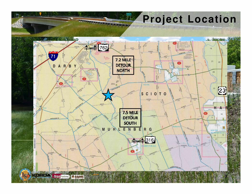
Project Location
762762762762
316316316316
71717171

Background &History
“Gantz Bridge”
• Constructed in 1910
• Two-span Pratt Truss
• Not historic
• 255’ Long, 17.3’ Width
• Closed to traffic in March, 2014
• Deteriorated floor beams
• ADT = 303 vpd (2011)
• 1 of 2 County bridges
over Big Darby
(Florence
Bridge/TR127, c.a.
1912 – closed in
2016)

Project Goals
County Perspective
• Cost effective, “ordinary” construction
• Low maintenance, especially over Big Darby Creek
• Work near Scenic Rivers increasingly difficult
• Avoid future painting of steel girders
• Increase safety – wider structure, realigned roadway
• Aesthetics – County desire and environmental commitment
• Similar aesthetic to other recent long-span County bridges
Scioto River Crossing

Existing Conditions
CR22 – Scioto-Darby Rd.
Dc = 34o
, Site Distance 125’, DS~15 mph
Dc = 25o
, DS~15 mph
Single, 17’ lane
+ 3 vertical curves, DS ≤ 31 mph

Preliminary Engineering
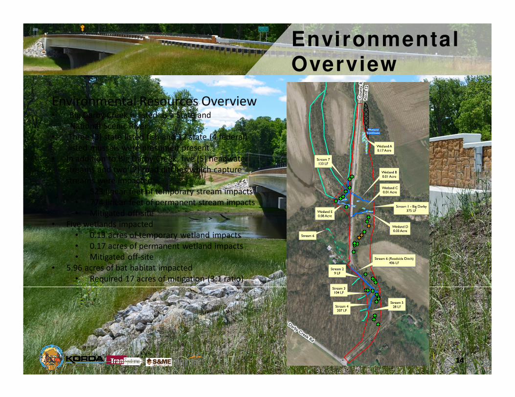
Environmental Resources Overview• Big Darby Creek
• 8 other jurisdictional streams
• 5 wetlands
• Bat roost trees
• Maternity roost trees

Early Stakeholder Meetings
Environmental is key
• Pre-scope meetings with ODOT & agencies
• Numerous on-site meetings
• Weighing each agency’s environmental concerns
• U.S. Fish & Wildlife Service (USFWS)
• ODNR Scenic Rivers
• National Park Service (NPS)
• U.S. Army Corps of Engineers (USACE)
• Ohio EPA – 401 Permits
• ODNR Waterway Permits
• Ohio EPA – Big Darby Stormwater Permit
• The Nature Conservancy (TNC)*
• OSU Ecology Dept.* – Re-introducing mussels upstream
• Field verify OHWM
• Minimize piers in Big Darby Creek for “natural free flow”
• Minimize temporary Big Darby impacts (causeway)
• Minimize permanent impacts to other tributaries
• Minimize Bat tree impacts

Preliminary Engineering
Bridge – Environmental Impact Evaluation

Preliminary Engineering
Feasible Structure Types
• Cost effective, “standard” bridge types
• If on new alignment, make concrete I-beams feasible
• Steel girders vs. concrete I-beams
• Similar initial costs
• Steel life cycle costs +15%
• Future painting over Big Darby Creek
• Wide flange I-beams vs. standard – 20% more strands
• River span – cost effective with no causeway: 2~550 Ton Cranes?

Preliminary Engineering
Hydraulic Considerations
• EX. 2 spans over water vs. PR. 1 span over water + 2 over floodplain
• Open up rear span
• Unregulated “dike”
• HEC-RAS streambed velocity analysis for mussel shear stress

Preliminary Engineering
Final Plan
(add labels, merits, etc)
Dc = 11o
30’,
DS=40 mph
Dc = 9o
45’, DS=44 mph
800’ VC
DS=55mph

Preliminary Engineering
Final Plan
800’ VC, DS=60mph
14
5’
Dc = 9o
45’,
DS=44 mph
Dc = 9o
45’,
DS=44 mph
3-span, 30’ wide bridge
Environmental Overview
Environmental Resources Overview• Big Darby Creek is listed as a State and
National Scenic River
• Three (3) state listed fish and 12 state (4 federal)
listed mussels were presumed present.
• In addition to Big Darby Creek, five (5) headwater
streams and two (2) road ditches which capture
streams were impacted.
• 523 linear feet of temporary stream impacts
• 774 linear feet of permanent stream impacts
• Mitigated off-site
• Five wetlands impacted
• 0.13 acres of temporary wetland impacts
• 0.17 acres of permanent wetland impacts
• Mitigated off-site
• 5.96 acres of bat habitat impacted
• Required 17 acres of mitigation (3:1 ratio)

Environmental Impacts
Mitigation Requirements
• Primary
• 17.14 acres of bat habitat.
• Required for USFWS approval
• Secondary
• Once USFWS approved, need to get concurrence:
• ODNR State Scenic River
• National Park Service-Federal Scenic Rivers
• Ohio EPA (401 and stormwater)
• USACE
• Project mitigation multiple agency collaboration
Environmental Impacts
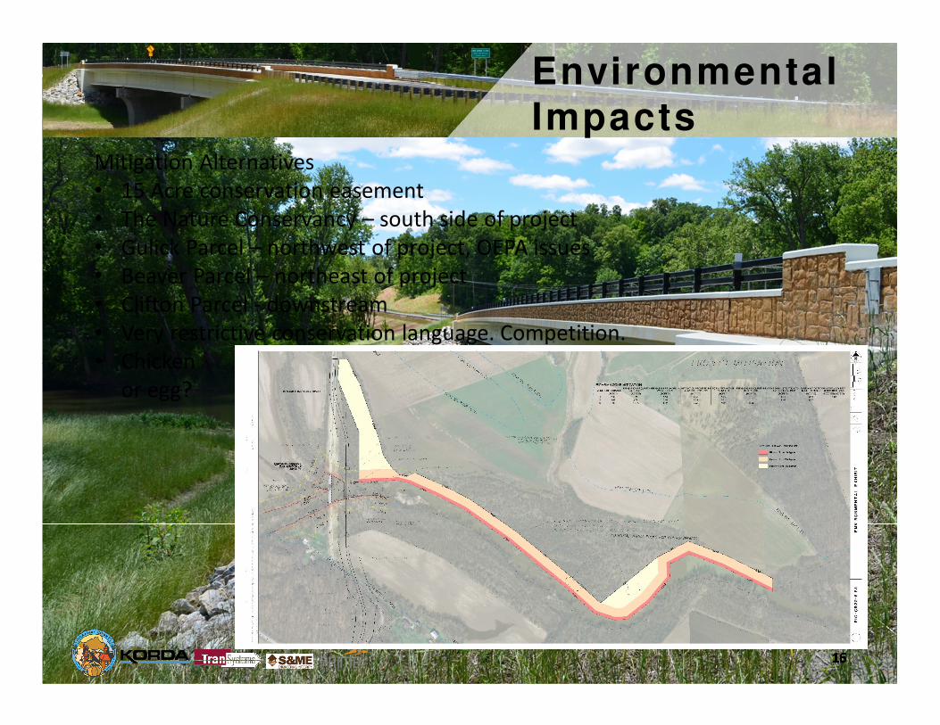
Mitigation Alternatives
• 15 Acre conservation easement
• The Nature Conservancy – south side of project
• Gulick Parcel – northwest of project, OEPA issues
• Beaver Parcel – northeast of project
• Clifton Parcel - downstream
• Very restrictive conservation language. Competition.
• Chicken
or egg?
Environmental Impacts
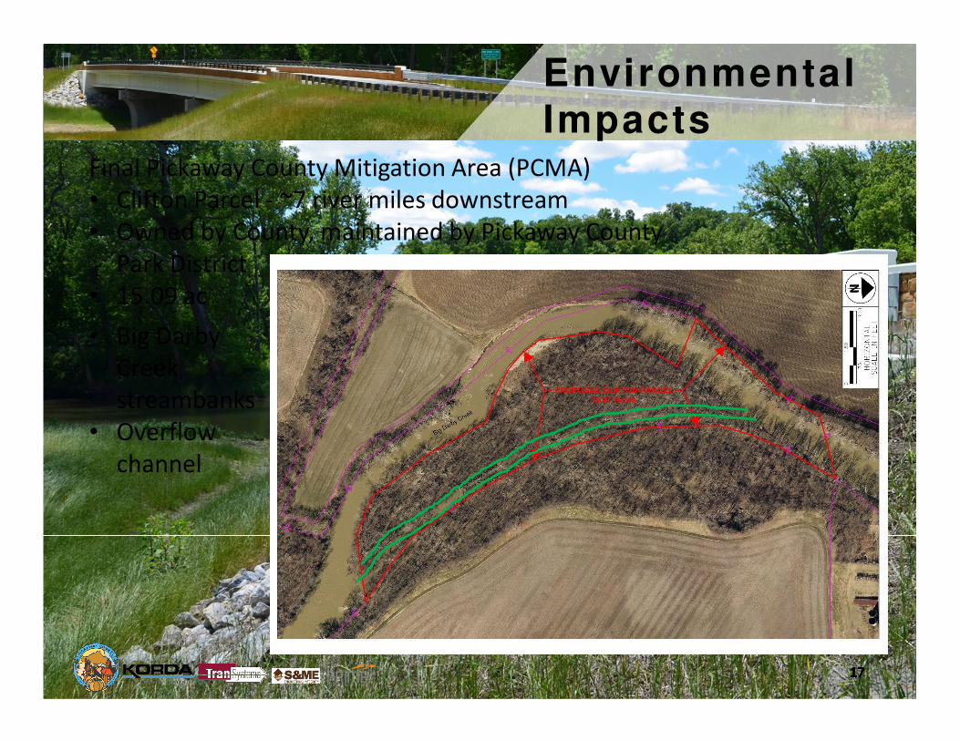
Final Pickaway County Mitigation Area (PCMA)
• Clifton Parcel - ~7 river miles downstream
• Owned by County, maintained by Pickaway County
Park District
• 15.09 ac
• Big Darby
Creek
streambanks
• Overflow
channel

Environmental Path Forward
Environmental Path Forward• Bat Mitigation became critical path to Environmental Clearance
• The proposed mitigation protected and preserved a total 17.14 acres of
riparian/wetland habitat along Big Darby Creek in perpetuity
• Includes 2.05 acres of the existing County Road 22 right of way – re-vegetate
• The Pickaway County Mitigation Area (PCMA/Clifton Parcel)• 15.09 acre riparian habitat located within the active channel and the active
floodplain of the Big Darby Creek.
• Predominately wooded riparian
island adjacent to Big Darby
Creek and separated from the
mainland by a high-flow
channel.
• A small portion of the property
extends across the Darby and
includes a strip of wooded
floodplain on the west bank of
the Big Darby Creek.

Environmental Impacts
Pickaway County Mitigation Area (Clifton Parcel)• Environmental details
• The entire 15.09 acres of the PCMA was considered a special aquatic site.
• Includes varied wetland habitats, vernal pools, intermittent high flow stream channels, and
bottomland riverine forests.
• Possesses the special ecological characteristics of productivity, habitat, and wildlife protection along
this State and National River.
• Preservation of these lands will provide significant ecological benefit to the watershed of the State
Scenic Big Darby Creek by:
• Providing flood control by slowing and absorbing flood waters, resulting in reduced flood
damage, reduced stream bank erosion and increased groundwater storage.
• Providing valuable habitat for threatened and endangered species, including Indiana and
Northern Long-eared bats, Fawnsfoot, Loggerhead Shrike, Northern Riffle Shell, Ohio Pigtoe,
Elephant Ear, Snuffbox, Drummond's Aster and six species of concern to the USFWS and/or
ODNR.

Environmental Impacts
Waterway Permits
• Due to the overall project impacts identified in the Stage 3
plans, the need for a Section 401 Water Quality Certification
and the fact that a 404 Pre-construction Notification and an
404 Individual Permit require the same permit application it
was determined by Transystems and Pickaway County to
prepare a combined Section 404/401 permit application.
• Final Submittal November, 2015
• “Administratively Complete” - January, 2016
• 404 Permit approved by USACE - February, 2016
• Public Hearing - April, 2016
• 401 Permit approved by OEPA - May, 2016

Bridge Design
Piers
• Aesthetic
• Modified wall type vs.
twin tapered columns
• Shafts in-line vs.
rectangular layout
• OHWM constraint
• 54” rock socket
• Limit size & cost
• Designed for complete
scour of overburden (~15’)
Abutments
• Abutments – Turn back on
H-piles to rock

Bridge Design
Concrete I-Beams
• 147’ center span (106’-147’-106’ = 362’), 30’ T/T Parapet
• Wide-flange I-beams - Pre-approval with ODOT and Prestress Association
• 20% more strands
• Later became ODOT standard
• More stable during transport & erection
• Additional vertical reinforcement in anchorage zones for bursting &
confinement
• High strength concrete

Design Details
Roadway Considerations
• Cut/fills ~ 30 ft
• Save trees
• Preserve “levee”
• Drives – up to 320’ long,
20’ fill

Stormwater
Ohio EPA Big Darby Permit• Water Quality - filter strips & biofilters (on-site)
• Riparian Setbacks
• 6.19 acres impacted
• 13.44 acres mitigation required
• 2.12 acres mitigated (on-site)
• 5.0 ac. excess mitigation zones 1+2 (PCMA)
• Groundwater Recharge – negotiate
• Create more groundwater recharge potential
• On-site = 72%. PCMA = 0%. 28% deficit.
• Excess riparian mitigation
• Stream protection
(3750’ Big Darby,
4000’ overflow)
• Wetland recharge >
permit allows
(brush/woods)
• Conservation
corridor

Bidding & Construction
Cost Summary
• Increased engineers estimate as site constraints developed:
• Single prestresser, large shafts, large cranes, anxiety of
environmental limelight, stormwater/SWPPP anxiety.
• Had to be open by winter
• Bids due March 29, 2016 – before 401 permit public hearing
• Awarded to Eagle Bridge Company –
• Bid $4,079,000. Final costs $3,990,000.
• Contract awarded - April 5, 2016 (final 401 permit May 9, 2016)
• Start construction - May 10, 2016
• Open to traffic – December 2, 2016
• Final completion – May 31, 2016

Bidding & Construction
Drilled Shaft Concrete Resolution
• Concrete design strength = 4000 psi (4500 psi spec)
• 28-day breaks = 2987 psi. Assume 10% increase = 3350 psi
• Aligns with 56-day break of 3339 psi
• Adjacent shafts were different pours
• Finite element re-analysis with shafts, footing & piers
• Distribute loads equally among 5 shafts (BDM/RCPier), or,
• Tributary loading (finite element)
• 54” shafts sized for friction resistance – shear in shafts
• Reinforcement based on lateral capacity - deflection/moments
• Development length of #18 bars
• Minimum of 3293 psi required – (just barely vs. 3339)
• Nearest Failure Mode = Scour + Longitudinal Forces (Temp. + Braking + Stream Limit
State)

Lessons Learned
Lessons learned during planning, design,
environmental, construction, etc.
• Early coordination with agencies - develop
relationship
• Constant dialog and feedback
• Rely on team expertise to interpret agency’s
priorities and propose a project & plan that is most
“approvable”
• Keep adjacent landowners/stakeholders updated to
gain buy-in

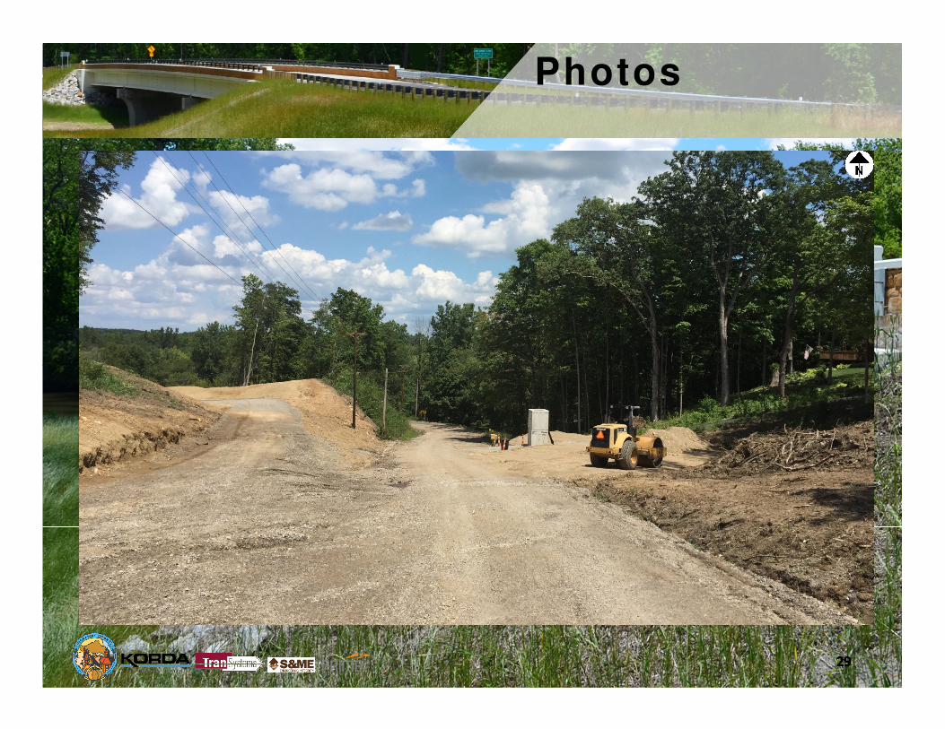
Photos
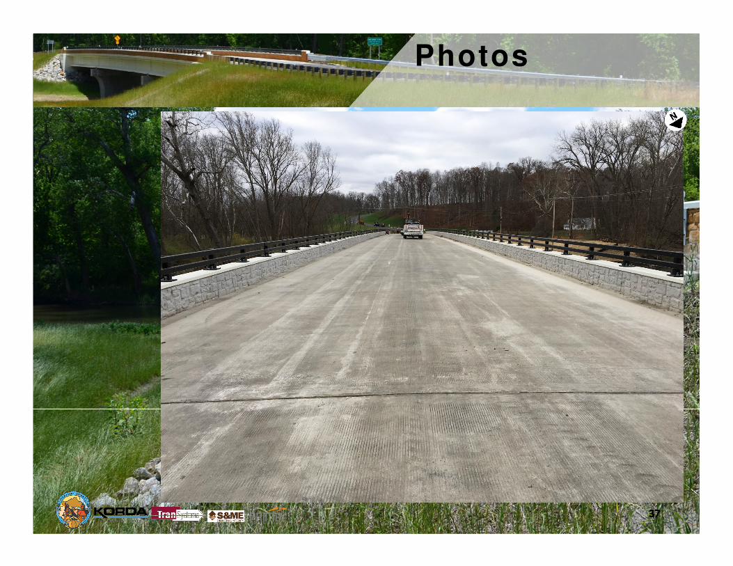
Photos

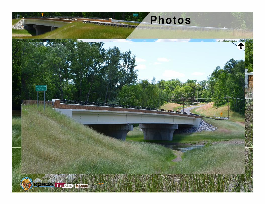
Photos

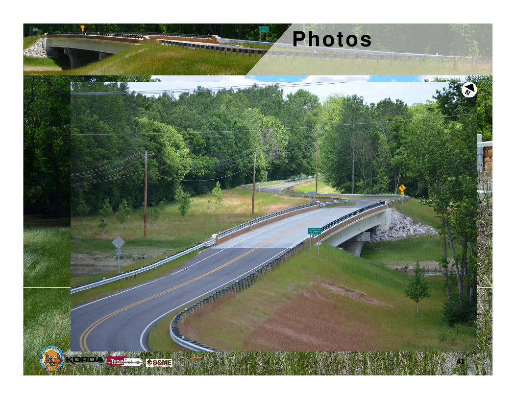
Photos

Photos

Photos

Photos

Photos

Photos
Photos

Photos
Photos

Photos
Photos
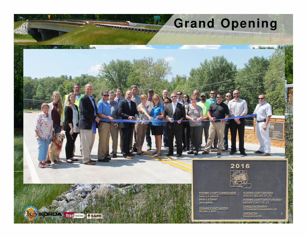
Grand Opening

Questions?


