108
A New Regulatory Regime for the Management of Yukon Placer Mining March 27, 2006 Prepared for Adaptive Management Workshop Whitehorse, Yukon

A New Regulatory Regime for the Management of Yukon Placer Mining
March 27, 2006 Prepared for Adaptive Management Workshop Whitehorse, Yukon

Outline
Proposed Regime – Chronology (3-8)Current Regime VS proposed Regime (9-23)Consultation Plans and TK (24-30)Understanding Placer Mining and Fish (31-40)Watershed Sensitivity and Habitat Suitability Vs Risk (41-51)Compliance and Action Level (52-61)Water Quality; What do we know (62-74)Aquatic Health; What do we know (75-108)

Proposed Regime – Chronology

New Placer Regime Chronology
Dec 2002 - DFO Minister announces elimination of Yukon Placer AuthorizationMay 2003 - Record of Agreement Signed and Steering Committee formed

Record of Agreement May 2003CYFN, Yukon & Canada (DFO)
The new Regime must:
recognize the importance of a sustainable placer industry and the importance of conservation of fish and fish habitat supporting fisheries
be achievable and science-based; incorporate experience and traditional knowledge
be responsive to area and topographical conditions
be ready for implementation by 2007

New Placer Regime Chronology
May 2005 - New Regime Framework Approved by Minister of DFODecember 2005 – Yukon Placer Secretariat established to complete & implement the Regime
Richard Hartmier Photo

Yukon Placer Secretariat - YPSRelationships Diagram
Licensing and Assessing Boards
YWB - YESAB
Public
Joint Placer Implementation
Committee JPIC
Yukon Placer SecretariatYPS
Implementation Management Group
IMG
DFO YG-EMR & Env.
CoreStaff
YG (1)DFO (1)CYFN (1)
Executive DirectorFN & Community LiaisonGIS/DB TechnicianOffice Co-coordinator
Placer Advisory Council
PAC
Mandated BoardsYFWMB–YSC –
RRC (s)
CYFN
First Nations

New Placer Regime Chronology
2006 – Development of draft Regime components – watershed authorizations, monitoring protocols, incorporation of Traditional Knowledge2006/2007 – Three phase consultation process2007 – Implementation of new Regime
Richard Hartmier Photo

Current Regime VS proposed Regime

Placer Activities
Land
Socio Economic
Water
Fish
Mining Land Use Operating Plan
Water Use License
Yukon Placer Authorization
EXISTING PROCESS
Impa
ct A
sses
smen
tT
hrou
gh Y
ESA
A

Yukon Placer Authorization (1993)
Identified end-of-pipe sediment standards for placer mining operations
Stream classification based on presence and absence of fishType I - salmon & trout spawning streams (no impact)Type II - salmon rearing streamsType III - fish species of social/cultural/economic significance and important to biodiversityType IV
IV(a) - other streams with fishIV(b) - other streams, no fish
Type V - unclassified

Current YPA – The Challenges
Stream classification based on presence or absence of fish
Many factors determine fish distribution - e.g. population or year class strength, changing environmental conditionsDifficult to change stream classifications when fish informationchanges
Sediment discharge standards provide certainty for miners and inspectors

Current YPA – The Challenges
Sediment loading and sediment levels in the environment (i.e. water quality objectives) more important for fish
Deferrals – water quality and physical
Uncertainty how fisheries and stream productivity and health (diversity) affected by miningUncertainty how long recovery takes after mining ceases
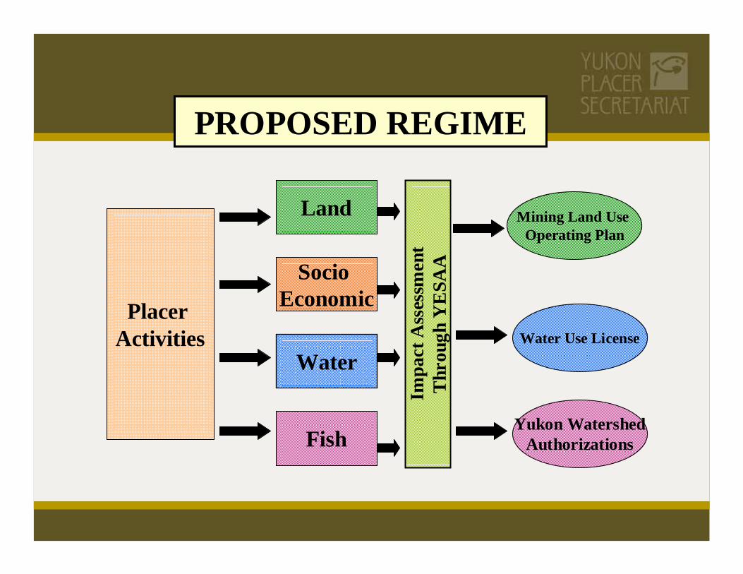
PROPOSED REGIME
Placer Activities
Land
Socio Economic
Water
Fish
Mining Land Use Operating Plan
Water Use License
Yukon WatershedAuthorizations
Impa
ct A
sses
smen
tT
hrou
gh Y
ESA
A

PROPOSED REGIME
Regulatory Framework
Adaptive ManagementFramework
Placer Activities
Land
Socio Economic
Water
Fish
Mining Land Use Operating Plan
Water Use License
Yukon WatershedAuthorizations
Impa
ct A
sses
smen
tT
hrou
gh Y
ESA
A

Regulatory FrameworkRisk Based Approach Watershed Based Compliance, Monitoring
& Enforcement
Adaptive Management Framework
PROPOSED REGIME
Effects on
Industry
Assess ProblemAdjust Design Evaluate Implement
Monitor
PlacerActivi-
ties
Land
Socio Economic
Water
Fish
MLUOP
WUL
YWA
YE
SAA
Effects on
WatershedHealth

What is the proposed Placer Regime?
A management & regulatory framework
Addresses the effects of placer mining activities on fish and fish habitat under the federal Fisheries Act.
Does not deal with effects of hard rock mining
Does not apply to wildlife or land use Richard Hartmier Photo
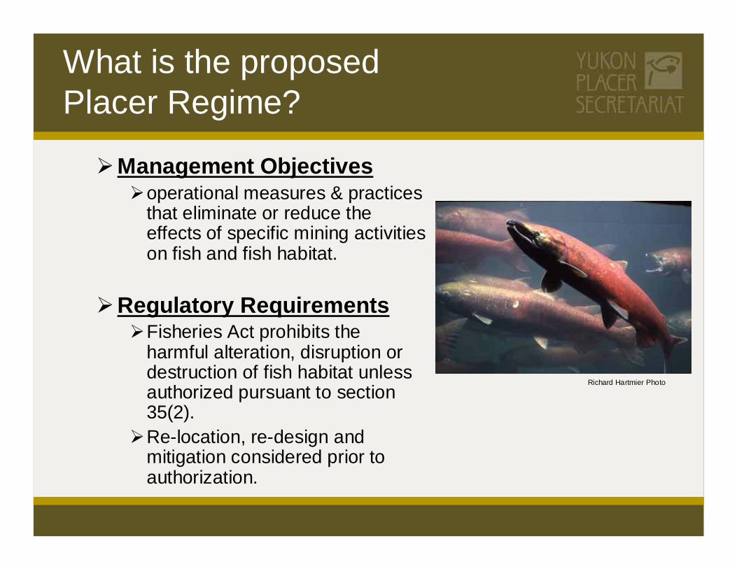
Management Objectivesoperational measures & practices that eliminate or reduce the effects of specific mining activities on fish and fish habitat.
Regulatory RequirementsFisheries Act prohibits the harmful alteration, disruption or destruction of fish habitat unless authorized pursuant to section 35(2). Re-location, re-design and mitigation considered prior to authorization.
Richard Hartmier Photo
What is the proposed Placer Regime?

The Regime principles are basedon an understanding of:
Where placer gold is found
How placer mining recovers gold
How mining activities can effect fish and fish habitat
The biology of fish species and aquatic organisms
Ecological processes that are part of a healthy aquatic system

Key Positive Aspects of proposed Regime
Watershed health approach based on diversity and abundance of benthic invertebrates and fish.
Habitat classification based on habitat suitability instead of presence/absence of fish.
Emphasis on instream water quality objectives instead of only end-of-pipe mine effluents.

Key Positive Aspects of proposed Regime
Risk assessment and management of water quality objectives and discharge standards based on sensitivity of habitat and severity of impact of placer activity.
Action level approach to enforcement and compliance of discharge standards.
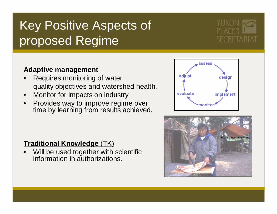
Key Positive Aspects of proposed Regime
Adaptive management• Requires monitoring of water
quality objectives and watershed health.• Monitor for impacts on industry• Provides way to improve regime over
time by learning from results achieved.
Traditional Knowledge (TK)• Will be used together with scientific
information in authorizations.
Richard Hartmier Photo

Benefits of proposed Regime
Tailored to unique Yukon environmentImproved aquatic healthProtection for fish & fish habitatGreater certainty for industryIncorporates Traditional KnowledgeTransparent & integrated approachClear standards & rulesAdaptive ManagementIntegrated resource management including YG, DFO & CYFN
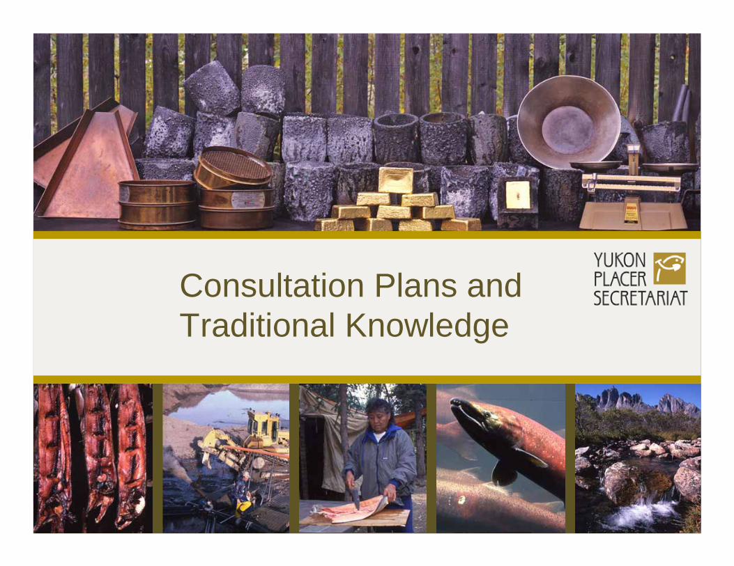
Consultation Plans and Traditional Knowledge

Consultation Plans
Objectives
Provide information about differences between current YPA & proposed RegimeProvide opportunities for comment on Regime before implementationEnsure placer industry is informed & can comment on Regime’s effects on their operations

Consultation Plans
Who will be consulted?
First NationsMandated BoardsStakeholdersPublic and Communities

Past First Nation Involvement
CYFN a signatory to Record of Agreement Member of Implementation Steering CommitteeRepresented on Working Group which developed the Regime framework
Info sessions on Traditional Knowledge hosted by CYFN Jan 2004 & Mar 2005Yukon First Nations receive general briefing on proposed regime July 2004Nacho Nyak Dun - separate briefing on request Sept 2004Industry briefing in Dawson attended by Dawson RRC repBriefing with Yukon Salmon Committee & Yukon Fish & Wildlife Management Board May/June 2005

Consultation Plans
Three-Step Process
Phase 1 – Information – Mar-June 2006Present key concepts & information
Phase 2 – Consultation – Sept-Dec 2006Gather input on proposed Regime
Phase 3 – Final Review – Mar-May 2007Review how feedback has been incorporatedFinal opportunity for input

Traditional Knowledge (TK)Will be used together with scientific & local information in authorizations
Secretariat proposes to gather TK with assistance & direction from First Nations
Introductory meetings held in February/March with all Yukon First Nations to discuss consultation & gathering of TK

Traditional KnowledgeSecretariat proposal to Gather TK
Adapt to suit each First Nation needsFirst Nation to identify TK-holdersSchedule meetings on TK in each communityAt meetings:
Secretariat provides briefing on Regime & draft authorizationSecretariat requests TK input for authorization

Understanding Placer Mining and effects on Fish
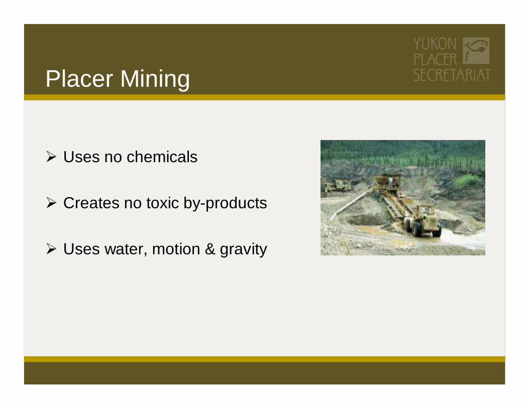
Placer Mining
Uses no chemicals
Creates no toxic by-products
Uses water, motion & gravity

www.painetworks.com
Placer Operations

What is Placer Gold?Pieces of gold (flakes, nuggets) which eroded from hardrock and were carried downstream by streams and rivers.
Deposited in stream and river valleys when currents slow down and are no longer strong enough to suspend the gold, which is heavy, in water.
Over thousands of years streams and rivers changed course, and valleys filled up with sediments, including placer gold deposits.
The heavy placer gold migrates downward through the sediments and is concentrated at the bedrock level, often covered by 50 feet or more of sediments.

How does Placer Mining Recover Placer Gold?
Sediments and gravels covering the “pay dirt” above the bedrock are removed.Placer gold is recovered by “sluicing” the gravels, i.e. gravels are processed by washing in flowing water, with the heaviest particles (gold) settling out.The sluicing process uses water to wash away fine materials from the gold particles, often resulting in high concentrations of sediment within the waste water.
Richard Hartmier Photo

How does Placer Mining Recover Placer Gold?
Settling ponds are used to settle out the sediments before the water is discharged back into the stream. Some mines recycle the water for more sluicing.To get at pay dirt underneath streams and rivers, the stream or river may need to be diverted while mining.

What Placer Mining Activities Can Affect Fish & Fish Habitat?
Water use - for sluicingSediment discharges - from sluicingStream diversions - to get at pay dirt underneath streamsOther Instream Activities - Construction of dams, dikes, settling
ponds, etc.

Effects of Stress on FishReproduction - may be irregular or absent.
Growth - may be reduced.
Body Condition – may be reduced.
Survival - stress can result in direct or indirect mortality.

How is Reproduction Different between Salmon and Grayling?
Salmonspawn once in their lifetime in very specialized
habitat, expending all their energy and life in this effort.
produce relatively few but large eggs which they deposit in carefully prepared redds in fall when water runs very clear.
eggs incubate in gravels for 6 or 7 months and hatch in late winter or spring.
fry hatch with large yolk sacs which provide nourishment for weeks. Young salmon reside in fresh water for weeks, months or years prior to migrating out to sea. Suitable feeding and rearing habitat is critical during this time.
www.magazine.audubon.org
www.premiermountainlodge.com
magazine.audobon.org

Graylingspawn multiple times in lifetime with less
specialized spawning habitat requirements.produce relatively small eggs in the spring
which are broadcast over a variety of habitat types and areas.
eggs incubate in 2 to 3 weeks and hatch in late spring.
fry have small yolk sacs, poorer swimming ability and are dependent on water currents to carry them into warmer water areas with sufficient food in spring for them to survive and grow to a size where they can swim and actively seek out rearing habitats.
How is Reproduction Different between Salmon and Grayling?

Watershed Sensitivity and Habitat Suitability Vs Risk
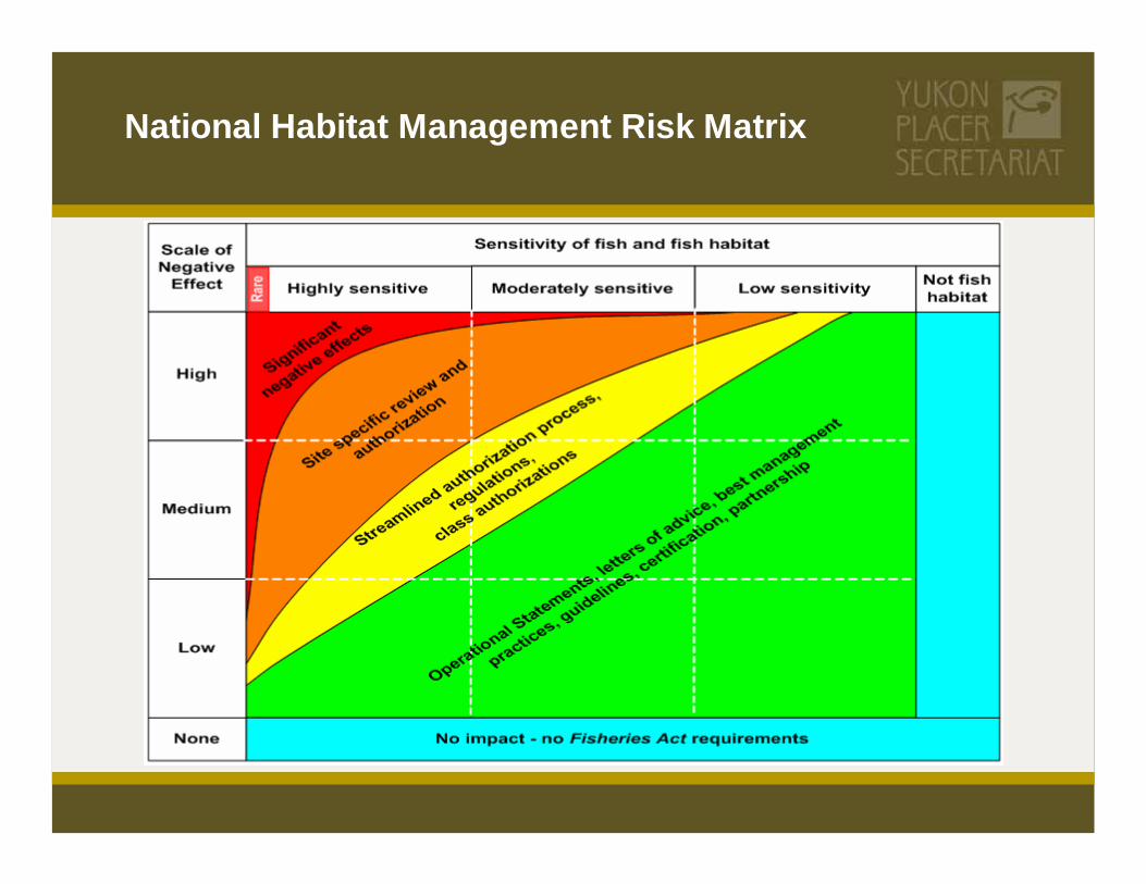
National Habitat Management Risk Matrix
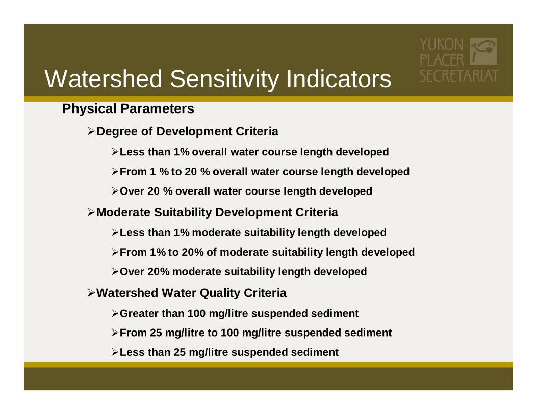
Physical ParametersDegree of Development Criteria
Less than 1% overall water course length developed
From 1 % to 20 % overall water course length developed
Over 20 % overall water course length developed
Moderate Suitability Development CriteriaLess than 1% moderate suitability length developed
From 1% to 20% of moderate suitability length developed
Over 20% moderate suitability length developed
Watershed Water Quality CriteriaGreater than 100 mg/litre suspended sediment
From 25 mg/litre to 100 mg/litre suspended sediment
Less than 25 mg/litre suspended sediment
Watershed Sensitivity Indicators

Watershed Sensitivity Indicators
Biological Parameters Adult Salmon Distribution Criteria
No known salmon spawning areas or adult salmon presence
Historic salmon spawning areas, not current
Likely salmon spawning areas, no verified presence
Known salmon spawning areas, limited distribution
Known salmon spawning areas, broad distribution
Richard Hartmier Photo
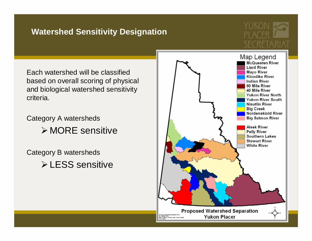
Watershed Sensitivity Designation
Each watershed will be classified based on overall scoring of physical and biological watershed sensitivity criteria.
Category A watersheds
MORE sensitive
Category B watersheds
LESS sensitive

Habitat Suitability Indicators
Physical Parameters
Water Course Gradient
0% to 1.5%
1.51% to 3.5%
3.51% to 5%
over 5%
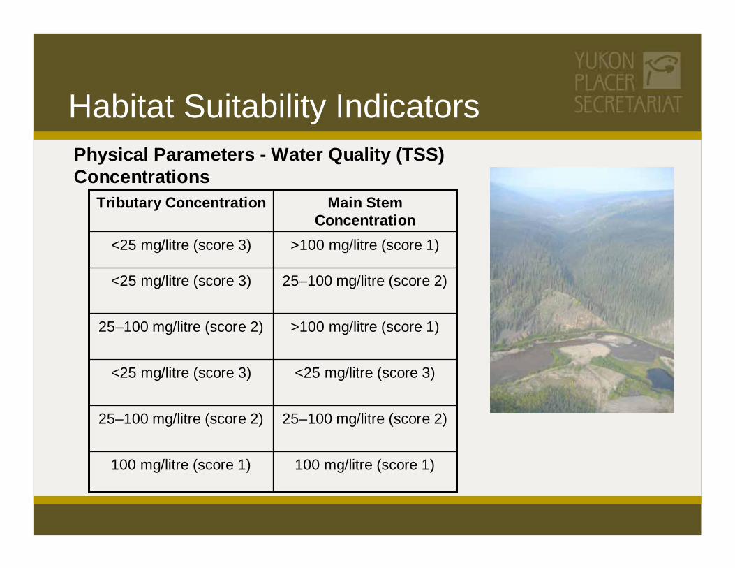
Habitat Suitability IndicatorsPhysical Parameters - Water Quality (TSS) Concentrations
100 mg/litre (score 1)100 mg/litre (score 1)
25–100 mg/litre (score 2)25–100 mg/litre (score 2)
<25 mg/litre (score 3)<25 mg/litre (score 3)
>100 mg/litre (score 1)25–100 mg/litre (score 2)
25–100 mg/litre (score 2)<25 mg/litre (score 3)
>100 mg/litre (score 1)<25 mg/litre (score 3)
Main Stem Concentration
Tributary Concentration

Habitat Suitability Indicators
Biological ParametersKnown salmon spawning areas/special management zones
Proximity to juvenile production areas
0.0 to 5.0 km5.01 to 35.0 km35.0 to 70.0 kmMore than 70.0 km
Richard Hartmier Photo
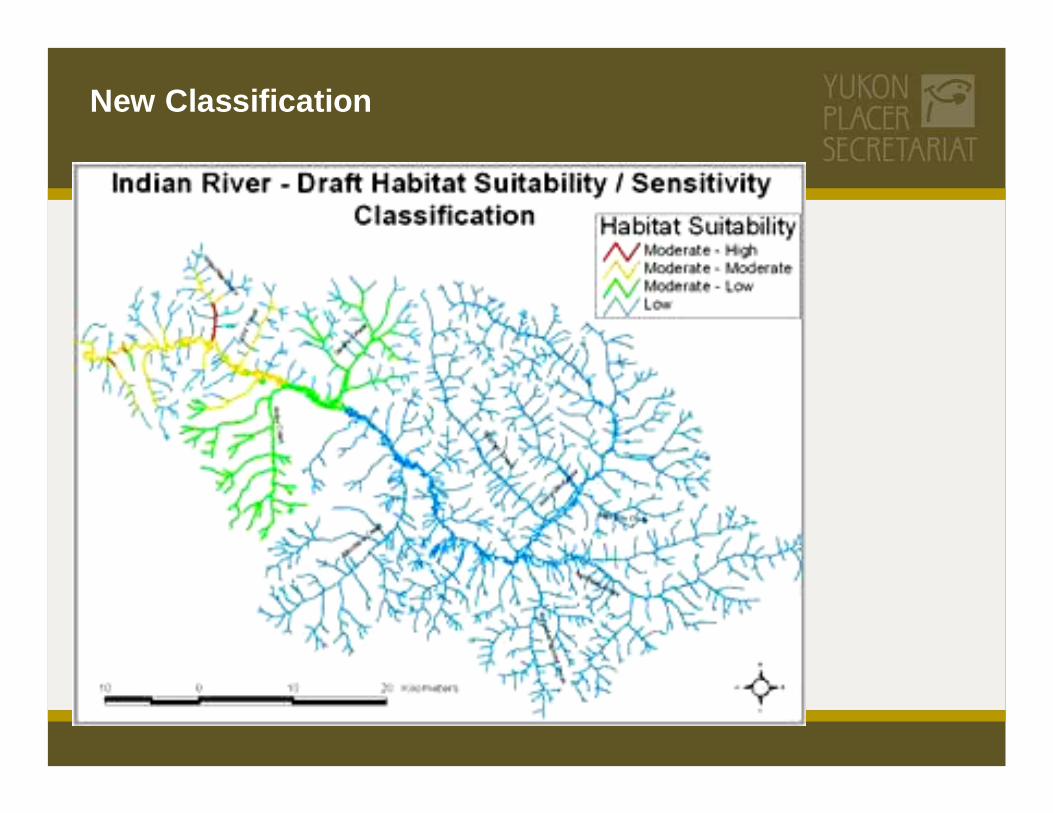
New Classification
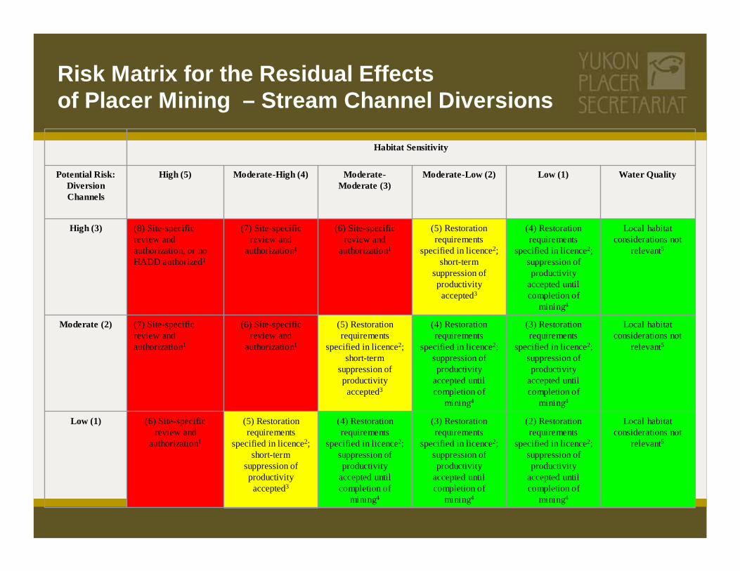
Risk Matrix for the Residual Effects of Placer Mining – Stream Channel Diversions
Local habitat considerations not
relevant5
(2) Restoration requirements
specified in licence2; suppression of productivity
accepted until completion of
mining4
(3) Restoration requirements
specified in licence2; suppression of productivity
accepted until completion of
mining4
(4) Restoration requirements
specified in licence2; suppression of productivity
accepted until completion of
mining4
(5) Restoration requirements
specified in licence2; short-term
suppression of productivity accepted3
(6) Site-specific review and
authorization1
Low (1)
Local habitat considerations not
relevant5
(3) Restoration requirements
specified in licence2; suppression of productivity
accepted until completion of
mining4
(4) Restoration requirements
specified in licence2; suppression of productivity
accepted until completion of
mining4
(5) Restoration requirements
specified in licence2; short-term
suppression of productivity accepted3
(6) Site-specific review and
authorization1
(7) Site-specific review and authorization1
Moderate (2)
Local habitat considerations not
relevant5
(4) Restoration requirements
specified in licence2; suppression of productivity
accepted until completion of
mining4
(5) Restoration requirements
specified in licence2; short-term
suppression of productivity accepted3
(6) Site-specific review and
authorization1
(7) Site-specific review and
authorization1
(8) Site-specific review and authorization, or no HADD authorized1e
High (3)
Water Quality Low (1)Moderate-Low (2)Moderate-Moderate (3)
Moderate-High (4)High (5)Potential Risk: Diversion Channels
Habitat Sensitivity

Potential Severity of Effects Table for the Residual Effects of Placer Mining – Stream Channel Diversions
SatisfactoryFewNoneHabitat features
Stable materialEasily eroded, fine materialPermafrostMaterial channel is constructed in
< 100 m> 100 m < 1 km.> 1 kmLength of diversion channel
Lowest point in valleyConfinedPerchedLocation of diversion channel
> 10 years [stable, well-designed, permanent (“final restoration channel”)]
2 to 10 years (stable, well-designed, some potential for fish utilization)
< 2 years (i.e., little opportunity for return to productivity)
Duration diversion channel is in place
> 1:5 year1:2 year to 1:5 year< 1:2 year Return period used for channel design (flood flows)
Low Risk (Score 1)Moderate Risk (Score 2)High Risk (Score 3)Physical Disruption: Diversion Channels

Compliance and Action Level

Compliance enforcementROUTINE INSPECTIONS are conducted by Natural Resource Officers/Mining employed by EM&R.
BEFORE APRIL 1, 2003 inspection and enforcement activities were governed by an MoU between DIAND, DFO and DoE. A protocol to replace this MoU has been formalized by EM&R and DFO.
NATURAL RESOURCE OFFICERS (mining inspectors) perform their duties within a framework of Education, Encouragement, and Enforcement.

Compliance enforcement
EDUCATION is served in many ways, including a dialogue prior to permitting.
Inspectors always explain a new licence to operators, stressing the obligations and ensuring the requirements are understood.Operators are encouraged to ask questions, and inspectors make providing information and clarification a high priority.

Compliance enforcement
ENCOURAGEMENT takes many forms, and includes:
Timely remindersReadiness to acknowledge a job well-doneShowing understanding of an operator’s aims and working conditionsInvolving operators in decisions that affect themMaintaining an effective field presence
Compliance enforcement
ENFORCEMENT activities include:
Inspection and monitoring to verify complianceVerbal or written warningsWarning ticketsDirections to perform remedial measuresInvestigations of serious violationsProsecution

Action Level Approach
The Action Level approach recognizes:The reliable and effective interaction between inspector and operatorThe prevalence of settling facilities designed to discharge sediment in concentrations significantly lower than required by the current regulatory regime
Richard Hartmier Photo

Definitions
Design Target: the best settling facility that can be established at a placer mining operation, given the prevailing site characteristics
Action Level: the end-of-pipe sediment concentrations that must not be exceeded --on average-- for the life of the mining operation
Compliance Level: a maximum end-of-pipe concentration that must never be exceeded

Application of Action Level
SETTLING POND PERFORMANCE
0.0
0.5
1.0
1.5
2.0
2.5
3.0
3.5
4.0
0 5 10 15 20 25 30 35Days
Con
cent
ratio
n (m
l/L)

Water Quality Objectives and Sediment Discharge StandardsWatersheds of Higher Sensitivity
Standard to meet downstream Water Quality16NoneNo Fish8FieldWater Quality
Design Target: 0.2 ml/L12
Action Level: 1.0 ml/LCompliance Level: 1.5 ml/L
< 200 mg/LRearing Other Low7Tier 33Low
Design Target: 0.2 ml/L12
Action Level:13 0.8 ml/L15
Compliance Level:14 1.2 ml/L< 80 mg/L
Rearing CH Low
Rearing Other High6
Tier 2Moderate-L
< 200 mg/L< 50 mg/LRearing CH5
ModerateTier 2Moderate-M
< 200 mg/L11< 25 mg/LRearing CH5
HighTier 22Moderate-H
0 mg/L10< 25 mg/LSalmonidspawning4Tier 11High
Sediment Discharge StandardWQO9DescriptionSensitivity Indicators
Habitat Sensitivity

Water Quality Objectives and Sediment Discharge StandardsWatersheds of Lower Sensitivity
Standard to meet downstream Water Quality16NoneNo Fish8FieldWater Quality
Design Target: 0.2 ml/L12
Action Level: 1.0 ml/LCompliance Level: 2.5 ml/L18
< 300 mg/LRearing Other Low7Tier 33Low
Design Target: 0.2 ml/L12
Action Level: 1.0 ml/LCompliance Level: 2.0 ml/L17
< 200 mg/L
Rearing CH Low
Rearing Other High6
Tier 2Moderate-L
Design Target: 0.2 ml/L12
Action Level:13 0.4 ml/L15
Compliance Level:14 0.8 ml/L< 100 mg/LRearing CH5
ModerateTier 2Moderate-M
< 200 mg/L11< 25 mg/LRearing CH5
HighTier 22Moderate-H
0 mg/L10< 25 mg/LSalmonidspawning4Tier 11High
Sediment Discharge StandardWQO9DescriptionSensitivity Indicators
Habitat Sensitivity
Water Quality;What do we know ?

Water Quality Monitoring Participants
CS&I Staff
All Inspectors, 3 Research Staff, 2 Lab Assistants
YG Water Resources
DFO
SAMPLING 2004
Geology, 18, 2%
DFO, 14, 2% Research, 133, 16%
Inspections, 505, 59%
Blitz, 176, 21%
TOTAL SAMPLES
846

SAMPLING 2005
DFO, 49, 3%
Inspections, 442, 30%
Blitz, 161, 11%
Geology, 38, 3%
Research, 790, 53%
TOTAL SAMPLES
1513


y = 4E-16x5 - 3E-12x4 + 7E-09x3 - 8E-06x2 + 0.0051x - 0.6727R2 = 0.9922
0.0
0.5
1.0
1.5
2.0
2.5
3.0
3.5
4.0
0 500 1000 1500 2000 2500 3000
Suspended Solids (mg/L)
Setle
able
Sol
ids
(ml/L
)
Suspended Solids VS Settleable Solids for Green Gulch, #76 (2004, with Trendline)
Projects On The GoMAKING SENSE OF LAST YEARS DATA
ANALYZING, COMPILING, MAPPING, OVER 1500 SAMPLES COLLECTED IN 2005
GRAIN SIZE ANALYSIS OF OVER 175 SEDIMENT SAMPLES COLLECTED LAST YEARUSING THE 300+ FLOW MEASUREMENTS COLLECTED TO CALCULATE STREAM LOADINGDIGITIZING ALL OF THE LAB ANALYSIS FROM 1982 ON INTO A WQ DATA BASETSS vs SETTLEABLE CORRELATIONS OF OVER 450 SILT CLAY SAMPLES COLLECTED SINCE 2003
Watersheds2006
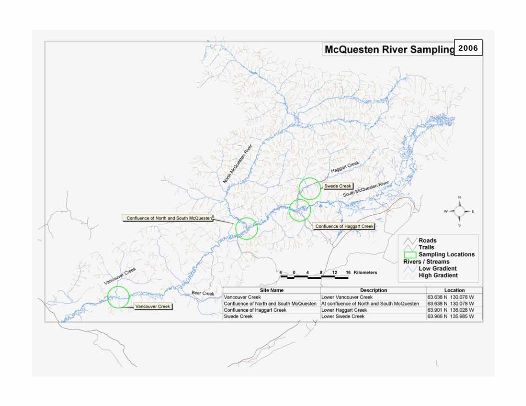
INDIAN RIVERKLONDIKE RIVERMcQUESTEN RIVER60 MILE RIVER
THESE ARE THE PRIMARY TARGET WATERSHEDS FOR 2006
2007
MAYO RIVERYUKON RIVER NORTHYUKON RIVER SOUTHWHITE RIVER
THESE ARE THE SECONDARY TARGET WATERSHEDS FOR 2006, PRIMARY FOR 2007
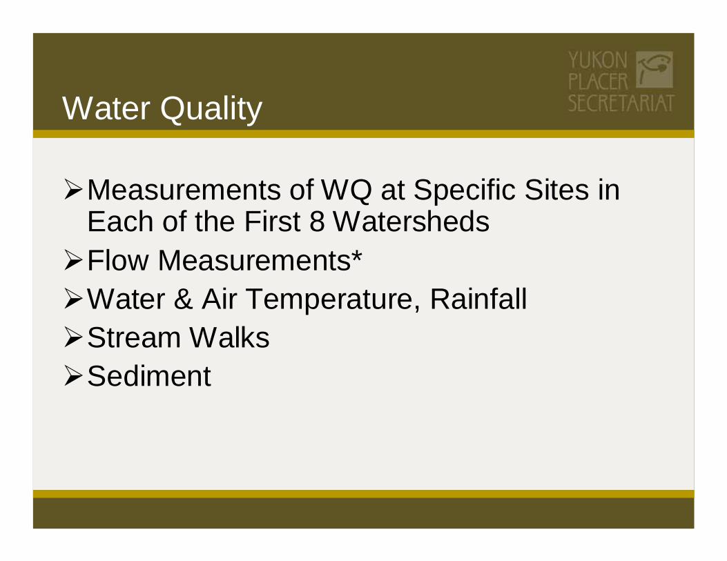
Water Quality
Measurements of WQ at Specific Sites in Each of the First 8 WatershedsFlow Measurements*Water & Air Temperature, RainfallStream WalksSediment

71
2006

72
2006

73
2006
74
2006
Aquatic Health;What do we know ?
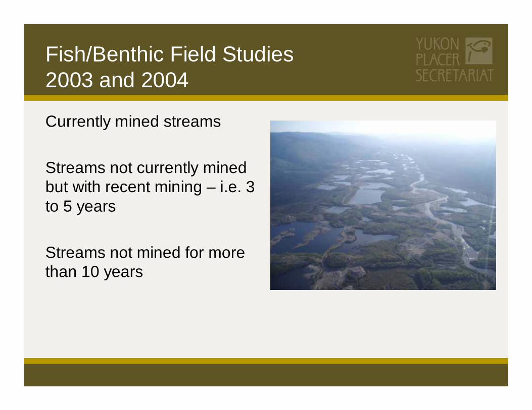
Fish/Benthic Field Studies 2003 and 2004
Currently mined streams
Streams not currently mined but with recent mining – i.e. 3 to 5 years
Streams not mined for more than 10 years

Fish/Benthic Studies 2003 and 2004
Possible Category A Watersheds
Klondike RiverMcQuesten River
Possible Category B Watersheds
Indian RiverSixty Mile River

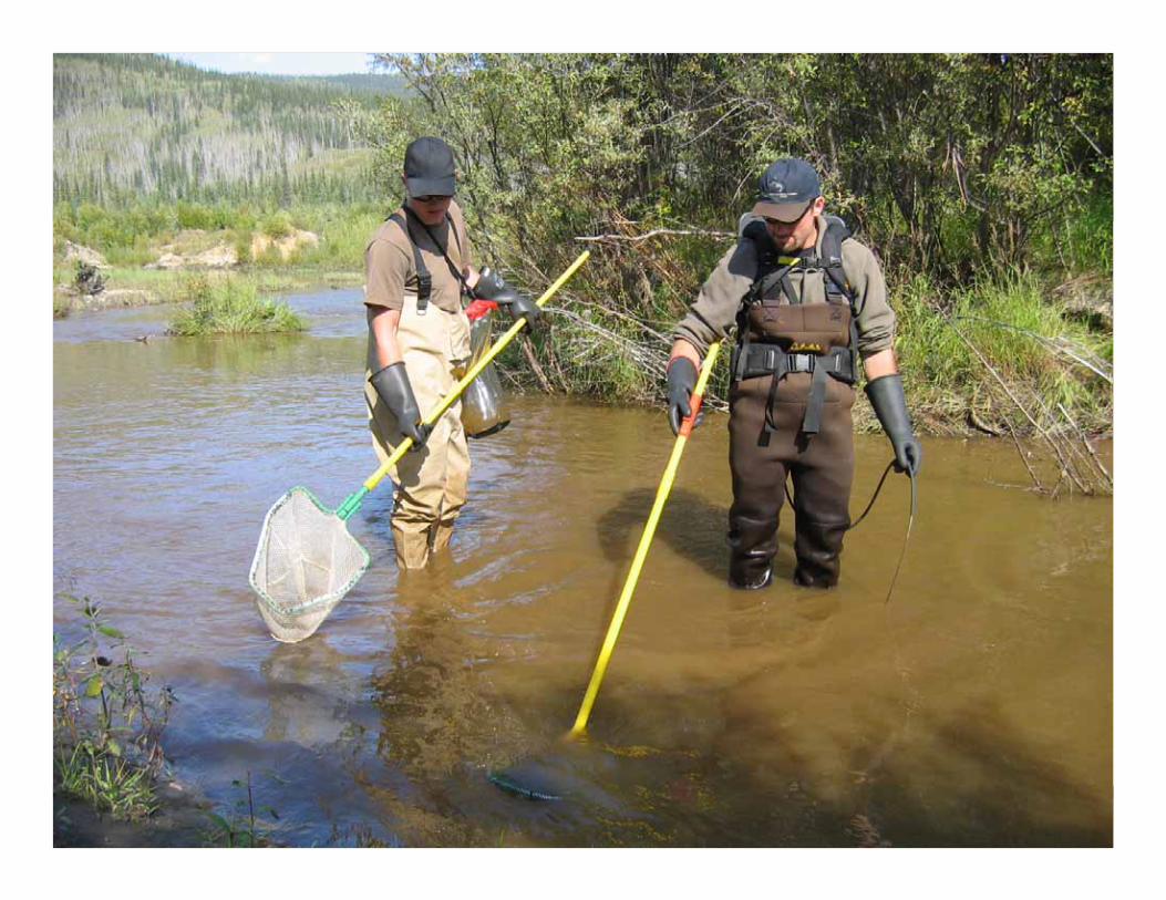
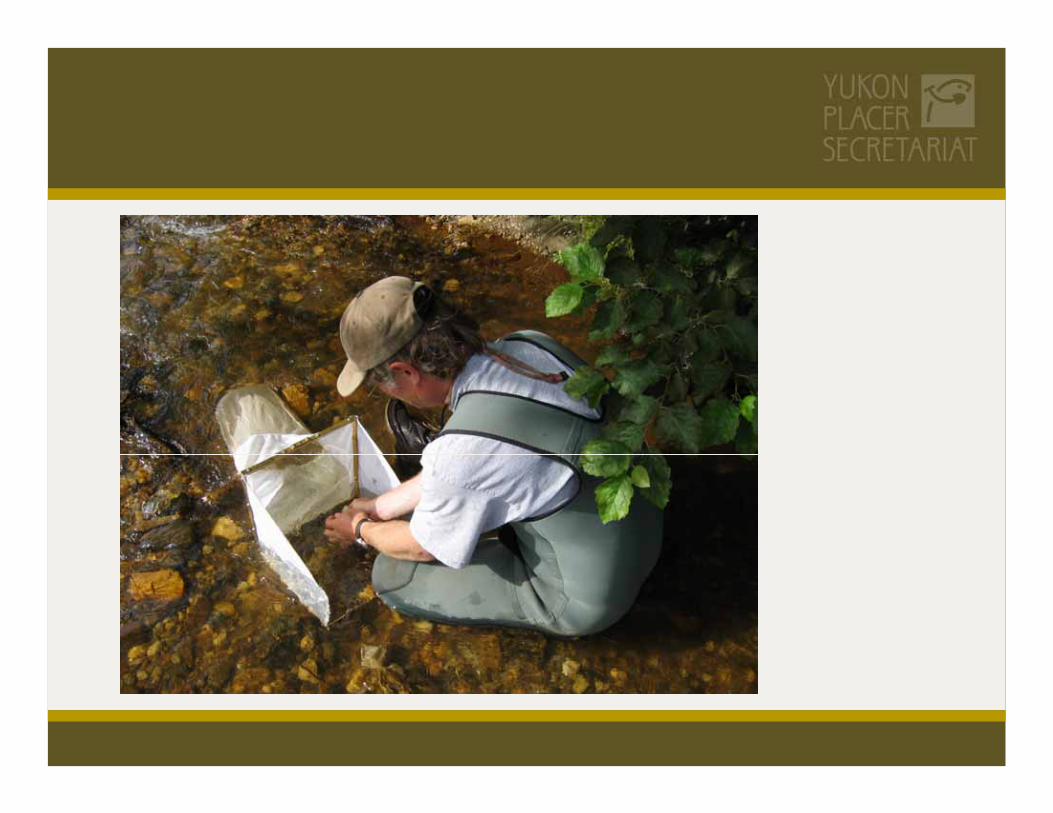
Sampling Methods


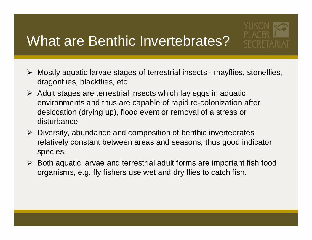
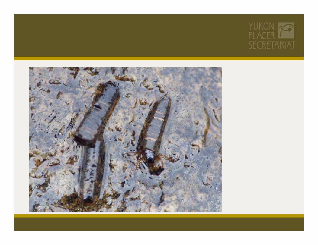
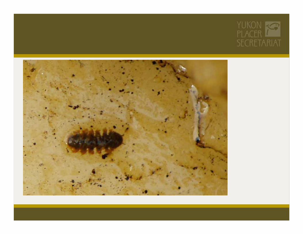
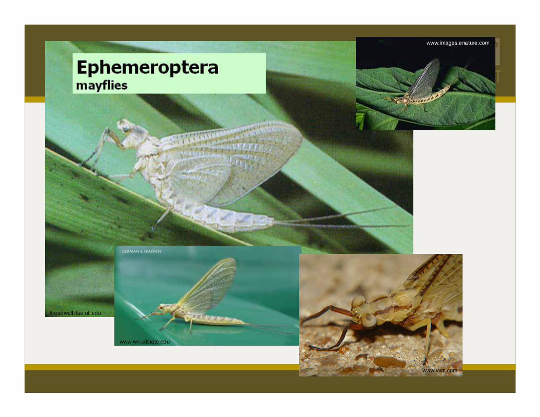
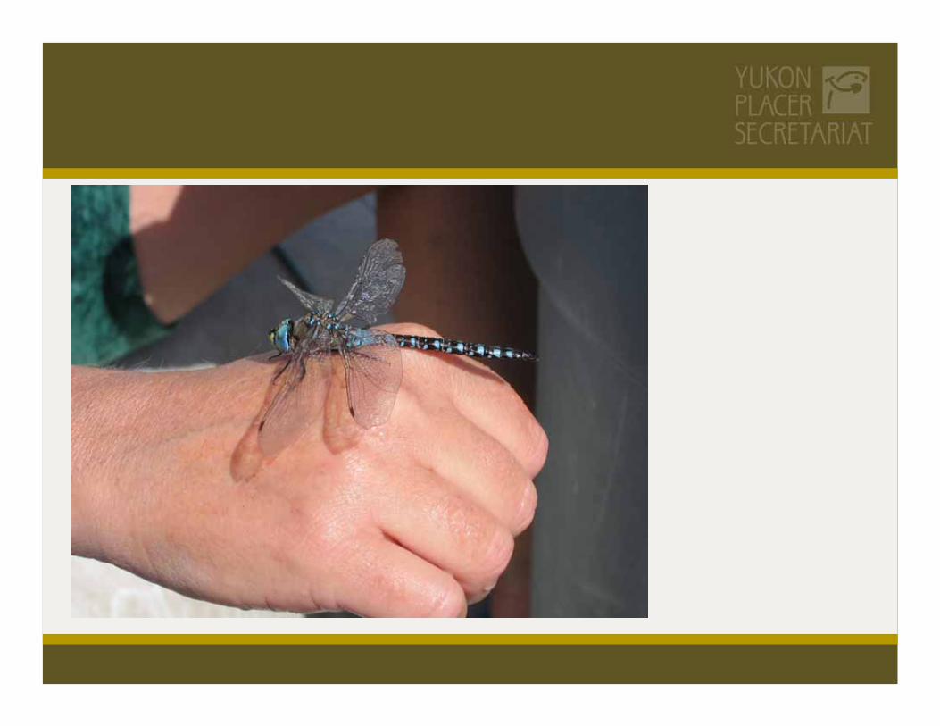
What are Benthic Invertebrates?
Mostly aquatic larvae stages of terrestrial insects - mayflies, stoneflies, dragonflies, blackflies, etc.Adult stages are terrestrial insects which lay eggs in aquatic environments and thus are capable of rapid re-colonization after desiccation (drying up), flood event or removal of a stress or disturbance.Diversity, abundance and composition of benthic invertebrates relatively constant between areas and seasons, thus good indicator species.Both aquatic larvae and terrestrial adult forms are important fish food organisms, e.g. fly fishers use wet and dry flies to catch fish.

Why are Benthic Invertebrates Important to the Regime?
They are the key food organism for juvenile salmon, and both adult and juvenile freshwater fish.
They are the main indicator organisms for water quality and aquatic environment health and productivity in terms of:
diversity (health - number of species groups represented)abundance (productivity - amount of each group)quality (health and productivity - more environmentally sensitive species groups and more important fish food species groups)

ltreadwell.ifas.ufl.edu
www.usask.ca/biology
www.encarta.msn.com


ltreadwell.ifas.ufl.edu
www.wri.sdstate.edu
www.vvm.com
www.images.enature.com
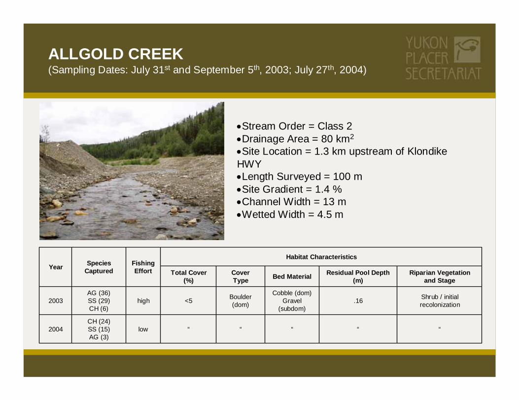
ALLGOLD CREEK(Sampling Dates: July 31st and September 5th, 2003; July 27th, 2004)
•Stream Order = Class 2•Drainage Area = 80 km2
•Site Location = 1.3 km upstream of Klondike HWY•Length Surveyed = 100 m•Site Gradient = 1.4 %•Channel Width = 13 m•Wetted Width = 4.5 m
Shrub / initial recolonization.16
Cobble (dom)Gravel
(subdom)
Boulder (dom)<5high
AG (36)SS (29)CH (6)
2003
“““““lowCH (24)SS (15)AG (3)
2004
Riparian Vegetationand Stage
Residual Pool Depth (m)Bed MaterialCover
TypeTotal Cover
(%)
Habitat CharacteristicsFishingEffort
Species CapturedYear

BONANZA CREEK(Sampling Date: September 11th, 2003; July 27th, 2004)
•Stream Order = Class 3•Drainage Area = 250 km2
•Site Location = kilometre 2 Bonanza Creek Road•Length Surveyed = 100 m•Site Gradient = .5 %•Channel Width = 13.5•Wetted Width = 10.5
Young Mixed Forest.60
fines (dom)gravel
(subdom)
Deep Pool (dom)Overhanging Vegetation
(subdom)> 20low
SS (21)AG (1)CH (1)
2003
“““““medium
CH (52)SS (5)
LNS (3)BB (1)
2004
Riparian Vegetationand Stage
Residual Pool Depth (m)Bed MaterialCover
TypeTotal Cover
(%)
Habitat Characteristics
FishingEffort
Species CapturedYear

CLEAR CREEK(Sampling Date: July 31st, 2003)
•Stream Order = Class 3•Drainage Area = 600 km2
•Site Location = upstream Klondike HWY•Length Surveyed = 100 m•Site Gradient = .2 %•Channel Width = 17 m•WettedWidth=22m
Shrub / Young Mixed Forest.54
Cobble (dom)Gravel and fines
(subdom)
Overhanging Vegetation (dom)
Deep Pool (subdom)10 to 20medium
AG (23)SS (9)CH (1)
2003
Riparian Vegetationand Stage
Residual Pool Depth (m)Bed MaterialCover
TypeTotal Cover
(%)
Habitat CharacteristicsFishingEffort
Species CapturedYear
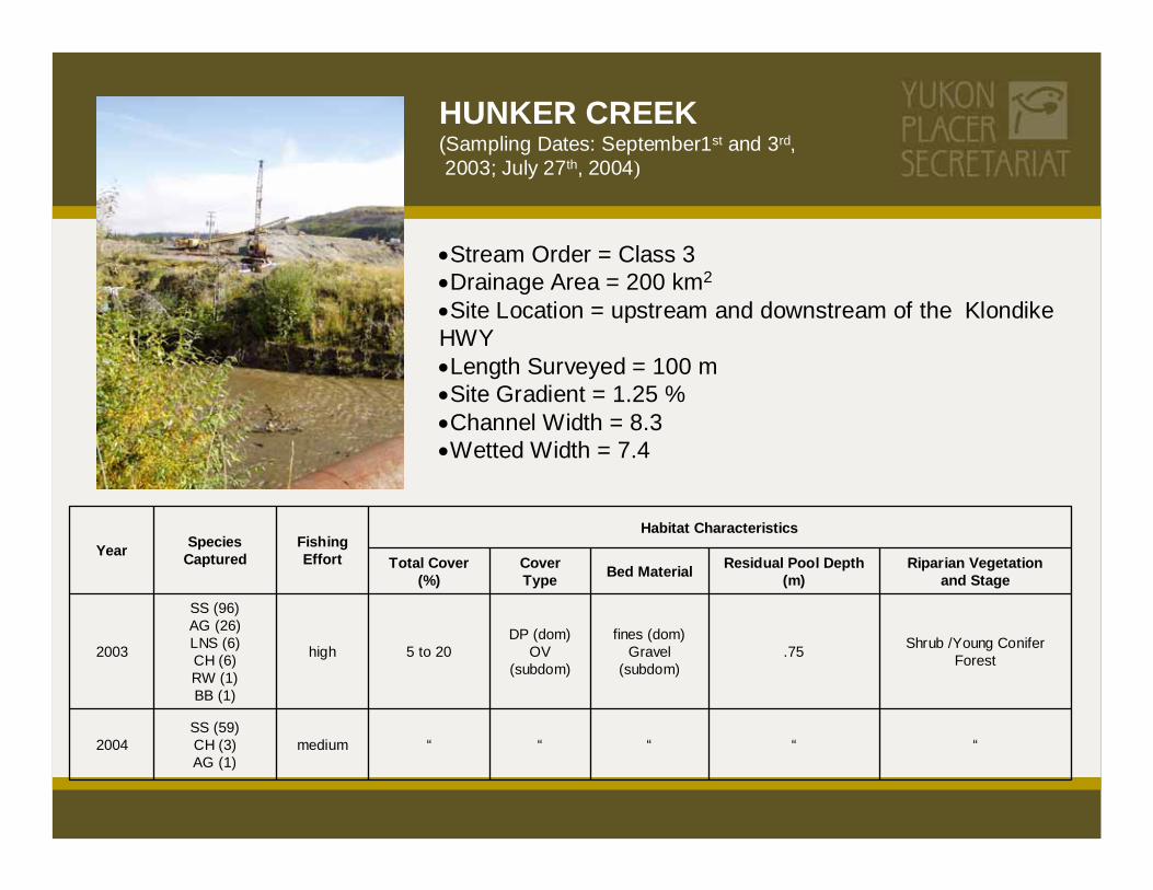
HUNKER CREEK(Sampling Dates: September1st and 3rd,2003; July 27th, 2004)
•Stream Order = Class 3•Drainage Area = 200 km2
•Site Location = upstream and downstream of the Klondike HWY•Length Surveyed = 100 m•Site Gradient = 1.25 %•Channel Width = 8.3•Wetted Width = 7.4
Shrub /Young Conifer Forest .75
fines (dom)Gravel
(subdom)
DP (dom)OV
(subdom)5 to 20high
SS (96)AG (26)LNS (6)CH (6)RW (1)BB (1)
2003
“““““mediumSS (59)CH (3)AG (1)
2004
Riparian Vegetationand Stage
Residual Pool Depth (m)Bed MaterialCover
TypeTotal Cover
(%)
Habitat CharacteristicsFishingEffort
Species CapturedYear

SESTAK CREEK(Sampling Date: July 30th, 2003)
•Stream Order = Class 2•Drainage Area = 55 km2
•Site Location = .4 kilometres upstream of Yukon River•Length Surveyed = 100 m•Site Gradient = 1.4 %•Channel Width = 24 m•Wetted Width = 5 m
Shrub / pole sapling stage.63
Cobble (dom)Gravel and Boulder
(subdom)
OV (dom)B
(subdom)10 to 20medium
AG (44)SS (11)LNS (6)CH (2)
2003
Riparian Vegetationand Stage
Residual Pool Depth (m)Bed MaterialCover
TypeTotal Cover
(%)
Habitat CharacteristicsFishingEffort
Species CapturedYear

INDIAN RIVER (Mainstem)(Sampling Date: August 25th, 2004)
•Stream Order = Class 4•Drainage Area = •2,270 km2•Site Location = 10 km upstream of Yukon River confluenc•Length Surveyed = 200 m•Site Gradient = 0.23 %•Channel Width = 34.2•Wetted Width = 22.2
Mature Mixed Forest
Moderately Turbid
Large Gravel (dom)Small Cobble, Fines
(subdom)
Boulder (dom)Undercut Bank
(subdom)
Moderate5 to 20Low
SS (26)LNS (11)AG (4)LC (3)CH (2)
2004
Riparian Vegetationand Stage
TurbidityBed MaterialCoverType
Total Cover (%)
Habitat CharacteristicsFishingEffort
Species CapturedYear

NINE MILE CREEK(Sampling Date: August 25th, 2004)
•Stream Order = Class 2•Drainage Area = 64 km2
•Site Location = confluence with Indian River •Length Surveyed = 100 m•Site Gradient = 1.1 %•Channel Width = 2.3•Wetted Width = 1.2
Mature Mixed Forest
Slightly Turbid
Small Gravel (dom)
Boulder (subdom)
Boulders, Undercut Bank (dom)
Deep Pool, Overhanging Vegetation (subdom)
Abundant > 20Low
SS (110)AG (24)CH (9)
2004
Riparian Vegetationand Stage
TurbidityBed MaterialCover TypeTotal Cover (%)
Habitat CharacteristicsFishingEffort
Species CapturedYear

OPHIR CREEK(Sampling Date: August 25th, 2004)
•Stream Order = Class 1•Drainage Area = 33 km2
•Site Location = confluence with Indian River •Length Surveyed = 100 m•Site Gradient = 3.75 %•Channel Width = 2.9 m•Wetted Width = 2.2 m
Mature ForestClear water
Boulder (dom)Small Gravel
(subdom)
Boulder and Undercut Bank (dom), Overhanging Vegetation (subdom)
Abundant > 20low
SS (70)CH (3)AG (1)BB (1)NP (1)LNS (1)
2004
Riparian Vegetationand Stage
TurbidityBed MaterialCover TypeTotal Cover (%)
Habitat CharacteristicsFishingEffort
Species CapturedYear

INDIAN RIVER (at Quartz Creek)(Sampling Date: August 25th, 2004)
•Stream Order = Class 4•Drainage Area = 2,270 km2
•Site Location = confluence with Quartz Creek•Length Surveyed = 200 m•Site Gradient = .5 %•Channel Width = 20.7m•Wetted Width =13.6 m
Shrub / initial recolonizationTurbid
Fines (dom)Large Gravel
(subdom)
Small Woody Debris (dom)
Moderate5 to 20low
SS (16)AG (12)NP (6)
LNS (2)
2004
Riparian Vegetationand Stage
TurbidityBed MaterialCover TypeTotal
Cover (%)
Habitat CharacteristicsFishingEffort
Species CapturedYear

0
5
10
15
20
25
4 8 12 16 20 24 28 32 36 40 44 48 52 56 60 64 68 72
Number of Taxa
Perc
enta
ge o
f Site
s
Baseline Sites (n=134)Impacted Sites (n=86)
Impacted Mean21.9 (+/- 2.8)
Baseline Mean33.0 (+/- 2.5)
Data Source: Environment Canada Database
Benthic Invertebrate Richness
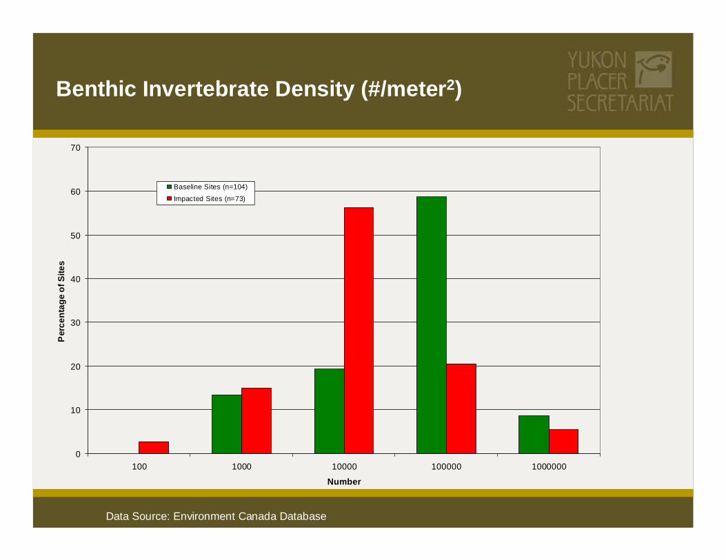
0
10
20
30
40
50
60
70
100 1000 10000 100000 1000000
Number
Per
cent
age
of S
ites
Baseline Sites (n=104)
Impacted Sites (n=73)
Data Source: Environment Canada Database
Benthic Invertebrate Density (#/meter2)

Summary of Field StudiesAll streams had values for both salmon and freshwater fish.
Mined systems had high diversity (number of species groups) of fish and invertebrates, but reduced abundance
Extensive long term mining in large river valleys created habitats favorable to warmwater fish.
Recovery of rearing productivity for juvenile fish relatively rapid after mining.
Physical recovery of habitat for adult fish takes longer.

www.yukonplacersecretariat.ca
206B Lowe Street l P.O. Box 2703 (PS-206) Whitehorse, Yukon Y1A 2C6 l Phone: 867-393-7437 l Fax: 867-667-3632
![Review of the Regulatory Regime for Fund Management ......Review of the Regulatory Regime for Fund Management Companies and Exempt Financial Intermediaries P ... (Rg 10) [“SF(LCB)Regs”].](https://static.documents.pub/doc/80x56/60249ca9726acd1b14244845/review-of-the-regulatory-regime-for-fund-management-review-of-the-regulatory.jpg)


