>>
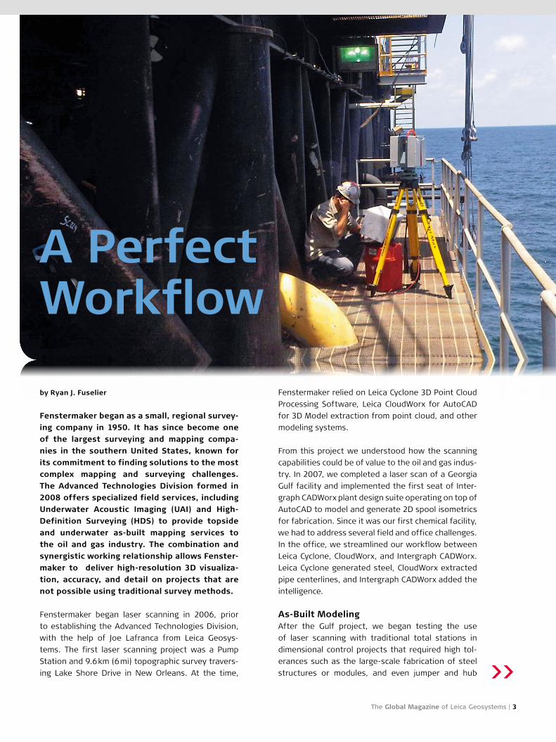
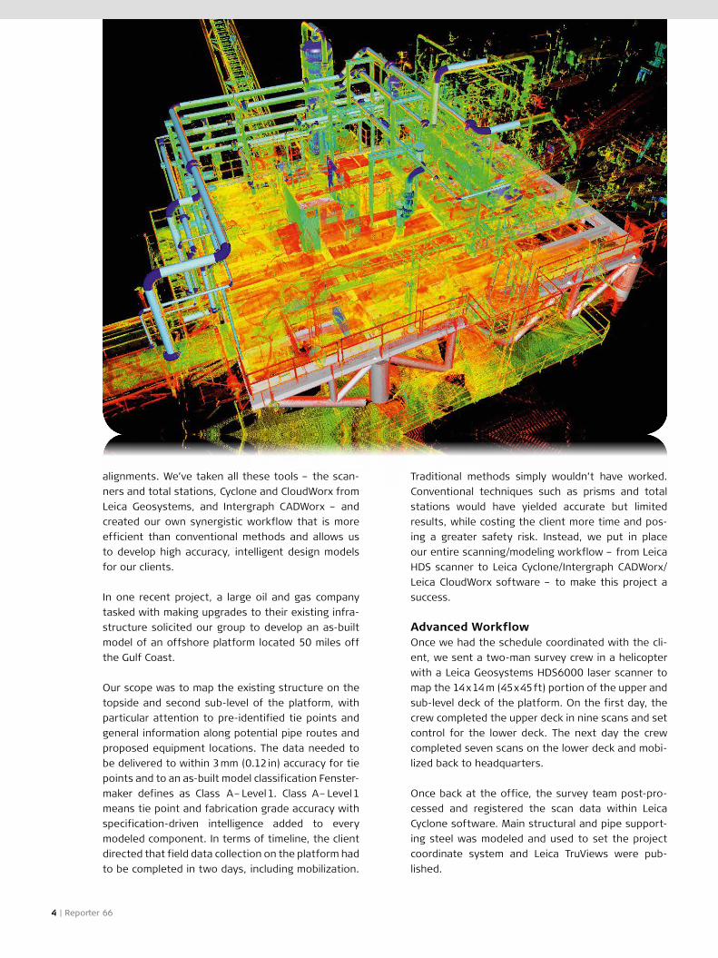
The Global Magazine of Leica Geosystems | 3
by Ryan J. Fuselier
Fenstermaker began as a small, regional survey-
ing company in 1950. It has since become one
of the largest surveying and mapping compa-
nies in the southern United States, known for
its commitment to finding solutions to the most
complex mapping and surveying challenges.
The Advanced Technologies Division formed in
2008 offers specialized field services, including
Underwater Acoustic Imaging (UAI) and High-
Definition Surveying (HDS) to provide topside
and underwater as-built mapping services to
the oil and gas industry. The combination and
synergistic working relationship allows Fenster-
maker to deliver high-resolution 3D visualiza-
tion, accuracy, and detail on projects that are
not possible using traditional survey methods.
Fenstermaker began laser scanning in 2006, prior
to establishing the Advanced Technologies Division,
with the help of Joe Lafranca from Leica Geosys-
tems. The first laser scanning project was a Pump
Station and 9.6 km (6 mi) topographic survey travers-
ing Lake Shore Drive in New Orleans. At the time,
Fenstermaker relied on Leica Cyclone 3D Point Cloud
Processing Software, Leica CloudWorx for AutoCAD
for 3D Model extraction from point cloud, and other
modeling systems.
From this project we understood how the scanning
capabilities could be of value to the oil and gas indus-
try. In 2007, we completed a laser scan of a Georgia
Gulf facility and implemented the first seat of Inter-
graph CADWorx plant design suite operating on top of
AutoCAD to model and generate 2D spool isometrics
for fabrication. Since it was our first chemical facility,
we had to address several field and office challenges.
In the office, we streamlined our workflow between
Leica Cyclone, CloudWorx, and Intergraph CADWorx.
Leica Cyclone generated steel, CloudWorx extracted
pipe centerlines, and Intergraph CADWorx added the
intelligence.
As-Built Modeling After the Gulf project, we began testing the use
of laser scanning with traditional total stations in
dimensional control projects that required high tol-
erances such as the large-scale fabrication of steel
structures or modules, and even jumper and hub
A Perfect Workflow
4 | Reporter 66
alignments. We’ve taken all these tools – the scan-
ners and total stations, Cyclone and CloudWorx from
Leica Geosystems, and Intergraph CADWorx – and
created our own synergistic workflow that is more
efficient than conventional methods and allows us
to develop high accuracy, intelligent design models
for our clients.
In one recent project, a large oil and gas company
tasked with making upgrades to their existing infra-
structure solicited our group to develop an as-built
model of an offshore platform located 50 miles off
the Gulf Coast.
Our scope was to map the existing structure on the
topside and second sub-level of the platform, with
particular attention to pre-identified tie points and
general information along potential pipe routes and
proposed equipment locations. The data needed to
be delivered to within 3 mm (0.12 in) accuracy for tie
points and to an as-built model classification Fenster-
maker defines as Class A – Level 1. Class A – Level 1
means tie point and fabrication grade accuracy with
specification-driven intelligence added to every
modeled component. In terms of timeline, the client
directed that field data collection on the platform had
to be completed in two days, including mobilization.
Traditional methods simply wouldn’t have worked.
Conventional techniques such as prisms and total
stations would have yielded accurate but limited
results, while costing the client more time and pos-
ing a greater safety risk. Instead, we put in place
our entire scanning/modeling workflow – from Leica
HDS scanner to Leica Cyclone/Intergraph CADWorx/
Leica CloudWorx software – to make this project a
success.
Advanced WorkflowOnce we had the schedule coordinated with the cli-
ent, we sent a two-man survey crew in a helicopter
with a Leica Geosystems HDS6000 laser scanner to
map the 14 x 14 m (45 x 45 ft) portion of the upper and
sub-level deck of the platform. On the first day, the
crew completed the upper deck in nine scans and set
control for the lower deck. The next day the crew
completed seven scans on the lower deck and mobi-
lized back to headquarters.
Once back at the office, the survey team post-pro-
cessed and registered the scan data within Leica
Cyclone software. Main structural and pipe support-
ing steel was modeled and used to set the project
coordinate system and Leica TruViews were pub-
lished.
The Global Magazine of Leica Geosystems | 5
Looking AheadFenstermaker plans to continue to capitalize on
their success and work experience to build cutting
edge solutions in the oil and gas service sector. So
many companies and facilities are only scratching
the surface in bridging the gap between data and
management. We are in a unique position having
extensive knowledge of how a synergistic network
exists between the as-built and design world. One
day in the near future our clients will enter a feature
rich Ecosystem with bi-directional communication
between project management, design, construction,
asset management, and training all powered by the
point cloud engine.
About the author:
Ryan J. Fuselier, P.E., P.L.S., is Director of the Advanced
Technologies Division at Fenstermaker.
TruViews allow everyday professionals to easily view
and measure laser point cloud data without exten-
sive knowledge of point cloud software. While navi-
gating a Leica TruView, participants can collaborate
about project needs, generate markups, manage
assets, and acquire 3D coordinate data and measure-
ments.
Modeling Synergy The model was exported using the Cyclone Object
Exchange (COE) format to AutoCAD. Our designers
launched Leica CloudWorx within AutoCAD to model
the piping elements, flanges, and equipment along
with specification-driven intelligence.
Intergraph CADWorx and Leica CloudWorx comple-
ment each other well, both being menu driven pro-
grams within the native AutoCAD environment. The
synergy between these two programs is evident
in terms of functionality and our overall workflow
efficiency. Used together, we can develop an intel-
ligent asset model of existing conditions from which
designers can build the most effective and efficient
retrofit and upgrade for the facility. This ensures
zero to no rework upon installation.
Because the data from the Leica Geosystems
HDS6000 laser scanner was so accurate and com-
prehensive, underlying structural deformation was
uncovered.
During the modeling process, we could see the main
deck structural steel deformation and notify the cli-
ent. We were able to report this vertical deformation
in a color relief map of the entire upper section of
the platform. With this visual and analytical data,
smart decisions could be made by the client concern-
ing corrective measures for reinforcing or replacing
the structural components in the area to handle the
proposed skid load. These unforeseen deformations
could have presented serious installation delays but
were able to be addressed prior to equipment mobi-
lization.
As a final deliverable, the client wanted Fenstermak-
er’s SurvDMS (Data Management System) product
with a specific interest in an intelligent as-built 3D
model. SurvDMS is a portal for serving all project
related deliverables to include TruViews, monument
data sheets, 3D models, and engineering/construc-
tion drawings.
Following the acquisition by Hexagon in 2010, Inter-
graph® is a sister company of Leica Geosystems.
Intergraph operates through two divisions: Security,
Government & Infrastructure (SG&I) and Process,
Power & Marine (PP&M).
Intergraph’s Process, Power & Marine division cre-
ates solutions that enable the design, construction,
and operation of process and power plants, offshore
platforms, and ships, and provides the information
management capabilities to build and operate those
facilities.
The company’s leadership position is backed by a
proven track record of high-quality product develop-
ment, a global customer base of industry leaders,
and a worldwide sales and support network. Inter-
graph Process, Power & Marine’s business is based
on a strong financial foundation and steady growth.
More than two-thirds of the plants built worldwide
are designed using Intergraph software.