Mississippi State University Mississippi State University Scholars Junction Scholars Junction Theses and Dissertations Theses and Dissertations 8-5-2006 A Quantitative Analysis of the Effectiveness of Directed-Discovery A Quantitative Analysis of the Effectiveness of Directed-Discovery Teaching Methods and Weekly Quizzes in a Standardized Teaching Methods and Weekly Quizzes in a Standardized Introductory Earth Science Laboratory Course Introductory Earth Science Laboratory Course Julia Gail Johnston Follow this and additional works at: https://scholarsjunction.msstate.edu/td Recommended Citation Recommended Citation Johnston, Julia Gail, "A Quantitative Analysis of the Effectiveness of Directed-Discovery Teaching Methods and Weekly Quizzes in a Standardized Introductory Earth Science Laboratory Course" (2006). Theses and Dissertations. 238. https://scholarsjunction.msstate.edu/td/238 This Graduate Thesis - Open Access is brought to you for free and open access by the Theses and Dissertations at Scholars Junction. It has been accepted for inclusion in Theses and Dissertations by an authorized administrator of Scholars Junction. For more information, please contact [email protected].
Transcript
Mississippi State University Mississippi State University
Scholars Junction Scholars Junction
Theses and Dissertations Theses and Dissertations
8-5-2006
A Quantitative Analysis of the Effectiveness of Directed-Discovery A Quantitative Analysis of the Effectiveness of Directed-Discovery
Teaching Methods and Weekly Quizzes in a Standardized Teaching Methods and Weekly Quizzes in a Standardized
Follow this and additional works at: https://scholarsjunction.msstate.edu/td
Recommended Citation Recommended Citation Johnston, Julia Gail, "A Quantitative Analysis of the Effectiveness of Directed-Discovery Teaching Methods and Weekly Quizzes in a Standardized Introductory Earth Science Laboratory Course" (2006). Theses and Dissertations. 238. https://scholarsjunction.msstate.edu/td/238
This Graduate Thesis - Open Access is brought to you for free and open access by the Theses and Dissertations at Scholars Junction. It has been accepted for inclusion in Theses and Dissertations by an authorized administrator of Scholars Junction. For more information, please contact [email protected].
A QUANTITATIVE ANALYSIS OF THE EFFECTIVENESS OF DIRECTED-
DISCOVERY TEACHING METHODS AND WEEKLY QUIZZES
IN A STANDARDIZED INTRODUCTORY EARTH SCIENCE
LABORATORY COURSE
By
Julia Gail Johnston
A Thesis Submitted to the Faculty of Mississippi State University
in Partial Fulfillment of the Requirements for the Degree of Master of Science
in Geosciences in the Department of Geosciences
Mississippi State University
August 2006
A QUANTITATIVE ANALYSIS OF THE EFFECTIVENESS OF DIRECTED-
DISCOVERY TEACHING METHODS AND WEEKLY QUIZZES
IN A STANDARDIZED INTRODUCTORY EARTH SCIENCE
LABORATORY COURSE
By
Julia Gail Johnston
Approved:
________________________________ _______________________________ Brenda E. Kirkland Christopher Dewey Assistant Professor of Geology Associate Professor of Geology (Director of Thesis) and Graduate Coordinator (Committee Member) _________________________________ ________________________________ Jamie Dyer F. Leo Lynch Assistant Professor of Meteorology Associate Professor of Geology (Committee Member) (Committee Member) __________________________________ Phil Oldham Dean of the College of Arts and Sciences
Name: Julia Gail Johnston
Date of Degree: August, 2006
Institution: Mississippi State University
Major Field: Geosciences
Major Professor: Dr. Brenda L. Kirkland
Title of Study: A QUANTITATIVE ANALYSIS OF THE EFFECTIVENESS OF DIRECTED-DISCOVERY TEACHING METHODS AND WEEKLY QUIZZES IN A STANDARDIZED INTRODUCTORY EARTH SCIENCE LABORATORY COURSE
Pages in Study: 234 Candidate for Degree of Master of Science
A study was conducted to determine the effects of directed discovery-based
teaching methods and weekly quizzes on learning in an introductory geosciences
laboratory course. Assessment was accomplished using percentages of correct responses
to questions on two tests, using percentages from the first semester of the study as a
baseline to which data from each subsequent semester were compared to determine the
effects of each introduced study variable. Student evaluations of value, meaning, and
enjoyment of the course were investigated through the use of an essay question at the end
of the second test. The study revealed that directed discovery-based methods were
successful for teaching some subject material, but not for all, and that the method did not
necessarily enhance learning of scientific vocabulary. Weekly quizzes resulted in
improved learning in all subject areas. Simultaneous use of traditional and directed-
discovery teaching methods as well as weekly quizzes is recommended.
i
DEDICATION
I would like to dedicate this paper to Dr. Hulon Madely, who is my daily
inspiration. I will always remember to aspire to be the kind of geologist, the kind of
teacher, and the kind of friend that he is.
ii
ACKNOWLEDGEMENTS
The author wishes to express her sincere appreciation to many people
without whose help this study would never have been accomplished. First, my thanks to
my committee chair, Dr. Brenda Kirkland, for her endless patience and understanding
through the whole process of creating this work. Thanks is also due to rest of my
committee members, Dr. Chris Dewey, Dr. Jamie Dyer, and Dr. Leo Lynch for working
within the compressed time frame for pulling this paper together, and for their help with
the frustrations of the research and the writing process. Thanks to my fellow graduate
students, who cooperated, mostly without complaint, with the constant changing of their
teaching methods and for supplying me with the classroom time and the data necessary
for the study. Thanks to all of the Earth Science I lab students who agreed to be my
subjects for the study and allow me to use their grades and their images for this paper.
Lastly, I’d like to thank my family, and especially my husband, Rick, who have allowed
me the freedom from responsibilities at home to dedicate the time I needed to this degree.
iii
TABLE OF CONTENTS
Page
DEDICATION.............................................................................................................. i
ACKNOWLEDGEMENTS.......................................................................................... ii
LIST OF TABLES........................................................................................................ iv
LIST OF FIGURES ...................................................................................................... v
CHAPTER I. INTRODUCTION................................................................................................. 1
II. METHODS............................................................................................................ 7
IRB Permission Slips ........................................................................................ 7 Selection of Target Questions........................................................................... 9
III. TEACHING METHODS...................................................................................... 12
Incremental Changes in Each Semester............................................................ 12 Baseline: Spring 2005: Hand-in Labs and Two Tests ...................................... 13
Standardization ............................................................................................. 15 Introduction of the Mississippi Lab .............................................................. 16
Summer 2005: Introduction of Pre-Lab Exercises ........................................... 16 Fall 2005: Directed Discovery-Based Instruction ............................................ 18 Spring 2006: Weekly Quizzes .......................................................................... 19 Follow-up Study ............................................................................................... 20 Evaluations by Teaching Assistants and Professors ......................................... 21
IV. STATISTICAL METHODS................................................................................ 22
Collection of Test Answer Sheets..................................................................... 22 Spreadsheet ....................................................................................................... 22 Correlation of Questions................................................................................... 23 Learning-Level Analysis................................................................................... 24 Statistical Analysis............................................................................................ 24 Graphing Techniques........................................................................................ 25
iii
CHAPTER Page
V. RESULTS ............................................................................................................ 31
Correct Responses to All Questions ................................................................. 31 Correct Responses to Target Questions ............................................................ 32 Comparison of Statistically Significant Questions ........................................... 34 Most and Least Favorite Labs........................................................................... 43
VI. DISCUSSION...................................................................................................... 50
Standardization ................................................................................................. 50 Mineral and Rock Tests .................................................................................... 50
Most and Least Favorite Labs........................................................................... 59 Inherent Limitations of the Study ..................................................................... 63
Human Subjects ............................................................................................ 63 Hurricane Katrina.......................................................................................... 64
APPENDIX A IRB Forms........................................................................................................ 74
B Tests ................................................................................................................. 85
C Labs .................................................................................................................. 167
D Follow-Up Study.............................................................................................. 226
E Spreadsheet....................................................................................................... 233
iv
LIST OF TABLES TABLE Page 1 Target Questions for the Study .............................................................................. 10 2 Statistically Significant Questions from the Mineral and Rock Tests ................... 34 3 Statistically Significant Questions from the Final Exams ..................................... 35
v
LIST OF FIGURES
FIGURE Page 1 Level 1 (Memorization) Questions from Mineral and Rock Tests ........................ 27 2 Level 2 (Recognition) Questions from Mineral and Rock Tests ........................... 27 3 Level 3 (Interpretation) Questions from Mineral and Rock Tests......................... 28 4 Level 1 (Memorization) Questions from Final Exams – Questions 1-50.............. 28 5 Level 1 (Memorization) Questions from Final Exams – Questions 51-100.......... 29 6 Level 2 (Recognition) Questions from Final Exams ............................................. 29 7 Level 3 (Interpretation) Questions from Final Exams ........................................... 30 8 Target Question Percentages for All Semesters and Follow-up Study.................. 33 9 Deviations from Baseline from Mineral and Rock Tests – Fall 2005 –
Addition of Directed Discovery-Based Exercises ........................................... 38 10 Deviations from Baseline from Final Exams – Fall 2005 –
Addition of Directed Discovery-Based Exercises ........................................... 38 11 Deviations from Baseline from Mineral and Rock Tests – Spring 2006 –
Addition of Weekly Quizzes............................................................................ 39 12 Deviations from Baseline of Level 1 (Memorization) Questions from Final Exams – Spring 2006 – Addition of Weekly Quizzes ..................................... 40 13 Deviations from Baseline of Level 2 (Recognition) and Level 3 (Interpretation)
Questions from Final Exams – Spring 2006 – Addition of Weekly Quizzes .. 41 14 Cumulative Effects of All Variables from the Mineral and Rock Tests................ 41
15 Cumulative Effects of All Variables on Level 1 (Memorization) Questions From the Final Exams....................................................................................... 42
vi
FIGURE Page 16 Cumulative Effects of All Variables on Level 2 (Recognition) and Level 3
(Interpretation) Questions from the Final Exams ............................................ 42
17 Favorite Labs in Spring 2005................................................................................. 44 18 Favorite Labs in Fall 2005 ..................................................................................... 44 19 Favorite Labs in Spring 2006................................................................................. 45 20 Least Favorite Labs in Spring 2005 ....................................................................... 45 21 Least Favorite Labs in Fall 2005 ........................................................................... 46 22 Least Favorite Labs in Spring 2006 ....................................................................... 46 23 Diagram for Environments of Formation of Igneous Rocks ................................. 52 24 Diagram of Depositional Environments for Sedimentary Rocks .......................... 53 25 The “Slime” Glacier is demonstrated in front of the lab ....................................... 56 26 Students use Model Magic® to simulate the results of various stresses
on ductile rocks ................................................................................................ 57 27 The “rocks” elongate and thin in response to application of continued stress....... 58 28 Students discover the direction of movement along a reverse fault as a result
of compressional stress .................................................................................... 58 29 Students pour colored water into a contour box as the first step in creating
a topographic map on the lid of the box. ......................................................... 59 30 After each consecutive centimeter of water is added, students draw the contact between the water and the volcano onto the lid with an erasable marker........ 60 31 When the volcano is submerged, the final topographic map is complete.............. 60
vii
FIGURE Page 32 Students adjust the hose until the water level remains constant to simulate
stream flow in the flume .................................................................................. 61 33 As the colored, salty, ice water is added upstream, the pollution flows along
the bottom of the flume.................................................................................... 61 34 Students must actively participate to see the high-density water that simulates
a pollution front in the lower part of the flume................................................ 62 35 The Mississippi Coast before Hurricane Katrina (July 8, 2000) ........................... 65 36 The Mississippi Coast after Hurricane Katrina (October 18, 2005) ...................... 65
1
CHAPTER I
INTRODUCTION
The objective of this study was to conduct a quantitative analysis to determine the
most effective teaching methods for an introductory college-level laboratory course in
geosciences. Different methods of teaching the course to a group of students that
consisted mainly of non-science majors were compared. The research hypothesis was
that the use of directed discovery-based teaching methods would be more effective than
PowerPoint-driven lectures given by teaching assistants followed by completion of lab
manual or pre-lab exercises for teaching basic introductory earth sciences concepts. It
was expected that the directed discovery-based method would result in more effective
learning of the course material. In addition, the effect of weekly quizzes on learning was
investigated.
The methodology used in this study was to quantitatively assess test material in an
introductory earth sciences lab course. The development of the methodology, choices of
subject matter for the labs, production of PowerPoint-based lectures, creation of directed
discovery-based experiments, writing of pre-lab exercises, lab exercises, quizzes and
tests, and interpretation of the data required that the researcher have a graduate-level
understanding of geologic concepts and processes. In addition, it was necessary for the
2
researcher to have experience in the classroom and leadership abilities to obtain the
cooperation of the laboratory teaching assistants who act as instructors in the course.
Research into the demographic distribution of the students in geosciences courses
has been the focus of a minority enrichment program (Kirkland, 2006; Milliken and
Kirkland, 2006). A profile of the student enrollment in this lab indicates that the sample
set is representative of the university as a whole in gender, ethnicity, class standing,
overall grade point average, and major field of study, with the sole exception that
engineering majors are underrepresented. The sample size of 200-300 students who take
the Earth Science I Lab each semester represents 1.5-2% of the entire undergraduate
student body at Mississippi State. The size of this data set is sufficiently large that it
could be assumed to be statistically representative of the student body as a whole (Burt
and Barber, 1996).
The most effective methods for teaching science have been a matter of
considerable debate among American educators for many years (For reviews of literature,
see McDonald, et. al., 2005; Libarkin and Anderson, 2005). While most teachers would
agree that a basic education in science is essential to a well-rounded education, exactly
what that basic education should entail and how it should be taught has been the subject
of articles in education journals throughout the last 100+ years.
Traditional education in science usually consists of teacher-directed learning in
which the material covered, as well as the methods by which that material will be
presented and the students’ learning assessed, are determined by the educator. For the
past 60 years or so, federally-funded programs have driven the prevailing methods in
3
America’s science classrooms to include laboratory experiments designed to enhance the
students’ understanding of science through hands-on experience (Carin and Bass, 2001).
Most modern high schools are equipped with laboratories in order to facilitate these
experiments, which have been considered vital to the scientific educational experience
(Hofsteina and Lunetta, 2004).
In the 1960’s, an innovation in the education of science was introduced with the
concept of discovery-based learning (Kuslan, 1968; Wittrock, 1966). The basic concept
is for the learning to be student-directed rather than teacher-directed, with the students
drawing on their past experiences and natural curiosity to drive them to ask questions
leading to the scientific investigation of new problems. In the modern American
classroom with 25 or more students and only one teacher, it is usually impractical to
allow students to follow their own curiosity on subject matter. In addition, the main ideas
of discovery-based learning are that the process of developing the method of study and
experimenting to find the questions as well as the answers is as important to the students’
education as the mastery of the subject matter. A basic tenet of the process is that by
allowing the students to fail they will be led to further questions and eventual arrival at
creative answers. The goal, therefore, is the experience of the process, and not
necessarily the eventual learning of the accepted answers (Hendrix, 1961). All of these
concepts, while theoretically appealing, prove to be impractical in the modern classroom
setting, nor do they allow a student to develop a deep content base. While development of
problem-solving and group dynamic skills may be important goals for primary and
secondary students, they may still be left unprepared for the right-or-wrong approach of
4
standardized college entrance exams and most college curricula. Scientific study at the
collegiate level focuses more upon the mastery of information than the exploration of
scientific methodologies and use of the failure-to-success paradigm. One of the
important outcomes of this study was to determine whether discovery-based methods can
be utilized effectively to promote mastery of course material. The design of the
discovery-based exercises themselves must be more focused on the goal of what
Chiappetta and Adams (2004) call “content”, rather than emphasizing “process” or some
combination of the two.
So much discussion has filled the professional journals over the past 40 years or
so about the benefits and drawbacks of discovery-based learning, that an exhaustive
literature review of the entire question is impractical. It appears that the mainstream of
the educational community advocates the use of the system in theory, while recognizing
the impracticality of its implementation on a large scale (Button, 1971; Carin and Bass,
McConnell, et. al., 2003). As part of the acceptance of the idea, however, comes the
prevailing belief that hands-on laboratory experiences enhance the students’
understanding of the subject matter taught by the less-involved methods of reading,
listening to lectures, and note-taking. Some educators who advocate the more give-and-
take approach of Socratic debate-based lecturing recognize directed discovery-based
laboratory exercises as the next logical step (Paul, 1995; SERC, 2006; UNC-CH, 2001).
While many studies have been completed for the use of discovery-based
methodologies at elementary and secondary levels (Castronova, 2002; Chiapetta and
5
Adams, 2004; Hofstein and Lunetta, 2004; NRC 2005), very few studies investigate this
issue at the college level (Harris, 2002). Almost exclusively, the published studies deal
with the way children learn, as opposed to the learning methods that will be effective for
college students, who experience a transition through levels of cognitive development
during the course of their studies. While many publications have contributed novel ideas
for active participation in geosciences labs (Baker, et. al., 2004; Calderone, et. al., 2003;
Guertin, 2005; Harpp, et. al., 2005; Mylroie, 1978), only one study was found that
investigated what is being done by teachers in the college classroom (MacDonald, et. al.,
2005). No studies were found that made a quantitative assessment of the effectiveness of
hands-on experiments in a college introductory geology lab course.
The elimination of a requirement for Earth Science from many grade school and
high school curricula has left a void in the education of American children. It is hoped
that the interest generated through this hands-on learning experience in students who
have not yet declared a major might provide a pool of otherwise-undiscovered geologists.
While the study was conducted using students at Mississippi State University, the course
and methods will have broad-based applications to many other, similar courses taught
elsewhere. Only the final lab, which relates all of the concepts studied throughout the
semester to the geology of Mississippi, would have to be revised for use in other
institutions.
The results of this study should give insight into possible improvements in the
way introductory science courses are taught in colleges. The information gained from
this study will benefit educators in understanding the adult learning process and the
6
teaching methods that might best be employed to enhance learning of scientific course
materials.
7
CHAPTER II
METHODS
IRB Permission Slips Given that this study involved the use of human subjects, it was necessary to
obtain approval by the Institutional Review Board (IRB) before the project could begin.
IRB approval was granted on Nov. 10, 2004 (Appendix A). To comply with IRB
standards, human subjects must be informed that their participation is entirely voluntary,
and any information obtained or their permission or refusal to participate will have no
effect on them or their grade in the course. A standard permission slip form was
constructed and approved through the IRB office on campus as part of the application for
IRB approval (Appendix A).
At the beginning of each semester, the researcher visited each section of the lab.
The researcher introduced herself, explained the purpose and overall methodology of the
study, and asked each student to give permission to participate in the study. It was
reiterated that participation or refusal would not affect them or their grades in any way,
and that participation was entirely voluntary. It was explained that answers from the
Mineral and Rock Test and the Final Exam would be used as the data set for a study with
the purpose of evaluating the teaching methods used in the lab course and how changes in
8
the teaching methods will affect learning of the course material. The students were
assured that neither their names nor identifying numbers would be attached to their
individual grades or performance on the tests or on the follow-up study, and that the data
would be analyzed simply as percentages. It was explained that this is part of a Master’s
thesis, and as such would be presented to the faculty and students of the department,
retained in the MSU library, and possibly published in a professional journal and/or
presented at professional conferences. Subjects were then asked to sign the front of the
permission form if they gave permission for use of their test answers and grades for the
study.
Next, the students were told that a follow-up study would be conducted three to
four months after they take the Final Exam. It was explained that by providing their
contact information, they were not promising to participate in the follow-up study, merely
giving permission for the researcher to contact them and ask them to participate. It was
explained that there would be a reward for participation in the follow-up study in the
form of $6.00 in gift certificates to Wendy’s (which could be used in town or at the
Student Union). Funding for the incentives would be from personal funds provided by
the researcher. Subjects were then asked to complete the contact information and sign the
back of the permission form if they gave permission to contact them for the follow-up
study.
Finally, the students were asked to sign image waivers if they gave permission for
photos taken by the researcher in lab to be used for the thesis, the thesis presentation,
publication, or for presentation at professional meetings.
9
In total for the four semesters, 548 of 870, or 63% of students enrolled in the
course, gave permission for the use of their grades and contact information for the
follow-up study. The permission slips were locked in a secure location to protect the
privacy of the students.
Selection of Target Questions A review of all of the subject material for the course was conducted to identify a
set of 25 target questions for this study. The questions were chosen to function as an
overview of the course material, emphasize key concepts that are essential to
understanding the Earth and its processes, and represent a basic knowledge base that the
students might apply to the situations they encounter in their daily lives by simple
observation of the world around them. Concepts from each lab were included in the
target set, with particular attention paid to knowledge that might have further practical
application outside the university. The list of target questions was edited by the professor
who oversees the lab and all of the graduate students who teach the lab. The final list of
target questions included 24 subject questions and one final essay question asking which
was the student’s favorite lab and why. The target question set included seven questions
from the Mineral and Rock test and 18 questions from the Final Exam (Table 1).
10
Table 1: Target Questions for the Study Q # Question Answer
1 The only difference between a conglomerate and a breccia is that conglomerates have rounded gravel-sized sediments and breccias have angular gravel-sized sediments. What does the shape of the sediments reveal about these two sedimentary rocks?
The sediments in the conglomerate traveled much farther than the sediments in the breccia.
2 Where does the sediment that forms sandstone come from?
Mechanical/chemical weathering of pre-existing rock.
3 In Metamorphic rocks, what does the parent rock refer to?
The original rock before it underwent a metamorphic change.
4 What type of rock can be changed by a metamorphic event? Igneous, sedimentary, and metamorphic rock
5 Forms from weathered (chemical or mechanical) fragments of rock, consisting of remains or secretions of plants/animals, or precipitation
Sedimentary rock
6 Forms from molten rock (magma or lava). Igneous rock
7 An inorganic, naturally occurring substance that has a characteristic chemical composition, distinctive physical properties, and crystalline structure.
Mineral
8 Forms by changing from one form to another by intense heat, intense pressure, or the action of watery hot fluids.
Metamorphic rock
9 Which stress creates folds such as anticlines and synclines? Compressional stress
10 Which stress causes reverse or thrust faults to occur? Compressional stress
11 Which stress causes left or right lateral faults? Shear stress
12 Which stress causes normal faults? Tensional stress
13 You have just won the lottery and your friends tell you, “California is the place you ought to be” so you load up the truck and move to Beverly (as in Los Angeles). You must decided on which property to build your mansion. Which land would you choose to make your home as safe as possible from the devastating effects of an earthquake?
Granite rock
14 From the scenario in question #13, which of these choices would be the worst location to build on?
An old landfill now covered with dirt and grass
15 What is another name for 0° latitude?
Equator
16 The North and South poles are Maximum latitude
17 What direction does the stream flow in Diagram L (labeled Question 64)?
Northwest to southeast
11
Table 1 (Continued)
18 What feature is Berlson Lake (labeled Z) on Diagram O (labeled Question 67)?
Oxbow lake
19 What type of valley is characteristic of a straight stream channel?
V-shaped
20 What is the biggest problem associated with building jetties and groins?
They disturb the natural sediment transport and cause erosion
21 Exposed marine terraces, wide beaches, and salt marshes are features of what type of coastline?
Emergent coast
22 A submergent coastline can be caused by:
Sea level rising or the land sinking (subsiding)
23 What natural coastline feature can be used to determine the direction of the longshore current?
Spit
24 Where in the world today are ice sheets still present? Antarctica and Greenland
25 Which was your favorite lab? Why?
12
CHAPTER III
TEACHING METHODS Incremental Changes in Each Semester The Earth Science I Lab (GG1111) is a stand-alone course and not part of the
Introduction to Earth Science course (GG1113). There is a degree of autonomy, allowing
the graduate teaching assistants (TAs) to develop the course and change the teaching
methods for the benefit of the students. While many students take the lecture and lab
courses concurrently, many have taken the lecture in previous semesters, and some have
not had the lecture course at all. In a discussion with members of the faculty, the “ideal
lab” was defined as a setting in which the students would be interested in the subject
matter, motivated to learn and ask questions, and feel that the lab enhanced their
understanding and learning of the subject matter for the lecture section if they were
currently enrolled in GG1113. Students should consider the science learned in the lab to
be valuable to their daily lives to enhance their motivation to learn (Dewey, 2005).
Finally, we would like the students and TAs to enjoy the learning process.
The lab as it was being taught was a long way from our concept of the ideal.
Comments from and attitudes of students in the classroom indicated that they were not
recognizing the value, meaning, and benefits of their time spent in the lab, nor were they
13
having much fun. Instead, the majority of students expressed the opinion that the subject
matter was boring and useless, the lab was too difficult, the lab was not helping them to
do better in the lecture section, they saw no relevance to the information in their lives
outside the lab, and it was their least favorite class. Those students who enjoyed the lab
attributed this to the TA, who was trying her/his best to make the lab an enjoyable
learning experience.
A plan of action was constructed using the “ideal lab” as a model. Incremental
changes would be made at the rate of one per semester as the test variables for this study.
Each semester’s variable was implemented with the intention of moving the lab closer to
the ideal, while allowing tracking of the effects of the variable on learning of the lab
material. Additionally, anecdotal information was sought from the TAs that indicated the
effects of the changes on the perception of the value, meaning, and benefits of the course,
as well as the enjoyment of the lab by the students and the TAs.
Baseline: Spring 2005: Hand-in Labs and Two Tests
The format for the baseline semester was “hand-in labs and two tests”. Each week
covered a different subject, and students worked in pairs, but each turned in an individual
lab assignment before leaving the lab. There were eleven lab exercises during the
semester. At the end of the semester, the lowest lab grade was dropped for each student.
In-class lab assignments counted as 25% of the final grade for the course.
The first test was the Mineral and Rock Exam (Appendix B), given during the
fifth lab meeting of the semester. Each student received an individual box of minerals and
rocks in front of him/her along with the test and an answer sheet. The questions on the
14
test were designed so that there were at least three questions that tested understanding of
the concepts emphasized in the lab leading to each rock or mineral identification (ex.
What is the streak of mineral J?). Each sample was identified in the question as being a
mineral, an igneous rock, a sedimentary rock, or a metamorphic rock, because the goal
was for students to understand the classification procedures for each type of rock and
how to apply them, rather than simply how to tell a sedimentary rock from an igneous
one. Most geologic concepts are understandable without specialized vocabulary and,
because it was the goal of the course for the students to learn and retain concepts, the use
of technical terminology was minimized in the questions. Understanding of the processes
that create rocks, such as the types of volcanoes and magmas or depositional
environments of sediments, was also tested. All questions were multiple-choice format to
emphasize recognition of the correct information and eliminate ambiguity in grading, as
well as spelling and grammar issues. There were two versions of the test (A and B) so
that each pair of students who were lab partners and shared a table had a different version
and different rocks and minerals, to prevent cheating. If questions were duplicated on the
two versions, they were numbered differently. The Mineral and Rock Test consisted of
50 multiple-choice questions and counted as 25% of the final grade for the course.
The second test was the Final Exam (Appendix B) given at the end of the
semester. Again, technical terminology was kept to a minimum and concept questions
outnumbered memorization questions. Emphasis on understanding of concepts over
memorization required the use during testing of the geologic tools to which the students
were introduced during the lab meetings. Sets of full-sized topographic maps were
15
provided to each pair of students. Each student also received an individual folder that
contained his/her test, answer sheet, diagrams, color photographs, and small maps that
related to the test, as well as a ruler and a simple calculator. All questions were multiple-
choice format, for the same reasons as on the first test. Again, there were two versions of
the test (A and B) to prevent cheating. The two people who sat at the same lab table did
not have the same version of the test or diagrams. If questions were duplicated on the
two versions, they were numbered differently. Space restrictions necessitated sharing of
the maps during the test, but the benefits to the students of utilizing the tools with which
they were familiar and were expected to understand greatly outweighed the
inconvenience. Mastery of all of the geologic tools and processes included in the labs
following the first test was evaluated by 100 questions. In this baseline semester, the
Final Exam score counted as 50% of the total grade for the course.
Standardization To ensure that the target questions (and any other material contained on the two
tests) were covered adequately in all sections, it was necessary to standardize the lectures
given by the teaching assistant in each section, the lab exercises, and the tests. The
researcher had the responsibility in her position as Lab Coordinator to construct the
PowerPoint presentation (Appendix C) that was used each week for an opening lecture by
each TA and for clarification during lab exercises. The Microsoft® PowerPoint
presentation program allows projection of photographs and diagrams to be paired with or
interspersed with text for use by the lecturer. Other responsibilities of the Lab
Coordinator included choice of the lab exercises (Appendix C), procurement of the
16
proper materials, and provision of a key that each TA used to correct the labs. The
responsibilities provided some degree of experimental control. A mandatory TA meeting
was conducted every Friday afternoon, at which the current week’s lab was reviewed for
problems and the following week’s PowerPoint and lab exercises were demonstrated.
The researcher led the meetings, fielded questions and concerns, and facilitated resolution
of any conflicts that arose.
Introduction of the Mississippi Lab The last regular lab period before the Final Exam has traditionally been used to
review the material the students need to study for the Final Exam. For this semester, the
last lab period was redesigned as a discovery-based exercise (Appendix C). The exercise
served the threefold function of giving the students new information about their home
state, showing them how the information they learned in the course could be relevant to
their day-to-day lives, and helping them to discover what part of the course material they
needed to review in more depth before the Final Exam. The students left this lab period
with a Final Exam Study Guide (Appendix C).
Summer 2005: Introduction of Pre-Lab Exercises For this first experimental semester, the standard PowerPoint presentations and
lectures, the “Hand-In Labs and Two Tests” format, and the identical Mineral and Rock
Tests and Final Exams from the spring semester were retained.
Pre-lab exercises (Appendix C) were introduced for this term, and the effects that
this first variable had on student learning and retention were tracked as part of the data
17
for the thesis. Pre-lab exercises were given to the students at the end of the lab period
each session to be completed as homework and returned at the beginning of the following
week’s lab session. Pre-lab exercises consisted mainly of vocabulary, definitions, and
delineation of the observations that would be required of the students during the
following lab. The answers were obtained from the student’s lab manual, mostly
covering defined key words. The pre-lab exercises should have been completed by the
students in 20 minutes or less each week. One hypothesis of this study was that a cursory
introduction to the vocabulary and other material before arriving in the lab would
improve understanding, learning, and retention.
Grading for the course required adjustment. It was decided the Final Exam had
been too heavily weighted in previous semesters, and that more emphasis should be
placed on completion of the hand-in lab exercises. The two tests together constituted
one-half of the points for the course, and each was weighted proportionally to the number
of lab meetings and the amount of information it tested. Completion of the pre-lab
exercise was weekly and its purpose was to enhance understanding of the subsequent lab
exercise. Pre-labs and lab exercises together comprised the remaining half of the points
for the course. It was necessary to choose a point value for the pre-labs that was heavy
enough to ensure that most students would take the time to complete the exercise, while
at the same time recognizing that participation in, and completion of, lab exercises
required more time and effort than pre-labs. The percentages then became 10% Pre-lab
exercises, 40 % Lab exercises, 20 % Mineral and Rock Test, 30% Final Exam.
18
Fall 2005: Directed Discovery-Based Instruction
In this semester, the directed discovery-based learning was implemented in all lab
sessions. Pre-lab exercises, the “Hand-In Labs and Two Tests” format, and the grading
scale from the summer semester were retained. Adjustments to both tests (Appendix B)
were necessary to reflect the changes in the instruction methods, but care was taken to
retain the target questions for this study without alteration.
Directed discovery-based lab activities (Appendix C) were introduced into the
lesson plan of each lab session. The activities were self-directed by the students whenever
possible, with the understanding that some instruction by the TAs might be necessary,
depending upon the subject material being covered. Most lab exercises consisted of a
series of leading questions that directed the student toward discovery of understanding of
the subject material. When possible, PowerPoint lectures were eliminated altogether. If
necessary, standardized lecture materials in PowerPoint were used, but broken into
shorter segments, with students completing activities between segments as was
appropriate.
A small number of extra-credit exercises (Appendix C) was added to the
curriculum. The exercises were completely self-directed, as they were completed by the
students outside of the lab and returned to the TA at the following lab meeting. The
subject matter of the exercises was related to but not directly addressed in the lab
meetings. The points for the extra-credit exercises were added to the lab exercise grade,
allowing for some recovery in case of a low lab exercise grade.
19
Spring 2006: Weekly Quizzes
For this semester, pre-lab exercises, directed discovery-based lab exercises, extra
credit assignments, and PowerPoint presentations from the previous semester were
continued. Adjustments to both tests were necessary to reflect the changes in the
instruction methods (Appendix B), but care was taken to retain the target questions for
this study without alteration.
A change in the format from the “Hand-In Labs and Two Tests” format to
“Weekly Quizzes and Two Tests” format was made. The students completed the same
lab exercises as in the fall semester, which were checked for accuracy before the student
left the lab, to ensure that the students had the correct answers from which to study for
the following week’s quiz. The first task in lab each week was a multiple-choice quiz
(Appendix C) on the previous week’s lab material. Quizzes were substituted in the
grading scale for the hand-in lab exercises from previous semesters, and no lab exercises
were turned in by the students. Each TA wrote his/her own quizzes, emphasizing the
material in the manner that he/she taught it the previous week. All TAs were asked to
include the target questions from this thesis on their weekly quizzes. The emphasis for
the quizzes was intended to be on understanding of the concepts rather than
memorization. Questions were derived from either lab exercises or pre-lab exercises.
Quizzes replaced the lab exercises in the grading scale and constituted 40% of the total
grade for the course.
20
Follow-up Study Approximately four months after the completion of the spring, 2005 and fall,
2005 semesters, the students who gave prior permission were contacted by e-mail or
telephone and asked to participate in the follow-up study (Appendix D). The follow-up
study was held each time in the lab early on a weekday evening. The students were
reminded that they had given permission for the contact, that the study would require
about half and hour of their time, and they would be compensated with $6.00 in Wendy’s
gift certificates for their participation.
The study consisted of the target questions for this thesis (Appendix D). The
students were given no prior notice that the study would be a “quiz”, so it was assumed
that they had no contact with the course materials for the previous four months since
completing the Final Exam for the course. It was implicit that long-term retention of the
target question materials was being tested by the follow-up study.
According to standard marketing response patterns, it was expected that 5-10% of
students would participate. Unfortunately, the expectation was not realized, and a total of
only 26 students participated in the study for the two semesters it was conducted. It is
suspected that the incentive was not large enough to elicit the amount of effort required
by the students to come to the follow-up study. The small number of participants
necessitated elimination of the follow-up study from the thesis results because the
numbers were not adequate for appropriate statistical analysis.
21
Evaluations by Teaching Assistants and Professors At the end of each semester, the Teaching Assistants were asked to provide a
short written evaluation of the semester. Feedback about lab materials, teaching
methods, and general attitude of the TAs and the students was the goal of the evaluations.
The same feedback was requested from the professors who hold oversight authority for
the lab and the study.
22
CHAPTER IV
STATISTICAL METHODS
Collection of Test Answer Sheets After the students completed the Mineral and Rock Tests and the Final Exams
each semester, the answer sheets (Appendix B) were collected from the TA for each
section. Each answer sheet was then stapled to the corresponding permission slip
obtained from the student at the beginning of the semester, filed according to section
number, and sorted alphabetically within each section. Answer sheets from the students
who did not give permission for their inclusion in the study were filed separately and not
used.
Spreadsheet Each student’s responses from the Mineral and Rock Test answer sheet were
entered into a spreadsheet by using a 1 if the student answered the question correctly and
a 0 if the student answered incorrectly (Appendix E). The total at the end of the row was
then calculated and doubled (because there were 50 questions on the test) to obtain a
percentage score for the student’s test, which was double-checked against the TA’s grade
on the sheet, to ensure accuracy. Columns were added to obtain the number of correct
responses to each question, which was used to calculate percentages for analysis.
23
The same method of data entry was used for the Final Exams, with an entry of 1 if
the student correctly answered the questions and a 0 if s/he did not. Questions 98 and 99
on the Final Exam asked the student which was his/her favorite lab and why and which
was his/her least favorite lab and why. The answers to questions 98 and 99 were short
answer or essay in nature, so codes of several letters were entered into these two columns
to indicate each student’s answers.
After an alphabetical worksheet was generated for each semester, subsequent
worksheets were obtained by a simple copy-and-paste procedure to separate the Mineral
and Rock Test data from the Final Exam data, to separate the A and B versions of the
tests, and to create worksheets that line up corresponding questions and eliminate names
or any other identifying data from the data set. Only data from the final set of worksheets
were used for summary, analysis, and graphing.
Correlation of Questions Each test was generated as two versions, A and B, to reduce the possibility of
cheating during testing. Most of the questions were identical, but numbered differently
on the two versions. Sometimes, the questions were testing the same concept, but made
use of different diagrams or photographs. Entire questions were sometimes eliminated
from one semester and new ones inserted to reflect the changes made in the teaching
methods and content material in the lab.
The same question had different numbers on the different versions and during
different semesters, so each question was assigned a reference number which was used to
24
correlate student response. Care was taken to include the target questions every semester,
and questions not used in all four semesters were eliminated from the data set.
Learning-Level Analysis
A system was developed by the researcher to distinguish the questions according
to the skills required to answer them to determine whether the teaching method might
have more impact on the learning of a particular type of question. Each question was
assigned a learning-level value. The levels were defined as follows:
Level 1 – questions that require memorization of facts
Level 2 – questions that require students to use the tools learned in lab to
recognize properties of minerals and rocks or derive information from maps or
diagrams
Level 3 – questions that require students to interpret Level 1 or Level 2
information to draw conclusions, or that require mathematical calculations
The number of correct responses at each of these levels was evaluated to determine
whether the study variables had more effect on learning and/or retention of the material
for particular levels of questions.
Statistical Analysis Summation of the columns on the correlated pages produced the total number of
students who responded correctly to each reference question. The sum was then divided
by the total number of students in the study for each semester to obtain a percentage of
correct responses. The number of possible answer choices for each question was
25
determined (it varied from 2 to 5) and a percentage of correct responses that would occur
randomly was calculated for comparison to the actual percentage of correct responses.
Comparison of data from all semesters was conducted by calculating the deviation
of the percentage of correct responses on each question to the percentage of correct
responses in the baseline semester. Analysis to determine the statistical significance of
each question was conducted using a two-tailed, paired sample t-test, comparing Spring
2005 to Fall 2005, Fall 2005 to Spring 2006, and Spring 2005 to Spring 2006. The data
from Summer 2005 was eliminated from the t-test analysis because the small sample size
(15 students) made it statistically incomparable to the other semesters. Only those
questions for which changes from one semester to another were found to be statistically
significant (p<0.05) were examined and discussed in detail (Tables 2 and 3).
Conclusions were drawn only from this subset of significant data.
Qualitative assessment of the effects of the changes in the teaching methods was
also conducted to determine whether the goals identified as part of the “ideal lab” of
increasing motivation to learn and enjoyment of the lab were met. Answers to questions
#98 and #99 on the Final Exams for each semester asked the students which were their
favorite and least favorite labs respectively. Totals and percentages of the categorical
responses were calculated for each semester. (Appendix E).
Graphing Techniques
Data for each semester and each test were grouped by learning level, and bar
charts were created showing percentages of correct responses for all semesters compared
to number of correct responses that would occur randomly (Fig. 1-7). Bar charts were
26
generated showing deviations from the baseline using the same groupings. Finally, bar
charts were generated including only the questions found to show statistically significant
(p<0.05) changes from one semester to another.
Mineral and Rock Test - Level 1 Questions - Memorization
Figure 8: Target Question Percentages for All Semesters and Follow-up Study
Key for Figure 8
Spring 05Baseline
Fall 05 Follow-upSpring 05 Students
Fall 05Directed Discovery
Spring 06 Follow-upFall 05 Students
Spring 06Weekly Quizzes
33
34
Comparison of Statistically Significant Questions
Standardization occurred during the Spring 2005 semester to enable the use of its
data as the experimental “control” or baseline to which all subsequent semesters would
be compared following introduction of study variables. Tables 2 and 3 show questions
that differed significantly (p<0.05) from the baseline in at least one semester of the study
or in the cumulative totals.
Table 2: Statistically Significant Questions from the Mineral and Rock Tests. Q # Question Answer Level M7 Which tool(s) is/are used to identify mineral
hardness? Glass plate, iron nail, penny, fingernail (all of the above)
1 Mem
M16 What texture below indicates an igneous rock is INTRUSIVE in origin?
Phaneritic 1 Mem
M21 Vesicles form from: Gasses escaping from the lava
1 Mem
M23 Which type of volcano is the largest? Sheild volcano 1Mem M46 An inorganic, naturally occurring substance that has a
characteristic chemical composition, distinctive physical properties, and crystalline structure.
Mineral 1 Mem
M48 Forms from weathered (chemical or mechanical) fragments of rock, consisting of remains or secretions of plants/animals, or precipitation.
Sedimentary rock 1 Mem
M49 The basic building-block of all rocks. Mineral 1Mem M01 What color is the streak for mineral J? (Sulfur) Yellow 2 Rec M33 What is the grain arrangement of sedimentary rock S?
(Breccia) Poorly sorted 2
Rec M28 What is the compositional category of sedimentary
rock R? (Coquina) Biochemical 3
Inter M30 Identify sedimentary rock R. Coquina 3Inter M34 Identify sedimentary rock S. Breccia 3Inter M35 The only difference between conglomerates and
breccias is that conglomerates have rounded gravel-sized sediments and breccias have angular gravel-sized sediments. What does the shape of the sediments reveal about these two sedimentary rocks?
The sediments in the conglomerate traveled much farther than the sediments in the breccia.
3 Inter
M40 Identify metamorphic rock U. Schist 3Inter
35
Table 3: Statistically Significant Questions from the Final Exams Q # Question Answer Level F02 Sedimentary strata and lava flows are laid
down horizontally. Any variation happened after they were initially deposited.
Law of Original Horizontality
1 Mem
F03 The oldest layer is at the bottom, younger layers on top.
Law of Superposition 1 Mem
F05 Strata and lava flows extend laterally in all directions until they pinch out or reach the edge of their depositional basins.
Law of Lateral Continuity
1 Mem
F12 Which stress causes folds such as anticlines and synclines?
Compressional stress 1 Mem
F13 Which stress causes right and left lateral faults?
Shear stress 1 Mem
F27 The North and South Poles are: Maximum latitude 1 Mem F29 Where is elevation assumed to be 0 feet or
meters? Sea level 1
Mem F43 Flows year-round. Represented by a solid
blue line on a topo map. Perennial stream 1
Mem F44 Does NOT flow year-round. Represented by
a dashed or dotted line on a topo map. Intermittent stream 1
Mem F45 The entire area of land that is drained by one
stream or one system. Drainage basin 1
Mem F61 Built perpendicular to the shoreline to trap
sand or build up a beach. Groin 1
Mem F62 Built perpendicular to the shoreline, usually in
pairs, to keep a harbor open. Jetty 1
Mem F66 Exposed marine terraces, wide beaches, and
salt marshes are features of what type of coastline?
Emergent coast 1 Mem
F73 The bottom end or nose of the glacier. Terminus 1-Mem F74 Addition of show and ice to the glacier. Accumulation 1 Mem F75 Loss of snow and ice from the glacier. Ablation 1 Mem F76 The glacier is melting and the terminus is
moving up the valley. Retreat 1 Mem
F77 The dividing line between the zone of accumulation and the zone of ablation.
Snowline 1 Mem
F93 Where does the city water in Starkville come from?
Wells that draw from the Gordo aquifer
1 Mem
F15 What is the geologic structure depicted in Diagram C?
Syncline 2 Rec
36
Table 3 (continued) F23 How do you determine the age of a particular
rock formation on the map? They are color-coded in the legend – oldest on the bottom
2 Rec
F26 What are the latitude and longitude of Letter Y?
80°S, 15°E 2 Rec
F32 The fractional scale of this map is 1/25000. This means:
1 inch on the map = 25,000 inches on the earth’s surface
2 Rec
F33 The contour interval of this map is: 20 feet 2 Rec F35 What is the closest index contour to the top of
Kerr Hill? 600 feet 2 Rec
F40 What named feature is located at T7N, R9E, Sec. 10?
Pleasant Hill Church 2 Rec
F41 What feature is located at T5N, R10W, Sec. 9, SW ¼?
Swan Lake 2 Rec
F42 In what Township, Range, and Section do you find White Chapel School?
T5N, R9W, Sec. 2 2 Rec
F64 In Diagram F, what natural coastal feature is Letter U?
Spit 2 Rec
F67 A submergent coastline can be caused by: Both B (sea level rising) and C (the land sinking (subsidence))
2 Rec
F68 What feature below cannot reveal the direction of the longshore current?
Sea wall 2 Rec
F69 What natural coastline feature can be used to determine the direction of the longshore current?
Spit 2 Rec
F88 What three rock units underlie the soils in Oktibbeha County?
Selma Group, Midway Group, and Wilcox Group
2 Rec
F06 List the events in order from oldest to youngest.
X,B,H,S,M,F,U,C,P,I 3 Inter
F36 What is the change in elevation (relief) from the top of Kerr Hill to the main intersection in Knoxlyn?
360 feet 3 Inter
F63 What is the biggest problem associated with building jetties and groins?
They disturb the natural sediment transport and cause erosion
3 Inter
F65 In Diagram F, which direction is the longshore current flowing?
Southeast 3 Inter
37
Table 3 (continued) F78 What is (are) the reason(s) we study glaciers? All of the above (They
can be good indicators of global warming, they are responsible for a lot of North American topography, they are the reason we have good farm land in America, they covered large areas of America in the past)
3 Inter
F96 Which direction is the longshore current flowing in this section of the Gulf of Mexico?
Northwest 3 Inter
F97 Bayou is another name for estuary. What does the abundance of bayous in this area indicate?
Sea level is rising the Gulf, flooding river valleys
3 Inter
FB Which of these choices would be the worst location to build on in an earthquake-prone area?
An old landfill now covered with dirt and grass
3 Inter
The variable introduced in the Fall 2005 semester was the replacement of lectures
by directed discovery-based exercises in each lab. Deviations from the baseline are
shown in Figures 9 and 10. The Mineral and Rock Test data show that directed
discovery-based exercises increased the percentage of correct responses on only one of
seven questions. The Final Exam data show an increase on seven of nine Level 1
(memorization) questions, an increase on only one of seven Level 2 (recognition)
questions, and an increase in one of three Level 3 (interpretation) questions.
38
Figure 9: Deviations from Baseline from Mineral and Rock Tests – Fall 2005 – Addition
of Directed Discovery-Based Exercises.
Figure 10: Deviations from Baseline from Final Exams – Fall 2005 – Addition of
Directed Discovery-Based Exercises.
Fall 05 Deviations from Baseline - Mineral and Rock Test
Figure 12: Deviations from Baseline of Level 1 (Memorization) Questions from Final
Exams – Spring 2006 – Addition of Weekly Quizzes.
Figure 13: Deviations from Baseline of Level 2 (Recognition) and Level 3(Interpretation) Questions from Final Exams – Spring 2006 – Addition of Weekly Quizzes.
Spring 06 Deviation from Baseline - Final ExamLevel 2 (Recognition) and Level 3 (interpretation) Questions
-50.0-40.0-30.0-20.0-10.0
0.010.020.030.040.050.0
F26 F32 F33 F40 F41F64F67F68F69F88F06F63F65F78 F96 F97 FBQuestion Number
Dev
iatio
n (%
)
Level 2 (Recognition) Level 3 (Interpretation)
Spring 06 Deviations from Baseline - Final Exam Level 1 (Memorization) Questions
Because there was a large group of students available as subjects, the decision
was made to make a qualitative analysis of the laboratory teaching methods to
accompany the quantitative analysis. It was hypothesized that addition of discovery-
based exercises would improve morale in the lab classroom and render some traditionally
disliked labs more agreeable to the students. It was further hypothesized that the
improved morale would result in improved learning and greater interest in the subject
matter, possibly recruiting some future geoscientists.
Answers to questions #98 and #99 on the Final Exams each semester asked the
students which were their favorite and least favorite labs respectively. Figures 17-22
show the percentage of students who chose each lab as their favorite or least favorite.
The graph of favorite labs in the Spring 2005 semester (Fig.17) shows that four
labs were favored by approximately equal percentages of students: Rock Identification
(13%), Mississippi (15%), Earthquakes (14%), and Topographic Maps and Public Land
Survey (14%), with Glaciers (10%) and Coastal Processes (7%) just slightly behind.
Each of the other labs was favored by only a small percentage (5% or fewer) of students.
The graph of favorite labs in the Fall 2005 semester (Fig. 18) shows that three
labs were favored by approximately the same percentage of students: Mississippi (19%),
Streams and Groundwater (16%), and Topographic Maps and Public Land Survey (21%).
Four other labs were favored by smaller percentages, but still more than most: Rock
Identification (8%), Earthquakes (7%), Relative Age Dating (7%) and Structure (9%).
Each of the other labs was favored by only a small percentage (5% or fewer) of students.
44
Spring 05 Favorites
4%
13%
7%
10%
0%
0%
15%2%
14%
5%
5%
2%
14%
2%
0%
2%
2%
MineralsAny or all rocksCoastal ProcessesGlaciersGradientMathMississippiMuseumQuakesRelative Age DatingStreams and GroundwaterStructureTopo and PLSVolcanoesNoneMany or AllNo Answer
Figure 17: Favorite Labs in Spring 2005
Fall 05 Favorites
2% 8%3%
5%
0%
0%
19%
0%
7%7%
16%
9%
21%
1%
0%
1%
3% MineralsAny or all rocksCoastal ProcessesGlaciersGradientMathMississippiMuseumQuakesRelative Age DatingStreams and GroundwaterStructureTopo and PLSVolcanoesNoneMany or AllNo Answer
Figure 18: Favorite Labs in Fall 2005
45
Spring 06 Favorites
2% 6%1%
19%
0%
1%
15%
1%8%2%
22%
7%
11%
1%
2%
1%
1%
MineralsAny or all rocksCoastal ProcessesGlaciersGradientMathMississippiMuseumQuakesRelative Age DatingStreams and GroundwaterStructureTopo and PLSVolcanoesNoneMany or AllNo Answer
Figure 19: Favorite Labs in Spring 2006
Spring 05 Least Favorites
1%
15%
1%
4%
14%
1%
2%
0%
0%
3%
2%2%
45%
0%5%
0%
4%MineralsAny or all rocksCoastal ProcessesGlaciersGradientMathMississippiMuseumQuakesRelative Age DatingStreams and GroundwaterStructureTopo and PLSVolcanoesNoneMany or AllNo Answer
Figure 20: Least Favorite Labs in Spring 2005
46
Fall 05 Least Favorites
3%
25%
17%
3%
0%
2%
3%0%4%3%
5%
5%
23%
0%5%
2% 3% MineralsAny or all rocksCoastal ProcessesGlaciersGradientMathMississippiMuseumQuakesRelative Age DatingStreams and GroundwaterStructureTopo and PLSVolcanoesNoneMany or AllNo Answer
Figure 21: Least Favorite Labs in Fall 2005 Spring 06 Least Favorites
4%
25%
4%
5%
0%
5%7%
0%
2%
6%
8%
3%
23%
0%
6%
1%
1%
MineralsAny or all rocksCoastal ProcessesGlaciersGradientMathMississippiMuseumQuakesRelative Age DatingStreams and GroundwaterStructureTopo and PLSVolcanoesNoneMany or AllNo Answer
Figure 22: Least Favorite Labs of Spring 06
47
The graph of favorite labs in the Spring 2006 semester (Fig. 19) shows that three
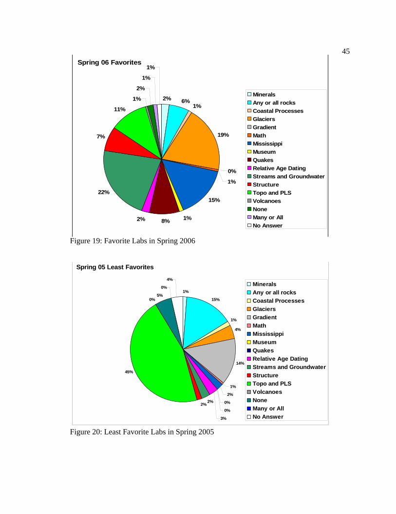
labs were favored by approximately the same percentage of students: Glaciers (19%),
Mississippi (15%), and Streams and Groundwater (22%). Four other labs were favored
by smaller percentages, but still more than most: Rock Identification (6%), Earthquakes
(8%), Structure (7%) and Topographic Maps and Public Land Survey (11%). Each of the
other labs was favored by only a small percentage (2% or fewer) of students.
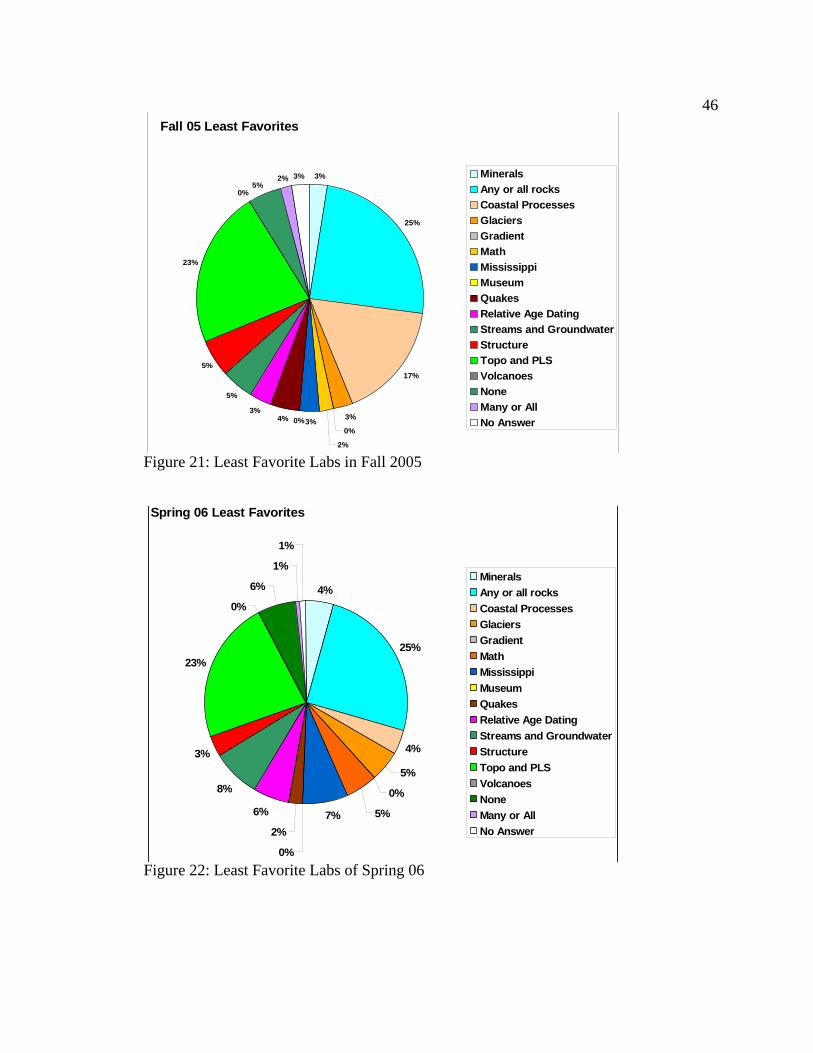
The graph of least favorite labs in the Spring 2005 semester (Fig. 20) shows that
the Topographic Maps and Public Land Survey lab was overwhelmingly disliked by 45%
of the students. Two labs were disliked by approximately equal percentages of students:
Rock Identification (15%) and Gradient (14%). Each of the other labs was disliked by
only a small percentage (5% or fewer) of students.
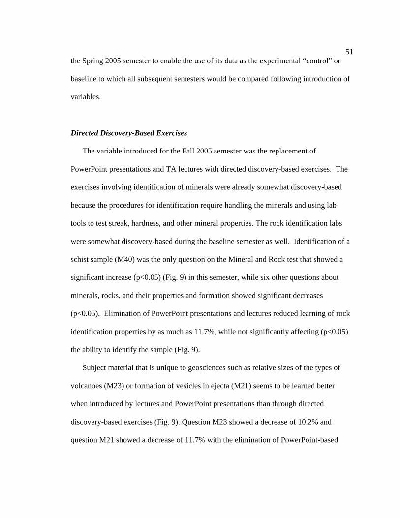
The graph of least favorite labs in the Fall 2005 semester (Fig. 21) shows that two
labs were most disliked by approximately the same percentage of students: Rock
Identification (25%) and Topographic Maps and Public Land Survey (23%). The Coastal
Processes lab was also most disliked by a rather large percentage of students (17%).
Each of the other labs was most disliked by only a small percentage (5% or fewer) of
students.
The graph of least favorite labs in the Spring 2006 semester (Fig. 22) shows that
two labs were most disliked: Rock Identification (25%) and Topographic Maps and
Public Land Survey (23%). Three labs were most disliked by a slightly elevated
percentage of students: Mississippi (7%), Relative Age Dating (6%) and Streams and
48
Groundwater (8%), while 6% of students said they did not have a least favorite lab. Each
of the other labs was most disliked by only a small percentage (5% or fewer) of students
50
CHAPTER VI
DISCUSSION
Standardization As many as 10 different TAs function as instructors and assistants in the Earth
Science I lab course each semester. Quantitative analysis of the effects of different
teaching methods required that all TAs implemented the study methods and that the test
questions used as a proxy for student learning would be the same in all sections. In her
function as Lab Coordinator, and with the approval of the professors overseeing the
course, the researcher chose the subject matter of the lessons, constructed the PowerPoint
presentations that each TA would use, wrote the pre-lab and lab exercises, and
constructed the Mineral and Rock Tests and the Final Exams, so that everything in so far
as possible would be standardized across all lab sections each semester (see Appendices
B and C). Weekly TA meetings in which the standardized material was demonstrated for
the TAs were essential in the process, as was the outline that was placed on the lectern for
use by each TA during the lab period.
Mineral and Rock Tests
Quantitative analysis of the Mineral and Rock Test questions revealed several effects
of changes in teaching methods on learning. Standardization was implemented during
51
the Spring 2005 semester to enable the use of its data as the experimental “control” or
baseline to which all subsequent semesters would be compared following introduction of
variables.
Directed Discovery-Based Exercises
The variable introduced for the Fall 2005 semester was the replacement of
PowerPoint presentations and TA lectures with directed discovery-based exercises. The
exercises involving identification of minerals were already somewhat discovery-based
because the procedures for identification require handling the minerals and using lab
tools to test streak, hardness, and other mineral properties. The rock identification labs
were somewhat discovery-based during the baseline semester as well. Identification of a
schist sample (M40) was the only question on the Mineral and Rock test that showed a
significant increase (p<0.05) (Fig. 9) in this semester, while six other questions about
minerals, rocks, and their properties and formation showed significant decreases
(p<0.05). Elimination of PowerPoint presentations and lectures reduced learning of rock
identification properties by as much as 11.7%, while not significantly affecting (p<0.05)
the ability to identify the sample (Fig. 9).
Subject material that is unique to geosciences such as relative sizes of the types of
volcanoes (M23) or formation of vesicles in ejecta (M21) seems to be learned better
when introduced by lectures and PowerPoint presentations than through directed
discovery-based exercises (Fig. 9). Question M23 showed a decrease of 10.2% and
question M21 showed a decrease of 11.7% with the elimination of PowerPoint-based
52
lectures. Recognition of grain arrangement in a sedimentary rock sample (M33)
decreased by 11.3% and identification of the compositional category of coquina (M38)
decreased by 9%, when the PowerPoint-based lectures about these rock properties were
eliminated.
Discovery-based exercises were added to the igneous and sedimentary rock labs
to enhance the identification procedures taught by traditional methods. A large, laminated
diagram that was used to place the hand samples upon to help students understand
environments of formation was added to the igneous rock lab (Fig. 23). A similar
diagram was used in the sedimentary rock lab to place the hand samples into depositional
environments (Fig. 24). Although these diagrams did not significantly (p<0.05) affect
measurable increases on the test questions, many students commented that the diagrams
made it easier to understand environments of formation and deposition.
Figure 23: Diagram for Environments of Formation of Igneous Rocks
53
Figure 24: Diagram of Depositional Environments for Sedimentary Rocks
Weekly Quizzes
Analysis of the study data shows that memorization, especially of vocabulary, is
enhanced by weekly quizzes (Fig 11). All of the significant (p<0.05) Level 1
(memorization) questions showed increases between 5.8 and 16.5% in correct responses
during the Spring 2006 semester, when quizzes were introduced. The decrease in Level 2
questions during this semester may be attributed to the fact that rock samples were not
used during the weekly quizzes, so the quizzes did not give the students additional
opportunities for recognition of rock properties. Effects of quizzes on identification of
specific rock samples are not consistent, as would be expected because the samples were
not supplied for nor tested on the quizzes.
54
Final Exams
Quantitative analysis of the Final Exam questions revealed several effects of changes
in teaching methods on learning.
Coastal Processes Take-Home Lab
Most students had difficulty learning independently from the manual outside of lab
without help from TAs. The two-day Fall Break that occurs in mid-October is
problematic for the Earth Science I Lab schedule. Classes are cancelled for Tuesday, but
held as usual on Wednesday and Thursday, the three days labs are taught. The change in
the schedule puts the Tuesday sections of the lab one week behind the other two for the
remainder of the semester. During the Fall 2005 semester, it was decided that
cancellation of all lab meetings for that week and assignment of take-home lab exercises
would keep all sections of the lab on the same weekly schedule. The Coastal Processes
Lab was chosen as the take-home exercise because the entire exercise was contained in
the lab manual and no hands-on experiment in the lab was required. The TAs felt that the
readings that precede the exercise in the manual are clear and the questions are self-
explanatory. In addition, TAs offered help at office hours for those students who wished
more explanation. Unfortunately, many of the students either did not complete the
exercise at all, or did not do well on it. During the Mississippi lab, which functions as a
review for the Final Exam and should contain merely review material, the TAs found
they spent a disproportionate amount of time explaining coastal processes, and the
percentage of correct responses on the test questions (Fig. 10, F63, F64, F68, and F69)
decreased between 13.7 and 25.7%, indicating that the concepts were not mastered to the
55
degree that they were when TAs presented the material and answered questions during
completion of the exercise in the lab. In the Spring 2006 semester, when the Coastal
Processes Lab was once again taught in the lab, 10 of 11 coastal questions (Figs. 12 and
13, F61-F69 and F96-F97) showed significant increases between 12.4 and 24.3%, as
expected.
Directed Discovery-Based Exercises
Analysis of study data and personal observations indicate that some skills and
concepts are far better taught by hands-on experience with guidance from the instructors
than by PowerPoint presentations (Fig. 10). For example, use of geologic maps (F23)
increased by 9.6%, understanding of stream processes (questions F44 and F45) increased
by 8.8 and 8% respectively, and understanding of glacial processes (F74 - F77) increased
between 9.7 and 40.3% with the introduction of directed discovery-based exercises.
Glacial processes in particular tend to be difficult concepts to convey to Mississippi
students, many of whom have never even seen snow. Significant increases (p<0.05) in
all four of the questions (F74 - F77) clearly shows that use of the “slime glacier” (Fig. 25)
to demonstrate the way a valley glacier moves and how moraines and piedmont glaciers
are formed greatly enhanced understanding of glacial processes.
56
Figure 25: The “Slime” Glacier is demonstrated in front of the lab.
56
57
Analysis of data shows that directed discovery-based learning enhances learning
of some concepts, but not necessarily vocabulary. Geologic structures were taught with a
directed discovery-based exercise involving Crayola Model Magic® (Appendix C).
Students used the modeling compound to simulate folds of various types (Fig. 26 & 27)
and then diagrams in the book to correlate them to the geologic structures formed by the
same stresses in ductile rocks. Wooden blocks (Fig. 28) were used to demonstrate the
various types of faults and the stresses that produce them. It appeared during the lab
session that the students were grasping the concepts of the types of stresses and their
resultant structures, yet decreases of 10.7% and 12.9% show that the concepts were not
paired with the related vocabulary (Fig.10, F12 and F15).
Figure 26: Students use Model Magic® to simulate the results of various stresses on ductile rocks.
58
Figure 27: The “rocks” elongate and thin in response to application of continued stress.
Figure 28: Students discover the direction of movement along a reverse fault as a result of compressional stress.
59
Most and Least Favorite Labs
Hands-on activities made the labs more enjoyable for the students while maintaining
learning percentages comparable to the baseline. During the Fall 2005, when directed
discovery-based exercises were first introduced, the students responded positively to the
hands-on activities (Fig. 19), with 21% citing the Topographic Maps and Public Land
Survey Lab, 19% choosing the Mississippi Lab, 16% naming the Streams and
Groundwater Lab, and 9% citing the Geologic Structure Lab as a favorite. The contour
box exercise (Figs. 29 - 31) in the maps lab, the flume experiments (Figs. 32 - 34), the
“slime glacier” (Figs 26), and the Model Magic exercises (Figs. 27 & 28) in the structure
lab were cited most often as the reasons these labs were favored. If the lab experience is
more fun for the students without an accompanying decrease in learning, then the
addition of the exercises can be considered an improvement.
Figure 29: Students pour colored water into a contour box as the first step in creating a topographic map on the lid of the box.
60
Figure 30: After each consecutive centimeter of water is added, students draw the contact
between the water and the volcano onto the lid with an erasable marker.
Figure 31: When the volcano is submerged, the final topographic map is complete.
61
Figure 32: Students adjust the hose until the water level remains constant to simulate stream flow in the flume
Figure 33: As the colored, salty, ice water is added upstream, the pollution flows along
the bottom of the flume.
62
Figure 34: Students must actively participate to see the high-density water that simulates
a pollution front in the lower part of the flume.
The labs cited most often as favorites in the experimental semesters were those in
which the students could recognize relevance to their daily lives. The Mississippi Lab
was popular with students, many of whom stated that they enjoyed learning new
information about their home state. Many students also commented that they enjoyed the
Earthquake Lab because they did not know that earthquakes could occur in Mississippi or
what type of land they should avoid when building a home. Other students found the
Streams and Groundwater Lab interesting because they learned about the hazards of
pollutants at the bottom of streams (Fig. 32 – 34) where the catfish live (Appendix C).
The lab exercises that were cited as least favorites throughout the course of the
study were those that the students perceived as either too difficult to understand or
63
irrelevant to their lives outside the lab. Map Labs were overwhelmingly disliked (45%)
until the introduction of the contour boxes (Fig. 29 – 31), which the students enjoyed
working with and which enhanced their understanding of three-dimensional visualization.
Because the students found the take-home format difficult during the Fall 05 Semester,
the Coastal Processes Lab was reported as least favorite by 17% of students. When the
lab was taught in the classroom the following semester, it returned to 4%, much closer to
its baseline level. The nearly constant level of 20-25% of students citing Mineral and
Rock Labs as their least favorite is explained by their perception that the material is
irrelevant. The students who chose these as their least favorites most often said that rocks
were boring, and they just didn’t care about rocks.
Inherent Limitations of the Study Human Subjects
Inherent in any study involving human subjects are inconsistencies that cannot be
controlled by the researcher. In this study, there were two sets of human subjects whose
behavior was crucial to the outcome of the study, the students and the TAs. Most of the
problems associated with the students were adequately eliminated by the large size of the
sample and its demographic representation of the undergraduate student body as a whole.
On the other hand, the small group of TAs who taught the course and their direct
involvement in the teaching of the labs and writing of the quizzes was less easily
controlled by the researcher. The position of Lab Coordinator allowed some degree of
control. However, it must be recognized that this is not a position of authority, but
requires voluntary cooperation from the TAs. Also, the TAs had different amounts of
64
teaching experience, so they followed directions with varying degrees of accuracy and
enthusiasm. Overall, the standardization appears to have been a success.
Hurricane Katrina
Hurricane Katrina had several negative effects on the Earth Science I Lab. Lab
sessions were cancelled during the week the storm hit the Mississippi coast, which
resulted in a slightly reduced curriculum and the elimination of the “slime glacier”
demonstration in the Fall 2005 semester. In addition, several students from other
universities near the coast entered the course several weeks into the semester and needed
to work with TAs to get caught up to date with the course. Some material (particularly
minerals and igneous rocks) may have been learned in less detail as a result. Many of the
students already at MSU had loved ones and homes more directly affected by the storm,
so absenteeism and distraction from concentration on studies were common through
September and October of 2005.
Hurricane Katrina had the positive effect of stimulating curiosity about coastal
processes for many students who might otherwise have had little interest. Comparison of
satellite photographs of the Mississippi coast and barrier islands before and after the
storm (Figs. 35 and 36) were used in the lab as a directed discovery-based activity, and
many students lingered over the photographs and discussed them at length. This would
suggest that it would be advantageous for the students to have access to a sand and water
table that could be used to demonstrate coastal processes to encourage the heightened
interest to continue.
65
Figure 35: The Mississippi Coast before Hurricane Katrina (July 8, 2000).
Figure 36: The Mississippi Coast after Hurricane Katrina (October 18, 2005).
66
Conclusions and Recommendations Standardization
It is recommended that standardization should be attempted for all courses with large
enough enrollments to require several sections taught by different instructors.
Standardization of large-enrollment lab courses allows careful analysis of the effects of
changes made to improve the course. The data set used in this study included 150 - 200
students in each of the three semesters, each responding to a total of 151 questions,
yielding over 82,000 individual responses to test questions to be used as data points.
Such a large data set for quantitative analysis would not be possible in only three
semesters without standardization that allowed equal treatment of all sections.
PowerPoint-Based Lectures
Lectures and PowerPoint presentations increase learning of some key elements of
geoscience subject matter; they should be used to convey basic information upon which
the laboratory exercises can build. Photographs and diagrams drawn from many sources
and included in PowerPoint presentations can enhance the understanding of the subject
material by providing students with ideal images and numerous illustrative examples.
Pre-Lab Exercises
Significant improvement (p<0.05) in learning as a response to the addition of pre-lab
exercises was not found in this study; use should be limited or discontinued. Students
were often observed completing the pre-lab exercises in the 5 or 10 minutes immediately
preceding lab, so the exercise was completed with little attention paid to what was being
written and with no time to review it for understanding. More extensive pre-lab exercises
67
that require reading and absorption of the material from the manual prior to use in the lab
might show different results.
Directed Discovery-Based Exercises
Directed discovery-based learning is useful and increases learning and enjoyment
of the lab for many of the students according to their answers to questions #98 and 99 on
the Final Exam; hands-on activities should be used in the lab to enhance understanding
and morale. TAs reported having a better time in lab and experiencing a more positive
attitude in general from their students with the addition of the hands-on activities. TAs
reported being asked, “What are we doing today?” with a more enthusiastic tone of voice
than in the baseline semester. In addition, it is recommended that exams be redesigned so
that questions focus more on testing concepts rather than vocabulary to fairly assess the
success of the activities.
Weekly Quizzes
Weekly quizzes increase memorization of vocabulary and may improve higher-level
learning as well; they should be used whenever feasible. Addition of weekly quizzes to
the curriculum resulted in increases on 34 of 42 significant questions (p<0.05).
Maximization
Cumulative effects will be maximized by the simultaneous use of all of these teaching
tools. Different students respond to different teaching methods. Use of a variety of
approaches to the dissemination of geoscience information to mostly novice non-major
should yield the greatest learning.
68
CHAPTER VII
CONCLUSIONS
• Elimination of PowerPoint presentations and lectures reduced learning of rock
properties by as much as 17.6%
• Some subject material that is unique to geosciences is learned 9-12.9% better
when introduced by lectures and PowerPoint presentations than through directed
discovery-based exercises.
• Most students had difficulty learning independently from the manual outside of
lab without help from TAs. Learning of material reduced by 13.7-25.7% when
students did not have classroom instruction.
• Some skills and concepts are far better taught by hands-on experience with
guidance from the instructors than by PowerPoint presentations. Discovery-based
exercises increased understanding of geologic maps by 9.6%, stream processes by
8-8.8%, and glacial processes by 9.7 – 40.3%.
• Directed discovery-based learning enhances learning of concepts, but not
necessarily vocabulary.
• Learning of vocabulary was not improved with pre-lab exercises, but was
increased by 4 – 20% with the addition of weekly quizzes.
69
• Learning of materials at all three learning levels was increased by 4-38.3% with
weekly quizzes.
• Hands-on activities made the labs more enjoyable for 25-30% of the students
while maintaining learning percentages comparable to the baseline.
• The labs cited most often 35-38% as favorites in the experimental semesters were
those in which the students could recognize relevance to their daily lives.
70
REFERENCES American Geological Institute and National Association of Geoscience Teachers, 2006.
Laboratory Manual in Physical Geology, Seventh Edition. Pearson-Prentice Hall, Upper Saddle River, NJ. 302 p.
Baker, Don R., Dalpé, Claude, and Poirier, Glenn, 2004. The Viscosities of Foods as
Analogs for Silicate Melts. Journal of Geoscience Education, v.52, n.4, p.363-367. Bowd, Alan D, 1989. Dissection as an Instructional Technique in Secondary Science:
Choice and Alternatives. Lakehead University, Canada. www.animalliberationfront.com, accessed 11/28/05.
Burt, James E. and Barber, Gerald M., 1996. Elementary Statistics for Geographers, 2nd
ed. The Guilford Press, New York, NY. 640 p. Button, Leslie, 1971. Discovery and Experience: A New Approach to Training, Group
Work, and Teaching. Oxford University Press, New York, NY. 222 p. Calderone, Gary J., Thompson, J. Robert, Johnson, Wayne M., Kadel, Steve D., Nelson, Pamela J., Hall-Wallace, Michelle, and Butler, Robert F., 2003. GeoScape:
An Instructional Rock Garden for Inquiry-Based Cooperative Learning Exercises in Introductory Geology Courses. Journal of Geoscience Education, v51, n2, p.171-176.
Carin, Arthur A, and Bass, Joel E., 2001. Methods for Teaching Science as Inquiry,
eighth ed., Prentice- Hall, Inc., Upper Saddle River, N.J. 371 p. Carin, Arthur A., 1997. Teaching Science Through Discovery, eighth ed., Prentice- Hall,
Inc., Upper Saddle River, N.J. 235 p. Carin, Arthur A, and Bass, Joel E., 2001. Teaching Science as Inquiry, ninth ed.,
Prentice- Hall, Inc., Upper Saddle River, N.J. 249 p. Castronova, Joyce A, 2002. Discovery Learning for the 21st Century: What is it and how
does it compare to traditional learning in effectiveness in the 21st Century? Action Research Exchange, v.1, n.1. http://chiron.valdosta.edu/are/Artmanscrpt/vol1no1/castronova_am.pdf, accessed 11/14/2005.
Chiappetta, Eugene L. and Adams, April D., 2004. Inquiry-Based Instruction: Understanding how content and process go hand-in-hand with school science. The Science Teacher, Feb, 2004, p. 46-50.
2004, p.63-66. Dewey, Dr. Christopher, 2005. Coach Education Program, Level One Manual. United
States Judo Association, Fifth Estate, Blountsville, AL. 153 p. Downing, Jan, E, 1993. An Investigation of Preservice Teachers’ Science Process Skills
and Attitude to the Use of Questioning Strategies n a Demonstration Science Discovery Lesson. Mississippi State University, Mississippi State, MS. 77 p.
Guertin, Laura A., 2005. An Indoor Shopping Mall Building Stone Investigation with
Handheld Technology for Introductory Geoscience Students. Journal of Geoscience Education, v.53, n.3, p.253-256.
Hannula, Kinberly A, 2003. Revising Geology Labs to Explicitly Use the Scientific
Method. Journal of Geoscience Education, v.51, n.2, p. 194-200. Harpp. Karen S., Koledzar, Alison M, and Geist, Dennis J., 2005. Volcanoes in the
Classroon: A Simulation of an Eruption Column. Journal of Geoscience Education, v.53, n.2, p.173-175.
Harris, Mark T., 2002. Developing Geoscience Student-Learning Centered Courses.
Journal of Geoscience Education, v.50, n.5, p.515-523. Hendrix, Gertrude, 1961. Learning by Discovery. Mathematics Teacher, v.54. p.290-
299. Hofstein, Avi and Lunetta, Vincent N., 2004. The Laboratory in Science Education:
Foundations for the Twenty-First Century. Science Education, v.88 n.1 p.28-54. Johnson, Donald M, Wardlow, George W., and Franklin, Timothy D., 1998. Method of
Reinforcement and Student Gender: Effects on Achievement in Agriscience Education. Journal of Agricultural Education, v.39, n.4, p. 18-27.
Kirkland, Brenda L., 2006. Personal communication. Kuslan, Louis I, 1968. Teaching Children Science: An Inquiry Approach. Wadsworth
Publishing Co., Belmont, CA. 464 p.
72
Leech, Mary L., Howell, David G., and Egger, Anne E., 2004. A Guided Inquiry Approach to Learning the Geology of the U.S. Journal of Geoscience Education, v.52, n. 4, p. 368-373.
Libarkin, Julie C. and Anderson, Steven W, 2005. Assessment of Learning in Entry-
Level Geoscience Courses: Results from the Geoscience Concept Inventory. Journal of Geoscience Education, v. 53, n. 4, p. 395-401.
MacDonald, R. Heather, Manduca, Cathryn A., Mogk, David W., and Tewksbury,
Barbara J., 2005. Teaching Methods in Undergraduate Geoscience Courses: Results of the 2004 On the Cutting Edge Survey of U.S. Faculty. Journal of Geoscience Education, v.53, n.3, p.237-252.
McConnell, David A., Steer, David N., and Owens, Kathie D, 2003. Assessment and
Active Learning Strategies for Introductory Geology Courses. Jornal of Geoscience Education, v. 51, n, 2, p. 205 – 216.
McConnell, David A., Steer, David N, Owens, Katherine D., and Knight, Catherine C.,
2005. How Students Think: Implications for Learning in Introductory Geoscience Courses. Journal of Geoscience Education, v. 53, n. 4, p. 462-470.
Morine, Harold and Morine, Greta, 1973. Discovery: A Challenge to Teachers. Prentice-
Hall, Englewood Cliffs, N.J. 242 p. Mylroie, John E, 1978. Student participation in a P- and S-wave demonstration. The
Physics Teacher, Oct. 1978, p. 479-480. National Research Council of the National Academies, 2005. America’s Lab Report:
Investigations in High School Science. The National Academic Press, Washington, D.C., http://fermat.nap.edu/books/0309096715/html/, accessed 1/10/05.
Paul, Richard W., 1995. Critical Thinking: How to Prepare Students for a Rapidly
Changing World. Foundation for Critical Thinking, 572 p. Pitz, Albert and Sund, Robert, 1974. Creative Teaching of Science in the Elementary
School, 2nd ed. Allyn and Bacon, Boston, MA. 310 p. Rehorek, Susan J, 2004. Inquiry-Based Teaching: An Example of Descriptive Science in
Action. The American Biology Teacher, v.66, n.7, p.493-499. Schmidt, Victor E. and Verne N. Rockcastle, 1968. Teaching Science With Everyday
School of Science and Mathematics, 2004. Assessing Investigative Skills. v.104(6), p. 249-257.
Schulman, Lee S. and Keislar, Evan R., 1966. Learning by Discovery: A Critical
Appraisal: Proceeding of a conference on Learning by Discovery. Rand McNally & Co, Chicago, IL. 224 p.
Science Education Resource Center (SERC) @ Carleton College, 2006. How to Use the
Socratic Method in the Classroom. Starting Point – Teaching Entry Level Geoscience website. http://serc.carleton.edu/introgeo/socratic/fourth.html Last modified March, 2006. Accessed 4/28/2006.
University of North Carolina at Chapel Hill (UNC-CH), 2001. Teaching for Inclusion.
Center for Teaching and Learning website, http://ctl.unc.edu/tfi1.html Last updated, 1/30/2001. Accessed 4/28/2006.
Wittrock, M.C., 1966. The Learning by Discovery Hypothesis. in Shulman, Lee S. and
Evan R. Keislar, Editors. Learning by Discovery: A Critical Appraisal: Proceeding of a conference on Learning by Discovery. Rand McNally&Co., Chicago,IL. 224p.
BEFORE SUBMITTING YOUR PROTOCOL FOR IRB REVIEW, MAKE SURE YOU HAVE INCLUDED THE FOLLOWING (IF APPLICABLE):
____Survey, Questionnaire or Interview Questions ____Consent and Assent forms ____Recruiting materials ____Permission letters from participating institutions ____Signed Investigator Assurance form ____Clear, concise description of procedures to be used (Feel free to also attach any proposals that may further explain your project.) Additionally, these assurances must be made: ____All personnel listed must have completed IRB/Human Subjects Training. If not, your application cannot be approved until the training has been completed. See our website for training dates and times. http://www.msstate.edu/dept/compliance/irb/irbregistration.htm ____If applicable, the advisor has thoroughly reviewed this application to ensure readability and accuracy.
PLEASE NOTE:
• THE DETERMINATION OF THE IRB WILL BE COMMUNICATED TO YOU IN WRITING. SUBMISSION OF AN APPLICATION TO THE IRB DOES NOT EQUAL IRB APPROVAL. YOU MAY NOT BEGIN THIS RESEARCH UNTIL
YOU HAVE IRB APPROVAL.
• IF YOUR RESEARCH HAS NOT YET RECEIVED FUNDING NEEDED TO CREATE INSTRUMENTS AND OTHER ASSOCIATED MATERIALS,
PROVIDE A TIMELINE OF WHEN THOSE ITEMS WILL BE DEVELOPED. YOUR APPLICATION WILL BE REVIEWED FOR “118 DESIGNATION”(SEE http://www.msstate.edu/dept/compliance/irb/irbawardchanges.htm FOR MORE
INVESTIGATOR'S ASSURANCE Mississippi State University Institutional Review Board
Project Title: Improving Teaching of Earth Science I Lab As Primary Investigator, I have ultimate responsibility for the performance of this study, the protection of the rights and welfare of the human subjects, and strict adherence by all co-investigators and research personnel to all Institutional Review Board (IRB) requirements, federal regulations, and state statutes for human subjects research. I hereby assure the following: The information provided in this application is accurate to the best of my knowledge. All named individuals on this project have been given a copy of the protocol and have acknowledged an understanding of the procedures outlined in the application. All experiments and procedures involving human subjects will be performed under my supervision or that of another qualified professional listed on this protocol. I understand that, should I use the project described in this application as a basis for a proposal for funding (either intramural or extramural), it is my responsibility to ensure that the description of human subjects use in the funding proposal(s) is identical in principle to that contained in this application. I will submit modifications and/or changes to the IRB as necessary to ensure these are identical. I and all the co-investigators and research personnel in this study agree to comply with all applicable requirements for the protection of human subjects in research including, but not limited to, the following: • Obtaining the legally effective informed consent of all human subjects or their legally authorized
representatives, and using only the currently approved, consent form (if applicable); and • Making no changes to the approved protocol or consent form without first having submitted those
changes for review and approval by the Institutional Review Board; and • Reporting serious and unexpected adverse effects to IRB Administration verbally within 48 hours and
in writing within 10 days of occurrence, and all other unexpected adverse events in writing within 10 days of occurrence; and
• Promptly providing the IRB with any information requested relative to the project; and • Promptly and completely complying with an IRB decision to suspend or withdraw its approval for the
project; and • Obtaining continuing review prior to the date approval for this study expires. I understand if I fail to
apply for continuing review, approval for the study will automatically expire, and study activity must cease until IRB current approval is obtained.
• Your study and any associated records may be audited by the IRB to ensure compliance with the approved protocol.
Name of Primary Investigator / Researcher: Julia G. Johnston Signature: I assume responsibility for ensuring the competence, integrity and ethical conduct of the investigator(s) for this research project. The investigator(s) is/are fully competent to accomplish the goals and techniques stated in the attached proposal. Further, I certify that I have thoroughly reviewed this application for readability and accuracy and the study is clearly described herein.
78
Name of Advisor: Dr. Brenda L. Kirkland Signature: THE MISSISSIPPI STATE UNIVERSITY INSTITUTIONAL REVIEW BOARD
FOR THE PROTECTION OF HUMAN SUBJECTS IN RESEARCH
Protocol Submission Form
PRINCIPAL INVESTIGATOR / RESEARCHER INFORMATION Name: Julia Johnston
Daytime Phone Number: 325-2913 Mailing Address: 1206 Seventh Street North If on-campus, provide Mailstop
City/State/Zip: Columbus, MS 39701 E-Mail Address: [email protected]
Department: Geosciences IRB and Human Subjects Protections Education completed on 11/01/04.
FACULTY ADVISOR (Faculty member supervising the student for this project) If you are a student, you must have an advisor for this project. Advisor: Dr. Brenda L. Kirkland
• As principal investigator, it is your responsibility to ensure that all individuals conducting procedures described in this application are adequately trained prior to involving human participants.
• All personnel listed on this application are required to successfully complete the MSU IRB & Human Subjects training course or an MSU IRB approved alternative. APPROVAL WILL NOT BE GRANTED UNTIL ALL INDIVIDUALS HAVE COMPLETED THIS TRAINING.
• As personnel change, you must submit a modification request to the IRB for approval before they can work with human subjects or identifiable or confidential information.
A. Including yourself, provide the name of each individual who will be responsible for
the design or conduct of the study, have access to human participants, or have access to identifying or confidential information. Julia Johnston Dr. Brenda Kirkland Dr. John Mylroie Dr. Christopher Dewey
B. For each person identified above, identify his/her role in the project and clearly state the procedures or techniques he/she will be performing. Julia Johnston is Graduate Student who will be Primary Researcher. Dr. Kirkland, Dr. Mylroie, and Dr. Dewey are graduate advisors on thesis.
II. Research Protocol
1. SITE OF WORK: All labs are taught at quizzes and tests administered in the Earth Science I Lab, 304
Hilbun Hall, MSU Campus. All tabulation of data will be done in Researcher’s office on Graduate Student Office Computer. Follow-up assessment will also be conducted in 304 Hilbun Hall.
2. Brief description of the GENERAL PURPOSE of the project: In your view, what BENEFITS may result from the study that would justify asking
the subjects to participate? The study is to be conducted as a thesis for Master’s Degree in Geosciences and possible publication. The main benefit of the study is to determine the most effective teaching methods to improve student learning and retention of the Earth Science I Lab material. The intention is to fine-tune teaching methods to make the lab more interesting and enjoyable to the students while improving their overall understanding of the subject matter.
3. Give details of the PROCEDURES that relate to the subjects' participation, include
at a minimum the following information (append additional page(s) if necessary):
80
a) List ALL vulnerable subject populations to be included and additional
precautions being taken to ensure their protection. No special precautions should be necessary, as the students will simply be taking part in their regular lab activities.
b) How will the subjects be selected and recruited? Subjects will include all students who enroll in Earth Science I Lab and sign a consent form for the use of their grades. Recruitment for follow-up study will be included in the consent form. Those agreeing to be contacted for follow-up study will be contacted by e-mail to be informed of time of follow-up study.
c) What inducement will be offered?
For the main study, simply the chance to participate in the improvement of the Lab for future students. For those who agree to the follow-up study, a coupon for $1-2 for use at a fast-food restaurant will be purchased from personal funds and given to participants as an incentive for their participation.
d) How many subjects will be used? List any salient characteristics of subjects, i.e.,
age range, sex, institutional affiliation, other pertinent characterizations. I anticipate the enrollment of approximately 280-300 students during a Spring or Fall semester, with approximately 20-30 students in the Summer Lab session. I anticipate a high percentage (90-95%) will consent to use of their grades. I anticipate approximately 30-50 students will participate each semester in the follow-up study, maybe 3-5 of the summer students to participate in the follow-up.
e) Number of times researchers will interact with each subject? 10-15 times. f) What will the subjects do, or what will be done to them, in the study?
Subjects will participate in their regular lab course curriculum. Only those who volunteer for the follow-up study will be asked to do anything additional.
4. How do you intend to obtain the subjects' INFORMED CONSENT?
Attached consent form will be given to each student with the syllabus on the first day of lab each semester, to be signed and returned before they leave the classroom that day. For the first semester (Fall/2004) this consent form will be given to the students on Final Exam day, to be signed and returned before leaving the lab that day.
5. Assessment of RISK
I anticipate no risk whatsoever, as all students will be participating in their regular coursework and strict confidentiality will be maintained.
6. How do you ensure CONFIDENTIALITY of information collected? At a minimum, provide the following information:
Who will have access to the data? Where will data be stored? Where will signed consent forms be stored (be specific regarding location)? What identifiers (direct or indirect) will be collected? What purpose do the identifiers serve? When will identifiers be removed or “de-linked” from the data? (Identifiers include a code
81
number, which may be linked to another document containing names or other identifying information.) Will the data be retained or destroyed? If the data will be destroyed, how and at what point in time?
Access to the data will be limited to the Graduate Teaching Assistants for the course and the Graduate Committee named above. All data will be in statistical form only, and no names of subjects will be reported. All quizzes and tests are stored in Graduate Teaching Assistants’ offices in the Geosciences department. Signed consent forms will be stored in the Researcher’s Office. Names of students will be used as identifiers for comparison to follow-up data, but will be removed before when data is tabulated. Individual scores will never be used in final reports, only averages and percent increases or decreases in those averages will be reported or published.
7. Are approvals needed from another MSU regulatory committee (i.e. IACUC for animals or IBC for infectious agents or recombinant DNA)? If so, please attach approval letter(s) from appropriate committee(s). If approval has not yet been obtained, where are you at in the approval process?
N/A
82
CONSENT FORM FOR RESEARCH STUDY
Title of Study: Improving Teaching of Earth Science I Lab Study Site: MSU Earth Science I Lab, 304 Hilbun Hall Name of Researcher(s) & University affiliation: Julia Johnston, Graduate Student and Dr. Brenda Kirkland, Assistant Professor of Geosciences What is the purpose of this research project? To improve the Earth Science I Lab to make it more fun and interesting, making the material easier for the students to learn and retain. How will the research be conducted? Lab assignment, quiz, and test scores will be used to decide where changes should be made and comparisons of the grades from one semester to others will be used to assess what effect the changes have resulted in. Volunteers will also participate in a short follow-up study to determine retention after the coursework has been completed. A fast-food coupon will be offered as incentive for participation in the follow-up study. Are there any risks or discomforts to me because of my participation? None. Does participation in this research provide any benefits to others or myself? None, other than the improvements made to the course for future students of the Earth Science I Lab and the possible incentive for follow-up assessment. Will this information be kept confidential? All information will be in the form of statistics only. No grades or answers to questions
will be linked to a particular student. No names of students will be used in any way in
the reporting of the data. Full confidentiality will be maintained.
Who do I contact with research questions? If you should have any questions about this research project, please feel free to contact Julia Johnston at 325-2913 or by e-mail at [email protected]. The Instructor for the course and graduate advisor for this project is Dr. Brenda L. Kirkland, who can be reached at 325-2911 or by e-mail at [email protected]. For additional information regarding your rights as a research subject, please feel free to contact the MSU Regulatory Compliance Office at 662-325-3294. What if I do not want to participate?
Please understand that your participation is voluntary, your refusal to participate will involve no penalty or loss of benefits to which you are otherwise entitled, and you may discontinue your participation at any time without penalty or loss of benefits. Whether or not you choose to participate in this study will have NO EFFECT ON YOUR GRADE IN THIS COURSE. Name (Please Print) _____________________________ __________ Participant Signature Date ________________________________ __________ Investigator Signature Date
84
If you would be willing to allow me to use your digital photograph in my thesis, for projection, on a poster, or for publication, please sign below. Name (Please print)________________________________________________________ Signature _______________________________________________________ Date ________________ If you would be willing to give me less than a hour of your time for a follow-up study 3-4 months after your final exam, please give me your e-mail address and/or phone number so that I may contact you. I will offer you a coupon for a discount at a fast-food restaurant to thank you for your time and for your participation in this follow-up. Name (Please Print)______________________________________________ e-mail address_________________________________________________________________ phone # _________________________________________________________________________
85
APPENDIX B
TESTS
86
MINERAL AND ROCK TEST – SPRING AND SUMMER 2005 Version A - KEY
1. What color is the streak for mineral J? (Pyrite) A) White B) Dark Gray C) Green D) Yellow E) Pink 2. Identify mineral J. A) Graphite B) Galena C) Plagioclase Feldspar D) Olivine E) Pyrite 3. Mineral J has which type of luster? A) Metallic B) Non-Metallic C) Hard D) Soft 4. Is mineral K hard or soft? (K-spar) A) Hard (>5 on Moh’s scale) B) Soft (<5 on Moh’s scale) 5. Identify mineral K. A) Pyrite B) Olivine C) Talc D) Sulfur E) Potassium Feldspar 6. “The shape that crystals for a mineral will have with sufficient room and time to grow”
is the definition of: A) Color B) Luster C) Streak D) Cleavage E) Crystal form
87
7. Which tool is used to identify mineral hardness? A) White Streak plate B) Magnet C) Glass plate D) Black Streak Plate E) A & D 8. What is the hardness of mineral I? (Calcite) A) Hard (>5 on Moh’s scale) B) Soft (<5 on Moh’s scale) 9. What is the streak of mineral I? A) White B) Black or dark gray C) Yellow D) Green E) Absent 10. What type of cleavage does mineral I exhibit? A) Basal B) Rhombohedral C) Cubic D) Conchoidal D) No cleavage 11. Which one of the following is not one of the “Big 6” common mineral properties? A) Color B) Reaction to hydrochloric acid C) Crystal form (habit) D) Cleavage/Fracture E) Streak 12. For which mineral is color not a reliable diagnostic property? A) Sulfur B) Galena C) Quartz D) Olivine E) Pyrite 13. Identify igneous rock L.(Diortie) A) Obsidian B) Diorite C) Pumice D) Gabbro E) Andesite
88
14. What is the extrusive equivalent of rock L? A) Basalt B) Andesite C) Rhyolite D) Scoria 15. What texture below indicates an igneous rock as intrusive in origin? A) Phaneritic B) Aphanitic C) Porphyritic D) Glassy E) Vesicular 16. What is the composition of igneous rock M?(Basalt) A) Felsic B) Intermediate C) Mafic D) Ultramafic 17. What is the texture of igneous rock N?(Pumice) A) Phaneritic B) Aphanitic C) Porphyritic D) Glassy (the book also says this, so accept it, but we prefer vesicular) E) Vesicular 18. Extrusive rocks form: A) from magma above the surface B) from lava above the surface C) from magma below the surface D) from lava below the surface 19. The texture of igneous rock N indicates what kind of origin? A) Intrusive igneous rock B) Extrusive igneous rock 20. What type of composition does an igneous rock have if it is composed mainly of light
colored minerals (>85%)? A) Felsic B) Intermediate C) Mafic D) Ultramafic
89
21. Identify igneous rock O.(Granite) A) Pumice B) Granite C) Rhyolite D) Andesite E) Scoria 22. Felsic magmas are formed by the partial melting of which type of crust? A) Oceanic crust B) Continental Crust C) Island Crust D) Bread Crust 23. Vesicles form from: A) Chunks of rock floating in magma B) Gasses escaping from lava C) Minerals dissolving D) Air forcing its way into lava 24. Porphyritic texture is a result of: A) Fast cooling at the surface B) Slow cooling below the surface C) Slow cooling at first, followed by fast cooling later D) Instantaneous cooling under the sea 25. Which type of volcano is the largest? A) Cinder cone B) Composite volcano C) Shield volcano 26. Which type of lava forms shield volcanoes? A) Felsic B) Intermediate C) Mafic D) Ultramafic 27. In an igneous rock, what does composition describe? A) Refers to the different types of minerals in the rock B) Describes the location where the rock was found C) The rock’s protolith (parent rock) D) The size, shape, and arrangement of the rock’s constituent parts
90
28. The presence of fossils indicates which type of rock? A) Igneous B) Sedimentary C) Metamorphic D) Mineral 29. Identify sedimentary rock P. (Fossiliferous Limestone) A) Sandstone B) Shale C) Chert D) Fossiliferous Limestone E) Conglomerate 30. What compositional category does sedimentary rock Q belong to? (Coquina) A) Detrital B) Biochemical C) Chemical 31. Sandstones are composed mostly of what mineral? A) Augite B) Quartz C) Basalt D) Pyrite 32. Identify sedimentary rock R. (Sandstone) A) Coquina B) Breccia C) Sandstone D) Chalk E) Chert 33. What is the grain arrangement for sedimentary rock S?(Breccia) A) Poorly sorted B) Moderately sorted C) Well sorted 34. What is the grain (sediment) size of sedimentary rock S? (Hint: Look at the largest
sediment). A) Gravel B) Sand C) Silt D) Clay
91
35. Where does the sedimentary rock coal form? A) Beaches B) Deep Ocean C) Streams D) Swamps E) Mountains 36. Where does the sediment that forms sandstone come from? A) Mechanical/chemical weathering of pre-existing rock B) Secretions from reef-dwelling creatures C) Swamps (decaying plant life) D) Precipitation from seawater E) Fossil remains 37. The only difference between conglomerates and breccias is that conglomerates have
rounded gravel-sized sediments and breccias have angular gravel-sized sediments. What does the shape of the sediments reveal about these two sedimentary rocks? A) The sediments in the breccia traveled much farther from their source than the
sediments in the conglomerate. B) The sediments in the conglomerate traveled much farther than the
sediments in the breccia. C) The conglomerate sediments were transported by a small stream, while the
breccia sediments were transported by a large river. D) The sediments in the conglomerate came from igneous rock, while the
sediments in the breccia came from metamorphic rock. E) The shape of the sediment grains doesn’t reveal anything 38. Which sedimentary rock is formed by the precipitation of dissolved minerals from
solution (ocean water)? A) Breccia B) Sandstone C) Chalk D) Chert E) Coquina 39. Identify metamorphic rock T. (Marble) A) Marble B) Gneiss C) Schist D) Quartzite E) Slate
92
40. What is the parent rock (protolith) for Quartzite? A) Limestone B) Slate C) Granite D) Sandstone E) Shale 41. Metamorphic Grade means: A) Parent rock B) Intensity of metamorphism C) Mineral composition D) Grain size 42. Identify metamorphic rock U. (Schist) A) Gneiss B) Schist C) Slate D) Quartzite E) Marble 43. What is the general texture for metamorphic rock U? A) Foliated B) Unfoliated C) Phaneritic D) Aphanitic 44. This rock is the parent rock for Slate, Phyllite, Schist, and Gneiss.
A) Limestone B) Sandstone C) Shale D) Conglomerate E) Basalt
93
Matching: Choose one of the following for the question below. Letters MAY BE used more than once. A) Mineral B) Igneous Rock C) Sedimentary Rock D) Metamorphic Rock E) Igneous, Sedimentary, and Metamorphic Rock 45. Forms from weathered (chemical or mechanical) fragments of rock, consisting of
remains or secretions of plants/animals, or precipitation. C 46. An inorganic, naturally occurring substance that has a characteristic chemical
composition, distinctive physical properties, and crystalline structure. A 47. Forms from molten rock (magma or lava). B 48. What type of rock can be changed by a metamorphic event? E 49. Forms by changing from one form to another by intense heat, intense pressure, or the
action of hot watery fluids. D 50. The basic building-block of all rocks. A
94
MINERAL AND ROCK TEST – FALL 2005 Version A - KEY
1. What color is the streak for mineral A (Sulfur)? A) White B) Dark Gray C) Green D) Yellow E) Pink 2. Mineral A has which type of luster? A) Metallic B) Non-Metallic C) Hard D) Soft 3. Identify mineral A. A) Graphite B) Galena C) Plagioclase Feldspar D) Sulfur E) Pyrite 4. Is mineral B hard or soft? (Talc) A) Hard (>5 on Moh’s scale) B) Soft (<5 on Moh’s scale) 5. Identify mineral B. A) Pyrite B) Olivine C) Talc D) Sulfur E) Potassium Feldspar 6. Which one of the following is not one of the 6 common properties we used to identify
minerals? A) Color B) Reaction to hydrochloric acid C) Luster D) Cleavage E) Streak
95
7. Which tool(s) is/are used to identify mineral hardness? A) Glass plate B) Iron Nail C) Penny D) Fingernail E) All of the above 8. What is the hardness (from Moh’s Scale) of mineral C? (Fluorite) A) Hard >5 B) 4 C) 3 D) <2.5 9 What is the streak of mineral C? A) Black B) White C) Green D) Pink E) Absent 10. The cleavage of mineral X is: (Mica) A) Excellent to Good B) Fair to Poor C) Absent D) Ugly 11. Which on of the following is not an igneous texture? A) Aphanitic B) Phaneritic C) Glassy D) Microcrystalline E) Porphyritic 12. Identify igneous rock D. (Gabbro) A) Granite B) Diorite C) Pumice D) Gabbro E) Andesite 13. What is the extrusive equivalent of rock D? A) Basalt B) Andesite C) Rhyolite D) Pumice
96
14. What type of composition does an igneous rock have if it is composed mainly of light colored minerals?
A) Felsic B) Intermediate C) Mafic D) Ultramafic 15. Extrusive rocks form: A) from magma above the surface B) from lava above the surface C) from magma below the surface D) from lava below the surface 16. What texture below indicates an igneous rock as intrusive in origin? A) Phaneritic B) Aphanitic C) Porphyritic D) Glassy E) Vesicular 17. What is the composition of igneous rock E? (Rhyolite) A) Felsic B) Intermediate C) Mafic D) Ultramafic 18. What is the texture of igneous rock F? (Scoria) A) Phaneritic B) Aphanitic C) Porphyritic D) Glassy E) Vesicular 19. The texture of igneous rock F indicates what kind of origin? A) Intrusive igneous rock B) Extrusive igneous rock 20. Felsic magmas are formed by the partial melting of which type of crust? A) Oceanic crust B) Continental Crust C) Island Crust D) Bread Crust
97
21. Vesicles form from: A) Chunks of rock floating in magma B) Gasses escaping from lava C) Minerals dissolving D) Air forcing its way into lava 22. Porphyritic texture is a result of: A) Fast cooling at the surface B) Slow cooling below the surface C) Slow cooling at first, followed by fast cooling later D) Instantaneous cooling under the sea 23. Which type of volcano is the largest? A) Cinder cone B) Composite volcano C) Shield volcano 24. Which type of lava forms shield volcanoes? A) Felsic B) Intermediate C) Mafic D) Ultramafic 25. Identify igneous rock G. (Granite) A) Pumice B) Granite C) Rhyolite D) Andesite E) Scoria 26. In an igneous rock, what does composition describe? A) Refers to the different types of minerals in the rock B) Describes the location where the rock was found C) The rock’s protolith (parent rock) D) The size, shape, and arrangement of the rock’s constituent parts 27. Identify sedimentary rock H. (Coquina) A) Sandstone B) Shale C) Chert D) Conglomerate E) Coquina
98
28. What compositional category does sedimentary rock I belong to? (Coal) A) Detrital B) Biochemical C) Chemical 29. Sandstones are formed in which sedimentary environment(s)? A) Beach B) Reef C) Mountains D) Desert E) A and D 30. Identify sedimentary rock J. (Chalk) A) Coquina B) Breccia C) Sandstone D) Chalk E) Chert 31. What is the depositional environment of sedimentary rock Z? (Rock Salt) A) Subaerial B) Subaqueous C) Subsurface D) Subsandwich 32. What is the grain arrangement for sedimentary rock K? (Conglomerate) A) Poorly sorted B) Moderately sorted C) Well sorted 33. What is the grain (sediment) size of sedimentary rock K? (Hint: Look at the largest
sediment). A) Gravel B) Sand C) Silt D) Clay 34. The presence of fossils indicates which type of rock? A) Igneous B) Sedimentary C) Metamorphic D) Mineral
99
35. The only difference between conglomerates and breccias is that conglomerates have
rounded gravel-sized sediments and breccias have angular gravel-sized sediments. What does the shape of the sediments reveal about these two sedimentary rocks? A) The sediments in the breccia traveled much farther from their source than the
sediments in the conglomerate. B) The sediments in the conglomerate traveled much farther than the sediments in
the breccia. C) The conglomerate sediments were transported by a small stream, while the
breccia sediments were transported by a large river. D) The sediments in the conglomerate came from igneous rock, while the
sediments in the breccia came from metamorphic rock. E) The shape of the sediment grains doesn’t reveal anything 36. Which sedimentary rock is formed by the precipitation of dissolved silica from
solution (ocean water)? A) Breccia B) Sandstone C) Chalk D) Chert E) Coquina 37. Where does the sedimentary rock coal form? A) Beaches B) Deep Ocean C) Streams D) Swamps E) Mountains 38. Where does the sediment that forms sandstone come from? A) Mechanical/chemical weathering of pre-existing rock B) Secretions from reef-dwelling creatures C) Swamps (decaying plant life) D) Precipitation from seawater E) Fossil remains 39. Identify metamorphic rock L. (Quartzite) A) Marble B) Gneiss C) Schist D) Quartzite E) Slate
100
40. Identify metamorphic rock M. (Gneiss) A) Gneiss B) Schist C) Slate D) Quartzite E) Marble 41. What is the general texture for metamorphic rock M? A) Foliated B) Unfoliated C) Phaneritic D) Aphanitic 42. Which rock is the parent rock for Slate, Phyllite, Schist, and Gneiss?
A) Limestone B) Sandstone C) Shale D) Conglomerate E) Basalt
43. What is the parent rock (protolith) for Quartzite? A) Limestone B) Slate C) Granite D) Sandstone E) Shale 44. Metamorphic Grade means: A) Parent rock B) Intensity of metamorphism C) Mineral composition D) Grain size
101
Matching: Choose one of the following for the question below. Letters MAY BE used more than once. A) Mineral B) Igneous Rock C) Sedimentary Rock D) Metamorphic Rock E) Igneous, Sedimentary, and Metamorphic Rock 45. What type of rock can be changed by a metamorphic event? E 46. An inorganic, naturally occurring substance that has a characteristic chemical
composition, distinctive physical properties, and crystalline structure. A 47. Forms by changing from one form to another by intense heat, intense pressure, or the
action of hot watery fluids. D 48. Forms from weathered (chemical or mechanical) fragments of rock, consisting of
remains or secretions of plants/animals, or precipitation. C 49. The basic building-block of all rocks. A 50. Forms from molten rock (magma or lava). B
102
MINERAL AND ROCK TEST – SPRING 2006 Version A - KEY
1. What color is the streak for mineral A (Sulfur)? A) White B) Dark Gray C) Green D) Yellow E) Pink 2. Mineral A has which type of luster? A) Metallic B) Non-Metallic C) Hard D) Soft 3. What is the Moh’s scale hardness of mineral A? A) Hard (>5.5) B) 5 C) 3 or 4 D) 1 or 2 4. Mineral A’s specific gravity is: A) high. B) average. C) low. D) absent. 5. Identify mineral A. A) Graphite B) Galena C) Plagioclase Feldspar D) Sulfur E) Pyrite 6. Which one of the following is not one of the 6 common properties we used to identify
minerals? A) Color B) Reaction to hydrochloric acid C) Luster D) Cleavage E) Streak
103
7. Which tool(s) is/are used to identify mineral hardness? A) Glass plate B) Iron Nail C) Penny D) Fingernail E) All of the above 8. The cleavage of mineral B is: (Mica) A) Excellent to Good B) Fair to Poor C) Absent D) Ugly 9. What is the hardness (from Moh’s Scale) of mineral C? (Fluorite) A) Hard >5 B) 4 C) 3 D) <2.5 10. Which one of the following is not an igneous texture? A) Aphanitic B) Phaneritic C) Glassy D) Microcrystalline E) Porphyritic 11. What is the composition of igneous rock D? (Gabbro) A) Felsic B) Intermediate C) Mafic D) Ultramafic 12. What is the texture of igneous rock D? A) Phaneritic B) Porphyritic C) Aphanitic D) Vesicular E) Glassy 13. What is the cooling history of igneous rock D?
A) Fast – at or above the surface B) Slow – deep under the surface C) Slow then fast D) Fast then slow
104
14. Identify igneous rock D. A) Granite B) Diorite C) Pumice D) Gabbro E) Andesite 15. What is the extrusive equivalent of rock D? A) Basalt B) Andesite C) Rhyolite D) Pumice 16. What type of composition does an igneous rock have if it is composed mainly of light
colored minerals? A) Felsic B) Intermediate C) Mafic D) Ultramafic 17. Extrusive rocks form: A) from magma above the surface B) from lava above the surface C) from magma below the surface D) from lava below the surface 18. What texture below indicates an igneous rock as intrusive in origin? A) Phaneritic B) Aphanitic C) Porphyritic D) Glassy E) Vesicular 19. Felsic magmas are formed by the partial melting of which type of crust? A) Oceanic crust B) Continental Crust C) Island Crust D) Bread Crust 20. Identify igneous rock E. (Granite) A) Pumice B) Granite C) Rhyolite D) Andesite E) Scoria
105
21. The texture of igneous rock F indicates what kind of origin? (Scoria) A) Intrusive igneous rock B) Extrusive igneous rock 22. What is the texture of igneous rock F? A) Phaneritic B) Aphanitic C) Porphyritic D) Glassy E) Vesicular 23. Vesicles form from: A) Chunks of rock floating in magma B) Gasses escaping from lava C) Minerals dissolving D) Air forcing its way into lava 24. Porphyritic texture is a result of: A) Fast cooling at the surface B) Slow cooling below the surface C) Slow cooling at first, followed by fast cooling later D) Instantaneous cooling under the sea 25. Which type of volcano is the largest? A) Cinder cone B) Composite volcano C) Shield volcano 26. Which is the compositional category of sedimentary rock H? (Coquina) A) Detrital B) Biochemical C) Chemical 27. What is the depositional environment of sedimentary rock H? A) Reef B) Deep sea C) Desert D) Swamp 28. Identify sedimentary rock H. A) Sandstone B) Shale C) Chert D) Conglomerate E) Coquina
106
29. Sandstones are formed in which sedimentary environment(s)? A) Beach B) Reef C) Mountains D) Desert E) A and D 30. What is the compositional category of sedimentary rock I? (Coal) A) Detrital B) Biochemical C) Chemical 31. What is the depositional environment of sedimentary rock I? A) Reef B) Deep sea C) Desert D) Swamp 32. Identify sedimentary rock I. A) Chalk B) Chert C) Coal D) Conglomerate E) Coquina 33. What is the grain arrangement for sedimentary rock K? (Conglomerate) A) Poorly sorted B) Moderately sorted C) Well sorted 34. What is the grain shape of sedimentary rock K? A) Angular B) Rounded C) Chunky D) Platy 35. Identify sedimentary rock K. A) Anthracite B) Breccia C) Conglomerate D) Dolomite E) Either A or B
107
36. The presence of fossils indicates which type of rock? A) Igneous B) Sedimentary C) Metamorphic D) Mineral 37. The only difference between conglomerates and breccias is that conglomerates have
rounded gravel-sized sediments and breccias have angular gravel-sized sediments. What does the shape of the sediments reveal about these two sedimentary rocks? A) The sediments in the breccia traveled much farther from their source than the
sediments in the conglomerate. B) The sediments in the conglomerate traveled much farther than the sediments in
the breccia. C) The conglomerate sediments were transported by a small stream, while the
breccia sediments were transported by a large river. D) The sediments in the conglomerate came from igneous rock, while the
sediments in the breccia came from metamorphic rock. E) The shape of the sediment grains doesn’t reveal anything 38. Where does the sediment that forms sandstone come from? A) Mechanical/chemical weathering of pre-existing rock B) Secretions from reef-dwelling creatures C) Swamps (decaying plant life) D) Precipitation from seawater E) Fossil remains 39. What is the texture of metamorphic rock L? (Quartzite) A) Schistocity B) Crystalline C) Microcrystalline D) Gneissic banding E) Sandy 40. Identify metamorphic rock L. A) Schist B) Quartzite C) Phyllite D) Marble 41. What is the parent rock for metamorphic rock L? A) Limestone B) Slate C) Granite D) Sandstone E) Shale
108
42. What is the general texture for metamorphic rock M? (Gneiss) A) Foliated B) Unfoliated C) Phaneritic D) Aphanitic 43. Identify metamorphic rock M. A) Gneiss B) Schist C) Slate D) Quartzite E) Marble 44. What is the parent rock for metamorphic rock M?
A) Limestone B) Sandstone C) Shale D) Conglomerate E) Basalt
Matching: Choose one of the following for the question below. Letters MAY BE used more than once. A) Mineral B) Igneous Rock C) Sedimentary Rock D) Metamorphic Rock E) Igneous, Sedimentary, and Metamorphic Rock 45. What type of rock can be changed by a metamorphic event? E 46. An inorganic, naturally occurring substance that has a characteristic chemical
composition, distinctive physical properties, and crystalline structure. A 47. Forms by changing from one form to another by intense heat, intense pressure, or the
action of hot watery fluids. D 48. Forms from weathered (chemical or mechanical) fragments of rock, consisting of
remains or secretions of plants/animals, or precipitation. C 49. The basic building-block of all rocks. A 50. Forms from molten rock (magma or lava). B
109
FINAL EXAM A
Earth Science I Lab
Spring and Summer 2005
We encourage all students to ask a TA if a question or diagram is not absolutely clear. During the exam, students
are NOT allowed to talk to each other for any reason.
Please choose the best answer for each question.
Cellular phones are not allowed at the exam.
Turn the phone off and put it away. If your phone makes any noise (including vibration) during the exam, you will lose 10 points off
the exam grade.
Your phone MAY NOT be used as a calculator. If you need a calculator, ask for
one.
110
Lab # 6 - Relative Age Dating Match the Law to its definition (Questions 1-5). Each letter will be used only once.
A) Law of Inclusions
B) Law of Cross-Cutting C) Law of Superposition
D) Law of Original Horizontality E) Law of Lateral Continuity
1) Anything that cuts across a stratum or flow must be younger than the bed it cuts. 2) Sedimentary strata and lava flows are laid down horizontally. Any variation happened
after they were initially deposited. 3) The oldest layer is at the bottom, younger layers on top. 4) An inclusion is older than its surrounding matrix. 5) Strata and lava flows extend laterally in all directions until they pinch out or reach the
edge of their depositional basins. Refer to Diagram A for questions 6 – 9. 6) List the events in order from oldest to youngest (letter X is the oldest rock). A) X,B,H,S,M,I,F,U,C,P B) X,B,H,S,M,U,C,P,F,I C) X,B,H,S,M,F,U,C,P,I D) X,M,S,H,B,F,U,P,C,I E) X,I,B,H,F,S,M,U,P,C 7) What law is used to determine that the igneous intrusion I is younger than sedimentary
rock layer P?
A) Law of Inclusions B) Law of Cross-Cutting C) Law of Superposition
D) Law of Original Horizontality E) Law of Lateral Continuity
8) What type of unconformity is below layer C? A) Disconformity
111
B) Angular unconformity C) Nonconformity
9) What law is used to determine that sedimentary rock layer H is older than sedimentary rock layer M?
A) Law of Inclusions B) Law of Cross-Cutting C) Law of Superposition
D) Law of Original Horizontality E) Law of Lateral Continuity
Lab #7 – Geologic Structures and Geologic Maps Match the tectonic stress to the geologic structure it creates (Questions 10-13).
Letters may be used more than once. A) Shear stress B) Compressional stress C) Tensional stress 10) Which stress causes reverse or thrust faults to occur? 11) Which stress causes normal faults? 12) Which stress causes folds such as anticlines and synclines? 13) Which stress causes left or right lateral faults?
14) What is the geologic structure depicted in Diagram B? A) Symmetrical anticline B) Asymmetrical anticline C) Symmetrical syncline D) Asymmetrical syncline 15) What is the geologic structure depicted in Diagram C? A) Symmetrical anticline B) Asymmetrical anticline C) Symmetrical syncline
D) Asymmetrical syncline
112
16) What type of fault is depicted on the Road Cut Cross Section at letter Y? A) Normal B) Reverse C) Thrust D) Right lateral E) Left lateral 17) What type of fault is depicted on the New England Map at letter X? A) Normal B) Reverse C) Thrust D) Right lateral E) Left lateral Match each structural term to its definition (Questions 18-22). Each letter may be used only once. A) Dip B) Joint C) Attitude D) Strike E) Fault 18) A crack in the rock where no movement of the rocks on either side of the crack has taken place 19) A break in the rock where movement has occurred 20) On a flat surface, the direction a bed trends 21) The angle between a horizontal plane and the inclined stratum, fault, or fracture 22) The orientation of a rock formation or surface 23) How do you determine the age of a particular color on the map? A) The lighter colors are always older B) The darker colors are always older C) They are color-coded in the legend – oldest on the top D) They are color-coded in the legend – oldest on the bottom
113
24) What do the different colors and abbreviations on a geologic map represent? A) Soil types B) Vegetation types C) Rock formations D) Elevations Lab #8 – Topographic Maps Use the globe – Diagram D to answer questions 25 and 26. 25) What are the latitude and longitude of Letter X (latitude is listed first)? A) 40°N, 45°W B) 45°E, 40°S C) 45°S, 45°E D) 40°W, 45°N E) 40°S, 45°E 26) What are the latitude and longitude of Letter Y (latitude is listed first)? A) 15°N, 80°W B) 80°N, 15°W C) 15°S, 80°E D) 80°S, 15°E E) 15°W, 80°N 27) The North and South Poles are: A) Unrelated to latitude or longitude B) Minimum longitude C) Maximum longitude D) Minimum latitude E) Maximum latitude 28) What is another name for 0° latitude? A) 180° Meridian (International Dateline) B) Equator C) Prime Meridian D) North Pole E) South Pole
114
29) Where is elevation assumed to be 0 feet or meters? A) Prime Meridian B) Sea level C) North Pole D) Equator E) The top of the highest hill 30) What is the maximum possible longitude? A) 0° B) 90° C) 180° D) 270° E) 360° 31) What is the maximum possible latitude? A) 0° B) 90° C) 180° D) 270° E) 360° Use the topographic map of Fairfield, Pennsylvania to answer questions 32 - 42. 32) What extent of longitude is covered by this map? A) 39° 45’ 00” to 39° 52’ 30” B) 77° 15’ 00” to 77° 22’ 30” C) 39° 45’ 00” to 77° 15’ 00” D) 77° 22” 30” to 39° 52’ 30” 33) What extent of latitude is covered by this map? A) 39° 45’ 00” to 39° 52’ 30” B) 77° 15’ 00” to 77° 22’ 30” C) 39° 45’ 00” to 77° 15’ 00” D) 77° 22” 30” to 39° 52’ 30” 34) This map is: A) Not a quadrangle at all B) A 7 ½-minute quadrangle C) A 15-minute quadrangle D) Neither, it has uneven dimensions
115
35) This map was made in 1947. The magnetic declination that year was: A) 0° B) 27° C) 5° 30’ D) Not indicated on this map 36) The fractional scale on this map is 1:25,000. This means: A) 1 inch on the map = 25,000 feet on the earth’s surface B) 1 inch on the map = 25,000 inches on the earth’s surface C) 1 mile = 25,000 inches on the earth’s surface D) 1 inch on the map = 25,000 miles on the earth’s surface 37) The contour interval of this map is: A) Different on different parts of the map B) Not specified C) 10 feet D) 20 feet E) 50 feet 38) What direction does Plum Run flow? (Hint 1: Look in the bottom half of the map. The stream, Plum Run, runs right through the word FREEDOM.) (Hint 2: Look at the contour lines). A) Northwest to southeast B) Southeast to northwest C) Southwest to northeast D) Northeast to southwest
39) What is the closest index contour to the top of Kerr Hill?
A) 500 feet B) 600 feet C) 700 feet D) 800 feet E) 900 feet
116
40) What is the change in elevation (relief) from the top of Kerr Hill to the main intersection in Knoxlyn?
A) 2.2 inches B) 17 feet
C) 600 feet D) 360 feet
41) What is the distance from the top of Kerr Hill to the main intersection in Knoxlyn? A) 2.2 inches B) 0.85 feet C) 0.85 miles D) 3 miles
42) What is the average gradient from the top of Kerr Hill to the main intersection in Knoxlyn?
A) 1 in/mile B) 423 feet/mile C) 706 feet/mile D) 200 feet/mile
Lab #9 – Streams and Groundwater Processes
Match each stream term to its definition (Questions 43 – 47). Each letter may be used only once.
A) Intermittent
B) Drainage basin C) Perennial
D) Dendritic E) Base level
43) Flows year-round. Represented by a solid blue line on a topo map.
44) Does NOT flow year-round. Represented by a dashed or dotted line on a topo map. 45) The most common type of stream drainage pattern. 46) The entire area of land that is drained by one stream or one system. 47) The lowest elevation to which a stream can erode.
117
Refer to the map of Memphis, Tenn. – Ark. for questions 48 - 52.
48) What type of stream channel is the Loosahatchie River (north of Memphis)? A) Straight B) Meandering C) Braided
49) What feature is the white area on the inside of the meander just west of Vice Presidents Island?
A) Cut bank B) Point bar C) Tombolo D) Oxbow lake E) Alluvial fan
50) Which island that is now in Arkansas would once have been in Tennessee? A) President’s Island B) Vice President’s Island C) Frames Island D) City Island E) Robinson Crusoe Island
51) What is the best reason to avoid using a river as a border? (Hint: Look at the wording in the river at the top and bottom of the map.) A) Because the river will flood B) Because the river will eventually dry out C) Because the river will change course over time D) Because you can’t drive across the river E) Because it is easy for immigrants to cross the river 52) What feature is Hopefield Chute (in the north central section of the map)? A) Cut bank B) Point bar C) Tombolo D) Oxbow lake E) Alluvial fan
118
53) What type of valley is characteristic of a straight stream channel? A) U-shaped B) V-shaped C) S-shaped D) Y-shaped E) L-shaped
54) In Diagram E, what letter marks the recharge location for the confined aquifer?
A) W B) X
C) Y D) Z E) Not labeled 55) What is (are) the danger(s) of overpumping a well? A) Lowering of the vadose water table B) Salt-water intrusion C) Subsidence of the land surface D) All of the above E) None of the above Lab # 10 – Coastal Processes
Match each coastal structure to its definition (Questions 56-59). Each letter may be used only once. A) Sea wall B) Groin C) Jetty D) Breakwater
56) Built parallel to the shoreline and offshore (in the ocean) to reduce wave energy 57) Built parallel to the shoreline and against the beach to prevent erosion 58) Built perpendicular to the shoreline to trap sand or build up a beach 59) Built perpendicular to the shoreline, usually in pairs, to keep a harbor open
119
60) What is the biggest problem associated with building jetties and groins?
A) They are not attractive and harm the tourism business B) They are dangerous to sea creatures C) They are dangerous to humans D) They disturb the natural sediment transport and cause erosion E) Both B and C
61) Exposed marine terraces, wide beaches, and salt marshes are features of what type of coastline?
A) Gulf coast B) River coast C) Submergent coast D) Emergent coast
62) A submergent coastline can be caused by: A) Sea level lowering B) Sea level rising C) The land sinking (subsidence) D) Both A and C E) Both B and C
63) What feature below cannot reveal the direction of the longshore current? A) Spit B) Jetty C) Sea wall D) Groin E) All of the above 64) In Diagram F, what natural coastal feature is letter U? A) Estuary B) Spit C) Salt marsh D) Sea stack E) Marine terrace 65) In Diagram F, which direction is the longshore current flowing? A) Northeast B) Southeast C) Southwest D) Northwest
120
66) What natural coastline feature can be used to determine the direction of the longshore current? A) Estuary B) Spit C) Salt marsh D) Wave-cut cliff E) Stack
Lab # 11 – Glacial Processes
67) In Diagram G, what erosional feature is indicated by letter M? A) Medial moraine B) Horn C) Arête D) Lateral moraine E) Cirque 68) In Diagram G, what type of glacier created erosional feature L? A) Cirque glacier B) Piedmont glacier C) Ice sheet D) Valley glacier E) Continental glacier
69) In Diagram H, what depositional feature is indicated by letter K?
A) Medial moraine B) Horn C) Arête D) Lateral moraine E) Cirque
70) In Diagram H, what depositional feature is indicated by letter J? A) Medial moraine B) Horn C) Arête D) Lateral moraine E) Cirque
121
Match each glacial term to its definition (Questions 71-75). Each letter may be used only once. A) Snowline B) Accumulation C) Terminus D) Ablation E) Retreat 71) The bottom end or nose of the glacier. 72) Addition of snow and ice to the glacier. 73) Loss of snow and ice from the glacier. 74) The glacier is ablating faster than it is accumulating. 75) The dividing line between the zone of accumulation and the zone of ablation. 76) What is (are) the reasons we study glaciers? A) They can be good indicators of global warming B) They are responsible for a lot of North American topography C) They are the reason we have good farm land in America D) They covered large areas of America in the past E) All of the above 77) What type of glacier was formed below the rock with the “slime” in lab?
A) Cirque glacier B) Piedmont glacier C) Ice sheet D) Valley glacier E) Continental glacier 78) Where in the world today are ice sheets still present? A) Antarctica B) Cascade Mountain Range C) Andes Mountains D) Greenland E) Both A and D
122
79) How can you recognize a hanging valley? A) There is a waterfall.
B) Two river valleys come together. C) A river valley is cut off by a glacier valley. D) There is a noose on one end. E) Both A and C.
80) What depositional feature marks the furthest extent of the glacier’s advance? A) Medial moraine B) Lateral moraine C) Recessional moraine D) Terminal moraine E) Last moraine
Lab # 11 Continued – Public Land Survey System (PLS)
81) What are the dimensions of a Section? A) 6 mi. x 6 mi. B) 1 mi. x 1 mi. C) 36 mi. x 36 mi. D) 1 mi. x 6 mi. E) None of the above 82) When and where was the PLS system first invented? A) In Starkville in the new millennium. B) In Mississippi in the 1900’s C) In Canada in the 1800’s. D) In North America in the 1700’s. E) In Europe in the 1600s Use the Map of Memphis. Tenn. – Ark. To answer questions 83 - 85. DO NOT WRITE ON THE MAP! 83) What named feature is located at T7N, R9E, Sec.10? A) Chicken Island B) Pleasant Hill Church C) Redman Point D) Green Hill Church E) Harvard
123
84) What feature is located at T5N, R10W, Sec. 9, SW ¼? A) St. John’s Church B) Grassy Lake C) Fletcher Lake D) Waverly E) Swan Lake 85) In what Township, Range, and Section do you find White Chapel School (east of the Frank C. Pidgeon Industrial Development). A) T1S, R8W, Sec. 2 B) T1S, R9W, Sec. 2 C) T5N, R10 W, Sec. 2. D) T5N, R9W, Sec. 2. Lab # 12 – Mississippi
86) Look at the Tishomingo County photograph (Fig. 28). What far-away event caused the folding of the layers of rock on this lake shore in Tishomingo County, MS? A) The folding of the Appalachian Mountains B) Earthquakes in California C) Eruption of Mt. St. Helen’s D) Tsunamis in the Indian Ocean F) Glaciation in Ohio Use the Mississippi Geologic Map for Questions 87 & 88. 87) What type of Quaternary deposits make up the area of the state known as “The Delta”? A) Loess B) Citronelle formation C) Alluvium D) Marine sediments E) Volcanic ash 88) What three rock units underlie the soils in Oktibbeha County? A) Tuscaloosa Group, Eutaw Group, and Selma Group B) Selma Group, Midway Group, and Wilcox Group C) Claiborne Group, Jackson Group, and Vicksburg Group D) Forest Hill Formation, Catahoula Formation, and Pascagoula Formation E) Hattiesburg Formation, Citronelle Formation, and Loess
124
Use the Starkville Topographic Map to answer questions 89 – 95. 89) What do the purple areas on the map represent? A) Man-made structures B) Natural structures C) Extension of urban areas D) Photorevision of the map E) Both C and D 90) The contour interval on this map is 10 feet. What is the approximate elevation of
Hilbun Hall? A) 390 feet B) 310 feet C) 280 feet D) 200 feet E) 140 feet
91) What type of stream channel does the Catalpa Creek exhibit Sections 25 and 30 (in
the Southeast corner of the map)? A) Straight B) Meandering C) Braided D) Intermittent
92) Look carefully at Hollis Creek, Skinner Creek, Tobacco Juice Creek, and the tributaries that lead into Catalpa Creek on the South side of the map. What type of streams are they? A) Intermittent B) Perennial C) Anastamosing D) Braided
93) Where does the city water in Starkville come from? A) Directly from the Tennessee-Tombigbee Waterway B) They buy it from Columbus and then process it C) From the creeks in question #92 D) The water towers on the MSU campus E) Wells that draw from the Gordo aquifer
125
94) In what Township, Range, and Section does most of MSU lie? A) T19N, R15E, Sec. 30 B) T18N, R15E, Sec. 18 C) T18N, R14E, Sec. 1 D) T19S, R14E, Sec. 1 E) T19N, R14W, Sec. 1
95) What is the only glacial “feature” found in Mississippi? A) Terminal moraines B) Loess C) Kettle lakes D) U-shaped valleys E) Arêtes
Use the map of the Mississippi Gulf Coast to answer questions 96 & 97.
96) Which direction is the longshore current flowing in this section of the Gulf of Mexico? A) Northeast B) Northwest C) Southeast D) Southwest E) Due north 97) Bayou is another name for Estuary. What does the abundance of Bayous in this area indicate? A) Spits are building because the bayous are widening B) Longshore currents are removing the land C) The Mississippi River is migrating eastward D) Hurricanes are forcing the water into the bayous E) Sea level is rising in the Gulf, flooding river valleys
126
98) What was your favorite lab? Why? (There is no wrong answer, write as much as you like)
99) What was your least favorite lab? Why? (There is no wrong answer, write as much as you like)
127
100) What is your TA’s name?
BONUS QUESTION: Think all the way back to the FIRST DAY of lab. You have just won the lottery and your friends tell you, “California is the place you ought to be” so you load up the truck and move to Beverly (as in Los Angeles). You must decide on which property to build your mansion. Which of these choices would be the worst location to build on in an earthquake-prone area? A) Sandstone rock B) Compacted sediment (not lithified into rock) C) Gneiss rock D) Granite rock E) An old landfill now covered with dirt and grass
Have a great summer
128
KEY - Final Exam A 1 B 41 C 81 B 2 D 42 B 82 D 3 C 43 C 83 C 4 A 44 A 84 E 5 E 45 D 85 B 6 D 46 B 86 A 7 B 47 E 87 C 8 A 48 B 88 B 9 C 49 B 89 E
10 B 50 E 90 A 11 C 51 C 91 B 12 B 52 D 92 A 13 A 53 B 93 E 14 C 54 B 94 C 15 B 55 D 95 B 16 A 56 D 96 D 17 D 57 A 97 E 18 B 58 B 98 anything 19 E 59 C 99 anything 20 D 60 D 100 YOUR NAME 21 A 61 D 22 C 62 E BONUS E 23 D 63 C 24 C 64 B 25 E 65 D 26 B 66 B 27 E 67 B 28 B 68 A 29 B 69 D 30 C 70 A 31 B 71 C 32 B 72 B 33 A 73 D 34 B 74 E 35 C 75 A 36 B 76 E 37 D 77 B 38 A 78 E 39 D 79 E 40 D 80 D
129
FINAL EXAM A
Earth Science I Lab
FALL 2005
We encourage all students to ask an instructor if a question or diagram is not absolutely clear. During the exam, students are NOT allowed to talk to each other
for any reason.
Please choose the best answer for each question.
Cellular phones are not allowed at the exam.
Turn the phone off and put it away. If your phone makes any noise (including vibration) during the exam, you will lose 10 points off
the exam grade.
Your phone MAY NOT be used as a calculator. You may use only the calculator
we provide.
130
Relative Age Dating Lab Match the Law to its definition (Questions 1-5). Each letter will be used only once.
A) Law of Inclusions
B) Law of Cross-Cutting C) Law of Superposition
D) Law of Original Horizontality E) Law of Lateral Continuity
1) Anything that cuts across a stratum or flow must be younger than the bed it cuts. B 2) Sedimentary strata and lava flows are laid down horizontally. Any variation happened
after they were initially deposited. D 3) The oldest layer is at the bottom, younger layers on top. C 4) An inclusion is older than its surrounding matrix. A 5) Strata and lava flows extend laterally in all directions until they pinch out or reach the
edge of their depositional basins. E Refer to Diagram A for questions 6 – 9. 6) List the events in order from oldest to youngest (letter X is the oldest rock). A) X,B,H,S,M,I,F,U,C,P B) X,B,H,S,M,U,C,P,F,I C) X,B,H,S,M,F,U,C,P,I D) X,M,S,H,B,F,U,P,C,I E) X,I,B,H,F,S,M,U,P,C 7) What law is used to determine that the igneous intrusion I is younger than sedimentary
rock layer P?
A) Law of Inclusions B) Law of Cross-Cutting C) Law of Superposition
D) Law of Original Horizontality E) Law of Lateral Continuity
8) What type of unconformity is below layer C?
A) Disconformity B) Angular unconformity C) Nonconformity
131
9) What law is used to determine that sedimentary rock layer H is older than sedimentary rock layer M?
A) Law of Inclusions
B) Law of Cross-Cutting C) Law of Superposition
D) Law of Original Horizontality E) Law of Lateral Continuity
Geologic Structures and Geologic Maps Lab
Match the tectonic stress to the geologic structure it creates (Questions 10-13).
Letters may be used more than once.
A) Shear stress B) Compressional stress C) Tensional stress
10) Which stress causes reverse or thrust faults to occur? B
11) Which stress causes normal faults? C
12) Which stress causes folds such as anticlines and synclines? B
13) Which stress causes left or right lateral faults? A
14) What is the geologic structure depicted in Diagram B?
A) Symmetrical anticline B) Asymmetrical anticline C) Symmetrical syncline D) Asymmetrical syncline
15) What is the geologic structure depicted in Diagram C? A) Symmetrical anticline B) Asymmetrical anticline C) Symmetrical syncline D) Asymmetrical syncline
132
16) Which of the following is a type of unconformity? A) Disconformity B) Nonconformity C) Erosionalconformity D) All of the above E) A and B
17) Synclines have their youngest beds: A) in the center. B) on the outside edges. C) anywhere they want . D) on the bottom. E) none of the above. 18) Which type of fault is depicted in the Wooden Blocks diagram? A) Normal Fault B) Reverse Fault C) Thrust Fault D) Lateral Fault (Strike-Slip)
19) What tool could you use to show a 3-D representation of a geologic structure such as a fold or fault? A) Topographic Map B) Geologic Cross-section C) Geologic Map D) Block Diagram 20) Lengthening is caused by: A) Compression B) Tension C) A & B D) None of the above 21) In this type of fault, strata (beds) may be offset vertically: A) Normal faults B) Reverse faults C) Strike-slip (lateral) faults D) Thrust faults E) A,B, and D
133
22) A Geologic Map shows the following information: A) Distribution of rocks seen at the surface B) Distribution of rocks just below the soils C) The locations of Walmarts D) The geographic extent of populations 23) How do you determine the age of a particular rock formation on the map?
A) The lighter colors are always older B) The darker colors are always older C) They are color-coded in the legend – oldest on the top D) They are color-coded in the legend – oldest on the bottom
24) What do the different colors and abbreviations on a geologic map represent?
A) Soil types B) Vegetation types C) Rock formations D) Elevations
Topographic Maps and PLS Lab
Use the globe – Diagram D to answer questions 25 and 26.
25) What are the latitude and longitude of Letter X (latitude is listed first)?
A) 40°N, 45°W B) 45°E, 40°S C) 45°S, 45°E D) 40°W, 45°N E) 40°S, 45°E
26) What are the latitude and longitude of Letter Y (latitude is listed first)?
A) 15°N, 80°W B) 80°N, 15°W C) 15°S, 80°E D) 80°S, 15°E E) 15°W, 80°N
134
27) The North and South Poles are:
A) Unrelated to latitude or longitude B) Minimum longitude C) Maximum longitude D) Minimum latitude E) Maximum latitude
28) What is another name for 0° latitude? A) 180° Meridian (International Dateline) B) Equator C) Prime Meridian D) North Pole E) South Pole 29) Where is elevation assumed to be 0 feet or meters? A) Prime Meridian B) Sea level C) North Pole D) Equator E) The top of the highest hill 30) Which type of line on a Topo map has an elevation marked on it?
A) Contour Line
B) Index Contour line C) Elevation Line D) Map Elevation Line 31) The contour lines on a topo map are very close together. This area is: A) a beach B) a broad plain C) a steep cliff D) sea level E) rolling hills Use the topographic map of Fairfield, Pennsylvania to answer questions 32 – 38. 32) The fractional scale on this map is 1:25,000. This means: A) 1 inch on the map = 25,000 feet on the earth’s surface B) 1 inch on the map = 25,000 inches on the earth’s surface C) 1 mile = 25,000 inches on the earth’s surface D) 1 inch on the map = 25,000 miles on the earth’s surface
135
33) The contour interval of this map is: A) Different on different parts of the map B) Not specified C) 10 feet D) 20 feet E) 50 feet 34) What direction does Plum Run flow? (Hint 1: Look in the bottom half of the map. The stream, Plum Run, runs right through the word FREEDOM.) (Hint 2: Look at the contour lines). A) Northwest to southeast B) Southeast to northwest C) Southwest to northeast D) Northeast to southwest 35) What is the closest index contour to the top of Kerr Hill? A) 500 feet B) 600 feet C) 700 feet D) 800 feet E) 900 feet 36) What is the change in elevation (relief) from the top of Kerr Hill to the main intersection in Knoxlyn? A) 2.2 inches B) 17 feet C) 600 feet D) 360 feet 37) What is the distance from the top of Kerr Hill to the main intersection in Knoxlyn? A) 2.2 inches B) 0.85 feet C) 0.85 miles D) 3 miles
136
38) What is the average gradient from the top of Kerr Hill to the main intersection in Knoxlyn? A) 1 in/mile B) 423 feet/mile C) 706 feet/mile D) 200 feet/mile 39) PLS Stands for: A) Public Land Survey B) Public Library System C) Private Land Survey D) Private Lakes and Streams E) None of the above Use the Map of Memphis. Tenn. – Ark. To answer questions 83 - 85. DO NOT WRITE ON THE MAP! 40) What named feature is located at T7N, R9E, Sec.10? A) Chicken Island B) Pleasant Hill Church C) Redman Point D) Green Hill Church E) Harvard 41) What feature is located at T5N, R10W, Sec. 9, SW ¼? A) St. John’s Church B) Grassy Lake C) Fletcher Lake D) Waverly E) Swan Lake 42) In what Township, Range, and Section do you find White Chapel School (east of the
Frank C. Pidgeon Industrial Development). A) T1S, R8W, Sec. 2 B) T1S, R9W, Sec. 2 C) T5N, R10 W, Sec. 2. D) T5N, R9W, Sec. 2.
137
Streams and Groundwater Processes Lab Match each stream term to its definition (Questions 43 – 47). Each letter may be used only once. A) Intermittent B) Drainage basin C) Perennial D) Base level 43) Flows year-round. Represented by a solid blue line on a topo map. C 44) Does NOT flow year-round. Represented by a dashed or dotted line on a topo map. A 45) The entire area of land that is drained by one stream or one system. B 46) The lowest elevation to which a stream can erode. D 47) To calculate the discharge of a stream, you must have: A) Ice cubes B) Velocity C) Area D) Salt E) B & C 48) A rectangular stream channel is 2 meters wide and the water is 3 meters deep. Your
dog drops his ball in the water and it travels 30 meters in 15 seconds. He can swim 3 m/sec. Can he retrieve his ball?
A) No, the ball is moving too fast B) Yes, he can swim faster than the ball C) No, the ball will sink D) Yes, he can run on top of the water 49) What is the discharge of the stream at the location in the previous question? (Hint: Q=VA)
A) 2 m/sec B) 6 m2/sec C) 12 m3/sec D) 30 m3/sec
138
Refer to the map of Memphis, Tenn. – Ark. for questions 50 - 53. 50) Which island that is now in Arkansas would once have been in Tennessee? A) President’s Island B) Vice President’s Island C) Frames Island D) City Island E) Robinson Crusoe Island 51) What is the best reason to avoid using a river as a border? (Hint: Look at the wording
in the river at the top and bottom of the map.) A) Because the river will flood B) Because the river will eventually dry out C) Because the river will change course over time D) Because you can’t drive across the river E) Because it is easy for immigrants to cross the river 52) What feature is Hopefield Chute (in the north central section of the map)? A) Cut bank B) Point bar C) Tombolo D) Oxbow lake E) Alluvial fan 53) What type of stream channel is the Loosahatchie River (northeast of Frayser)? A) Straight B) Meandering C) Braided 54) In Diagram E, what letter marks the recharge location for the confined aquifer? A) W B) X C) Y D) Z E) Not labeled 55) An artesian well is: A) a well drilled into an unconfined aquifer that rises to the water-pressure surface B) a well drilled into a confined aquifer that rises to the water-pressure surface C) a well drilled into an unsaturated aquifer that rises to the water-pressure surface D) a well drilled into a vadose aquifer that rises to the water-pressure surface
139
56) The land you just bought is subsiding at an average annual rate of 2m/yr. By the time
you pay off your 30-year mortgage, your land will be: A) 30 m higher than now B) 60 m higher than now C) 60 m lower than now D) at the same elevation it is now 57) Which of the following might be sources of groundwater pollution? A) Leaky underground gas tanks B) Local landfill C) Laundromat D) Agricultural pesticides E) All of the above 58) What type of valley is characteristic of a straight stream channel? A) U-shaped B) V-shaped C) S-shaped D) Y-shaped E) L-shaped Coastal Processes Lab Match each coastal structure to its definition (Questions 56-59). Each letter may be used only once. A) Sea wall B) Groin C) Jetty D) Breakwater 59) Built parallel to the shoreline and offshore (in the ocean) to reduce wave energy D 60) Built parallel to the shoreline and against the beach to prevent erosion A 61) Built perpendicular to the shoreline to trap sand or build up a beach B 62) Built perpendicular to the shoreline, usually in pairs, to keep a harbor open C
140
63) What is the biggest problem associated with building jetties and groins? A) They are not attractive and harm the tourism business B) They are dangerous to sea creatures C) They are dangerous to humans D) They disturb the natural sediment transport and cause erosion E) Both B and C 64) In Diagram F, what natural coastal feature is letter U? A) Estuary B) Spit C) Salt marsh D) Sea stack E) Marine terrace 65) In Diagram F, which direction is the longshore current flowing? A) Northeast B) Southeast C) Southwest D) Northwest 66) Exposed marine terraces, wide beaches, and salt marshes are features of what type of coastline? A) Gulf coast B) River coast C) Submergent coast D) Emergent coast 67) A submergent coastline can be caused by: A) Sea level lowering B) Sea level rising C) The land sinking (subsidence) D) Both A and C E) Both B and C 68) What feature below cannot reveal the direction of the longshore current? A) Spit B) Jetty C) Sea wall D) Groin E) All of the above
141
69) What natural coastline feature can be used to determine the direction of the longshore current? A) Estuary B) Spit C) Salt marsh D) Wave-cut cliff E) Stack 70) If you live in a coastal town, what should you do if a Hurricane is on the way? A) Follow evacuation instructions if issued. B) Ignore evacuation instructions, ride it out. C) Nuke it. D) Stroll down to the beach bar for margaritas. 71) A 1000-year-old seawall is now 300 meters inland. The shoreline in this town has
prograded at an average annual rate of: A) 0.3 m/yr B) 3 m/yr C) 300 m/yr D) 3000 m/yr 72) What coastal process can have a negative effect on buildings near the coast? A) Sea level rise B) Storm surge C) Beach erosion D) All of the above
142
Glacial Processes Lab Match each glacial term to its definition (Questions 71-75). Each letter may be used only once. A) Snowline B) Accumulation C) Terminus D) Ablation E) Retreat 73) The bottom end or nose of the glacier. C 74) Addition of snow and ice to the glacier. B 75) Loss of snow and ice from the glacier. D 76) The glacier is melting and the terminus is moving up the valley. E 77) The dividing line between the zone of accumulation and the zone of ablation. A 78) What is (are) the reasons we study glaciers? A) They can be good indicators of global warming B) They are responsible for a lot of North American topography C) They are the reason we have good farm land in America D) They covered large areas of America in the past E) All of the above 79) Wind transported glacial deposits are known as what? A) Glacial Rock B) Horn C) Loess D) Till 80) Where in the world today are ice sheets still present? A) Antarctica B) Cascade Mountain Range C) Andes Mountains D) Greenland E) Both A and D
143
81) Glacial retreat is when: A) the glacier flows back up its valley B) the glacial ice is melting, causing the terminus to move back C) people move back from the glacier to avoid icebergs D) the glacial till is so high that it hides the glacier from view 82) What useful information can we get from measuring the extent of a glacier over many
years (such as a century)? A) Changes in the amount of pollution in the atmosphere B) Changes in climate in the glacial area C) Changes in land use in the glacial area D) Changes in the animal life in the glacial area 83) From the glacier lab we did, we learned that: A) mean global temperature is constant B) mean global temperature is always rising C) mean global temperature is always falling D) mean global temperature fluctuates (sometime rises and sometimes falls) Mississippi Lab 84) Frequent Earthquakes (about 250 per year) are felt in northwest Mississippi. These
earthquakes are caused by: A) Igneous intrusion under the Jackson Dome. B) Overpumping of the groundwater in Tunica County. C) Slippage along the New Madrid Fault. D) Subduction of plates under the Mississippi River. E) None of the above. 85) The area of Mississippi commonly known as “the Delta” is actually: A) the delta of the Mississippi River. B) the floodplain of the Mississippi River. C) an oxbow lake. D) the place the Greeks named their letter “delta” after.
144
86) Look at the Tishomingo County photograph (Fig. 28). What far-away event caused the folding of the layers of rock on this lake shore in Tishomingo County, MS? A) The compressional stress as the Appalachian Mountains formed B) Fault-induced earthquakes in California C) Recent eruption of Mt. St. Helen’s D) Repeated tsunamis in the Indian Ocean F) Repeated glaciation in Ohio Use the Mississippi Geologic Map for Questions 87 & 88. 87) What type of Quaternary deposits make up the area of the state known as “The
Delta”? A) Loess B) Citronelle formation C) Alluvium D) Marine sediments E) Volcanic ash 88) What three rock units underlie the soils in Oktibbeha County? A) Tuscaloosa Group, Eutaw Group, and Selma Group B) Selma Group, Midway Group, and Wilcox Group C) Claiborne Group, Jackson Group, and Vicksburg Group D) Forest Hill Formation, Catahoula Formation, and Pascagoula Formation E) Hattiesburg Formation, Citronelle Formation, and Loess 89) What is the only glacial “feature” found in Mississippi? A) Terminal moraines B) Loess C) Kettle lakes D) U-shaped valleys E) Arêtes 90) What was the glacial feature in Question 89 used for during the Civil War? A) To make cannonballs B) To test out experimental submarines C) To barricade Union troops D) To dig caves into for hiding from Union troops
145
91) Fluoride is in high concentration in Starkville’s water. This is because: A) it is a by-product of natural erosion. B) it is added purposely to promote dental health. C) it comes from run-off from factories. D) All of the above. 92) You are fishing for catfish in your favorite river. 100 yards upstream is a factory that
is illegally dumping its waste into the stream. Your wisest choice is: A) Find a new place to fish B) Report the illegal dumping to authorities for investigation C) Shoot the owner of the factory D) A & B E) B & C – then you won’t need to do A 93) Where does the city water in Starkville come from? A) Directly from the Tennessee-Tombigbee Waterway B) They buy it from Columbus and then process it C) From the creeks in question #92 D) The water towers on the MSU campus E) Wells that draw from the Gordo aquifer 94) Storm surge is a major concern to the citizens of: A) Jackson B) Biloxi C) Starkville D) All of the above E) None of the above 95) The Mississippi River is which type of stream A) Braided B) Straight C) Meandering D) Karst E) Continental
146
Use the map of the Mississippi Gulf Coast to answer questions 96 & 97.
96) Which direction is the longshore current flowing in this section of the Gulf of Mexico?
A) Northeast B) Northwest C) Southeast
D) Southwest E) Due south
97) Bayou is another name for Estuary. What does the abundance of Bayous in this area indicate?
A) Spits are building because the bayous are widening B) Longshore currents are removing the land C) The Mississippi River is migrating eastward D) Hurricanes are forcing the water into the bayous E) Sea level is rising in the Gulf, flooding river valleys
98) What was your favorite lab? Why? (There is no wrong answer, write as much as you like)
147
99) What was your least favorite lab? Why? (There is no wrong answer, write as much as you like) 100) What is your Lab Instructor’s name? BONUS QUESTION: Think all the way back to the FIRST DAY of lab. You have just won the lottery and your friends tell you, “California is the place you ought to be” so you load up the truck and move to Beverly (as in Los Angeles). You must decide on which property to build your mansion. Which of these choices would be the worst location to build on in an earthquake-prone area? A) Sandstone rock B) Compacted sediment (not lithified into rock) C) Gneiss rock D) Granite rock E) An old landfill now covered with dirt and grass Have a great holiday!
148
FINAL EXAM A
Earth Science I Lab
SPRING 2006
We encourage all students to ask an instructor if a question or diagram is not absolutely clear. During the exam, students are NOT allowed to talk to each other
for any reason.
Please choose the best answer for each question.
Cellular phones are not allowed at the exam.
Turn the phone off and put it away. If your phone makes any noise (including vibration) during the exam, you will lose 10 points off
the exam grade.
Your phone MAY NOT be used as a calculator. You may use only the calculator
we provide.
149
Relative Age Dating Lab Match the Law to its definition (Questions 1-5). Each letter will be used only once.
A) Law of Inclusions
B) Law of Cross-Cutting C) Law of Superposition
D) Law of Original Horizontality E) Law of Lateral Continuity
1) Anything that cuts across a stratum or flow must be younger than the bed it cuts. B 2) Sedimentary strata and lava flows are laid down horizontally. Any variation happened
after they were initially deposited. D 3) The oldest layer is at the bottom, younger layers on top. C 4) An inclusion is older than its surrounding matrix. A 5) Strata and lava flows extend laterally in all directions until they pinch out or reach the
edge of their depositional basins. E Refer to Diagram A for questions 6 – 9. 6) List the events in order from oldest to youngest (letter X is the oldest rock). A) X,B,H,S,M,I,F,U,C,P B) X,B,H,S,M,U,C,P,F,I C) X,B,H,S,M,F,U,C,P,I D) X,M,S,H,B,F,U,P,C,I E) X,I,B,H,F,S,M,U,P,C 7) What law is used to determine that the igneous intrusion I is younger than sedimentary
rock layer P?
A) Law of Inclusions B) Law of Cross-Cutting C) Law of Superposition
D) Law of Original Horizontality E) Law of Lateral Continuity
8) What type of unconformity is below layer C?
A) Disconformity B) Angular unconformity C) Nonconformity
150
9) What law is used to determine that sedimentary rock layer H is older than sedimentary rock layer M?
A) Law of Inclusions
B) Law of Cross-Cutting C) Law of Superposition
D) Law of Original Horizontality E) Law of Lateral Continuity
Geologic Structures and Geologic Maps Lab
Match the tectonic stress to the geologic structure it creates (Questions 10-13).
Letters may be used more than once.
A) Shear stress B) Compressional stress C) Tensional stress
10) Which stress causes reverse or thrust faults to occur? B
11) Which stress causes normal faults? C
12) Which stress causes folds such as anticlines and synclines? B
13) Which stress causes left or right lateral faults? A
14) What is the geologic structure depicted in Diagram B?
A) Symmetrical anticline B) Asymmetrical anticline C) Symmetrical syncline D) Asymmetrical syncline
15) What is the geologic structure depicted in Diagram C? A) Symmetrical anticline B) Asymmetrical anticline C) Symmetrical syncline D) Asymmetrical syncline
151
16) Which of the following is a type of unconformity? A) Disconformity B) Nonconformity C) Erosionalconformity D) All of the above E) A and B
17) Synclines have their youngest beds: A) in the center. B) on the outside edges. C) anywhere they want . D) on the bottom. E) none of the above. 18) Which type of fault is depicted in the Wooden Blocks diagram? A) Normal Fault B) Reverse Fault C) Thrust Fault D) Lateral Fault (Strike-Slip)
19) What tool could you use to show a 3-D representation of a geologic structure such as a fold or fault? A) Topographic Map B) Geologic Cross-section C) Geologic Map D) Block Diagram 20) Lengthening is caused by: A) Compression B) Tension C) A & B D) None of the above 21) In this type of fault, strata (beds) may be offset vertically: A) Normal faults B) Reverse faults C) Strike-slip (lateral) faults D) Thrust faults E) A, B, and D
152
22) A Geologic Map shows the following information: A) Distribution of rocks seen at the surface B) Distribution of rocks seen at depth C) The locations of Walmarts D) The geographic extent of populations 23) How do you determine the age of a particular rock formation on the map?
A) The lighter colors are always older B) The darker colors are always older C) They are color-coded in the legend – oldest on the top D) They are color-coded in the legend – oldest on the bottom
24) What do the different colors and abbreviations on a geologic map represent?
A) Soil types B) Vegetation types C) Rock formations D) Elevations
Topographic Maps and PLS Lab
Use the globe – Diagram D to answer questions 25 and 26.
25) What are the latitude and longitude of Letter X (latitude is listed first)?
A) 40°N, 45°W B) 45°E, 40°S C) 45°S, 45°E D) 40°W, 45°N E) 40°S, 45°E
26) What are the latitude and longitude of Letter Y (latitude is listed first)?
A) 15°N, 80°W B) 80°N, 15°W C) 15°S, 80°E D) 80°S, 15°E E) 15°W, 80°N
153
27) The North and South Poles are:
A) Unrelated to latitude or longitude B) Minimum longitude C) Maximum longitude D) Minimum latitude E) Maximum latitude
28) What is another name for 0° latitude? A) 180° Meridian (International Dateline) B) Equator C) Prime Meridian D) North Pole E) South Pole 29) Where is elevation assumed to be 0 feet or meters? A) Prime Meridian B) Sea level C) North Pole D) Equator E) The top of the highest hill 30) Which type of line on a topographic map has an elevation marked on it?
A) Contour Line
B) Index Contour line C) Elevation Line D) Map Elevation Line 31) The contour lines on a topographic map are very close together. This area is: A) a beach B) a broad plain C) a steep cliff D) sea level E) rolling hills Use the topographic map of Fairfield, Pennsylvania to answer questions 32 – 38. 32) The fractional scale on this map is 1/25,000. This means: A) 1 inch on the map = 25,000 feet on the earth’s surface B) 1 inch on the map = 25,000 inches on the earth’s surface C) 1 mile = 25,000 inches on the earth’s surface D) 1 inch on the map = 25,000 miles on the earth’s surface
154
33) The contour interval of this map is: A) Different on different parts of the map B) Not specified C) 10 feet D) 20 feet E) 50 feet 34) What direction does Plum Run flow? (Hint 1: Look in the bottom half of the map. The stream, Plum Run, runs right through the word FREEDOM.) (Hint 2: Look at the contour lines). A) Northwest to southeast B) Southeast to northwest C) Southwest to northeast D) Northeast to southwest 35) What is the closest index contour to the top of Kerr Hill? A) 500 feet B) 600 feet C) 700 feet D) 800 feet E) 900 feet 36) What is the change in elevation (relief) from the top of Kerr Hill to the main intersection in Knoxlyn? A) 2.2 inches B) 17 feet C) 600 feet D) 360 feet 37) What is the distance from the top of Kerr Hill to the main intersection in Knoxlyn? A) 2.2 inches B) 0.85 feet C) 0.85 miles D) 3 miles
155
38) What is the average gradient from the top of Kerr Hill to the main intersection in Knoxlyn? A) 1 in/mile B) 423 feet/mile C) 706 feet/mile D) 200 feet/mile 39) PLS Stands for: A) Public Land Survey B) Public Library System C) Private Land Survey D) Private Lakes and Streams E) None of the above Use the map of Bright Angel, Arizona to answer questions 83 - 85. DO NOT WRITE ON THE MAP! 40) What named feature is located at T31N, R2E, Sec.30? A) Picnic Area B) Settling Basin C) Horsethief Tank D) Long Jim Canyon E) Santa Maria Spring 41) What feature is located at T31N, R2E, Sec. 27, NE ¼? A) Brush Tank B) Coconino Wash C) Quarries D) Bright Angel Wash E) Sewage Disposal 42) In what Township, Range, and Section do you find the National Park Service
Training School (hint: look south of the Grand Canyon National Park parking area). A) T30N, R1E, Sec. 1 B) T31N, R2E, Sec. 26 C) T31N, R2E, Sec. 23 D) T30N, R2E, Sec. 4
156
Streams and Groundwater Processes Lab Match each stream term to its definition (Questions 43 – 47). Each letter may be used only once. A) Intermittent B) Drainage basin C) Perennial D) Base level 43) Flows year-round. Represented by a solid blue line on a topo map. C 44) Does NOT flow year-round. Represented by a dashed or dotted line on a topo map. A 45) The entire area of land that is drained by one stream or one system. B 46) The lowest elevation to which a stream can erode. D 47) To calculate the discharge of a stream, you must have: A) Ice cubes B) Velocity C) Area D) Salt E) B & C 48) A rectangular stream channel is 2 meters wide and the water is 3 meters deep. Your
dog drops his ball in the water and it travels 30 meters in 15 seconds. He can swim 3 m/sec. Can he retrieve his ball?
A) No, the ball is moving too fast B) Yes, he can swim faster than the ball C) No, the ball will sink D) Yes, he can run on top of the water 49) What is the discharge of the stream at the location in the previous question? (Hint: Q=VA)
A) 2 m/sec B) 6 m2/sec C) 12 m3/sec D) 30 m3/sec
157
Refer to the map of Memphis, Tenn. – Ark. for questions 50 - 53. 50) Which island that is now in Arkansas would once have been in Tennessee? A) President’s Island B) Vice President’s Island C) Frames Island D) City Island E) Robinson Crusoe Island 51) What is the best reason to avoid using a river as a border? (Hint: Look at the wording
in the river at the top and bottom of the map.) A) Because the river will flood B) Because the river will eventually dry out C) Because the river will change course over time D) Because you can’t drive across the river E) Because it is easy for immigrants to cross the river 52) What feature is Hopefield Chute (in the north central section of the map)? A) Cut bank B) Point bar C) Tombolo D) Oxbow lake E) Alluvial fan 53) What type of stream channel is the Loosahatchie River (northeast of Frayser)? A) Straight B) Meandering C) Braided 54) In Diagram E, what letter marks the recharge location for the confined aquifer? A) W B) X C) Y D) Z E) Not labeled 55) An artesian well is: A) a well drilled into an unconfined aquifer that rises to the water-pressure surface B) a well drilled into a confined aquifer that rises to the water-pressure surface C) a well drilled into an unsaturated aquifer that rises to the water-pressure surface D) a well drilled into a vadose aquifer that rises to the water-pressure surface
158
56) The land you just bought is subsiding at an average annual rate of 2m/yr. By the time
you pay off your 30-year mortgage, your land will be: A) 30 m higher than now B) 60 m higher than now C) 60 m lower than now D) at the same elevation it is now 57) What type of valley is characteristic of a straight stream channel? A) U-shaped B) V-shaped C) S-shaped D) Y-shaped E) L-shaped Coastal Processes Lab Match each coastal structure to its definition (Questions 56-59). Each letter may be used only once. A) Sea wall B) Groin C) Jetty D) Breakwater 58) Built parallel to the shoreline and offshore (in the ocean) to reduce wave energy D 59) Built parallel to the shoreline and against the beach to prevent erosion A 60) Built perpendicular to the shoreline to trap sand or build up a beach B 61) Built perpendicular to the shoreline, usually in pairs, to keep a harbor open C 62) What is the biggest problem associated with building jetties and groins? A) They are not attractive and harm the tourism business B) They are dangerous to sea creatures C) They are dangerous to humans D) They disturb the natural sediment transport and cause erosion E) Both B and C
159
63) In Diagram F, what natural coastal feature is letter U? A) Estuary B) Spit C) Salt marsh D) Sea stack E) Marine terrace 64) In Diagram F, which direction is the longshore current flowing? A) Northeast B) Southeast C) Southwest D) Northwest 65) Exposed marine terraces, wide beaches, and salt marshes are features of what type of coastline? A) Gulf coast B) River coast C) Submergent coast D) Emergent coast 66) A submergent coastline can be caused by: A) Sea level lowering B) Sea level rising C) The land sinking (subsidence) D) Both A and C E) Both B and C 67) What feature below cannot reveal the direction of the longshore current? A) Spit B) Jetty C) Breakwater D) Groin E) All of the above
160
68) What natural coastline feature can be used to determine the direction of the longshore current? A) Estuary B) Spit C) Salt marsh D) Wave-cut cliff E) Stack 69) If you live in a coastal town, what should you do if a Hurricane is on the way? A) Follow evacuation instructions if issued. B) Ignore evacuation instructions, ride it out. C) Nuke it. D) Stroll down to the beach bar for margaritas. 70) A 2000-year-old seawall is now 500 meters inland. The shoreline in this town has
prograded at an average annual rate of: A) 0.25 m/yr B) 25 m/yr C) 250 m/yr D) 2500 m/yr 71) What coastal process can have a negative effect on buildings near the coast? A) Sea level rise B) Storm surge C) Beach erosion D) All of the above
161
Glacial Processes Lab Match each glacial term to its definition (Questions 71-75). Each letter may be used only once. A) Snowline B) Accumulation C) Terminus D) Ablation E) Retreat 72) The bottom end or nose of the glacier. C 73) Addition of snow and ice to the glacier. B 74) Loss of snow and ice from the glacier. D 75) The glacier is melting and the terminus is moving up the valley. E 76) The dividing line between the zone of accumulation and the zone of ablation. A 77) What is (are) the reasons we study glaciers? A) They can be good indicators of global warming B) They are responsible for a lot of North American topography C) They are the reason we have good farm land in America D) They covered large areas of America in the past E) All of the above 78) Wind transported glacial deposits are known as what? A) Glacial Rock B) Horn C) Loess D) Till 79) Where in the world today are ice sheets still present? A) Antarctica B) Cascade Mountain Range C) Andes Mountains D) Greenland E) Both A and D
162
80) Glacial retreat is when: A) the glacier flows back up its valley B) the glacial ice is melting, causing the terminus to move back C) people move back from the glacier to avoid icebergs D) the glacial till is so high that it hides the glacier from view 81) What useful information can we get from measuring the extent of a glacier over many
years (such as a century)? A) Changes in the amount of pollution in the atmosphere B) Changes in climate in the glacial area C) Changes in land use in the glacial area D) Changes in the animal life in the glacial area 82) From the glacier lab we did, we learned that: A) mean global temperature is constant B) mean global temperature is always rising C) mean global temperature is always falling D) mean global temperature fluctuates (sometime rises and sometimes falls) 83) Remember the big relief map of Yosemite Valley that we looked at during the glacial processes lab. What glacial feature was especially common to Yosemite Valley?
A) Moraines B) Ice Sheets C) Hanging Valleys D) Mountains
84) Glaciers commonly form valleys in what shape?
A) V-shaped B) U-shaped C) S-shaped D) Y-shaped
85) What type of glacier was created when the two valley glaciers of the slime glacier flowed together at the bottom of the rock?
A) Cirque Glacier B) Double Valley Glacier C) Ice Sheet D) Piedmont Glacier
163
Mississippi Lab 86) Frequent Earthquakes (about 250 per year) are felt in northwest Mississippi. These
earthquakes are caused by: A) Igneous intrusion under the Jackson Dome. B) Overpumping of the groundwater in Tunica County. C) Slippage along the New Madrid Fault. D) Subduction of plates under the Mississippi River. E) None of the above. Use the Mississippi Geologic Map for Questions 87 & 88. 87) What type of Quaternary deposits make up the area of the state known as “The
Delta”? A) Loess B) Citronelle formation C) Alluvium D) Marine sediments E) Volcanic ash 88) What three rock units are found in Oktibbeha County? A) Tuscaloosa Group, Eutaw Group, and Selma Group B) Selma Group, Midway Group, and Wilcox Group C) Claiborne Group, Jackson Group, and Vicksburg Group D) Forest Hill Formation, Catahoula Formation, and Pascagoula Formation E) Hattiesburg Formation, Citronelle Formation, and Loess 89) The area of Mississippi commonly known as “the Delta” is actually: A) the delta of the Mississippi River. B) the floodplain of the Mississippi River. C) an oxbow lake. D) the place the Greeks named their letter “delta” after.
164
90) What is the only glacial “feature” found in Mississippi? A) Terminal moraines B) Loess C) Kettle lakes D) U-shaped valleys E) Arêtes 91) What was the glacial feature in Question 90 used for during the Civil War? A) To make cannonballs B) To test out experimental submarines C) To barricade Union troops D) To dig caves into for hiding from Union troops 92) You are fishing for catfish in your favorite river. 100 yards upstream is a factory that is illegally dumping its waste into the stream. Your wisest choice is: A) Find a new place to fish B) Report the illegal dumping to authorities for investigation C) Shoot the owner of the factory D) A & B E) B & C – then you won’t need to do A 93) Where does the city water in Starkville come from? A) Directly from the Tennessee-Tombigbee Waterway B) They buy it from Columbus and then process it C) From the creeks in question #92 D) The water towers on the MSU campus E) Wells that draw from the Gordo aquifer 94) Storm surge is a major concern to the citizens of: A) Jackson B) Biloxi C) Starkville D) All of the above E) None of the above
165
95) Which type of stream is the Mississippi River? A) Braided B) Straight C) Meandering D) Karst E) Continental
Use the map of the Mississippi Gulf Coast to answer questions 96 & 97.
96) Which direction is the longshore current flowing in this section of the Gulf of
Mexico? A) Northeast B) Northwest C) Southeast
D) Southwest E) Due south
97) Bayou is another name for Estuary. What does the abundance of Bayous in this area indicate?
A) Spits are building because the bayous are widening B) Longshore currents are removing the land C) The Mississippi River is migrating eastward D) Hurricanes are forcing the water into the bayous E) Sea level is rising in the Gulf, flooding river valleys
98) What was your favorite lab? Why? (There is no wrong answer, write as much as you like)
166
99) What was your least favorite lab? Why? (There is no wrong answer, write as much as you like) 100) What is your Lab Instructor’s name? BONUS QUESTION: Think all the way back to the FIRST DAY of lab. You have just won the lottery and your friends tell you, “California is the place you ought to be” so you load up the truck and move to Beverly (as in Los Angeles). You must decide on which property to build your mansion. Which of these choices would be the worst location to build on in an earthquake-prone area? A) Sandstone rock B) Compacted sediment (not lithified into rock) C) Gneiss rock D) Granite rock E) An old landfill now covered with dirt and grass
167
APPENDIX C
LABS
168
LAB #1 – FALL 2005 KEY Seismic Wave Experiment: NOTE: You must show your work for all calculations – the answer without the work will be counted as wrong.
Points 0 Length of Wave Line __10.4 m_ We measured this in the hall. 0 Travel time for P wave _3.5 s_ We measured this in the hall. 3 Velocity of P wave __2.97 m/s_
Time
Distance=Velocity so, for the P-Wave:
sm
smV 97.2
5.34.10
==
which we round to 3.0 m/s, because it’s so close. 0 Travel time of S wave_7.0 s_ We measured this in the hall. 3 Velocity of S wave _1.49 m/s__
Time
Distance=Velocity so, for the S-Wave:
sm
smV 49.1
0.74.10
==
which we round to 1.5m/s (because 1.49 is closer to 1.5 than 1.4) 0 Distance from Starkville to Columbus _26 mi_ We went over this in class – your number should be within 10mi. 3 Time for P wave to get to Columbus _3.9 hr_
⎟⎠⎞
⎜⎝⎛
ms
4.105.3
⎟⎠⎞
⎜⎝⎛
kmm
11000
⎟⎠⎞
⎜⎝⎛
mikm
621.01
⎟⎠⎞
⎜⎝⎛
shr
36001 = 0.15 hr/mi. for the P wave.
Now we multiply this result times the distance to get: (0.15 hr/mi x 26 mi.) = 3.9 hr. 3 Time for S wave to get to Columbus _7.8hr_
⎟⎠⎞
⎜⎝⎛
ms
4.100.7
⎟⎠⎞
⎜⎝⎛
kmm
11000
⎟⎠⎞
⎜⎝⎛
mikm
621.01
⎟⎠⎞
⎜⎝⎛
shr
36001 = 0.30 hr/mi.for the S wave.
Now we multiply this result times the distance to get: (0.30 hr/mi x 26 mi.) = 7.8 hr.
169
3 Distance from Starkville to Jackson _120mi_ You measured this off the map – anything from 100-120 miles was counted as a right answer.. 3 Time for P wave to get to Jackson _18hr_ All you have to do now is multiply our hr/mi by the new distance. (0.15 hr/mi x 120 mi.) = 18 hr.
3 Time for S wave to get to Jackson _36hr_ And the same thing again.
(0.30 hr/mi x 120 mi) = 36 hr.
3 Distance from Starkville to Tupelo _60mi_ You measured this off the map – 50 – 70 was acceptable. 3 Time for P wave to get to Tupelo_9hr _ All you have to do now is multiply our hr/mi by the new distance.
(0.15 hr/mi x 60 mi) = 9 hr.
3 Time for S wave to get to Tupelo _18hr_ And the same thing again.
. (0.30 hr/mi x 60 mi) = 18 hr.
Note: If the distance you measured between cities was slightly different than the one shown here, your answers will vary, but you still received full credit.
170
MISSISSIPPI LAB – SPRING 2005
RELATIVE AGE DATING AND GEOLOGIC MAP STATION
Compare the Geologic Map of Mississippi to the Geologic Cross-Section. 1) What is the oldest sedimentary formation in Mississippi? 2) What are the youngest deposits?
3) Take a look at the map of the region east of Mississippi and note the slope of the beds on the Geologic Map of Mississippi. What is the source of all the sediments from Mississippian/Devonian to the Vicksburg?
4) What is the source of the alluvium?
171
GEOLOGIC STRUCTURE STATION
The Jackson Dome is the largest fold feature in the state of Mississippi and it formed from different forces than what we discussed in the structure lab. Look at the color diagram on pages 28-29 and read the handout. 1) Name the type of fold. 2) How was it formed? Look at the Plate 1 cross-section of Mississippi that was cut North to South (see small reference map that shows where the cut was made). Find the V-shaped, yellow and green fault block in the center of the cross-section (above the word Mississippi). 3) Are the faults that make the V normal, reverse, or lateral faults? 4) How do you know?
172
PLS STATION
Use the Holly Springs map.
1) What does PLS stand for? 2) What is the named structure (round black dot) located at: T4S, R2W, Sec. 5, SW ¼, NE ¼? 3) Write the PLS location of the Clay Pit (NW of town).
Go as far as two ¼’s.
173
TOPOGRAPHICAL MAP STATION
Use the Starkville Map. 1) What is the contour interval of this map? 2) What is the elevation at the radio tower due north of Starkville? 3) There is a benchmark on the center of downtown (east of the Courthouse).
What is its elevation? 4) There is another benchmark just west of the High School (SW of
downtown). What is its elevation? 5) What is the relief between the two benchmarks? 6) What is the distance between the two benchmarks? 7) From your answers to Questions 3 – 6, what is the average gradient from
downtown to the high school?
174
RIVER PROCESSES STATION
Look at the Phillip, MS map. Locate the Hampton Lake on the western edge of the map. 1) What type of lake is it? 2) How did it form? 3) What type of stream channel does the Tallahatchie River exhibit? Note the contour interval diagram at the bottom of the map. The NE side of the map uses a 20-ft interval, while the majority of the map uses a 5-ft interval. 4) Explain why the map makers would do this. 5) What river feature is represented by the 5-ft interval section of the map? 6) What are the row of structures indicated by white sections parallel curved
contour lines on along the edge between the 20-ft contour section and the 5-ft contour section?
7) How did they form?
175
GROUNDWATER STATION
Read the Annual Drinking Water Quality Report from Starkville. 1) How many treatment stations does Starkville have? 2) What inorganic contaminant is at the highest level in Starkville’s drinking
water? 3) Why is it the highest?
COASTAL PROCESSES STATION
Look at the posters on the wall and the maps of Cat Island. Locate Cat Island and also Ship Island and Horn Island on the Mississippi Geologic Map. Check out the exposed and submerged spits. 1) Which direction is the longshore current flowing in this part of the Gulf of
Mexico? 2) How can you tell?
176
EARTHQUAKES STATION
Read the pamphlet titled “Earthquakes in Mississippi?” and the back of the map. 1) What is the source of the quakes felt in northwest Mississippi? 2) How many quakes per year are recorded along this fault? 3) Name three things you should do during an earthquake to protect yourself. Compare this earthquake map and the cross-section at the structure station. 4) What is the source of the ring of quakes in Clarke County?
177
GLACIERS STATION
Look at the Geologic Map of Mississippi and read the paper found at the station.
1) What is Mississippi’s only “glacial feature”? 2) Where is it found? 3) What was it used for during the Civil War? 4) What is the biggest problem with it now?
178
KEY FOR MISSISSIPPI LAB
Relative Age Dating Station 1) Mississippian/Devonian 2) Vicksburg 3) Erosion from the Appalachian Mountains 4) Sediments from the Mississippi River Topographical Map Station 1) 10 ft. 2) 330 ft. 3) 374 ft. 4) 339 ft. 5) 35 ft. 6) approx. 1 mi. 7) 35 ft/mi Geologic Structure Station 1) Anticline 2) Uplift due to igneous intrusion 3) Normal 4) The headwall moved down
179
River Processes Station 1) Oxbow lake 2) Meander cut-off 3) Meandering 4) The NW area is relatively steep terrain, whereas the rest of the map is very flat. 5) Floodplain 6) Alluvial fans 7) When the streams hit the flat floodplain, the reduction in velocity forced them to
deposit their sediment loads. Earthquakes Station 1) The New Madrid Fault 2) About 250 per year 3) Do not panic! If indoors, stay there and take cover under something heavy or brace yourself If outdoors, move away from trees, buildings, poles, etc. If driving, stop away from trees, power lines, etc, and stay in vehicle Stay away from anything overhead that could break or fall 4) The V-shaped fault we looked at in the structure station. Coastal Processes Station 1) East to West (they may say southwest, but they should have read on the posters that it
is WEST) – your call if you want to accept Southwest or not 2) Spit direction
180
Glaciers Station 1) Loess 2) All along the eastern edge of “the delta”; bluff along the floodplain of the MS River. 3) The people of Vicksburg dug caves into it to live in during the siege. 4) If it is destabilized, it erodes quickly. Groundwater Station 1) 3 or 4 is OK 2) Fluoride 3) They add it purposely to help strengthen teeth. PLS Station 1) Public Land Survey 2) Water Tank 3) T3S, R3W, Sec. 26, SE ¼, NW ¼ OR T3S, R3W, Sec. 25, NW ¼, SW ¼
181
GRADIENT EXERCISE – SPRING 2005 Do the following exercises and hand them in with this week’s lab: Gradient = Change in elevation Change in distance Do the following questions for TWO different gradients –
one STEEP and one SHALLOW NOTE: Your answer will be counted incorrect if you do not include the units!
1) Letter of the steep gradient ______ 2) Length of the board (measured along the board) (in m.) ___________________ 3) Contour interval of the gradient (in cm.) ________________________ 4) Elevation at the high end of the gradient (in cm. from the floor) ________________ 5) Elevation at the low end of the gradient (in cm. from the floor) _________________ 6) Map distance of the gradient (in m.) ____________________ 7) Gradient (SHOW YOUR WORK – include correct units) ______________________ 8) Letter of the shallow gradient ______ 9) Length of the board (measured along the board) (in m.) ___________________ 10) Contour interval of the gradient (in cm.) ________________________ 11) Elevation at the high end of the gradient (in cm. from the floor) _______________ 12) Elevation at the low end of the gradient (in cm. from the floor) ________________ 13) Map distance of the gradient (in m.) ____________________
182
14) Gradient (SHOW YOUR WORK – include correct units) ______________________ 15 & 16) Now, draw a contour sketch of the two gradients using the scale: 1in. = .25m. 17) Compare the two drawings you made. What does the spacing of the contour lines
tell you about the gradient?
15
16
183
PRE-LABS EXERCISES – FALL 2005
Prelab for Minerals
Use pages 47 – 59 in the lab manual. Define the following terms: 1) Minerals 2) Rocks 3) Color 4) Clarity 5) Crystal forms 6) Luster 7) Name the two main categories of luster a) b) Define: 8) Hardness 9) Streak 10) Cleavage
Use Pages 91- 96 in the lab manual. Define the following terms: 1) Igneous Rock 2) Magma 3) Lava 4) Where does an intrusive igneous rock form? 5) Where does an extrusive igneous rock form? 6) Define: Texture of an igneous rock
185
7) Name the 2 options for intrusive texture: 1) 2) 8) Name the 6 options for extrusive texture: 1) 2) 3) 4) 5) 6) 9) Define: Composition of an igneous rock 10) Name the three options for composition: 1) 2) 3)
186
Pre-Lab for Sedimentary Rocks and Depositional Environments Use Pages 111 - 115 of the lab manual. Define the following terms: 1) Sedimentary Rock 2) Chemical Weathering 3) Physical Weathering 4) Sediments 5) Aqueous Solution 6) Texture of a Sedimentary rock See Page 96- 7) What are the 6 options for grain size? 1) 2) 3) 4) 5) 6)
187
8) What are the 3 options for grain shape? 1) 2) 3) 9) What are the 3 options for grain arrangement? 1) 2) 3) 10) What are the three Compositional Classes for Sedimentary rocks and their
definitions? 1) 2)
3) 11) What are the three main processes by which sedimentary rocks form? 1) 2) 3)
188
Pre-Lab for Metamorphic Rocks and Glaciers Metamorphic Rocks Use Pages 133 - 140 of the lab manual. 1) Define Metamorphic Rock: 2) What are the three things that metamorphose a rock? 1) 2) 3) Define the following terms: 3) Parent Rock: 4) Contact metamorphism: 5) Regional metamorphism: 6) Foliated texture: List 4 foliated textures: 1) 2) 3) 4)
189
7) Nonfoliated texture: List 4 nonfoliated textures: 1) 2) 3) 4) Glaciers: Use pages 213 – 218 in the lab manual. Define the following terms: 1) Glacier: 2) Accumulation: 3) Ablation: 4) Terminus: 5) Glacial Retreat: 6) List the 4 main kinds of glaciers: 1) 2) 3) 4) 7) Loess:
190
Pre-Lab for Topographic Maps and PLS
Use pages 167 - 180 in the lab manual. Define the following terms: 1) Topographic Map: 2) Latitude: 3) Longitude: 4) Quadrangle: 5) Contour Lines: 6) Index Contours: 7) Contour Interval: 8) Relief: 9) Total Relief: 10) Gradient: 11) Scale:
191
12) List the 4 types of scales: (Note, you will have to read – one is NOT in bold type) 1) 2) 3) 4)
Pre-Lab for Lab #5 – Geologic Structure and Geologic Maps
Use pages 169-174 in the lab manual. Define the following terms: 1) Geologic Map: 2) Geologic Cross-section: 3) Block Diagram: 4) Attitude: 5) Strike: 6) Dip: 7) List the 3 types of stress that create faults: 1) 2) 3)
192
8) Define Fault: 9) List the 5 types of faults: 1) 2) 3) 4) 5) Define the following terms: 10) Anticline: 11) Syncline:
Pre-Lab for Lab #10 – Streams, Groundwater, and Coastal Processes STREAMS: Use pages 210 - 216 in the lab manual. Define the following terms: 1) Perennial Streams: 2) Intermittent Streams: 3) Alluvium:
193
4) List the 3 types of stream channels: 1) 2) 3) 5) List the 7 stream drainage patterns: 1) 2) 3) 4) 5) 6) 7) Define the following terms: 6) Drainage Basin: 7) Drainage Divide: 8) Name the 3 processes at work in every stream: 1) 2) 3) Define the following terms: 9) Gradient:
194
10) Base level: 11) Discharge: 12) Load: GROUNDWATER: Use pages 230 - 232 and 239-242 in the lab manual. Define the following terms: 13) Groundwater: 14) Water Table: 15) Aquifer: 16) Confining Bed: 17) Well: 18) Artesian Well: 19) Recharge:
195
DIRECTED-DISCOVERY EXERCISE FOR TOPO MAPS AND PLS FALL 2005
Worksheet for PLS and Topographic Map Lab - KEY PLS 1) What does PLS stand for? Public Land Survey 2) Use PLS shorthand to write the location for Point Z (Fig. 9.9 – page 179). SW ¼, SW ¼, NE ¼, SE ¼. Sec.11, T1S, R2W. Contour Box 6) a) What was your contour interval? 1 cm. b) Were your contour lines indexes? yes 7) What is the general shape of each contour line? An uneven oval 8) What difference do you notice between contour lines on the steep side and the contour
lines on the more gently sloping side of the volcano? The contour lines are closer together on the steep side and farther apart on the gentler side.
9) Elevation change between highest and lowest contour lines (steep side) 6 cm. Elevation change between highest and lowest contour lines (gentler side) 6 cm. 10) Map distance (steep side) 6-6.5 cm Map distance (gentler side) 17.5 - 18 cm 11) Gradient (steep side) numbers from 9 and 10 cm elevation change/cm distance Gradient (gentler side) ) numbers from 9 and 10 cm elevation change/cm distance
196
Topographic Maps 12) Point B is located at 40°S20°W 13) What is the ratio scale of the Mt. Rainier map? 1:50 000 14) What is the contour interval of the Mt. Rainier map? 80 ft 16) Figure on page - no answer needed here. 17) Figure on page – no answer needed here. 18) A: The contour lines on this map are labeled in meters. What is the contour interval of this map? 20 meters C: What is the gradient from Y to X? 40m/3km = 13.33m/km (Show your work.)
D: How could you find the areas of this map that have a gradient of 20 meters per kilometer or greater? (Hint: Think of the contour interval and how many contour lines of map elevation must occur along one kilometer of map distance.) 60 meters/ 3 km would give you 20 m/km. Find a spot where the contour lines show this gradient. Then anywhere the lines are closer together than that would be >20m/km.
Extra Credit Questions
A) What feature is located at: NE ¼, SE ¼, SE ¼, Sec. 32, T15N, R11E ? Kincaid Lake
B) What feature is located at: NE ¼, NE ¼, NW ¼, Sec. 36, T15N, R7E? Tumtum Peak
C) Write out the PLS coordinates for Sweet Peak SW ¼, NE ¼, SW ¼, Sec. 3, T17N, R7E D) Write out the PLS coordinates for The Shriner Peak Lookout SE ¼, SE ¼, SE ¼, Sec. 3, T15N, R10E
197
DIRECTED-DISCOVERY EXERCISES FOR STRUCTURE – FALL 2005
STRUCTURE LAB WORKSHEET - KEY
Part 1 - FUN WITH MODEL MAGIC
Pushing – Compressional force Step 1: Roll the Model Magic into a ball, and then form it into a fat snake. Hold the snake by the two ends, and slowly push the ends toward each other. Watch carefully and record your observations. 1) What happens to the thickness of the snake as you push the ends slowly? It gets thicker toward the center 2) What happens to the length of the snake as you push the ends slowly? It gets shorter Step 2: Roll the Model Magic back into a ball, and then flatten it to form a thick pancake. Hold the pancake at opposite sides and slowly push the sides together. 3) What shape is formed? Is it symmetrical? They may just say something like “hill” or “semicircle” or they may say antiform
or anticline or syncline or synform. Accept anything reasonable. Most will say Yes to symmetrical, but some will not – either way is right. Step 3: Repeat Step 2 several times. 4) Is the shape always the same? Should be Yes or No and hopefully some explanation, but I didn’t specifically ask
them to explain – you might want to say it in class. 5) What difference do you see in the shape if you push one side faster or harder than the
other side? You should get some description of asymmetry. 6) Is there a difference if you push the ends quickly and suddenly? Probably not, but if they saw a difference, they should describe it. Geological Application (refer to pages 200-201 in your lab manual) Name the geologic structures that result from compressional forces in ductile rocks. 7) Antiform or anticline AND Synform or syncline – they must have both for full credit
– the question was clearly plural.
198
Pulling – Extensional force Roll the Model Magic into a ball again, and reform the fat snake. Hold the snake by the two ends, and slowly pull the ends apart. Watch carefully and record your observations. 8) What happens to the thickness of the snake as you pull the ends slowly? It gets thinner, especially toward the middle. 9) What happens to the length of the snake as you pull the ends slowly? It gets longer. 10) Is there a difference if you pull the ends quickly and suddenly? Maybe NO – Maybe some description of a fault. Different directions – Shear force Roll the Model Magic into a ball again, and reform the fat snake. Hold the snake by the two ends, and slowly pull one end toward you while you push the other end away from you. Watch carefully and record your observations 11) What happens to the thickness of the snake as you move one end closer and one end
farther from you? They should notice some thinning in the center – along the shear zone. 12) What happens to the length of the snake as you move one end closer and one end
farther from you? Overall length shouldn’t change much. 13) Is there a difference if you move the ends quickly and suddenly? Some description of faulting – for sure!
Part 2 - FUN WITH WOOD BLOCKS
Pushing – Compressional force Line up the three blocks so that they form a perfectly-aligned rectangle. Pick them
up by holding the two end blocks only. Slowly push them together and record your observations. (Hint: The colored stripes are the marker beds.)
14) What happens to the center block as you push the ends slowly? It moves up. 15) What happens to the overall length as you push the ends slowly? It gets shorter. 16) Does the movement occur smoothly or in bursts? Why do think this happens? In bursts – due to friction or hanging up of the blocks against each other –
irregularities – something like that. 17) Is there a difference if you push quickly and suddenly? You may get no reaction – or the center block might shoot right out! 18) What happens to the marker beds on the sides of the blocks as you push? The get offset.
199
19) What happens to the marker beds on the tops of the blocks as you push? They are still aligned. Pulling – Extensional force Line up the three blocks so that they form a perfectly-aligned rectangle. Pick them
up by holding the two end blocks only. Slowly pull them apart and record your observations.
20) What happens to the center block as you pull the ends slowly? It drops down. 21) What happens to the overall length as you pull the ends slowly? It gets longer. 22) Does the movement occur smoothly or in bursts? Why do think this happens? In bursts – due to friction or hanging up of the blocks against each other –
irregularities – something like that. 23) Is there a difference if you pull quickly and suddenly? The center block should drop right out. 24) What happens to the marker beds on the sides of the blocks as you pull? The get offset. 25) What happens to the marker beds on the tops of the blocks as you pull? They are still aligned. Different directions – Shear force For this one, use the center block and only one of the end blocks. Align them and then pick them up. Pull one end toward you as you push the other end away from you and record your observations. 26) What happens to the marker beds on the sides as you slowly move the blocks? They are still aligned. 27) What happens to the marker beds on the tops as you slowly move the blocks? They get offset. 28) Does the movement occur smoothly or in bursts? Why do think this happens? Either one is right – depends on the force they use. 29) Is there a difference if you pull and push quickly and suddenly? Probably not – but if they see a difference, they should describe it.
200
Geological Application (refer to page 199 in your lab manual) Name the geologic structure that results from each force in brittle rocks: 30) Compressional force Reverse Fault and/or Thrust Fault 31) Extentional force Normal Fault 32) Shear force Strike lip Fault and/or Right Lateral and/or Left Lateral What happens in real rocks in the earth is similar to what you observed in all of the
questions above. 33) What catastrophic event can be related to the motion you observed in Questions 16,
22, and 28? An earthquake
Part 3 - FUN WITH CARDBOARD MODELS
Tear out the page labeled “Cardboard Model 2” from the back of your book. CAREFULLY follow the instructions on page 207 in the block titled “Forming the Structure Models” Do all the steps. When you have completed all 9 steps, look carefully to see how the layers line up on the top of the model and on the side and end of the model. Use the colored pencils to fill in the layers on the two blank sides of the model. Label each layer with the proper letter.
NEATNESS COUNTS!
Part 4 - FUN WITH GEOLOGIC MAPS For this exercise, you will use the colored geologic map you get from your TA. DO
NOT remove the map from the sleeve or write on it. 29) What geographic location does this map represent? Mississippi 30) What is the name of the oldest rock unit on this map? Mississippian Devonian 31) What is the name of the youngest depositional unit on this map? Alluvium Coastal
Deposits
201
32) What are the names of the rock units that make up Oktibbeha County, MS? Selma,
Midway, and Wilcox 33) What rock unit does MSU sit upon? Selma HINT: MSU is in the eastern half of Oktibbeha County. 34) In what geologic period did the rock unit in question #41 form? Cretaceous When you have completed all 4 parts, flatten out your cardboard model, staple it to
these answer sheets, and turn them in. There is an extra-credit assignment available and a Pre-lab for next week. Pick
these up before you leave. Please leave your desk tidy for the next class.
202
DIRECTED-DISCOVERY EXERCISES FOR STREAMS AND GROUNDWATER – FALL 2005
STREAMS AND GROUNDWATER LAB KEY
Flume Experiment #1 1) Width of flume end ___about 10.5______ cm 2) Depth of water __between 6 and 10______ cm 3) Area = A = Width x Depth = ______cm x _________cm = ____________cm2 4) Distance between marks ____50_______ cm 5) Time for ball to travel between marks _______________ sec 6) Velocity = V = distance/time = _______cm / _____sec = ______________cm/sec 7) Discharge = Q = VA = _______cm/sec x ________cm2 = ____________cm3/sec Flume Experiment #2 8) Does adding ice to and salt to the water make it lighter or heavier? heavier How do you know (what is the evidence)? It traveled along the bottom of the flume – the clear water floated on top of it If there were other pollutants in a natural stream (like factory or agricultural runoff), they would act the same way the cold salt water did in your flume. 9) If you were fishing from a boat, what would the water look like on the surface of the
river you were in? clean – clear – blue – etc. 10) Based on this experiment, what might the water be like at the bottom of the river? Polluted – dirty – full of stuff – etc. 11) Where do catfish spend most of their time? At the bottom of the river
203
12) Give one sentence that summarizes the significance of the experiment and the previous 3 questions.
Even though the water may look clean and unpolluted at the surface, you can’t be sure that there are not pollutants in the water that will be picked up by the plants and animals that live in and near the river.
Rio Grande River Meander Evolution (Part 11D) Read “River Valley Forms and Processes” (p. 215-216). Then answer the following
questions: p. 222 (using Fig. 11.11 on page 225) Q21) Study locations H and I. a) In what country were H and I located in 1936? Mexico b) In what country were H and I located in 1992? USA c) Explain a process that probably caused locations H and I to change from
meanders to oxbow lakes. River cut through the closest part of the meander Q22) Based on your answer to Question 21c, predict how the river will change in the
future at locations J and K. Will eventually be oxbow lakes Q23) What are the features L, M, and N, and what do they indicate about the historical
path of the Rio Grande? Oxbow lakes – where the river used to run, but cut off to take shorter path Q25) Explain the steps how a meander evolves from the earliest stage of its history as a
broad slightly-sinuous meander to the stage when an oxbow lake forms. Meanders – pointbar buildup/cutbank incision – meander cut-off
204
Groundwater – NOTE : NO POINTS for these questions – but don’t tell the students ahead of time
Answer the next two questions BEFORE opening your lab manual: 13) If a person drilled a well to get groundwater, from where would this water come?
(choose all that apply) a. river f. spigot or faucet b. sand layer g. solid/fractured rock c. underground pool h. underground stream d. water tower i. lake e. soil j. city water supply 14) On the back of the next page, draw a detailed diagram that shows how groundwater
occurs and moves.Something like the diagram on p.241. Groundwater Exercise (Part 12C) Read “Land Subsidence Hazards Caused by Groundwater Withdrawal” (p. 239 –
242). Then answer the following questions: Refer to Figure 12.10 on page 241. 14) Is the well drilled at Y an artesian well? Explain your answer. No – in an unconfined aquifer 15) Is the well drilled at X an artesian well? Explain your answer. Yes – in confined aquifer with higher recharge area than the well’s aquitard 16) Which well would you rather have at your home? Why? Artesian – cleaner and no pump necessary Refer to Fig. 12.11 and 12.13 on page 242 and 243. Q. 14. In Figure 12.11, where are the areas of greatest subsidence in the Santa Clara
Valley? Explain your reasoning. Santa Clara and San Jose – both at 8 ft. below original surface. Q15. What was the total subsidence at San Jose (Figure 12.13) from 1934 to 1967? SHOW YOUR WORK! 12.7 – 4.6 = 8.1 feet
205
Q16. What was the average annual rate of subsidence for the period 1934 to 1967 in feet per year? SHOW YOUR WORK!
8.1 feet/33 yrs = 0.245 ft. Q17. At what place in the Santa Clara Valley would subsidence cause the most
problems? Explain your reasoning. In larger towns – problems with cracking of foundations, etc. In towns close to the bay – saltwater intrusion Q25. Subsidence stopped by 1971. What measures might have been taken to accomplish
this? Refilling of aquifer ; Water budgeting or rationing; Reduction of overpumping etc
206
WEEKLY QUIZZES – SPRING 2006 QUIZ #1 – SEISMISCITY
VERSION A
1) You have just won the lottery and your friends tell you, “California is the place you ought to be” so you load up the truck and move to Beverly (as in Los Angeles). You must decide on which property to build your mansion. Which land would you choose to make your home as safe as possible from the devastating effects of an earthquake?
A) Lush wetlands B) Compacted sediment (not lithified into rock) C) Loose, uncompacted sediment D) Granite Rock E) An old landfill now covered with dirt and grass 2) Seismic activity occurs most often: A) in the middle of a tectonic plate. B) at the boundary between tectonic plates. C) far away from the edges of a tectonic plate. D) where there are no tectonic plates. 3) An undersea earthquake may cause: A) a city to sink into the sea. B) a volcano to erupt under the ocean. C) a tsunami. D) all the fish to die. 4) Which type of seismic waves are the first to arrive at the station after an earthquake? A) Pressure waves B) Love waves C) Shear waves D) Tsunami waves
207
5) How many seismic stations are needed to locate the epicenter of an earthquake? A) 1 B) 3 C) 5 D) All that can detect the wave 6) A shear wave will not travel through which medium? A) Fluids B) Continental crust rocks C) Oceanic crust rocks D) Lithosphere 7) The trip from Starkville to Birmingham is 150 miles. You drive it in 3 hours. Your average velocity in metric units is: NOTE: 1mi = 1609.39 meters; 1 hour = 3600 seconds A) 50 miles/hour. B) 0.0139 miles/sec. C) 22.35 m/sec. D) 80,469.5 m/sec. 8) Which statement is true about seismic waves? A) All of the waves from a quake travel at the same speed. B) P waves travel faster than S waves. C) S waves travel faster than P waves. D) We cannot tell how fast waves travel. 9) We don’t have bedrock here in Mississippi, just deep buildups of sediments. Based on your experiment, which is the best sediment to build upon? A) Uncompacted sediments B) Compacted sediments C) Saturated sediments 10) Liquifaction is: A) erosion of the land surface because of rivers. B) another word for a flood. C) land near a water body becoming like quicksand after an earthquake. D) what happens to students who spend too long at bars on Friday nights.
208
QUIZ #2 – MINERALS NAME_________________ VERSION A 1. A mineral is: A) formed by changing from one form to another by intense heat, intense
pressure, or the action of hot watery fluids. B) formed by cooling of molten rock (magma or lava). C) an inorganic, naturally occurring substance that has a characteristic chemical
composition, distinctive physical properties, and crystalline structure. D) formed from weathered (chemical or mechanical) fragments of rock,
consisting of remains or secretions of plants/animals, or precipitation. E) None of the above. 2. A mineral is also: A) the basic building-block of all rocks. B) useful only as part of a larger rock. C) useful only when processed by man. D) useless. 3. Is Talc hard or soft? A) Hard (>5 on Moh’s scale) B) Soft (<5 on Moh’s scale) 4. Which one of the following is not one of the 6 common properties we used to identify
minerals? A) Color B) Reaction to hydrochloric acid C) Luster D) Cleavage E) Streak 5. Which tool(s) is/are used to identify mineral hardness? A) Glass plate B) Iron Nail C) Penny D) Fingernail E) All of the above
209
6. The cleavage of Biotite Mica is: A) Excellent to Good. B) Fair to Poor. C) Absent. D) Ugly. 7) Color is not a good diagnostic property for: A) Graphite. B) Pyrite. C) Quartz. D) Sulfur. E) any mineral. 8) Which property can be detected by “hefting” a mineral sample? A) Color B) Luster C) Hardness D) Specific Gravity E) Streak 9) The hardness on Moh’s scale of the glass plates in the lab is: A) 2.5. B) 3.5. C) 4.5. D) 5.5. E) 6.5. 10) Which mineral has a non-metallic luster? A) Calcite B) Magnetite C) Hematite D) Graphite E) Pyrite
210
QUIZ #3 – IGNEOUS ROCKS AND VOLCANOES NAME VERSION A 1. An igneous rock is: A) formed by changing from one form to another by intense heat, intense
pressure, or the action of hot watery fluids. B) formed by cooling of molten rock (magma or lava). C) an inorganic, naturally occurring substance that has a characteristic chemical
composition, distinctive physical properties, and crystalline structure. D) formed from weathered (chemical or mechanical) fragments of rock,
consisting of remains or secretions of plants/animals, or precipitation. E) None of the above An igneous rock is: 2. What type of composition does an igneous rock have if it is composed mainly of light
colored minerals? A) Felsic B) Intermediate C) Mafic D) Ultramafic 3. What texture below indicates an igneous rock as intrusive in origin? A) Phaneritic B) Aphanitic C) Porphyritic D) Glassy E) Vesicular 4. What is the texture called if it has a lot of holes in it? A) Phaneritic B) Aphanitic C) Porphyritic D) Glassy E) Vesicular
211
5. Felsic magmas are formed by the partial melting of which type of crust? A) Oceanic crust B) Continental Crust C) Island Crust D) Bread Crust 6. Porphyritic texture is a result of: A) Fast cooling at the surface. B) Slow cooling below the surface. C) Slow cooling at first, followed by fast cooling later. D) Instantaneous cooling under the sea. 7. The equivalent of an intrusive rock is: A) any other intrusive rock. B) the extrusive rock with the same composition. C) an intrusive rock with the opposite composition. D) the rock that formed from the same magma in the same cooling environment. 8. Which type of volcano is the largest? A) Cinder cone B) Composite volcano C) Shield volcano 9. Which of the following is not an igneous texture? A) Aphanitic B) Phaneritic C) Glassy D) Microcrystalline E) Porphyritic 10. Lava is: A) molten rock below the surface of the earth. B) molten rock above the surface of the earth. C) solid rock on the sides of a volcano. D) solid rock under a volcano.
212
QUIZ #4 –SEDIMENTARY ROCKS AND DEPOSITIONAL ENVIRONMENTS VERSION A 1. A sedimentary rock is: A) formed by changing from one form to another by intense heat, intense
pressure, or the action of hot watery fluids. B) formed by cooling of molten rock (magma or lava). C) an inorganic, naturally occurring substance that has a characteristic chemical
composition, distinctive physical properties, and crystalline structure. D) formed from weathered (chemical or mechanical) fragments of rock,
consisting of remains or secretions of plants/animals, or precipitation. E) None of the above An igneous rock is: 2. What compositional category does coal belong to? A) Detrital B) Biochemical C) Chemical 3. Sandstones are formed in which sedimentary environment(s)? A) Beach B) Reef C) Mountains D) Desert E) A and D 4. What is the grain arrangement of a conglomerate? A) Poorly sorted B) Moderately sorted C) Well sorted 5. What is the depositional environment of rock salt? A) Subaerial B) Subaqueous C) Subsurface D) Subsandwich
213
6. The presence of fossils indicates which type of rock? A) Igneous B) Sedimentary C) Metamorphic D) Mineral 7. Which sedimentary rock is formed by the precipitation of dissolved silica from
solution (ocean water)? A) Breccia B) Sandstone C) Chalk D) Chert E) Coquina 8. The only difference between conglomerates and breccias is that conglomerates have
rounded gravel-sized sediments and breccias have angular gravel-sized sediments. What does the shape of the sediments reveal about these two sedimentary rocks? A) The sediments in the breccia traveled much farther from their source than the
sediments in the conglomerate. B) The sediments in the conglomerate traveled much farther than the sediments in
the breccia. C) The conglomerate sediments were transported by a small stream, while the
breccia sediments were transported by a large river. D) The sediments in the conglomerate came from igneous rock, while the
sediments in the breccia came from metamorphic rock. E) The shape of the sediment grains doesn’t reveal anything 9. Where does the sedimentary rock coal form? A) Beaches B) Deep Ocean C) Streams D) Swamps E) Mountains 10. Where does the sediment that forms sandstone come from? A) Mechanical/chemical weathering of pre-existing rock B) Secretions from reef-dwelling creatures C) Swamps (decaying plant life) D) Precipitation from seawater E) Fossil remains
214
QUIZ #5 –RELATIVE AGE DATING VERSION A 1) What is relative age dating? A) Determining when something happened in exact units of time B) Determining when something happened in relation to other things C) Using a formula to determine the age of rock units D) Determining the age of your relatives Match the Law to its definition (Questions 2-6). Each letter will be used only once.
A) Law of Inclusions
B) Law of Cross-Cutting C) Law of Superposition
D) Law of Original Horizontality E) Law of Lateral Continuity
2) Anything that cuts across a stratum or flow must be younger than the bed it cuts. B 3) Sedimentary strata and lava flows are laid down horizontally. Any variation happened
after they were initially deposited. D 4) The oldest layer is at the bottom, younger layers on top. C 5) An inclusion is older than its surrounding matrix. A 6) Strata and lava flows extend laterally in all directions until they pinch out or reach the
edge of their depositional basins. E 7) What law is used to determine that an igneous intrusion is younger than a sedimentary
rock layer?
A) Law of Inclusions B) Law of Cross-Cutting C) Law of Superposition
D) Law of Original Horizontality E) Law of Lateral Continuity
215
8) What law is used to determine that one sedimentary rock layer is older than another sedimentary rock layer?
A) Law of Inclusions
B) Law of Cross-Cutting C) Law of Superposition
D) Law of Original Horizontality E) Law of Lateral Continuity
9) What are mappable rock units called? A) Rocks B) Stratigraphic markers C) Formations D) Groups 10) An unconformity is: A) a fold or fault. B) a zone where the rocks are “cooked” by the igneous intrusion. D) a gap in the rock record (represents missing time). D) a sequence of rock layers.
216
QUIZ #6 –GEOLOGIC STRUCTURE AND GEOLOGIC MAPS VERSION A Match the tectonic stress to the geologic structure it creates (Questions 1-4). Letters
may be used more than once.
A) Shear stress B) Compressional stress C) Tensional stress
T1) Which stress causes reverse or thrust faults to occur? B
T2) Which stress causes normal faults? C
T3) Which stress causes folds such as anticlines and synclines? B
T4) Which stress causes left or right lateral faults? A 5) A Geologic Map shows the following information: A) Distribution of rocks seen at the surface B) Distribution of rocks just below the soils C) The locations of Walmarts D) The geographic extent of populations 6) These faults can be seen on a map view, but not on a cross-sectional view: A) Normal faults B) Reverse faults C) Strike-slip (lateral) faults D) Thrust faults E) It’s-all-my faults 7) Which letter best approximates the shape of an anticline? A) lower case u B) lower case n C) lower case c D) lower case o
217
8) Which of the following is a type of unconformity? A) Disconformity B) Nonconformity C) Erosional conformity D) A and B only E) All of the above
9) Synclines have their youngest beds: A) in the center. B) on the outside edges. C) anywhere they want . D) on the bottom. E) none of the above.
10) How do you determine the age of a particular rock formation on the map?
A) The lighter colors are always older B) The darker colors are always older C) They are color-coded in the legend – oldest on the top D) They are color-coded in the legend – oldest on the bottom
218
QUIZ #7 –TOPOGRAPHIC MAPS AND PLS VERSION A 1) On a topographic map, a contour line represents: A) points of equal elevation. B) roads. C) points of equal temperature. D) streams. E) points of equal horizontal distance. 2) The contour interval is the: A) map distance between each contour line. B) slope of the side of the hill. C) difference between true north and magnetic north. D) elevation change between each contour line. 3) Index contours are: A) contour lines used to locate important features on the map. B) heavy brown contour lines with elevations printed on them. C) blue contour lines that indicate the presence of a glacier. D) contour lines that show the position of the highest point. 4) The contour lines on a topographic map are very close together. This area is: A) a beach. B) a broad plain. C) a steep cliff. D) sea level. E) rolling hills. 5) A concentric series of closed contours represents: A) a valley. B) sea level. C) a depression. D) a stream channel. E) a hill.
219
6) Where is elevation assumed to be 0 feet or meters? A) Prime Meridian B) Sea level C) North Pole D) Equator E) The top of the highest hill T1) The North and South Poles are:
A) Unrelated to latitude or longitude B) Minimum longitude C) Maximum longitude D) Minimum latitude E) Maximum latitude
T2) What is another name for 0° latitude? A) 180° Meridian (International Dateline) B) Equator C) Prime Meridian D) North Pole E) South Pole 9) The fractional scale on a map is 1:25,000. This means: A) 1 inch on the map = 25,000 feet on the earth’s surface B) 1 inch on the map = 25,000 inches on the earth’s surface C) 1 mile = 25,000 inches on the earth’s surface D) 1 inch on the map = 25,000 miles on the earth’s surface 10) PLS Stands for: A) Public Land Survey B) Public Library System C) Private Land Survey D) Private Lakes and Streams E) None of the above
220
QUIZ #8 –STREAMS AND GROUNDWATER VERSION A Match each stream term to its definition (Questions 1-4). Each letter may be used only once. A) Intermittent B) Drainage basin C) Perennial D) Base level 1) Flows year-round. Represented by a solid blue line on a topo map. C 2) Does NOT flow year-round. Represented by a dashed or dotted line on a topo map. A 3) The entire area of land that is drained by one stream or one system. B 4) The lowest elevation to which a stream can erode. D 5) To calculate the discharge of a stream, you must have: A) Ice cubes B) Velocity C) Area D) Salt E) B & C 6) What is the best reason to avoid using a river as a border? A) Because the river will flood B) Because the river will eventually dry out C) Because the river will change course over time D) Because you can’t drive across the river E) Because it is easy for immigrants to cross the river 7) An artesian well is: A) a well drilled into an unconfined aquifer that rises to the water-pressure surface. B) a well drilled into a confined aquifer that rises to the water-pressure surface. C) a well drilled into an unsaturated aquifer that rises to the water-pressure surface. D) a well drilled into a vadose aquifer that rises to the water-pressure surface.
221
8) You time a stick floating down a stream, and determine that it takes 100 seconds for it to travel 10 meters. What is the velocity of the stream?
A) 10 meters/second B) 10 meters/minute C) 0.10 meters/second D) 0.10 seconds/meter 9) The stream from the previous question is 5 meters wide and 2 meters deep. What is
the discharge (Q) of the stream? (Hint: Remember from the lab Q=VA) A) 1 meter3/second B) 10 meter3/second C) 100 meter3/minute D) There is not enough information to calculate discharge 10) Which statements are true about pollution in a river? A) Because it is heavier, pollution usually travels along the bottom of the water. B) The river might look clean at the surface but actually be polluted below.
C) Catfish, being bottom feeders, are exposed to the pollutants in a river and might pass them on to the animals and people who eat the catfish.
D) All the above.
222
QUIZ #9 –COASTAL PROCESSES VERSION A T1) Exposed marine terraces, wide beaches, and salt marshes are features of what type of coastline? A) Gulf coast B) River coast C) Submergent coast D) Emergent coast T2) A submergent coastline can be caused by: A) Sea level lowering B) Sea level rising C) The land sinking (subsidence) D) Both A and C E) Both B and C T3) What natural coastline feature can be used to determine the direction of the longshore current? A) Estuary B) Spit C) Salt marsh D) Wave-cut cliff E) Stack 4) If you live in a coastal town, what should you do if a Hurricane is on the way? A) Follow evacuation instructions if issued. B) Ignore evacuation instructions, ride it out. C) Nuke it. D) Stroll down to the beach bar for margaritas. 5) What coastal process can have a negative effect on buildings near the coast? A) Sea level rise B) Storm surge C) Beach erosion D) All of the above
223
Match each coastal structure to its definition (Questions 6-9). Each letter may be used only once. A) Sea wall B) Groin C) Jetty D) Breakwater 6) Built parallel to the shoreline and offshore (in the ocean) to reduce wave energy D 7) Built parallel to the shoreline and against the beach to prevent erosion A 8) Built perpendicular to the shoreline to trap sand or build up a beach B 9) Built perpendicular to the shoreline, usually in pairs, to keep a harbor open C T10) What is the biggest problem associated with building jetties and groins? A) They are not attractive and harm the tourism business B) They are dangerous to sea creatures C) They are dangerous to humans D) They disturb the natural sediment transport and cause erosion E) Both B and C
224
QUIZ #10 –GLACIERS VERSION A Match each glacial term to its definition (Questions 1-4). Each letter may be used only once. A) Accumulation B) Terminus C) Ablation D) Retreat 1) The bottom end or nose of the glacier. B 2) Addition of snow and ice to the glacier. A 3) Loss of snow and ice from the glacier. C 4) The glacier is melting and the terminus is moving up the valley. D 5) Most of the world's glaciers are currently retreating. A) True B) False 6) What is (are) the reasons we study glaciers? A) They can be good indicators of global warming B) They are responsible for a lot of North American topography C) They are the reason we have good farm land in America D) They covered large areas of America in the past E) All of the above 7) Wind transported glacial deposits are known as what? A) Glacial Rock B) Horn C) Loess D) Till
225
8) Where in the world today are ice sheets still present? A) Antarctica B) Cascade Mountain Range C) Andes Mountains D) Greenland E) Both A and D 9) What useful information can we get from measuring the extent of a glacier over many
years (such as a century)? A) Changes in the amount of pollution in the atmosphere B) Changes in climate in the glacial area C) Changes in land use in the glacial area D) Changes in the animal life in the glacial area 10) From the glacier lab we did, we learned that: A) mean global temperature is constant B) mean global temperature is always rising C) mean global temperature is always falling D) mean global temperature fluctuates (sometime rises and sometimes falls) Random Question (No points, just for fun!) What are the ingredients for slime? A) Glue, water, and sand B) Glue, water, and Comet C) Glue, water, and Borax D) Glue, water and snot PowerPoint Presentations available from researcher upon request.
226
APPENDIX D
FOLLOW-UP STUDY
227
EARTH SCIENCE LAB FOLLOW-UP STUDY
Conducted Monday, November 14, 2005
For students who completed the lab in May or August, 2005
228
Name________________________________________________________ 1) The only difference between a conglomerate and a breccia is that conglomerates have
rounded gravel-sized sediments and breccias have angular gravel-sized sediments. What does the shape of the sediments reveal about these two sedimentary rocks?
A) The sediments in the breccia traveled much farther from their source than the
sediments in the conglomerate. B) The sediments in the conglomerate traveled much farther than the sediments in the
breccia. C) The conglomerate sediments were transported by a large river, while the breccia
sediments were transported by a small stream. D) The sediments in the conglomerate came from igneous rock, while the sediments
in the breccia came from metamorphic rock. E) The shape of the sediment grains doesn’t reveal anything.
2) Where does the sediment that forms sandstone come from? A) Mechanical/chemical weathering of pre-existing rock. B) Secretions from reef dwelling creatures. C) Swamps (decaying plant life). D) Precipitated from seawater. E) Fossil remains. 3) In Metamorphic rocks, what does the parent rock refer to? A) A rock that has undergone regional metamorphism. B) The original rock before it underwent a metamorphic change. C) A metamorphic rock that exhibits banding (stripes). D) A rock that has undergone contact metamorphism. E) A rock that has undergone a metamorphic change by hot fluids (hydrothermal) Matching: Choose one of the following for the questions below. Each letter can only be used once. A) Sedimentary Rock B) Mineral C) Igneous, Sedimentary, and Metamorphic Rock D) Metamorphic Rock E) Igneous Rock 4) What type of rock can be changed by a metamorphic event? C
229
5) Forms from weathered (chemical or mechanical) fragments of rock, consisting of
remains or secretions of plants/animals, or precipitation. A 6) Forms from molten rock (magma or lava). E 7) An inorganic, naturally occurring substance that has a characteristic chemical
composition, distinctive physical properties, and crystalline structure. B 8) Forms by changing from one form to another by intense heat, intense pressure, or the
action of watery hot fluids. D Match the tectonic stress to the geologic structure it creates. Letters may be used
more than once. A) Compressional Stress B) Tensional Stress C) Shear Stress 9) Which stress creates folds such as anticlines and synclines? A 10) Which stress causes reverse or thrust faults to occur? A 11) Which stress causes left or right lateral faults? C 12) Which stress causes normal faults? B 13) You have just won the lottery and your friends tell you, “California is the place you
ought to be” so you load up the truck and move to Beverly (as in Los Angeles). You must decided on which property to build your mansion. Which land would you choose to make your home as safe as possible from the devastating effects of an earthquake?
A) Lush wetlands B) Compacted sediment (not lithified into rock) C) Loose uncompacted sediment D) Granite Rock E) An old landfill now covered with dirt and grass
230
14. From the scenario in question #13, which of these choices would be the worst location to build on?
A) Sandstone rock
B) Compacted sediment (not lithified into rock) C) Gneiss rock D) Granite rock E) An old landfill now covered with dirt and grass 15) What is another name for 0° latitude? A) North Pole B) South Pole C) Equator D) Prime Meridian E) 180° Meridian (International Dateline) 16) The North and South poles are: A) Minimum Latitude B) Maximum Latitude C) Minimum Longitude D) Maximum Longitude E) Unrelated to latitude or longitude 17) What direction does the stream flow in Diagram L (labeled Question 64)? A) Northwest to Southeast B) Southeast to Northwest C) Southwest to Northeast D) Northeast to Southwest 18) What feature is Berlson Lake (labeled Z) on Diagram O (labeled Question 67)? A) Cut Bank B) Point Bar C) Tombolo D) Oxbow Lake E) River Spit
231
19) What type of valley is characteristic of a straight stream channel? A) U-shaped B) V-shaped C) S-shaped D) Y-shaped E) L-shaped 20) What is the biggest problem associated with building jetties and groins? A) They are not attractive and harm the tourism business B) They are dangerous to sea creatures C) They are dangerous to humans D) They disturb the natural sediment transport and cause erosion E) Both B and C 21) Exposed marine terraces, wide beaches, and salt marshes are features of what type of
coastline? A) Gulf Coast B) River Coast C) Submergent Coast D) Emergent Coast 22) A submergent coastline can be caused by: A) Sea level lowering B) Sea level rising C) The land sinking (subsidence) D) Both A and C E) Both B and C 23) What natural coastline feature can be used to determine the direction of the longshore
current? A) Estuary B) Spit C) Salt Marsh D) Wave-Cut Cliff E) Stack
232
24) Where in the world today are ice sheets still present? A) Antarctica B) Cascade Mountain Range C) Andes Mountains D) Greenland E) Both A and D 25) What lab did you like the best? Why? (There is no wrong answer, please write as much
as you would like.)
Thank you for your time, your effort, and your help.
233
APPENDIX E
SPREADSHEET
234
Spreadsheet containing all data for the study is available from the researcher upon request. Please e-mail at [email protected] or call the Department of Geosciences at Mississippi State University, Starkville, MS.