A Quick Summary of IMERG Versions and Features George J. Huffman(1), David T. Bolvin(1,2), Dan Braithwaite(3), Kuolin Hsu(3), Robert Joyce(4,5), Christopher Kidd(1,6), Eric Nelkin(1,2), Soroosh Sorooshian(3), Jackson Tan(1,7), Pingping Xie(5) (1) NASA/GSFC Earth Sciences Division – Atmospheres (2) Science Systems and Applications, Inc. (3) Univ. of California Irvine (4) Innovim (5) NOAA/NWS Climate Prediction Center (6) Univ. of Maryland / ESSIC (7) Univ. Space Res. Assoc.
Transcript
A Quick Summary of IMERG Versions and Features
George J. Huffman(1), David T. Bolvin(1,2),Dan Braithwaite(3), Kuolin Hsu(3), Robert Joyce(4,5),
Christopher Kidd(1,6), Eric Nelkin(1,2), Soroosh Sorooshian(3),Jackson Tan(1,7), Pingping Xie(5)
(1) NASA/GSFC Earth Sciences Division – Atmospheres(2) Science Systems and Applications, Inc.(3) Univ. of California Irvine(4) Innovim(5) NOAA/NWS Climate Prediction Center(6) Univ. of Maryland / ESSIC(7) Univ. Space Res. Assoc.
Monthly data file (Final)1 [sat.-gauge] precipitation
2 [sat.-gauge precip] randomError
3 GaugeRelativeWeighting
4 probabilityLiquidPrecipitation [phase]
5 precipitationQualityIndexNew in V05
3. VERSION 04 IMERG – Upgrades
Use Version 04 precip from sensors using GPROF2014v2 algorithm
Reduce Final Run latency from 3.5 to 2.5 months• change how ancillary data are handled
Shift from static to dynamic calibration of PERSIANN-CCS by PMW precip
Extend PMW gridders to 90°N-S
Reduce blockiness• turn off volume adjustment in gauge analysis• screen off-shore gauge influence• spatially average 2BCMB-GMI calibrations
Correct bug that placed morphed values one gridbox south of actual location• found thanks to a user’s question
Adjust 2BCMB to the zonal-mean GPCP (land and ocean, except low-latitude ocean)
Calibrate all microwave sensors to 2BCMBIMERG 4
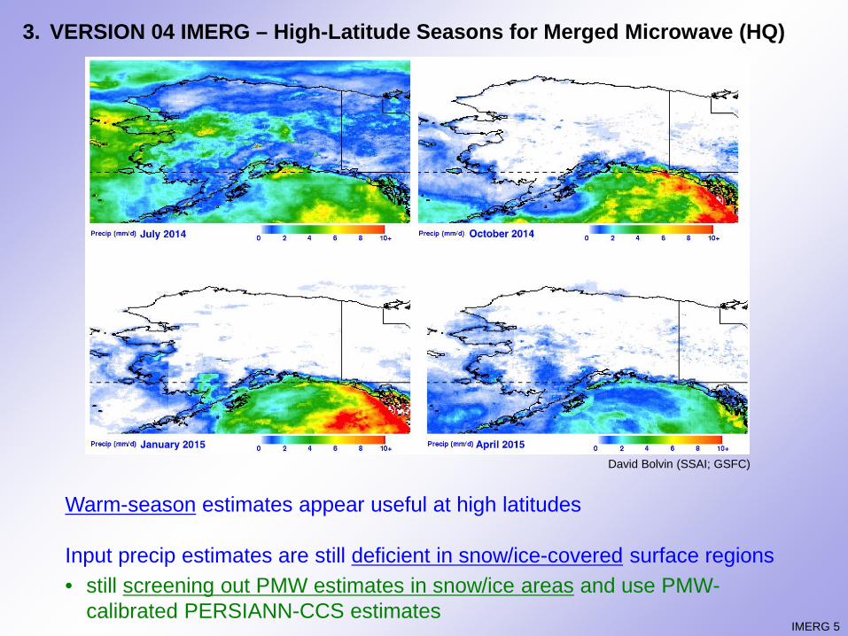
3. VERSION 04 IMERG – High-Latitude Seasons for Merged Microwave (HQ)
Warm-season estimates appear useful at high latitudes
Input precip estimates are still deficient in snow/ice-covered surface regions• still screening out PMW estimates in snow/ice areas and use PMW-
calibrated PERSIANN-CCS estimates
David Bolvin (SSAI; GSFC)
IMERG 5
3. VERSION 05 IMERG – GPM Core Products Are Low in Extratropical Oceans
Ocean-only zonals for 2015
V05 GPM products are similar, by design• V05 IMERG calibrated by 2BCMB at low
latitudes
GPCP is higher in the extratropics• Version 2.3 of community standard• Behrangi Multi-satellite CloudSat, TRMM,
Aqua (MCTA) product confirms GPM bias- includes CloudSat rain, snow, mixed- higher than GPCP in mid-latitudes- roughly agrees at high latitudes
Adjust IMERG V04, and now V05 to GPCP at higher lataitudes with seasonal “climatology”• provided reasonable IMERG bias in V04• low biases in GPM products addressed in
V05, but still low, still require GPCPPrecipitation Rate (mm/day)
4. VALIDATION – Accumulations over South Carolina, 1-5 October 2015
Bias decreases from V03 to V04 to V05• the gauge-only analysis shows more than MRMS• V03 and V04 lack the split near the coast, closer hint
in V05• V05 still puts the maximum too far inland• IMERG higher over the ocean, but need to consider
radar range artifacts for MRMS
Late V05 is not yetavailable• the uncal field in
Final should beapproximately thesame 5004003002001000mm
mm
IMERG-L V04
IMERG-L V03
MRMS IMERG-F uncal V05
NWS Gauge Analysis
4. VALIDATION – Half-Hourly V04 IMERG Sources and MRMS over South Carolina, 2-4 October 2015
“Violin diagram” for individual sources of the half-hourly IMERG estimates• width shows relative contribution for each difference bin• V03(V04) on left(right)
All rainfall rates, over land
V04 is an improvement for allsensors
No-PMW (interpolated andwith IR) data are competitive with the skill for most of thesensors
[J. Tan (UMBC; GSFC)]
IMERG 9
V03 V04
Number of cases
PrecipSource
[J. Tan (UMBC; GSFC)]
4. VALIDATION – Half-Hourly V04 IMERG Sources and MRMS over South Carolina, 2-4 October 2015
This diagram focuses solely on heavy rain• both ≥ 10 mm/h• small sample size for
AMSR2, GMI, ATMS• V04 better than V03• GMI and SSMIS are near
zero bias• new ATMS has issues (but
low number of samples)
V05 2BCMB has a better PDF at high rates• recall: it is the calibrator• expect improved IMERG
performance in floodsituations
PrecipSource
IMERG 10
Number of cases
D.Bolvin (SSAI; GSFC)
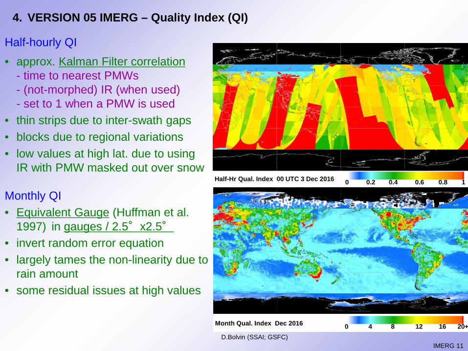
4. VERSION 05 IMERG – Quality Index (QI)
Half-hourly QI• approx. Kalman Filter correlation
- time to nearest PMWs- (not-morphed) IR (when used)- set to 1 when a PMW is used
• thin strips due to inter-swath gaps• blocks due to regional variations• low values at high lat. due to using
IR with PMW masked out over snow
Monthly QI• Equivalent Gauge (Huffman et al.
1997) in gauges / 2.5°x2.5°
• invert random error equation• largely tames the non-linearity due to
rain amount• some residual issues at high values
IMERG 11
Half-Hr Qual. Index 00 UTC 3 Dec 2016 0 0.2 0.4 0.6 0.8 1
Month Qual. Index Dec 2016 0 4 8 12 16 20+
5. FUTURE – Version Transitions
Early Spring 2017: Version 04, first-generation GPM-based IMERG archive, March 2014–present (Early, Late, Final)
Fall 2017: Version 05 IMERG, March 2014–present (Final; 1 December 2017-present for Early, Late, with retrospective back to March 2014 underway)• DPR calibration change• “minor”, but important upgrades to other algorithms• IMERG Quality Index• still no morphing outside 60°N-S
Spring 2018: TRMM V8/GPM V05 TRMM/GPM-based IMERG archive, 1998–present
Late Spring 2018: Legacy TMPA products retired
~2 years later: Version 06 IMERG
IMERG 12
6. FINAL COMMENTS
Versions 04 and 05 address issues uncovered in each previous version• swaths gridded over entire globe• GPCP calibration in many locations• improved input retrievals
Versions will move quickly over the next 12 months• GPM era being upgraded to Version 05 (Final done, Early and Late in process)• TRMM-GPM eras reprocessed in Version 05 in Spring 2018• TMPA to be run through Spring 2018
The future holds some “interesting” challenges, technical and institutional
“Last Week of IMERG” athttps://svs.gsfc.nasa.gov/cgi-
bin/details.cgi?aid=4285
On the Hyperwall Tues. 10 a.m., Wed. 4 p.m.
extra slides
IMERG 8
3. VERSION 04 IMERG – 2BCMB Largely Behaves as Expected for Spring 2015
Low-latitude ocean not adjusted; highest latitudes still show deficits• regional biases are modest
Latit
ude
Precipitation Rate (mm/day)
Ocean Spring 2015
2BCMB corr2BCMB uncorr
GPCP V2.3
Latit
ude
Precipitation Rate (mm/day)
Land Spring 2015
2BCMB corr2BCMB uncorr
GPCP V2.3
David BolvinDavid Bolvin
4. VALIDATION – Hurricane Harvey, 25-31 August 2017, IMERG and MRMS (1/2)
Harvey loitered over southeast Texas for a week• Multi-Radar Multi-Sensor (MRMS) considered the best estimate
- some questions about the details of the gauge calibration of the radar estimate- over land
• Late Run IMERG V04 under(over)-estimated in Area 1(2)
J. Tan (USRA; GSFC) IMERG 8
MRMS IMERG
J. Tan (USRA; GSFC)
4. VALIDATION – Hurricane Harvey, 25-31 August 2017, IMERG and MRMS (2/2)
The differences between MRMS (blue) and IMERG (orange) tend to be of the same sign as the event-averagedifference• less true in Area 2• some jumpiness in IMERG is due to
overpasses by different sensors• opposite-sign differences occurred
at the same time in the two areas• PMW-calibrated IR (green) is mostly
less than MRMS in both areas
This presumably tells us about the meteorology• “juicy”, liquid-process tropical
convection in Area 1• drier, more continental convection in