A Real-Time Water Quality A Real-Time Water Quality Monitoring Network for Monitoring Network for Investigating the Strengths and Investigating the Strengths and Weaknesses of Existing Weaknesses of Existing Monitoring Techniques Monitoring Techniques David K. Stevens David K. Stevens 1 , Jeffery S. Horsburgh , Jeffery S. Horsburgh 1 , , Nancy Mesner Nancy Mesner 2 Amber Spackman Amber Spackman 1 1 Utah Water Research Laboratory Utah Water Research Laboratory 2 Dept. of Aquatic, Watershed, and Earth Dept. of Aquatic, Watershed, and Earth Resources Resources Utah State University, Logan, UT Utah State University, Logan, UT
Transcript
A Real-Time Water Quality A Real-Time Water Quality Monitoring Network for Monitoring Network for
Investigating the Strengths and Investigating the Strengths and Weaknesses of Existing Weaknesses of Existing Monitoring TechniquesMonitoring Techniques
David K. StevensDavid K. Stevens11, Jeffery S. Horsburgh, Jeffery S. Horsburgh11, Nancy , Nancy MesnerMesner22
Amber SpackmanAmber Spackman11
11Utah Water Research LaboratoryUtah Water Research Laboratory22Dept. of Aquatic, Watershed, and Earth ResourcesDept. of Aquatic, Watershed, and Earth Resources
Utah State University, Logan, UTUtah State University, Logan, UT
The Interesting QuestionsThe Interesting Questions
► Is Is traditionaltraditional monitoring adequate to monitoring adequate to characterize natural or characterize natural or anthropogenic variability in flow and anthropogenic variability in flow and total phosphorus concentrations?total phosphorus concentrations?
►Do in stream monitoring data used in Do in stream monitoring data used in typical TMDLs focus too much on typical TMDLs focus too much on point source loads when intermittent point source loads when intermittent or infrequent nonpoint source loads or infrequent nonpoint source loads may be important?may be important?
Current projectCurrent project
► Continuous water quality monitoring effort Continuous water quality monitoring effort in the Little Bear River of Northern Utahin the Little Bear River of Northern Utah
continuous flow/water quality paired with continuous flow/water quality paired with periodic and storm event samplingperiodic and storm event sampling
designed to evaluate the strengths and designed to evaluate the strengths and weaknesses of each of the water quality weaknesses of each of the water quality monitoring techniquesmonitoring techniques
focus on correlating the results of high frequency focus on correlating the results of high frequency turbidity, oxygen, temperature, conductance and turbidity, oxygen, temperature, conductance and pH (possible others) monitoring with those of pH (possible others) monitoring with those of traditional samplingtraditional sampling
Little Bear River Watershed
near Logan (Cache County, Utah
Project LandscapeProject Landscape
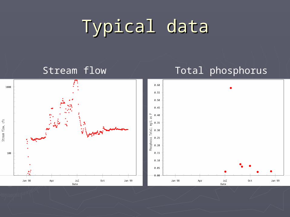
Typical dataTypical data
100
1000
Jan 98 Apr Jul Oct Jan 99
Str
eam
flow
, cfs
Date
0.00
0.05
0.10
0.15
0.20
0.25
0.30
0.35
0.40
0.45
0.50
0.55
0.60
Jan 98 Apr Jul Oct Jan 99
Pho
spho
rus
Tota
l; m
g/L
as P
Date
Stream flow Total phosphorus
Analysis of Monitoring Analysis of Monitoring TechniquesTechniques
► Turbidity as a surrogate measure for total Turbidity as a surrogate measure for total suspended solids (TSS) suspended solids (TSS) relationships can be established between turbidity relationships can be established between turbidity
(continuously), and periodic grab samples for TSS(continuously), and periodic grab samples for TSS relationships are site/time specific relationships are site/time specific
► Hypothesis: Nutrients, microbial Hypothesis: Nutrients, microbial contaminants, and organic matter can also be contaminants, and organic matter can also be correlated with turbidity, along with other correlated with turbidity, along with other water quality and station/time-specific water quality and station/time-specific measures to help assess loadingsmeasures to help assess loadings
►Probabilistic network models Probabilistic network models graphical representationgraphical representation relationships among variablesrelationships among variables
► exogenous,exogenous,► state, and state, and ►systemsystem
►Directed acyclic graph Directed acyclic graph causal structure of variablescausal structure of variables conditional probability distributions conditional probability distributions
C
B A
Little Bear River Sampling Little Bear River Sampling ProgramProgram
► Field samples collected weekly or bi-weekly Field samples collected weekly or bi-weekly depending on the time of year and analyzed for:depending on the time of year and analyzed for: Nutrients Nutrients Total suspended solidsTotal suspended solids Total dissolved solidsTotal dissolved solids
► Simultaneous spot checks of turbidity with a Simultaneous spot checks of turbidity with a portable field meterportable field meter
► Establish relationships between total phosphorus, Establish relationships between total phosphorus, total suspended, dissolved solids, turbidity, flow, total suspended, dissolved solids, turbidity, flow, time, watershed characteristics, otherstime, watershed characteristics, others
… … Starting this fallStarting this fall
► MonitoringMonitoring Add four continuous climate stationsAdd four continuous climate stations Add six new continuous water quality monitoring Add six new continuous water quality monitoring
stationsstations
► AnalysisAnalysis Construct time series of estimates for constituentsConstruct time series of estimates for constituents Study the high frequency patterns of estimated Study the high frequency patterns of estimated
► Greatly reduced uncertainty in flows and Greatly reduced uncertainty in flows and concentrations at a reasonable costconcentrations at a reasonable cost
Use large quantities of relatively low cost (read: Use large quantities of relatively low cost (read: less precise) data rather than small(er) quantities less precise) data rather than small(er) quantities of expensive (more precise) dataof expensive (more precise) data
► Potential characterization of pollutant Potential characterization of pollutant loading down to an hourly scale with loading down to an hourly scale with uncertainty estimates via Bayes networks?uncertainty estimates via Bayes networks?
Do in-stream monitoring data used in TMDLs Do in-stream monitoring data used in TMDLs focus too much on relatively steady point focus too much on relatively steady point source loads when intermittent or infrequent source loads when intermittent or infrequent nonpoint source loads are important?nonpoint source loads are important?
► Is it worth while for a POTW to install monitoring Is it worth while for a POTW to install monitoring equipment downstream of a discharge to better equipment downstream of a discharge to better characterize the full spectrum of loading in the characterize the full spectrum of loading in the stream? – as opposed to stream? – as opposed to
► Traditional ambient monitoring that may only Traditional ambient monitoring that may only characterize the times when characterize the times when loadingloading in the in the stream is dominated by WWTP discharges, e.g. stream is dominated by WWTP discharges, e.g. East Canyon Creek, Park City, UT - Up to 50 % of East Canyon Creek, Park City, UT - Up to 50 % of the flow at times is WWTP discharge, but 50% of the flow at times is WWTP discharge, but 50% of annualannual total phosphorus load may occur during total phosphorus load may occur during one storm eventone storm event
Where are we headed?Where are we headed?
► Rigorously explore the relationships between Rigorously explore the relationships between the surrogates and the parameters of interestthe surrogates and the parameters of interest
► Explore spatial/temporal influences on these Explore spatial/temporal influences on these relationshipsrelationships
► Analyze the significance of storm event loads Analyze the significance of storm event loads vs. base flow loadsvs. base flow loads
► Back next NWQMCBack next NWQMC
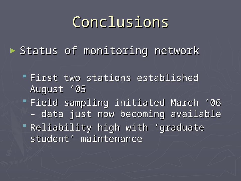
ConclusionsConclusions
►Status of monitoring networkStatus of monitoring network
First two stations established August ’05First two stations established August ’05 Field sampling initiated March ’06 – data Field sampling initiated March ’06 – data
just now becoming availablejust now becoming available Reliability high with ‘graduate student’ Reliability high with ‘graduate student’
maintenancemaintenance
ConclusionsConclusions
► FutureFuture Dramatically increase amount of dataDramatically increase amount of data
► flow, continuous, field water qualityflow, continuous, field water quality► climate (four new stations)climate (four new stations)
ExternalitiesExternalities► update/improve resolution of land use/land coverupdate/improve resolution of land use/land cover► update irrigation practice information (diversions, update irrigation practice information (diversions,
return flow, etc.) return flow, etc.) ► complete data acquisition for nutrient management complete data acquisition for nutrient management
pactices/BMPpactices/BMP Long termLong term
► help provide information for development of help provide information for development of hydrologic/environmental observatories with NSF/EPA hydrologic/environmental observatories with NSF/EPA supportsupport
AcknowledgementsAcknowledgements
►USDA/CEAPUSDA/CEAP►State of Utah, Division of Water QualityState of Utah, Division of Water Quality►Natural Resources Conservation ServiceNatural Resources Conservation Service►USU Water InitiativeUSU Water Initiative►Utah Water Research LaboratoryUtah Water Research Laboratory►National Science Foundation National Science Foundation
► Traditional water quality monitoring approachesTraditional water quality monitoring approaches grab and/or composite samplesgrab and/or composite samples supporting in-stream measurements of temperature, supporting in-stream measurements of temperature,
dissolved oxygen, pH, and specific conductancedissolved oxygen, pH, and specific conductance monthly, bi-weekly, or even weekly frequencymonthly, bi-weekly, or even weekly frequency inadequate to the variability in pollutant concentrationsinadequate to the variability in pollutant concentrations underestimation of pollutant loads and a greater focus underestimation of pollutant loads and a greater focus
on steady point source loading when intermittent or on steady point source loading when intermittent or infrequent nonpoint source loads are important but not infrequent nonpoint source loads are important but not characterized by grab samples.characterized by grab samples.
Objective 1Objective 1
► Construct time series of estimates for Construct time series of estimates for constituentsconstituents
Bayesian Network models Bayesian Network models ► real time estimation of constituent fluxes and real time estimation of constituent fluxes and
concentrations conditional upon surrogate concentrations conditional upon surrogate measurements.measurements.
Uncertainty associated with Bayesian Uncertainty associated with Bayesian estimates of constituent concentration and estimates of constituent concentration and loadingloading
► can be used to optimize the collection field can be used to optimize the collection field samplessamples
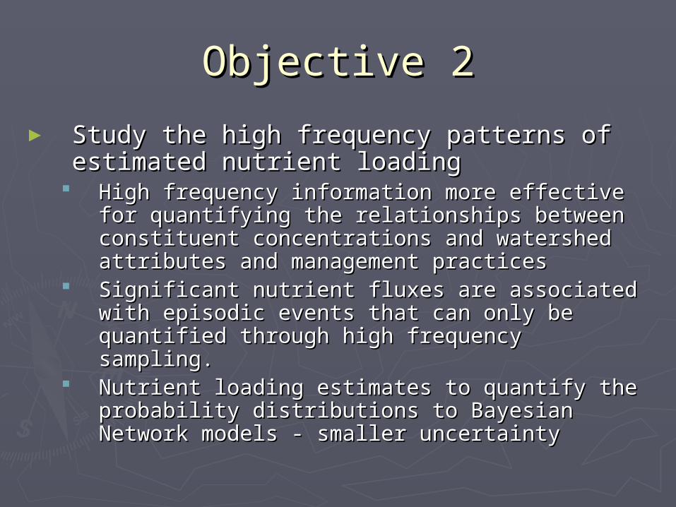
Objective 2Objective 2
► Study the high frequency patterns of Study the high frequency patterns of estimated nutrient loadingestimated nutrient loading
High frequency information more effective for High frequency information more effective for quantifying the relationships between quantifying the relationships between constituent concentrations and watershed constituent concentrations and watershed attributes and management practices attributes and management practices
Significant nutrient fluxes are associated with Significant nutrient fluxes are associated with episodic events that can only be quantified episodic events that can only be quantified through high frequency sampling.through high frequency sampling.
Nutrient loading estimates to quantify the Nutrient loading estimates to quantify the probability distributions to Bayesian Network probability distributions to Bayesian Network models - smaller uncertaintymodels - smaller uncertainty
Objective 3Objective 3
► CyberinfrastructureCyberinfrastructure Seamless, two-way linkages between sensors Seamless, two-way linkages between sensors
andand► a central observations database that stores and a central observations database that stores and
archives the observations;archives the observations;► models or data analysis software that use the data;models or data analysis software that use the data;► connected via a telemetry system;connected via a telemetry system;► interfaced with a central hydrologic observations interfaced with a central hydrologic observations
database via data filters and QA/QC.database via data filters and QA/QC. Data are immediately available for analysis, Data are immediately available for analysis,
modeling, and decision making.modeling, and decision making. Bayesian Network outputs to trigger the Bayesian Network outputs to trigger the
collection of field samples to estimate loadscollection of field samples to estimate loads
► Currently monitoringCurrently monitoring stream flow and turbidity at high frequency at two stream flow and turbidity at high frequency at two
sites relayed via radio frequency transmission to a sites relayed via radio frequency transmission to a base station at the Utah Water Research Laboratory. base station at the Utah Water Research Laboratory.
routine and episodic grab sampling at these two sitesroutine and episodic grab sampling at these two sites
► This fallThis fall instrument six additional sites, each of which is an instrument six additional sites, each of which is an
oxygen, specific conductance, and water temperatureoxygen, specific conductance, and water temperature expand field/automatic sampling efforts to new sitesexpand field/automatic sampling efforts to new sites
Little Bear River Sampling Little Bear River Sampling Program Program
Storm Event SamplingStorm Event Sampling►Automated sampling of storm eventsAutomated sampling of storm events►Triggered by precipitationTriggered by precipitation►Characterize the system responseCharacterize the system response►Rise and fall of storm hydrographRise and fall of storm hydrograph